Bridge Statistics for Emmett, Idaho (ID)
Condition, Traffic, Stress, Structural Evaluation, Project Costs
- National Bridge Inventory (NBI) Statistics
- 26Number of bridges
- 171ft / 52.0mTotal length
- $15,904,000Total costs
- 45,490Total average daily traffic
- 3,062Total average daily truck traffic
- 68,235Total future (year 2039) average daily traffic
- National Bridge Inventory (NBI) Registered Bridges for Emmett
- No street view available for this location
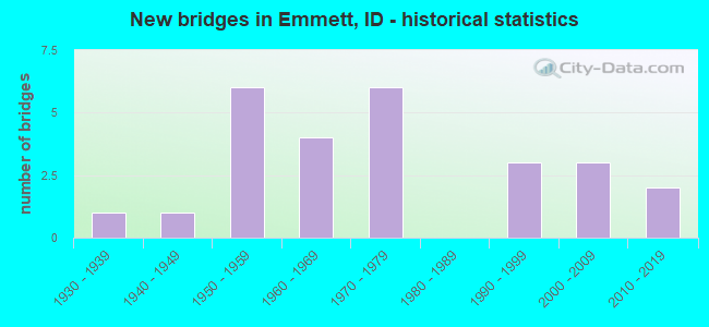
- New bridges - historical statistics
- 11930-1939
- 11940-1949
- 61950-1959
- 41960-1969
- 61970-1979
- 31990-1999
- 32000-2009
- 22010-2019

- Reconstructed bridges - Historical Statistics
- 11940-1949
- 11950-1959
- 01960-1969
- 01970-1979
- 11980-1989


- Bridge Condition - Deck
- 4.0%Very good
- 48.0%Good
- 20.0%Satisfactory
- 28.0%Fair

- Bridge Condition - Superstructure
- 4.0%Very good
- 20.0%Good
- 48.0%Satisfactory
- 28.0%Fair

- Bridge Condition - Substructure
- 8.0%Very good
- 16.0%Good
- 40.0%Satisfactory
- 36.0%Fair

- Bridge Condition - Channel
- 7.7%Excellent
- 38.5%Very good
- 30.8%Good
- 23.1%Satisfactory
Find on map >> Show street view
Structure Number: 1216, Location: 1.8 S. EMMETT (Lat: 43.858861, Lng: -116.463861), Route carried "on" structure: State highway 16, Year Built: 1966, Status: Open, Structure Length: 2.65m (8.69ft), Average Daily Traffic: 10,000 (year 2019), Truck Traffic: 6%, Average Future Daily Traffic: 15,000 (year 2039), Design Load: HS 20, Features Intersected: BLACK CANYON CANAL
Minimum Vertical Clearance: 30+ m (98+ ft), Kilometerpoint: 180.344, Lanes on structure: 2, Base Highway Network: Yes, Owner: State Highway Agency, Approaching Roadway Width: 10.4m (34.1ft), Skew: 2 degrees, Material/Design: Concrete, Design/Construction: Stringer/Multi-beam, Number Of Spans In Main Unit: 3, Length of Maximum Span: 8.5m (27.9ft), Curb-To-Curb Width: 10.4m (34.1ft), Out-to-Out Width: 11.1m (36.4ft)
Condition: Deck: Satisfactory, Superstructure: Satisfactory, Substructure: Fair, Channel: Good, Operating Rating: 58.1 metric tons, Method Used To Determine Operating Rating: Load Factor (LF), Inventory Rating: 35.4 metric tons, Method Used To Determine Inventory Rating: Load Factor (LF), Structural Evaluation: Somewhat better than minimum adequacy, Deck Geometry: Meets minimum limits, Waterway Adequacy: Equal to present desirable criteria, Approach Roadway Alignment: Equal to present desirable criteria, Length Of Structure Improvement: 3.44m (11.29ft), Designated Inspection Frequency: Every 24 months, Inspection Date: January 2021, Bridge Improvement Cost: $895,000, Roadway Improvement Cost: $90,000, Total Project Cost: $1,342,000 ( Estimate for 2021), Deck Structure Type: Concrete Cast-file-Place, Wearing Surface/Protective System: Wearing Surface: Bituminous, Membrane: Preformed Fabric
Find on map >> Show street view
Structure Number: 14641, Location: 0.2 W. EMMETT (Lat: 43.861250, Lng: -116.503028), Route carried "on" structure: State highway 52, Year Built: 2001, Status: Open, Structure Length: 1.07m (3.51ft), Average Daily Traffic: 5,300 (year 2019), Truck Traffic: 10%, Average Future Daily Traffic: 7,950 (year 2039), Design Load: HS 25 or greater, Features Intersected: FARMERS COOP CANAL
Minimum Vertical Clearance: 30+ m (98+ ft), Kilometerpoint: 48.715, Lanes on structure: 3, Base Highway Network: Yes, Owner: State Highway Agency, Approaching Roadway Width: 15.8m (51.8ft), Material/Design: Prestressed concrete, Design/Construction: Box Beam or Girders - Multiple, Number Of Spans In Main Unit: 1, Length of Maximum Span: 10.2m (33.5ft), Curb or Sidewalk Widths: Left: 0.1m (0.3ft), Right: 0.1m (0.3ft), Curb-To-Curb Width: 24.9m (81.7ft), Out-to-Out Width: 25.6m (84.0ft)
Condition: Deck: Good, Superstructure: Good, Substructure: Good, Channel: Very good, Operating Rating: 89.8 metric tons, Method Used To Determine Operating Rating: Load Factor (LF), Inventory Rating: 50.8 metric tons, Method Used To Determine Inventory Rating: Load Factor (LF), Structural Evaluation: Better than present minimum criteria, Deck Geometry: Superior to present desirable criteria, Waterway Adequacy: Equal to present desirable criteria, Approach Roadway Alignment: Equal to present desirable criteria, Designated Inspection Frequency: Every 48 months, Inspection Date: March 2020, Deck Structure Type: Concrete Precast Panels, Wearing Surface/Protective System: Wearing Surface: Bituminous, Membrane: Preformed Fabric, Deck Protection: Epoxy Coated Reinforcing
Find on map >> Show street view
Structure Number: 14646, Location: IN EMMETT (Lat: 43.877139, Lng: -116.500083), Route carried "on" structure: State highway 52, Year Built: 1992, Status: Open, Structure Length: 1.25m (4.10ft), Average Daily Traffic: 9,000 (year 2019), Truck Traffic: 3%, Average Future Daily Traffic: 13,500 (year 2039), Design Load: HS 25 or greater, Features Intersected: FARMERS COOP CANAL
Minimum Vertical Clearance: 30+ m (98+ ft), Kilometerpoint: 50.736, Lanes on structure: 2, Base Highway Network: Yes, Owner: State Highway Agency, Approaching Roadway Width: 17.1m (56.1ft), Skew: 1 degrees, Material/Design: Concrete, Design/Construction: Frame, Number Of Spans In Main Unit: 2, Length of Maximum Span: 5.5m (18.0ft), Curb or Sidewalk Widths: Left: 3.7m (12.1ft), Right: 3.7m (12.1ft), Curb-To-Curb Width: 17.1m (56.1ft), Out-to-Out Width: 24.4m (80.1ft)
Condition: Deck: Good, Superstructure: Good, Substructure: Good, Channel: Very good, Operating Rating: 90.6 metric tons, Method Used To Determine Operating Rating: Load Factor (LF), Inventory Rating: 61.7 metric tons, Method Used To Determine Inventory Rating: Load Factor (LF), Structural Evaluation: Better than present minimum criteria, Deck Geometry: Superior to present desirable criteria, Waterway Adequacy: Equal to present desirable criteria, Approach Roadway Alignment: Equal to present desirable criteria, Designated Inspection Frequency: Every 48 months, Inspection Date: March 2020, Deck Structure Type: Concrete Cast-file-Place, Wearing Surface/Protective System: Wearing Surface: Bituminous, Membrane: Preformed Fabric
Find on map >> Show street view
Structure Number: 1465, Location: IN EMMETT (Lat: 43.881739, Lng: -116.500169), Route carried "on" structure: State highway 52, Year Built: 1971, Status: Open, Structure Length: 10.36m (33.99ft), Average Daily Traffic: 4,700 (year 2019), Truck Traffic: 10%, Average Future Daily Traffic: 7,050 (year 2039), Design Load: HS 20, Features Intersected: PAYETTE RIVER;EMMETT BR.
Minimum Vertical Clearance: 30+ m (98+ ft), Kilometerpoint: 51.248, Lanes on structure: 2, Base Highway Network: Yes, Owner: State Highway Agency, Approaching Roadway Width: 9.1m (29.9ft), Material/Design: Prestressed concrete, Design/Construction: Stringer/Multi-beam, Number Of Spans In Main Unit: 5, Length of Maximum Span: 20.3m (66.6ft), Curb or Sidewalk Widths: Left: 1.3m (4.3ft), Right: 0.0m, Curb-To-Curb Width: 9.1m (29.9ft), Out-to-Out Width: 11.8m (38.7ft)
Condition: Deck: Fair, Superstructure: Satisfactory, Substructure: Fair, Channel: Satisfactory, Operating Rating: 75.3 metric tons, Method Used To Determine Operating Rating: Load Factor (LF), Inventory Rating: 42.6 metric tons, Method Used To Determine Inventory Rating: Load Factor (LF), Structural Evaluation: Somewhat better than minimum adequacy, Deck Geometry: Meets minimum limits, Waterway Adequacy: Equal to present desirable criteria, Approach Roadway Alignment: Equal to present desirable criteria, Length Of Structure Improvement: 11.28m (37.01ft), Designated Inspection Frequency: Every 24 months, Underwater Inspection Frequency: Every 60 months, Inspection Date: March 2020, Underwater Inspection Date: September 2018, Bridge Improvement Cost: $3,785,000, Roadway Improvement Cost: $379,000, Total Project Cost: $5,678,000 ( Estimate for 2020), Deck Structure Type: Concrete Cast-file-Place, Wearing Surface/Protective System: Wearing Surface: Latex Concrete
Find on map >> Show street view
Structure Number: 1994, Location: 3.3 N. 2.8 E. EMMETT (Lat: 43.922500, Lng: -116.444861), Route carried "on" structure: County highway 3838, Year Built: 1959, Status: Open, Structure Length: 7.32m (24.02ft), Average Daily Traffic: 880 (year 2019), Truck Traffic: 8%, Average Future Daily Traffic: 1,320 (year 2039), Design Load: H 15, Features Intersected: PAYETTE RIVER;PLAZA BR.
Minimum Vertical Clearance: 30+ m (98+ ft), Kilometerpoint: 16.534, Lanes on structure: 2, Owner: County Highway Agency, Approaching Roadway Width: 7.3m (24.0ft), Material/Design: Concrete, Design/Construction: Stringer/Multi-beam, Number Of Spans In Main Unit: 6, Length of Maximum Span: 11.9m (39.0ft), Curb or Sidewalk Widths: Left: 0.3m (1.0ft), Right: 0.3m (1.0ft), Curb-To-Curb Width: 7.3m (24.0ft), Out-to-Out Width: 8.1m (26.6ft)
Condition: Deck: Fair, Superstructure: Fair, Substructure: Satisfactory, Channel: Very good, Operating Rating: 46.3 metric tons, Method Used To Determine Operating Rating: Load Factor (LF), Inventory Rating: 27.2 metric tons, Method Used To Determine Inventory Rating: Load Factor (LF), Structural Evaluation: Somewhat better than minimum adequacy, Deck Geometry: Meets minimum limits, Waterway Adequacy: Equal to present desirable criteria, Approach Roadway Alignment: Equal to present minimum criteria, Length Of Structure Improvement: 8.44m (27.69ft), Designated Inspection Frequency: Every 24 months, Underwater Inspection Frequency: Every 60 months, Inspection Date: July 2021, Underwater Inspection Date: September 2018, Bridge Improvement Cost: $2,194,000, Roadway Improvement Cost: $219,000, Total Project Cost: $3,291,000 ( Estimate for 2017), Deck Structure Type: Concrete Cast-file-Place, Wearing Surface/Protective System: Wearing Surface: Bituminous
Find on map >> Show street view
Structure Number: 19971, Location: 0.4 S 1.2 E EMMETT (Lat: 43.869917, Lng: -116.472806), Route carried "on" structure: City street 7190, Year Built: 2016, Status: Open, Structure Length: 0.91m (2.99ft), Average Daily Traffic: 5,300 (year 2019), Truck Traffic: 3%, Average Future Daily Traffic: 7,950 (year 2039), Design Load: HL 93, Features Intersected: LAST CHANCE CANAL
Minimum Vertical Clearance: 30+ m (98+ ft), Kilometerpoint: 3.885, Lanes on structure: 2, Owner: City or Municipal Highway Agency, Approaching Roadway Width: 7.3m (24.0ft), Skew: 6 degrees, Material/Design: Concrete, Design/Construction: Frame, Number Of Spans In Main Unit: 1, Length of Maximum Span: 9.1m (29.9ft), Curb or Sidewalk Widths: Left: 1.7m (5.6ft), Right: 1.7m (5.6ft), Curb-To-Curb Width: 18.3m (60.0ft), Out-to-Out Width: 23.9m (78.4ft)
Condition: Deck: Very good, Superstructure: Very good, Substructure: Very good, Channel: Excellent, Operating Rating: 70.3 metric tons, Method Used To Determine Operating Rating: Load and Resistance Factor Rating (LRFR) rating reported by rating factor(RF) method using HL-93 loadings, Inventory Rating: 54.1 metric tons, Method Used To Determine Inventory Rating: Load and Resistance Factor Rating (LRFR) rating reported by rating factor(RF) method using HL-93 loadings, Structural Evaluation: Equal to present desirable criteria, Deck Geometry: Superior to present desirable criteria, Waterway Adequacy: Equal to present desirable criteria, Approach Roadway Alignment: Equal to present desirable criteria, Designated Inspection Frequency: Every 48 months, Inspection Date: November 2019, Deck Structure Type: Concrete Precast Panels, Wearing Surface/Protective System: Wearing Surface: Bituminous, Membrane: Preformed Fabric
Find on map >> Show street view
Structure Number: 19977, Location: 0.6 S 1.1 E EMMETT (Lat: 43.866569, Lng: -116.476281), Route carried "on" structure: City street , Year Built: 2008, Status: Closed, Structure Length: 0.73m (2.40ft), Design Load: HS 25 or greater, Features Intersected: LAST CHANCE CANAL, Facility Carried by Structure: E 10TH STREET
Minimum Vertical Clearance: 30+ m (98+ ft), Kilometerpoint: 0.085, Lanes on structure: 2, Owner: City or Municipal Highway Agency, Approaching Roadway Width: 7.3m (24.0ft), Material/Design: Concrete, Design/Construction: Frame, Number Of Spans In Main Unit: 1, Length of Maximum Span: 7.3m (24.0ft), Curb-To-Curb Width: 7.6m (24.9ft), Out-to-Out Width: 7.6m (24.9ft)
Condition: Deck: Good, Superstructure: Good, Substructure: Good, Channel: Very good, Inventory Rating: 79.8 metric tons, Method Used To Determine Inventory Rating: Load Factor (LF), Structural Evaluation: Better than present minimum criteria, Deck Geometry: Equal to present minimum criteria, Waterway Adequacy: Superior to present desirable criteria, Approach Roadway Alignment: Better than present minimum criteria, Designated Inspection Frequency: Every 48 months, Inspection Date: October 2021, Deck Structure Type: Concrete Precast Panels
Find on map >> Show street view
Structure Number: 28005, Location: 2.4 S. 3.3 W. EMMETT (Lat: 43.836972, Lng: -116.567417), Route carried "on" structure: County highway 3842, Year Built: 1976, Status: Open, Structure Length: 1.04m (3.41ft), Average Daily Traffic: 250 (year 2019), Truck Traffic: 16%, Average Future Daily Traffic: 375 (year 2039), Design Load: HS 15, Features Intersected: FARMERS COOP CANAL
Minimum Vertical Clearance: 30+ m (98+ ft), Kilometerpoint: 161.064, Lanes on structure: 2, Owner: County Highway Agency, Approaching Roadway Width: 5.5m (18.0ft), Skew: 3 degrees, Material/Design: Prestressed concrete, Design/Construction: Tee Beam, Number Of Spans In Main Unit: 1, Length of Maximum Span: 10.1m (33.1ft), Curb-To-Curb Width: 7.9m (25.9ft), Out-to-Out Width: 8.5m (27.9ft)
Condition: Deck: Good, Superstructure: Fair, Substructure: Fair, Channel: Good, Operating Rating: 27.2 metric tons, Method Used To Determine Operating Rating: Field evaluation and documented engineering judgment, Inventory Rating: 16.3 metric tons, Method Used To Determine Inventory Rating: Field evaluation and documented engineering judgment, Structural Evaluation: Somewhat better than minimum adequacy, Deck Geometry: Somewhat better than minimum adequacy, Waterway Adequacy: Superior to present desirable criteria, Approach Roadway Alignment: Equal to present desirable criteria, Length Of Structure Improvement: 1.65m (5.41ft), Designated Inspection Frequency: Every 24 months, Inspection Date: March 2021, Bridge Improvement Cost: $267,000, Roadway Improvement Cost: $27,000, Total Project Cost: $401,000 ( Estimate for 2021), Deck Structure Type: Concrete Cast-file-Place, Wearing Surface/Protective System: Wearing Surface: Bituminous
Find on map >> Show street view
Structure Number: 2801, Location: 1.6 S. 5.1 W. EMMETT (Lat: 43.852583, Lng: -116.603056), Route carried "on" structure: County highway , Year Built: 1955, Status: Open, Structure Length: 0.85m (2.79ft), Average Daily Traffic: 630 (year 2019), Truck Traffic: 5%, Average Future Daily Traffic: 945 (year 2039), Design Load: HS 15, Features Intersected: FARMERS COOP CANAL, Facility Carried by Structure: W SOUTH SLOPE RD
Minimum Vertical Clearance: 30+ m (98+ ft), Kilometerpoint: 161.126, Lanes on structure: 2, Owner: County Highway Agency, Approaching Roadway Width: 4.9m (16.1ft), Skew: 3 degrees, Material/Design: Steel, Design/Construction: Stringer/Multi-beam, Number Of Spans In Main Unit: 1, Length of Maximum Span: 8.2m (26.9ft), Curb-To-Curb Width: 6.3m (20.7ft), Out-to-Out Width: 6.6m (21.7ft)
Condition: Deck: Fair, Superstructure: Fair, Substructure: Fair, Channel: Satisfactory, Operating Rating: 36.0 metric tons, Method Used To Determine Operating Rating: Allowable Stress (AS), Inventory Rating: 26.1 metric tons, Method Used To Determine Inventory Rating: Allowable Stress (AS), Structural Evaluation: Somewhat better than minimum adequacy, Deck Geometry: High priority of corrective action, Waterway Adequacy: Superior to present desirable criteria, Approach Roadway Alignment: Equal to present minimum criteria, Length Of Structure Improvement: 1.49m (4.89ft), Designated Inspection Frequency: Every 24 months, Inspection Date: March 2021, Bridge Improvement Cost: $275,000, Roadway Improvement Cost: $28,000, Total Project Cost: $413,000 ( Estimate for 2019), Deck Structure Type: Concrete Cast-file-Place, Wearing Surface/Protective System: Wearing Surface: Bituminous
Find on map >> Show street view
Structure Number: 2805, Location: 1.6 N. 3.4 E. EMMETT (Lat: 43.899944, Lng: -116.432417), Route carried "on" structure: County highway , Year Built: 1976, Status: Open, Structure Length: 2.19m (7.19ft), Average Daily Traffic: 100 (year 2019), Truck Traffic: 10%, Average Future Daily Traffic: 150 (year 2039), Design Load: H 15, Features Intersected: BLACK CANYON CANAL, Facility Carried by Structure: FULLER ROAD
Minimum Vertical Clearance: 30+ m (98+ ft), Kilometerpoint: 161.615, Lanes on structure: 2, Owner: County Highway Agency, Approaching Roadway Width: 6.1m (20.0ft), Skew: 2 degrees, Material/Design: Prestressed concrete, Design/Construction: Tee Beam, Number Of Spans In Main Unit: 1, Length of Maximum Span: 21.3m (69.9ft), Curb-To-Curb Width: 8.0m (26.2ft), Out-to-Out Width: 8.5m (27.9ft)
Condition: Deck: Good, Superstructure: Satisfactory, Substructure: Satisfactory, Channel: Good, Operating Rating: 29.7 metric tons, Method Used To Determine Operating Rating: Allowable Stress (AS), Inventory Rating: 20.7 metric tons, Method Used To Determine Inventory Rating: Allowable Stress (AS), Structural Evaluation: Equal to present minimum criteria, Deck Geometry: Equal to present minimum criteria, Waterway Adequacy: Superior to present desirable criteria, Approach Roadway Alignment: Equal to present minimum criteria, Length Of Structure Improvement: 2.96m (9.71ft), Designated Inspection Frequency: Every 48 months, Inspection Date: October 2018, Bridge Improvement Cost: $448,000, Roadway Improvement Cost: $45,000, Total Project Cost: $672,000, Deck Structure Type: Concrete Cast-file-Place, Wearing Surface/Protective System: Wearing Surface: Bituminous
Find on map >> Show street view
Structure Number: 28055, Location: 3.0 N. EMMETT;VAN DEUSEN (Lat: 43.921111, Lng: -116.503169), Route carried "on" structure: County highway , Year Built: 1969, Status: Open, Structure Length: 0.91m (2.99ft), Average Daily Traffic: 260 (year 2019), Truck Traffic: 12%, Average Future Daily Traffic: 390 (year 2039), Design Load: HS 20, Features Intersected: NORTHSIDE MAIN CANAL, Facility Carried by Structure: VAN DEUSEN RD
Minimum Vertical Clearance: 30+ m (98+ ft), Kilometerpoint: 162.400, Lanes on structure: 2, Owner: County Highway Agency, Approaching Roadway Width: 5.5m (18.0ft), Skew: 1 degrees, Material/Design: Prestressed concrete, Design/Construction: Tee Beam, Number Of Spans In Main Unit: 1, Length of Maximum Span: 8.8m (28.9ft), Curb-To-Curb Width: 8.5m (27.9ft), Out-to-Out Width: 9.1m (29.9ft)
Condition: Deck: Good, Superstructure: Satisfactory, Substructure: Satisfactory, Channel: Good, Operating Rating: 51.3 metric tons, Method Used To Determine Operating Rating: Allowable Stress (AS), Inventory Rating: 36.0 metric tons, Method Used To Determine Inventory Rating: Allowable Stress (AS), Structural Evaluation: Equal to present minimum criteria, Deck Geometry: Equal to present minimum criteria, Waterway Adequacy: Equal to present desirable criteria, Approach Roadway Alignment: Better than present minimum criteria, Designated Inspection Frequency: Every 24 months, Inspection Date: October 2021, Deck Structure Type: Concrete Cast-file-Place, Wearing Surface/Protective System: Wearing Surface: Bituminous
Find on map >> Show street view
Structure Number: 2806, Location: 1.3 S. 1.8 E. EMMETT (Lat: 43.857389, Lng: -116.465500), Route carried "on" structure: County highway 9584, Year Built: 1979, Status: Open, Structure Length: 2.01m (6.59ft), Average Daily Traffic: 320 (year 2019), Average Future Daily Traffic: 480 (year 2039), Design Load: H 15, Features Intersected: BLACK CANYON CANAL
Minimum Vertical Clearance: 30+ m (98+ ft), Kilometerpoint: 163.126, Lanes on structure: 2, Owner: County Highway Agency, Approaching Roadway Width: 5.8m (19.0ft), Skew: 1 degrees, Material/Design: Prestressed concrete, Design/Construction: Tee Beam, Number Of Spans In Main Unit: 1, Length of Maximum Span: 19.5m (64.0ft), Curb-To-Curb Width: 8.0m (26.2ft), Out-to-Out Width: 8.5m (27.9ft)
Condition: Deck: Satisfactory, Superstructure: Satisfactory, Substructure: Satisfactory, Channel: Satisfactory, Operating Rating: 29.7 metric tons, Method Used To Determine Operating Rating: Allowable Stress (AS), Inventory Rating: 20.7 metric tons, Method Used To Determine Inventory Rating: Allowable Stress (AS), Structural Evaluation: Equal to present minimum criteria, Deck Geometry: Somewhat better than minimum adequacy, Waterway Adequacy: Superior to present desirable criteria, Approach Roadway Alignment: Better than present minimum criteria, Length Of Structure Improvement: 2.83m (9.28ft), Designated Inspection Frequency: Every 24 months, Inspection Date: October 2021, Bridge Improvement Cost: $428,000, Roadway Improvement Cost: $43,000, Total Project Cost: $642,000 ( Estimate for 2017), Deck Structure Type: Concrete Cast-file-Place, Wearing Surface/Protective System: Wearing Surface: Bituminous
Find on map >> Show street view
Structure Number: 28065, Location: IN EMMETT; W. 12TH ST (Lat: 43.864667, Lng: -116.503028), Route carried "on" structure: City street 7408, Year Built: 1965, Status: Open, Structure Length: 0.79m (2.59ft), Average Daily Traffic: 1,900 (year 2019), Truck Traffic: 4%, Average Future Daily Traffic: 2,850 (year 2039), Design Load: HS 20, Features Intersected: FARMERS COOP CANAL
Minimum Vertical Clearance: 30+ m (98+ ft), Kilometerpoint: 163.119, Lanes on structure: 2, Owner: City or Municipal Highway Agency, Approaching Roadway Width: 7.6m (24.9ft), Material/Design: Prestressed concrete, Design/Construction: Tee Beam, Number Of Spans In Main Unit: 1, Length of Maximum Span: 7.6m (24.9ft), Curb or Sidewalk Widths: Left: 0.0m, Right: 1.6m (5.2ft), Curb-To-Curb Width: 9.0m (29.5ft), Out-to-Out Width: 11.0m (36.1ft)
Condition: Deck: Satisfactory, Superstructure: Fair, Substructure: Satisfactory, Channel: Very good, Operating Rating: 48.6 metric tons, Method Used To Determine Operating Rating: Allowable Stress (AS), Inventory Rating: 35.1 metric tons, Method Used To Determine Inventory Rating: Allowable Stress (AS), Structural Evaluation: Somewhat better than minimum adequacy, Deck Geometry: Somewhat better than minimum adequacy, Waterway Adequacy: Equal to present desirable criteria, Approach Roadway Alignment: Equal to present desirable criteria, Designated Inspection Frequency: Every 24 months, Inspection Date: March 2021, Deck Structure Type: Concrete Cast-file-Place, Wearing Surface/Protective System: Wearing Surface: Bituminous
Find on map >> Show street view
Structure Number: 2807, Location: 1.2 N. 3.1 E. EMMETT (Lat: 43.893750, Lng: -116.436500), Route carried "on" structure: County highway , Year Built: 1977, Status: Open, Structure Length: 1.98m (6.50ft), Average Daily Traffic: 150 (year 2019), Truck Traffic: 10%, Average Future Daily Traffic: 225 (year 2039), Design Load: H 15, Features Intersected: BLACK CANYON CANAL, Facility Carried by Structure: FROZEN DOG ROAD
Minimum Vertical Clearance: 30+ m (98+ ft), Kilometerpoint: 162.209, Lanes on structure: 2, Owner: County Highway Agency, Approaching Roadway Width: 4.9m (16.1ft), Material/Design: Prestressed concrete, Design/Construction: Tee Beam, Number Of Spans In Main Unit: 1, Length of Maximum Span: 19.2m (63.0ft), Curb-To-Curb Width: 8.0m (26.2ft), Out-to-Out Width: 8.5m (27.9ft)
Condition: Deck: Satisfactory, Superstructure: Satisfactory, Substructure: Satisfactory, Channel: Good, Operating Rating: 29.7 metric tons, Method Used To Determine Operating Rating: Allowable Stress (AS), Inventory Rating: 20.7 metric tons, Method Used To Determine Inventory Rating: Allowable Stress (AS), Structural Evaluation: Equal to present minimum criteria, Deck Geometry: Somewhat better than minimum adequacy, Waterway Adequacy: Superior to present desirable criteria, Approach Roadway Alignment: Better than present minimum criteria, Designated Inspection Frequency: Every 48 months, Inspection Date: October 2019, Deck Structure Type: Concrete Cast-file-Place, Wearing Surface/Protective System: Wearing Surface: Bituminous
Find on map >> Show street view
Structure Number: 2808, Location: 0.6 S. 2.7;W. EMMETT (Lat: 43.868361, Lng: -116.552667), Route carried "on" structure: County highway , Year Built: 1950, Status: Open, Structure Length: 0.76m (2.49ft), Average Daily Traffic: 840 (year 2019), Truck Traffic: 13%, Average Future Daily Traffic: 1,260 (year 2039), Design Load: H 15, Features Intersected: ENTERPRISE CANAL, Facility Carried by Structure: CASCADE ROAD
Minimum Vertical Clearance: 30+ m (98+ ft), Kilometerpoint: 2.620, Lanes on structure: 2, Owner: County Highway Agency, Approaching Roadway Width: 6.7m (22.0ft), Skew: 5 degrees, Material/Design: Concrete, Design/Construction: Slab, Number Of Spans In Main Unit: 1, Length of Maximum Span: 7.6m (24.9ft), Curb or Sidewalk Widths: Left: 0.2m (0.7ft), Right: 0.2m (0.7ft), Curb-To-Curb Width: 7.6m (24.9ft), Out-to-Out Width: 8.0m (26.2ft)
Condition: Deck: Fair, Superstructure: Fair, Substructure: Fair, Channel: Good, Operating Rating: 40.5 metric tons, Method Used To Determine Operating Rating: Allowable Stress (AS), Inventory Rating: 24.3 metric tons, Method Used To Determine Inventory Rating: Allowable Stress (AS), Structural Evaluation: Somewhat better than minimum adequacy, Deck Geometry: Meets minimum limits, Waterway Adequacy: Equal to present desirable criteria, Approach Roadway Alignment: Equal to present desirable criteria, Length Of Structure Improvement: 1.37m (4.49ft), Designated Inspection Frequency: Every 24 months, Inspection Date: November 2020, Bridge Improvement Cost: $252,000, Roadway Improvement Cost: $25,000, Total Project Cost: $378,000 ( Estimate for 2020), Deck Structure Type: Concrete Cast-file-Place, Wearing Surface/Protective System: Wearing Surface: Bituminous
Find on map >> Show street view
Structure Number: 28085, Location: 2.7 S. 0.8 E. EMMETT (Lat: 43.837944, Lng: -116.484611), Route carried "on" structure: County highway 3842, Year Built: 1950, Status: Open, Structure Length: 3.02m (9.91ft), Average Daily Traffic: 310 (year 2019), Truck Traffic: 19%, Average Future Daily Traffic: 465 (year 2039), Design Load: HS 20, Features Intersected: BLACK CANYON CANAL
Minimum Vertical Clearance: 30+ m (98+ ft), Kilometerpoint: 172.906, Lanes on structure: 2, Owner: County Highway Agency, Approaching Roadway Width: 5.8m (19.0ft), Skew: 3 degrees, Material/Design: Steel, Design/Construction: Stringer/Multi-beam, Number Of Spans In Main Unit: 2, Length of Maximum Span: 14.0m (45.9ft), Curb or Sidewalk Widths: Left: 0.1m (0.3ft), Right: 0.1m (0.3ft), Curb-To-Curb Width: 8.1m (26.6ft), Out-to-Out Width: 9.3m (30.5ft)
Condition: Deck: Satisfactory, Superstructure: Satisfactory, Substructure: Fair, Channel: Very good, Operating Rating: 46.3 metric tons, Method Used To Determine Operating Rating: Load Factor (LF), Inventory Rating: 27.2 metric tons, Method Used To Determine Inventory Rating: Load Factor (LF), Structural Evaluation: Somewhat better than minimum adequacy, Deck Geometry: Somewhat better than minimum adequacy, Waterway Adequacy: Superior to present desirable criteria, Approach Roadway Alignment: Equal to present minimum criteria, Length Of Structure Improvement: 3.87m (12.70ft), Designated Inspection Frequency: Every 24 months, Inspection Date: October 2021, Bridge Improvement Cost: $629,000, Roadway Improvement Cost: $63,000, Total Project Cost: $944,000 ( Estimate for 2019), Deck Structure Type: Concrete Cast-file-Place, Wearing Surface/Protective System: Wearing Surface: Bituminous
Find on map >> Show street view
Structure Number: 28101, Location: 0.1 S. 4.4 W. EMMETT (Lat: 43.873189, Lng: -116.594961), Route carried "on" structure: County highway , Year Built: 2013, Status: Open, Structure Length: 1.65m (5.41ft), Average Daily Traffic: 450 (year 2019), Truck Traffic: 9%, Average Future Daily Traffic: 675 (year 2039), Design Load: HL 93, Features Intersected: SEVEN MILE SLOUGH, Facility Carried by Structure: VANDERDASSON RD
Minimum Vertical Clearance: 30+ m (98+ ft), Kilometerpoint: 166.854, Lanes on structure: 2, Owner: County Highway Agency, Approaching Roadway Width: 7.3m (24.0ft), Skew: 3 degrees, Material/Design: Steel, Design/Construction: Culvert, Number Of Spans In Main Unit: 5, Length of Maximum Span: 2.4m (7.9ft), Curb-To-Curb Width: 15.4m (50.5ft), Out-to-Out Width: 16.0m (52.5ft)
Condition: Channel: Good, Culverts: Good, Operating Rating: 97.2 metric tons, Method Used To Determine Operating Rating: Load and Resistance Factor Rating (LRFR) rating reported by rating factor(RF) method using HL-93 loadings, Inventory Rating: 79.7 metric tons, Method Used To Determine Inventory Rating: Load and Resistance Factor Rating (LRFR) rating reported by rating factor(RF) method using HL-93 loadings, Structural Evaluation: Better than present minimum criteria, Deck Geometry: Superior to present desirable criteria, Waterway Adequacy: Better than present minimum criteria, Approach Roadway Alignment: Equal to present desirable criteria, Designated Inspection Frequency: Every 48 months, Inspection Date: November 2021
Find on map >> Show street view
Structure Number: 28105, Location: 2.9 S. 0.6 W. EMMETT (Lat: 43.834667, Lng: -116.512694), Route carried "on" structure: County highway , Year Built: 1950, Status: Open, Structure Length: 0.91m (2.99ft), Average Daily Traffic: 170 (year 2019), Truck Traffic: 10%, Average Future Daily Traffic: 255 (year 2039), Design Load: HS 20, Features Intersected: FARMERS COOP CANAL, Facility Carried by Structure: MILL ROAD
Minimum Vertical Clearance: 30+ m (98+ ft), Kilometerpoint: 161.040, Lanes on structure: 2, Owner: County Highway Agency, Approaching Roadway Width: 6.1m (20.0ft), Skew: 3 degrees, Material/Design: Steel, Design/Construction: Stringer/Multi-beam, Number Of Spans In Main Unit: 1, Length of Maximum Span: 8.2m (26.9ft), Curb-To-Curb Width: 6.6m (21.7ft), Out-to-Out Width: 6.6m (21.7ft)
Condition: Deck: Fair, Superstructure: Satisfactory, Substructure: Fair, Channel: Satisfactory, Operating Rating: 66.2 metric tons, Method Used To Determine Operating Rating: Allowable Stress (AS), Inventory Rating: 43.2 metric tons, Method Used To Determine Inventory Rating: Allowable Stress (AS), Structural Evaluation: Somewhat better than minimum adequacy, Deck Geometry: Meets minimum limits, Waterway Adequacy: Equal to present desirable criteria, Approach Roadway Alignment: Equal to present desirable criteria, Length Of Structure Improvement: 1.55m (5.09ft), Designated Inspection Frequency: Every 24 months, Inspection Date: March 2021, Bridge Improvement Cost: $252,000, Roadway Improvement Cost: $25,000, Total Project Cost: $378,000 ( Estimate for 2019), Deck Structure Type: Concrete Cast-file-Place, Wearing Surface/Protective System: Wearing Surface: Bituminous
Find on map >> Show street view
Structure Number: 28115, Location: 1.7 S. 0.2 W. EMMETT (Lat: 43.850222, Lng: -116.503000), Route carried "on" structure: County highway 9589, Year Built: 1970, Status: Open, Structure Length: 0.79m (2.59ft), Average Daily Traffic: 270 (year 2019), Average Future Daily Traffic: 405 (year 2039), Design Load: HS 20, Features Intersected: FARMERS COOP CANAL
Minimum Vertical Clearance: 30+ m (98+ ft), Kilometerpoint: 166.877, Lanes on structure: 2, Owner: County Highway Agency, Approaching Roadway Width: 4.6m (15.1ft), Material/Design: Prestressed concrete, Design/Construction: Tee Beam, Number Of Spans In Main Unit: 1, Length of Maximum Span: 7.6m (24.9ft), Curb or Sidewalk Widths: Left: 0.2m (0.7ft), Right: 0.2m (0.7ft), Curb-To-Curb Width: 7.5m (24.6ft), Out-to-Out Width: 8.0m (26.2ft)
Condition: Deck: Good, Superstructure: Satisfactory, Substructure: Fair, Channel: Very good, Operating Rating: 44.1 metric tons, Method Used To Determine Operating Rating: Allowable Stress (AS), Inventory Rating: 31.5 metric tons, Method Used To Determine Inventory Rating: Allowable Stress (AS), Structural Evaluation: Somewhat better than minimum adequacy, Deck Geometry: Somewhat better than minimum adequacy, Waterway Adequacy: Superior to present desirable criteria, Approach Roadway Alignment: Equal to present desirable criteria, Length Of Structure Improvement: 1.43m (4.69ft), Designated Inspection Frequency: Every 24 months, Inspection Date: March 2021, Bridge Improvement Cost: $341,000, Roadway Improvement Cost: $34,000, Total Project Cost: $512,000 ( Estimate for 2021), Deck Structure Type: Concrete Cast-file-Place, Wearing Surface/Protective System: Wearing Surface: Bituminous
Find on map >> Show street view
Structure Number: 28125, Location: 1.1 S. 1.9 E. EMMETT (Lat: 43.860019, Lng: -116.462869), Route carried "on" structure: City street , Year Built: 1955, Year Reconstructed: 1980, Status: Open, Structure Length: 2.16m (7.09ft), Average Daily Traffic: 100 (year 2019), Truck Traffic: 10%, Average Future Daily Traffic: 150 (year 2039), Design Load: HS 20, Features Intersected: BLACK CANYON CANAL, Facility Carried by Structure: E. 12TH STREET
Minimum Vertical Clearance: 30+ m (98+ ft), Kilometerpoint: 166.841, Lanes on structure: 2, Owner: City or Municipal Highway Agency, Approaching Roadway Width: 6.1m (20.0ft), Skew: 4 degrees, Material/Design: Prestressed concrete, Design/Construction: Tee Beam, Number Of Spans In Main Unit: 1, Length of Maximum Span: 21.3m (69.9ft), Curb-To-Curb Width: 6.7m (22.0ft), Out-to-Out Width: 7.3m (24.0ft)
Condition: Deck: Good, Superstructure: Satisfactory, Substructure: Satisfactory, Channel: Good, Operating Rating: 42.3 metric tons, Method Used To Determine Operating Rating: Allowable Stress (AS), Inventory Rating: 30.6 metric tons, Method Used To Determine Inventory Rating: Allowable Stress (AS), Structural Evaluation: Equal to present minimum criteria, Deck Geometry: Somewhat better than minimum adequacy, Waterway Adequacy: Superior to present desirable criteria, Approach Roadway Alignment: Better than present minimum criteria, Designated Inspection Frequency: Every 24 months, Inspection Date: October 2021, Deck Structure Type: Concrete Cast-file-Place, Wearing Surface/Protective System: Wearing Surface: Bituminous
Find on map >> Show street view
Structure Number: 28136, Location: IN EMMETT;WARDWELL ST (Lat: 43.877722, Lng: -116.497722), Route carried "on" structure: County highway , Year Built: 1990, Status: Open, Structure Length: 0.85m (2.79ft), Average Daily Traffic: 400 (year 2019), Truck Traffic: 5%, Average Future Daily Traffic: 600 (year 2039), Design Load: HS 20, Features Intersected: FARMERS COOP CANAL, Facility Carried by Structure: WARDWELL STREET
Minimum Vertical Clearance: 30+ m (98+ ft), Kilometerpoint: 161.594, Lanes on structure: 2, Owner: City or Municipal Highway Agency, Approaching Roadway Width: 5.8m (19.0ft), Material/Design: Wood or Timber, Design/Construction: Tee Beam, Number Of Spans In Main Unit: 1, Length of Maximum Span: 8.2m (26.9ft), Curb-To-Curb Width: 11.1m (36.4ft), Out-to-Out Width: 11.3m (37.1ft)
Condition: Deck: Good, Superstructure: Satisfactory, Substructure: Satisfactory, Channel: Very good, Operating Rating: 41.7 metric tons, Method Used To Determine Operating Rating: Allowable Stress (AS), Inventory Rating: 29.9 metric tons, Method Used To Determine Inventory Rating: Allowable Stress (AS), Structural Evaluation: Equal to present minimum criteria, Deck Geometry: Superior to present desirable criteria, Waterway Adequacy: Equal to present desirable criteria, Approach Roadway Alignment: Better than present minimum criteria, Designated Inspection Frequency: Every 24 months, Inspection Date: March 2021, Deck Structure Type: Wood or Timber, Wearing Surface/Protective System: Wearing Surface: Bituminous
Find on map >> Show street view
Structure Number: 28152, Location: IN EMMETT (Lat: 43.877194, Lng: -116.505750), Route carried "on" structure: County highway , Year Built: 2008, Status: Open, Structure Length: 2.77m (9.09ft), Average Daily Traffic: 100 (year 2019), Average Future Daily Traffic: 150 (year 2039), Design Load: HS 20, Features Intersected: PAYETTE RIVER TRIBUTARY, Facility Carried by Structure: GEM ISLND S ACCESS
Minimum Vertical Clearance: 30+ m (98+ ft), Kilometerpoint: 161.053, Lanes on structure: 1, Owner: County Highway Agency, Approaching Roadway Width: 5.5m (18.0ft), Material/Design: Prestressed concrete, Design/Construction: Tee Beam, Number Of Spans In Main Unit: 1, Length of Maximum Span: 26.5m (86.9ft), Curb-To-Curb Width: 5.6m (18.4ft), Out-to-Out Width: 6.5m (21.3ft)
Condition: Deck: Good, Superstructure: Satisfactory, Substructure: Good, Channel: Very good, Operating Rating: 54.4 metric tons, Method Used To Determine Operating Rating: Field evaluation and documented engineering judgment, Inventory Rating: 32.7 metric tons, Method Used To Determine Inventory Rating: Field evaluation and documented engineering judgment, Structural Evaluation: Equal to present minimum criteria, Deck Geometry: Meets minimum limits, Waterway Adequacy: Better than present minimum criteria, Approach Roadway Alignment: Somewhat better than minimum adequacy, Designated Inspection Frequency: Every 24 months, Inspection Date: October 2021, Deck Structure Type: Concrete Precast Panels, Wearing Surface/Protective System: Wearing Surface: Monolithic Concrete
Find on map >> Show street view
Structure Number: 28154, Location: EMMETT NCL (Lat: 43.881833, Lng: -116.503333), Route carried "on" structure: County highway , Year Built: 1996, Status: Open, Structure Length: 2.80m (9.19ft), Average Daily Traffic: 60 (year 2019), Truck Traffic: 5%, Average Future Daily Traffic: 90 (year 2039), Design Load: HS 20, Features Intersected: PAYETTE RIVER, Facility Carried by Structure: N. BOISE AVE
Minimum Vertical Clearance: 30+ m (98+ ft), Kilometerpoint: 160.955, Lanes on structure: 2, Owner: County Highway Agency, Approaching Roadway Width: 7.9m (25.9ft), Material/Design: Prestressed concrete, Design/Construction: Tee Beam, Number Of Spans In Main Unit: 1, Length of Maximum Span: 27.4m (89.9ft), Curb-To-Curb Width: 7.7m (25.3ft), Out-to-Out Width: 8.1m (26.6ft)
Condition: Deck: Good, Superstructure: Good, Substructure: Very good, Channel: Excellent, Operating Rating: 43.5 metric tons, Method Used To Determine Operating Rating: Load Factor (LF), Inventory Rating: 36.3 metric tons, Method Used To Determine Inventory Rating: Load Factor (LF), Structural Evaluation: Better than present minimum criteria, Deck Geometry: Equal to present minimum criteria, Waterway Adequacy: Superior to present desirable criteria, Approach Roadway Alignment: Somewhat better than minimum adequacy, Length Of Structure Improvement: 3.60m (11.81ft), Designated Inspection Frequency: Every 48 months, Inspection Date: October 2020, Bridge Improvement Cost: $83,000, Roadway Improvement Cost: $8,000, Total Project Cost: $125,000 ( Estimate for 2020), Deck Structure Type: Concrete Precast Panels, Wearing Surface/Protective System: Wearing Surface: Bituminous
Find on map >> Show street view
Structure Number: 2817, Location: IN EMMETT;W.4TH ST (Lat: 43.871944, Lng: -116.503056), Route carried "on" structure: County highway 7409, Year Built: 1960, Status: Open, Structure Length: 0.70m (2.30ft), Average Daily Traffic: 1,500 (year 2019), Average Future Daily Traffic: 2,250 (year 2039), Design Load: HS 20, Features Intersected: FARMERS COOP CANAL
Minimum Vertical Clearance: 30+ m (98+ ft), Kilometerpoint: 161.628, Lanes on structure: 2, Owner: City or Municipal Highway Agency, Approaching Roadway Width: 9.1m (29.9ft), Material/Design: Concrete, Design/Construction: Stringer/Multi-beam, Number Of Spans In Main Unit: 1, Length of Maximum Span: 6.7m (22.0ft), Curb or Sidewalk Widths: Left: 0.2m (0.7ft), Right: 1.1m (3.6ft), Curb-To-Curb Width: 9.4m (30.8ft), Out-to-Out Width: 11.4m (37.4ft)
Condition: Deck: Good, Superstructure: Good, Substructure: Satisfactory, Channel: Very good, Operating Rating: 49.5 metric tons, Method Used To Determine Operating Rating: Allowable Stress (AS), Inventory Rating: 35.1 metric tons, Method Used To Determine Inventory Rating: Allowable Stress (AS), Structural Evaluation: Equal to present minimum criteria, Deck Geometry: Somewhat better than minimum adequacy, Waterway Adequacy: Equal to present desirable criteria, Approach Roadway Alignment: Equal to present desirable criteria, Designated Inspection Frequency: Every 48 months, Inspection Date: March 2020, Deck Structure Type: Concrete Cast-file-Place, Wearing Surface/Protective System: Wearing Surface: Bituminous
Find on map >> Show street view
Structure Number: 28175, Location: IN EMMETT;W 2ND ST (Lat: 43.873611, Lng: -116.503083), Route carried "on" structure: County highway , Year Built: 1930, Year Reconstructed: 1940, Status: Open, Structure Length: 0.76m (2.49ft), Average Daily Traffic: 200 (year 2019), Truck Traffic: 10%, Average Future Daily Traffic: 300 (year 2039), Design Load: HS 20, Features Intersected: FARMERS COOP CANAL, Facility Carried by Structure: W 2ND STREET
Minimum Vertical Clearance: 30+ m (98+ ft), Kilometerpoint: 161.276, Lanes on structure: 2, Owner: City or Municipal Highway Agency, Approaching Roadway Width: 7.3m (24.0ft), Material/Design: Concrete, Design/Construction: Stringer/Multi-beam, Number Of Spans In Main Unit: 1, Length of Maximum Span: 7.0m (23.0ft), Curb-To-Curb Width: 8.7m (28.5ft), Out-to-Out Width: 9.0m (29.5ft)
Condition: Deck: Fair, Superstructure: Fair, Substructure: Fair, Channel: Satisfactory, Operating Rating: 27.2 metric tons, Method Used To Determine Operating Rating: Field evaluation and documented engineering judgment, Inventory Rating: 16.3 metric tons, Method Used To Determine Inventory Rating: Field evaluation and documented engineering judgment, Structural Evaluation: Somewhat better than minimum adequacy, Deck Geometry: Equal to present minimum criteria, Waterway Adequacy: Superior to present desirable criteria, Approach Roadway Alignment: Equal to present desirable criteria, Length Of Structure Improvement: 1.37m (4.49ft), Designated Inspection Frequency: Every 24 months, Inspection Date: March 2020, Bridge Improvement Cost: $312,000, Roadway Improvement Cost: $31,000, Total Project Cost: $468,000 ( Estimate for 2019), Deck Structure Type: Concrete Cast-file-Place, Wearing Surface/Protective System: Wearing Surface: Bituminous
Find on map >> Show street view
Structure Number: 2818, Location: IN EMMETT;MAIN ST (Lat: 43.875583, Lng: -116.503056), Route carried "on" structure: County highway 8001, Year Built: 1940, Year Reconstructed: 1950, Status: Open, Structure Length: 0.79m (2.59ft), Average Daily Traffic: 2,300 (year 2019), Truck Traffic: 21%, Average Future Daily Traffic: 3,450 (year 2039), Design Load: HS 20, Features Intersected: FARMERS COOP CANAL
Minimum Vertical Clearance: 30+ m (98+ ft), Kilometerpoint: 6.808, Lanes on structure: 2, Owner: City or Municipal Highway Agency, Approaching Roadway Width: 12.2m (40.0ft), Material/Design: Concrete, Design/Construction: Frame, Number Of Spans In Main Unit: 2, Length of Maximum Span: 4.0m (13.1ft), Curb or Sidewalk Widths: Left: 1.5m (4.9ft), Right: 2.7m (8.9ft), Curb-To-Curb Width: 15.2m (49.9ft), Out-to-Out Width: 17.6m (57.7ft)
Condition: Deck: Fair, Superstructure: Fair, Substructure: Satisfactory, Channel: Satisfactory, Operating Rating: 27.2 metric tons, Method Used To Determine Operating Rating: Field evaluation and documented engineering judgment, Inventory Rating: 16.3 metric tons, Method Used To Determine Inventory Rating: Field evaluation and documented engineering judgment, Structural Evaluation: Meets minimum limits, Deck Geometry: Superior to present desirable criteria, Waterway Adequacy: Superior to present desirable criteria, Approach Roadway Alignment: Equal to present desirable criteria, Length Of Structure Improvement: 1.40m (4.59ft), Designated Inspection Frequency: Every 24 months, Inspection Date: March 2020, Bridge Improvement Cost: $440,000, Roadway Improvement Cost: $44,000, Total Project Cost: $660,000 ( Estimate for 2017), Deck Structure Type: Concrete Cast-file-Place, Wearing Surface/Protective System: Wearing Surface: Bituminous