Bridge Statistics for El Dorado Hills, California (CA)
Condition, Traffic, Stress, Structural Evaluation, Project Costs
- National Bridge Inventory (NBI) Statistics
- 26Number of bridges
- 292ft / 89.4mTotal length
- $4,399,000Total costs
- 511,416Total average daily traffic
- 30,931Total average daily truck traffic
- National Bridge Inventory (NBI) Registered Bridges for El Dorado Hills
- No street view available for this location
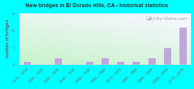
- New bridges - historical statistics
- 11910-1919
- 21930-1939
- 11950-1959
- 21960-1969
- 11970-1979
- 11980-1989
- 21990-1999
- 52000-2009
- 112010-2019

- Reconstructed bridges - Historical Statistics
- 11960-1969
- 01970-1979
- 01980-1989
- 01990-1999
- 22000-2009


- Bridge Condition - Deck
- 47.1%Good
- 47.1%Fair
- 5.9%Poor

- Bridge Condition - Superstructure
- 83.3%Good
- 16.7%Fair

- Bridge Condition - Substructure
- 83.3%Good
- 16.7%Fair

- Bridge Condition - Channel
- 33.3%Very good
- 41.7%Good
- 16.7%Satisfactory
- 8.3%Fair
Find on map >> Show street view
Structure Number: 25 0072, Location: 03-ED-050-R1.66 (Lat: 38.657206, Lng: -121.057158), Route carried "on" structure: US 50, Year Built: 1965, Year Reconstructed: 2009, Status: Open, Structure Length: 3.35m (10.99ft), Average Daily Traffic: 95,000 (year 2012), Truck Traffic: 6%, Average Future Daily Traffic: 159,000 (year 2037), Design Load: HL 93, Features Intersected: OLD SILVA VALLEY PARKWAY
Minimum Vertical Clearance: 30+ m (98+ ft), Kilometerpoint: 1.660, Lanes on structure: 6, Lanes under structure: 2, Base Highway Network: Yes (, Subroute: 1), Owner: State Highway Agency, Approaching Roadway Width: 41.4m (135.8ft), Skew: 30 degrees, Material/Design: Concrete continuous, Design/Construction: Tee Beam, Number Of Spans In Main Unit: 3, Length of Maximum Span: 14.6m (47.9ft), Curb-To-Curb Width: 40.5m (132.9ft), Out-to-Out Width: 41.4m (135.8ft)
Condition: Deck: Fair, Superstructure: Good, Substructure: Good, Operating Rating: 33.4 metric tons, Method Used To Determine Operating Rating: Load and Resistance Factor Rating (LRFR) rating reported by rating factor(RF) method using HL-93 loadings, Inventory Rating: 25.6 metric tons, Method Used To Determine Inventory Rating: Load and Resistance Factor Rating (LRFR) rating reported by rating factor(RF) method using HL-93 loadings, Structural Evaluation: Equal to present minimum criteria, Deck Geometry: Superior to present desirable criteria, Underclear: Meets minimum limits, Approach Roadway Alignment: Equal to present desirable criteria, Designated Inspection Frequency: Every 24 months, Inspection Date: September 2020, Deck Structure Type: Concrete Cast-file-Place
Find on map >> Show street view
Structure Number: 25 0072K, Location: 03-ED-050-R1.65 (Lat: 38.657597, Lng: -121.057372), Route carried "on" structure: Ramp US 50, Year Built: 2015, Status: Open, Structure Length: 3.52m (11.55ft), Average Daily Traffic: 10,000 (year 2015), Truck Traffic: 6%, Average Future Daily Traffic: 14,378 (year 2042), Design Load: HL 93, Features Intersected: OLD SILVA VALLEY PARKWAY
Minimum Vertical Clearance: 30+ m (98+ ft), Kilometerpoint: 1.650, Lanes on structure: 2, Lanes under structure: 2, Owner: State Highway Agency, Approaching Roadway Width: 11.0m (36.1ft), Material/Design: Prestressed concrete continuous, Design/Construction: Slab, Number Of Spans In Main Unit: 3, Length of Maximum Span: 14.8m (48.6ft), Curb-To-Curb Width: 11.0m (36.1ft), Out-to-Out Width: 11.9m (39.0ft)
Condition: Deck: Good, Superstructure: Good, Substructure: Good, Operating Rating: 42.1 metric tons, Method Used To Determine Operating Rating: Assigned ratings based on Load and Resistance Factor Design (LRFD) reported by rating factor (RF) using HL93 loadings, Inventory Rating: 32.4 metric tons, Method Used To Determine Inventory Rating: Assigned ratings based on Load and Resistance Factor Design (LRFD) reported by rating factor (RF) using HL93 loadings, Structural Evaluation: Better than present minimum criteria, Deck Geometry: Better than present minimum criteria, Underclear: High priority of corrective action, Approach Roadway Alignment: Equal to present desirable criteria, Designated Inspection Frequency: Every 48 months, Inspection Date: September 2020, Deck Structure Type: Concrete Cast-file-Place
Find on map >> Show street view
Structure Number: 25 0072S, Location: 03-ED-050-R1.66 (Lat: 38.656994, Lng: -121.057028), Route carried "on" structure: US 50, Year Built: 2015, Status: Open, Structure Length: 3.89m (12.76ft), Average Daily Traffic: 10,000 (year 2015), Truck Traffic: 6%, Average Future Daily Traffic: 15,000 (year 2037), Design Load: HL 93, Features Intersected: OLD SILVA VALLEY PARKWAY
Minimum Vertical Clearance: 30+ m (98+ ft), Kilometerpoint: 1.660, Lanes on structure: 2, Lanes under structure: 2, Base Highway Network: Yes, Owner: State Highway Agency, Approaching Roadway Width: 11.0m (36.1ft), Skew: 2 degrees, Material/Design: Prestressed concrete, Design/Construction: Box Beam or Girders - Multiple, Number Of Spans In Main Unit: 1, Length of Maximum Span: 37.9m (124.3ft), Curb-To-Curb Width: 11.0m (36.1ft), Out-to-Out Width: 11.9m (39.0ft)
Condition: Deck: Fair, Superstructure: Good, Substructure: Good, Operating Rating: 42.1 metric tons, Method Used To Determine Operating Rating: Assigned ratings based on Load and Resistance Factor Design (LRFD) reported by rating factor (RF) using HL93 loadings, Inventory Rating: 32.4 metric tons, Method Used To Determine Inventory Rating: Assigned ratings based on Load and Resistance Factor Design (LRFD) reported by rating factor (RF) using HL93 loadings, Structural Evaluation: Better than present minimum criteria, Deck Geometry: Somewhat better than minimum adequacy, Underclear: Meets minimum limits, Approach Roadway Alignment: Equal to present desirable criteria, Designated Inspection Frequency: Every 24 months, Inspection Date: September 2020, Deck Structure Type: Concrete Cast-file-Place
Find on map >> Show street view
Structure Number: 25 0073, Location: 03-ED-050-R3.24 (Lat: 38.655356, Lng: -121.030011), Route carried "on" structure: US 50, Year Built: 1966, Year Reconstructed: 2013, Status: Open, Structure Length: 3.78m (12.40ft), Average Daily Traffic: 60,000 (year 2009), Truck Traffic: 6%, Average Future Daily Traffic: 105,000 (year 2037), Design Load: HL 93, Features Intersected: BASS LAKE ROAD
Minimum Vertical Clearance: 30+ m (98+ ft), Kilometerpoint: 3.240, Lanes on structure: 6, Lanes under structure: 2, Base Highway Network: Yes (, Subroute: 1), Owner: State Highway Agency, Approaching Roadway Width: 33.9m (111.2ft), Skew: 30 degrees, Material/Design: Concrete continuous, Design/Construction: Tee Beam, Number Of Spans In Main Unit: 3, Length of Maximum Span: 14.6m (47.9ft), Curb-To-Curb Width: 33.9m (111.2ft), Out-to-Out Width: 35.5m (116.5ft)
Condition: Deck: Good, Superstructure: Good, Substructure: Good, Operating Rating: 37.9 metric tons, Method Used To Determine Operating Rating: Load and Resistance Factor Rating (LRFR) rating reported by rating factor(RF) method using HL-93 loadings, Inventory Rating: 26.9 metric tons, Method Used To Determine Inventory Rating: Load and Resistance Factor Rating (LRFR) rating reported by rating factor(RF) method using HL-93 loadings, Structural Evaluation: Equal to present minimum criteria, Deck Geometry: Superior to present desirable criteria, Underclear: High priority of corrective action, Approach Roadway Alignment: Equal to present desirable criteria, Designated Inspection Frequency: Every 24 months, Inspection Date: September 2020, Deck Structure Type: Concrete Cast-file-Place, Wearing Surface/Protective System: Wearing Surface: Bituminous
Find on map >> Show street view
Structure Number: 25 0079, Location: 03-ED-050-R1.90L (Lat: 38.658025, Lng: -121.052900), Route carried "on" structure: US 50, Year Built: 1939, Year Reconstructed: 1965, Status: Open, Structure Length: 1.07m (3.51ft), Average Daily Traffic: 72,000 (year 2012), Truck Traffic: 6%, Average Future Daily Traffic: 119,000 (year 2037), Features Intersected: CARSON CREEK
Minimum Vertical Clearance: 30+ m (98+ ft), Kilometerpoint: 1.900, Lanes on structure: 6, Base Highway Network: Yes (, Subroute: 1), Owner: State Highway Agency, Approaching Roadway Width: 50.2m (164.7ft), Material/Design: Concrete continuous, Design/Construction: Culvert, Number Of Spans In Main Unit: 3, Length of Maximum Span: 3.0m (9.8ft)
Condition: Channel: Satisfactory, Culverts: Good, Operating Rating: 40.5 metric tons, Method Used To Determine Operating Rating: Field evaluation and documented engineering judgment, Inventory Rating: 24.3 metric tons, Method Used To Determine Inventory Rating: Field evaluation and documented engineering judgment, Structural Evaluation: Equal to present minimum criteria, Waterway Adequacy: Equal to present desirable criteria, Approach Roadway Alignment: Equal to present desirable criteria, Designated Inspection Frequency: Every 24 months, Inspection Date: September 2020
Find on map >> Show street view
Structure Number: 25 0122, Location: 03-ED-050-0.86 (Lat: 38.652650, Lng: -121.070858), Route carried "on" structure: US 50, Year Built: 2009, Status: Open, Structure Length: 6.16m (20.21ft), Average Daily Traffic: 72,000 (year 2009), Truck Traffic: 6%, Average Future Daily Traffic: 122,828 (year 2042), Design Load: HL 93, Features Intersected: LATROBE ROAD
Minimum Vertical Clearance: 30+ m (98+ ft), Kilometerpoint: 0.860, Lanes on structure: 2, Lanes under structure: 8, Base Highway Network: Yes (, Subroute: 1), Owner: State Highway Agency, Approaching Roadway Width: 45.7m (149.9ft), Skew: 30 degrees, Material/Design: Prestressed concrete, Design/Construction: Box Beam or Girders - Single/Spread, Number Of Spans In Main Unit: 2, Length of Maximum Span: 30.1m (98.8ft), Curb-To-Curb Width: 41.5m (136.2ft), Out-to-Out Width: 43.0m (141.1ft)
Condition: Deck: Poor, Superstructure: Good, Substructure: Good, Operating Rating: 42.1 metric tons, Method Used To Determine Operating Rating: Assigned ratings based on Load and Resistance Factor Design (LRFD) reported by rating factor (RF) using HL93 loadings, Inventory Rating: 32.4 metric tons, Method Used To Determine Inventory Rating: Assigned ratings based on Load and Resistance Factor Design (LRFD) reported by rating factor (RF) using HL93 loadings, Structural Evaluation: Better than present minimum criteria, Deck Geometry: Superior to present desirable criteria, Underclear: Better than present minimum criteria, Approach Roadway Alignment: Equal to present desirable criteria, Length Of Structure Improvement: 6.16m (20.21ft), Designated Inspection Frequency: Every 24 months, Inspection Date: September 2020, Bridge Improvement Cost: $2,619,000, Roadway Improvement Cost: $523,000, Total Project Cost: $4,399,000 ( Estimate for 2021), Deck Structure Type: Concrete Cast-file-Place
Find on map >> Show street view
Structure Number: 25 0122K, Location: 03-ED-050-0.85 (Lat: 38.653078, Lng: -121.071097), Route carried "on" structure: Ramp US 50, Year Built: 2013, Status: Open, Structure Length: 6.16m (20.21ft), Average Daily Traffic: 12,000 (year 2012), Truck Traffic: 6%, Average Future Daily Traffic: 15,500 (year 2037), Design Load: HL 93, Features Intersected: LATROBE ROAD
Minimum Vertical Clearance: 30+ m (98+ ft), Kilometerpoint: 0.850, Lanes on structure: 2, Lanes under structure: 8, Base Highway Network: Yes (Inventory Route: 50, Subroute: 2), Owner: State Highway Agency, Approaching Roadway Width: 11.0m (36.1ft), Material/Design: Prestressed concrete, Design/Construction: Box Beam or Girders - Single/Spread, Number Of Spans In Main Unit: 2, Length of Maximum Span: 30.1m (98.8ft), Curb-To-Curb Width: 11.0m (36.1ft), Out-to-Out Width: 11.9m (39.0ft)
Condition: Deck: Fair, Superstructure: Good, Substructure: Good, Operating Rating: 42.1 metric tons, Method Used To Determine Operating Rating: Assigned ratings based on Load and Resistance Factor Design (LRFD) reported by rating factor (RF) using HL93 loadings, Inventory Rating: 32.4 metric tons, Method Used To Determine Inventory Rating: Assigned ratings based on Load and Resistance Factor Design (LRFD) reported by rating factor (RF) using HL93 loadings, Structural Evaluation: Better than present minimum criteria, Deck Geometry: Better than present minimum criteria, Underclear: Better than present minimum criteria, Approach Roadway Alignment: Equal to present desirable criteria, Designated Inspection Frequency: Every 24 months, Inspection Date: September 2020, Deck Structure Type: Concrete Cast-file-Place
Find on map >> Show street view
Structure Number: 25 0122S, Location: 03-ED-050-0.86 (Lat: 38.652483, Lng: -121.070772), Route carried "on" structure: US 50, Year Built: 2009, Status: Open, Structure Length: 6.16m (20.21ft), Average Daily Traffic: 12,000 (year 2012), Truck Traffic: 6%, Average Future Daily Traffic: 15,500 (year 2037), Design Load: HL 93, Features Intersected: LATROBE ROAD
Minimum Vertical Clearance: 30+ m (98+ ft), Kilometerpoint: 0.860, Lanes on structure: 1, Lanes under structure: 8, Base Highway Network: Yes (, Subroute: 1), Owner: State Highway Agency, Approaching Roadway Width: 11.0m (36.1ft), Material/Design: Prestressed concrete, Design/Construction: Box Beam or Girders - Single/Spread, Number Of Spans In Main Unit: 2, Length of Maximum Span: 30.1m (98.8ft), Curb-To-Curb Width: 11.0m (36.1ft), Out-to-Out Width: 11.9m (39.0ft)
Condition: Deck: Fair, Superstructure: Good, Substructure: Good, Operating Rating: 42.1 metric tons, Method Used To Determine Operating Rating: Assigned ratings based on Load and Resistance Factor Design (LRFD) reported by rating factor (RF) using HL93 loadings, Inventory Rating: 32.4 metric tons, Method Used To Determine Inventory Rating: Assigned ratings based on Load and Resistance Factor Design (LRFD) reported by rating factor (RF) using HL93 loadings, Structural Evaluation: Better than present minimum criteria, Deck Geometry: Meets minimum limits, Underclear: Superior to present desirable criteria, Approach Roadway Alignment: Equal to present desirable criteria, Designated Inspection Frequency: Every 24 months, Inspection Date: September 2020, Deck Structure Type: Concrete Cast-file-Place
Find on map >> Show street view
Structure Number: 25 0127, Location: 03-ED-050-R1.81L (Lat: 38.658278, Lng: -121.054519), Route carried "on" structure: Business County highway , Year Built: 2015, Status: Open, Structure Length: 8.50m (27.89ft), Average Daily Traffic: 10,000 (year 2015), Truck Traffic: 6%, Average Future Daily Traffic: 15,000 (year 2037), Design Load: HL 93, Features Intersected: US 50, Facility Carried by Structure: SILVA PARKWAY
Minimum Vertical Clearance: 30+ m (98+ ft), Kilometerpoint: 0.000, Lanes on structure: 6, Lanes under structure: 7, Owner: State Highway Agency, Approaching Roadway Width: 27.7m (90.9ft), Skew: 30 degrees, Material/Design: Prestressed concrete continuous, Design/Construction: Box Beam or Girders - Multiple, Number Of Spans In Main Unit: 2, Length of Maximum Span: 42.7m (140.1ft), Curb-To-Curb Width: 27.7m (90.9ft), Out-to-Out Width: 30.5m (100.1ft)
Condition: Deck: Good, Superstructure: Good, Substructure: Good, Operating Rating: 42.1 metric tons, Method Used To Determine Operating Rating: Assigned ratings based on Load and Resistance Factor Design (LRFD) reported by rating factor (RF) using HL93 loadings, Inventory Rating: 32.4 metric tons, Method Used To Determine Inventory Rating: Assigned ratings based on Load and Resistance Factor Design (LRFD) reported by rating factor (RF) using HL93 loadings, Structural Evaluation: Better than present minimum criteria, Deck Geometry: Equal to present desirable criteria, Underclear: High priority of corrective action, Approach Roadway Alignment: Equal to present desirable criteria, Designated Inspection Frequency: Every 24 months, Inspection Date: September 2020, Deck Structure Type: Concrete Cast-file-Place
Find on map >> Show street view
Structure Number: 25 0130K, Location: 03-ED-050-R1.90L (Lat: 38.659306, Lng: -121.053306), Route carried "on" structure: Ramp US 50, Year Built: 2015, Status: Open, Structure Length: 7.83m (25.69ft), Average Daily Traffic: 4,000 (year 2015), Truck Traffic: 6%, Average Future Daily Traffic: 6,400 (year 2037), Design Load: HL 93, Features Intersected: CARSON CREEK
Minimum Vertical Clearance: 30+ m (98+ ft), Kilometerpoint: 1.900, Lanes on structure: 3, Owner: State Highway Agency, Approaching Roadway Width: 14.6m (47.9ft), Material/Design: Concrete continuous, Design/Construction: Box Beam or Girders - Multiple, Number Of Spans In Main Unit: 3, Length of Maximum Span: 31.1m (102.0ft), Curb-To-Curb Width: 14.6m (47.9ft), Out-to-Out Width: 15.5m (50.9ft)
Condition: Deck: Fair, Superstructure: Good, Substructure: Good, Channel: Good, Operating Rating: 42.1 metric tons, Method Used To Determine Operating Rating: Assigned ratings based on Load and Resistance Factor Design (LRFD) reported by rating factor (RF) using HL93 loadings, Inventory Rating: 32.4 metric tons, Method Used To Determine Inventory Rating: Assigned ratings based on Load and Resistance Factor Design (LRFD) reported by rating factor (RF) using HL93 loadings, Structural Evaluation: Better than present minimum criteria, Deck Geometry: Better than present minimum criteria, Waterway Adequacy: Equal to present desirable criteria, Approach Roadway Alignment: Equal to present desirable criteria, Designated Inspection Frequency: Every 24 months, Inspection Date: September 2020, Deck Structure Type: Concrete Cast-file-Place
Find on map >> Show street view
Structure Number: 25C0035, Location: 4.6 MI SOUTH U.S. 50 (Lat: 38.600269, Lng: -121.022536), Route carried "on" structure: County highway , Year Built: 1987, Status: Open, Structure Length: 7.01m (23.00ft), Average Daily Traffic: 4,879 (year 2013), Truck Traffic: 10%, Average Future Daily Traffic: 6,471 (year 2042), Design Load: HS 20+Mod, Features Intersected: DEER CREEK, Facility Carried by Structure: LATROBE RD
Minimum Vertical Clearance: 30+ m (98+ ft), Kilometerpoint: 0.000, Lanes on structure: 2, Owner: County Highway Agency, Approaching Roadway Width: 12.2m (40.0ft), Skew: 4 degrees, Material/Design: Concrete continuous, Design/Construction: Slab, Number Of Spans In Main Unit: 7, Length of Maximum Span: 10.4m (34.1ft), Curb-To-Curb Width: 12.2m (40.0ft), Out-to-Out Width: 12.4m (40.7ft)
Condition: Deck: Good, Superstructure: Good, Substructure: Good, Channel: Good, Operating Rating: 54.1 metric tons, Method Used To Determine Operating Rating: Assigned rating based on Load Factor Design (LFD) reported in metric tons, Inventory Rating: 32.4 metric tons, Method Used To Determine Inventory Rating: Assigned rating based on Load Factor Design (LFD) reported in metric tons, Structural Evaluation: Better than present minimum criteria, Deck Geometry: Equal to present minimum criteria, Waterway Adequacy: Better than present minimum criteria, Approach Roadway Alignment: Equal to present desirable criteria, Designated Inspection Frequency: Every 24 months, Inspection Date: June 2020, Deck Structure Type: Concrete Cast-file-Place
Find on map >> Show street view
Structure Number: 25C0036, Location: 1.2 MI N GREEN VALLEY RD (Lat: 38.724025, Lng: -121.071461), Route carried "on" structure: County highway , Year Built: 1975, Status: Open, Structure Length: 2.53m (8.30ft), Average Daily Traffic: 2,239 (year 2012), Truck Traffic: 10%, Average Future Daily Traffic: 4,304 (year 2040), Features Intersected: NEW YORK CREEK, Facility Carried by Structure: SALMON FALLS RD
Minimum Vertical Clearance: 30+ m (98+ ft), Kilometerpoint: 0.000, Lanes on structure: 2, Base Highway Network: Yes, Owner: County Highway Agency, Approaching Roadway Width: 11.0m (36.1ft), Skew: 5 degrees, Material/Design: Concrete continuous, Design/Construction: Slab, Number Of Spans In Main Unit: 2, Length of Maximum Span: 12.5m (41.0ft), Curb-To-Curb Width: 9.7m (31.8ft), Out-to-Out Width: 9.9m (32.5ft)
Condition: Deck: Fair, Superstructure: Fair, Substructure: Good, Channel: Good, Operating Rating: 86.2 metric tons, Method Used To Determine Operating Rating: Load Factor (LF), Inventory Rating: 51.8 metric tons, Method Used To Determine Inventory Rating: Load Factor (LF), Structural Evaluation: Somewhat better than minimum adequacy, Deck Geometry: Meets minimum limits, Waterway Adequacy: Better than present minimum criteria, Approach Roadway Alignment: Equal to present minimum criteria, Designated Inspection Frequency: Every 24 months, Inspection Date: July 2020, Deck Structure Type: Concrete Cast-file-Place
Find on map >> Show street view
Structure Number: 25C0037, Location: 4.5 MI S PILOT HILL (Lat: 38.772708, Lng: -121.037522), Route carried "on" structure: County highway , Year Built: 1953, Status: Open, Structure Length: 15.54m (50.98ft), Average Daily Traffic: 1,900 (year 2012), Truck Traffic: 10%, Average Future Daily Traffic: 4,304 (year 2040), Design Load: H 15, Features Intersected: SOUTH FK AMERICAN RIVER, Facility Carried by Structure: SALMON FALLS RD
Minimum Vertical Clearance: 4.54m (14.90ft), Kilometerpoint: 0.000, Lanes on structure: 2, Base Highway Network: Yes, Owner: County Highway Agency, Approaching Roadway Width: 7.3m (24.0ft), Skew: 3 degrees, Material/Design: Steel, Design/Construction: Truss - Thru, Number Of Spans In Main Unit: 1, Number Of Approach Spans: 4, Length of Maximum Span: 69.5m (228.0ft), Curb or Sidewalk Widths: Left: 0.3m (1.0ft), Right: 0.3m (1.0ft), Curb-To-Curb Width: 7.3m (24.0ft), Out-to-Out Width: 9.0m (29.5ft)
Condition: Deck: Good, Superstructure: Good, Substructure: Fair, Channel: Good, Operating Rating: 29.5 metric tons, Method Used To Determine Operating Rating: Allowable Stress (AS), Inventory Rating: 18.5 metric tons, Method Used To Determine Inventory Rating: Allowable Stress (AS), Structural Evaluation: Somewhat better than minimum adequacy, Deck Geometry: Meets minimum limits, Waterway Adequacy: Superior to present desirable criteria, Approach Roadway Alignment: Equal to present minimum criteria, Designated Inspection Frequency: Every 24 months, Critical Feature Inspection Frequency: Every 24 months, Inspection Date: July 2020, Critical Feature Inspection Date: April 2020, Deck Structure Type: Concrete Cast-file-Place
Find on map >> Show street view
Structure Number: 25C0095, Location: 0.2 MI E SALMON FALLS RD (Lat: 38.712256, Lng: -121.075303), Route carried "on" structure: County highway , Year Built: 1932, Status: Open, Structure Length: 1.13m (3.71ft), Average Daily Traffic: 963 (year 2009), Truck Traffic: 4%, Average Future Daily Traffic: 2,130 (year 2040), Features Intersected: NEW YORK CREEK, Facility Carried by Structure: MALCOLM-DIXON ROAD
Minimum Vertical Clearance: 30+ m (98+ ft), Kilometerpoint: 0.000, Lanes on structure: 2, Owner: County Highway Agency, Approaching Roadway Width: 5.8m (19.0ft), Material/Design: Concrete, Design/Construction: Stringer/Multi-beam, Number Of Spans In Main Unit: 1, Length of Maximum Span: 10.7m (35.1ft), Curb or Sidewalk Widths: Left: 0.1m (0.3ft), Right: 0.1m (0.3ft), Curb-To-Curb Width: 5.8m (19.0ft), Out-to-Out Width: 7.2m (23.6ft)
Condition: Deck: Good, Superstructure: Fair, Substructure: Fair, Channel: Fair, Operating Rating: 25.6 metric tons, Method Used To Determine Operating Rating: Field evaluation and documented engineering judgment, Inventory Rating: 15.6 metric tons, Method Used To Determine Inventory Rating: Field evaluation and documented engineering judgment, Structural Evaluation: Meets minimum limits, Deck Geometry: High priority of replacement, Waterway Adequacy: Equal to present desirable criteria, Approach Roadway Alignment: Equal to present minimum criteria, Designated Inspection Frequency: Every 24 months, Inspection Date: July 2020, Deck Structure Type: Concrete Cast-file-Place, Wearing Surface/Protective System: Wearing Surface: Bituminous
Find on map >> Show street view
Structure Number: 25C0112, Location: 1.1 MI E OF LATROBE RD (Lat: 38.654944, Lng: -121.052686), Route carried "on" structure: County highway , Year Built: 1918, Status: Open, Structure Length: 1.58m (5.18ft), Average Daily Traffic: 100 (year 2011), Truck Traffic: 10%, Average Future Daily Traffic: 319 (year 2040), Features Intersected: CARSON CREEK, Facility Carried by Structure: OLD WHITE ROCK RD
Minimum Vertical Clearance: 30+ m (98+ ft), Kilometerpoint: 0.000, Lanes on structure: 2, Owner: County Highway Agency, Approaching Roadway Width: 5.5m (18.0ft), Material/Design: Concrete continuous, Design/Construction: Slab, Number Of Spans In Main Unit: 3, Length of Maximum Span: 5.2m (17.1ft), Curb or Sidewalk Widths: Left: 0.2m (0.7ft), Right: 0.2m (0.7ft), Curb-To-Curb Width: 6.4m (21.0ft), Out-to-Out Width: 7.2m (23.6ft)
Condition: Deck: Fair, Superstructure: Fair, Substructure: Good, Channel: Good, Operating Rating: 26.9 metric tons, Method Used To Determine Operating Rating: Field evaluation and documented engineering judgment, Inventory Rating: 16.2 metric tons, Method Used To Determine Inventory Rating: Field evaluation and documented engineering judgment, Structural Evaluation: Somewhat better than minimum adequacy, Deck Geometry: Somewhat better than minimum adequacy, Waterway Adequacy: Equal to present desirable criteria, Approach Roadway Alignment: Equal to present desirable criteria, Designated Inspection Frequency: Every 24 months, Inspection Date: June 2020, Deck Structure Type: Concrete Cast-file-Place, Wearing Surface/Protective System: Wearing Surface: Bituminous
Find on map >> Show street view
Structure Number: 25C0123, Location: EAST OF ED HILLS BLVD. (Lat: 38.674117, Lng: -121.059939), Route carried "on" structure: County highway , Year Built: 1998, Status: Open, Structure Length: 2.22m (7.28ft), Average Daily Traffic: 5,414 (year 2013), Truck Traffic: 4%, Average Future Daily Traffic: 2,636 (year 2040), Design Load: HS 20+Mod, Features Intersected: ALLEGHENY CREEK, Facility Carried by Structure: SERRANO PKWAY WEST
Minimum Vertical Clearance: 30+ m (98+ ft), Kilometerpoint: 0.000, Lanes on structure: 2, Owner: County Highway Agency, Approaching Roadway Width: 11.5m (37.7ft), Skew: 3 degrees, Material/Design: Prestressed concrete, Design/Construction: Box Beam or Girders - Multiple, Number Of Spans In Main Unit: 1, Length of Maximum Span: 21.3m (69.9ft), Curb-To-Curb Width: 11.5m (37.7ft), Out-to-Out Width: 12.1m (39.7ft)
Condition: Deck: Fair, Superstructure: Good, Substructure: Good, Channel: Very good, Operating Rating: 54.1 metric tons, Method Used To Determine Operating Rating: Assigned rating based on Load Factor Design (LFD) reported in metric tons, Inventory Rating: 32.4 metric tons, Method Used To Determine Inventory Rating: Assigned rating based on Load Factor Design (LFD) reported in metric tons, Structural Evaluation: Better than present minimum criteria, Deck Geometry: Equal to present minimum criteria, Waterway Adequacy: Better than present minimum criteria, Approach Roadway Alignment: Equal to present desirable criteria, Designated Inspection Frequency: Every 24 months, Inspection Date: June 2020, Deck Structure Type: Concrete Cast-file-Place
Find on map >> Show street view
Structure Number: 25C0124, Location: EAST OF ED HILLS BLVD. (Lat: 38.675031, Lng: -121.057658), Route carried "on" structure: County highway , Year Built: 1998, Status: Open, Structure Length: 1.26m (4.13ft), Average Daily Traffic: 6,200 (year 2013), Truck Traffic: 4%, Average Future Daily Traffic: 2,636 (year 2040), Design Load: HS 20+Mod, Features Intersected: ALLEGHENY CREEK, Facility Carried by Structure: SERRANO PKWAY EAST
Minimum Vertical Clearance: 30+ m (98+ ft), Kilometerpoint: 0.000, Lanes on structure: 2, Owner: County Highway Agency, Approaching Roadway Width: 11.5m (37.7ft), Material/Design: Concrete, Design/Construction: Slab, Number Of Spans In Main Unit: 1, Length of Maximum Span: 11.3m (37.1ft), Curb-To-Curb Width: 11.5m (37.7ft), Out-to-Out Width: 12.2m (40.0ft)
Condition: Deck: Good, Superstructure: Good, Substructure: Good, Channel: Very good, Operating Rating: 54.1 metric tons, Method Used To Determine Operating Rating: Assigned rating based on Load Factor Design (LFD) reported in metric tons, Inventory Rating: 32.4 metric tons, Method Used To Determine Inventory Rating: Assigned rating based on Load Factor Design (LFD) reported in metric tons, Structural Evaluation: Better than present minimum criteria, Deck Geometry: Equal to present minimum criteria, Waterway Adequacy: Better than present minimum criteria, Approach Roadway Alignment: Equal to present desirable criteria, Designated Inspection Frequency: Every 48 months, Inspection Date: June 2018, Deck Structure Type: Concrete Cast-file-Place
Find on map >> Show street view
Structure Number: 25C0127, Location: W OF CARSON CRK RESERVOIR (Lat: 38.635519, Lng: -121.060944), Route carried "on" structure: County highway , Year Built: 2009, Status: Open, Structure Length: 3.00m (9.84ft), Average Daily Traffic: 4,879 (year 2013), Truck Traffic: 10%, Average Future Daily Traffic: 6,471 (year 2042), Design Load: HS 20+Mod, Features Intersected: CARSON CREEK, Facility Carried by Structure: LATROBE ROAD
Minimum Vertical Clearance: 30+ m (98+ ft), Kilometerpoint: 0.000, Lanes on structure: 2, Owner: County Highway Agency, Approaching Roadway Width: 25.2m (82.7ft), Skew: 4 degrees, Material/Design: Prestressed concrete, Design/Construction: Box Beam or Girders - Multiple, Number Of Spans In Main Unit: 1, Length of Maximum Span: 30.0m (98.4ft), Curb-To-Curb Width: 25.2m (82.7ft), Out-to-Out Width: 26.3m (86.3ft)
Condition: Deck: Good, Superstructure: Good, Substructure: Fair, Channel: Satisfactory, Operating Rating: 54.1 metric tons, Method Used To Determine Operating Rating: Assigned rating based on Load Factor Design (LFD) reported in metric tons, Inventory Rating: 32.4 metric tons, Method Used To Determine Inventory Rating: Assigned rating based on Load Factor Design (LFD) reported in metric tons, Structural Evaluation: Somewhat better than minimum adequacy, Deck Geometry: Superior to present desirable criteria, Waterway Adequacy: Equal to present desirable criteria, Approach Roadway Alignment: Equal to present desirable criteria, Designated Inspection Frequency: Every 24 months, Inspection Date: June 2020, Deck Structure Type: Concrete Cast-file-Place
Find on map >> Show street view
Structure Number: 25C0142, Location: 0.9 MI E/O LATROBE ROAD (Lat: 38.653572, Lng: -121.055819), Route carried "on" structure: County highway , Year Built: 2014, Status: Open, Structure Length: 3.62m (11.88ft), Average Daily Traffic: 9,442 (year 2012), Truck Traffic: 2%, Average Future Daily Traffic: 13,306 (year 2040), Features Intersected: BUCKS RAVINE CREEK, Facility Carried by Structure: WHITE ROCK ROAD
Minimum Vertical Clearance: 30+ m (98+ ft), Kilometerpoint: 0.000, Lanes on structure: 5, Owner: County Highway Agency, Approaching Roadway Width: 23.5m (77.1ft), Skew: 34 degrees, Material/Design: Concrete continuous, Design/Construction: Culvert, Number Of Spans In Main Unit: 4, Length of Maximum Span: 2.5m (8.2ft), Curb-To-Curb Width: 23.5m (77.1ft), Out-to-Out Width: 37.4m (122.7ft)
Condition: Channel: Very good, Culverts: Good, Operating Rating: 54.1 metric tons, Method Used To Determine Operating Rating: Field evaluation and documented engineering judgment, Inventory Rating: 32.4 metric tons, Method Used To Determine Inventory Rating: Field evaluation and documented engineering judgment, Structural Evaluation: Better than present minimum criteria, Deck Geometry: Better than present minimum criteria, Waterway Adequacy: Better than present minimum criteria, Approach Roadway Alignment: Equal to present desirable criteria, Designated Inspection Frequency: Every 48 months, Inspection Date: June 2018
Find on map >> Show street view
Structure Number: 25C0143, Location: 0.2 MI E/O SILVA VLY PKWY (Lat: 38.660019, Lng: -121.052133), Route carried "on" structure: Spur County highway , Year Built: 2014, Status: Open, Structure Length: 1.10m (3.61ft), Average Daily Traffic: 400 (year 2016), Truck Traffic: 1%, Average Future Daily Traffic: 500 (year 2036), Features Intersected: CARSON CREEK, Facility Carried by Structure: TONG ROAD
Minimum Vertical Clearance: 30+ m (98+ ft), Kilometerpoint: 0.000, Lanes on structure: 2, Owner: County Highway Agency, Approaching Roadway Width: 9.8m (32.2ft), Skew: 4 degrees, Material/Design: Concrete, Design/Construction: Arch - Deck, Number Of Spans In Main Unit: 1, Length of Maximum Span: 11.0m (36.1ft), Curb-To-Curb Width: 9.8m (32.2ft), Out-to-Out Width: 9.8m (32.2ft)
Condition: Superstructure: Good, Substructure: Good, Channel: Very good, Operating Rating: 54.0 metric tons, Method Used To Determine Operating Rating: Field evaluation and documented engineering judgment, Inventory Rating: 32.4 metric tons, Method Used To Determine Inventory Rating: Field evaluation and documented engineering judgment, Structural Evaluation: Better than present minimum criteria, Deck Geometry: Better than present minimum criteria, Waterway Adequacy: Better than present minimum criteria, Approach Roadway Alignment: Equal to present desirable criteria, Designated Inspection Frequency: Every 48 months, Inspection Date: June 2018
Find on map >> Show street view
Structure Number: 25 0072K, Location: 03-ED-050-R1.65 (Lat: 38.657597, Lng: -121.057372), Route carried "under" structure: Business County highway , Year Built: 2015, Structure Length: 0. m, Average Daily Traffic: 8,000 (year 2015), Truck Traffic: 10%, Features Intersected: OLD SILVA VALLEY PARKWAY, Facility Carried by Structure: WB 50 ON-RAMP
Minimum Vertical Clearance: 4.75m (15.58ft), Kilometerpoint: 0.000, Lanes on structure: 2, Lanes under structure: 2, Material/Design: Prestressed concrete continuous, Design/Construction: Slab, Length of Maximum Span: 14.8m (48.6ft)
Find on map >> Show street view
Structure Number: 25 0072S, Location: 03-ED-050-R1.66 (Lat: 38.656994, Lng: -121.057028), Route carried "under" structure: Business County highway , Year Built: 2015, Structure Length: 0. m, Average Daily Traffic: 8,000 (year 2015), Truck Traffic: 10%, Features Intersected: OLD SILVA VALLEY PARKWAY, Facility Carried by Structure: EB 50 OFF-RAMP
Minimum Vertical Clearance: 5.94m (19.49ft), Kilometerpoint: 0.000, Lanes on structure: 2, Lanes under structure: 2, Material/Design: Prestressed concrete, Design/Construction: Box Beam or Girders - Multiple, Length of Maximum Span: 37.9m (124.3ft)
Find on map >> Show street view
Structure Number: 25 0122, Location: 03-ED-050-0.86 (Lat: 38.652650, Lng: -121.070858), Route carried "under" structure: County highway , Year Built: 2009, Structure Length: 0. m, Average Daily Traffic: 10,000 (year 2012), Truck Traffic: 5%, Features Intersected: LATROBE ROAD, Facility Carried by Structure: US HIGHWAY 50
Minimum Vertical Clearance: 4.74m (15.55ft), Kilometerpoint: 0.000, Lanes on structure: 2, Lanes under structure: 8, Material/Design: Prestressed concrete, Design/Construction: Box Beam or Girders - Single/Spread, Length of Maximum Span: 30.1m (98.8ft)
Find on map >> Show street view
Structure Number: 25 0122K, Location: 03-ED-050-0.85 (Lat: 38.653078, Lng: -121.071097), Route carried "under" structure: City street , Year Built: 2013, Structure Length: 0. m, Average Daily Traffic: 10,000 (year 2012), Truck Traffic: 5%, Features Intersected: LATROBE ROAD, Facility Carried by Structure: HWY 50
Minimum Vertical Clearance: 4.72m (15.49ft), Kilometerpoint: 0.000, Lanes on structure: 2, Lanes under structure: 8, Material/Design: Prestressed concrete, Design/Construction: Box Beam or Girders - Single/Spread, Length of Maximum Span: 30.1m (98.8ft)
Find on map >> Show street view
Structure Number: 25 0122S, Location: 03-ED-050-0.86 (Lat: 38.652483, Lng: -121.070772), Route carried "under" structure: County highway , Year Built: 2009, Structure Length: 0. m, Average Daily Traffic: 10,000 (year 2012), Truck Traffic: 5%, Features Intersected: LATROBE ROAD, Facility Carried by Structure: EB 50-NB LATROBE
Minimum Vertical Clearance: 5.11m (16.77ft), Kilometerpoint: 0.000, Lanes on structure: 1, Lanes under structure: 8, Material/Design: Prestressed concrete, Design/Construction: Box Beam or Girders - Single/Spread, Length of Maximum Span: 30.1m (98.8ft)
Find on map >> Show street view
Structure Number: 25 0127, Location: 03-ED-050-R1.81L (Lat: 38.658278, Lng: -121.054519), Route carried "under" structure: US 50, Year Built: 2015, Structure Length: 0. m, Average Daily Traffic: 72,000 (year 2009), Truck Traffic: 6%, Features Intersected: US 50, Facility Carried by Structure: SILVA PARKWAY
Minimum Vertical Clearance: 5.63m (18.47ft), Kilometerpoint: 1.810, Lanes on structure: 6, Lanes under structure: 7, Material/Design: Prestressed concrete continuous, Design/Construction: Box Beam or Girders - Multiple, Length of Maximum Span: 42.7m (140.1ft)