Bridge Statistics for Eatontown, New Jersey (NJ)
Condition, Traffic, Stress, Structural Evaluation, Project Costs
- National Bridge Inventory (NBI) Statistics
- 23Number of bridges
- 200ft / 61.1mTotal length
- $3,861,000Total costs
- 444,916Total average daily traffic
- 19,449Total average daily truck traffic
- National Bridge Inventory (NBI) Registered Bridges for Eatontown
- No street view available for this location
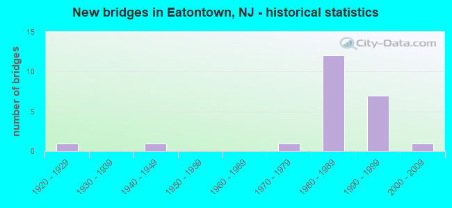
- New bridges - historical statistics
- 11920-1929
- 11940-1949
- 11970-1979
- 121980-1989
- 71990-1999
- 12000-2009
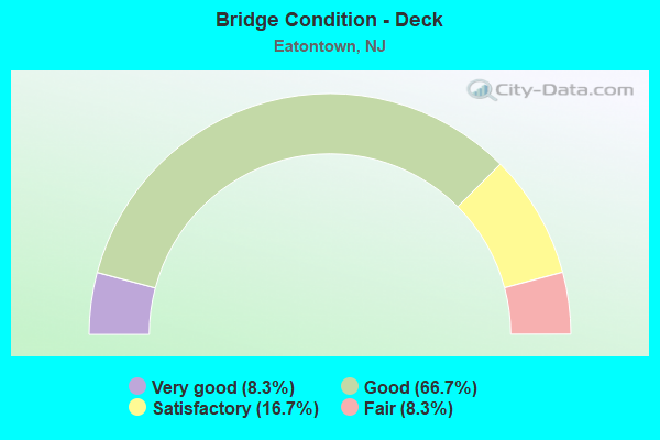
- Bridge Condition - Deck
- 8.3%Very good
- 66.7%Good
- 16.7%Satisfactory
- 8.3%Fair
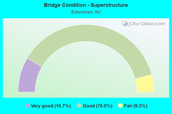
- Bridge Condition - Superstructure
- 16.7%Very good
- 75.0%Good
- 8.3%Fair

- Bridge Condition - Substructure
- 66.7%Good
- 16.7%Satisfactory
- 16.7%Fair
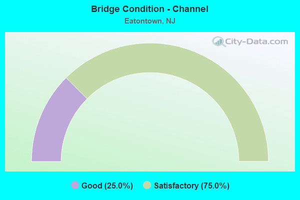
- Bridge Condition - Channel
- 25.0%Good
- 75.0%Satisfactory
Find on map >> Show street view
Structure Number: 13000E2, Location: 0.5 MI SW of NJ 35 (Lat: 40.301500, Lng: -74.067669), Route carried "on" structure: Other road , Year Built: 2009, Status: Open, Structure Length: 0.67m (2.20ft), Average Daily Traffic: 4,505 (year 2021), Truck Traffic: 1%, Average Future Daily Traffic: 5,497 (year 2041), Design Load: HS 25 or greater, Features Intersected: WAMPUM BROOK, Facility Carried by Structure: LEWIS STREET
Minimum Vertical Clearance: 30+ m (98+ ft), Kilometerpoint: 0.000, Lanes on structure: 2, Owner: County Highway Agency, Approaching Roadway Width: 9.1m (29.9ft), Skew: 2 degrees, Material/Design: Concrete, Design/Construction: Frame, Number Of Spans In Main Unit: 1, Length of Maximum Span: 6.7m (22.0ft), Curb or Sidewalk Widths: Left: 2.0m (6.6ft), Right: 0.2m (0.7ft), Curb-To-Curb Width: 9.4m (30.8ft), Out-to-Out Width: 12.0m (39.4ft)
Condition: Deck: Good, Superstructure: Good, Substructure: Good, Channel: Good, Operating Rating: 56.2 metric tons, Method Used To Determine Operating Rating: Load Factor (LF), Inventory Rating: 33.6 metric tons, Method Used To Determine Inventory Rating: Load Factor (LF), Structural Evaluation: Better than present minimum criteria, Deck Geometry: Meets minimum limits, Waterway Adequacy: Equal to present minimum criteria, Approach Roadway Alignment: Equal to present minimum criteria, Designated Inspection Frequency: Every 24 months, Underwater Inspection Frequency: Every 24 months, Inspection Date: May 2021, Underwater Inspection Date: September 2021, Deck Structure Type: Concrete Precast Panels, Wearing Surface/Protective System: Wearing Surface: Bituminous, Deck Protection: Galvanized Reinforcing
Find on map >> Show street view
Structure Number: 1300E2, Location: 5MI E. OF GSP INTCHG 115 (Lat: 40.310711, Lng: -74.005481), Route carried "on" structure: County highway 29, Year Built: 1944, Year Reconstructed: 1985, Status: Open, Structure Length: 6.55m (21.49ft), Average Daily Traffic: 8,445 (year 2021), Truck Traffic: 3%, Average Future Daily Traffic: 10,305 (year 2041), Design Load: HS 20+Mod, Features Intersected: BRANCHPORT CREEK
Minimum Vertical Clearance: 30+ m (98+ ft), Kilometerpoint: 1.416, Lanes on structure: 2, Owner: County Highway Agency, Approaching Roadway Width: 10.4m (34.1ft), Navigation Control: Yes ( Vertical Clearance: 1.5m (4.9ft), Horizontal Clearance: 4.6m (15.1ft)), Material/Design: Steel continuous, Design/Construction: Stringer/Multi-beam, Number Of Spans In Main Unit: 12, Length of Maximum Span: 5.8m (19.0ft), Curb or Sidewalk Widths: Left: 1.5m (4.9ft), Right: 0.6m (2.0ft), Curb-To-Curb Width: 9.1m (29.9ft), Out-to-Out Width: 11.3m (37.1ft)
Condition: Deck: Satisfactory, Superstructure: Good, Substructure: Fair, Channel: Satisfactory, Operating Rating: 39.9 metric tons, Method Used To Determine Operating Rating: Load Factor (LF), Inventory Rating: 23.6 metric tons, Method Used To Determine Inventory Rating: Load Factor (LF), Structural Evaluation: Somewhat better than minimum adequacy, Deck Geometry: Meets minimum limits, Waterway Adequacy: Equal to present minimum criteria, Approach Roadway Alignment: Equal to present desirable criteria, Designated Inspection Frequency: Every 24 months, Underwater Inspection Frequency: Every 48 months, Inspection Date: June 2021, Underwater Inspection Date: July 2019, Deck Structure Type: Concrete Cast-file-Place, Wearing Surface/Protective System: Wearing Surface: Latex Concrete
Find on map >> Show street view
Structure Number: 1300E24, Location: 0.35MI WEST OF NJ 35 (Lat: 40.305611, Lng: -74.068281), Route carried "on" structure: County highway 537, Year Built: 1928, Status: Posted for load, Structure Length: 1.86m (6.10ft), Average Daily Traffic: 7,785 (year 2021), Truck Traffic: 4%, Average Future Daily Traffic: 9,499 (year 2041), Features Intersected: NJ TRANSIT SOUTHERN DIVI
Minimum Vertical Clearance: 30+ m (98+ ft), Kilometerpoint: 103.272, Lanes on structure: 2, Owner: County Highway Agency, Approaching Roadway Width: 9.1m (29.9ft), Skew: 1 degrees, Material/Design: Steel, Design/Construction: Girder and Floorbeam System, Number Of Spans In Main Unit: 1, Length of Maximum Span: 17.7m (58.1ft), Curb or Sidewalk Widths: Left: 0.0m, Right: 1.4m (4.6ft), Curb-To-Curb Width: 9.2m (30.2ft), Out-to-Out Width: 10.4m (34.1ft)
Condition: Deck: Fair, Superstructure: Fair, Substructure: Fair, Operating Rating: 19.1 metric tons, Method Used To Determine Operating Rating: Load Factor (LF), Inventory Rating: 10.9 metric tons, Method Used To Determine Inventory Rating: Load Factor (LF), Structural Evaluation: High priority of replacement, Deck Geometry: High priority of corrective action, Underclear: High priority of replacement, Approach Roadway Alignment: Equal to present minimum criteria, Bridge Posting: Required (Relationship of Operating Rating to Maximum Legal Load: 10.0 - 19.9% below), Length Of Structure Improvement: 2.59m (8.50ft), Designated Inspection Frequency: Every 24 months, Critical Feature Inspection Frequency: Every 24 months, Other Special Inspection Frequency: Every 12 months, Inspection Date: May 2021, Critical Feature Inspection Date: May 2021, Other Special Inspection Date: May 2021, Bridge Improvement Cost: $1,618,000, Roadway Improvement Cost: $1,354,000, Total Project Cost: $3,861,000 ( Estimate for 2021), Deck Structure Type: Concrete Cast-file-Place, Wearing Surface/Protective System: Wearing Surface: Bituminous
Find on map >> Show street view
Structure Number: 1311155, Location: 1.2 MI S OF 35-36 JCT (Lat: 40.273331, Lng: -74.043331), Route carried "on" structure: State highway 35, Year Built: 1972, Status: Open, Structure Length: 0.82m (2.69ft), Average Daily Traffic: 36,496 (year 2021), Truck Traffic: 4%, Average Future Daily Traffic: 54,379 (year 2041), Design Load: HS 20+Mod, Features Intersected: WHALE POND BROOK
Minimum Vertical Clearance: 30+ m (98+ ft), Kilometerpoint: 45.206, Lanes on structure: 4, Base Highway Network: Yes, Owner: State Highway Agency, Approaching Roadway Width: 23.8m (78.1ft), Skew: 33 degrees, Material/Design: Concrete, Design/Construction: Culvert, Number Of Spans In Main Unit: 1, Length of Maximum Span: 6.7m (22.0ft), Curb or Sidewalk Widths: Left: 1.8m (5.9ft), Right: 1.8m (5.9ft), Curb-To-Curb Width: 23.8m (78.1ft), Out-to-Out Width: 29.9m (98.1ft)
Condition: Channel: Satisfactory, Culverts: Good, Inventory Rating: 74.4 metric tons, Method Used To Determine Inventory Rating: Load Factor (LF), Structural Evaluation: Better than present minimum criteria, Deck Geometry: Superior to present desirable criteria, Waterway Adequacy: Equal to present minimum criteria, Approach Roadway Alignment: Equal to present desirable criteria, Designated Inspection Frequency: Every 24 months, Underwater Inspection Frequency: Every 24 months, Inspection Date: April 2021, Underwater Inspection Date: August 2021, Deck Structure Type: Concrete Cast-file-Place
Find on map >> Show street view
Structure Number: 132915, Location: 2.3 MI SOUTH OF RT 36 INT (Lat: 40.252569, Lng: -74.055639), Route carried "on" structure: Ramp State highway 18, Year Built: 1987, Status: Open, Structure Length: 7.62m (25.00ft), Average Daily Traffic: 732 (year 2020), Truck Traffic: 5%, Average Future Daily Traffic: 894 (year 2040), Design Load: HS 20+Mod, Features Intersected: NJ 18, Facility Carried by Structure: RAMP SSW
Minimum Vertical Clearance: 30.45m (99.90ft), Kilometerpoint: 18.540, Lanes on structure: 1, Lanes under structure: 4, Owner: State Highway Agency, Approaching Roadway Width: 6.7m (22.0ft), Skew: 9 degrees, Material/Design: Steel continuous, Design/Construction: Stringer/Multi-beam, Number Of Spans In Main Unit: 3, Length of Maximum Span: 24.4m (80.1ft), Curb-To-Curb Width: 6.7m (22.0ft), Out-to-Out Width: 7.8m (25.6ft)
Condition: Deck: Good, Superstructure: Good, Substructure: Satisfactory, Operating Rating: 68.0 metric tons, Method Used To Determine Operating Rating: Load Factor (LF), Inventory Rating: 39.9 metric tons, Method Used To Determine Inventory Rating: Load Factor (LF), Structural Evaluation: Equal to present minimum criteria, Deck Geometry: Equal to present minimum criteria, Underclear: Equal to present minimum criteria, Approach Roadway Alignment: Equal to present minimum criteria, Designated Inspection Frequency: Every 24 months, Inspection Date: June 2020, Deck Structure Type: Concrete Cast-file-Place, Wearing Surface/Protective System: Wearing Surface: Monolithic Concrete, Deck Protection: Epoxy Coated Reinforcing
Find on map >> Show street view
Structure Number: 1329154, Location: 2.4 MILES SO.OF G.S.PKWAY (Lat: 40.260039, Lng: -74.058311), Route carried "on" structure: City street , Year Built: 1987, Status: Open, Structure Length: 6.98m (22.90ft), Average Daily Traffic: 4,255 (year 2021), Truck Traffic: 4%, Average Future Daily Traffic: 5,106 (year 2041), Design Load: HS 20+Mod, Features Intersected: NJ ROUTE 18, Facility Carried by Structure: WEST PARK AVENUE
Minimum Vertical Clearance: 30+ m (98+ ft), Kilometerpoint: 2.881, Lanes on structure: 2, Lanes under structure: 6, Owner: State Highway Agency, Approaching Roadway Width: 14.3m (46.9ft), Material/Design: Steel continuous, Design/Construction: Stringer/Multi-beam, Number Of Spans In Main Unit: 2, Length of Maximum Span: 36.3m (119.1ft), Curb or Sidewalk Widths: Left: 1.8m (5.9ft), Right: 1.8m (5.9ft), Curb-To-Curb Width: 14.3m (46.9ft), Out-to-Out Width: 18.6m (61.0ft)
Condition: Deck: Good, Superstructure: Good, Substructure: Good, Operating Rating: 82.6 metric tons, Method Used To Determine Operating Rating: Load Factor (LF), Inventory Rating: 49.9 metric tons, Method Used To Determine Inventory Rating: Load Factor (LF), Structural Evaluation: Better than present minimum criteria, Deck Geometry: Superior to present desirable criteria, Underclear: Better than present minimum criteria, Approach Roadway Alignment: Better than present minimum criteria, Designated Inspection Frequency: Every 24 months, Inspection Date: June 2021, Deck Structure Type: Concrete Cast-file-Place, Wearing Surface/Protective System: Wearing Surface: Latex Concrete
Find on map >> Show street view
Structure Number: 1329156, Location: 1.3 MI. S. OF G.S PRKWY (Lat: 40.272869, Lng: -74.065219), Route carried "on" structure: State highway 18, Year Built: 1988, Status: Open, Structure Length: 0.98m (3.22ft), Average Daily Traffic: 52,350 (year 2020), Truck Traffic: 5%, Average Future Daily Traffic: 63,880 (year 2040), Design Load: HS 20+Mod, Features Intersected: CRANBERRY BROOK
Minimum Vertical Clearance: 30+ m (98+ ft), Kilometerpoint: 20.938, Lanes on structure: 4, Base Highway Network: Yes, Owner: State Highway Agency, Approaching Roadway Width: 27.7m (90.9ft), Skew: 23 degrees, Material/Design: Concrete, Design/Construction: Culvert, Number Of Spans In Main Unit: 2, Length of Maximum Span: 4.6m (15.1ft)
Condition: Channel: Satisfactory, Culverts: Good, Structural Evaluation: Better than present minimum criteria, Waterway Adequacy: Better than present minimum criteria, Approach Roadway Alignment: Equal to present desirable criteria, Designated Inspection Frequency: Every 24 months, Inspection Date: August 2020
Find on map >> Show street view
Structure Number: 1329157, Location: 0.3 MI S OF CO RD 547 (Lat: 40.273761, Lng: -74.067561), Route carried "on" structure: State highway 18, Year Built: 1987, Status: Open, Structure Length: 3.69m (12.11ft), Average Daily Traffic: 23,621 (year 2020), Truck Traffic: 5%, Average Future Daily Traffic: 28,823 (year 2040), Design Load: HS 20+Mod, Features Intersected: INDUSTRIAL WAY WEST
Minimum Vertical Clearance: 30.45m (99.90ft), Kilometerpoint: 21.179, Lanes on structure: 2, Lanes under structure: 2, Base Highway Network: Yes, Owner: State Highway Agency, Approaching Roadway Width: 16.5m (54.1ft), Skew: 1 degrees, Material/Design: Steel, Design/Construction: Stringer/Multi-beam, Number Of Spans In Main Unit: 1, Length of Maximum Span: 35.4m (116.1ft), Curb-To-Curb Width: 15.1m (49.5ft), Out-to-Out Width: 17.4m (57.1ft)
Condition: Deck: Very good, Superstructure: Good, Substructure: Good, Operating Rating: 89.8 metric tons, Method Used To Determine Operating Rating: Load Factor (LF), Inventory Rating: 77.1 metric tons, Method Used To Determine Inventory Rating: Load Factor (LF), Structural Evaluation: Better than present minimum criteria, Deck Geometry: Superior to present desirable criteria, Underclear: Equal to present minimum criteria, Approach Roadway Alignment: Equal to present desirable criteria, Designated Inspection Frequency: Every 24 months, Inspection Date: June 2020, Deck Structure Type: Concrete Cast-file-Place, Wearing Surface/Protective System: Wearing Surface: Monolithic Concrete, Deck Protection: Epoxy Coated Reinforcing
Find on map >> Show street view
Structure Number: 1329158, Location: 0.31 Mi. S. of CR 547 (Lat: 40.273839, Lng: -74.066811), Route carried "on" structure: State highway 18, Year Built: 1988, Status: Open, Structure Length: 3.69m (12.11ft), Average Daily Traffic: 21,012 (year 2020), Truck Traffic: 5%, Average Future Daily Traffic: 25,215 (year 2040), Design Load: HS 20+Mod, Features Intersected: INDUSTRIAL WAY WEST
Minimum Vertical Clearance: 30+ m (98+ ft), Kilometerpoint: 21.179, Lanes on structure: 2, Lanes under structure: 2, Base Highway Network: Yes, Owner: State Highway Agency, Approaching Roadway Width: 12.5m (41.0ft), Skew: 1 degrees, Material/Design: Steel, Design/Construction: Stringer/Multi-beam, Number Of Spans In Main Unit: 1, Length of Maximum Span: 35.4m (116.1ft), Curb-To-Curb Width: 12.5m (41.0ft), Out-to-Out Width: 13.7m (44.9ft)
Condition: Deck: Satisfactory, Superstructure: Good, Substructure: Good, Inventory Rating: 73.5 metric tons, Method Used To Determine Inventory Rating: Load Factor (LF), Structural Evaluation: Better than present minimum criteria, Deck Geometry: Better than present minimum criteria, Underclear: Better than present minimum criteria, Approach Roadway Alignment: Equal to present desirable criteria, Designated Inspection Frequency: Every 24 months, Inspection Date: July 2020, Deck Structure Type: Concrete Cast-file-Place, Wearing Surface/Protective System: Wearing Surface: Monolithic Concrete, Deck Protection: Epoxy Coated Reinforcing
Find on map >> Show street view
Structure Number: 1329159, Location: 0.9 MILE S.E.OF G.S.PRKWY (Lat: 40.276481, Lng: -74.071781), Route carried "on" structure: State highway 18, Year Built: 1988, Status: Open, Structure Length: 3.72m (12.20ft), Average Daily Traffic: 21,012 (year 2020), Truck Traffic: 5%, Average Future Daily Traffic: 25,214 (year 2040), Design Load: HS 20+Mod, Features Intersected: CR 547 (WYCKOFF ROAD)
Minimum Vertical Clearance: 30+ m (98+ ft), Kilometerpoint: 21.662, Lanes on structure: 2, Lanes under structure: 4, Base Highway Network: Yes, Owner: State Highway Agency, Approaching Roadway Width: 12.5m (41.0ft), Skew: 1 degrees, Material/Design: Steel, Design/Construction: Stringer/Multi-beam, Number Of Spans In Main Unit: 1, Length of Maximum Span: 35.7m (117.1ft), Curb-To-Curb Width: 12.5m (41.0ft), Out-to-Out Width: 13.6m (44.6ft)
Condition: Deck: Good, Superstructure: Good, Substructure: Good, Inventory Rating: 58.1 metric tons, Method Used To Determine Inventory Rating: Load Factor (LF), Structural Evaluation: Better than present minimum criteria, Deck Geometry: Better than present minimum criteria, Underclear: Somewhat better than minimum adequacy, Approach Roadway Alignment: Equal to present desirable criteria, Designated Inspection Frequency: Every 24 months, Inspection Date: July 2020, Deck Structure Type: Concrete Cast-file-Place, Wearing Surface/Protective System: Wearing Surface: Monolithic Concrete, Deck Protection: Epoxy Coated Reinforcing
Find on map >> Show street view
Structure Number: 132916, Location: 0.56MI. S. OF G.S.P INT. (Lat: 40.280231, Lng: -74.075350), Route carried "on" structure: State highway 18, Year Built: 1991, Status: Open, Structure Length: 8.90m (29.20ft), Average Daily Traffic: 32,115 (year 2021), Truck Traffic: 5%, Average Future Daily Traffic: 38,540 (year 2041), Design Load: H 20, Features Intersected: CONNECTOR "NS"
Minimum Vertical Clearance: 30+ m (98+ ft), Kilometerpoint: 22.241, Lanes on structure: 2, Lanes under structure: 1, Base Highway Network: Yes, Owner: State Highway Agency, Approaching Roadway Width: 13.1m (43.0ft), Skew: 4 degrees, Material/Design: Steel, Design/Construction: Stringer/Multi-beam, Number Of Spans In Main Unit: 3, Length of Maximum Span: 43.3m (142.1ft), Curb-To-Curb Width: 13.1m (43.0ft), Out-to-Out Width: 14.2m (46.6ft)
Condition: Deck: Good, Superstructure: Very good, Substructure: Good, Operating Rating: 63.5 metric tons, Method Used To Determine Operating Rating: Load Factor (LF), Inventory Rating: 38.1 metric tons, Method Used To Determine Inventory Rating: Load Factor (LF), Structural Evaluation: Better than present minimum criteria, Deck Geometry: Superior to present desirable criteria, Underclear: Superior to present desirable criteria, Approach Roadway Alignment: Equal to present desirable criteria, Designated Inspection Frequency: Every 24 months, Inspection Date: September 2021, Deck Structure Type: Concrete Cast-file-Place, Wearing Surface/Protective System: Wearing Surface: Latex Concrete
Find on map >> Show street view
Structure Number: 1329164, Location: 0.5 MI S. OF GSP INTRCH. (Lat: 40.281350, Lng: -74.077861), Route carried "on" structure: State highway 18, Year Built: 1991, Status: Open, Structure Length: 5.61m (18.41ft), Average Daily Traffic: 21,023 (year 2020), Truck Traffic: 5%, Average Future Daily Traffic: 25,652 (year 2040), Design Load: HS 20+Mod, Features Intersected: HOPE RD
Minimum Vertical Clearance: 5.33m (17.49ft), Kilometerpoint: 22.402, Lanes on structure: 2, Lanes under structure: 2, Base Highway Network: Yes, Owner: State Highway Agency, Approaching Roadway Width: 12.5m (41.0ft), Skew: 2 degrees, Material/Design: Steel, Design/Construction: Stringer/Multi-beam, Number Of Spans In Main Unit: 3, Length of Maximum Span: 32.3m (106.0ft), Curb-To-Curb Width: 13.1m (43.0ft), Out-to-Out Width: 14.2m (46.6ft)
Condition: Deck: Good, Superstructure: Very good, Substructure: Good, Operating Rating: 89.8 metric tons, Method Used To Determine Operating Rating: Load Factor (LF), Inventory Rating: 53.5 metric tons, Method Used To Determine Inventory Rating: Load Factor (LF), Structural Evaluation: Better than present minimum criteria, Deck Geometry: Better than present minimum criteria, Underclear: Better than present minimum criteria, Approach Roadway Alignment: Equal to present minimum criteria, Designated Inspection Frequency: Every 24 months, Inspection Date: April 2020, Deck Structure Type: Concrete Cast-file-Place, Wearing Surface/Protective System: Wearing Surface: Latex Concrete, Deck Protection: Epoxy Coated Reinforcing
Find on map >> Show street view
Structure Number: 1329166, Location: 0.45 MI S. OF GSP INTRCH (Lat: 40.282550, Lng: -74.078789), Route carried "on" structure: Ramp State highway 18, Year Built: 1991, Status: Open, Structure Length: 6.31m (20.70ft), Average Daily Traffic: 15,904 (year 2020), Truck Traffic: 5%, Average Future Daily Traffic: 19,405 (year 2040), Design Load: HS 20+Mod, Features Intersected: HOPE RD (CR 51)
Minimum Vertical Clearance: 30+ m (98+ ft), Kilometerpoint: 22.402, Lanes on structure: 2, Lanes under structure: 2, Owner: State Highway Agency, Approaching Roadway Width: 11.9m (39.0ft), Skew: 3 degrees, Material/Design: Steel, Design/Construction: Stringer/Multi-beam, Number Of Spans In Main Unit: 3, Length of Maximum Span: 35.7m (117.1ft), Curb-To-Curb Width: 11.9m (39.0ft), Out-to-Out Width: 13.0m (42.7ft)
Condition: Deck: Good, Superstructure: Good, Substructure: Good, Operating Rating: 89.8 metric tons, Method Used To Determine Operating Rating: Load Factor (LF), Inventory Rating: 62.6 metric tons, Method Used To Determine Inventory Rating: Load Factor (LF), Structural Evaluation: Better than present minimum criteria, Deck Geometry: Superior to present desirable criteria, Underclear: Better than present minimum criteria, Approach Roadway Alignment: Better than present minimum criteria, Designated Inspection Frequency: Every 24 months, Inspection Date: July 2020, Deck Structure Type: Concrete Cast-file-Place, Wearing Surface/Protective System: Wearing Surface: Latex Concrete, Deck Protection: Epoxy Coated Reinforcing
Find on map >> Show street view
Structure Number: 1329169, Location: .80M S GARDEN ST PKWY JCT (Lat: 40.276481, Lng: -74.071269), Route carried "on" structure: State highway 18, Year Built: 1987, Status: Open, Structure Length: 3.72m (12.20ft), Average Daily Traffic: 23,768 (year 2020), Truck Traffic: 5%, Average Future Daily Traffic: 29,001 (year 2040), Design Load: HS 20+Mod, Features Intersected: CR 547 (WYCKOFF ROAD)
Minimum Vertical Clearance: 30+ m (98+ ft), Kilometerpoint: 21.662, Lanes on structure: 3, Lanes under structure: 4, Base Highway Network: Yes, Owner: State Highway Agency, Approaching Roadway Width: 15.5m (50.9ft), Skew: 1 degrees, Material/Design: Steel, Design/Construction: Stringer/Multi-beam, Number Of Spans In Main Unit: 1, Length of Maximum Span: 35.7m (117.1ft), Curb-To-Curb Width: 15.5m (50.9ft), Out-to-Out Width: 16.6m (54.5ft)
Condition: Deck: Good, Superstructure: Good, Substructure: Satisfactory, Operating Rating: 87.1 metric tons, Method Used To Determine Operating Rating: Load Factor (LF), Inventory Rating: 52.6 metric tons, Method Used To Determine Inventory Rating: Load Factor (LF), Structural Evaluation: Equal to present minimum criteria, Deck Geometry: Somewhat better than minimum adequacy, Underclear: Equal to present minimum criteria, Approach Roadway Alignment: Equal to present desirable criteria, Designated Inspection Frequency: Every 24 months, Inspection Date: August 2020, Deck Structure Type: Concrete Cast-file-Place, Wearing Surface/Protective System: Wearing Surface: Monolithic Concrete, Deck Protection: Epoxy Coated Reinforcing
Find on map >> Show street view
Structure Number: 1329154, Location: 2.4 MILES SO.OF G.S.PKWAY (Lat: 40.260039, Lng: -74.058311), Route carried "under" structure: State highway 18, Year Built: 1987, Structure Length: 0. m, Average Daily Traffic: 51,747 (year 2021), Truck Traffic: 5%, Features Intersected: NJ ROUTE 18, Facility Carried by Structure: WEST PARK AVENUE
Minimum Vertical Clearance: 5.27m (17.29ft), Kilometerpoint: 19.425, Lanes on structure: 2, Lanes under structure: 6, Material/Design: Steel continuous, Design/Construction: Stringer/Multi-beam, Length of Maximum Span: 36.3m (119.1ft)
Find on map >> Show street view
Structure Number: 1329157, Location: 0.3 MI S OF CO RD 547 (Lat: 40.273761, Lng: -74.067561), Route carried "under" structure: City street , Year Built: 1987, Structure Length: 0. m, Average Daily Traffic: 918 (year 2020), Truck Traffic: 3%, Features Intersected: INDUSTRIAL WAY WEST, Facility Carried by Structure: NJ 18 SB
Minimum Vertical Clearance: 4.67m (15.32ft), Kilometerpoint: 0.370, Lanes on structure: 2, Lanes under structure: 2, Material/Design: Steel, Design/Construction: Stringer/Multi-beam, Length of Maximum Span: 35.4m (116.1ft)
Find on map >> Show street view
Structure Number: 1329158, Location: 0.31 Mi. S. of CR 547 (Lat: 40.273839, Lng: -74.066811), Route carried "under" structure: City street , Year Built: 1988, Structure Length: 0. m, Average Daily Traffic: 249 (year 2020), Truck Traffic: 3%, Features Intersected: INDUSTRIAL WAY WEST, Facility Carried by Structure: NJ 18 NB
Minimum Vertical Clearance: 4.90m (16.08ft), Kilometerpoint: 0.370, Lanes on structure: 2, Lanes under structure: 2, Material/Design: Steel, Design/Construction: Stringer/Multi-beam, Length of Maximum Span: 35.4m (116.1ft)
Find on map >> Show street view
Structure Number: 1329159, Location: 0.9 MILE S.E.OF G.S.PRKWY (Lat: 40.276481, Lng: -74.071781), Route carried "under" structure: County highway 547, Year Built: 1988, Structure Length: 0. m, Average Daily Traffic: 12,934 (year 2020), Truck Traffic: 4%, Features Intersected: CR 547 (WYCKOFF ROAD), Facility Carried by Structure: NJ 18 SB
Minimum Vertical Clearance: 5.72m (18.77ft), Kilometerpoint: 41.489, Lanes on structure: 2, Lanes under structure: 4, Material/Design: Steel, Design/Construction: Stringer/Multi-beam, Length of Maximum Span: 35.7m (117.1ft)
Find on map >> Show street view
Structure Number: 132916, Location: 0.56MI. S. OF G.S.P INT. (Lat: 40.280231, Lng: -74.075350), Route carried "under" structure: Ramp State highway 18, Year Built: 1991, Structure Length: 0. m, Average Daily Traffic: 8,870 (year 2021), Truck Traffic: 5%, Features Intersected: CONNECTOR "NS"
Minimum Vertical Clearance: 5.54m (18.18ft), Kilometerpoint: 22.241, Lanes on structure: 2, Lanes under structure: 1, Material/Design: Steel, Design/Construction: Stringer/Multi-beam, Length of Maximum Span: 43.3m (142.1ft)
Find on map >> Show street view
Structure Number: 1329164, Location: 0.5 MI S. OF GSP INTRCH. (Lat: 40.281350, Lng: -74.077861), Route carried "under" structure: County highway 51, Year Built: 1991, Structure Length: 0. m, Average Daily Traffic: 20,696 (year 2020), Features Intersected: HOPE RD, Facility Carried by Structure: NJ ROUTE 18 NB
Minimum Vertical Clearance: 5.16m (16.93ft), Kilometerpoint: 0.789, Lanes on structure: 2, Lanes under structure: 2, Material/Design: Steel, Design/Construction: Stringer/Multi-beam, Length of Maximum Span: 32.3m (106.0ft)
Find on map >> Show street view
Structure Number: 1329166, Location: 0.45 MI S. OF GSP INTRCH (Lat: 40.282550, Lng: -74.078789), Route carried "under" structure: County highway 51, Year Built: 1991, Structure Length: 0. m, Average Daily Traffic: 14,873 (year 2020), Truck Traffic: 4%, Features Intersected: HOPE RD (CR 51), Facility Carried by Structure: NJ18 CONNECTOR NW
Minimum Vertical Clearance: 5.23m (17.16ft), Kilometerpoint: 0.966, Lanes on structure: 2, Lanes under structure: 2, Material/Design: Steel, Design/Construction: Stringer/Multi-beam, Length of Maximum Span: 35.7m (117.1ft)
Find on map >> Show street view
Structure Number: 1329169, Location: .80M S GARDEN ST PKWY JCT (Lat: 40.276481, Lng: -74.071269), Route carried "under" structure: County highway 547, Year Built: 1987, Structure Length: 0. m, Average Daily Traffic: 22,967 (year 2020), Truck Traffic: 4%, Features Intersected: CR 547 (WYCKOFF ROAD), Facility Carried by Structure: NJ 18 NB
Minimum Vertical Clearance: 5.11m (16.77ft), Kilometerpoint: 41.489, Lanes on structure: 3, Lanes under structure: 4, Material/Design: Steel, Design/Construction: Stringer/Multi-beam, Length of Maximum Span: 35.7m (117.1ft)
Find on map >> Show street view
Structure Number: 132917, Location: AT NJ 36 JUNCTION (Lat: 40.288331, Lng: -74.076669), Route carried "under" structure: State highway 36, Year Built: 1991, Structure Length: 0. m, Average Daily Traffic: 38,639 (year 2020), Truck Traffic: 4%, Features Intersected: ROUTE NJ 36 AND BROOK, Facility Carried by Structure: NJ 18 CONNECTOR NS
Minimum Vertical Clearance: 6.13m (20.11ft), Kilometerpoint: 0.418, Lanes on structure: 1, Lanes under structure: 4, Material/Design: Steel continuous, Design/Construction: Stringer/Multi-beam, Length of Maximum Span: 67.7m (222.1ft)