Bridge Statistics for Easton, Maryland (MD)
Condition, Traffic, Stress, Structural Evaluation, Project Costs
- National Bridge Inventory (NBI) Statistics
- 18Number of bridges
- 509ft / 155mTotal length
- $133,000Total costs
- 216,031Total average daily traffic
- 16,746Total average daily truck traffic
- 266,063Total future (year 2026) average daily traffic
- National Bridge Inventory (NBI) Registered Bridges for Easton
- No street view available for this location
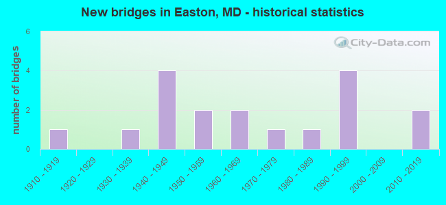
- New bridges - historical statistics
- 11910-1919
- 11930-1939
- 41940-1949
- 21950-1959
- 21960-1969
- 11970-1979
- 11980-1989
- 41990-1999
- 22010-2019

- Reconstructed bridges - Historical Statistics
- 31950-1959
- 11960-1969


- Bridge Condition - Deck
- 25.0%Very good
- 75.0%Satisfactory

- Bridge Condition - Superstructure
- 12.5%Very good
- 25.0%Good
- 62.5%Satisfactory

- Bridge Condition - Substructure
- 12.5%Very good
- 50.0%Good
- 25.0%Satisfactory
- 12.5%Fair

- Bridge Condition - Channel
- 5.6%Excellent
- 22.2%Very good
- 33.3%Good
- 27.8%Satisfactory
- 5.6%Fair
- 5.6%Poor

- Bridge Condition - Culverts
- 70.0%Satisfactory
- 30.0%Fair
Find on map >> Show street view
Structure Number: 10000020000602, Location: 1.26 MILES E OF MD 662B (Lat: 38.853744, Lng: -76.060900), Route carried "on" structure: US 50, Year Built: 1945, Year Reconstructed: 1961, Status: Open, Structure Length: 0.73m (2.40ft), Average Daily Traffic: 31,938 (year 2009), Truck Traffic: 8%, Average Future Daily Traffic: 36,955 (year 2026), Design Load: H 20, Features Intersected: TRIB TO POTTS MILL CREEK
Minimum Vertical Clearance: 30+ m (98+ ft), Kilometerpoint: 9.463, Lanes on structure: 4, Base Highway Network: Yes, Owner: State Highway Agency, Approaching Roadway Width: 29.3m (96.1ft), Skew: 4 degrees, Material/Design: Concrete, Design/Construction: Culvert, Number Of Spans In Main Unit: 2, Length of Maximum Span: 3.4m (11.2ft)
Condition: Channel: Satisfactory, Culverts: Satisfactory, Operating Rating: 59.0 metric tons, Method Used To Determine Operating Rating: Load Factor (LF), Inventory Rating: 35.4 metric tons, Method Used To Determine Inventory Rating: Load Factor (LF), Structural Evaluation: Equal to present minimum criteria, Waterway Adequacy: Equal to present desirable criteria, Approach Roadway Alignment: Equal to present desirable criteria, Designated Inspection Frequency: Every 24 months, Inspection Date: June 2020, Deck Structure Type: Concrete Cast-file-Place, Wearing Surface/Protective System: Wearing Surface: Monolithic Concrete
Find on map >> Show street view
Structure Number: 10000020000702, Location: 1.75 MILES WEST OF MD 309 (Lat: 38.838081, Lng: -76.060592), Route carried "on" structure: US 50, Year Built: 1945, Year Reconstructed: 1960, Status: Open, Structure Length: 3.57m (11.71ft), Average Daily Traffic: 31,938 (year 2009), Truck Traffic: 8%, Average Future Daily Traffic: 36,955 (year 2026), Design Load: HS 20, Features Intersected: BR OF POTTS MILL CREEK
Minimum Vertical Clearance: 30+ m (98+ ft), Kilometerpoint: 11.215, Lanes on structure: 4, Base Highway Network: Yes, Owner: State Highway Agency, Approaching Roadway Width: 29.9m (98.1ft), Skew: 2 degrees, Material/Design: Concrete, Design/Construction: Culvert, Length of Maximum Span: 3.0m (9.8ft)
Condition: Channel: Poor, Culverts: Satisfactory, Operating Rating: 32.7 metric tons, Method Used To Determine Operating Rating: Field evaluation and documented engineering judgment, Inventory Rating: 32.7 metric tons, Method Used To Determine Inventory Rating: Field evaluation and documented engineering judgment, Structural Evaluation: Equal to present minimum criteria, Waterway Adequacy: Equal to present desirable criteria, Approach Roadway Alignment: Equal to present desirable criteria, Designated Inspection Frequency: Every 24 months, Inspection Date: September 2021
Find on map >> Show street view
Structure Number: 10000020000802, Location: 0.89 MILE WEST OF MD 322 (Lat: 38.751919, Lng: -76.064833), Route carried "on" structure: US 50, Year Built: 1945, Year Reconstructed: 1961, Status: Open, Structure Length: 3.78m (12.40ft), Average Daily Traffic: 24,631 (year 2009), Truck Traffic: 8%, Average Future Daily Traffic: 30,649 (year 2026), Design Load: HS 20, Features Intersected: PAPERMILL POND
Minimum Vertical Clearance: 30+ m (98+ ft), Kilometerpoint: 20.790, Lanes on structure: 4, Base Highway Network: Yes, Owner: State Highway Agency, Approaching Roadway Width: 29.9m (98.1ft), Material/Design: Concrete, Design/Construction: Culvert, Length of Maximum Span: 3.0m (9.8ft)
Condition: Channel: Satisfactory, Culverts: Satisfactory, Operating Rating: 32.7 metric tons, Method Used To Determine Operating Rating: Field evaluation and documented engineering judgment, Inventory Rating: 32.7 metric tons, Method Used To Determine Inventory Rating: Field evaluation and documented engineering judgment, Structural Evaluation: Equal to present minimum criteria, Waterway Adequacy: Equal to present desirable criteria, Approach Roadway Alignment: Equal to present desirable criteria, Designated Inspection Frequency: Every 24 months, Inspection Date: September 2021
Find on map >> Show street view
Structure Number: 10000020000902, Location: 0.26 MILE WEST OF MD 565 (Lat: 38.731222, Lng: -76.068344), Route carried "on" structure: US 50, Year Built: 1941, Year Reconstructed: 1961, Status: Open, Structure Length: 3.35m (10.99ft), Average Daily Traffic: 31,091 (year 2009), Truck Traffic: 8%, Average Future Daily Traffic: 35,467 (year 2026), Design Load: HS 20, Features Intersected: PEACHBLOSSOM CREEK
Minimum Vertical Clearance: 30+ m (98+ ft), Kilometerpoint: 23.154, Lanes on structure: 4, Base Highway Network: Yes, Owner: State Highway Agency, Approaching Roadway Width: 29.9m (98.1ft), Skew: 2 degrees, Material/Design: Concrete, Design/Construction: Culvert, Length of Maximum Span: 4.6m (15.1ft)
Condition: Channel: Good, Culverts: Satisfactory, Operating Rating: 32.7 metric tons, Method Used To Determine Operating Rating: Field evaluation and documented engineering judgment, Inventory Rating: 32.7 metric tons, Method Used To Determine Inventory Rating: Field evaluation and documented engineering judgment, Structural Evaluation: Equal to present minimum criteria, Waterway Adequacy: Equal to present desirable criteria, Approach Roadway Alignment: Equal to present desirable criteria, Designated Inspection Frequency: Every 24 months, Inspection Date: September 2021
Find on map >> Show street view
Structure Number: 10000020001301, Location: 2.32 MILES EAST OF US 50 (Lat: 38.796633, Lng: -76.025100), Route carried "on" structure: State highway 328, Year Built: 1936, Status: Open, Structure Length: 1.16m (3.81ft), Average Daily Traffic: 10,230 (year 2009), Truck Traffic: 8%, Average Future Daily Traffic: 12,706 (year 2026), Design Load: H 20, Features Intersected: WOOTENAUX CREEK
Minimum Vertical Clearance: 30+ m (98+ ft), Kilometerpoint: 3.751, Lanes on structure: 2, Base Highway Network: Yes, Owner: State Highway Agency, Approaching Roadway Width: 12.2m (40.0ft), Material/Design: Steel, Design/Construction: Stringer/Multi-beam, Number Of Spans In Main Unit: 1, Length of Maximum Span: 11.3m (37.1ft), Curb-To-Curb Width: 9.1m (29.9ft), Out-to-Out Width: 9.8m (32.2ft)
Condition: Deck: Satisfactory, Superstructure: Satisfactory, Substructure: Satisfactory, Channel: Good, Operating Rating: 68.9 metric tons, Method Used To Determine Operating Rating: Load Factor (LF), Inventory Rating: 42.6 metric tons, Method Used To Determine Inventory Rating: Load Factor (LF), Structural Evaluation: Equal to present minimum criteria, Deck Geometry: High priority of corrective action, Waterway Adequacy: Superior to present desirable criteria, Approach Roadway Alignment: Equal to present desirable criteria, Length Of Structure Improvement: 1.16m (3.81ft), Designated Inspection Frequency: Every 24 months, Inspection Date: Febuary 2021, Bridge Improvement Cost: $73,000, Roadway Improvement Cost: $7,000, Total Project Cost: $80,000, Deck Structure Type: Concrete Cast-file-Place, Wearing Surface/Protective System: Wearing Surface: Bituminous
Find on map >> Show street view
Structure Number: 10000020001502, Location: 0.12 MILE SOUTH OF MD 322 (Lat: 38.759128, Lng: -76.079675), Route carried "on" structure: State highway 333, Year Built: 1955, Status: Open, Structure Length: 1.52m (4.99ft), Average Daily Traffic: 8,882 (year 2018), Truck Traffic: 8%, Average Future Daily Traffic: 8,905 (year 2038), Design Load: H 20, Features Intersected: TRED AVON RIVER
Minimum Vertical Clearance: 30+ m (98+ ft), Kilometerpoint: 14.960, Lanes on structure: 2, Base Highway Network: Yes, Owner: State Highway Agency, Approaching Roadway Width: 14.6m (47.9ft), Material/Design: Concrete, Design/Construction: Culvert, Length of Maximum Span: 3.0m (9.8ft)
Condition: Channel: Satisfactory, Culverts: Fair, Operating Rating: 81.6 metric tons, Method Used To Determine Operating Rating: Load Factor (LF), Inventory Rating: 49.0 metric tons, Method Used To Determine Inventory Rating: Load Factor (LF), Structural Evaluation: Somewhat better than minimum adequacy, Waterway Adequacy: Equal to present desirable criteria, Approach Roadway Alignment: Equal to present desirable criteria, Designated Inspection Frequency: Every 24 months, Inspection Date: March 2020, Deck Structure Type: Concrete Cast-file-Place
Find on map >> Show street view
Structure Number: 10000020001601, Location: 1.95 MILES S OF MD 322 (Lat: 38.733872, Lng: -76.087778), Route carried "on" structure: State highway 333, Year Built: 1997, Status: Open, Structure Length: 17.22m (56.50ft), Average Daily Traffic: 7,672 (year 2009), Truck Traffic: 7%, Average Future Daily Traffic: 9,192 (year 2026), Design Load: HS 25 or greater, Features Intersected: PEACHBLOSSOM CREEK
Minimum Vertical Clearance: 30+ m (98+ ft), Kilometerpoint: 12.003, Lanes on structure: 2, Base Highway Network: Yes, Owner: State Highway Agency, Approaching Roadway Width: 12.2m (40.0ft), Material/Design: Prestressed concrete continuous, Design/Construction: Stringer/Multi-beam, Number Of Spans In Main Unit: 6, Length of Maximum Span: 30.5m (100.1ft), Curb-To-Curb Width: 11.0m (36.1ft), Out-to-Out Width: 11.9m (39.0ft)
Condition: Deck: Satisfactory, Superstructure: Good, Substructure: Good, Channel: Very good, Operating Rating: 88.0 metric tons, Method Used To Determine Operating Rating: Load Factor (LF), Inventory Rating: 52.6 metric tons, Method Used To Determine Inventory Rating: Load Factor (LF), Structural Evaluation: Better than present minimum criteria, Deck Geometry: Meets minimum limits, Waterway Adequacy: Superior to present desirable criteria, Approach Roadway Alignment: Equal to present desirable criteria, Designated Inspection Frequency: Every 24 months, Underwater Inspection Frequency: Every 48 months, Inspection Date: October 2020, Underwater Inspection Date: Febuary 2020, Deck Structure Type: Concrete Cast-file-Place, Wearing Surface/Protective System: Wearing Surface: Integral Concrete, Deck Protection: Epoxy Coated Reinforcing
Find on map >> Show street view
Structure Number: 10000020001701, Location: 0.67 M N OF SPRING ROAD (Lat: 38.713253, Lng: -76.091875), Route carried "on" structure: State highway 333, Year Built: 1998, Status: Open, Structure Length: 12.34m (40.49ft), Average Daily Traffic: 7,672 (year 2009), Truck Traffic: 7%, Average Future Daily Traffic: 9,192 (year 2026), Design Load: HS 25 or greater, Features Intersected: TRIPPE CREEK
Minimum Vertical Clearance: 30+ m (98+ ft), Kilometerpoint: 9.606, Lanes on structure: 2, Base Highway Network: Yes, Owner: State Highway Agency, Approaching Roadway Width: 12.2m (40.0ft), Material/Design: Prestressed concrete continuous, Design/Construction: Stringer/Multi-beam, Number Of Spans In Main Unit: 4, Length of Maximum Span: 30.5m (100.1ft), Curb-To-Curb Width: 11.0m (36.1ft), Out-to-Out Width: 11.9m (39.0ft)
Condition: Deck: Satisfactory, Superstructure: Satisfactory, Substructure: Good, Channel: Very good, Operating Rating: 88.9 metric tons, Method Used To Determine Operating Rating: Load Factor (LF), Inventory Rating: 53.1 metric tons, Method Used To Determine Inventory Rating: Load Factor (LF), Structural Evaluation: Equal to present minimum criteria, Deck Geometry: Meets minimum limits, Waterway Adequacy: Superior to present desirable criteria, Approach Roadway Alignment: Equal to present desirable criteria, Designated Inspection Frequency: Every 24 months, Underwater Inspection Frequency: Every 48 months, Inspection Date: October 2020, Underwater Inspection Date: Febuary 2020, Deck Structure Type: Concrete Cast-file-Place, Wearing Surface/Protective System: Wearing Surface: Integral Concrete, Deck Protection: Epoxy Coated Reinforcing
Find on map >> Show street view
Structure Number: 10000020001801, Location: 0.98 MILE NORTH OF MD 33 (Lat: 38.793386, Lng: -76.124803), Route carried "on" structure: State highway 370, Year Built: 1984, Status: Open, Structure Length: 38.98m (127.89ft), Average Daily Traffic: 2,772 (year 2017), Truck Traffic: 8%, Average Future Daily Traffic: 3,383 (year 2037), Design Load: HS 20, Features Intersected: MILES RIVER
Minimum Vertical Clearance: 30+ m (98+ ft), Kilometerpoint: 1.577, Lanes on structure: 2, Owner: State Highway Agency, Approaching Roadway Width: 8.5m (27.9ft), Navigation Control: Yes ( Vertical Clearance: 6.1m (20.0ft), Horizontal Clearance: 12.2m (40.0ft)), Material/Design: Steel, Design/Construction: Movable - Bascule, Number Of Spans In Main Unit: 1, Number Of Approach Spans: 19, Length of Maximum Span: 22.3m (73.2ft), Curb-To-Curb Width: 8.5m (27.9ft), Out-to-Out Width: 9.5m (31.2ft)
Condition: Deck: Satisfactory, Superstructure: Satisfactory, Substructure: Satisfactory, Channel: Good, Operating Rating: 50.8 metric tons, Method Used To Determine Operating Rating: Load Factor (LF), Inventory Rating: 30.4 metric tons, Method Used To Determine Inventory Rating: Load Factor (LF), Structural Evaluation: Equal to present minimum criteria, Deck Geometry: Meets minimum limits, Waterway Adequacy: Superior to present desirable criteria, Approach Roadway Alignment: Equal to present desirable criteria, Designated Inspection Frequency: Every 24 months, Critical Feature Inspection Frequency: Every 24 months, Underwater Inspection Frequency: Every 48 months, Other Special Inspection Frequency: Every 24 months, Inspection Date: September 2020, Critical Feature Inspection Date: September 2020, Underwater Inspection Date: July 2019, Other Special Inspection Date: September 2020, Deck Structure Type: Concrete Cast-file-Place, Wearing Surface/Protective System: Wearing Surface: Monolithic Concrete, Deck Protection: Epoxy Coated Reinforcing
Find on map >> Show street view
Structure Number: 10000020002201, Location: 2.05 MILES SOUTH OF US 50 (Lat: 38.848567, Lng: -76.081256), Route carried "on" structure: State highway 662C, Year Built: 1911, Status: Open, Structure Length: 1.04m (3.41ft), Average Daily Traffic: 1,481 (year 2009), Truck Traffic: 8%, Average Future Daily Traffic: 1,800 (year 2026), Features Intersected: POTTS MILL CREEK
Minimum Vertical Clearance: 30+ m (98+ ft), Kilometerpoint: 6.516, Lanes on structure: 2, Owner: State Highway Agency, Approaching Roadway Width: 6.7m (22.0ft), Skew: 2 degrees, Material/Design: Concrete, Design/Construction: Slab, Number Of Spans In Main Unit: 2, Length of Maximum Span: 4.9m (16.1ft), Curb-To-Curb Width: 6.6m (21.7ft), Out-to-Out Width: 7.1m (23.3ft)
Condition: Deck: Satisfactory, Superstructure: Satisfactory, Substructure: Good, Channel: Good, Operating Rating: 65.3 metric tons, Method Used To Determine Operating Rating: Load Factor (LF), Inventory Rating: 39.0 metric tons, Method Used To Determine Inventory Rating: Load Factor (LF), Structural Evaluation: Equal to present minimum criteria, Deck Geometry: High priority of replacement, Waterway Adequacy: Equal to present minimum criteria, Approach Roadway Alignment: Equal to present desirable criteria, Length Of Structure Improvement: 1.04m (3.41ft), Designated Inspection Frequency: Every 24 months, Underwater Inspection Frequency: Every 48 months, Inspection Date: June 2021, Underwater Inspection Date: Febuary 2020, Bridge Improvement Cost: $48,000, Roadway Improvement Cost: $5,000, Total Project Cost: $53,000, Deck Structure Type: Concrete Cast-file-Place, Wearing Surface/Protective System: Wearing Surface: Bituminous
Find on map >> Show street view
Structure Number: 10000020002603, Location: AT MD 33 (Lat: 38.777756, Lng: -76.085517), Route carried "on" structure: State highway 322, Year Built: 1966, Status: Open, Structure Length: 1.16m (3.81ft), Average Daily Traffic: 18,380 (year 2009), Truck Traffic: 8%, Average Future Daily Traffic: 28,740 (year 2029), Design Load: HS 20, Features Intersected: TANYARD BRANCH
Minimum Vertical Clearance: 30+ m (98+ ft), Kilometerpoint: 4.795, Lanes on structure: 2, Base Highway Network: Yes, Owner: State Highway Agency, Approaching Roadway Width: 13.4m (44.0ft), Skew: 4 degrees, Material/Design: Steel, Design/Construction: Culvert, Length of Maximum Span: 2.1m (6.9ft)
Condition: Channel: Very good, Culverts: Satisfactory, Structural Evaluation: Equal to present minimum criteria, Waterway Adequacy: Equal to present desirable criteria, Approach Roadway Alignment: Equal to present desirable criteria, Designated Inspection Frequency: Every 24 months, Inspection Date: September 2021
Find on map >> Show street view
Structure Number: 10000020002703, Location: 1.04 MILE NORTH OF US 50 (Lat: 38.754114, Lng: -76.072997), Route carried "on" structure: State highway 322, Year Built: 1970, Status: Open, Structure Length: 0.98m (3.22ft), Average Daily Traffic: 15,310 (year 2009), Truck Traffic: 8%, Average Future Daily Traffic: 18,932 (year 2026), Design Load: HS 20, Features Intersected: PAPERMILL POND
Minimum Vertical Clearance: 30+ m (98+ ft), Kilometerpoint: 1.691, Lanes on structure: 2, Base Highway Network: Yes, Owner: State Highway Agency, Approaching Roadway Width: 13.4m (44.0ft), Skew: 1 degrees, Material/Design: Steel, Design/Construction: Culvert, Number Of Spans In Main Unit: 3, Length of Maximum Span: 2.4m (7.9ft)
Condition: Channel: Very good, Culverts: Satisfactory, Structural Evaluation: Equal to present minimum criteria, Waterway Adequacy: Superior to present desirable criteria, Approach Roadway Alignment: Equal to present desirable criteria, Designated Inspection Frequency: Every 24 months, Inspection Date: September 2021
Find on map >> Show street view
Structure Number: 10000020002803, Location: 0.50 MILE NORTH OF MD 322 (Lat: 38.753797, Lng: -76.071336), Route carried "on" structure: State highway 565A, Year Built: 1950, Status: Open, Structure Length: 1.13m (3.71ft), Average Daily Traffic: 2,000 (year 2009), Truck Traffic: 8%, Average Future Daily Traffic: 2,686 (year 2026), Features Intersected: PAPERMILL POND
Minimum Vertical Clearance: 30+ m (98+ ft), Kilometerpoint: 0.805, Lanes on structure: 2, Owner: State Highway Agency, Approaching Roadway Width: 10.4m (34.1ft), Material/Design: Concrete, Design/Construction: Culvert, Length of Maximum Span: 1.2m (3.9ft)
Condition: Channel: Satisfactory, Culverts: Satisfactory, Operating Rating: 32.7 metric tons, Method Used To Determine Operating Rating: Field evaluation and documented engineering judgment, Inventory Rating: 32.7 metric tons, Method Used To Determine Inventory Rating: Field evaluation and documented engineering judgment, Structural Evaluation: Equal to present minimum criteria, Waterway Adequacy: Equal to present desirable criteria, Approach Roadway Alignment: Equal to present desirable criteria, Designated Inspection Frequency: Every 24 months, Inspection Date: September 2021
Find on map >> Show street view
Structure Number: 10000020003401, Location: ON CAROLINE CO LINE (Lat: 38.754653, Lng: -75.993022), Route carried "on" structure: State highway 331, Year Built: 2018, Status: Open, Structure Length: 61.59m (202.07ft), Average Daily Traffic: 13,600 (year 2011), Truck Traffic: 7%, Average Future Daily Traffic: 20,200 (year 2031), Features Intersected: CHOPTANK RIVER
Minimum Vertical Clearance: 30+ m (98+ ft), Kilometerpoint: 0.000, Lanes on structure: 2, Base Highway Network: Yes, Owner: State Highway Agency, Approaching Roadway Width: 12.2m (40.0ft), Material/Design: Steel continuous, Design/Construction: Stringer/Multi-beam, Number Of Spans In Main Unit: 13, Length of Maximum Span: 70.1m (230.0ft), Curb or Sidewalk Widths: Left: 0.6m (2.0ft), Right: 0.6m (2.0ft), Curb-To-Curb Width: 12.2m (40.0ft), Out-to-Out Width: 13.4m (44.0ft)
Condition: Deck: Very good, Superstructure: Very good, Substructure: Very good, Channel: Excellent, Operating Rating: 42.1 metric tons, Method Used To Determine Operating Rating: Load and Resistance Factor Rating (LRFR) rating reported by rating factor(RF) method using HL-93 loadings, Inventory Rating: 34.0 metric tons, Method Used To Determine Inventory Rating: Load and Resistance Factor Rating (LRFR) rating reported by rating factor(RF) method using HL-93 loadings, Structural Evaluation: Equal to present desirable criteria, Deck Geometry: Somewhat better than minimum adequacy, Waterway Adequacy: Superior to present desirable criteria, Approach Roadway Alignment: Equal to present desirable criteria, Designated Inspection Frequency: Every 24 months, Inspection Date: June 2020, Deck Structure Type: Concrete Cast-file-Place, Wearing Surface/Protective System: Wearing Surface: Integral Concrete, Deck Protection: Epoxy Coated Reinforcing
Find on map >> Show street view
Structure Number: 200000D-002601, Location: 1.27 MI E OF BUCKTOWN RD (Lat: 38.781586, Lng: -76.001686), Route carried "on" structure: County highway 169, Year Built: 1994, Status: Open, Structure Length: 3.90m (12.80ft), Average Daily Traffic: 234 (year 2019), Truck Traffic: 10%, Average Future Daily Traffic: 351 (year 2039), Design Load: HS 20, Features Intersected: TRANSQUAKING RIVER, Facility Carried by Structure: DECOURSEY BRIDGE
Minimum Vertical Clearance: 30+ m (98+ ft), Kilometerpoint: 6.404, Lanes on structure: 2, Owner: County Highway Agency, Approaching Roadway Width: 6.1m (20.0ft), Material/Design: Wood or Timber, Design/Construction: Slab, Number Of Spans In Main Unit: 5, Length of Maximum Span: 7.6m (24.9ft), Curb-To-Curb Width: 7.9m (25.9ft), Out-to-Out Width: 8.5m (27.9ft)
Condition: Deck: Satisfactory, Superstructure: Satisfactory, Substructure: Fair, Channel: Good, Structural Evaluation: Somewhat better than minimum adequacy, Deck Geometry: Somewhat better than minimum adequacy, Waterway Adequacy: Better than present minimum criteria, Approach Roadway Alignment: Equal to present desirable criteria, Designated Inspection Frequency: Every 24 months, Underwater Inspection Frequency: Every 48 months, Inspection Date: November 2021, Underwater Inspection Date: November 2019, Deck Structure Type: Wood or Timber, Wearing Surface/Protective System: Wearing Surface: Bituminous, Deck Protection: Internally Sealed
Find on map >> Show street view
Structure Number: 200000T-000603, Location: 0.5 MI SE OF MD 328 (Lat: 38.789028, Lng: -76.009333), Route carried "on" structure: County highway 276, Year Built: 1960, Status: Open, Structure Length: 0.94m (3.08ft), Average Daily Traffic: 250 (year 2015), Truck Traffic: 5%, Average Future Daily Traffic: 300 (year 2035), Features Intersected: KINGS CREEK, Facility Carried by Structure: MULLETT BRANCH ROA
Minimum Vertical Clearance: 30+ m (98+ ft), Kilometerpoint: 1.158, Lanes on structure: 2, Owner: County Highway Agency, Approaching Roadway Width: 6.1m (20.0ft), Skew: 1 degrees, Material/Design: Aluminum, Iron, Design/Construction: Culvert, Number Of Spans In Main Unit: 3, Length of Maximum Span: 2.4m (7.9ft)
Condition: Channel: Satisfactory, Culverts: Fair, Operating Rating: 63.0 metric tons, Method Used To Determine Operating Rating: Load Factor (LF), Inventory Rating: 37.6 metric tons, Method Used To Determine Inventory Rating: Load Factor (LF), Structural Evaluation: Somewhat better than minimum adequacy, Waterway Adequacy: Equal to present minimum criteria, Approach Roadway Alignment: Equal to present minimum criteria, Designated Inspection Frequency: Every 24 months, Inspection Date: December 2021
Find on map >> Show street view
Structure Number: 200000T-000903, Location: 0.5 MILE WEST OF US 50 (Lat: 38.852256, Lng: -76.062519), Route carried "on" structure: County highway 26, Year Built: 1991, Status: Open, Structure Length: 1.19m (3.90ft), Average Daily Traffic: 250 (year 2015), Truck Traffic: 5%, Average Future Daily Traffic: 300 (year 2035), Features Intersected: POTTS MILL CREEK, Facility Carried by Structure: RABBIT HILL ROAD
Minimum Vertical Clearance: 30+ m (98+ ft), Kilometerpoint: 0.000, Lanes on structure: 2, Owner: County Highway Agency, Approaching Roadway Width: 6.1m (20.0ft), Material/Design: Steel, Design/Construction: Culvert, Number Of Spans In Main Unit: 3, Length of Maximum Span: 3.7m (12.1ft)
Condition: Channel: Fair, Culverts: Fair, Structural Evaluation: Somewhat better than minimum adequacy, Waterway Adequacy: Somewhat better than minimum adequacy, Approach Roadway Alignment: Equal to present minimum criteria, Designated Inspection Frequency: Every 24 months, Inspection Date: December 2021
Find on map >> Show street view
Structure Number: 200000T-001104, Location: 850 FEET EAST OF US 50 (Lat: 38.758564, Lng: -76.059689), Route carried "on" structure: County highway 95, Year Built: 2010, Status: Open, Structure Length: 0.91m (2.99ft), Average Daily Traffic: 7,700 (year 2015), Truck Traffic: 5%, Average Future Daily Traffic: 9,350 (year 2035), Features Intersected: WINDMILL BRANCH, Facility Carried by Structure: DUTCHMAN'S LANE
Minimum Vertical Clearance: 30+ m (98+ ft), Kilometerpoint: 0.000, Lanes on structure: 2, Owner: County Highway Agency, Approaching Roadway Width: 11.6m (38.1ft), Material/Design: Concrete, Design/Construction: Frame, Number Of Spans In Main Unit: 1, Length of Maximum Span: 9.1m (29.9ft), Curb or Sidewalk Widths: Left: 0.0m, Right: 2.7m (8.9ft), Curb-To-Curb Width: 11.3m (37.1ft), Out-to-Out Width: 14.6m (47.9ft)
Condition: Deck: Very good, Superstructure: Good, Substructure: Good, Channel: Good, Operating Rating: 59.9 metric tons, Method Used To Determine Operating Rating: Load Factor (LF), Inventory Rating: 35.8 metric tons, Method Used To Determine Inventory Rating: Load Factor (LF), Structural Evaluation: Better than present minimum criteria, Deck Geometry: Meets minimum limits, Waterway Adequacy: Better than present minimum criteria, Approach Roadway Alignment: Equal to present desirable criteria, Designated Inspection Frequency: Every 24 months, Inspection Date: December 2021, Deck Structure Type: Concrete Cast-file-Place, Wearing Surface/Protective System: Wearing Surface: Bituminous, Deck Protection: Epoxy Coated Reinforcing