Bridge Statistics for East Rutherford, New Jersey (NJ)
Condition, Traffic, Stress, Structural Evaluation, Project Costs
- National Bridge Inventory (NBI) Statistics
- 45Number of bridges
- 951ft / 290mTotal length
- $41,032,000Total costs
- 1,893,804Total average daily traffic
- 161,023Total average daily truck traffic
- National Bridge Inventory (NBI) Registered Bridges for East Rutherford
- No street view available for this location
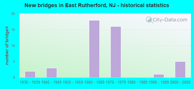
- New bridges - historical statistics
- 21930-1939
- 31940-1949
- 181960-1969
- 161970-1979
- 11990-1999
- 52000-2009

- Reconstructed bridges - Historical Statistics
- 11950-1959
- 21960-1969
- 21970-1979
- 01980-1989
- 11990-1999
- 52000-2009
- 12010-2019


- Bridge Condition - Deck
- 8.3%Very good
- 41.7%Good
- 41.7%Satisfactory
- 8.3%Poor

- Bridge Condition - Superstructure
- 16.7%Very good
- 29.2%Good
- 33.3%Satisfactory
- 16.7%Fair
- 4.2%Poor

- Bridge Condition - Substructure
- 4.2%Very good
- 37.5%Good
- 41.7%Satisfactory
- 16.7%Fair

- Bridge Condition - Channel
- 40.0%Very good
- 60.0%Good
Find on map >> Show street view
Structure Number: 20012A, Location: 0.01 MI N OF ERIE AVE. (Lat: 40.838381, Lng: -74.105731), Route carried "on" structure: City street , Year Built: 1993, Status: Open, Structure Length: 2.77m (9.09ft), Average Daily Traffic: 3,621 (year 2020), Truck Traffic: 1%, Average Future Daily Traffic: 4,346 (year 2040), Design Load: HS 20+Mod, Features Intersected: ERIE-LACKAWANNA RR, Facility Carried by Structure: MAPLE STREET
Minimum Vertical Clearance: 30+ m (98+ ft), Kilometerpoint: 0.016, Lanes on structure: 2, Owner: County Highway Agency, Approaching Roadway Width: 9.1m (29.9ft), Skew: 1 degrees, Material/Design: Prestressed concrete, Design/Construction: Box Beam or Girders - Multiple, Number Of Spans In Main Unit: 2, Length of Maximum Span: 16.8m (55.1ft), Curb or Sidewalk Widths: Left: 1.8m (5.9ft), Right: 1.8m (5.9ft), Curb-To-Curb Width: 9.1m (29.9ft), Out-to-Out Width: 13.4m (44.0ft)
Condition: Deck: Good, Superstructure: Very good, Substructure: Good, Operating Rating: 85.3 metric tons, Method Used To Determine Operating Rating: Load Factor (LF), Inventory Rating: 50.8 metric tons, Method Used To Determine Inventory Rating: Load Factor (LF), Structural Evaluation: Better than present minimum criteria, Deck Geometry: Meets minimum limits, Approach Roadway Alignment: Equal to present minimum criteria, Designated Inspection Frequency: Every 24 months, Inspection Date: April 2020, Deck Structure Type: Concrete Cast-file-Place, Wearing Surface/Protective System: Wearing Surface: Monolithic Concrete, Deck Protection: Epoxy Coated Reinforcing
Find on map >> Show street view
Structure Number: 20415, Location: 1.25 MI.WEST W.SPUR NJTPK (Lat: 40.810539, Lng: -74.093719), Route carried "on" structure: State highway 3, Year Built: 1945, Year Reconstructed: 1996, Status: Open, Structure Length: 31.21m (102.40ft), Average Daily Traffic: 130,590 (year 2020), Truck Traffic: 5%, Average Future Daily Traffic: 159,350 (year 2040), Design Load: HS 25 or greater, Features Intersected: SERVICE RD,BERRY'S CK,RR
Minimum Vertical Clearance: 30+ m (98+ ft), Kilometerpoint: 11.137, Lanes on structure: 8, Lanes under structure: 4, Base Highway Network: Yes, Owner: State Highway Agency, Approaching Roadway Width: 42.7m (140.1ft), Skew: 31 degrees, Material/Design: Steel continuous, Design/Construction: Stringer/Multi-beam, Number Of Spans In Main Unit: 13, Length of Maximum Span: 36.6m (120.1ft), Curb-To-Curb Width: 40.7m (133.5ft), Out-to-Out Width: 42.5m (139.4ft)
Condition: Deck: Good, Superstructure: Good, Substructure: Satisfactory, Channel: Good, Operating Rating: 59.9 metric tons, Method Used To Determine Operating Rating: Load Factor (LF), Inventory Rating: 35.4 metric tons, Method Used To Determine Inventory Rating: Load Factor (LF), Structural Evaluation: Equal to present minimum criteria, Deck Geometry: Superior to present desirable criteria, Underclear: Equal to present minimum criteria, Waterway Adequacy: Superior to present desirable criteria, Approach Roadway Alignment: Equal to present desirable criteria, Designated Inspection Frequency: Every 24 months, Underwater Inspection Frequency: Every 48 months, Inspection Date: July 2020, Underwater Inspection Date: September 2020, Deck Structure Type: Concrete Cast-file-Place, Wearing Surface/Protective System: Wearing Surface: Monolithic Concrete, Deck Protection: Epoxy Coated Reinforcing
Find on map >> Show street view
Structure Number: 204151, Location: 0.4 MI E NJTPK EXIT 16W (Lat: 40.798431, Lng: -74.064019), Route carried "on" structure: State highway 3, Year Built: 1963, Year Reconstructed: 2011, Status: Open, Structure Length: 80.04m (262.60ft), Average Daily Traffic: 77,006 (year 2021), Truck Traffic: 5%, Average Future Daily Traffic: 93,961 (year 2041), Design Load: HS 20+Mod, Features Intersected: HCKNSCK R, MEADWLND PKWY
Minimum Vertical Clearance: 30+ m (98+ ft), Kilometerpoint: 13.679, Lanes on structure: 4, Lanes under structure: 4, Base Highway Network: Yes, Owner: State Highway Agency, Approaching Roadway Width: 17.1m (56.1ft), Navigation Control: Yes ( Vertical Clearance: 15.2m (49.9ft), Horizontal Clearance: 45.7m (149.9ft)), Material/Design: Steel, Design/Construction: Stringer/Multi-beam, Number Of Spans In Main Unit: 25, Length of Maximum Span: 57.9m (190.0ft), Curb-To-Curb Width: 17.0m (55.8ft), Out-to-Out Width: 18.1m (59.4ft)
Condition: Deck: Good, Superstructure: Fair, Substructure: Good, Channel: Good, Operating Rating: 76.2 metric tons, Method Used To Determine Operating Rating: Load Factor (LF), Inventory Rating: 45.4 metric tons, Method Used To Determine Inventory Rating: Load Factor (LF), Structural Evaluation: Somewhat better than minimum adequacy, Deck Geometry: Meets minimum limits, Underclear: Equal to present minimum criteria, Waterway Adequacy: Superior to present desirable criteria, Approach Roadway Alignment: Equal to present desirable criteria, Designated Inspection Frequency: Every 24 months, Underwater Inspection Frequency: Every 48 months, Inspection Date: March 2021, Underwater Inspection Date: May 2021, Deck Structure Type: Concrete Cast-file-Place, Wearing Surface/Protective System: Wearing Surface: Monolithic Concrete, Deck Protection: Epoxy Coated Reinforcing
Find on map >> Show street view
Structure Number: 204152, Location: 0.25 MI E OF NJ TURNPIKE (Lat: 40.797300, Lng: -74.066261), Route carried "on" structure: State highway 3, Year Built: 1934, Year Reconstructed: 1964, Status: Open, Structure Length: 47.46m (155.71ft), Average Daily Traffic: 54,317 (year 2021), Truck Traffic: 5%, Average Future Daily Traffic: 66,277 (year 2041), Design Load: HS 20, Features Intersected: HCKNSCK R & MEADWLND PKW
Minimum Vertical Clearance: 5.21m (17.09ft), Kilometerpoint: 13.663, Lanes on structure: 4, Lanes under structure: 4, Base Highway Network: Yes, Owner: State Highway Agency, Approaching Roadway Width: 16.2m (53.1ft), Navigation Control: Yes ( Vertical Clearance: 15.2m (49.9ft), Horizontal Clearance: 45.7m (149.9ft)), Material/Design: Steel, Design/Construction: Truss - Thru, Number Of Spans In Main Unit: 1, Number Of Approach Spans: 15, Length of Maximum Span: 56.4m (185.0ft), Curb or Sidewalk Widths: Left: 0.6m (2.0ft), Right: 0.6m (2.0ft), Curb-To-Curb Width: 16.2m (53.1ft), Out-to-Out Width: 18.3m (60.0ft)
Condition: Deck: Poor, Superstructure: Poor, Substructure: Satisfactory, Channel: Very good, Operating Rating: 46.3 metric tons, Method Used To Determine Operating Rating: Load Factor (LF), Inventory Rating: 28.1 metric tons, Method Used To Determine Inventory Rating: Load Factor (LF), Structural Evaluation: Meets minimum limits, Deck Geometry: Meets minimum limits, Underclear: High priority of corrective action, Waterway Adequacy: Superior to present desirable criteria, Approach Roadway Alignment: Equal to present desirable criteria, Length Of Structure Improvement: 47.46m (155.71ft), Designated Inspection Frequency: Every 24 months, Critical Feature Inspection Frequency: Every 24 months, Underwater Inspection Frequency: Every 48 months, Other Special Inspection Frequency: Every 12 months, Inspection Date: March 2021, Critical Feature Inspection Date: March 2021, Underwater Inspection Date: May 2021, Other Special Inspection Date: March 2021, Bridge Improvement Cost: $18,713,000, Total Project Cost: $27,682,000 ( Estimate for 2021), Deck Structure Type: Concrete Cast-file-Place, Wearing Surface/Protective System: Wearing Surface: Bituminous
Find on map >> Show street view
Structure Number: 212153, Location: 1.6 MI NORTH OF NJ 3 (Lat: 40.832950, Lng: -74.088861), Route carried "on" structure: State highway 120, Year Built: 1969, Year Reconstructed: 2010, Status: Open, Structure Length: 4.45m (14.60ft), Average Daily Traffic: 21,100 (year 2021), Truck Traffic: 4%, Average Future Daily Traffic: 25,300 (year 2041), Design Load: HL 93, Features Intersected: NJ 17
Minimum Vertical Clearance: 30+ m (98+ ft), Kilometerpoint: 4.265, Lanes on structure: 5, Lanes under structure: 8, Base Highway Network: Yes, Owner: State Highway Agency, Approaching Roadway Width: 20.7m (67.9ft), Skew: 1 degrees, Material/Design: Steel, Design/Construction: Stringer/Multi-beam, Number Of Spans In Main Unit: 2, Length of Maximum Span: 21.9m (71.9ft), Curb or Sidewalk Widths: Left: 1.8m (5.9ft), Right: 1.8m (5.9ft), Curb-To-Curb Width: 21.1m (69.2ft), Out-to-Out Width: 25.4m (83.3ft)
Condition: Deck: Good, Superstructure: Very good, Substructure: Good, Operating Rating: 62.5 metric tons, Method Used To Determine Operating Rating: Load and Resistance Factor Rating (LRFR) rating reported by rating factor(RF) method using HL-93 loadings, Inventory Rating: 51.5 metric tons, Method Used To Determine Inventory Rating: Load and Resistance Factor Rating (LRFR) rating reported by rating factor(RF) method using HL-93 loadings, Structural Evaluation: Better than present minimum criteria, Deck Geometry: Somewhat better than minimum adequacy, Underclear: Equal to present minimum criteria, Approach Roadway Alignment: Equal to present minimum criteria, Designated Inspection Frequency: Every 24 months, Inspection Date: September 2021, Deck Structure Type: Concrete Cast-file-Place, Wearing Surface/Protective System: Deck Protection: Epoxy Coated Reinforcing
Find on map >> Show street view
Structure Number: 212154, Location: 0.05 MI WEST OF NJ 17 (Lat: 40.832489, Lng: -74.086931), Route carried "on" structure: State highway 120, Year Built: 1969, Year Reconstructed: 2011, Status: Open, Structure Length: 6.80m (22.31ft), Average Daily Traffic: 10,830 (year 2021), Truck Traffic: 6%, Average Future Daily Traffic: 12,995 (year 2041), Design Load: HL 93, Features Intersected: NJ TRANSIT AND 13TH ST
Minimum Vertical Clearance: 30+ m (98+ ft), Kilometerpoint: 4.136, Lanes on structure: 6, Lanes under structure: 2, Base Highway Network: Yes, Owner: State Highway Agency, Approaching Roadway Width: 25.6m (84.0ft), Skew: 31 degrees, Material/Design: Steel, Design/Construction: Stringer/Multi-beam, Number Of Spans In Main Unit: 3, Length of Maximum Span: 25.3m (83.0ft), Curb or Sidewalk Widths: Left: 1.8m (5.9ft), Right: 1.8m (5.9ft), Curb-To-Curb Width: 25.6m (84.0ft), Out-to-Out Width: 30.5m (100.1ft)
Condition: Deck: Very good, Superstructure: Good, Substructure: Good, Operating Rating: 65.4 metric tons, Method Used To Determine Operating Rating: Load and Resistance Factor Rating (LRFR) rating reported by rating factor(RF) method using HL-93 loadings, Inventory Rating: 59.6 metric tons, Method Used To Determine Inventory Rating: Load and Resistance Factor Rating (LRFR) rating reported by rating factor(RF) method using HL-93 loadings, Structural Evaluation: Better than present minimum criteria, Deck Geometry: Somewhat better than minimum adequacy, Underclear: High priority of corrective action, Approach Roadway Alignment: Equal to present desirable criteria, Designated Inspection Frequency: Every 24 months, Inspection Date: September 2021, Deck Structure Type: Concrete Cast-file-Place, Wearing Surface/Protective System: Wearing Surface: Monolithic Concrete
Find on map >> Show street view
Structure Number: 21915, Location: AT 120-3 JCT. (Lat: 40.803231, Lng: -74.073331), Route carried "on" structure: Ramp State highway 3, Year Built: 1964, Year Reconstructed: 1970, Status: Open, Structure Length: 4.82m (15.81ft), Average Daily Traffic: 8,300 (year 2020), Truck Traffic: 5%, Average Future Daily Traffic: 10,130 (year 2040), Design Load: HS 20+Mod, Features Intersected: NJ 3 EB & NJ 120 SB, Facility Carried by Structure: RAMP TO NJ 120 NB
Minimum Vertical Clearance: 30.18m (99.02ft), Kilometerpoint: 13.003, Lanes on structure: 2, Lanes under structure: 6, Owner: State Highway Agency, Approaching Roadway Width: 9.1m (29.9ft), Material/Design: Steel, Design/Construction: Stringer/Multi-beam, Number Of Spans In Main Unit: 3, Length of Maximum Span: 29.0m (95.1ft), Curb or Sidewalk Widths: Left: 0.5m (1.6ft), Right: 0.5m (1.6ft), Curb-To-Curb Width: 9.1m (29.9ft), Out-to-Out Width: 10.9m (35.8ft)
Condition: Deck: Poor, Superstructure: Satisfactory, Substructure: Satisfactory, Operating Rating: 62.6 metric tons, Method Used To Determine Operating Rating: Load Factor (LF), Inventory Rating: 38.1 metric tons, Method Used To Determine Inventory Rating: Load Factor (LF), Structural Evaluation: Equal to present minimum criteria, Deck Geometry: Meets minimum limits, Underclear: High priority of replacement, Approach Roadway Alignment: Somewhat better than minimum adequacy, Length Of Structure Improvement: 5.85m (19.19ft), Designated Inspection Frequency: Every 24 months, Inspection Date: April 2020, Bridge Improvement Cost: $2,406,000, Roadway Improvement Cost: $361,000, Total Project Cost: $4,068,000 ( Estimate for 2018), Deck Structure Type: Concrete Cast-file-Place, Wearing Surface/Protective System: Wearing Surface: Bituminous
Find on map >> Show street view
Structure Number: 219151, Location: 0.5 MI WEST HACKENSACK R. (Lat: 40.805439, Lng: -74.073831), Route carried "on" structure: State highway 120, Year Built: 1964, Status: Open, Structure Length: 4.63m (15.19ft), Average Daily Traffic: 19,000 (year 2020), Truck Traffic: 5%, Average Future Daily Traffic: 23,180 (year 2040), Design Load: HS 20+Mod, Features Intersected: NJ 3 WB
Minimum Vertical Clearance: 30+ m (98+ ft), Kilometerpoint: 0.000, Lanes on structure: 4, Lanes under structure: 4, Base Highway Network: Yes, Owner: State Highway Agency, Approaching Roadway Width: 20.7m (67.9ft), Skew: 33 degrees, Material/Design: Steel, Design/Construction: Stringer/Multi-beam, Number Of Spans In Main Unit: 3, Length of Maximum Span: 23.2m (76.1ft), Curb-To-Curb Width: 20.4m (66.9ft), Out-to-Out Width: 21.9m (71.9ft)
Condition: Deck: Very good, Superstructure: Satisfactory, Substructure: Satisfactory, Inventory Rating: 63.5 metric tons, Method Used To Determine Inventory Rating: Load Factor (LF), Structural Evaluation: Equal to present minimum criteria, Deck Geometry: Equal to present minimum criteria, Underclear: High priority of replacement, Approach Roadway Alignment: Equal to present minimum criteria, Length Of Structure Improvement: 5.61m (18.41ft), Designated Inspection Frequency: Every 24 months, Inspection Date: April 2020, Bridge Improvement Cost: $4,792,000, Roadway Improvement Cost: $720,000, Total Project Cost: $8,102,000 ( Estimate for 2018), Deck Structure Type: Concrete Cast-file-Place, Wearing Surface/Protective System: Deck Protection: Epoxy Coated Reinforcing
Find on map >> Show street view
Structure Number: 219152, Location: 1.0 MI NORTH OF RT 3 (Lat: 40.816911, Lng: -74.066500), Route carried "on" structure: State highway 120, Year Built: 1975, Status: Open, Structure Length: 5.00m (16.40ft), Average Daily Traffic: 26,400 (year 2020), Truck Traffic: 5%, Average Future Daily Traffic: 31,700 (year 2040), Design Load: HS 20+Mod, Features Intersected: CR 503 (WASHINGTON AVE)
Minimum Vertical Clearance: 30+ m (98+ ft), Kilometerpoint: 1.674, Lanes on structure: 3, Lanes under structure: 4, Base Highway Network: Yes, Owner: State Highway Agency, Approaching Roadway Width: 16.8m (55.1ft), Skew: 33 degrees, Material/Design: Steel, Design/Construction: Stringer/Multi-beam, Number Of Spans In Main Unit: 2, Length of Maximum Span: 23.8m (78.1ft), Curb or Sidewalk Widths: Left: 0.8m (2.6ft), Right: 1.8m (5.9ft), Curb-To-Curb Width: 15.8m (51.8ft), Out-to-Out Width: 20.0m (65.6ft)
Condition: Deck: Satisfactory, Superstructure: Good, Substructure: Fair, Inventory Rating: 60.8 metric tons, Method Used To Determine Inventory Rating: Load Factor (LF), Structural Evaluation: Somewhat better than minimum adequacy, Deck Geometry: Somewhat better than minimum adequacy, Underclear: Somewhat better than minimum adequacy, Approach Roadway Alignment: Better than present minimum criteria, Designated Inspection Frequency: Every 24 months, Inspection Date: August 2020, Deck Structure Type: Concrete Cast-file-Place
Find on map >> Show street view
Structure Number: 23815, Location: .6 MI SOUTH OF RT 17 JCT (Lat: 40.828031, Lng: -74.079419), Route carried "on" structure: State highway 120, Year Built: 1976, Status: Open, Structure Length: 5.43m (17.81ft), Average Daily Traffic: 24,600 (year 2020), Truck Traffic: 4%, Average Future Daily Traffic: 29,500 (year 2040), Design Load: HS 20, Features Intersected: BERRYS CREEK
Minimum Vertical Clearance: 30+ m (98+ ft), Kilometerpoint: 3.331, Lanes on structure: 4, Base Highway Network: Yes, Owner: State Highway Agency, Approaching Roadway Width: 15.8m (51.8ft), Skew: 30 degrees, Navigation Control: Yes ( Vertical Clearance: 1.8m (5.9ft), Horizontal Clearance: 18.3m (60.0ft)), Material/Design: Steel continuous, Design/Construction: Stringer/Multi-beam, Number Of Spans In Main Unit: 3, Length of Maximum Span: 20.4m (66.9ft), Curb or Sidewalk Widths: Left: 1.8m (5.9ft), Right: 1.8m (5.9ft), Curb-To-Curb Width: 16.5m (54.1ft), Out-to-Out Width: 21.3m (69.9ft)
Condition: Deck: Satisfactory, Superstructure: Good, Substructure: Satisfactory, Channel: Good, Operating Rating: 87.1 metric tons, Method Used To Determine Operating Rating: Load Factor (LF), Inventory Rating: 52.6 metric tons, Method Used To Determine Inventory Rating: Load Factor (LF), Structural Evaluation: Equal to present minimum criteria, Deck Geometry: Meets minimum limits, Waterway Adequacy: Equal to present desirable criteria, Approach Roadway Alignment: Better than present minimum criteria, Designated Inspection Frequency: Every 24 months, Underwater Inspection Frequency: Every 48 months, Inspection Date: August 2020, Underwater Inspection Date: August 2020, Deck Structure Type: Concrete Cast-file-Place, Wearing Surface/Protective System: Wearing Surface: Bituminous
Find on map >> Show street view
Structure Number: 4900001, Location: BETW METLIFE STDM & ARENA (Lat: 40.807961, Lng: -74.072281), Route carried "on" structure: Ramp Other road , Year Built: 1975, Status: Open, Structure Length: 6.04m (19.82ft), Average Daily Traffic: 3,725 (year 2020), Truck Traffic: 1%, Average Future Daily Traffic: 4,545 (year 2040), Design Load: HS 20, Features Intersected: NJ 120, Facility Carried by Structure: SO CONN RD, RAMP R
Minimum Vertical Clearance: 30+ m (98+ ft), Kilometerpoint: 0.000, Lanes on structure: 4, Lanes under structure: 9, Owner: State Agenciy, Approaching Roadway Width: 16.2m (53.1ft), Skew: 29 degrees, Material/Design: Steel, Design/Construction: Stringer/Multi-beam, Number Of Spans In Main Unit: 2, Length of Maximum Span: 29.9m (98.1ft), Curb or Sidewalk Widths: Left: 0.8m (2.6ft), Right: 0.8m (2.6ft), Curb-To-Curb Width: 16.2m (53.1ft), Out-to-Out Width: 19.7m (64.6ft)
Condition: Deck: Satisfactory, Superstructure: Satisfactory, Substructure: Satisfactory, Inventory Rating: 64.4 metric tons, Method Used To Determine Inventory Rating: Load Factor (LF), Structural Evaluation: Equal to present minimum criteria, Deck Geometry: Meets minimum limits, Underclear: High priority of corrective action, Approach Roadway Alignment: Equal to present minimum criteria, Length Of Structure Improvement: 1.98m (6.50ft), Designated Inspection Frequency: Every 24 months, Inspection Date: June 2020, Bridge Improvement Cost: $50,000, Total Project Cost: $50,000 ( Estimate for 2020), Deck Structure Type: Concrete Cast-file-Place, Wearing Surface/Protective System: Wearing Surface: Monolithic Concrete
Find on map >> Show street view
Structure Number: 4900002, Location: BETW GIANTS STDM & ARENA (Lat: 40.814139, Lng: -74.068881), Route carried "on" structure: Ramp Other road , Year Built: 1975, Status: Open, Structure Length: 5.67m (18.60ft), Average Daily Traffic: 3,950 (year 2020), Truck Traffic: 1%, Average Future Daily Traffic: 4,820 (year 2040), Design Load: HS 20, Features Intersected: NJ 120, Facility Carried by Structure: NO CONN RD, RAMP F
Minimum Vertical Clearance: 30+ m (98+ ft), Kilometerpoint: 0.000, Lanes on structure: 6, Lanes under structure: 8, Owner: State Agenciy, Approaching Roadway Width: 26.8m (87.9ft), Skew: 30 degrees, Material/Design: Steel, Design/Construction: Stringer/Multi-beam, Number Of Spans In Main Unit: 2, Length of Maximum Span: 28.3m (92.8ft), Curb or Sidewalk Widths: Left: 0.8m (2.6ft), Right: 0.8m (2.6ft), Curb-To-Curb Width: 26.8m (87.9ft), Out-to-Out Width: 30.3m (99.4ft)
Condition: Deck: Satisfactory, Superstructure: Satisfactory, Substructure: Satisfactory, Inventory Rating: 64.4 metric tons, Method Used To Determine Inventory Rating: Load Factor (LF), Structural Evaluation: Equal to present minimum criteria, Deck Geometry: Superior to present desirable criteria, Underclear: High priority of corrective action, Approach Roadway Alignment: Equal to present minimum criteria, Length Of Structure Improvement: 5.70m (18.70ft), Designated Inspection Frequency: Every 24 months, Inspection Date: June 2020, Roadway Improvement Cost: $100,000, Total Project Cost: $100,000 ( Estimate for 2020), Deck Structure Type: Concrete Cast-file-Place, Wearing Surface/Protective System: Wearing Surface: Monolithic Concrete
Find on map >> Show street view
Structure Number: W11272B, Location: INTERCHANGE 16 W (Lat: 40.799011, Lng: -74.076144), Route carried "on" structure: Ramp Interstate 95, Year Built: 1971, Year Reconstructed: 1976, Status: Open, Structure Length: 14.08m (46.19ft), Average Daily Traffic: 26,190 (year 2021), Truck Traffic: 14%, Average Future Daily Traffic: 31,950 (year 2041), Design Load: HS 20, Features Intersected: BERRYS CREEK CANAL, Facility Carried by Structure: NJ TPK INT.16W ST
Minimum Vertical Clearance: 30+ m (98+ ft), Kilometerpoint: 11.121, Lanes on structure: 2, Toll: On toll road, Owner: State Toll Authority, Approaching Roadway Width: 7.3m (24.0ft), Navigation Control: Yes ( Vertical Clearance: 11.0m (36.1ft), Horizontal Clearance: 48.8m (160.1ft)), Material/Design: Steel, Design/Construction: Stringer/Multi-beam, Number Of Spans In Main Unit: 3, Length of Maximum Span: 52.4m (171.9ft), Curb or Sidewalk Widths: Left: 0.6m (2.0ft), Right: 0.6m (2.0ft), Curb-To-Curb Width: 7.3m (24.0ft), Out-to-Out Width: 9.1m (29.9ft)
Condition: Deck: Satisfactory, Superstructure: Fair, Substructure: Satisfactory, Channel: Very good, Operating Rating: 55.1 metric tons, Method Used To Determine Operating Rating: Load and Resistance Factor Rating (LRFR) rating reported by rating factor(RF) method using HL-93 loadings, Inventory Rating: 42.4 metric tons, Method Used To Determine Inventory Rating: Load and Resistance Factor Rating (LRFR) rating reported by rating factor(RF) method using HL-93 loadings, Structural Evaluation: Somewhat better than minimum adequacy, Deck Geometry: High priority of replacement, Waterway Adequacy: Superior to present desirable criteria, Approach Roadway Alignment: Equal to present desirable criteria, Length Of Structure Improvement: 14.08m (46.19ft), Designated Inspection Frequency: Every 24 months, Underwater Inspection Frequency: Every 48 months, Inspection Date: April 2021, Underwater Inspection Date: April 2021, Bridge Improvement Cost: $450,000, Roadway Improvement Cost: $50,000, Total Project Cost: $500,000 ( Estimate for 2017), Deck Structure Type: Concrete Cast-file-Place, Wearing Surface/Protective System: Wearing Surface: Bituminous, Membrane: Other
Find on map >> Show street view
Structure Number: W11272D, Location: INTERCHANGE 16W (Lat: 40.808333, Lng: -74.081667), Route carried "on" structure: Ramp Interstate 95, Year Built: 1969, Year Reconstructed: 2009, Status: Open, Structure Length: 6.00m (19.69ft), Average Daily Traffic: 56,847 (year 2021), Truck Traffic: 16%, Average Future Daily Traffic: 69,364 (year 2041), Design Load: HS 20, Features Intersected: NJ ROUTE 3, Facility Carried by Structure: NJ Turnpike
Minimum Vertical Clearance: 30+ m (98+ ft), Kilometerpoint: 11.668, Lanes on structure: 5, Lanes under structure: 8, Toll: On toll road, Owner: State Toll Authority, Approaching Roadway Width: 27.4m (89.9ft), Skew: 20 degrees, Material/Design: Steel, Design/Construction: Stringer/Multi-beam, Number Of Spans In Main Unit: 3, Length of Maximum Span: 39.9m (130.9ft), Curb-To-Curb Width: 27.4m (89.9ft), Out-to-Out Width: 29.9m (98.1ft)
Condition: Deck: Good, Superstructure: Satisfactory, Substructure: Good, Operating Rating: 66.7 metric tons, Method Used To Determine Operating Rating: Load and Resistance Factor Rating (LRFR) rating reported by rating factor(RF) method using HL-93 loadings, Inventory Rating: 51.5 metric tons, Method Used To Determine Inventory Rating: Load and Resistance Factor Rating (LRFR) rating reported by rating factor(RF) method using HL-93 loadings, Structural Evaluation: Equal to present minimum criteria, Deck Geometry: Superior to present desirable criteria, Underclear: High priority of corrective action, Approach Roadway Alignment: Equal to present desirable criteria, Length Of Structure Improvement: 6.00m (19.69ft), Designated Inspection Frequency: Every 24 months, Inspection Date: March 2021, Deck Structure Type: Concrete Cast-file-Place, Wearing Surface/Protective System: Wearing Surface: Latex Concrete, Membrane: Other
Find on map >> Show street view
Structure Number: W11272L, Location: INTERCHANGE 16W (Lat: 40.808217, Lng: -74.079272), Route carried "on" structure: Ramp Interstate 95, Year Built: 2009, Status: Open, Structure Length: 4.18m (13.71ft), Average Daily Traffic: 28,433 (year 2021), Truck Traffic: 16%, Average Future Daily Traffic: 34,694 (year 2041), Design Load: HS 20, Features Intersected: NJ ROUTE 3, Facility Carried by Structure: Int. 16W RAMP TW
Minimum Vertical Clearance: 30+ m (98+ ft), Kilometerpoint: 11.668, Lanes on structure: 2, Lanes under structure: 8, Toll: On toll road, Owner: State Toll Authority, Approaching Roadway Width: 12.2m (40.0ft), Material/Design: Prestressed concrete, Design/Construction: Stringer/Multi-beam, Number Of Spans In Main Unit: 1, Length of Maximum Span: 41.8m (137.1ft), Curb-To-Curb Width: 12.3m (40.4ft), Out-to-Out Width: 13.4m (44.0ft)
Condition: Deck: Good, Superstructure: Very good, Substructure: Good, Operating Rating: 72.9 metric tons, Method Used To Determine Operating Rating: Load and Resistance Factor Rating (LRFR) rating reported by rating factor(RF) method using HL-93 loadings, Inventory Rating: 42.1 metric tons, Method Used To Determine Inventory Rating: Load and Resistance Factor Rating (LRFR) rating reported by rating factor(RF) method using HL-93 loadings, Structural Evaluation: Better than present minimum criteria, Deck Geometry: Superior to present desirable criteria, Underclear: High priority of corrective action, Approach Roadway Alignment: Equal to present desirable criteria, Designated Inspection Frequency: Every 24 months, Inspection Date: March 2021, Deck Structure Type: Concrete Cast-file-Place, Wearing Surface/Protective System: Wearing Surface: Monolithic Concrete, Deck Protection: Epoxy Coated Reinforcing
Find on map >> Show street view
Structure Number: W11272M, Location: INTERCHANGE 16 W (Lat: 40.808961, Lng: -74.078639), Route carried "on" structure: Ramp Interstate 95, Year Built: 2009, Status: Open, Structure Length: 13.72m (45.01ft), Average Daily Traffic: 28,433 (year 2021), Truck Traffic: 16%, Average Future Daily Traffic: 34,694 (year 2041), Design Load: HS 20, Features Intersected: Int. 16W Ramps CT & TC, Facility Carried by Structure: Int. 16W Ramp TW
Minimum Vertical Clearance: 30+ m (98+ ft), Kilometerpoint: 11.298, Lanes on structure: 2, Lanes under structure: 4, Toll: On toll road, Owner: State Toll Authority, Approaching Roadway Width: 14.3m (46.9ft), Material/Design: Steel continuous, Design/Construction: Stringer/Multi-beam, Number Of Spans In Main Unit: 3, Length of Maximum Span: 53.9m (176.8ft), Curb-To-Curb Width: 14.5m (47.6ft), Out-to-Out Width: 15.7m (51.5ft)
Condition: Deck: Good, Superstructure: Very good, Substructure: Good, Operating Rating: 42.1 metric tons, Method Used To Determine Operating Rating: Load and Resistance Factor Rating (LRFR) rating reported by rating factor(RF) method using HL-93 loadings, Inventory Rating: 32.4 metric tons, Method Used To Determine Inventory Rating: Load and Resistance Factor Rating (LRFR) rating reported by rating factor(RF) method using HL-93 loadings, Structural Evaluation: Better than present minimum criteria, Deck Geometry: Superior to present desirable criteria, Underclear: Meets minimum limits, Approach Roadway Alignment: Equal to present desirable criteria, Designated Inspection Frequency: Every 24 months, Inspection Date: March 2021, Deck Structure Type: Concrete Cast-file-Place, Wearing Surface/Protective System: Wearing Surface: Monolithic Concrete, Deck Protection: Epoxy Coated Reinforcing
Find on map >> Show street view
Structure Number: W11285, Location: .2 MI N INTERCHANGE 16 W (Lat: 40.803333, Lng: -74.073333), Route carried "on" structure: Interstate 95, Year Built: 1969, Year Reconstructed: 1974, Status: Open, Structure Length: 6.22m (20.41ft), Average Daily Traffic: 96,628 (year 2021), Truck Traffic: 16%, Average Future Daily Traffic: 117,904 (year 2041), Design Load: HS 20, Features Intersected: NJ RTE 3 EASTBOUND, Facility Carried by Structure: TURNPIKE NSW/SNW
Minimum Vertical Clearance: 30+ m (98+ ft), Kilometerpoint: 11.459, Lanes on structure: 5, Lanes under structure: 5, Base Highway Network: Yes, Toll: On toll road, Owner: State Toll Authority, Approaching Roadway Width: 37.5m (123.0ft), Skew: 32 degrees, Material/Design: Steel, Design/Construction: Stringer/Multi-beam, Number Of Spans In Main Unit: 3, Length of Maximum Span: 37.5m (123.0ft), Curb-To-Curb Width: 37.5m (123.0ft), Out-to-Out Width: 39.3m (128.9ft)
Condition: Deck: Satisfactory, Superstructure: Fair, Substructure: Fair, Operating Rating: 47.3 metric tons, Method Used To Determine Operating Rating: Load and Resistance Factor Rating (LRFR) rating reported by rating factor(RF) method using HL-93 loadings, Inventory Rating: 36.3 metric tons, Method Used To Determine Inventory Rating: Load and Resistance Factor Rating (LRFR) rating reported by rating factor(RF) method using HL-93 loadings, Structural Evaluation: Somewhat better than minimum adequacy, Deck Geometry: Superior to present desirable criteria, Underclear: Somewhat better than minimum adequacy, Approach Roadway Alignment: Equal to present desirable criteria, Designated Inspection Frequency: Every 24 months, Inspection Date: March 2021, Deck Structure Type: Concrete Cast-file-Place, Wearing Surface/Protective System: Wearing Surface: Bituminous, Membrane: Other
Find on map >> Show street view
Structure Number: W11297, Location: .3 MI N INTERCHANGE 16 W (Lat: 40.803586, Lng: -74.071456), Route carried "on" structure: Interstate 95, Year Built: 1969, Status: Open, Structure Length: 6.40m (21.00ft), Average Daily Traffic: 96,626 (year 2021), Truck Traffic: 17%, Average Future Daily Traffic: 117,902 (year 2041), Design Load: HS 20, Features Intersected: NJ RTE 3 WB&TPK U-TURN, Facility Carried by Structure: TURNPIKE SNW/NSW
Minimum Vertical Clearance: 30+ m (98+ ft), Kilometerpoint: 11.957, Lanes on structure: 5, Lanes under structure: 6, Base Highway Network: Yes, Toll: On toll road, Owner: State Toll Authority, Approaching Roadway Width: 34.1m (111.9ft), Skew: 30 degrees, Material/Design: Steel, Design/Construction: Stringer/Multi-beam, Number Of Spans In Main Unit: 3, Length of Maximum Span: 23.2m (76.1ft), Curb-To-Curb Width: 34.1m (111.9ft), Out-to-Out Width: 35.4m (116.1ft)
Condition: Deck: Satisfactory, Superstructure: Satisfactory, Substructure: Fair, Operating Rating: 42.4 metric tons, Method Used To Determine Operating Rating: Load and Resistance Factor Rating (LRFR) rating reported by rating factor(RF) method using HL-93 loadings, Inventory Rating: 32.4 metric tons, Method Used To Determine Inventory Rating: Load and Resistance Factor Rating (LRFR) rating reported by rating factor(RF) method using HL-93 loadings, Structural Evaluation: Somewhat better than minimum adequacy, Deck Geometry: Superior to present desirable criteria, Underclear: High priority of corrective action, Approach Roadway Alignment: Equal to present desirable criteria, Designated Inspection Frequency: Every 24 months, Inspection Date: March 2021, Deck Structure Type: Concrete Cast-file-Place, Wearing Surface/Protective System: Wearing Surface: Bituminous, Membrane: Other
Find on map >> Show street view
Structure Number: W11364, Location: 1 MI N INTERCHANGE 16 W (Lat: 40.810200, Lng: -74.062806), Route carried "on" structure: Interstate 95, Year Built: 1970, Year Reconstructed: 1974, Status: Open, Structure Length: 1.62m (5.31ft), Average Daily Traffic: 83,750 (year 2021), Truck Traffic: 10%, Average Future Daily Traffic: 100,500 (year 2041), Design Load: H 20, Features Intersected: Paterson Plank Utilities, Facility Carried by Structure: NSW / SNW RWY
Minimum Vertical Clearance: 30+ m (98+ ft), Kilometerpoint: 13.132, Lanes on structure: 7, Base Highway Network: Yes, Toll: On toll road, Owner: State Toll Authority, Approaching Roadway Width: 57.9m (190.0ft), Skew: 32 degrees, Material/Design: Concrete continuous, Design/Construction: Slab, Number Of Spans In Main Unit: 2, Length of Maximum Span: 7.6m (24.9ft), Curb-To-Curb Width: 57.9m (190.0ft), Out-to-Out Width: 61.6m (202.1ft)
Condition: Deck: Satisfactory, Superstructure: Satisfactory, Substructure: Satisfactory, Operating Rating: 54.8 metric tons, Method Used To Determine Operating Rating: Load and Resistance Factor Rating (LRFR) rating reported by rating factor(RF) method using HL-93 loadings, Inventory Rating: 42.4 metric tons, Method Used To Determine Inventory Rating: Load and Resistance Factor Rating (LRFR) rating reported by rating factor(RF) method using HL-93 loadings, Structural Evaluation: Equal to present minimum criteria, Deck Geometry: Superior to present desirable criteria, Approach Roadway Alignment: Equal to present desirable criteria, Length Of Structure Improvement: 1.68m (5.51ft), Designated Inspection Frequency: Every 24 months, Inspection Date: April 2021, Bridge Improvement Cost: $424,000, Roadway Improvement Cost: $53,000, Total Project Cost: $530,000 ( Estimate for 2017), Deck Structure Type: Concrete Cast-file-Place, Wearing Surface/Protective System: Wearing Surface: Bituminous, Membrane: Epoxy
Find on map >> Show street view
Structure Number: W11365, Location: 1.1 MI. N Int. 16W (Lat: 40.811156, Lng: -74.063333), Route carried "on" structure: Ramp Interstate 95, Year Built: 1971, Year Reconstructed: 2009, Status: Open, Structure Length: 1.77m (5.81ft), Average Daily Traffic: 1,423 (year 2021), Truck Traffic: 1%, Average Future Daily Traffic: 1,736 (year 2041), Design Load: HS 20, Features Intersected: Paterson Plank Rd Util., Facility Carried by Structure: Int. 16W Ramp CNW
Minimum Vertical Clearance: 30+ m (98+ ft), Kilometerpoint: 12.794, Lanes on structure: 2, Toll: On toll road, Owner: State Toll Authority, Approaching Roadway Width: 13.4m (44.0ft), Skew: 3 degrees, Material/Design: Concrete, Design/Construction: Slab, Number Of Spans In Main Unit: 2, Length of Maximum Span: 17.7m (58.1ft), Curb-To-Curb Width: 13.4m (44.0ft), Out-to-Out Width: 15.2m (49.9ft)
Condition: Deck: Good, Superstructure: Good, Substructure: Good, Operating Rating: 49.9 metric tons, Method Used To Determine Operating Rating: Load and Resistance Factor Rating (LRFR) rating reported by rating factor(RF) method using HL-93 loadings, Inventory Rating: 38.6 metric tons, Method Used To Determine Inventory Rating: Load and Resistance Factor Rating (LRFR) rating reported by rating factor(RF) method using HL-93 loadings, Structural Evaluation: Better than present minimum criteria, Deck Geometry: Superior to present desirable criteria, Approach Roadway Alignment: Equal to present minimum criteria, Designated Inspection Frequency: Every 24 months, Inspection Date: March 2021, Deck Structure Type: Concrete Cast-file-Place, Wearing Surface/Protective System: Wearing Surface: Bituminous
Find on map >> Show street view
Structure Number: W11365A, Location: 1.1 Mi N Int 16W (Lat: 40.811464, Lng: -74.063478), Route carried "on" structure: Ramp Interstate 95, Year Built: 2009, Status: Open, Structure Length: 1.55m (5.09ft), Average Daily Traffic: 2,845 (year 2021), Truck Traffic: 1%, Average Future Daily Traffic: 3,472 (year 2041), Design Load: HS 20, Features Intersected: Paterson Plank Road Uti, Facility Carried by Structure: Turnpike Int. 16W
Minimum Vertical Clearance: 30+ m (98+ ft), Kilometerpoint: 13.116, Lanes on structure: 4, Toll: On toll road, Owner: State Toll Authority, Approaching Roadway Width: 25.6m (84.0ft), Material/Design: Prestressed concrete, Design/Construction: Box Beam or Girders - Multiple, Number Of Spans In Main Unit: 1, Length of Maximum Span: 15.5m (50.9ft), Curb-To-Curb Width: 21.9m (71.9ft), Out-to-Out Width: 25.6m (84.0ft)
Condition: Deck: Good, Superstructure: Good, Substructure: Very good, Operating Rating: 56.1 metric tons, Method Used To Determine Operating Rating: Load and Resistance Factor Rating (LRFR) rating reported by rating factor(RF) method using HL-93 loadings, Inventory Rating: 43.1 metric tons, Method Used To Determine Inventory Rating: Load and Resistance Factor Rating (LRFR) rating reported by rating factor(RF) method using HL-93 loadings, Structural Evaluation: Better than present minimum criteria, Deck Geometry: Superior to present desirable criteria, Approach Roadway Alignment: Equal to present desirable criteria, Designated Inspection Frequency: Every 24 months, Inspection Date: March 2021, Deck Structure Type: Concrete Cast-file-Place, Wearing Surface/Protective System: Deck Protection: Epoxy Coated Reinforcing
Find on map >> Show street view
Structure Number: W11366, Location: 1.1 MI. N Int. 16W (Lat: 40.812303, Lng: -74.063889), Route carried "on" structure: Ramp Interstate 95, Year Built: 1971, Year Reconstructed: 2009, Status: Open, Structure Length: 2.62m (8.60ft), Average Daily Traffic: 1,395 (year 2021), Truck Traffic: 1%, Average Future Daily Traffic: 1,703 (year 2041), Design Load: HS 20, Features Intersected: Paterson Plank Rd Util., Facility Carried by Structure: SC Ramp NWC
Minimum Vertical Clearance: 30+ m (98+ ft), Kilometerpoint: 13.116, Lanes on structure: 3, Owner: State Toll Authority, Approaching Roadway Width: 17.1m (56.1ft), Skew: 5 degrees, Material/Design: Concrete continuous, Design/Construction: Slab, Number Of Spans In Main Unit: 2, Length of Maximum Span: 14.3m (46.9ft), Curb-To-Curb Width: 17.4m (57.1ft), Out-to-Out Width: 19.1m (62.7ft)
Condition: Deck: Good, Superstructure: Good, Substructure: Good, Operating Rating: 33.0 metric tons, Method Used To Determine Operating Rating: Load and Resistance Factor Rating (LRFR) rating reported by rating factor(RF) method using HL-93 loadings, Inventory Rating: 25.6 metric tons, Method Used To Determine Inventory Rating: Load and Resistance Factor Rating (LRFR) rating reported by rating factor(RF) method using HL-93 loadings, Structural Evaluation: Equal to present minimum criteria, Deck Geometry: Superior to present desirable criteria, Approach Roadway Alignment: Equal to present minimum criteria, Designated Inspection Frequency: Every 24 months, Inspection Date: April 2021, Deck Structure Type: Concrete Cast-file-Place, Wearing Surface/Protective System: Wearing Surface: Bituminous, Membrane: Other
Find on map >> Show street view
Structure Number: W11368, Location: 1 MI N INTERCHANGE 16 W (Lat: 40.810675, Lng: -74.062361), Route carried "on" structure: City street , Year Built: 1970, Status: Open, Structure Length: 9.48m (31.10ft), Average Daily Traffic: 605 (year 2021), Truck Traffic: 5%, Average Future Daily Traffic: 738 (year 2041), Design Load: HS 20, Features Intersected: NJTPK SNW-NSW ROADWAYS, Facility Carried by Structure: PATERSON PLANK RD
Minimum Vertical Clearance: 30+ m (98+ ft), Kilometerpoint: 0.000, Lanes on structure: 2, Lanes under structure: 7, Owner: State Toll Authority, Approaching Roadway Width: 10.1m (33.1ft), Skew: 1 degrees, Material/Design: Steel, Design/Construction: Stringer/Multi-beam, Number Of Spans In Main Unit: 4, Length of Maximum Span: 43.6m (143.0ft), Curb or Sidewalk Widths: Left: 1.2m (3.9ft), Right: 0.6m (2.0ft), Curb-To-Curb Width: 10.1m (33.1ft), Out-to-Out Width: 12.5m (41.0ft)
Condition: Deck: Satisfactory, Superstructure: Satisfactory, Substructure: Satisfactory, Operating Rating: 40.8 metric tons, Method Used To Determine Operating Rating: Load and Resistance Factor Rating (LRFR) rating reported by rating factor(RF) method using HL-93 loadings, Inventory Rating: 34.3 metric tons, Method Used To Determine Inventory Rating: Load and Resistance Factor Rating (LRFR) rating reported by rating factor(RF) method using HL-93 loadings, Structural Evaluation: Equal to present minimum criteria, Deck Geometry: Equal to present minimum criteria, Underclear: High priority of corrective action, Approach Roadway Alignment: Equal to present desirable criteria, Designated Inspection Frequency: Every 24 months, Inspection Date: April 2021, Deck Structure Type: Concrete Cast-file-Place
Find on map >> Show street view
Structure Number: W11369, Location: 1.1 MI N INTERCHANGE 16 W (Lat: 40.811667, Lng: -74.061667), Route carried "on" structure: City street , Year Built: 1974, Status: Open, Structure Length: 18.29m (60.01ft), Average Daily Traffic: 51,878 (year 2021), Truck Traffic: 15%, Average Future Daily Traffic: 63,301 (year 2041), Design Load: HS 20, Features Intersected: NJTPK RAMPS WC,CW & XWWX, Facility Carried by Structure: PATERSON PLANK RD
Minimum Vertical Clearance: 30+ m (98+ ft), Kilometerpoint: 0.000, Lanes on structure: 2, Lanes under structure: 9, Owner: State Toll Authority, Approaching Roadway Width: 10.1m (33.1ft), Skew: 9 degrees, Material/Design: Steel, Design/Construction: Stringer/Multi-beam, Number Of Spans In Main Unit: 7, Length of Maximum Span: 30.8m (101.0ft), Curb or Sidewalk Widths: Left: 1.2m (3.9ft), Right: 0.6m (2.0ft), Curb-To-Curb Width: 10.1m (33.1ft), Out-to-Out Width: 12.5m (41.0ft)
Condition: Deck: Satisfactory, Superstructure: Fair, Substructure: Fair, Operating Rating: 50.5 metric tons, Method Used To Determine Operating Rating: Load and Resistance Factor Rating (LRFR) rating reported by rating factor(RF) method using HL-93 loadings, Inventory Rating: 37.6 metric tons, Method Used To Determine Inventory Rating: Load and Resistance Factor Rating (LRFR) rating reported by rating factor(RF) method using HL-93 loadings, Structural Evaluation: Somewhat better than minimum adequacy, Deck Geometry: Meets minimum limits, Underclear: Meets minimum limits, Approach Roadway Alignment: Equal to present desirable criteria, Designated Inspection Frequency: Every 24 months, Inspection Date: March 2021, Deck Structure Type: Concrete Cast-file-Place, Wearing Surface/Protective System: Wearing Surface: Monolithic Concrete
Find on map >> Show street view
Structure Number: 20415, Location: 1.25 MI.WEST W.SPUR NJTPK (Lat: 40.810539, Lng: -74.093719), Route carried "under" structure: ServiceOther road , Year Built: 1945, Structure Length: 0. m, Average Daily Traffic: 13,320 (year 2020), Truck Traffic: 1%, Features Intersected: SERVICE RD,BERRY'S CK,RR, Facility Carried by Structure: ROUTE 3
Minimum Vertical Clearance: 5.84m (19.16ft), Kilometerpoint: 0.000, Lanes on structure: 8, Lanes under structure: 2, Material/Design: Steel continuous, Design/Construction: Stringer/Multi-beam, Length of Maximum Span: 36.6m (120.1ft)
Find on map >> Show street view
Structure Number: 20415, Location: 1.25 MI.WEST W.SPUR NJTPK (Lat: 40.810539, Lng: -74.093719), Route carried "under" structure: ServiceOther road , Year Built: 1945, Structure Length: 0. m, Average Daily Traffic: 13,320 (year 2020), Truck Traffic: 1%, Features Intersected: SERVICE RD,BERRY'S CK,RR, Facility Carried by Structure: ROUTE 3
Minimum Vertical Clearance: 4.78m (15.68ft), Kilometerpoint: 0.000, Lanes on structure: 8, Lanes under structure: 2, Material/Design: Steel continuous, Design/Construction: Stringer/Multi-beam, Length of Maximum Span: 36.6m (120.1ft)
Find on map >> Show street view
Structure Number: 204151, Location: 0.4 MI E NJTPK EXIT 16W (Lat: 40.798431, Lng: -74.064019), Route carried "under" structure: City street , Year Built: 1963, Structure Length: 0. m, Average Daily Traffic: 9,599 (year 2021), Truck Traffic: 4%, Features Intersected: HCKNSCK R, MEADWLND PKWY, Facility Carried by Structure: NJ 3 WB
Minimum Vertical Clearance: 9.30m (30.51ft), Kilometerpoint: 0.113, Lanes on structure: 4, Lanes under structure: 4, Material/Design: Steel, Design/Construction: Stringer/Multi-beam, Length of Maximum Span: 57.9m (190.0ft)
Find on map >> Show street view
Structure Number: 204152, Location: 0.25 MI E OF NJ TURNPIKE (Lat: 40.797300, Lng: -74.066261), Route carried "under" structure: City street , Year Built: 1934, Structure Length: 0. m, Average Daily Traffic: 9,599 (year 2021), Truck Traffic: 4%, Features Intersected: HCKNSCK R & MEADWLND PKW, Facility Carried by Structure: NJ 3 EB
Minimum Vertical Clearance: 8.33m (27.33ft), Kilometerpoint: 0.338, Lanes on structure: 4, Lanes under structure: 4, Material/Design: Steel, Design/Construction: Truss - Thru, Length of Maximum Span: 56.4m (185.0ft)
Find on map >> Show street view
Structure Number: 212153, Location: 1.6 MI NORTH OF NJ 3 (Lat: 40.832950, Lng: -74.088861), Route carried "under" structure: State highway 17, Year Built: 1969, Structure Length: 0. m, Average Daily Traffic: 93,700 (year 2021), Truck Traffic: 4%, Features Intersected: NJ 17, Facility Carried by Structure: NJ 120 PAT.PLNK RD
Minimum Vertical Clearance: 6.04m (19.82ft), Kilometerpoint: 9.270, Lanes on structure: 5, Lanes under structure: 8, Material/Design: Steel, Design/Construction: Stringer/Multi-beam, Length of Maximum Span: 21.9m (71.9ft)
Find on map >> Show street view
Structure Number: 212154, Location: 0.05 MI WEST OF NJ 17 (Lat: 40.832489, Lng: -74.086931), Route carried "under" structure: City street , Year Built: 1969, Structure Length: 0. m, Average Daily Traffic: 1,215 (year 2021), Truck Traffic: 1%, Features Intersected: NJ TRANSIT AND 13TH ST, Facility Carried by Structure: NJ 120
Minimum Vertical Clearance: 6.58m (21.59ft), Kilometerpoint: 0.000, Lanes on structure: 6, Lanes under structure: 2, Material/Design: Steel, Design/Construction: Stringer/Multi-beam, Length of Maximum Span: 25.3m (83.0ft)
Find on map >> Show street view
Structure Number: 21915, Location: AT 120-3 JCT. (Lat: 40.803231, Lng: -74.073331), Route carried "under" structure: State highway 3, Year Built: 1964, Structure Length: 0. m, Average Daily Traffic: 58,500 (year 2020), Truck Traffic: 5%, Features Intersected: NJ 3 EB & NJ 120 SB, Facility Carried by Structure: RAMP TO NJ 120 NB
Minimum Vertical Clearance: 4.51m (14.80ft), Kilometerpoint: 13.003, Lanes on structure: 2, Lanes under structure: 4, Material/Design: Steel, Design/Construction: Stringer/Multi-beam, Length of Maximum Span: 29.0m (95.1ft)
Find on map >> Show street view
Structure Number: 21915, Location: AT 120-3 JCT. (Lat: 40.803231, Lng: -74.073331), Route carried "under" structure: State highway 120, Year Built: 1964, Structure Length: 0. m, Average Daily Traffic: 24,300 (year 2020), Truck Traffic: 5%, Features Intersected: NJ 3 EB & NJ 120 SB
Minimum Vertical Clearance: 4.47m (14.67ft), Kilometerpoint: 0.002, Lanes on structure: 2, Lanes under structure: 2, Material/Design: Steel, Design/Construction: Stringer/Multi-beam, Length of Maximum Span: 29.0m (95.1ft)
Find on map >> Show street view
Structure Number: 219151, Location: 0.5 MI WEST HACKENSACK R. (Lat: 40.805439, Lng: -74.073831), Route carried "under" structure: State highway 3, Year Built: 1964, Structure Length: 0. m, Average Daily Traffic: 57,600 (year 2020), Truck Traffic: 5%, Features Intersected: NJ 3 WB, Facility Carried by Structure: NJ 120 SB & RAMPS
Minimum Vertical Clearance: 4.52m (14.83ft), Kilometerpoint: 12.810, Lanes on structure: 4, Lanes under structure: 4, Material/Design: Steel, Design/Construction: Stringer/Multi-beam, Length of Maximum Span: 23.2m (76.1ft)
Find on map >> Show street view
Structure Number: 219152, Location: 1.0 MI NORTH OF RT 3 (Lat: 40.816911, Lng: -74.066500), Route carried "under" structure: County highway 503, Year Built: 1975, Structure Length: 0. m, Average Daily Traffic: 18,600 (year 2020), Truck Traffic: 4%, Features Intersected: CR 503 (WASHINGTON AVE), Facility Carried by Structure: NJ 120 NB&RMP A
Minimum Vertical Clearance: 4.67m (15.32ft), Kilometerpoint: 0.386, Lanes on structure: 3, Lanes under structure: 4, Material/Design: Steel, Design/Construction: Stringer/Multi-beam, Length of Maximum Span: 23.8m (78.1ft)
Find on map >> Show street view
Structure Number: 4900001, Location: BETW METLIFE STDM & ARENA (Lat: 40.807961, Lng: -74.072281), Route carried "under" structure: State highway 120, Year Built: 1975, Structure Length: 0. m, Average Daily Traffic: 51,775 (year 2020), Truck Traffic: 5%, Features Intersected: NJ 120, Facility Carried by Structure: SO CONN RD, RAMP R
Minimum Vertical Clearance: 5.49m (18.01ft), Kilometerpoint: 0.435, Lanes on structure: 4, Lanes under structure: 7, Material/Design: Steel, Design/Construction: Stringer/Multi-beam, Length of Maximum Span: 29.9m (98.1ft)
Find on map >> Show street view
Structure Number: 4900002, Location: BETW GIANTS STDM & ARENA (Lat: 40.814139, Lng: -74.068881), Route carried "under" structure: State highway 120, Year Built: 1975, Structure Length: 0. m, Average Daily Traffic: 51,775 (year 2020), Truck Traffic: 5%, Features Intersected: NJ 120, Facility Carried by Structure: NO CONN RD, RAMP F
Minimum Vertical Clearance: 5.08m (16.67ft), Kilometerpoint: 1.191, Lanes on structure: 6, Lanes under structure: 8, Material/Design: Steel, Design/Construction: Stringer/Multi-beam, Length of Maximum Span: 28.3m (92.8ft)
Find on map >> Show street view
Structure Number: W11272D, Location: INTERCHANGE 16W (Lat: 40.808333, Lng: -74.081667), Route carried "under" structure: State highway 3, Year Built: 1969, Structure Length: 0. m, Average Daily Traffic: 151,912 (year 2021), Truck Traffic: 5%, Features Intersected: NJ ROUTE 3, Facility Carried by Structure: NJ Turnpike
Minimum Vertical Clearance: 5.03m (16.50ft), Kilometerpoint: 12.199, Lanes on structure: 5, Lanes under structure: 8, Material/Design: Steel, Design/Construction: Stringer/Multi-beam, Length of Maximum Span: 39.9m (130.9ft)
Find on map >> Show street view
Structure Number: W11272L, Location: INTERCHANGE 16W (Lat: 40.808217, Lng: -74.079272), Route carried "under" structure: State highway 3, Year Built: 2009, Structure Length: 0. m, Average Daily Traffic: 151,912 (year 2021), Truck Traffic: 5%, Features Intersected: NJ ROUTE 3, Facility Carried by Structure: Int. 16W RAMP TW
Minimum Vertical Clearance: 4.93m (16.17ft), Kilometerpoint: 12.199, Lanes on structure: 2, Lanes under structure: 8, Material/Design: Prestressed concrete, Design/Construction: Stringer/Multi-beam, Length of Maximum Span: 41.8m (137.1ft)
Find on map >> Show street view
Structure Number: W11272M, Location: INTERCHANGE 16 W (Lat: 40.808961, Lng: -74.078639), Route carried "under" structure: Ramp Interstate 95, Year Built: 2009, Structure Length: 0. m, Average Daily Traffic: 2,537 (year 2021), Truck Traffic: 16%, Features Intersected: Int. 16W Ramps CT & TC, Facility Carried by Structure: Int. 16W Ramp TW
Minimum Vertical Clearance: 4.78m (15.68ft), Kilometerpoint: 11.298, Lanes on structure: 2, Lanes under structure: 4, Material/Design: Steel continuous, Design/Construction: Stringer/Multi-beam, Length of Maximum Span: 53.9m (176.8ft)
Find on map >> Show street view
Structure Number: W11285, Location: .2 MI N INTERCHANGE 16 W (Lat: 40.803333, Lng: -74.073333), Route carried "under" structure: State highway 3, Year Built: 1969, Structure Length: 0. m, Average Daily Traffic: 69,565 (year 2021), Truck Traffic: 5%, Features Intersected: NJ RTE 3 EASTBOUND, Facility Carried by Structure: TURNPIKE NSW/SNW
Minimum Vertical Clearance: 5.49m (18.01ft), Kilometerpoint: 13.116, Lanes on structure: 5, Lanes under structure: 5, Material/Design: Steel, Design/Construction: Stringer/Multi-beam, Length of Maximum Span: 37.5m (123.0ft)
Find on map >> Show street view
Structure Number: W11297, Location: .3 MI N INTERCHANGE 16 W (Lat: 40.803586, Lng: -74.071456), Route carried "under" structure: State highway 3, Year Built: 1969, Structure Length: 0. m, Average Daily Traffic: 59,859 (year 2021), Truck Traffic: 5%, Features Intersected: NJ RTE 3 WB&TPK U-TURN, Facility Carried by Structure: TURNPIKE SNW/NSW
Minimum Vertical Clearance: 5.00m (16.40ft), Kilometerpoint: 13.100, Lanes on structure: 5, Lanes under structure: 4, Material/Design: Steel, Design/Construction: Stringer/Multi-beam, Length of Maximum Span: 23.2m (76.1ft)
Find on map >> Show street view
Structure Number: W11297, Location: .3 MI N INTERCHANGE 16 W (Lat: 40.803586, Lng: -74.071456), Route carried "under" structure: Ramp Interstate 95, Year Built: 1969, Structure Length: 0. m, Average Daily Traffic: 100 (year 2021), Truck Traffic: 1%, Features Intersected: NJ RTE 3 WB&TPK U-TURN, Facility Carried by Structure: TURNPIKE SNW/NSW
Minimum Vertical Clearance: 4.82m (15.81ft), Kilometerpoint: 11.957, Lanes on structure: 5, Lanes under structure: 2, Toll: On toll road, Material/Design: Steel, Design/Construction: Stringer/Multi-beam, Length of Maximum Span: 23.2m (76.1ft)
Find on map >> Show street view
Structure Number: W11368, Location: 1 MI N INTERCHANGE 16 W (Lat: 40.810675, Lng: -74.062361), Route carried "under" structure: Interstate 95, Year Built: 1970, Structure Length: 0. m, Average Daily Traffic: 193,361 (year 2021), Truck Traffic: 17%, Features Intersected: NJTPK SNW-NSW ROADWAYS, Facility Carried by Structure: PATERSON PLANK RD
Minimum Vertical Clearance: 4.93m (16.17ft), Kilometerpoint: 13.003, Lanes on structure: 2, Lanes under structure: 7, Material/Design: Steel, Design/Construction: Stringer/Multi-beam, Length of Maximum Span: 43.6m (143.0ft)
Find on map >> Show street view
Structure Number: W11369, Location: 1.1 MI N INTERCHANGE 16 W (Lat: 40.811667, Lng: -74.061667), Route carried "under" structure: Ramp Interstate 95, Year Built: 1974, Structure Length: 0. m, Average Daily Traffic: 1,368 (year 2021), Features Intersected: NJTPK RAMPS WC,CW & XWWX, Facility Carried by Structure: PATERSON PLANK RD
Minimum Vertical Clearance: 4.93m (16.17ft), Kilometerpoint: 12.826, Lanes on structure: 2, Lanes under structure: 4, Material/Design: Steel, Design/Construction: Stringer/Multi-beam, Length of Maximum Span: 30.8m (101.0ft)
Find on map >> Show street view
Structure Number: W11369, Location: 1.1 MI N INTERCHANGE 16 W (Lat: 40.811667, Lng: -74.061667), Route carried "under" structure: Ramp Interstate 95, Year Built: 1974, Structure Length: 0. m, Average Daily Traffic: 1,395 (year 2021), Features Intersected: NJTPK RAMPS WC,CW & XWWX, Facility Carried by Structure: PATERSON PLANK RD
Minimum Vertical Clearance: 5.31m (17.42ft), Kilometerpoint: 12.826, Lanes on structure: 2, Lanes under structure: 5, Material/Design: Steel, Design/Construction: Stringer/Multi-beam, Length of Maximum Span: 30.8m (101.0ft)