Bridge Statistics for East Milton, Florida (FL)
Condition, Traffic, Stress, Structural Evaluation, Project Costs
- National Bridge Inventory (NBI) Statistics
- 15Number of bridges
- 568ft / 173mTotal length
- 210,825Total average daily traffic
- 45,804Total average daily truck traffic
- National Bridge Inventory (NBI) Registered Bridges for East Milton
- No street view available for this location
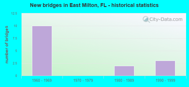
- New bridges - historical statistics
- 101960-1969
- 21980-1989
- 31990-1999


- Bridge Condition - Deck
- 28.6%Good
- 57.1%Satisfactory
- 14.3%Fair

- Bridge Condition - Superstructure
- 57.1%Good
- 42.9%Satisfactory

- Bridge Condition - Substructure
- 57.1%Good
- 42.9%Satisfactory

- Bridge Condition - Channel
- 66.7%Good
- 33.3%Satisfactory

- Bridge Condition - Culverts
- 33.3%Satisfactory
- 66.7%Poor
Find on map >> Show street view
Structure Number: 580062, Location: 9.5mi. East of SR281 (Lat: 30.618733, Lng: -86.963072), Route carried "on" structure: Interstate 10, Year Built: 1968, Status: Open, Structure Length: 4.64m (15.22ft), Average Daily Traffic: 15,250 (year 2020), Truck Traffic: 24%, Average Future Daily Traffic: 26,459 (year 2042), Design Load: HS 20, Features Intersected: SR87
Minimum Vertical Clearance: 30+ m (98+ ft), Kilometerpoint: 23.659, Lanes on structure: 2, Lanes under structure: 5, Base Highway Network: Yes, Owner: State Highway Agency, Approaching Roadway Width: 11.6m (38.1ft), Material/Design: Prestressed concrete, Design/Construction: Stringer/Multi-beam, Number Of Spans In Main Unit: 3, Length of Maximum Span: 23.9m (78.4ft), Curb-To-Curb Width: 12.2m (40.0ft), Out-to-Out Width: 13.1m (43.0ft)
Condition: Deck: Satisfactory, Superstructure: Satisfactory, Substructure: Good, Operating Rating: 87.1 metric tons, Method Used To Determine Operating Rating: Load Factor (LF), Inventory Rating: 51.7 metric tons, Method Used To Determine Inventory Rating: Load Factor (LF), Structural Evaluation: Equal to present minimum criteria, Deck Geometry: Better than present minimum criteria, Underclear: High priority of corrective action, Approach Roadway Alignment: Equal to present desirable criteria, Designated Inspection Frequency: Every 24 months, Inspection Date: July 2020, Deck Structure Type: Concrete Cast-file-Place
Find on map >> Show street view
Structure Number: 580078, Location: 2.9 Mi. West of SR87 (Lat: 30.593689, Lng: -87.000531), Route carried "on" structure: County highway 89, Year Built: 1968, Status: Open, Structure Length: 6.34m (20.80ft), Average Daily Traffic: 4,600 (year 2020), Truck Traffic: 9%, Average Future Daily Traffic: 7,981 (year 2042), Design Load: HS 20, Features Intersected: I10 SR8
Minimum Vertical Clearance: 30+ m (98+ ft), Kilometerpoint: 4.815, Lanes on structure: 2, Lanes under structure: 6, Owner: State Highway Agency, Approaching Roadway Width: 6.7m (22.0ft), Skew: 20 degrees, Material/Design: Prestressed concrete, Design/Construction: Stringer/Multi-beam, Number Of Spans In Main Unit: 2, Length of Maximum Span: 31.7m (104.0ft), Curb-To-Curb Width: 8.5m (27.9ft), Out-to-Out Width: 10.8m (35.4ft)
Condition: Deck: Satisfactory, Superstructure: Good, Substructure: Good, Inventory Rating: 73.5 metric tons, Method Used To Determine Inventory Rating: Load Factor (LF), Structural Evaluation: Better than present minimum criteria, Deck Geometry: High priority of corrective action, Underclear: Equal to present minimum criteria, Approach Roadway Alignment: Equal to present desirable criteria, Designated Inspection Frequency: Every 24 months, Inspection Date: July 2020, Deck Structure Type: Concrete Cast-file-Place
Find on map >> Show street view
Structure Number: 580079, Location: 2.0mi West of SR87 (Lat: 30.601211, Lng: -86.990750), Route carried "on" structure: Interstate 10, Year Built: 1968, Year Reconstructed: 1996, Status: Open, Structure Length: 0.86m (2.82ft), Average Daily Traffic: 40,500 (year 2020), Truck Traffic: 22%, Average Future Daily Traffic: 70,268 (year 2042), Design Load: HS 20, Features Intersected: Persimmon Hollow
Minimum Vertical Clearance: 30+ m (98+ ft), Kilometerpoint: 20.357, Lanes on structure: 4, Base Highway Network: Yes, Owner: State Highway Agency, Approaching Roadway Width: 23.2m (76.1ft), Skew: 10 degrees, Material/Design: Concrete, Design/Construction: Culvert, Number Of Spans In Main Unit: 3, Length of Maximum Span: 2.7m (8.9ft)
Condition: Channel: Good, Culverts: Satisfactory, Operating Rating: 67.1 metric tons, Method Used To Determine Operating Rating: Load Factor (LF), Inventory Rating: 39.9 metric tons, Method Used To Determine Inventory Rating: Load Factor (LF), Structural Evaluation: Equal to present minimum criteria, Waterway Adequacy: Equal to present desirable criteria, Approach Roadway Alignment: Equal to present desirable criteria, Designated Inspection Frequency: Every 24 months, Inspection Date: July 2020
Find on map >> Show street view
Structure Number: 58008, Location: 9.5mi East of SR281 (Lat: 30.618961, Lng: -86.963192), Route carried "on" structure: Interstate 10, Year Built: 1968, Year Reconstructed: 1995, Status: Open, Structure Length: 4.64m (15.22ft), Average Daily Traffic: 15,250 (year 2020), Truck Traffic: 24%, Average Future Daily Traffic: 26,459 (year 2042), Design Load: HS 20, Features Intersected: SR87
Minimum Vertical Clearance: 30+ m (98+ ft), Kilometerpoint: 23.659, Lanes on structure: 2, Lanes under structure: 5, Base Highway Network: Yes, Owner: State Highway Agency, Approaching Roadway Width: 11.6m (38.1ft), Material/Design: Prestressed concrete, Design/Construction: Stringer/Multi-beam, Number Of Spans In Main Unit: 3, Length of Maximum Span: 23.9m (78.4ft), Curb-To-Curb Width: 12.2m (40.0ft), Out-to-Out Width: 13.1m (43.0ft)
Condition: Deck: Satisfactory, Superstructure: Good, Substructure: Satisfactory, Operating Rating: 87.1 metric tons, Method Used To Determine Operating Rating: Load Factor (LF), Inventory Rating: 51.7 metric tons, Method Used To Determine Inventory Rating: Load Factor (LF), Structural Evaluation: Equal to present minimum criteria, Deck Geometry: Better than present minimum criteria, Underclear: High priority of corrective action, Approach Roadway Alignment: Equal to present desirable criteria, Designated Inspection Frequency: Every 24 months, Inspection Date: July 2020, Deck Structure Type: Concrete Cast-file-Place
Find on map >> Show street view
Structure Number: 580081, Location: 3.0Mi. East of SR87 (Lat: 30.636861, Lng: -86.917361), Route carried "on" structure: County highway , Year Built: 1968, Status: Open, Structure Length: 6.43m (21.10ft), Average Daily Traffic: 100 (year 2010), Average Future Daily Traffic: 135 (year 2032), Design Load: HS 20, Features Intersected: I10 SR8, Facility Carried by Structure: Jones Road
Minimum Vertical Clearance: 30+ m (98+ ft), Kilometerpoint: 1.102, Lanes on structure: 2, Lanes under structure: 4, Owner: State Highway Agency, Approaching Roadway Width: 7.3m (24.0ft), Skew: 1 degrees, Material/Design: Prestressed concrete, Design/Construction: Stringer/Multi-beam, Number Of Spans In Main Unit: 2, Length of Maximum Span: 32.2m (105.6ft), Curb or Sidewalk Widths: Left: 0.8m (2.6ft), Right: 0.8m (2.6ft), Curb-To-Curb Width: 7.3m (24.0ft), Out-to-Out Width: 9.0m (29.5ft)
Condition: Deck: Good, Superstructure: Satisfactory, Substructure: Good, Inventory Rating: 69.9 metric tons, Method Used To Determine Inventory Rating: Load Factor (LF), Structural Evaluation: Equal to present minimum criteria, Deck Geometry: Equal to present minimum criteria, Underclear: Somewhat better than minimum adequacy, Approach Roadway Alignment: Equal to present desirable criteria, Designated Inspection Frequency: Every 24 months, Inspection Date: August 2020, Deck Structure Type: Concrete Cast-file-Place
Find on map >> Show street view
Structure Number: 580094, Location: 4.2Miles South of I10 SR8 (Lat: 30.569333, Lng: -86.923806), Route carried "on" structure: State highway 87, Year Built: 1984, Status: Open, Structure Length: 144.82m (475.13ft), Average Daily Traffic: 5,800 (year 2020), Truck Traffic: 13%, Average Future Daily Traffic: 10,063 (year 2042), Design Load: HS 20, Features Intersected: Yellow River
Minimum Vertical Clearance: 30+ m (98+ ft), Kilometerpoint: 23.097, Lanes on structure: 2, Base Highway Network: Yes, Owner: State Highway Agency, Approaching Roadway Width: 10.4m (34.1ft), Material/Design: Prestressed concrete, Design/Construction: Stringer/Multi-beam, Number Of Spans In Main Unit: 63, Length of Maximum Span: 23.0m (75.5ft), Curb-To-Curb Width: 13.4m (44.0ft), Out-to-Out Width: 14.2m (46.6ft)
Condition: Deck: Fair, Superstructure: Good, Substructure: Satisfactory, Channel: Good, Operating Rating: 58.1 metric tons, Method Used To Determine Operating Rating: Load Factor (LF), Inventory Rating: 34.5 metric tons, Method Used To Determine Inventory Rating: Load Factor (LF), Structural Evaluation: Equal to present minimum criteria, Deck Geometry: Superior to present desirable criteria, Waterway Adequacy: Better than present minimum criteria, Approach Roadway Alignment: Equal to present desirable criteria, Designated Inspection Frequency: Every 24 months, Underwater Inspection Frequency: Every 24 months, Inspection Date: October 2020, Underwater Inspection Date: October 2020, Deck Structure Type: Concrete Cast-file-Place
Find on map >> Show street view
Structure Number: 584166, Location: .2 Mi W of N Airport Rd (Lat: 30.649267, Lng: -86.997544), Route carried "on" structure: County highway , Year Built: 1995, Status: Open, Structure Length: 1.52m (4.99ft), Average Daily Traffic: 75 (year 2020), Average Future Daily Traffic: 130 (year 2042), Features Intersected: Wrights Basin, Facility Carried by Structure: River Road
Minimum Vertical Clearance: 30+ m (98+ ft), Kilometerpoint: 0.504, Lanes on structure: 2, Owner: County Highway Agency, Approaching Roadway Width: 5.5m (18.0ft), Material/Design: Wood or Timber, Design/Construction: Stringer/Multi-beam, Number Of Spans In Main Unit: 5, Length of Maximum Span: 3.1m (10.2ft), Curb or Sidewalk Widths: Left: 0.1m (0.3ft), Right: 0.1m (0.3ft), Curb-To-Curb Width: 7.0m (23.0ft), Out-to-Out Width: 7.3m (24.0ft)
Condition: Deck: Satisfactory, Superstructure: Good, Substructure: Good, Channel: Good, Operating Rating: 34.5 metric tons, Method Used To Determine Operating Rating: Allowable Stress (AS), Inventory Rating: 25.4 metric tons, Method Used To Determine Inventory Rating: Allowable Stress (AS), Structural Evaluation: Equal to present minimum criteria, Deck Geometry: Somewhat better than minimum adequacy, Waterway Adequacy: Equal to present desirable criteria, Approach Roadway Alignment: Equal to present minimum criteria, Designated Inspection Frequency: Every 24 months, Inspection Date: January 2021, Deck Structure Type: Wood or Timber
Find on map >> Show street view
Structure Number: 584218, Location: 1.87Mi South of I-10 (Lat: 30.574167, Lng: -86.981389), Route carried "on" structure: County highway 89, Year Built: 1999, Status: Open, Structure Length: 0.78m (2.56ft), Average Daily Traffic: 4,300 (year 2020), Truck Traffic: 8%, Average Future Daily Traffic: 7,461 (year 2042), Design Load: HL 93, Features Intersected: Unnamed Bayou, Facility Carried by Structure: Ward Basin Road
Minimum Vertical Clearance: 30+ m (98+ ft), Kilometerpoint: 1.793, Lanes on structure: 2, Owner: County Highway Agency, Approaching Roadway Width: 6.5m (21.3ft), Material/Design: Aluminum, Iron, Design/Construction: Culvert, Number Of Spans In Main Unit: 1, Length of Maximum Span: 7.8m (25.6ft)
Condition: Channel: Satisfactory, Culverts: Poor, Operating Rating: 42.6 metric tons, Method Used To Determine Operating Rating: Load and Resistance Factor (LRFR), Inventory Rating: 32.7 metric tons, Method Used To Determine Inventory Rating: Load and Resistance Factor (LRFR), Structural Evaluation: Meets minimum limits, Waterway Adequacy: Better than present minimum criteria, Approach Roadway Alignment: Equal to present desirable criteria, Designated Inspection Frequency: Every 24 months, Other Special Inspection Frequency: Every 12 months, Inspection Date: April 2020, Other Special Inspection Date: April 2021
Find on map >> Show street view
Structure Number: 58422, Location: 1.3 Mi South of I-10 (Lat: 30.581389, Lng: -86.984444), Route carried "on" structure: County highway 89, Year Built: 1999, Status: Open, Structure Length: 0.69m (2.26ft), Average Daily Traffic: 4,300 (year 2020), Truck Traffic: 8%, Average Future Daily Traffic: 7,461 (year 2042), Design Load: HL 93, Features Intersected: Unnamed Branch, Facility Carried by Structure: Ward Basin Road
Minimum Vertical Clearance: 30+ m (98+ ft), Kilometerpoint: 2.651, Lanes on structure: 2, Owner: County Highway Agency, Approaching Roadway Width: 6.4m (21.0ft), Material/Design: Steel, Design/Construction: Culvert, Number Of Spans In Main Unit: 3, Length of Maximum Span: 2.4m (7.9ft)
Condition: Channel: Satisfactory, Culverts: Poor, Structural Evaluation: Meets minimum limits, Waterway Adequacy: Better than present minimum criteria, Approach Roadway Alignment: Equal to present desirable criteria, Designated Inspection Frequency: Every 24 months, Other Special Inspection Frequency: Every 6 months, Inspection Date: April 2020, Other Special Inspection Date: October 2021
Find on map >> Show street view
Structure Number: AFFLFTFA12222, Location: 4 MILE EAST OF U.S. 87 (Lat: 30.565000, Lng: -86.868667), Route carried "on" structure: Federal lands road 211, Year Built: 1965, Status: Open, Structure Length: 2.22m (7.28ft), Average Daily Traffic: 50 (year 2021), Average Future Daily Traffic: 55 (year 2041), Features Intersected: BOILING CREEK
Minimum Vertical Clearance: 30+ m (98+ ft), Kilometerpoint: 0.000, Lanes on structure: 1, Owner: Air Force, Approaching Roadway Width: 4.9m (16.1ft), Material/Design: Wood or Timber, Design/Construction: Stringer/Multi-beam, Number Of Spans In Main Unit: 6, Length of Maximum Span: 3.8m (12.5ft), Curb-To-Curb Width: 3.7m (12.1ft), Out-to-Out Width: 4.9m (16.1ft)
Condition: Deck: Good, Superstructure: Satisfactory, Substructure: Satisfactory, Channel: Good, Operating Rating: 10.9 metric tons, Method Used To Determine Operating Rating: Allowable Stress (AS), Inventory Rating: 7.3 metric tons, Method Used To Determine Inventory Rating: Allowable Stress (AS), Structural Evaluation: High priority of corrective action, Deck Geometry: Meets minimum limits, Waterway Adequacy: Equal to present minimum criteria, Approach Roadway Alignment: Equal to present desirable criteria, Bridge Posting: Required (Relationship of Operating Rating to Maximum Legal Load: 30.0 - 39.9% below), Designated Inspection Frequency: Every 24 months, Inspection Date: October 2021, Deck Structure Type: Wood or Timber, Wearing Surface/Protective System: Wearing Surface: Wood or Timber
Find on map >> Show street view
Structure Number: 580062, Location: 9.5mi. East of SR281 (Lat: 30.618733, Lng: -86.963072), Route carried "under" structure: State highway 87, Year Built: 1968, Structure Length: 0. m, Average Daily Traffic: 12,800 (year 2020), Truck Traffic: 13%, Features Intersected: SR87, Facility Carried by Structure: I10 SR8
Minimum Vertical Clearance: 5.18m (16.99ft), Kilometerpoint: 29.836, Lanes on structure: 2, Lanes under structure: 5, Material/Design: Prestressed concrete, Design/Construction: Stringer/Multi-beam, Length of Maximum Span: 23.9m (78.4ft)
Find on map >> Show street view
Structure Number: 580078, Location: 2.9 Mi. West of SR87 (Lat: 30.593689, Lng: -87.000531), Route carried "under" structure: Interstate 10, Year Built: 1968, Structure Length: 0. m, Average Daily Traffic: 40,500 (year 2020), Truck Traffic: 22%, Features Intersected: I10 SR8, Facility Carried by Structure: CR89 Ward Basin Rd
Minimum Vertical Clearance: 4.97m (16.31ft), Kilometerpoint: 19.087, Lanes on structure: 2, Lanes under structure: 6, Material/Design: Prestressed concrete, Design/Construction: Stringer/Multi-beam, Length of Maximum Span: 31.7m (104.0ft)
Find on map >> Show street view
Structure Number: 58008, Location: 9.5mi East of SR281 (Lat: 30.618961, Lng: -86.963192), Route carried "under" structure: State highway 87, Year Built: 1968, Structure Length: 0. m, Average Daily Traffic: 12,800 (year 2020), Truck Traffic: 13%, Features Intersected: SR87, Facility Carried by Structure: I10 SR8
Minimum Vertical Clearance: 5.03m (16.50ft), Kilometerpoint: 29.865, Lanes on structure: 2, Lanes under structure: 5, Material/Design: Prestressed concrete, Design/Construction: Stringer/Multi-beam, Length of Maximum Span: 23.9m (78.4ft)
Find on map >> Show street view
Structure Number: 580081, Location: 3.0Mi. East of SR87 (Lat: 30.636861, Lng: -86.917361), Route carried "under" structure: Interstate 10, Year Built: 1968, Structure Length: 0. m, Average Daily Traffic: 30,500 (year 2020), Truck Traffic: 24%, Features Intersected: I10 SR8, Facility Carried by Structure: Jones Road
Minimum Vertical Clearance: 4.97m (16.31ft), Kilometerpoint: 28.518, Lanes on structure: 2, Lanes under structure: 4, Material/Design: Prestressed concrete, Design/Construction: Stringer/Multi-beam, Length of Maximum Span: 32.2m (105.6ft)
Find on map >> Show street view
Structure Number: 5801, Location: 2.9 mi. West of SR87 (Lat: 30.593636, Lng: -87.000603), Route carried "under" structure: Interstate 10, Year Built: 1985, Structure Length: 0. m, Average Daily Traffic: 24,000 (year 2010), Truck Traffic: 34%, Features Intersected: I10 SR8, Facility Carried by Structure: CR89 Ward Basin Rd
Minimum Vertical Clearance: 4.97m (16.31ft), Kilometerpoint: 19.108, Lanes on structure: 2, Lanes under structure: 6, Material/Design: Prestressed concrete, Design/Construction: Stringer/Multi-beam, Length of Maximum Span: 31.7m (104.0ft)