Bridge Statistics for Durango, Colorado (CO)
Condition, Traffic, Stress, Structural Evaluation, Project Costs
- National Bridge Inventory (NBI) Statistics
- 30Number of bridges
- 407ft / 124mTotal length
- $285,000Total costs
- 292,627Total average daily traffic
- 12,869Total average daily truck traffic
- National Bridge Inventory (NBI) Registered Bridges for Durango
- No street view available for this location
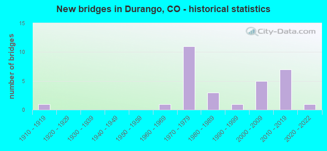
- New bridges - historical statistics
- 11910-1919
- 11960-1969
- 111970-1979
- 31980-1989
- 11990-1999
- 52000-2009
- 72010-2019
- 12020-2022

- Reconstructed bridges - Historical Statistics
- 11960-1969
- 21970-1979
- 01980-1989
- 01990-1999
- 12000-2009


- Bridge Condition - Deck
- 10.5%Very good
- 57.9%Good
- 26.3%Satisfactory
- 5.3%Fair

- Bridge Condition - Superstructure
- 15.8%Very good
- 42.1%Good
- 26.3%Satisfactory
- 15.8%Fair

- Bridge Condition - Substructure
- 10.5%Very good
- 63.2%Good
- 15.8%Satisfactory
- 10.5%Fair

- Bridge Condition - Channel
- 48.1%Very good
- 29.6%Good
- 22.2%Satisfactory

- Bridge Condition - Culverts
- 12.5%Very good
- 50.0%Good
- 25.0%Satisfactory
- 12.5%Fair
Find on map >> Show street view
Structure Number: 405-234, Location: 4 miles E of Durango CO (Lat: 37.294475, Lng: -107.794758), Route carried "on" structure: ServiceCounty highway 234, Year Built: 1980, Status: Open, Structure Length: 1.04m (3.41ft), Average Daily Traffic: 250 (year 2006), Average Future Daily Traffic: 250 (year 2035), Design Load: HS 20, Features Intersected: Florida Canal
Minimum Vertical Clearance: 30+ m (98+ ft), Kilometerpoint: 0.000, Lanes on structure: 2, Owner: Bureau of Reclamation, Maintenance Responsibility: County Highway Agency, Approaching Roadway Width: 7.6m (24.9ft), Skew: 2 degrees, Material/Design: Steel, Design/Construction: Stringer/Multi-beam, Number Of Spans In Main Unit: 1, Length of Maximum Span: 9.8m (32.2ft), Curb-To-Curb Width: 7.3m (24.0ft), Out-to-Out Width: 7.3m (24.0ft)
Condition: Deck: Fair, Superstructure: Satisfactory, Substructure: Good, Channel: Good, Operating Rating: 53.1 metric tons, Method Used To Determine Operating Rating: Load Factor (LF), Inventory Rating: 31.5 metric tons, Method Used To Determine Inventory Rating: Load Factor (LF), Structural Evaluation: Equal to present minimum criteria, Deck Geometry: Somewhat better than minimum adequacy, Waterway Adequacy: Equal to present desirable criteria, Approach Roadway Alignment: Better than present minimum criteria, Designated Inspection Frequency: Every 24 months, Inspection Date: November 2021, Deck Structure Type: Corrugated Steel, Wearing Surface/Protective System: Wearing Surface: Gravel
Find on map >> Show street view
Structure Number: 6701410.20033A, Location: JUST S OF SH160 (Lat: 37.264406, Lng: -107.922133), Route carried "on" structure: County highway , Year Built: 2006, Status: Open, Structure Length: 0.66m (2.17ft), Average Daily Traffic: 3,946 (year 2017), Truck Traffic: 5%, Average Future Daily Traffic: 5,800 (year 2037), Design Load: HS 20, Features Intersected: WILDCAT CANYON, Facility Carried by Structure: COUNTY ROAD 141
Minimum Vertical Clearance: 30+ m (98+ ft), Kilometerpoint: 18.352, Lanes on structure: 2, Owner: County Highway Agency, Approaching Roadway Width: 7.6m (24.9ft), Skew: 4 degrees, Material/Design: Concrete, Design/Construction: Culvert, Number Of Spans In Main Unit: 1, Length of Maximum Span: 6.6m (21.7ft), Curb-To-Curb Width: 9.8m (32.2ft), Out-to-Out Width: 15.4m (50.5ft)
Condition: Channel: Very good, Culverts: Very good, Operating Rating: 36.3 metric tons, Method Used To Determine Operating Rating: Field evaluation and documented engineering judgment, Inventory Rating: 32.7 metric tons, Method Used To Determine Inventory Rating: Field evaluation and documented engineering judgment, Structural Evaluation: Equal to present desirable criteria, Deck Geometry: Meets minimum limits, Waterway Adequacy: Equal to present desirable criteria, Approach Roadway Alignment: Better than present minimum criteria, Designated Inspection Frequency: Every 24 months, Inspection Date: October 2020
Find on map >> Show street view
Structure Number: 67020700.3025A, Location: .2 MI N OF SH 160 (Lat: 37.282992, Lng: -107.934642), Route carried "on" structure: County highway , Year Built: 2013, Status: Open, Structure Length: 1.32m (4.33ft), Average Daily Traffic: 748 (year 2017), Truck Traffic: 5%, Average Future Daily Traffic: 1,099 (year 2037), Design Load: HS 25 or greater, Features Intersected: LIGHTNER CREEK, Facility Carried by Structure: COUNTY ROAD 207
Minimum Vertical Clearance: 30.45m (99.90ft), Kilometerpoint: 0.480, Lanes on structure: 2, Owner: County Highway Agency, Approaching Roadway Width: 8.8m (28.9ft), Material/Design: Prestressed concrete, Design/Construction: Slab, Number Of Spans In Main Unit: 1, Length of Maximum Span: 12.2m (40.0ft), Curb-To-Curb Width: 9.8m (32.2ft), Out-to-Out Width: 10.1m (33.1ft)
Condition: Deck: Good, Superstructure: Good, Substructure: Good, Channel: Very good, Operating Rating: 36.3 metric tons, Method Used To Determine Operating Rating: Field evaluation and documented engineering judgment, Inventory Rating: 32.7 metric tons, Method Used To Determine Inventory Rating: Field evaluation and documented engineering judgment, Structural Evaluation: Better than present minimum criteria, Deck Geometry: Equal to present minimum criteria, Waterway Adequacy: Equal to present desirable criteria, Approach Roadway Alignment: Equal to present minimum criteria, Designated Inspection Frequency: Every 24 months, Inspection Date: October 2020, Deck Structure Type: Other, Wearing Surface/Protective System: Wearing Surface: Bituminous, Membrane: Other, Deck Protection: Epoxy Coated Reinforcing
Find on map >> Show street view
Structure Number: 67021313.62052, Location: .5 MI S OF SH 160 (Lat: 37.220589, Lng: -107.859478), Route carried "on" structure: County highway , Year Built: 2004, Status: Open, Structure Length: 14.48m (47.51ft), Average Daily Traffic: 3,987 (year 2017), Truck Traffic: 5%, Average Future Daily Traffic: 5,861 (year 2037), Design Load: HS 25 or greater, Features Intersected: ANIMAS RIVER, Facility Carried by Structure: COUNTY ROAD 213
Minimum Vertical Clearance: 30+ m (98+ ft), Kilometerpoint: 0.109, Lanes on structure: 2, Owner: County Highway Agency, Approaching Roadway Width: 9.8m (32.2ft), Skew: 1 degrees, Material/Design: Prestressed concrete continuous, Design/Construction: Stringer/Multi-beam, Number Of Spans In Main Unit: 4, Length of Maximum Span: 39.6m (129.9ft), Curb or Sidewalk Widths: Left: 2.1m (6.9ft), Right: 0.0m, Curb-To-Curb Width: 12.3m (40.4ft), Out-to-Out Width: 15.3m (50.2ft)
Condition: Deck: Good, Superstructure: Good, Substructure: Very good, Channel: Very good, Operating Rating: 66.9 metric tons, Method Used To Determine Operating Rating: Load Factor (LF), Inventory Rating: 40.1 metric tons, Method Used To Determine Inventory Rating: Load Factor (LF), Structural Evaluation: Better than present minimum criteria, Deck Geometry: Equal to present minimum criteria, Waterway Adequacy: Equal to present desirable criteria, Approach Roadway Alignment: Equal to present desirable criteria, Designated Inspection Frequency: Every 24 months, Inspection Date: October 2020, Deck Structure Type: Concrete Precast Panels, Wearing Surface/Protective System: Wearing Surface: Bituminous, Membrane: Built-up, Deck Protection: Epoxy Coated Reinforcing
Find on map >> Show street view
Structure Number: 67022801.8017A, Location: .3 MI SW OF CR 225 (Lat: 37.255586, Lng: -107.776694), Route carried "on" structure: County highway , Year Built: 1990, Status: Open, Structure Length: 2.29m (7.51ft), Average Daily Traffic: 1,118 (year 2017), Truck Traffic: 2%, Average Future Daily Traffic: 1,643 (year 2037), Features Intersected: FLORIDA RIVER, Facility Carried by Structure: COUNTY ROAD 228
Minimum Vertical Clearance: 30+ m (98+ ft), Kilometerpoint: 2.776, Lanes on structure: 2, Owner: County Highway Agency, Approaching Roadway Width: 8.2m (26.9ft), Skew: 3 degrees, Material/Design: Prestressed concrete, Design/Construction: Stringer/Multi-beam, Number Of Spans In Main Unit: 1, Length of Maximum Span: 21.3m (69.9ft), Curb-To-Curb Width: 8.5m (27.9ft), Out-to-Out Width: 9.4m (30.8ft)
Condition: Deck: Good, Superstructure: Very good, Substructure: Good, Channel: Good, Operating Rating: 72.1 metric tons, Method Used To Determine Operating Rating: Load Factor (LF), Inventory Rating: 43.3 metric tons, Method Used To Determine Inventory Rating: Load Factor (LF), Structural Evaluation: Better than present minimum criteria, Deck Geometry: Somewhat better than minimum adequacy, Waterway Adequacy: Equal to present desirable criteria, Approach Roadway Alignment: Somewhat better than minimum adequacy, Designated Inspection Frequency: Every 24 months, Inspection Date: October 2020, Deck Structure Type: Concrete Cast-file-Place, Wearing Surface/Protective System: Wearing Surface: Bituminous, Membrane: Built-up, Deck Protection: Epoxy Coated Reinforcing
Find on map >> Show street view
Structure Number: 67023402.1015A, Location: .2 MI S OF CR 237 (Lat: 37.287744, Lng: -107.795686), Route carried "on" structure: County highway , Year Built: 1986, Status: Open, Structure Length: 1.86m (6.10ft), Average Daily Traffic: 2,641 (year 2017), Truck Traffic: 5%, Average Future Daily Traffic: 3,883 (year 2037), Design Load: HS 20, Features Intersected: FLORIDA RIVER, Facility Carried by Structure: COUNTY ROAD 234
Minimum Vertical Clearance: 30+ m (98+ ft), Kilometerpoint: 6.924, Lanes on structure: 2, Owner: County Highway Agency, Approaching Roadway Width: 7.0m (23.0ft), Skew: 4 degrees, Material/Design: Prestressed concrete, Design/Construction: Tee Beam, Number Of Spans In Main Unit: 1, Length of Maximum Span: 17.5m (57.4ft), Curb-To-Curb Width: 9.8m (32.2ft), Out-to-Out Width: 10.5m (34.4ft)
Condition: Deck: Satisfactory, Superstructure: Satisfactory, Substructure: Good, Channel: Good, Operating Rating: 42.2 metric tons, Method Used To Determine Operating Rating: Load Factor (LF), Inventory Rating: 38.7 metric tons, Method Used To Determine Inventory Rating: Load Factor (LF), Structural Evaluation: Equal to present minimum criteria, Deck Geometry: Meets minimum limits, Waterway Adequacy: Equal to present desirable criteria, Approach Roadway Alignment: Somewhat better than minimum adequacy, Designated Inspection Frequency: Every 24 months, Inspection Date: October 2020, Deck Structure Type: Other, Wearing Surface/Protective System: Wearing Surface: Bituminous
Find on map >> Show street view
Structure Number: 67023403.0016A, Location: ,2 MI SW OF CR 225 (Lat: 37.276283, Lng: -107.793278), Route carried "on" structure: County highway , Year Built: 2006, Status: Open, Structure Length: 0.82m (2.69ft), Average Daily Traffic: 2,197 (year 2017), Truck Traffic: 5%, Average Future Daily Traffic: 3,230 (year 2037), Design Load: HS 20, Features Intersected: FLORIDA RIVER, Facility Carried by Structure: COUNTY ROAD 234
Minimum Vertical Clearance: 30+ m (98+ ft), Kilometerpoint: 5.395, Lanes on structure: 2, Owner: County Highway Agency, Approaching Roadway Width: 11.0m (36.1ft), Skew: 2 degrees, Material/Design: Concrete, Design/Construction: Culvert, Number Of Spans In Main Unit: 1, Length of Maximum Span: 8.2m (26.9ft), Curb-To-Curb Width: 10.6m (34.8ft), Out-to-Out Width: 17.4m (57.1ft)
Condition: Channel: Satisfactory, Culverts: Good, Operating Rating: 36.3 metric tons, Method Used To Determine Operating Rating: Field evaluation and documented engineering judgment, Inventory Rating: 32.7 metric tons, Method Used To Determine Inventory Rating: Field evaluation and documented engineering judgment, Structural Evaluation: Better than present minimum criteria, Deck Geometry: Somewhat better than minimum adequacy, Waterway Adequacy: Better than present minimum criteria, Approach Roadway Alignment: Better than present minimum criteria, Designated Inspection Frequency: Every 24 months, Inspection Date: October 2020
Find on map >> Show street view
Structure Number: DURANGO-001, Location: 250' W OF SH 550 (Lat: 37.274244, Lng: -107.884500), Route carried "on" structure: City street , Year Built: 1979, Status: Open, Structure Length: 6.54m (21.46ft), Average Daily Traffic: 5,236 (year 2018), Truck Traffic: 7%, Average Future Daily Traffic: 7,697 (year 2038), Design Load: HS 20, Features Intersected: ANIMAS RIVER, Facility Carried by Structure: 9TH STREET
Minimum Vertical Clearance: 30+ m (98+ ft), Kilometerpoint: 0.048, Lanes on structure: 2, Owner: City or Municipal Highway Agency, Approaching Roadway Width: 9.1m (29.9ft), Skew: 2 degrees, Material/Design: Steel continuous, Design/Construction: Stringer/Multi-beam, Number Of Spans In Main Unit: 2, Length of Maximum Span: 31.6m (103.7ft), Curb or Sidewalk Widths: Left: 2.4m (7.9ft), Right: 0.0m, Curb-To-Curb Width: 9.2m (30.2ft), Out-to-Out Width: 12.6m (41.3ft)
Condition: Deck: Good, Superstructure: Good, Substructure: Good, Channel: Good, Operating Rating: 50.4 metric tons, Method Used To Determine Operating Rating: Load Factor (LF), Inventory Rating: 30.2 metric tons, Method Used To Determine Inventory Rating: Load Factor (LF), Structural Evaluation: Better than present minimum criteria, Deck Geometry: Meets minimum limits, Waterway Adequacy: Equal to present desirable criteria, Approach Roadway Alignment: Equal to present desirable criteria, Designated Inspection Frequency: Every 24 months, Inspection Date: October 2020, Deck Structure Type: Concrete Cast-file-Place, Wearing Surface/Protective System: Wearing Surface: Bituminous
Find on map >> Show street view
Structure Number: DURANGO-003, Location: .2 MI E OF SH 550 (Lat: 37.300083, Lng: -107.868906), Route carried "on" structure: City street , Year Built: 1974, Status: Open, Structure Length: 4.54m (14.90ft), Average Daily Traffic: 5,484 (year 2018), Truck Traffic: 7%, Average Future Daily Traffic: 8,062 (year 2038), Design Load: HS 20, Features Intersected: ANIMAS RIVER, Facility Carried by Structure: 32ND STREET
Minimum Vertical Clearance: 30+ m (98+ ft), Kilometerpoint: 0.504, Lanes on structure: 3, Owner: City or Municipal Highway Agency, Approaching Roadway Width: 13.4m (44.0ft), Material/Design: Steel continuous, Design/Construction: Stringer/Multi-beam, Number Of Spans In Main Unit: 2, Length of Maximum Span: 21.3m (69.9ft), Curb or Sidewalk Widths: Left: 1.4m (4.6ft), Right: 1.4m (4.6ft), Curb-To-Curb Width: 13.4m (44.0ft), Out-to-Out Width: 17.1m (56.1ft)
Condition: Deck: Good, Superstructure: Good, Substructure: Good, Channel: Good, Operating Rating: 59.8 metric tons, Method Used To Determine Operating Rating: Load Factor (LF), Inventory Rating: 35.8 metric tons, Method Used To Determine Inventory Rating: Load Factor (LF), Structural Evaluation: Better than present minimum criteria, Deck Geometry: Somewhat better than minimum adequacy, Waterway Adequacy: Equal to present desirable criteria, Approach Roadway Alignment: Equal to present desirable criteria, Designated Inspection Frequency: Every 24 months, Inspection Date: October 2020, Deck Structure Type: Concrete Cast-file-Place, Wearing Surface/Protective System: Wearing Surface: Bituminous
Find on map >> Show street view
Structure Number: DURANGO-004, Location: 1.0 MI W OF HWY 550 (Lat: 37.270142, Lng: -107.900250), Route carried "on" structure: City street , Year Built: 1978, Status: Open, Structure Length: 0.79m (2.59ft), Average Daily Traffic: 186 (year 2017), Truck Traffic: 5%, Average Future Daily Traffic: 273 (year 2037), Features Intersected: LIGHTNER CREEK, Facility Carried by Structure: PERINS CANYON DR
Minimum Vertical Clearance: 30+ m (98+ ft), Kilometerpoint: 0.023, Lanes on structure: 2, Owner: City or Municipal Highway Agency, Approaching Roadway Width: 7.9m (25.9ft), Material/Design: Steel, Design/Construction: Stringer/Multi-beam, Number Of Spans In Main Unit: 1, Length of Maximum Span: 7.3m (24.0ft), Curb-To-Curb Width: 9.8m (32.2ft), Out-to-Out Width: 9.8m (32.2ft)
Condition: Deck: Satisfactory, Superstructure: Satisfactory, Substructure: Fair, Channel: Satisfactory, Operating Rating: 38.3 metric tons, Method Used To Determine Operating Rating: Load Factor (LF), Inventory Rating: 23.0 metric tons, Method Used To Determine Inventory Rating: Load Factor (LF), Structural Evaluation: Somewhat better than minimum adequacy, Deck Geometry: Better than present minimum criteria, Waterway Adequacy: Better than present minimum criteria, Approach Roadway Alignment: Equal to present minimum criteria, Designated Inspection Frequency: Every 24 months, Inspection Date: October 2020, Deck Structure Type: Corrugated Steel, Wearing Surface/Protective System: Wearing Surface: Bituminous
Find on map >> Show street view
Structure Number: DURANGO-005, Location: 0.6 MI N of US160 (Lat: 37.233044, Lng: -107.823275), Route carried "on" structure: City street , Year Built: 2004, Status: Open, Structure Length: 0.63m (2.07ft), Average Daily Traffic: 1,000 (year 2018), Truck Traffic: 3%, Average Future Daily Traffic: 1,510 (year 2038), Design Load: HS 20, Features Intersected: TRAVERSE WASH, Facility Carried by Structure: THREE SPRINGS BLVD
Minimum Vertical Clearance: 30+ m (98+ ft), Kilometerpoint: 0.020, Lanes on structure: 4, Owner: City or Municipal Highway Agency, Approaching Roadway Width: 9.8m (32.2ft), Skew: 30 degrees, Material/Design: Concrete, Design/Construction: Culvert, Number Of Spans In Main Unit: 2, Length of Maximum Span: 3.0m (9.8ft), Curb or Sidewalk Widths: Left: 3.0m (9.8ft), Right: 3.0m (9.8ft), Out-to-Out Width: 87.7m (287.7ft)
Condition: Channel: Very good, Culverts: Good, Operating Rating: 36.3 metric tons, Method Used To Determine Operating Rating: Field evaluation and documented engineering judgment, Inventory Rating: 32.7 metric tons, Method Used To Determine Inventory Rating: Field evaluation and documented engineering judgment, Structural Evaluation: Better than present minimum criteria, Waterway Adequacy: Equal to present desirable criteria, Approach Roadway Alignment: Equal to present desirable criteria, Designated Inspection Frequency: Every 24 months, Inspection Date: October 2020
Find on map >> Show street view
Structure Number: DURANGO-006, Location: 0.8 MI N of US160 (Lat: 37.237044, Lng: -107.820714), Route carried "on" structure: City street , Year Built: 2004, Status: Open, Structure Length: 0.70m (2.30ft), Average Daily Traffic: 1,000 (year 2018), Truck Traffic: 3%, Average Future Daily Traffic: 1,510 (year 2038), Features Intersected: TRAVERSE WASH, Facility Carried by Structure: CONFLUENCE AVE
Minimum Vertical Clearance: 30+ m (98+ ft), Kilometerpoint: 0.016, Lanes on structure: 2, Owner: City or Municipal Highway Agency, Approaching Roadway Width: 20.1m (65.9ft), Material/Design: Concrete, Design/Construction: Culvert, Number Of Spans In Main Unit: 2, Length of Maximum Span: 3.7m (12.1ft), Curb or Sidewalk Widths: Left: 3.0m (9.8ft), Right: 3.0m (9.8ft), Out-to-Out Width: 28.9m (94.8ft)
Condition: Channel: Very good, Culverts: Good, Operating Rating: 36.3 metric tons, Method Used To Determine Operating Rating: Field evaluation and documented engineering judgment, Inventory Rating: 32.7 metric tons, Method Used To Determine Inventory Rating: Field evaluation and documented engineering judgment, Structural Evaluation: Better than present minimum criteria, Waterway Adequacy: Equal to present desirable criteria, Approach Roadway Alignment: Equal to present desirable criteria, Designated Inspection Frequency: Every 24 months, Inspection Date: October 2020
Find on map >> Show street view
Structure Number: DURANGO-007, Location: 0.1 Mi N of US160 (Lat: 37.269789, Lng: -107.926639), Route carried "on" structure: City street , Year Built: 2020, Status: Open, Structure Length: 2.08m (6.82ft), Average Daily Traffic: 125 (year 2020), Average Future Daily Traffic: 212 (year 2037), Design Load: HS 20, Features Intersected: Lightner Creek, Facility Carried by Structure: Tipple Ave.
Minimum Vertical Clearance: 30+ m (98+ ft), Kilometerpoint: 0.061, Lanes on structure: 2, Owner: City or Municipal Highway Agency, Approaching Roadway Width: 7.3m (24.0ft), Skew: 1 degrees, Material/Design: Steel, Design/Construction: Stringer/Multi-beam, Number Of Spans In Main Unit: 1, Length of Maximum Span: 19.8m (65.0ft), Curb-To-Curb Width: 8.8m (28.9ft), Out-to-Out Width: 9.6m (31.5ft)
Condition: Deck: Good, Superstructure: Good, Substructure: Very good, Channel: Very good, Operating Rating: 25.9 metric tons, Method Used To Determine Operating Rating: Load and Resistance Factor Rating (LRFR) rating reported by rating factor(RF) method using HL-93 loadings, Inventory Rating: 20.1 metric tons, Method Used To Determine Inventory Rating: Load and Resistance Factor Rating (LRFR) rating reported by rating factor(RF) method using HL-93 loadings, Structural Evaluation: Somewhat better than minimum adequacy, Deck Geometry: Equal to present minimum criteria, Waterway Adequacy: Equal to present desirable criteria, Approach Roadway Alignment: Equal to present minimum criteria, Designated Inspection Frequency: Every 24 months, Inspection Date: October 2020, Deck Structure Type: Concrete Cast-file-Place, Wearing Surface/Protective System: Wearing Surface: Monolithic Concrete
Find on map >> Show street view
Structure Number: DURANGO-02A, Location: JUST N OF 24TH STREET (Lat: 37.290414, Lng: -107.876394), Route carried "on" structure: City street , Year Built: 1989, Status: Open, Structure Length: 1.28m (4.20ft), Average Daily Traffic: 659 (year 2018), Truck Traffic: 5%, Average Future Daily Traffic: 969 (year 2038), Features Intersected: JUNCTION CREEK, Facility Carried by Structure: 2ND AVENUE
Minimum Vertical Clearance: 30+ m (98+ ft), Kilometerpoint: 1.065, Lanes on structure: 2, Owner: City or Municipal Highway Agency, Approaching Roadway Width: 12.1m (39.7ft), Skew: 4 degrees, Material/Design: Steel, Design/Construction: Stringer/Multi-beam, Number Of Spans In Main Unit: 1, Length of Maximum Span: 11.9m (39.0ft), Curb or Sidewalk Widths: Left: 1.6m (5.2ft), Right: 0.0m, Curb-To-Curb Width: 12.3m (40.4ft), Out-to-Out Width: 14.1m (46.3ft)
Condition: Deck: Good, Superstructure: Good, Substructure: Good, Channel: Satisfactory, Operating Rating: 52.0 metric tons, Method Used To Determine Operating Rating: Load Factor (LF), Inventory Rating: 31.2 metric tons, Method Used To Determine Inventory Rating: Load Factor (LF), Structural Evaluation: Better than present minimum criteria, Deck Geometry: Superior to present desirable criteria, Waterway Adequacy: Equal to present desirable criteria, Approach Roadway Alignment: Equal to present desirable criteria, Designated Inspection Frequency: Every 48 months, Inspection Date: October 2020, Deck Structure Type: Concrete Cast-file-Place, Wearing Surface/Protective System: Wearing Surface: Bituminous
Find on map >> Show street view
Structure Number: O-05-AJ, Location: INT. OF 550 & 160 (Lat: 37.268386, Lng: -107.886325), Route carried "on" structure: US 160A, Year Built: 1968, Status: Open, Structure Length: 5.67m (18.60ft), Average Daily Traffic: 17,000 (year 2020), Truck Traffic: 5%, Average Future Daily Traffic: 20,060 (year 2040), Design Load: HS 20+Mod, Features Intersected: ANIMAS RIVER, Facility Carried by Structure: US 160 ML
Minimum Vertical Clearance: 30+ m (98+ ft), Kilometerpoint: 133.973, Lanes on structure: 4, Base Highway Network: Yes, Owner: State Highway Agency, Approaching Roadway Width: 19.5m (64.0ft), Material/Design: Steel continuous, Design/Construction: Stringer/Multi-beam, Number Of Spans In Main Unit: 3, Length of Maximum Span: 20.9m (68.6ft), Curb-To-Curb Width: 19.2m (63.0ft), Out-to-Out Width: 20.0m (65.6ft)
Condition: Deck: Good, Superstructure: Satisfactory, Substructure: Satisfactory, Channel: Good, Operating Rating: 75.2 metric tons, Method Used To Determine Operating Rating: Load Factor (LF), Inventory Rating: 45.1 metric tons, Method Used To Determine Inventory Rating: Load Factor (LF), Structural Evaluation: Equal to present minimum criteria, Deck Geometry: Equal to present minimum criteria, Waterway Adequacy: Equal to present desirable criteria, Approach Roadway Alignment: Equal to present desirable criteria, Designated Inspection Frequency: Every 24 months, Inspection Date: October 2021, Deck Structure Type: Concrete Cast-file-Place, Wearing Surface/Protective System: Wearing Surface: Epoxy Overlay
Find on map >> Show street view
Structure Number: O-05-AK, Location: S.W. EDGE OF DURANGO (Lat: 37.270400, Lng: -107.895100), Route carried "on" structure: US 160A, Year Built: 1970, Status: Open, Structure Length: 0.99m (3.25ft), Average Daily Traffic: 19,000 (year 2020), Truck Traffic: 5%, Average Future Daily Traffic: 22,610 (year 2040), Design Load: HS 20, Features Intersected: LIGHTNER CREEK, Facility Carried by Structure: US 160 ML
Minimum Vertical Clearance: 30+ m (98+ ft), Kilometerpoint: 133.093, Lanes on structure: 5, Base Highway Network: Yes, Owner: State Highway Agency, Approaching Roadway Width: 27.9m (91.5ft), Skew: 4 degrees, Material/Design: Concrete, Design/Construction: Culvert, Number Of Spans In Main Unit: 2, Length of Maximum Span: 4.8m (15.7ft), Curb or Sidewalk Widths: Left: 2.4m (7.9ft), Right: 1.5m (4.9ft), Curb-To-Curb Width: 27.9m (91.5ft), Out-to-Out Width: 44.4m (145.7ft)
Condition: Channel: Satisfactory, Culverts: Satisfactory, Operating Rating: 36.3 metric tons, Method Used To Determine Operating Rating: Field evaluation and documented engineering judgment, Inventory Rating: 32.7 metric tons, Method Used To Determine Inventory Rating: Field evaluation and documented engineering judgment, Structural Evaluation: Equal to present minimum criteria, Deck Geometry: Superior to present desirable criteria, Waterway Adequacy: Equal to present minimum criteria, Approach Roadway Alignment: Equal to present desirable criteria, Designated Inspection Frequency: Every 24 months, Inspection Date: October 2021
Find on map >> Show street view
Structure Number: O-05-AL, Location: W. EDGE OF DURANGO (Lat: 37.270258, Lng: -107.904058), Route carried "on" structure: US 160A, Year Built: 1970, Status: Open, Structure Length: 0.73m (2.40ft), Average Daily Traffic: 12,000 (year 2020), Truck Traffic: 6%, Average Future Daily Traffic: 13,080 (year 2040), Design Load: HS 20, Features Intersected: LIGHTNER CREEK, Facility Carried by Structure: US 160 ML
Minimum Vertical Clearance: 30+ m (98+ ft), Kilometerpoint: 132.100, Lanes on structure: 5, Base Highway Network: Yes, Owner: State Highway Agency, Approaching Roadway Width: 27.9m (91.5ft), Skew: 4 degrees, Material/Design: Concrete, Design/Construction: Culvert, Number Of Spans In Main Unit: 2, Length of Maximum Span: 3.4m (11.2ft), Curb-To-Curb Width: 27.9m (91.5ft), Out-to-Out Width: 40.9m (134.2ft)
Condition: Channel: Satisfactory, Culverts: Fair, Operating Rating: 89.8 metric tons, Method Used To Determine Operating Rating: Field evaluation and documented engineering judgment, Inventory Rating: 89.8 metric tons, Method Used To Determine Inventory Rating: Field evaluation and documented engineering judgment, Structural Evaluation: Somewhat better than minimum adequacy, Deck Geometry: Superior to present desirable criteria, Waterway Adequacy: Equal to present desirable criteria, Approach Roadway Alignment: Equal to present desirable criteria, Designated Inspection Frequency: Every 24 months, Inspection Date: October 2021
Find on map >> Show street view
Structure Number: O-05-AM, Location: W. EDGE OF DURANGO (Lat: 37.268425, Lng: -107.913964), Route carried "on" structure: US 160A, Year Built: 1971, Year Reconstructed: 2014, Status: Open, Structure Length: 0.99m (3.25ft), Average Daily Traffic: 12,000 (year 2020), Truck Traffic: 6%, Average Future Daily Traffic: 13,080 (year 2040), Design Load: HS 20+Mod, Features Intersected: LIGHTNER CREEK, Facility Carried by Structure: US 160 ML
Minimum Vertical Clearance: 30+ m (98+ ft), Kilometerpoint: 131.376, Lanes on structure: 7, Base Highway Network: Yes, Owner: State Highway Agency, Approaching Roadway Width: 27.7m (90.9ft), Skew: 4 degrees, Material/Design: Concrete, Design/Construction: Culvert, Number Of Spans In Main Unit: 2, Length of Maximum Span: 4.7m (15.4ft), Out-to-Out Width: 42.5m (139.4ft)
Condition: Channel: Very good, Culverts: Satisfactory, Operating Rating: 36.3 metric tons, Method Used To Determine Operating Rating: Field evaluation and documented engineering judgment, Inventory Rating: 32.7 metric tons, Method Used To Determine Inventory Rating: Field evaluation and documented engineering judgment, Structural Evaluation: Equal to present minimum criteria, Waterway Adequacy: Equal to present desirable criteria, Approach Roadway Alignment: Equal to present desirable criteria, Designated Inspection Frequency: Every 24 months, Inspection Date: October 2021
Find on map >> Show street view
Structure Number: O-05-AQ, Location: 0.9 MI E OF JCT SH 550 (Lat: 37.258697, Lng: -107.876681), Route carried "on" structure: US 160A, Year Built: 1974, Year Reconstructed: 1983, Status: Open, Structure Length: 8.31m (27.26ft), Average Daily Traffic: 30,000 (year 2020), Truck Traffic: 3%, Average Future Daily Traffic: 36,000 (year 2040), Design Load: HS 20+Mod, Features Intersected: ANIMAS RIVER, Facility Carried by Structure: US 160 ML
Minimum Vertical Clearance: 30+ m (98+ ft), Kilometerpoint: 135.504, Lanes on structure: 4, Base Highway Network: Yes, Owner: State Highway Agency, Approaching Roadway Width: 26.2m (86.0ft), Skew: 33 degrees, Material/Design: Steel continuous, Design/Construction: Stringer/Multi-beam, Number Of Spans In Main Unit: 2, Length of Maximum Span: 40.8m (133.9ft), Curb or Sidewalk Widths: Left: 0.0m, Right: 1.4m (4.6ft), Curb-To-Curb Width: 25.0m (82.0ft), Out-to-Out Width: 28.0m (91.9ft)
Condition: Deck: Good, Superstructure: Fair, Substructure: Good, Channel: Good, Operating Rating: 60.0 metric tons, Method Used To Determine Operating Rating: Load Factor (LF), Inventory Rating: 35.9 metric tons, Method Used To Determine Inventory Rating: Load Factor (LF), Structural Evaluation: Somewhat better than minimum adequacy, Deck Geometry: Superior to present desirable criteria, Waterway Adequacy: Equal to present desirable criteria, Approach Roadway Alignment: Equal to present desirable criteria, Designated Inspection Frequency: Every 24 months, Underwater Inspection Frequency: Every 60 months, Inspection Date: October 2021, Underwater Inspection Date: August 2018, Deck Structure Type: Concrete Cast-file-Place, Wearing Surface/Protective System: Wearing Surface: Bituminous
Find on map >> Show street view
Structure Number: O-05-B, Location: W. EDGE OF DURANGO (Lat: 37.270339, Lng: -107.901586), Route carried "on" structure: ServiceUS 160A, Year Built: 1970, Status: Open, Structure Length: 0.70m (2.30ft), Average Daily Traffic: 12,000 (year 2020), Truck Traffic: 6%, Average Future Daily Traffic: 13,080 (year 2040), Design Load: H 20, Features Intersected: LIGHTNER CREEK AR, Facility Carried by Structure: PRIVATE LAND ACESS
Minimum Vertical Clearance: 30+ m (98+ ft), Kilometerpoint: 132.245, Lanes on structure: 2, Base Highway Network: Yes, Owner: State Highway Agency, Approaching Roadway Width: 4.6m (15.1ft), Skew: 1 degrees, Material/Design: Concrete, Design/Construction: Culvert, Number Of Spans In Main Unit: 2, Length of Maximum Span: 3.4m (11.2ft), Out-to-Out Width: 12.2m (40.0ft)
Condition: Channel: Good, Culverts: Good, Operating Rating: 89.8 metric tons, Method Used To Determine Operating Rating: Field evaluation and documented engineering judgment, Inventory Rating: 89.8 metric tons, Method Used To Determine Inventory Rating: Field evaluation and documented engineering judgment, Structural Evaluation: Better than present minimum criteria, Waterway Adequacy: Equal to present desirable criteria, Approach Roadway Alignment: Equal to present desirable criteria, Designated Inspection Frequency: Every 24 months, Inspection Date: October 2021
Find on map >> Show street view
Structure Number: O-05-J, Location: IN DURANGO (Lat: 37.280639, Lng: -107.878178), Route carried "on" structure: US 550B, Year Built: 1910, Year Reconstructed: 1965, Status: Open, Structure Length: 4.60m (15.09ft), Average Daily Traffic: 28,000 (year 2020), Truck Traffic: 4%, Average Future Daily Traffic: 29,120 (year 2040), Features Intersected: ANIMAS RIVER, Facility Carried by Structure: US 550 ML
Minimum Vertical Clearance: 30+ m (98+ ft), Kilometerpoint: 1.510, Lanes on structure: 5, Base Highway Network: Yes, Owner: State Highway Agency, Approaching Roadway Width: 21.3m (69.9ft), Material/Design: Concrete, Design/Construction: Arch - Deck, Number Of Spans In Main Unit: 3, Length of Maximum Span: 12.2m (40.0ft), Curb or Sidewalk Widths: Left: 1.5m (4.9ft), Right: 1.5m (4.9ft), Curb-To-Curb Width: 21.3m (69.9ft), Out-to-Out Width: 24.4m (80.1ft)
Condition: Deck: Satisfactory, Superstructure: Fair, Substructure: Fair, Channel: Satisfactory, Operating Rating: 36.3 metric tons, Method Used To Determine Operating Rating: Field evaluation and documented engineering judgment, Inventory Rating: 32.7 metric tons, Method Used To Determine Inventory Rating: Field evaluation and documented engineering judgment, Structural Evaluation: Somewhat better than minimum adequacy, Deck Geometry: Somewhat better than minimum adequacy, Waterway Adequacy: Equal to present desirable criteria, Approach Roadway Alignment: Equal to present minimum criteria, Designated Inspection Frequency: Every 24 months, Underwater Inspection Frequency: Every 60 months, Inspection Date: October 2021, Underwater Inspection Date: October 2020, Deck Structure Type: Concrete Cast-file-Place, Wearing Surface/Protective System: Wearing Surface: Monolithic Concrete
Find on map >> Show street view
Structure Number: O-05-T, Location: S.W. EDGE OF DURANGO (Lat: 37.268117, Lng: -107.886869), Route carried "on" structure: ServiceUS 160A, Year Built: 1973, Status: Open, Structure Length: 1.51m (4.95ft), Average Daily Traffic: 19,000 (year 2020), Truck Traffic: 5%, Average Future Daily Traffic: 22,610 (year 2040), Design Load: H 20, Features Intersected: LIGHTNER CREEK AR, Facility Carried by Structure: PRIVATE LAND ACCES
Minimum Vertical Clearance: 30+ m (98+ ft), Kilometerpoint: 133.928, Lanes on structure: 2, Base Highway Network: Yes, Owner: State Highway Agency, Approaching Roadway Width: 7.6m (24.9ft), Material/Design: Steel, Design/Construction: Stringer/Multi-beam, Number Of Spans In Main Unit: 1, Length of Maximum Span: 14.6m (47.9ft), Curb-To-Curb Width: 7.7m (25.3ft), Out-to-Out Width: 8.5m (27.9ft)
Condition: Deck: Satisfactory, Superstructure: Satisfactory, Substructure: Satisfactory, Channel: Very good, Operating Rating: 32.7 metric tons, Method Used To Determine Operating Rating: Load Factor (LF), Inventory Rating: 20.0 metric tons, Method Used To Determine Inventory Rating: Load Factor (LF), Structural Evaluation: Somewhat better than minimum adequacy, Deck Geometry: High priority of replacement, Waterway Adequacy: Equal to present desirable criteria, Approach Roadway Alignment: Equal to present desirable criteria, Length Of Structure Improvement: 1.51m (4.95ft), Designated Inspection Frequency: Every 24 months, Inspection Date: October 2021, Bridge Improvement Cost: $259,000, Roadway Improvement Cost: $26,000, Total Project Cost: $285,000 ( Estimate for 2017), Deck Structure Type: Wood or Timber, Wearing Surface/Protective System: Wearing Surface: Wood or Timber
Find on map >> Show street view
Structure Number: P-05-AG, Location: HWY 550/160 INTERCHANGE (Lat: 37.228653, Lng: -107.839517), Route carried "on" structure: US 550A, Year Built: 2010, Status: Open, Structure Length: 16.14m (52.95ft), Average Daily Traffic: 31,100 (year 2009), Truck Traffic: 4%, Average Future Daily Traffic: 51,315 (year 2029), Design Load: HS 25 or greater, Features Intersected: US 160 ML, WILSON GULCH, Facility Carried by Structure: US 550 ML
Minimum Vertical Clearance: 30+ m (98+ ft), Kilometerpoint: 0.296, Lanes on structure: 2, Lanes under structure: 4, Base Highway Network: Yes, Owner: State Highway Agency, Approaching Roadway Width: 17.1m (56.1ft), Skew: 1 degrees, Material/Design: Prestressed concrete continuous, Design/Construction: Box Beam or Girders - Multiple, Number Of Spans In Main Unit: 3, Length of Maximum Span: 64.5m (211.6ft), Curb-To-Curb Width: 17.1m (56.1ft), Out-to-Out Width: 18.0m (59.1ft)
Condition: Deck: Good, Superstructure: Good, Substructure: Good, Channel: Very good, Operating Rating: 62.9 metric tons, Method Used To Determine Operating Rating: Load Factor (LF), Inventory Rating: 24.6 metric tons, Method Used To Determine Inventory Rating: Load Factor (LF), Structural Evaluation: Equal to present minimum criteria, Deck Geometry: Superior to present desirable criteria, Underclear: Equal to present minimum criteria, Waterway Adequacy: Equal to present desirable criteria, Approach Roadway Alignment: Equal to present minimum criteria, Designated Inspection Frequency: Every 24 months, Inspection Date: October 2021, Deck Structure Type: Other, Wearing Surface/Protective System: Wearing Surface: Bituminous, Membrane: Preformed Fabric, Deck Protection: Epoxy Coated Reinforcing
Find on map >> Show street view
Structure Number: P-05-S, Location: S. EDGE OF DURANGO (Lat: 37.236117, Lng: -107.869431), Route carried "on" structure: US 160A, Year Built: 1979, Year Reconstructed: 1983, Status: Open, Structure Length: 15.30m (50.20ft), Average Daily Traffic: 35,000 (year 2020), Truck Traffic: 2%, Average Future Daily Traffic: 44,800 (year 2040), Design Load: HS 20+Mod, Features Intersected: CITY ST_ANIMAS RVR, Facility Carried by Structure: US 160 ML
Minimum Vertical Clearance: 30+ m (98+ ft), Kilometerpoint: 138.124, Lanes on structure: 5, Lanes under structure: 2, Base Highway Network: Yes, Owner: State Highway Agency, Approaching Roadway Width: 22.6m (74.1ft), Skew: 2 degrees, Material/Design: Steel continuous, Design/Construction: Stringer/Multi-beam, Number Of Spans In Main Unit: 3, Length of Maximum Span: 59.0m (193.6ft), Curb-To-Curb Width: 25.6m (84.0ft), Out-to-Out Width: 26.2m (86.0ft)
Condition: Deck: Satisfactory, Superstructure: Fair, Substructure: Satisfactory, Channel: Very good, Operating Rating: 33.6 metric tons, Method Used To Determine Operating Rating: Load Factor (LF), Inventory Rating: 20.0 metric tons, Method Used To Determine Inventory Rating: Load Factor (LF), Structural Evaluation: Somewhat better than minimum adequacy, Deck Geometry: Superior to present desirable criteria, Underclear: High priority of corrective action, Waterway Adequacy: Superior to present desirable criteria, Approach Roadway Alignment: Equal to present desirable criteria, Designated Inspection Frequency: Every 24 months, Inspection Date: October 2021, Deck Structure Type: Concrete Cast-file-Place, Wearing Surface/Protective System: Wearing Surface: Bituminous, Membrane: Preformed Fabric
Find on map >> Show street view
Structure Number: P-05-V, Location: DURANGO (Lat: 37.226808, Lng: -107.841258), Route carried "on" structure: Ramp US 550B, Year Built: 2010, Status: Open, Structure Length: 13.77m (45.18ft), Average Daily Traffic: 1,050 (year 2020), Truck Traffic: 10%, Average Future Daily Traffic: 1,092 (year 2040), Design Load: HS 25 or greater, Features Intersected: US160 ML, WILSON GULCH, Facility Carried by Structure: US 550 NBND RMP
Minimum Vertical Clearance: 30+ m (98+ ft), Kilometerpoint: 141.891, Lanes on structure: 1, Lanes under structure: 5, Base Highway Network: Yes, Owner: State Highway Agency, Approaching Roadway Width: 8.5m (27.9ft), Skew: 2 degrees, Material/Design: Prestressed concrete continuous, Design/Construction: Box Beam or Girders - Multiple, Number Of Spans In Main Unit: 2, Length of Maximum Span: 67.5m (221.5ft), Curb-To-Curb Width: 7.6m (24.9ft), Out-to-Out Width: 8.5m (27.9ft)
Condition: Deck: Very good, Superstructure: Very good, Substructure: Good, Channel: Very good, Operating Rating: 56.5 metric tons, Method Used To Determine Operating Rating: Load Factor (LF), Inventory Rating: 33.9 metric tons, Method Used To Determine Inventory Rating: Load Factor (LF), Structural Evaluation: Better than present minimum criteria, Deck Geometry: Better than present minimum criteria, Underclear: Superior to present desirable criteria, Waterway Adequacy: Superior to present desirable criteria, Approach Roadway Alignment: Equal to present desirable criteria, Designated Inspection Frequency: Every 24 months, Inspection Date: October 2021, Deck Structure Type: Other, Wearing Surface/Protective System: Wearing Surface: Bituminous, Membrane: Built-up, Deck Protection: Epoxy Coated Reinforcing
Find on map >> Show street view
Structure Number: P-05-W, Location: US160/550 Interchange (Lat: 37.229150, Lng: -107.836764), Route carried "on" structure: Ramp US 49, Year Built: 2010, Status: Open, Structure Length: 9.28m (30.45ft), Average Daily Traffic: 2,000 (year 2018), Truck Traffic: 14%, Average Future Daily Traffic: 2,882 (year 2029), Design Load: HS 25 or greater, Features Intersected: WILSON GULCH, Facility Carried by Structure: US 550 ML
Minimum Vertical Clearance: 30+ m (98+ ft), Kilometerpoint: 0.257, Lanes on structure: 1, Base Highway Network: Yes, Owner: State Highway Agency, Approaching Roadway Width: 7.9m (25.9ft), Material/Design: Prestressed concrete continuous, Design/Construction: Box Beam or Girders - Multiple, Number Of Spans In Main Unit: 2, Length of Maximum Span: 49.5m (162.4ft), Curb-To-Curb Width: 7.9m (25.9ft), Out-to-Out Width: 8.8m (28.9ft)
Condition: Deck: Very good, Superstructure: Very good, Substructure: Good, Channel: Very good, Operating Rating: 53.3 metric tons, Method Used To Determine Operating Rating: Load Factor (LF), Inventory Rating: 32.7 metric tons, Method Used To Determine Inventory Rating: Load Factor (LF), Structural Evaluation: Better than present minimum criteria, Deck Geometry: Equal to present desirable criteria, Waterway Adequacy: Equal to present desirable criteria, Approach Roadway Alignment: Equal to present desirable criteria, Designated Inspection Frequency: Every 24 months, Inspection Date: October 2021, Deck Structure Type: Other, Wearing Surface/Protective System: Wearing Surface: Bituminous, Membrane: Built-up, Deck Protection: Epoxy Coated Reinforcing
Find on map >> Show street view
Structure Number: P-05-Y, Location: AT INT US 550/160 (Lat: 37.229075, Lng: -107.835022), Route carried "on" structure: Ramp US 160A, Year Built: 2010, Status: Open, Structure Length: 6.98m (22.90ft), Average Daily Traffic: 11,500 (year 2020), Truck Traffic: 4%, Average Future Daily Traffic: 14,950 (year 2040), Design Load: HS 25 or greater, Features Intersected: WILSON GULCH, Facility Carried by Structure: US 160 ML WB RMP
Minimum Vertical Clearance: 30.17m (98.98ft), Kilometerpoint: 0.346, Lanes on structure: 1, Base Highway Network: Yes, Owner: State Highway Agency, Approaching Roadway Width: 8.5m (27.9ft), Material/Design: Prestressed concrete continuous, Design/Construction: Stringer/Multi-beam, Number Of Spans In Main Unit: 2, Length of Maximum Span: 37.1m (121.7ft), Curb-To-Curb Width: 7.6m (24.9ft), Out-to-Out Width: 8.5m (27.9ft)
Condition: Deck: Good, Superstructure: Good, Substructure: Good, Channel: Very good, Operating Rating: 55.4 metric tons, Method Used To Determine Operating Rating: Load Factor (LF), Inventory Rating: 33.3 metric tons, Method Used To Determine Inventory Rating: Load Factor (LF), Structural Evaluation: Better than present minimum criteria, Deck Geometry: Better than present minimum criteria, Waterway Adequacy: Equal to present desirable criteria, Approach Roadway Alignment: Equal to present desirable criteria, Designated Inspection Frequency: Every 24 months, Inspection Date: October 2021, Deck Structure Type: Concrete Precast Panels, Wearing Surface/Protective System: Wearing Surface: Integral Concrete, Membrane: Built-up, Deck Protection: Epoxy Coated Reinforcing
Find on map >> Show street view
Structure Number: P-05-AG, Location: HWY 550/160 INTERCHANGE (Lat: 37.228653, Lng: -107.839517), Route carried "under" structure: US 160A, Year Built: 2010, Structure Length: 0. m, Average Daily Traffic: 30,000 (year 2011), Truck Traffic: 3%, Features Intersected: US 160 ML, WILSON GULCH, Facility Carried by Structure: US 550 ML
Minimum Vertical Clearance: 15.06m (49.41ft), Kilometerpoint: 133.909, Lanes on structure: 2, Lanes under structure: 4, Material/Design: Prestressed concrete continuous, Design/Construction: Box Beam or Girders - Multiple, Length of Maximum Span: 64.5m (211.6ft)
Find on map >> Show street view
Structure Number: P-05-S, Location: S. EDGE OF DURANGO (Lat: 37.236117, Lng: -107.869431), Route carried "under" structure: Business City street , Year Built: 1979, Structure Length: 0. m, Features Intersected: CITY ST_ANIMAS RVR, Facility Carried by Structure: US 160 ML
Minimum Vertical Clearance: 5.43m (17.81ft), Kilometerpoint: 0.000, Lanes on structure: 5, Lanes under structure: 2, Material/Design: Steel continuous, Design/Construction: Stringer/Multi-beam, Length of Maximum Span: 59.0m (193.6ft)
Find on map >> Show street view
Structure Number: P-05-V, Location: DURANGO (Lat: 37.226808, Lng: -107.841258), Route carried "under" structure: US 160A, Year Built: 2010, Structure Length: 0. m, Average Daily Traffic: 4,400 (year 2011), Truck Traffic: 16%, Features Intersected: US160 ML, WILSON GULCH, Facility Carried by Structure: US 550 NBND RMP
Minimum Vertical Clearance: 5.49m (18.01ft), Kilometerpoint: 33.635, Lanes on structure: 1, Lanes under structure: 5, Material/Design: Prestressed concrete continuous, Design/Construction: Box Beam or Girders - Multiple, Length of Maximum Span: 67.5m (221.5ft)