Bridge Statistics for Dunwoody, Georgia (GA)
Condition, Traffic, Stress, Structural Evaluation, Project Costs
- National Bridge Inventory (NBI) Statistics
- 15Number of bridges
- 128ft / 38.7mTotal length
- $62,328,000Total costs
- 1,969,957Total average daily traffic
- 87,031Total average daily truck traffic
- National Bridge Inventory (NBI) Registered Bridges for Dunwoody
- No street view available for this location
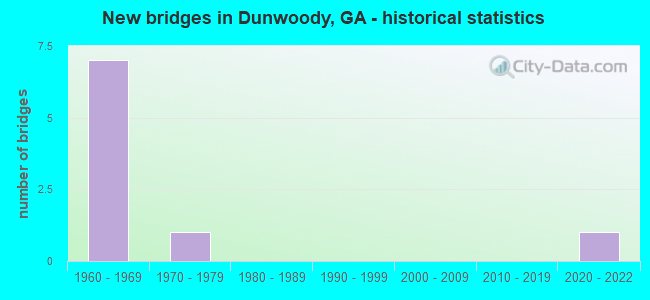
- New bridges - historical statistics
- 71960-1969
- 11970-1979
- 12020-2022

- Reconstructed bridges - Historical Statistics
- 31970-1979
- 21980-1989
- 11990-1999


- Bridge Condition - Deck
- 20.0%Very good
- 40.0%Good
- 40.0%Satisfactory

- Bridge Condition - Superstructure
- 20.0%Very good
- 40.0%Good
- 40.0%Satisfactory

- Bridge Condition - Channel
- 25.0%Very good
- 50.0%Good
- 25.0%Satisfactory
Find on map >> Show street view
Structure Number: 890071, Location: 2.5 MI NW OF CHAMBLEE (Lat: 33.920158, Lng: -84.327278), Route carried "on" structure: Interstate 285, Year Built: 1960, Year Reconstructed: 1975, Status: Open, Structure Length: 0.64m (2.10ft), Average Daily Traffic: 241,810 (year 2011), Truck Traffic: 1%, Average Future Daily Traffic: 362,715 (year 2031), Design Load: HS 20+Mod, Features Intersected: N FORK NANCY CREEK
Minimum Vertical Clearance: 30+ m (98+ ft), Kilometerpoint: 45.062, Lanes on structure: 12, Base Highway Network: Yes, Owner: State Highway Agency, Approaching Roadway Width: 55.8m (183.1ft), Skew: 30 degrees, Material/Design: Concrete, Design/Construction: Culvert, Number Of Spans In Main Unit: 2, Length of Maximum Span: 3.0m (9.8ft)
Condition: Channel: Very good, Culverts: Good, Structural Evaluation: Better than present minimum criteria, Waterway Adequacy: Equal to present desirable criteria, Approach Roadway Alignment: Equal to present desirable criteria, Designated Inspection Frequency: Every 24 months, Inspection Date: August 2020, Bridge Improvement Cost: $306,000, Roadway Improvement Cost: $31,000, Total Project Cost: $459,000
Find on map >> Show street view
Structure Number: 890072, Location: 1.9 MI N OF CHAMBLEE (Lat: 33.920306, Lng: -84.305178), Route carried "on" structure: Interstate 285, Year Built: 1961, Year Reconstructed: 1995, Status: Open, Structure Length: 3.57m (11.71ft), Average Daily Traffic: 210,740 (year 2011), Truck Traffic: 8%, Average Future Daily Traffic: 316,110 (year 2031), Design Load: HS 20+Mod, Features Intersected: M-9261 SHALLOWFORD ROAD
Minimum Vertical Clearance: 30+ m (98+ ft), Kilometerpoint: 46.671, Lanes on structure: 10, Lanes under structure: 4, Base Highway Network: Yes, Owner: State Highway Agency, Approaching Roadway Width: 46.9m (153.9ft), Skew: 33 degrees, Material/Design: Concrete continuous, Design/Construction: Slab, Number Of Spans In Main Unit: 3, Length of Maximum Span: 15.5m (50.9ft), Curb-To-Curb Width: 47.2m (154.9ft), Out-to-Out Width: 49.4m (162.1ft)
Condition: Deck: Satisfactory, Superstructure: Satisfactory, Substructure: Good, Operating Rating: 51.7 metric tons, Method Used To Determine Operating Rating: Load Factor (LF), Inventory Rating: 30.8 metric tons, Method Used To Determine Inventory Rating: Load Factor (LF), Structural Evaluation: Equal to present minimum criteria, Deck Geometry: Superior to present desirable criteria, Underclear: High priority of corrective action, Approach Roadway Alignment: Equal to present desirable criteria, Designated Inspection Frequency: Every 24 months, Inspection Date: August 2020, Bridge Improvement Cost: $1,455,000, Roadway Improvement Cost: $145,000, Total Project Cost: $2,182,000, Deck Structure Type: Concrete Cast-file-Place, Wearing Surface/Protective System: Wearing Surface: Epoxy Overlay
Find on map >> Show street view
Structure Number: 890073, Location: 1.9 MI NE OF CHAMBLEE (Lat: 33.920072, Lng: -84.296881), Route carried "on" structure: Interstate 285, Year Built: 1961, Year Reconstructed: 1993, Status: Open, Structure Length: 3.63m (11.91ft), Average Daily Traffic: 173,399 (year 2011), Truck Traffic: 1%, Average Future Daily Traffic: 260,099 (year 2031), Design Load: HS 20+Mod, Features Intersected: M-9262 N. PEACHTREE ROAD
Minimum Vertical Clearance: 30+ m (98+ ft), Kilometerpoint: 48.280, Lanes on structure: 10, Lanes under structure: 4, Base Highway Network: Yes, Owner: State Highway Agency, Approaching Roadway Width: 46.9m (153.9ft), Skew: 30 degrees, Material/Design: Concrete continuous, Design/Construction: Slab, Number Of Spans In Main Unit: 3, Length of Maximum Span: 14.9m (48.9ft), Curb-To-Curb Width: 47.2m (154.9ft), Out-to-Out Width: 49.4m (162.1ft)
Condition: Deck: Satisfactory, Superstructure: Satisfactory, Substructure: Good, Operating Rating: 82.5 metric tons, Method Used To Determine Operating Rating: Load Factor (LF), Inventory Rating: 48.9 metric tons, Method Used To Determine Inventory Rating: Load Factor (LF), Structural Evaluation: Equal to present minimum criteria, Deck Geometry: Superior to present desirable criteria, Underclear: High priority of corrective action, Approach Roadway Alignment: Equal to present desirable criteria, Designated Inspection Frequency: Every 24 months, Inspection Date: August 2020, Bridge Improvement Cost: $1,479,000, Roadway Improvement Cost: $148,000, Total Project Cost: $2,219,000, Deck Structure Type: Concrete Cast-file-Place
Find on map >> Show street view
Structure Number: 890074, Location: 2 MI N OF CHAMBLEE (Lat: 33.919350, Lng: -84.294639), Route carried "on" structure: Interstate 285, Year Built: 1961, Year Reconstructed: 1975, Status: Open, Structure Length: 1.19m (3.90ft), Average Daily Traffic: 239,000 (year 2011), Truck Traffic: 1%, Average Future Daily Traffic: 358,500 (year 2031), Design Load: HS 20+Mod, Features Intersected: NANCY CREEK
Minimum Vertical Clearance: 30+ m (98+ ft), Kilometerpoint: 48.280, Lanes on structure: 12, Base Highway Network: Yes, Owner: State Highway Agency, Approaching Roadway Width: 53.0m (173.9ft), Skew: 30 degrees, Material/Design: Concrete, Design/Construction: Culvert, Number Of Spans In Main Unit: 3, Length of Maximum Span: 3.0m (9.8ft)
Condition: Channel: Good, Culverts: Good, Structural Evaluation: Better than present minimum criteria, Waterway Adequacy: Superior to present desirable criteria, Approach Roadway Alignment: Equal to present desirable criteria, Designated Inspection Frequency: Every 24 months, Inspection Date: August 2020, Bridge Improvement Cost: $568,000, Roadway Improvement Cost: $57,000, Total Project Cost: $852,000
Find on map >> Show street view
Structure Number: 890141, Location: 2.8 MI NW OF CHAMBLEE (Lat: 33.918028, Lng: -84.338239), Route carried "on" structure: City street 9014, Year Built: 1961, Year Reconstructed: 1982, Status: Open, Structure Length: 7.44m (24.41ft), Average Daily Traffic: 52,290 (year 2011), Truck Traffic: 1%, Average Future Daily Traffic: 78,435 (year 2031), Design Load: HS 20+Mod, Features Intersected: I-285- I-285 RAMP, Facility Carried by Structure: ASHFORD-DUNWOODY R
Minimum Vertical Clearance: 30+ m (98+ ft), Kilometerpoint: 8.047, Lanes on structure: 6, Lanes under structure: 11, Base Highway Network: Yes, Owner: State Highway Agency, Approaching Roadway Width: 26.8m (87.9ft), Material/Design: Steel continuous, Design/Construction: Stringer/Multi-beam, Number Of Spans In Main Unit: 4, Length of Maximum Span: 21.3m (69.9ft), Curb or Sidewalk Widths: Left: 1.9m (6.2ft), Right: 1.9m (6.2ft), Curb-To-Curb Width: 26.8m (87.9ft), Out-to-Out Width: 31.2m (102.4ft)
Condition: Deck: Good, Superstructure: Good, Substructure: Good, Operating Rating: 45.3 metric tons, Method Used To Determine Operating Rating: Allowable Stress (AS), Inventory Rating: 32.6 metric tons, Method Used To Determine Inventory Rating: Allowable Stress (AS), Structural Evaluation: Better than present minimum criteria, Deck Geometry: Better than present minimum criteria, Underclear: High priority of corrective action, Approach Roadway Alignment: Equal to present desirable criteria, Designated Inspection Frequency: Every 24 months, Inspection Date: August 2020, Bridge Improvement Cost: $1,993,000, Roadway Improvement Cost: $199,000, Total Project Cost: $2,990,000, Deck Structure Type: Concrete Cast-file-Place, Wearing Surface/Protective System: Wearing Surface: Bituminous
Find on map >> Show street view
Structure Number: 890194, Location: 2 MI NW OF CHAMBLEE (Lat: 33.920269, Lng: -84.314800), Route carried "on" structure: City street 9260, Year Built: 1961, Year Reconstructed: 1980, Status: Open, Structure Length: 8.32m (27.30ft), Average Daily Traffic: 12,180 (year 2011), Truck Traffic: 1%, Average Future Daily Traffic: 18,270 (year 2031), Design Load: HS 20+Mod, Features Intersected: I-285 (SR 407), Facility Carried by Structure: CHAM. DUNWOODY RD.
Minimum Vertical Clearance: 30+ m (98+ ft), Kilometerpoint: 8.047, Lanes on structure: 5, Lanes under structure: 10, Base Highway Network: Yes, Owner: State Highway Agency, Approaching Roadway Width: 19.5m (64.0ft), Skew: 2 degrees, Material/Design: Steel continuous, Design/Construction: Stringer/Multi-beam, Number Of Spans In Main Unit: 4, Length of Maximum Span: 22.9m (75.1ft), Curb or Sidewalk Widths: Left: 1.4m (4.6ft), Right: 1.4m (4.6ft), Curb-To-Curb Width: 19.5m (64.0ft), Out-to-Out Width: 23.0m (75.5ft)
Condition: Deck: Good, Superstructure: Good, Substructure: Good, Operating Rating: 43.5 metric tons, Method Used To Determine Operating Rating: Load Factor (LF), Inventory Rating: 26.3 metric tons, Method Used To Determine Inventory Rating: Load Factor (LF), Structural Evaluation: Equal to present minimum criteria, Deck Geometry: Meets minimum limits, Underclear: High priority of corrective action, Approach Roadway Alignment: Equal to present desirable criteria, Designated Inspection Frequency: Every 24 months, Inspection Date: August 2020, Bridge Improvement Cost: $1,939,000, Roadway Improvement Cost: $194,000, Total Project Cost: $2,909,000, Deck Structure Type: Concrete Cast-file-Place, Wearing Surface/Protective System: Wearing Surface: Bituminous
Find on map >> Show street view
Structure Number: 890252, Location: 1.8 MI NW OF DORAVILLE (Lat: 33.920178, Lng: -84.302419), Route carried "on" structure: Interstate 285, Year Built: 1961, Status: Open, Structure Length: 0.98m (3.22ft), Average Daily Traffic: 210,740 (year 2011), Truck Traffic: 8%, Average Future Daily Traffic: 316,110 (year 2031), Design Load: HS 20+Mod, Features Intersected: NANCY CREEK TRIB
Minimum Vertical Clearance: 30+ m (98+ ft), Kilometerpoint: 46.671, Lanes on structure: 10, Base Highway Network: Yes, Owner: State Highway Agency, Approaching Roadway Width: 46.9m (153.9ft), Skew: 30 degrees, Material/Design: Concrete, Design/Construction: Culvert, Number Of Spans In Main Unit: 3, Length of Maximum Span: 2.7m (8.9ft)
Condition: Channel: Satisfactory, Culverts: Good, Structural Evaluation: Better than present minimum criteria, Waterway Adequacy: Equal to present desirable criteria, Approach Roadway Alignment: Equal to present desirable criteria, Designated Inspection Frequency: Every 24 months, Inspection Date: August 2020, Bridge Improvement Cost: $398,000, Roadway Improvement Cost: $40,000, Total Project Cost: $597,000
Find on map >> Show street view
Structure Number: 895096, Location: 2.4 MI N OF CHAMBLEE (Lat: 33.923297, Lng: -84.304019), Route carried "on" structure: County highway 5138, Year Built: 1976, Status: Open, Structure Length: 0.88m (2.89ft), Average Daily Traffic: 2,202 (year 2011), Truck Traffic: 1%, Average Future Daily Traffic: 3,303 (year 2031), Design Load: HS 20, Features Intersected: NANCY CREEK TRIB, Facility Carried by Structure: PEACHFORD ROAD
Minimum Vertical Clearance: 30+ m (98+ ft), Kilometerpoint: 0.000, Lanes on structure: 2, Base Highway Network: Yes, Owner: County Highway Agency, Approaching Roadway Width: 9.1m (29.9ft), Material/Design: Concrete, Design/Construction: Culvert, Number Of Spans In Main Unit: 3, Length of Maximum Span: 2.7m (8.9ft), Curb or Sidewalk Widths: Left: 1.2m (3.9ft), Right: 0.0m
Condition: Channel: Good, Culverts: Good, Operating Rating: 55.3 metric tons, Method Used To Determine Operating Rating: Field evaluation and documented engineering judgment, Inventory Rating: 32.6 metric tons, Method Used To Determine Inventory Rating: Field evaluation and documented engineering judgment, Structural Evaluation: Better than present minimum criteria, Waterway Adequacy: Better than present minimum criteria, Approach Roadway Alignment: Equal to present desirable criteria, Designated Inspection Frequency: Every 24 months, Inspection Date: August 2020, Bridge Improvement Cost: $113,000, Roadway Improvement Cost: $11,000, Total Project Cost: $170,000
Find on map >> Show street view
Structure Number: 895176, Location: 2.4 MI E OF CHAMBLEE (Lat: 33.918467, Lng: -84.339231), Route carried "on" structure: Ramp Interstate 407, Year Built: 2020, Status: Open, Structure Length: 12.03m (39.47ft), Average Daily Traffic: 23,340 (year 2019), Truck Traffic: 9%, Average Future Daily Traffic: 29,050 (year 2039), Design Load: HL 93, Features Intersected: I-285 Ramp, Facility Carried by Structure: RMP ASH-DUN TO 285
Minimum Vertical Clearance: 30+ m (98+ ft), Kilometerpoint: 43.452, Lanes on structure: 2, Lanes under structure: 3, Base Highway Network: Yes, Owner: State Highway Agency, Approaching Roadway Width: 13.5m (44.3ft), Material/Design: Prestressed concrete, Design/Construction: Stringer/Multi-beam, Number Of Spans In Main Unit: 3, Length of Maximum Span: 39.9m (130.9ft), Curb-To-Curb Width: 13.5m (44.3ft), Out-to-Out Width: 14.5m (47.6ft)
Condition: Deck: Very good, Superstructure: Very good, Substructure: Good, Operating Rating: 83.4 metric tons, Method Used To Determine Operating Rating: Load Factor (LF), Inventory Rating: 29.9 metric tons, Method Used To Determine Inventory Rating: Load Factor (LF), Structural Evaluation: Better than present minimum criteria, Deck Geometry: Superior to present desirable criteria, Underclear: Equal to present minimum criteria, Approach Roadway Alignment: Equal to present desirable criteria, Length Of Structure Improvement: 13.72m (45.01ft), Designated Inspection Frequency: Every 24 months, Inspection Date: November 2020, Bridge Improvement Cost: $33,300,000, Roadway Improvement Cost: $3,330,000, Total Project Cost: $49,950,000 ( Estimate for 2020), Deck Structure Type: Concrete Cast-file-Place
Find on map >> Show street view
Structure Number: 890072, Location: 1.9 MI N OF CHAMBLEE (Lat: 33.920306, Lng: -84.305178), Route carried "under" structure: City street 9261, Structure Length: 0. m, Average Daily Traffic: 20,156 (year 1999), Truck Traffic: 1%, Features Intersected: I-285 (SR 407), Facility Carried by Structure: I-285
Minimum Vertical Clearance: 4.44m (14.57ft), Kilometerpoint: 1.609, Lanes on structure: 10, Length of Maximum Span: 0.0m
Find on map >> Show street view
Structure Number: 890073, Location: 1.9 MI NE OF CHAMBLEE (Lat: 33.920072, Lng: -84.296881), Route carried "under" structure: City street 9262, Structure Length: 0. m, Average Daily Traffic: 17,300 (year 1999), Truck Traffic: 1%, Features Intersected: I-285 (SR 407), Facility Carried by Structure: I-285
Minimum Vertical Clearance: 5.02m (16.47ft), Kilometerpoint: 4.828, Lanes on structure: 10, Length of Maximum Span: 0.0m
Find on map >> Show street view
Structure Number: 890141, Location: 2.8 MI NW OF CHAMBLEE (Lat: 33.918028, Lng: -84.338239), Route carried "under" structure: Interstate 2851, Structure Length: 0. m, Average Daily Traffic: 261,100 (year 1999), Truck Traffic: 1%, Features Intersected: M-9014 ASHFORD-DUNWOODY, Facility Carried by Structure: ASHFORD-DUNWOODY R
Minimum Vertical Clearance: 5.48m (17.98ft), Kilometerpoint: 43.452, Lanes on structure: 6, Length of Maximum Span: 0.0m
Find on map >> Show street view
Structure Number: 890194, Location: 2 MI NW OF CHAMBLEE (Lat: 33.920269, Lng: -84.314800), Route carried "under" structure: Interstate 285, Structure Length: 0. m, Average Daily Traffic: 238,800 (year 1999), Truck Traffic: 1%, Features Intersected: M-9260 CHAM DUNWOODY RD, Facility Carried by Structure: CHAM. DUNWOODY RD.
Minimum Vertical Clearance: 6.55m (21.49ft), Kilometerpoint: 46.671, Lanes on structure: 5, Length of Maximum Span: 0.0m
Find on map >> Show street view
Structure Number: 895142, Location: 2.8 MI NW OF CHAMBLEE (Lat: 33.916436, Lng: -84.343583), Route carried "under" structure: Interstate 285, Structure Length: 0. m, Average Daily Traffic: 243,560 (year 2020), Truck Traffic: 15%, Features Intersected: 0, Facility Carried by Structure: MARTA
Minimum Vertical Clearance: 8.66m (28.41ft), Kilometerpoint: 43.694, Lanes on structure: 12, Length of Maximum Span: 0.0m
Find on map >> Show street view
Structure Number: 895176, Location: 2.4 MI E OF CHAMBLEE (Lat: 33.918467, Lng: -84.339231), Route carried "under" structure: Ramp Interstate 407, Structure Length: 0. m, Average Daily Traffic: 23,340 (year 2019), Truck Traffic: 9%, Features Intersected: RAMP FROM 285, Facility Carried by Structure: RMP ASH-DUN TO 285
Minimum Vertical Clearance: 5.48m (17.98ft), Kilometerpoint: 43.452, Lanes on structure: 2, Length of Maximum Span: 0.0m