Bridge Statistics for DuPont, Washington (WA)
Condition, Traffic, Stress, Structural Evaluation, Project Costs
- National Bridge Inventory (NBI) Statistics
- 19Number of bridges
- 361ft / 110mTotal length
- $74,616,000Total costs
- 915,043Total average daily traffic
- 97,254Total average daily truck traffic
- National Bridge Inventory (NBI) Registered Bridges for DuPont
- No street view available for this location
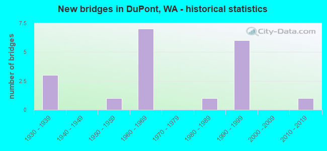
- New bridges - historical statistics
- 31930-1939
- 11950-1959
- 71960-1969
- 11980-1989
- 61990-1999
- 12010-2019

- Reconstructed bridges - Historical Statistics
- 11960-1969
- 11970-1979


- Bridge Condition - Deck
- 63.6%Good
- 36.4%Satisfactory

- Bridge Condition - Superstructure
- 9.1%Very good
- 54.5%Good
- 27.3%Satisfactory
- 9.1%Fair

- Bridge Condition - Substructure
- 90.9%Good
- 9.1%Satisfactory

- Bridge Condition - Channel
- 50.0%Very good
- 50.0%Satisfactory
Find on map >> Show street view
Structure Number: 2069A, Location: 2.9 N JCT SR 510 (Lat: 47.071286, Lng: -122.704864), Route carried "on" structure: Interstate 5, Year Built: 1937, Year Reconstructed: 1982, Status: Open, Structure Length: 13.62m (44.69ft), Average Daily Traffic: 62,281 (year 2019), Truck Traffic: 11%, Average Future Daily Traffic: 90,182 (year 2039), Design Load: H 15, Features Intersected: NISQUALLY RIVER
Minimum Vertical Clearance: 5.13m (16.83ft), Kilometerpoint: 184.881, Lanes on structure: 3, Base Highway Network: Yes, Owner: State Highway Agency, Approaching Roadway Width: 15.8m (51.8ft), Navigation Control: Yes ( Vertical Clearance: 3.4m (11.2ft), Horizontal Clearance: 96.3m (315.9ft)), Material/Design: Steel, Design/Construction: Truss - Thru, Number Of Spans In Main Unit: 1, Number Of Approach Spans: 2, Length of Maximum Span: 98.5m (323.2ft), Curb-To-Curb Width: 13.0m (42.7ft), Out-to-Out Width: 14.0m (45.9ft)
Condition: Deck: Satisfactory, Superstructure: Fair, Substructure: Good, Channel: Satisfactory, Operating Rating: 55.3 metric tons, Method Used To Determine Operating Rating: Load Factor (LF), Inventory Rating: 33.6 metric tons, Method Used To Determine Inventory Rating: Load Factor (LF), Structural Evaluation: Somewhat better than minimum adequacy, Deck Geometry: Meets minimum limits, Waterway Adequacy: Equal to present desirable criteria, Approach Roadway Alignment: Equal to present desirable criteria, Length Of Structure Improvement: 13.62m (44.69ft), Designated Inspection Frequency: Every 24 months, Critical Feature Inspection Frequency: Every 24 months, Inspection Date: April 2021, Critical Feature Inspection Date: April 2021, Bridge Improvement Cost: $4,828,000, Roadway Improvement Cost: $966,000, Total Project Cost: $9,655,000 ( Estimate for 2014), Deck Structure Type: Concrete Cast-file-Place, Wearing Surface/Protective System: Wearing Surface: Low Slump Concrete
Find on map >> Show street view
Structure Number: 5284A, Location: 3.7 N THURSTON CO (Lat: 47.089678, Lng: -122.637067), Route carried "on" structure: Interstate 5, Year Built: 1957, Year Reconstructed: 1969, Status: Open, Structure Length: 5.94m (19.49ft), Average Daily Traffic: 125,988 (year 2019), Truck Traffic: 11%, Average Future Daily Traffic: 182,430 (year 2039), Design Load: HS 20, Features Intersected: RAILROAD - LAUNDRY SPUR
Minimum Vertical Clearance: 30+ m (98+ ft), Kilometerpoint: 190.434, Lanes on structure: 10, Base Highway Network: Yes, Owner: State Highway Agency, Approaching Roadway Width: 44.8m (147.0ft), Skew: 34 degrees, Material/Design: Concrete continuous, Design/Construction: Box Beam or Girders - Multiple, Number Of Spans In Main Unit: 3, Length of Maximum Span: 22.9m (75.1ft), Curb-To-Curb Width: 44.8m (147.0ft), Out-to-Out Width: 46.6m (152.9ft)
Condition: Deck: Satisfactory, Superstructure: Good, Substructure: Good, Operating Rating: 21.7 metric tons, Method Used To Determine Operating Rating: Load and Resistance Factor Rating (LRFR) rating reported by rating factor(RF) method using HL-93 loadings, Inventory Rating: 16.5 metric tons, Method Used To Determine Inventory Rating: Load and Resistance Factor Rating (LRFR) rating reported by rating factor(RF) method using HL-93 loadings, Structural Evaluation: Meets minimum limits, Deck Geometry: Superior to present desirable criteria, Underclear: Better than present minimum criteria, Approach Roadway Alignment: Equal to present desirable criteria, Length Of Structure Improvement: 5.94m (19.49ft), Designated Inspection Frequency: Every 24 months, Inspection Date: March 2020, Bridge Improvement Cost: $5,811,000, Roadway Improvement Cost: $1,162,000, Total Project Cost: $11,622,000 ( Estimate for 2014), Deck Structure Type: Concrete Cast-file-Place, Wearing Surface/Protective System: Wearing Surface: Latex Concrete
Find on map >> Show street view
Structure Number: 6274A, Location: 2.0 N THURSTON CO (Lat: 47.083194, Lng: -122.670250), Route carried "on" structure: County highway 5, Year Built: 1960, Status: Open, Structure Length: 0.94m (3.08ft), Average Daily Traffic: 9,550 (year 2002), Truck Traffic: 1%, Average Future Daily Traffic: 13,122 (year 2036), Design Load: HS 20, Features Intersected: BNRR
Minimum Vertical Clearance: 30+ m (98+ ft), Kilometerpoint: 3.476, Lanes on structure: 2, Owner: State Highway Agency, Approaching Roadway Width: 7.9m (25.9ft), Material/Design: Concrete, Design/Construction: Slab, Number Of Spans In Main Unit: 1, Length of Maximum Span: 8.8m (28.9ft), Curb or Sidewalk Widths: Left: 0.9m (3.0ft), Right: 0.3m (1.0ft), Curb-To-Curb Width: 7.9m (25.9ft), Out-to-Out Width: 10.4m (34.1ft)
Condition: Deck: Good, Superstructure: Good, Substructure: Good, Operating Rating: 70.7 metric tons, Method Used To Determine Operating Rating: Load Factor (LF), Inventory Rating: 41.7 metric tons, Method Used To Determine Inventory Rating: Load Factor (LF), Structural Evaluation: Better than present minimum criteria, Deck Geometry: High priority of replacement, Underclear: Meets minimum limits, Approach Roadway Alignment: Equal to present desirable criteria, Length Of Structure Improvement: 0.94m (3.08ft), Designated Inspection Frequency: Every 48 months, Inspection Date: July 2021, Bridge Improvement Cost: $174,000, Roadway Improvement Cost: $35,000, Total Project Cost: $347,000 ( Estimate for 2014), Deck Structure Type: Concrete Cast-file-Place, Wearing Surface/Protective System: Wearing Surface: Monolithic Concrete
Find on map >> Show street view
Structure Number: 8116A, Location: 2.9 N JCT SR 510 (Lat: 47.071542, Lng: -122.704944), Route carried "on" structure: Interstate 5, Year Built: 1967, Status: Open, Structure Length: 13.14m (43.11ft), Average Daily Traffic: 62,281 (year 2019), Truck Traffic: 11%, Average Future Daily Traffic: 90,182 (year 2039), Design Load: HS 20+Mod, Features Intersected: NISQUALLY RIVER
Minimum Vertical Clearance: 5.61m (18.41ft), Kilometerpoint: 184.881, Lanes on structure: 3, Base Highway Network: Yes, Owner: State Highway Agency, Approaching Roadway Width: 17.1m (56.1ft), Material/Design: Steel, Design/Construction: Truss - Thru, Number Of Spans In Main Unit: 1, Number Of Approach Spans: 2, Length of Maximum Span: 98.1m (321.9ft), Curb or Sidewalk Widths: Left: 0.2m (0.7ft), Right: 0.2m (0.7ft), Curb-To-Curb Width: 14.6m (47.9ft), Out-to-Out Width: 16.0m (52.5ft)
Condition: Deck: Satisfactory, Superstructure: Satisfactory, Substructure: Satisfactory, Channel: Satisfactory, Operating Rating: 49.9 metric tons, Method Used To Determine Operating Rating: Load Factor (LF), Inventory Rating: 29.9 metric tons, Method Used To Determine Inventory Rating: Load Factor (LF), Structural Evaluation: Equal to present minimum criteria, Deck Geometry: Meets minimum limits, Waterway Adequacy: Equal to present desirable criteria, Approach Roadway Alignment: Equal to present desirable criteria, Length Of Structure Improvement: 13.14m (43.11ft), Designated Inspection Frequency: Every 24 months, Critical Feature Inspection Frequency: Every 24 months, Inspection Date: April 2021, Critical Feature Inspection Date: April 2021, Bridge Improvement Cost: $5,000,000, Roadway Improvement Cost: $1,000,000, Total Project Cost: $9,999,000 ( Estimate for 2014), Deck Structure Type: Concrete Cast-file-Place, Wearing Surface/Protective System: Wearing Surface: Monolithic Concrete
Find on map >> Show street view
Structure Number: 8134A, Location: 0.6 N THURSTON CO (Lat: 47.075639, Lng: -122.696556), Route carried "on" structure: Interstate 5, Year Built: 1968, Status: Open, Structure Length: 12.19m (39.99ft), Average Daily Traffic: 62,281 (year 2019), Truck Traffic: 11%, Average Future Daily Traffic: 90,182 (year 2039), Design Load: HS 20+Mod, Features Intersected: NISQUALLY OVERFLOW
Minimum Vertical Clearance: 30+ m (98+ ft), Kilometerpoint: 185.670, Lanes on structure: 3, Base Highway Network: Yes, Owner: State Highway Agency, Approaching Roadway Width: 15.2m (49.9ft), Material/Design: Prestressed concrete, Design/Construction: Stringer/Multi-beam, Number Of Spans In Main Unit: 4, Length of Maximum Span: 30.5m (100.1ft), Curb or Sidewalk Widths: Left: 0.2m (0.7ft), Right: 0.2m (0.7ft), Curb-To-Curb Width: 14.6m (47.9ft), Out-to-Out Width: 15.7m (51.5ft)
Condition: Deck: Good, Superstructure: Satisfactory, Substructure: Good, Channel: Very good, Operating Rating: 81.6 metric tons, Method Used To Determine Operating Rating: Load Factor (LF), Inventory Rating: 49.0 metric tons, Method Used To Determine Inventory Rating: Load Factor (LF), Structural Evaluation: Equal to present minimum criteria, Deck Geometry: Meets minimum limits, Waterway Adequacy: Equal to present desirable criteria, Approach Roadway Alignment: Equal to present desirable criteria, Length Of Structure Improvement: 12.19m (39.99ft), Designated Inspection Frequency: Every 48 months, Inspection Date: September 2018, Bridge Improvement Cost: $4,160,000, Roadway Improvement Cost: $832,000, Total Project Cost: $8,320,000 ( Estimate for 2014), Deck Structure Type: Concrete Cast-file-Place, Wearing Surface/Protective System: Wearing Surface: Latex Concrete
Find on map >> Show street view
Structure Number: 8134D, Location: 2.0 N THURSTON CO (Lat: 47.082806, Lng: -122.670139), Route carried "on" structure: County highway , Year Built: 1967, Status: Open, Structure Length: 4.21m (13.81ft), Average Daily Traffic: 5,686 (year 2016), Truck Traffic: 2%, Average Future Daily Traffic: 9,256 (year 2038), Design Load: HS 20+Mod, Features Intersected: I-5, Facility Carried by Structure: OLD NISQUALLY RD
Minimum Vertical Clearance: 30+ m (98+ ft), Kilometerpoint: 0.016, Lanes on structure: 2, Lanes under structure: 6, Owner: State Highway Agency, Approaching Roadway Width: 11.6m (38.1ft), Material/Design: Prestressed concrete, Design/Construction: Stringer/Multi-beam, Number Of Spans In Main Unit: 2, Length of Maximum Span: 21.0m (68.9ft), Curb or Sidewalk Widths: Left: 0.2m (0.7ft), Right: 0.2m (0.7ft), Curb-To-Curb Width: 11.1m (36.4ft), Out-to-Out Width: 12.2m (40.0ft)
Condition: Deck: Good, Superstructure: Good, Substructure: Good, Operating Rating: 66.2 metric tons, Method Used To Determine Operating Rating: Load Factor (LF), Inventory Rating: 33.6 metric tons, Method Used To Determine Inventory Rating: Load Factor (LF), Structural Evaluation: Better than present minimum criteria, Deck Geometry: Meets minimum limits, Underclear: Equal to present minimum criteria, Approach Roadway Alignment: Equal to present desirable criteria, Length Of Structure Improvement: 4.21m (13.81ft), Designated Inspection Frequency: Every 24 months, Inspection Date: March 2020, Bridge Improvement Cost: $1,104,000, Roadway Improvement Cost: $221,000, Total Project Cost: $2,208,000 ( Estimate for 2014), Deck Structure Type: Concrete Cast-file-Place, Wearing Surface/Protective System: Wearing Surface: Bituminous, Membrane: Preformed Fabric
Find on map >> Show street view
Structure Number: 12137B, Location: 0.6 N THURSTON CO (Lat: 47.075111, Lng: -122.694972), Route carried "on" structure: Interstate 5, Year Built: 1983, Status: Open, Structure Length: 12.19m (39.99ft), Average Daily Traffic: 62,281 (year 2019), Truck Traffic: 11%, Average Future Daily Traffic: 90,182 (year 2039), Design Load: HS 20+Mod, Features Intersected: NISQUALLY OVERFLOW
Minimum Vertical Clearance: 30+ m (98+ ft), Kilometerpoint: 185.750, Lanes on structure: 3, Base Highway Network: Yes, Owner: State Highway Agency, Approaching Roadway Width: 15.8m (51.8ft), Material/Design: Prestressed concrete continuous, Design/Construction: Stringer/Multi-beam, Number Of Spans In Main Unit: 4, Length of Maximum Span: 30.5m (100.1ft), Curb-To-Curb Width: 15.8m (51.8ft), Out-to-Out Width: 16.8m (55.1ft)
Condition: Deck: Satisfactory, Superstructure: Good, Substructure: Good, Channel: Very good, Operating Rating: 41.1 metric tons, Method Used To Determine Operating Rating: Load and Resistance Factor Rating (LRFR) rating reported by rating factor(RF) method using HL-93 loadings, Inventory Rating: 31.8 metric tons, Method Used To Determine Inventory Rating: Load and Resistance Factor Rating (LRFR) rating reported by rating factor(RF) method using HL-93 loadings, Structural Evaluation: Better than present minimum criteria, Deck Geometry: Somewhat better than minimum adequacy, Waterway Adequacy: Equal to present desirable criteria, Approach Roadway Alignment: Equal to present desirable criteria, Length Of Structure Improvement: 12.19m (39.99ft), Designated Inspection Frequency: Every 48 months, Inspection Date: September 2018, Bridge Improvement Cost: $4,320,000, Roadway Improvement Cost: $864,000, Total Project Cost: $8,640,000 ( Estimate for 2014), Deck Structure Type: Concrete Cast-file-Place, Wearing Surface/Protective System: Wearing Surface: Monolithic Concrete, Deck Protection: Epoxy Coated Reinforcing
Find on map >> Show street view
Structure Number: 14963A, Location: 2.5 N THURSTON CO (Lat: 47.087647, Lng: -122.644583), Route carried "on" structure: County highway 5, Year Built: 1997, Status: Open, Structure Length: 11.09m (36.38ft), Average Daily Traffic: 16,910 (year 2013), Truck Traffic: 2%, Average Future Daily Traffic: 30,386 (year 2035), Design Load: HS 25 or greater, Features Intersected: I-5, Facility Carried by Structure: CENTER DRIVE
Minimum Vertical Clearance: 30+ m (98+ ft), Kilometerpoint: 0.113, Lanes on structure: 3, Lanes under structure: 9, Base Highway Network: Yes, Owner: State Highway Agency, Approaching Roadway Width: 20.4m (66.9ft), Material/Design: Prestressed concrete continuous, Design/Construction: Stringer/Multi-beam, Number Of Spans In Main Unit: 4, Length of Maximum Span: 30.8m (101.0ft), Curb-To-Curb Width: 20.4m (66.9ft), Out-to-Out Width: 21.4m (70.2ft)
Condition: Deck: Good, Superstructure: Good, Substructure: Good, Operating Rating: 60.8 metric tons, Method Used To Determine Operating Rating: Load Factor (LF), Inventory Rating: 36.3 metric tons, Method Used To Determine Inventory Rating: Load Factor (LF), Structural Evaluation: Better than present minimum criteria, Deck Geometry: Superior to present desirable criteria, Underclear: High priority of corrective action, Approach Roadway Alignment: Equal to present desirable criteria, Length Of Structure Improvement: 11.09m (36.38ft), Designated Inspection Frequency: Every 24 months, Inspection Date: March 2020, Bridge Improvement Cost: $5,023,000, Roadway Improvement Cost: $1,005,000, Total Project Cost: $10,046,000 ( Estimate for 2014), Deck Structure Type: Concrete Cast-file-Place, Wearing Surface/Protective System: Wearing Surface: Monolithic Concrete, Deck Protection: Epoxy Coated Reinforcing
Find on map >> Show street view
Structure Number: 14963B, Location: 3.1 N THURSTON CO (Lat: 47.087578, Lng: -122.647992), Route carried "on" structure: Ramp Interstate 5, Year Built: 1997, Status: Open, Structure Length: 18.11m (59.42ft), Average Daily Traffic: 4,429 (year 2019), Truck Traffic: 2%, Average Future Daily Traffic: 6,413 (year 2039), Design Load: HS 25 or greater, Features Intersected: BN RR, Facility Carried by Structure: S-S RAMP
Minimum Vertical Clearance: 30+ m (98+ ft), Kilometerpoint: 0.209, Lanes on structure: 1, Owner: State Highway Agency, Approaching Roadway Width: 8.2m (26.9ft), Material/Design: Prestressed concrete continuous, Design/Construction: Stringer/Multi-beam, Number Of Spans In Main Unit: 5, Length of Maximum Span: 37.5m (123.0ft), Curb-To-Curb Width: 8.1m (26.6ft), Out-to-Out Width: 8.6m (28.2ft)
Condition: Deck: Good, Superstructure: Satisfactory, Substructure: Good, Operating Rating: 23.3 metric tons, Method Used To Determine Operating Rating: Load and Resistance Factor Rating (LRFR) rating reported by rating factor(RF) method using HL-93 loadings, Inventory Rating: 17.8 metric tons, Method Used To Determine Inventory Rating: Load and Resistance Factor Rating (LRFR) rating reported by rating factor(RF) method using HL-93 loadings, Structural Evaluation: Meets minimum limits, Deck Geometry: Superior to present desirable criteria, Underclear: Equal to present minimum criteria, Approach Roadway Alignment: Equal to present desirable criteria, Length Of Structure Improvement: 18.11m (59.42ft), Designated Inspection Frequency: Every 24 months, Inspection Date: March 2021, Bridge Improvement Cost: $3,445,000, Roadway Improvement Cost: $689,000, Total Project Cost: $6,890,000 ( Estimate for 2014), Deck Structure Type: Concrete Cast-file-Place, Wearing Surface/Protective System: Wearing Surface: Monolithic Concrete, Deck Protection: Epoxy Coated Reinforcing
Find on map >> Show street view
Structure Number: 14963C, Location: 3.5 N THURSTON CO (Lat: 47.089194, Lng: -122.640639), Route carried "on" structure: Ramp Interstate 5, Year Built: 1997, Status: Open, Structure Length: 15.61m (51.21ft), Average Daily Traffic: 4,431 (year 2019), Truck Traffic: 3%, Average Future Daily Traffic: 6,416 (year 2039), Design Load: HS 25 or greater, Features Intersected: BN RR, Facility Carried by Structure: S-N RAMP
Minimum Vertical Clearance: 30+ m (98+ ft), Kilometerpoint: 0.354, Lanes on structure: 1, Owner: State Highway Agency, Approaching Roadway Width: 8.2m (26.9ft), Material/Design: Prestressed concrete continuous, Design/Construction: Stringer/Multi-beam, Number Of Spans In Main Unit: 4, Length of Maximum Span: 37.5m (123.0ft), Curb-To-Curb Width: 8.1m (26.6ft), Out-to-Out Width: 9.1m (29.9ft)
Condition: Deck: Good, Superstructure: Good, Substructure: Good, Operating Rating: 66.2 metric tons, Method Used To Determine Operating Rating: Load Factor (LF), Inventory Rating: 39.9 metric tons, Method Used To Determine Inventory Rating: Load Factor (LF), Structural Evaluation: Better than present minimum criteria, Deck Geometry: Superior to present desirable criteria, Underclear: Equal to present minimum criteria, Approach Roadway Alignment: Equal to present desirable criteria, Length Of Structure Improvement: 15.61m (51.21ft), Designated Inspection Frequency: Every 24 months, Inspection Date: March 2021, Bridge Improvement Cost: $2,970,000, Roadway Improvement Cost: $594,000, Total Project Cost: $5,939,000 ( Estimate for 2014), Deck Structure Type: Concrete Cast-file-Place, Wearing Surface/Protective System: Wearing Surface: Monolithic Concrete, Deck Protection: Epoxy Coated Reinforcing
Find on map >> Show street view
Structure Number: 14963D, Location: 3.3 N THURSTON CO (Lat: 47.085725, Lng: -122.643717), Route carried "on" structure: ServiceOther road 5, Year Built: 1997, Status: Open, Structure Length: 3.02m (9.91ft), Average Daily Traffic: 125 (year 2002), Truck Traffic: 5%, Average Future Daily Traffic: 172 (year 2036), Design Load: HS 25 or greater, Features Intersected: TRUCK RAMP, Facility Carried by Structure: CENTER DR-FT LEWIS
Minimum Vertical Clearance: 30+ m (98+ ft), Kilometerpoint: 0.032, Lanes on structure: 1, Lanes under structure: 1, Owner: State Highway Agency, Approaching Roadway Width: 6.7m (22.0ft), Material/Design: Prestressed concrete, Design/Construction: Stringer/Multi-beam, Number Of Spans In Main Unit: 1, Length of Maximum Span: 28.0m (91.9ft), Curb-To-Curb Width: 6.6m (21.7ft), Out-to-Out Width: 7.7m (25.3ft)
Condition: Deck: Good, Superstructure: Very good, Substructure: Good, Operating Rating: 85.3 metric tons, Method Used To Determine Operating Rating: Load Factor (LF), Inventory Rating: 50.8 metric tons, Method Used To Determine Inventory Rating: Load Factor (LF), Structural Evaluation: Better than present minimum criteria, Deck Geometry: Meets minimum limits, Underclear: Equal to present minimum criteria, Approach Roadway Alignment: Equal to present desirable criteria, Length Of Structure Improvement: 3.02m (9.91ft), Designated Inspection Frequency: Every 48 months, Inspection Date: March 2021, Bridge Improvement Cost: $475,000, Roadway Improvement Cost: $95,000, Total Project Cost: $950,000 ( Estimate for 2014), Deck Structure Type: Concrete Cast-file-Place, Wearing Surface/Protective System: Wearing Surface: Monolithic Concrete, Deck Protection: Epoxy Coated Reinforcing
Find on map >> Show street view
Structure Number: 2082A, Location: 1.7 N THURSTON CO (Lat: 47.082000, Lng: -122.675778), Route carried "under" structure: Interstate 5, Year Built: 1936, Structure Length: 0. m, Average Daily Traffic: 61,806 (year 2019), Truck Traffic: 11%, Features Intersected: I-5, Facility Carried by Structure: BNRR FT LEWIS SPUR
Minimum Vertical Clearance: 5.28m (17.32ft), Kilometerpoint: 187.376, Lanes under structure: 3, Material/Design: Steel, Design/Construction: Girder and Floorbeam System, Length of Maximum Span: 27.7m (90.9ft)
Find on map >> Show street view
Structure Number: 2108A, Location: 0.9 N THURSTON CO (Lat: 47.076667, Lng: -122.690917), Route carried "under" structure: Interstate 5, Year Built: 1936, Structure Length: 0. m, Average Daily Traffic: 62,281 (year 2019), Truck Traffic: 11%, Features Intersected: I-5, Facility Carried by Structure: BNRR PT DEFIANCE
Minimum Vertical Clearance: 7.01m (23.00ft), Kilometerpoint: 186.088, Lanes under structure: 3, Material/Design: Steel, Design/Construction: Girder and Floorbeam System, Length of Maximum Span: 10.4m (34.1ft)
Find on map >> Show street view
Structure Number: 8134B, Location: 0.9 N THURSTON CO (Lat: 47.078333, Lng: -122.690000), Route carried "under" structure: Interstate 5, Year Built: 1967, Structure Length: 0. m, Average Daily Traffic: 62,281 (year 2019), Truck Traffic: 11%, Features Intersected: I-5, Facility Carried by Structure: BNRR PT DEFIANCE
Minimum Vertical Clearance: 5.72m (18.77ft), Kilometerpoint: 186.169, Lanes under structure: 3, Material/Design: Steel, Design/Construction: Girder and Floorbeam System, Length of Maximum Span: 22.3m (73.2ft)
Find on map >> Show street view
Structure Number: 8134C, Location: 1.7 N THURSTON CO (Lat: 47.081083, Lng: -122.676611), Route carried "under" structure: Interstate 5, Year Built: 1967, Structure Length: 0. m, Average Daily Traffic: 62,281 (year 2019), Truck Traffic: 11%, Features Intersected: I-5, Facility Carried by Structure: BNRR FT LEWIS SPUR
Minimum Vertical Clearance: 5.23m (17.16ft), Kilometerpoint: 187.295, Lanes under structure: 3, Material/Design: Steel, Design/Construction: Girder and Floorbeam System, Length of Maximum Span: 11.0m (36.1ft)
Find on map >> Show street view
Structure Number: 8134D, Location: 2.0 N THURSTON CO (Lat: 47.082806, Lng: -122.670139), Route carried "under" structure: Interstate 5, Year Built: 1967, Structure Length: 0. m, Average Daily Traffic: 123,611 (year 2019), Truck Traffic: 11%, Features Intersected: I-5, Facility Carried by Structure: OLD NISQUALLY RD
Minimum Vertical Clearance: 6.35m (20.83ft), Kilometerpoint: 187.810, Lanes on structure: 2, Lanes under structure: 6, Material/Design: Prestressed concrete, Design/Construction: Stringer/Multi-beam, Length of Maximum Span: 21.0m (68.9ft)
Find on map >> Show street view
Structure Number: 14963A, Location: 2.5 N THURSTON CO (Lat: 47.087647, Lng: -122.644583), Route carried "under" structure: Interstate 5, Year Built: 1997, Structure Length: 0. m, Average Daily Traffic: 125,988 (year 2019), Truck Traffic: 11%, Features Intersected: I-5, Facility Carried by Structure: CENTER DRIVE
Minimum Vertical Clearance: 6.65m (21.82ft), Kilometerpoint: 189.838, Lanes on structure: 3, Lanes under structure: 8, Material/Design: Prestressed concrete continuous, Design/Construction: Stringer/Multi-beam, Length of Maximum Span: 30.8m (101.0ft)
Find on map >> Show street view
Structure Number: 14963D, Location: 2.8 N THURSTON CO (Lat: 47.085725, Lng: -122.643717), Route carried "under" structure: Ramp Interstate 5, Year Built: 1997, Structure Length: 0. m, Average Daily Traffic: 502 (year 2015), Truck Traffic: 84%, Features Intersected: TRUCK RAMP, Facility Carried by Structure: CENTER DR-FT LEWIS
Minimum Vertical Clearance: 5.61m (18.41ft), Kilometerpoint: 1.159, Lanes on structure: 1, Lanes under structure: 1, Material/Design: Prestressed concrete, Design/Construction: Stringer/Multi-beam, Length of Maximum Span: 28.0m (91.9ft)
Find on map >> Show street view
Structure Number: 8906, Location: 1.3 NORTH & WEST JCT. SR5 (Lat: 47.082900, Lng: -122.690336), Route carried "under" structure: ServiceCounty highway 10060, Year Built: 2018, Structure Length: 0. m, Average Daily Traffic: 50 (year 2021), Truck Traffic: 1%, Features Intersected: MOUNTS RD SW, Facility Carried by Structure: BNSF RAILROAD
Minimum Vertical Clearance: 4.93m (16.17ft), Kilometerpoint: 0.001, Lanes under structure: 1, Material/Design: Concrete, Design/Construction: Slab, Length of Maximum Span: 5.8m (19.0ft)