Bridge Statistics for Druid Hills, Georgia (GA)
Condition, Traffic, Stress, Structural Evaluation, Project Costs
- National Bridge Inventory (NBI) Statistics
- 14Number of bridges
- 56ft / 16.5mTotal length
- $4,281,000Total costs
- 189,624Total average daily traffic
- 2,055Total average daily truck traffic
- National Bridge Inventory (NBI) Registered Bridges for Druid Hills
- No street view available for this location
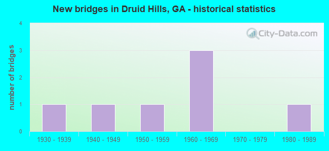
- New bridges - historical statistics
- 11930-1939
- 11940-1949
- 11950-1959
- 31960-1969
- 11980-1989


- Bridge Condition - Deck
- 20.0%Good
- 60.0%Satisfactory
- 20.0%Fair

- Bridge Condition - Superstructure
- 40.0%Good
- 40.0%Satisfactory
- 20.0%Poor

- Bridge Condition - Substructure
- 40.0%Good
- 60.0%Satisfactory

- Bridge Condition - Channel
- 50.0%Very good
- 33.3%Good
- 16.7%Satisfactory
Find on map >> Show street view
Structure Number: 890044, Location: 2.4 MI N OF DECATUR (Lat: 33.800739, Lng: -84.309039), Route carried "on" structure: US 23, Year Built: 1963, Status: Open, Structure Length: 3.47m (11.38ft), Average Daily Traffic: 32,170 (year 2011), Truck Traffic: 1%, Average Future Daily Traffic: 48,255 (year 2031), Design Load: HS 20+Mod, Features Intersected: S FORK PEACHTREE CREEK, Facility Carried by Structure: CLAIRMONT ROAD
Minimum Vertical Clearance: 30+ m (98+ ft), Kilometerpoint: 25.750, Lanes on structure: 5, Base Highway Network: Yes, Owner: State Highway Agency, Approaching Roadway Width: 21.9m (71.9ft), Material/Design: Concrete, Design/Construction: Tee Beam, Number Of Spans In Main Unit: 3, Length of Maximum Span: 11.6m (38.1ft), Curb or Sidewalk Widths: Left: 1.6m (5.2ft), Right: 1.4m (4.6ft), Curb-To-Curb Width: 20.7m (67.9ft), Out-to-Out Width: 24.4m (80.1ft)
Condition: Deck: Satisfactory, Superstructure: Good, Substructure: Satisfactory, Channel: Good, Operating Rating: 42.6 metric tons, Method Used To Determine Operating Rating: Load Factor (LF), Inventory Rating: 25.4 metric tons, Method Used To Determine Inventory Rating: Load Factor (LF), Structural Evaluation: Equal to present minimum criteria, Deck Geometry: Somewhat better than minimum adequacy, Waterway Adequacy: Equal to present minimum criteria, Approach Roadway Alignment: Equal to present desirable criteria, Designated Inspection Frequency: Every 24 months, Inspection Date: June 2020, Bridge Improvement Cost: $810,000, Roadway Improvement Cost: $81,000, Total Project Cost: $1,215,000, Deck Structure Type: Concrete Cast-file-Place
Find on map >> Show street view
Structure Number: 890133, Location: 2 MI NW OF DECATUR (Lat: 33.787719, Lng: -84.327650), Route carried "on" structure: City street 9011, Year Built: 1938, Year Reconstructed: 1946, Status: Open, Structure Length: 0.79m (2.59ft), Average Daily Traffic: 16,240 (year 2011), Truck Traffic: 2%, Average Future Daily Traffic: 24,360 (year 2031), Design Load: H 15, Features Intersected: PEAVINE CREEK, Facility Carried by Structure: N. DECATUR ROAD
Minimum Vertical Clearance: 30+ m (98+ ft), Kilometerpoint: 1.609, Lanes on structure: 4, Base Highway Network: Yes, Owner: County Highway Agency, Approaching Roadway Width: 13.4m (44.0ft), Material/Design: Concrete, Design/Construction: Tee Beam, Number Of Spans In Main Unit: 1, Length of Maximum Span: 7.9m (25.9ft), Curb or Sidewalk Widths: Left: 2.7m (8.9ft), Right: 2.3m (7.5ft), Curb-To-Curb Width: 13.4m (44.0ft), Out-to-Out Width: 19.0m (62.3ft)
Condition: Deck: Good, Superstructure: Good, Substructure: Good, Channel: Very good, Operating Rating: 48.9 metric tons, Method Used To Determine Operating Rating: Allowable Stress (AS), Inventory Rating: 23.5 metric tons, Method Used To Determine Inventory Rating: Allowable Stress (AS), Structural Evaluation: Somewhat better than minimum adequacy, Deck Geometry: High priority of replacement, Waterway Adequacy: Equal to present desirable criteria, Approach Roadway Alignment: Equal to present minimum criteria, Designated Inspection Frequency: Every 24 months, Inspection Date: May 2020, Bridge Improvement Cost: $157,000, Roadway Improvement Cost: $16,000, Total Project Cost: $235,000, Deck Structure Type: Concrete Cast-file-Place, Wearing Surface/Protective System: Wearing Surface: Bituminous
Find on map >> Show street view
Structure Number: 89017, Location: 1.9 MI NW OF DECATUR (Lat: 33.795419, Lng: -84.321347), Route carried "on" structure: City street 9198, Year Built: 1962, Status: Open, Structure Length: 3.02m (9.91ft), Average Daily Traffic: 19,820 (year 2011), Truck Traffic: 1%, Average Future Daily Traffic: 29,730 (year 2031), Design Load: H 15, Features Intersected: CSX RAILROAD, Facility Carried by Structure: CLIFTON ROAD
Minimum Vertical Clearance: 30+ m (98+ ft), Kilometerpoint: 0.000, Lanes on structure: 5, Base Highway Network: Yes, Owner: City or Municipal Highway Agency, Approaching Roadway Width: 15.5m (50.9ft), Skew: 1 degrees, Material/Design: Steel, Design/Construction: Stringer/Multi-beam, Number Of Spans In Main Unit: 3, Length of Maximum Span: 14.3m (46.9ft), Curb or Sidewalk Widths: Left: 2.1m (6.9ft), Right: 1.5m (4.9ft), Curb-To-Curb Width: 14.6m (47.9ft), Out-to-Out Width: 19.0m (62.3ft)
Condition: Deck: Satisfactory, Superstructure: Satisfactory, Substructure: Good, Operating Rating: 31.7 metric tons, Method Used To Determine Operating Rating: Allowable Stress (AS), Inventory Rating: 20.8 metric tons, Method Used To Determine Inventory Rating: Allowable Stress (AS), Structural Evaluation: Somewhat better than minimum adequacy, Deck Geometry: High priority of replacement, Underclear: Meets minimum limits, Approach Roadway Alignment: Equal to present desirable criteria, Designated Inspection Frequency: Every 24 months, Inspection Date: July 2020, Bridge Improvement Cost: $703,000, Roadway Improvement Cost: $70,000, Total Project Cost: $1,055,000, Deck Structure Type: Concrete Cast-file-Place
Find on map >> Show street view
Structure Number: 890177, Location: 5.7 MI SE OF CHAMBLEE (Lat: 33.804008, Lng: -84.322458), Route carried "on" structure: City street 9220, Year Built: 1958, Status: Open, Structure Length: 5.49m (18.01ft), Average Daily Traffic: 18,960 (year 2011), Truck Traffic: 1%, Average Future Daily Traffic: 28,440 (year 2031), Design Load: H 15, Features Intersected: S FORK PEACHTREE CREEK, Facility Carried by Structure: HOUSTON MILL ROAD
Minimum Vertical Clearance: 30+ m (98+ ft), Kilometerpoint: 0.000, Lanes on structure: 2, Base Highway Network: Yes, Owner: County Highway Agency, Approaching Roadway Width: 7.3m (24.0ft), Material/Design: Steel, Design/Construction: Stringer/Multi-beam, Number Of Spans In Main Unit: 6, Length of Maximum Span: 9.1m (29.9ft), Curb or Sidewalk Widths: Left: 1.2m (3.9ft), Right: 1.2m (3.9ft), Curb-To-Curb Width: 8.5m (27.9ft), Out-to-Out Width: 11.6m (38.1ft)
Condition: Deck: Fair, Superstructure: Poor, Substructure: Satisfactory, Channel: Satisfactory, Operating Rating: 50.8 metric tons, Method Used To Determine Operating Rating: Load Factor (LF), Inventory Rating: 29.9 metric tons, Method Used To Determine Inventory Rating: Load Factor (LF), Structural Evaluation: Meets minimum limits, Deck Geometry: High priority of replacement, Waterway Adequacy: Equal to present desirable criteria, Approach Roadway Alignment: Somewhat better than minimum adequacy, Designated Inspection Frequency: Every 24 months, Inspection Date: July 2020, Bridge Improvement Cost: $703,000, Roadway Improvement Cost: $70,000, Total Project Cost: $1,055,000, Deck Structure Type: Concrete Cast-file-Place
Find on map >> Show street view
Structure Number: 895038, Location: 2.1 MI NW OF DECATUR (Lat: 33.790658, Lng: -84.328408), Route carried "on" structure: County highway 1284, Year Built: 1948, Status: Open, Structure Length: 1.80m (5.91ft), Average Daily Traffic: 2,202 (year 2011), Truck Traffic: 1%, Average Future Daily Traffic: 3,303 (year 2031), Design Load: H 15, Features Intersected: PEAVINE CREEK, Facility Carried by Structure: OXFORD ROAD
Minimum Vertical Clearance: 30+ m (98+ ft), Kilometerpoint: 0.000, Lanes on structure: 2, Base Highway Network: Yes, Owner: County Highway Agency, Approaching Roadway Width: 12.2m (40.0ft), Skew: 2 degrees, Material/Design: Concrete, Design/Construction: Tee Beam, Number Of Spans In Main Unit: 3, Length of Maximum Span: 6.1m (20.0ft), Curb or Sidewalk Widths: Left: 2.8m (9.2ft), Right: 2.4m (7.9ft), Curb-To-Curb Width: 12.3m (40.4ft), Out-to-Out Width: 18.0m (59.1ft)
Condition: Deck: Satisfactory, Superstructure: Satisfactory, Substructure: Satisfactory, Channel: Good, Operating Rating: 33.5 metric tons, Method Used To Determine Operating Rating: Allowable Stress (AS), Inventory Rating: 19.9 metric tons, Method Used To Determine Inventory Rating: Allowable Stress (AS), Structural Evaluation: Somewhat better than minimum adequacy, Deck Geometry: Equal to present minimum criteria, Waterway Adequacy: Better than present minimum criteria, Approach Roadway Alignment: Better than present minimum criteria, Designated Inspection Frequency: Every 24 months, Inspection Date: May 2020, Bridge Improvement Cost: $231,000, Roadway Improvement Cost: $23,000, Total Project Cost: $346,000, Deck Structure Type: Concrete Cast-file-Place, Wearing Surface/Protective System: Wearing Surface: Bituminous
Find on map >> Show street view
Structure Number: 895043, Location: 3.1 MI NW OF DECATUR (Lat: 33.801058, Lng: -84.335058), Route carried "on" structure: County highway 1326, Year Built: 1984, Status: Open, Structure Length: 1.31m (4.30ft), Average Daily Traffic: 2,202 (year 2011), Truck Traffic: 1%, Average Future Daily Traffic: 3,303 (year 2031), Design Load: HS 20+Mod, Features Intersected: PEAVINE CREEK, Facility Carried by Structure: OLD BRIARCLIFF RD.
Minimum Vertical Clearance: 30+ m (98+ ft), Kilometerpoint: 0.000, Lanes on structure: 2, Base Highway Network: Yes, Owner: County Highway Agency, Approaching Roadway Width: 6.1m (20.0ft), Skew: 3 degrees, Material/Design: Concrete, Design/Construction: Culvert, Number Of Spans In Main Unit: 3, Length of Maximum Span: 4.3m (14.1ft)
Condition: Channel: Very good, Culverts: Good, Operating Rating: 55.3 metric tons, Method Used To Determine Operating Rating: Field evaluation and documented engineering judgment, Inventory Rating: 32.6 metric tons, Method Used To Determine Inventory Rating: Field evaluation and documented engineering judgment, Structural Evaluation: Better than present minimum criteria, Waterway Adequacy: Equal to present desirable criteria, Approach Roadway Alignment: Equal to present minimum criteria, Designated Inspection Frequency: Every 24 months, Inspection Date: May 2020, Bridge Improvement Cost: $168,000, Roadway Improvement Cost: $17,000, Total Project Cost: $252,000
Find on map >> Show street view
Structure Number: 895089, Location: 3 MI NW OF DECATUR (Lat: 33.790447, Lng: -84.345178), Route carried "on" structure: County highway 1302, Year Built: 1960, Status: Open, Structure Length: 0.64m (2.10ft), Average Daily Traffic: 2,202 (year 2011), Truck Traffic: 1%, Average Future Daily Traffic: 3,303 (year 2031), Design Load: H 15, Features Intersected: S FORK P'TREE CK TRIB, Facility Carried by Structure: UNIVERSITY DR.S.
Minimum Vertical Clearance: 30+ m (98+ ft), Kilometerpoint: 0.000, Lanes on structure: 2, Base Highway Network: Yes, Owner: County Highway Agency, Approaching Roadway Width: 7.9m (25.9ft), Material/Design: Masonry, Design/Construction: Culvert, Number Of Spans In Main Unit: 2, Length of Maximum Span: 3.0m (9.8ft)
Condition: Channel: Very good, Culverts: Good, Operating Rating: 41.7 metric tons, Method Used To Determine Operating Rating: Field evaluation and documented engineering judgment, Inventory Rating: 24.4 metric tons, Method Used To Determine Inventory Rating: Field evaluation and documented engineering judgment, Structural Evaluation: Equal to present minimum criteria, Waterway Adequacy: Equal to present desirable criteria, Approach Roadway Alignment: Equal to present minimum criteria, Designated Inspection Frequency: Every 24 months, Inspection Date: May 2020, Bridge Improvement Cost: $82,000, Roadway Improvement Cost: $8,000, Total Project Cost: $123,000
Find on map >> Show street view
Structure Number: 890233, Location: 0.10 MI W OF JCT SR 8 SP (Lat: 33.774139, Lng: -84.315489), Route carried "under" structure: US 23, Structure Length: 0. m, Average Daily Traffic: 35,030 (year 2011), Truck Traffic: 1%, Features Intersected: SR 8 PONCE DE LEON, Facility Carried by Structure: CSX RAILROAD
Minimum Vertical Clearance: 3.73m (12.24ft), Kilometerpoint: 3.219, Length of Maximum Span: 0.0m
Find on map >> Show street view
Structure Number: 890234, Location: 1.4 MI N OF DECATUR (Lat: 33.797975, Lng: -84.306483), Route carried "under" structure: US 23, Structure Length: 0. m, Average Daily Traffic: 32,170 (year 2011), Truck Traffic: 1%, Features Intersected: SR 155 CLAIRMONT ROAD, Facility Carried by Structure: CSX RAILROAD
Minimum Vertical Clearance: 5.05m (16.57ft), Kilometerpoint: 25.750, Length of Maximum Span: 0.0m
Find on map >> Show street view
Structure Number: 89509, Location: 3 MI NW OF DECATUR (Lat: 33.803508, Lng: -84.334000), Route carried "under" structure: County highway 1326, Structure Length: 0. m, Average Daily Traffic: 2,202 (year 2011), Truck Traffic: 1%, Features Intersected: CR 1326 BRIARCLIFF WAY, Facility Carried by Structure: CSX RAILROAD
Minimum Vertical Clearance: 7.59m (24.90ft), Kilometerpoint: 1.609, Length of Maximum Span: 0.0m
Find on map >> Show street view
Structure Number: 895129, Location: ON EMORY CAMPUS (Lat: 33.795181, Lng: -84.322517), Route carried "under" structure: City street 1328, Structure Length: 0. m, Average Daily Traffic: 2,202 (year 2011), Truck Traffic: 1%, Features Intersected: CR 1328 ASBURY CIRCLE, Facility Carried by Structure: PED. BRIDGE
Minimum Vertical Clearance: 6.19m (20.31ft), Kilometerpoint: 1.609, Length of Maximum Span: 0.0m
Find on map >> Show street view
Structure Number: 89513, Location: ON EMORY CAMPUS (Lat: 33.795578, Lng: -84.322469), Route carried "under" structure: City street 1339, Structure Length: 0. m, Average Daily Traffic: 2,202 (year 2011), Truck Traffic: 1%, Features Intersected: CR 1339 DANTZLER DRIVE, Facility Carried by Structure: PED. BRIDGE
Minimum Vertical Clearance: 4.39m (14.40ft), Kilometerpoint: 0.000, Length of Maximum Span: 0.0m
Find on map >> Show street view
Structure Number: 895173, Location: AT EMORY HOSPITAL (Lat: 33.791731, Lng: -84.320967), Route carried "under" structure: City street 9198, Structure Length: 0. m, Average Daily Traffic: 19,820 (year 2011), Truck Traffic: 1%, Features Intersected: M-9198 CLIFTON ROAD, Facility Carried by Structure: PEDESTRIAN BRIDGE
Minimum Vertical Clearance: 5.51m (18.08ft), Kilometerpoint: 0.000, Length of Maximum Span: 0.0m
Find on map >> Show street view
Structure Number: 895175, Location: ON EMORY CAMPUS (Lat: 33.794067, Lng: -84.318447), Route carried "under" structure: City street 1328, Structure Length: 0. m, Average Daily Traffic: 2,202 (year 2011), Truck Traffic: 1%, Features Intersected: HAYGOOD DRIVE, Facility Carried by Structure: PEDESTRIAN BRIDGE
Minimum Vertical Clearance: 10.74m (35.24ft), Kilometerpoint: 33.796, Length of Maximum Span: 0.0m