Bridge Statistics for Downers Grove, Illinois (IL)
Condition, Traffic, Stress, Structural Evaluation, Project Costs
- National Bridge Inventory (NBI) Statistics
- 39Number of bridges
- 778ft / 237mTotal length
- $5,243,000Total costs
- 1,512,050Total average daily traffic
- 200,551Total average daily truck traffic
- National Bridge Inventory (NBI) Registered Bridges for Downers Grove
- No street view available for this location
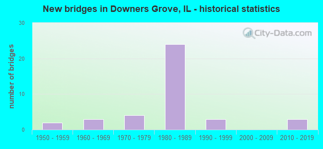
- New bridges - historical statistics
- 21950-1959
- 31960-1969
- 41970-1979
- 241980-1989
- 31990-1999
- 32010-2019

- Reconstructed bridges - Historical Statistics
- 11980-1989
- 01990-1999
- 12000-2009


- Bridge Condition - Deck
- 13.3%Good
- 80.0%Satisfactory
- 6.7%Fair

- Bridge Condition - Superstructure
- 6.7%Very good
- 33.3%Good
- 46.7%Satisfactory
- 13.3%Fair

- Bridge Condition - Substructure
- 6.7%Very good
- 40.0%Good
- 40.0%Satisfactory
- 13.3%Fair

- Bridge Condition - Channel
- 20.0%Excellent
- 10.0%Very good
- 40.0%Good
- 20.0%Satisfactory
- 10.0%Fair

- Bridge Condition - Culverts
- 25.0%Good
- 50.0%Satisfactory
- 25.0%Fair
Find on map >> Show street view
Structure Number: 220057, Location: 0.34 M E IL 53 (Lat: 41.831536, Lng: -88.047886), Route carried "on" structure: State highway 56, Year Built: 1973, Year Reconstructed: 1991, Status: Open, Structure Length: 2.14m (7.02ft), Average Daily Traffic: 30,700 (year 2021), Truck Traffic: 2%, Average Future Daily Traffic: 18,771 (year 2032), Design Load: HS 20, Features Intersected: E BR DUPAGE RIVER
Minimum Vertical Clearance: 30+ m (98+ ft), Kilometerpoint: 36.724, Lanes on structure: 4, Base Highway Network: Yes, Owner: State Highway Agency, Approaching Roadway Width: 27.4m (89.9ft), Skew: 32 degrees, Material/Design: Steel, Design/Construction: Stringer/Multi-beam, Number Of Spans In Main Unit: 1, Length of Maximum Span: 19.8m (65.0ft), Curb or Sidewalk Widths: Left: 0.0m, Right: 1.7m (5.6ft), Curb-To-Curb Width: 20.7m (67.9ft), Out-to-Out Width: 29.7m (97.4ft)
Condition: Deck: Satisfactory, Superstructure: Fair, Substructure: Satisfactory, Channel: Good, Operating Rating: 89.1 metric tons, Method Used To Determine Operating Rating: Load Factor (LF) rating reported by rating factor (RF) method using MS18 loading, Inventory Rating: 56.4 metric tons, Method Used To Determine Inventory Rating: Load Factor (LF) rating reported by rating factor (RF) method using MS18 loading, Structural Evaluation: Somewhat better than minimum adequacy, Deck Geometry: Superior to present desirable criteria, Waterway Adequacy: Better than present minimum criteria, Approach Roadway Alignment: Better than present minimum criteria, Designated Inspection Frequency: Every 24 months, Inspection Date: Febuary 2021, Deck Structure Type: Concrete Cast-file-Place, Wearing Surface/Protective System: Wearing Surface: Other
Find on map >> Show street view
Structure Number: 220071, Location: 1 MI S OF US 34 (Lat: 41.792136, Lng: -88.037831), Route carried "on" structure: Other road , Year Built: 1977, Year Reconstructed: 2013, Status: Open, Structure Length: 0.98m (3.22ft), Average Daily Traffic: 13,400 (year 2020), Truck Traffic: 6%, Average Future Daily Traffic: 20,052 (year 2032), Design Load: HS 20, Features Intersected: ST JOSEPH CR, Facility Carried by Structure: CH-2 (BELMONT AVE)
Minimum Vertical Clearance: 30+ m (98+ ft), Kilometerpoint: 10.782, Lanes on structure: 4, Base Highway Network: Yes, Owner: County Highway Agency, Approaching Roadway Width: 17.7m (58.1ft), Material/Design: Concrete, Design/Construction: Slab, Number Of Spans In Main Unit: 1, Length of Maximum Span: 9.3m (30.5ft), Curb or Sidewalk Widths: Left: 1.5m (4.9ft), Right: 3.2m (10.5ft), Curb-To-Curb Width: 17.7m (58.1ft), Out-to-Out Width: 23.0m (75.5ft)
Condition: Deck: Fair, Superstructure: Fair, Substructure: Satisfactory, Channel: Good, Operating Rating: 62.2 metric tons, Method Used To Determine Operating Rating: Load Factor (LF) rating reported by rating factor (RF) method using MS18 loading, Inventory Rating: 37.3 metric tons, Method Used To Determine Inventory Rating: Load Factor (LF) rating reported by rating factor (RF) method using MS18 loading, Structural Evaluation: Somewhat better than minimum adequacy, Deck Geometry: Somewhat better than minimum adequacy, Waterway Adequacy: Better than present minimum criteria, Approach Roadway Alignment: Equal to present desirable criteria, Length Of Structure Improvement: 1.68m (5.51ft), Designated Inspection Frequency: Every 24 months, Inspection Date: October 2021, Bridge Improvement Cost: $278,000, Roadway Improvement Cost: $28,000, Total Project Cost: $417,000, Deck Structure Type: Concrete Cast-file-Place, Wearing Surface/Protective System: Wearing Surface: Bituminous
Find on map >> Show street view
Structure Number: 220183, Location: .5 MI S. US 34 (Lat: 41.795586, Lng: -88.056992), Route carried "on" structure: Interstate 355, Year Built: 1988, Status: Open, Structure Length: 0.92m (3.02ft), Average Daily Traffic: 59,000 (year 2020), Truck Traffic: 12%, Average Future Daily Traffic: 76,420 (year 2032), Design Load: HS 20, Features Intersected: ST.JOSEPH CREEK
Minimum Vertical Clearance: 30+ m (98+ ft), Kilometerpoint: 30.899, Lanes on structure: 6, Base Highway Network: Yes, Toll: On toll road, Owner: State Toll Authority, Approaching Roadway Width: 45.1m (148.0ft), Skew: 2 degrees, Material/Design: Concrete, Design/Construction: Culvert, Number Of Spans In Main Unit: 2, Length of Maximum Span: 3.7m (12.1ft)
Condition: Channel: Excellent, Culverts: Satisfactory, Operating Rating: 54.1 metric tons, Method Used To Determine Operating Rating: Load Factor (LF) rating reported by rating factor (RF) method using MS18 loading, Inventory Rating: 32.4 metric tons, Method Used To Determine Inventory Rating: Load Factor (LF) rating reported by rating factor (RF) method using MS18 loading, Structural Evaluation: Equal to present minimum criteria, Waterway Adequacy: Superior to present desirable criteria, Approach Roadway Alignment: Equal to present desirable criteria, Designated Inspection Frequency: Every 24 months, Inspection Date: September 2019, Deck Structure Type: Concrete Cast-file-Place
Find on map >> Show street view
Structure Number: 220184, Location: 2 MI N. OF US 34 (Lat: 41.816819, Lng: -88.028225), Route carried "on" structure: Interstate 355, Year Built: 1988, Status: Open, Structure Length: 0.86m (2.82ft), Average Daily Traffic: 59,000 (year 2020), Truck Traffic: 22%, Average Future Daily Traffic: 95,247 (year 2032), Design Load: HS 20, Features Intersected: LACEY CREEK
Minimum Vertical Clearance: 30+ m (98+ ft), Kilometerpoint: 34.906, Lanes on structure: 8, Base Highway Network: Yes, Toll: On toll road, Owner: State Toll Authority, Approaching Roadway Width: 42.7m (140.1ft), Skew: 3 degrees, Material/Design: Concrete, Design/Construction: Culvert, Number Of Spans In Main Unit: 2, Length of Maximum Span: 3.7m (12.1ft)
Condition: Channel: Excellent, Culverts: Satisfactory, Operating Rating: 97.2 metric tons, Method Used To Determine Operating Rating: Load Factor (LF) rating reported by rating factor (RF) method using MS18 loading, Inventory Rating: 97.2 metric tons, Method Used To Determine Inventory Rating: Load Factor (LF) rating reported by rating factor (RF) method using MS18 loading, Structural Evaluation: Equal to present minimum criteria, Waterway Adequacy: Superior to present desirable criteria, Approach Roadway Alignment: Superior to present desirable criteria, Designated Inspection Frequency: Every 24 months, Inspection Date: August 2019, Deck Structure Type: Concrete Cast-file-Place
Find on map >> Show street view
Structure Number: 22022, Location: 1 M E OF IL 53 (Lat: 41.832922, Lng: -88.029375), Route carried "on" structure: State highway 56, Year Built: 1988, Status: Open, Structure Length: 9.36m (30.71ft), Average Daily Traffic: 30,700 (year 2021), Truck Traffic: 2%, Average Future Daily Traffic: 37,542 (year 2032), Design Load: HS 20, Features Intersected: I-355
Minimum Vertical Clearance: 30+ m (98+ ft), Kilometerpoint: 38.285, Lanes on structure: 10, Lanes under structure: 9, Base Highway Network: Yes, Owner: State Highway Agency, Approaching Roadway Width: 40.2m (131.9ft), Skew: 30 degrees, Material/Design: Prestressed concrete continuous, Design/Construction: Stringer/Multi-beam, Number Of Spans In Main Unit: 4, Length of Maximum Span: 26.8m (87.9ft), Curb-To-Curb Width: 38.4m (126.0ft), Out-to-Out Width: 41.5m (136.2ft)
Condition: Deck: Satisfactory, Superstructure: Good, Substructure: Satisfactory, Operating Rating: 72.6 metric tons, Method Used To Determine Operating Rating: Load Factor (LF) rating reported by rating factor (RF) method using MS18 loading, Inventory Rating: 43.4 metric tons, Method Used To Determine Inventory Rating: Load Factor (LF) rating reported by rating factor (RF) method using MS18 loading, Structural Evaluation: Equal to present minimum criteria, Deck Geometry: Somewhat better than minimum adequacy, Underclear: Somewhat better than minimum adequacy, Approach Roadway Alignment: Better than present minimum criteria, Designated Inspection Frequency: Every 24 months, Inspection Date: May 2019, Deck Structure Type: Concrete Cast-file-Place, Wearing Surface/Protective System: Deck Protection: Epoxy Coated Reinforcing
Find on map >> Show street view
Structure Number: 225003, Location: 0.8 Mi. N. of US 34 (Lat: 41.816097, Lng: -88.029492), Route carried "on" structure: Other road , Year Built: 1987, Status: Open, Structure Length: 0.69m (2.26ft), Average Daily Traffic: 10,900 (year 2020), Truck Traffic: 4%, Average Future Daily Traffic: 24,960 (year 2038), Design Load: HS 20+Mod, Features Intersected: Lacey Creek, Facility Carried by Structure: Finley Road
Minimum Vertical Clearance: 30+ m (98+ ft), Kilometerpoint: 7.773, Lanes on structure: 5, Base Highway Network: Yes, Owner: County Highway Agency, Approaching Roadway Width: 14.6m (47.9ft), Material/Design: Concrete, Design/Construction: Culvert, Number Of Spans In Main Unit: 2, Length of Maximum Span: 3.3m (10.8ft)
Condition: Channel: Very good, Culverts: Good, Operating Rating: 53.8 metric tons, Method Used To Determine Operating Rating: Assigned rating based on Load Factor Design (LFD) reported by rating factor (RF) using MS18 loading, Inventory Rating: 32.4 metric tons, Method Used To Determine Inventory Rating: Assigned rating based on Load Factor Design (LFD) reported by rating factor (RF) using MS18 loading, Structural Evaluation: Better than present minimum criteria, Waterway Adequacy: Equal to present desirable criteria, Approach Roadway Alignment: Equal to present desirable criteria, Designated Inspection Frequency: Every 24 months, Inspection Date: May 2020
Find on map >> Show street view
Structure Number: 226002, Location: 0.14 S HADDOW AVE (Lat: 41.795708, Lng: -88.037828), Route carried "on" structure: City street , Year Built: 2012, Status: Open, Structure Length: 2.18m (7.15ft), Average Daily Traffic: 1,650 (year 2020), Truck Traffic: 7%, Average Future Daily Traffic: 2,640 (year 2038), Design Load: HS 20, Features Intersected: BELMONT ROAD, Facility Carried by Structure: BURLINGTON/WARREN
Minimum Vertical Clearance: 30+ m (98+ ft), Kilometerpoint: 1.223, Lanes on structure: 2, Lanes under structure: 4, Owner: County Highway Agency, Approaching Roadway Width: 9.1m (29.9ft), Material/Design: Steel continuous, Design/Construction: Stringer/Multi-beam, Number Of Spans In Main Unit: 1, Length of Maximum Span: 20.8m (68.2ft), Curb or Sidewalk Widths: Left: 3.0m (9.8ft), Right: 1.8m (5.9ft), Curb-To-Curb Width: 9.1m (29.9ft), Out-to-Out Width: 14.6m (47.9ft)
Condition: Deck: Good, Superstructure: Very good, Substructure: Very good, Operating Rating: 88.5 metric tons, Method Used To Determine Operating Rating: Load Factor (LF) rating reported by rating factor (RF) method using MS18 loading, Inventory Rating: 52.8 metric tons, Method Used To Determine Inventory Rating: Load Factor (LF) rating reported by rating factor (RF) method using MS18 loading, Structural Evaluation: Equal to present desirable criteria, Deck Geometry: Somewhat better than minimum adequacy, Underclear: Meets minimum limits, Approach Roadway Alignment: Equal to present desirable criteria, Designated Inspection Frequency: Every 48 months, Inspection Date: June 2021, Deck Structure Type: Concrete Cast-file-Place, Wearing Surface/Protective System: Membrane: Other, Deck Protection: Epoxy Coated Reinforcing
Find on map >> Show street view
Structure Number: 22635, Location: 0.3 MI S 63RD ST (Lat: 41.768819, Lng: -88.031669), Route carried "on" structure: Other road , Year Built: 1973, Status: Open, Structure Length: 1.01m (3.31ft), Average Daily Traffic: 12,300 (year 2020), Truck Traffic: 5%, Average Future Daily Traffic: 17,267 (year 2032), Design Load: HS 20, Features Intersected: PRENTISS CREEK, Facility Carried by Structure: WOODWARD AVE
Minimum Vertical Clearance: 30+ m (98+ ft), Kilometerpoint: 0.402, Lanes on structure: 4, Base Highway Network: Yes, Owner: City or Municipal Highway Agency, Approaching Roadway Width: 13.4m (44.0ft), Material/Design: Concrete, Design/Construction: Culvert, Number Of Spans In Main Unit: 3, Length of Maximum Span: 3.0m (9.8ft), Curb or Sidewalk Widths: Left: 1.5m (4.9ft), Right: 1.5m (4.9ft), Curb-To-Curb Width: 13.3m (43.6ft), Out-to-Out Width: 30.2m (99.1ft)
Condition: Channel: Satisfactory, Culverts: Fair, Operating Rating: 53.8 metric tons, Method Used To Determine Operating Rating: Field evaluation and documented engineering judgment, Inventory Rating: 32.4 metric tons, Method Used To Determine Inventory Rating: Field evaluation and documented engineering judgment, Structural Evaluation: Somewhat better than minimum adequacy, Deck Geometry: High priority of replacement, Waterway Adequacy: Equal to present desirable criteria, Approach Roadway Alignment: Equal to present desirable criteria, Length Of Structure Improvement: 1.62m (5.31ft), Designated Inspection Frequency: Every 24 months, Inspection Date: May 2021, Bridge Improvement Cost: $287,000, Roadway Improvement Cost: $29,000, Total Project Cost: $431,000, Wearing Surface/Protective System: Wearing Surface: Bituminous
Find on map >> Show street view
Structure Number: 226351, Location: .3 MI E WOODWARD AVE (Lat: 41.769269, Lng: -88.025961), Route carried "on" structure: Other road , Year Built: 1973, Status: Open, Structure Length: 0.91m (2.99ft), Average Daily Traffic: 825 (year 2020), Truck Traffic: 3%, Average Future Daily Traffic: 501 (year 2032), Design Load: HS 20, Features Intersected: PRENTISS CREEK, Facility Carried by Structure: PRENTISS DRIVE
Minimum Vertical Clearance: 30+ m (98+ ft), Kilometerpoint: 0.483, Lanes on structure: 2, Owner: City or Municipal Highway Agency, Approaching Roadway Width: 11.0m (36.1ft), Skew: 1 degrees, Material/Design: Concrete, Design/Construction: Culvert, Number Of Spans In Main Unit: 3, Length of Maximum Span: 3.0m (9.8ft), Curb or Sidewalk Widths: Left: 1.5m (4.9ft), Right: 1.5m (4.9ft), Curb-To-Curb Width: 11.0m (36.1ft), Out-to-Out Width: 25.0m (82.0ft)
Condition: Channel: Good, Culverts: Fair, Operating Rating: 53.8 metric tons, Method Used To Determine Operating Rating: Field evaluation and documented engineering judgment, Inventory Rating: 32.4 metric tons, Method Used To Determine Inventory Rating: Field evaluation and documented engineering judgment, Structural Evaluation: Somewhat better than minimum adequacy, Deck Geometry: Better than present minimum criteria, Waterway Adequacy: Equal to present desirable criteria, Approach Roadway Alignment: Equal to present desirable criteria, Designated Inspection Frequency: Every 24 months, Inspection Date: May 2021, Wearing Surface/Protective System: Wearing Surface: Bituminous
Find on map >> Show street view
Structure Number: 226352, Location: 400 FT S BN RR (Lat: 41.794817, Lng: -88.027708), Route carried "on" structure: Other road , Year Built: 1961, Status: Open, Structure Length: 0.79m (2.59ft), Average Daily Traffic: 600 (year 2020), Truck Traffic: 58%, Average Future Daily Traffic: 1,058 (year 2032), Features Intersected: ST. JOSEPH CREEK, Facility Carried by Structure: LEE AVE
Minimum Vertical Clearance: 30+ m (98+ ft), Kilometerpoint: 0.048, Lanes on structure: 2, Owner: City or Municipal Highway Agency, Approaching Roadway Width: 6.4m (21.0ft), Skew: 1 degrees, Material/Design: Concrete, Design/Construction: Culvert, Number Of Spans In Main Unit: 2, Length of Maximum Span: 4.0m (13.1ft), Curb or Sidewalk Widths: Left: 0.0m, Right: 1.5m (4.9ft), Curb-To-Curb Width: 12.9m (42.3ft), Out-to-Out Width: 13.5m (44.3ft)
Condition: Channel: Fair, Culverts: Satisfactory, Operating Rating: 40.5 metric tons, Method Used To Determine Operating Rating: Field evaluation and documented engineering judgment, Inventory Rating: 24.3 metric tons, Method Used To Determine Inventory Rating: Field evaluation and documented engineering judgment, Structural Evaluation: Equal to present minimum criteria, Deck Geometry: Superior to present desirable criteria, Waterway Adequacy: Equal to present desirable criteria, Approach Roadway Alignment: Better than present minimum criteria, Designated Inspection Frequency: Every 24 months, Inspection Date: August 2020, Wearing Surface/Protective System: Wearing Surface: Bituminous
Find on map >> Show street view
Structure Number: 226353, Location: .1 MI S B N RR (Lat: 41.792664, Lng: -88.019086), Route carried "on" structure: City street , Year Built: 1961, Status: Open, Structure Length: 0.67m (2.20ft), Average Daily Traffic: 50 (year 2020), Truck Traffic: 20%, Average Future Daily Traffic: 344 (year 2032), Features Intersected: ST.JOSEPH CREEK, Facility Carried by Structure: BROOKBANK AVE
Minimum Vertical Clearance: 30+ m (98+ ft), Kilometerpoint: 0.097, Lanes on structure: 2, Owner: City or Municipal Highway Agency, Approaching Roadway Width: 6.1m (20.0ft), Material/Design: Concrete, Design/Construction: Culvert, Number Of Spans In Main Unit: 2, Length of Maximum Span: 3.0m (9.8ft), Curb-To-Curb Width: 6.1m (20.0ft), Out-to-Out Width: 6.7m (22.0ft)
Condition: Channel: Satisfactory, Culverts: Satisfactory, Operating Rating: 40.5 metric tons, Method Used To Determine Operating Rating: Field evaluation and documented engineering judgment, Inventory Rating: 24.3 metric tons, Method Used To Determine Inventory Rating: Field evaluation and documented engineering judgment, Structural Evaluation: Equal to present minimum criteria, Deck Geometry: Somewhat better than minimum adequacy, Waterway Adequacy: Better than present minimum criteria, Approach Roadway Alignment: Somewhat better than minimum adequacy, Designated Inspection Frequency: Every 24 months, Inspection Date: August 2020, Wearing Surface/Protective System: Wearing Surface: Bituminous
Find on map >> Show street view
Structure Number: 226354, Location: 400 FT S GILBERT (Lat: 41.793047, Lng: -88.022914), Route carried "on" structure: City street , Year Built: 1961, Status: Open, Structure Length: 0.82m (2.69ft), Average Daily Traffic: 75 (year 2020), Average Future Daily Traffic: 233 (year 2032), Features Intersected: ST.JOSEPH CREEK, Facility Carried by Structure: JACQUELINE DRIVE
Minimum Vertical Clearance: 30+ m (98+ ft), Kilometerpoint: 0.129, Lanes on structure: 2, Owner: City or Municipal Highway Agency, Approaching Roadway Width: 3.4m (11.2ft), Skew: 3 degrees, Material/Design: Concrete, Design/Construction: Culvert, Number Of Spans In Main Unit: 2, Length of Maximum Span: 3.7m (12.1ft), Curb-To-Curb Width: 6.1m (20.0ft), Out-to-Out Width: 6.7m (22.0ft)
Condition: Channel: Good, Culverts: Good, Operating Rating: 40.5 metric tons, Method Used To Determine Operating Rating: Field evaluation and documented engineering judgment, Inventory Rating: 24.3 metric tons, Method Used To Determine Inventory Rating: Field evaluation and documented engineering judgment, Structural Evaluation: Equal to present minimum criteria, Deck Geometry: Somewhat better than minimum adequacy, Waterway Adequacy: Better than present minimum criteria, Approach Roadway Alignment: Somewhat better than minimum adequacy, Designated Inspection Frequency: Every 24 months, Inspection Date: August 2020, Wearing Surface/Protective System: Wearing Surface: Bituminous
Find on map >> Show street view
Structure Number: 229903, Location: 02 M SO OF ILL 56 (Lat: 41.833383, Lng: -88.011036), Route carried "on" structure: Other road , Year Built: 1958, Status: Open, Structure Length: 7.04m (23.10ft), Average Future Daily Traffic: 15,875 (year 2032), Design Load: HS 20, Features Intersected: I-88 E-W TOLL RD., Facility Carried by Structure: HIGHLAND AVE
Minimum Vertical Clearance: 30+ m (98+ ft), Kilometerpoint: 21.500, Lanes on structure: 4, Lanes under structure: 4, Base Highway Network: Yes, Owner: County Highway Agency, Approaching Roadway Width: 17.7m (58.1ft), Skew: 31 degrees, Material/Design: Prestressed concrete, Design/Construction: Stringer/Multi-beam, Number Of Spans In Main Unit: 4, Length of Maximum Span: 21.0m (68.9ft), Curb or Sidewalk Widths: Left: 0.6m (2.0ft), Right: 0.6m (2.0ft), Curb-To-Curb Width: 17.7m (58.1ft), Out-to-Out Width: 20.7m (67.9ft)
Condition: Deck: Satisfactory, Superstructure: Good, Substructure: Good, Operating Rating: 64.5 metric tons, Method Used To Determine Operating Rating: Load Factor (LF) rating reported by rating factor (RF) method using MS18 loading, Inventory Rating: 38.6 metric tons, Method Used To Determine Inventory Rating: Load Factor (LF) rating reported by rating factor (RF) method using MS18 loading, Structural Evaluation: Better than present minimum criteria, Deck Geometry: Somewhat better than minimum adequacy, Underclear: Meets minimum limits, Approach Roadway Alignment: Equal to present desirable criteria, Length Of Structure Improvement: 7.04m (23.10ft), Designated Inspection Frequency: Every 24 months, Inspection Date: September 2020, Bridge Improvement Cost: $829,000, Roadway Improvement Cost: $83,000, Total Project Cost: $1,244,000, Deck Structure Type: Concrete Cast-file-Place, Wearing Surface/Protective System: Wearing Surface: Bituminous, Membrane: Built-up
Find on map >> Show street view
Structure Number: 229966, Location: 0.8 M.N. OF US-34 (Lat: 41.820756, Lng: -88.028397), Route carried "on" structure: Interstate 355, Year Built: 1989, Status: Open, Structure Length: 16.03m (52.59ft), Average Daily Traffic: 59,000 (year 2020), Truck Traffic: 22%, Average Future Daily Traffic: 95,247 (year 2032), Features Intersected: FINLEY RD & RAMP
Minimum Vertical Clearance: 30+ m (98+ ft), Kilometerpoint: 35.324, Lanes on structure: 7, Lanes under structure: 2, Base Highway Network: Yes, Toll: On toll road, Owner: State Toll Authority, Approaching Roadway Width: 41.5m (136.2ft), Skew: 30 degrees, Material/Design: Steel, Design/Construction: Stringer/Multi-beam, Number Of Spans In Main Unit: 4, Length of Maximum Span: 56.4m (185.0ft), Curb-To-Curb Width: 40.5m (132.9ft), Out-to-Out Width: 42.5m (139.4ft)
Condition: Deck: Satisfactory, Superstructure: Satisfactory, Substructure: Satisfactory, Operating Rating: 82.6 metric tons, Method Used To Determine Operating Rating: Load Factor (LF) rating reported by rating factor (RF) method using MS18 loading, Inventory Rating: 49.6 metric tons, Method Used To Determine Inventory Rating: Load Factor (LF) rating reported by rating factor (RF) method using MS18 loading, Structural Evaluation: Equal to present minimum criteria, Deck Geometry: Superior to present desirable criteria, Underclear: Superior to present desirable criteria, Approach Roadway Alignment: Equal to present desirable criteria, Designated Inspection Frequency: Every 24 months, Inspection Date: September 2020, Deck Structure Type: Concrete Cast-file-Place
Find on map >> Show street view
Structure Number: 229967, Location: 1.1 M.N. OF US-34 (Lat: 41.824114, Lng: -88.025239), Route carried "on" structure: Other road , Year Built: 1989, Status: Open, Structure Length: 5.30m (17.39ft), Average Daily Traffic: 7,300 (year 2020), Truck Traffic: 16%, Average Future Daily Traffic: 3,119 (year 2032), Features Intersected: FINLEY RD, Facility Carried by Structure: I-88 WB TO I-355 N
Minimum Vertical Clearance: 30+ m (98+ ft), Kilometerpoint: 0.499, Lanes on structure: 2, Lanes under structure: 2, Base Highway Network: Yes (Inventory Route: 10355Q41, Subroute: 10), Owner: State Toll Authority, Approaching Roadway Width: 9.8m (32.2ft), Material/Design: Prestressed concrete, Design/Construction: Stringer/Multi-beam, Number Of Spans In Main Unit: 3, Length of Maximum Span: 23.5m (77.1ft), Curb-To-Curb Width: 9.8m (32.2ft), Out-to-Out Width: 11.0m (36.1ft)
Condition: Deck: Satisfactory, Superstructure: Satisfactory, Substructure: Fair, Operating Rating: 59.9 metric tons, Method Used To Determine Operating Rating: Load Factor (LF) rating reported by rating factor (RF) method using MS18 loading, Inventory Rating: 36.0 metric tons, Method Used To Determine Inventory Rating: Load Factor (LF) rating reported by rating factor (RF) method using MS18 loading, Structural Evaluation: Somewhat better than minimum adequacy, Deck Geometry: High priority of replacement, Underclear: Somewhat better than minimum adequacy, Approach Roadway Alignment: Equal to present desirable criteria, Designated Inspection Frequency: Every 24 months, Inspection Date: September 2020, Deck Structure Type: Concrete Cast-file-Place
Find on map >> Show street view
Structure Number: 229968, Location: 0.2 M.N. OF US-34 (Lat: 41.810319, Lng: -88.036178), Route carried "on" structure: Other road , Year Built: 1989, Status: Open, Structure Length: 16.76m (54.99ft), Average Daily Traffic: 5,450 (year 2020), Truck Traffic: 4%, Average Future Daily Traffic: 4,289 (year 2032), Design Load: HS 20, Features Intersected: I-88 & I-355, Facility Carried by Structure: FINLEY RD
Minimum Vertical Clearance: 30+ m (98+ ft), Kilometerpoint: 8.690, Lanes on structure: 2, Lanes under structure: 14, Base Highway Network: Yes, Owner: County Highway Agency, Approaching Roadway Width: 7.9m (25.9ft), Material/Design: Prestressed concrete, Design/Construction: Segmental Box Girder, Number Of Spans In Main Unit: 6, Length of Maximum Span: 48.6m (159.4ft), Curb or Sidewalk Widths: Left: 0.0m, Right: 1.5m (4.9ft), Curb-To-Curb Width: 7.9m (25.9ft), Out-to-Out Width: 8.8m (28.9ft)
Condition: Deck: Good, Superstructure: Good, Substructure: Good, Operating Rating: 44.4 metric tons, Method Used To Determine Operating Rating: Assigned rating based on Load Factor Design (LFD) reported by rating factor (RF) using MS18 loading, Inventory Rating: 32.4 metric tons, Method Used To Determine Inventory Rating: Assigned rating based on Load Factor Design (LFD) reported by rating factor (RF) using MS18 loading, Structural Evaluation: Better than present minimum criteria, Deck Geometry: High priority of replacement, Underclear: High priority of replacement, Approach Roadway Alignment: Equal to present desirable criteria, Length Of Structure Improvement: 17.62m (57.81ft), Designated Inspection Frequency: Every 24 months, Inspection Date: July 2020, Bridge Improvement Cost: $1,684,000, Roadway Improvement Cost: $168,000, Total Project Cost: $2,526,000, Deck Structure Type: Other
Find on map >> Show street view
Structure Number: 229969, Location: 0.1 M.E. OF FINLEY (Lat: 41.814528, Lng: -88.027703), Route carried "on" structure: Other road , Year Built: 1989, Status: Open, Structure Length: 16.09m (52.79ft), Average Daily Traffic: 1,200 (year 2020), Average Future Daily Traffic: 9,600 (year 2041), Features Intersected: I-88, Facility Carried by Structure: I-88 EB TO I-355 N
Minimum Vertical Clearance: 30+ m (98+ ft), Kilometerpoint: 0.660, Lanes on structure: 1, Lanes under structure: 8, Base Highway Network: Yes, Toll: On toll road, Owner: State Toll Authority, Approaching Roadway Width: 8.8m (28.9ft), Material/Design: Prestressed concrete, Design/Construction: Segmental Box Girder, Number Of Spans In Main Unit: 7, Length of Maximum Span: 23.2m (76.1ft), Curb-To-Curb Width: 9.0m (29.5ft), Out-to-Out Width: 10.1m (33.1ft)
Condition: Deck: Satisfactory, Superstructure: Satisfactory, Substructure: Satisfactory, Operating Rating: 89.1 metric tons, Method Used To Determine Operating Rating: Load Factor (LF), Inventory Rating: 66.1 metric tons, Method Used To Determine Inventory Rating: Load Factor (LF), Structural Evaluation: Equal to present minimum criteria, Deck Geometry: Somewhat better than minimum adequacy, Underclear: High priority of corrective action, Approach Roadway Alignment: Equal to present desirable criteria, Designated Inspection Frequency: Every 24 months, Inspection Date: May 2020, Deck Structure Type: Other
Find on map >> Show street view
Structure Number: 22997, Location: 1.3 M.E. OF IL-53 (Lat: 41.824183, Lng: -88.028958), Route carried "on" structure: Other road , Year Built: 1989, Status: Open, Structure Length: 61.60m (202.10ft), Average Daily Traffic: 8,000 (year 2020), Average Future Daily Traffic: 8,021 (year 2032), Features Intersected: I-355,FINLEY & RAMPS, Facility Carried by Structure: I-355 SB TO I-88 W
Minimum Vertical Clearance: 30+ m (98+ ft), Kilometerpoint: 0.016, Lanes on structure: 1, Lanes under structure: 9, Base Highway Network: Yes (Inventory Route: 10355S40, Subroute: 70), Owner: State Toll Authority, Approaching Roadway Width: 10.1m (33.1ft), Material/Design: Prestressed concrete, Design/Construction: Segmental Box Girder, Number Of Spans In Main Unit: 12, Length of Maximum Span: 51.2m (168.0ft), Curb-To-Curb Width: 10.1m (33.1ft), Out-to-Out Width: 11.3m (37.1ft)
Condition: Deck: Satisfactory, Superstructure: Satisfactory, Substructure: Fair, Operating Rating: 89.1 metric tons, Method Used To Determine Operating Rating: Load Factor (LF) rating reported by rating factor (RF) method using MS18 loading, Inventory Rating: 55.1 metric tons, Method Used To Determine Inventory Rating: Load Factor (LF) rating reported by rating factor (RF) method using MS18 loading, Structural Evaluation: Somewhat better than minimum adequacy, Deck Geometry: Meets minimum limits, Underclear: High priority of corrective action, Approach Roadway Alignment: Equal to present desirable criteria, Designated Inspection Frequency: Every 24 months, Inspection Date: June 2020, Deck Structure Type: Concrete Cast-file-Place
Find on map >> Show street view
Structure Number: 229971, Location: 1.3 M.E. OF IL-53 (Lat: 41.827258, Lng: -88.028914), Route carried "on" structure: Other road , Year Built: 1989, Status: Open, Structure Length: 59.86m (196.39ft), Average Daily Traffic: 10,250 (year 2020), Truck Traffic: 24%, Average Future Daily Traffic: 16,264 (year 2032), Design Load: HS 20, Features Intersected: I-355,FINLEY & I-88, Facility Carried by Structure: I-355 SB TO I-88 E
Minimum Vertical Clearance: 30+ m (98+ ft), Kilometerpoint: 0.016, Lanes on structure: 1, Lanes under structure: 8, Base Highway Network: Yes (Inventory Route: 10355T40, Subroute: 70), Toll: On toll road, Owner: State Toll Authority, Approaching Roadway Width: 10.1m (33.1ft), Material/Design: Prestressed concrete, Design/Construction: Segmental Box Girder, Number Of Spans In Main Unit: 12, Length of Maximum Span: 49.9m (163.7ft), Curb-To-Curb Width: 10.1m (33.1ft), Out-to-Out Width: 11.3m (37.1ft)
Condition: Deck: Satisfactory, Superstructure: Satisfactory, Substructure: Satisfactory, Operating Rating: 68.7 metric tons, Method Used To Determine Operating Rating: Load Factor (LF) rating reported by rating factor (RF) method using MS18 loading, Inventory Rating: 41.5 metric tons, Method Used To Determine Inventory Rating: Load Factor (LF) rating reported by rating factor (RF) method using MS18 loading, Structural Evaluation: Equal to present minimum criteria, Deck Geometry: Meets minimum limits, Underclear: Meets minimum limits, Approach Roadway Alignment: Equal to present desirable criteria, Designated Inspection Frequency: Every 24 months, Inspection Date: June 2020, Deck Structure Type: Concrete Cast-file-Place, Wearing Surface/Protective System: Wearing Surface: Epoxy Overlay, Deck Protection: Epoxy Coated Reinforcing
Find on map >> Show street view
Structure Number: 229979, Location: 1M.E.OF IL-53 (Lat: 41.797306, Lng: -88.057050), Route carried "on" structure: Interstate 355, Year Built: 1989, Status: Open, Structure Length: 5.85m (19.19ft), Average Daily Traffic: 118,000 (year 2020), Truck Traffic: 12%, Average Future Daily Traffic: 152,841 (year 2032), Features Intersected: BN RR
Minimum Vertical Clearance: 30+ m (98+ ft), Kilometerpoint: 31.092, Lanes on structure: 9, Base Highway Network: Yes, Toll: On toll road, Owner: State Toll Authority, Approaching Roadway Width: 50.9m (167.0ft), Skew: 31 degrees, Material/Design: Prestressed concrete, Design/Construction: Stringer/Multi-beam, Number Of Spans In Main Unit: 3, Length of Maximum Span: 24.8m (81.4ft), Curb-To-Curb Width: 50.2m (164.7ft), Out-to-Out Width: 51.7m (169.6ft)
Condition: Deck: Satisfactory, Superstructure: Good, Substructure: Good, Operating Rating: 70.0 metric tons, Method Used To Determine Operating Rating: Load Factor (LF) rating reported by rating factor (RF) method using MS18 loading, Inventory Rating: 41.8 metric tons, Method Used To Determine Inventory Rating: Load Factor (LF) rating reported by rating factor (RF) method using MS18 loading, Structural Evaluation: Better than present minimum criteria, Deck Geometry: Superior to present desirable criteria, Underclear: High priority of corrective action, Approach Roadway Alignment: Equal to present desirable criteria, Length Of Structure Improvement: 5.85m (19.19ft), Designated Inspection Frequency: Every 24 months, Inspection Date: April 2020, Bridge Improvement Cost: $521,000, Roadway Improvement Cost: $52,000, Total Project Cost: $625,000, Deck Structure Type: Concrete Cast-file-Place
Find on map >> Show street view
Structure Number: 22998, Location: 1M.E.OF IL-53 (Lat: 41.793583, Lng: -88.056914), Route carried "on" structure: Interstate 355, Year Built: 1989, Status: Open, Structure Length: 3.66m (12.01ft), Average Daily Traffic: 118,000 (year 2020), Truck Traffic: 12%, Average Future Daily Traffic: 152,841 (year 2032), Features Intersected: HITCHCOCK AVE.
Minimum Vertical Clearance: 30+ m (98+ ft), Kilometerpoint: 30.673, Lanes on structure: 7, Lanes under structure: 2, Base Highway Network: Yes, Toll: On toll road, Owner: State Toll Authority, Approaching Roadway Width: 45.7m (149.9ft), Skew: 30 degrees, Material/Design: Prestressed concrete, Design/Construction: Stringer/Multi-beam, Number Of Spans In Main Unit: 1, Length of Maximum Span: 36.0m (118.1ft), Curb-To-Curb Width: 44.9m (147.3ft), Out-to-Out Width: 46.4m (152.2ft)
Condition: Deck: Satisfactory, Superstructure: Good, Substructure: Good, Operating Rating: 92.7 metric tons, Method Used To Determine Operating Rating: Load Factor (LF) rating reported by rating factor (RF) method using MS18 loading, Inventory Rating: 55.4 metric tons, Method Used To Determine Inventory Rating: Load Factor (LF) rating reported by rating factor (RF) method using MS18 loading, Structural Evaluation: Better than present minimum criteria, Deck Geometry: Superior to present desirable criteria, Underclear: Somewhat better than minimum adequacy, Approach Roadway Alignment: Equal to present desirable criteria, Designated Inspection Frequency: Every 24 months, Inspection Date: April 2020, Deck Structure Type: Concrete Cast-file-Place
Find on map >> Show street view
Structure Number: 229981, Location: 1M.E.OF IL-53 (Lat: 41.786008, Lng: -88.056186), Route carried "on" structure: Other road , Year Built: 1989, Status: Open, Structure Length: 6.77m (22.21ft), Average Daily Traffic: 16,000 (year 2020), Truck Traffic: 4%, Average Future Daily Traffic: 27,182 (year 2032), Design Load: HS 20, Features Intersected: I-355, Facility Carried by Structure: MAPLE AVE.
Minimum Vertical Clearance: 30+ m (98+ ft), Kilometerpoint: 7.902, Lanes on structure: 8, Lanes under structure: 6, Base Highway Network: Yes, Owner: County Highway Agency, Approaching Roadway Width: 31.7m (104.0ft), Skew: 30 degrees, Material/Design: Prestressed concrete, Design/Construction: Stringer/Multi-beam, Number Of Spans In Main Unit: 2, Length of Maximum Span: 33.8m (110.9ft), Curb or Sidewalk Widths: Left: 1.5m (4.9ft), Right: 1.5m (4.9ft), Curb-To-Curb Width: 31.1m (102.0ft), Out-to-Out Width: 34.7m (113.8ft)
Condition: Deck: Satisfactory, Superstructure: Satisfactory, Substructure: Good, Operating Rating: 68.4 metric tons, Method Used To Determine Operating Rating: Load Factor (LF) rating reported by rating factor (RF) method using MS18 loading, Inventory Rating: 40.8 metric tons, Method Used To Determine Inventory Rating: Load Factor (LF) rating reported by rating factor (RF) method using MS18 loading, Structural Evaluation: Equal to present minimum criteria, Deck Geometry: Somewhat better than minimum adequacy, Underclear: Somewhat better than minimum adequacy, Approach Roadway Alignment: Equal to present desirable criteria, Designated Inspection Frequency: Every 24 months, Inspection Date: April 2020, Deck Structure Type: Concrete Cast-file-Place
Find on map >> Show street view
Structure Number: 229988, Location: 0.2 M.N. OF US-34 (Lat: 41.810319, Lng: -88.036178), Route carried "on" structure: Other road , Year Built: 1996, Status: Open, Structure Length: 16.86m (55.31ft), Average Daily Traffic: 5,450 (year 2020), Truck Traffic: 4%, Average Future Daily Traffic: 4,289 (year 2032), Design Load: HS 20, Features Intersected: I-355, Facility Carried by Structure: FINLEY RD
Minimum Vertical Clearance: 30+ m (98+ ft), Kilometerpoint: 8.690, Lanes on structure: 2, Lanes under structure: 14, Base Highway Network: Yes, Owner: County Highway Agency, Approaching Roadway Width: 11.0m (36.1ft), Material/Design: Prestressed concrete continuous, Design/Construction: Stringer/Multi-beam, Number Of Spans In Main Unit: 6, Length of Maximum Span: 39.6m (129.9ft), Curb-To-Curb Width: 9.1m (29.9ft), Out-to-Out Width: 11.0m (36.1ft)
Condition: Deck: Satisfactory, Superstructure: Satisfactory, Substructure: Good, Operating Rating: 59.0 metric tons, Method Used To Determine Operating Rating: Load Factor (LF) rating reported by rating factor (RF) method using MS18 loading, Inventory Rating: 35.3 metric tons, Method Used To Determine Inventory Rating: Load Factor (LF) rating reported by rating factor (RF) method using MS18 loading, Structural Evaluation: Equal to present minimum criteria, Deck Geometry: Meets minimum limits, Underclear: High priority of corrective action, Approach Roadway Alignment: Equal to present desirable criteria, Designated Inspection Frequency: Every 24 months, Inspection Date: July 2020, Deck Structure Type: Concrete Cast-file-Place
Find on map >> Show street view
Structure Number: 22022, Location: 1 M E OF IL 53 (Lat: 41.833397, Lng: -88.028950), Route carried "under" structure: Interstate 355, Year Built: 1988, Structure Length: 0. m, Average Daily Traffic: 67,800 (year 2020), Truck Traffic: 12%, Features Intersected: I-355, Facility Carried by Structure: IL 56
Minimum Vertical Clearance: 5.13m (16.83ft), Kilometerpoint: 36.708, Lanes on structure: 10, Lanes under structure: 9, Material/Design: Prestressed concrete continuous, Design/Construction: Stringer/Multi-beam, Length of Maximum Span: 26.8m (87.9ft)
Find on map >> Show street view
Structure Number: 226002, Location: 0.14 S HADDOW AVE (Lat: 41.795703, Lng: -88.037628), Route carried "under" structure: Other road , Year Built: 2012, Structure Length: 0. m, Average Daily Traffic: 13,400 (year 2020), Truck Traffic: 6%, Features Intersected: BELMONT ROAD, Facility Carried by Structure: BURLINGTON/WARREN
Minimum Vertical Clearance: 4.65m (15.26ft), Kilometerpoint: 10.364, Lanes on structure: 2, Lanes under structure: 4, Material/Design: Steel continuous, Design/Construction: Stringer/Multi-beam, Length of Maximum Span: 20.8m (68.2ft)
Find on map >> Show street view
Structure Number: 2298, Location: .01M S of Belmont (Lat: 41.795469, Lng: -88.037650), Route carried "under" structure: Other road , Year Built: 2012, Structure Length: 0. m, Average Daily Traffic: 13,400 (year 2020), Truck Traffic: 6%, Features Intersected: BELMONT ROAD, Facility Carried by Structure: BNSF RR
Minimum Vertical Clearance: 32.69m (107.25ft), Kilometerpoint: 10.396, Lanes under structure: 3, Material/Design: Steel continuous, Design/Construction: Stringer/Multi-beam, Length of Maximum Span: 21.5m (70.5ft)
Find on map >> Show street view
Structure Number: 229903, Location: 02 M SO OF ILL 56 (Lat: 41.833383, Lng: -88.011036), Route carried "under" structure: Interstate 88, Year Built: 1958, Structure Length: 0. m, Average Daily Traffic: 128,200 (year 2020), Truck Traffic: 15%, Features Intersected: I-88 E-W TOLL RD., Facility Carried by Structure: HIGHLAND AVE
Minimum Vertical Clearance: 4.70m (15.42ft), Kilometerpoint: 215.775, Lanes on structure: 4, Lanes under structure: 4, Material/Design: Prestressed concrete, Design/Construction: Stringer/Multi-beam, Length of Maximum Span: 21.0m (68.9ft)
Find on map >> Show street view
Structure Number: 229966, Location: 0.8 M.N. OF US-34 (Lat: 41.819886, Lng: -88.028358), Route carried "under" structure: Other road , Year Built: 1989, Structure Length: 0. m, Average Daily Traffic: 10,900 (year 2020), Truck Traffic: 4%, Features Intersected: FINLEY RD & RAMP, Facility Carried by Structure: I-355
Minimum Vertical Clearance: 5.31m (17.42ft), Kilometerpoint: 7.338, Lanes on structure: 7, Lanes under structure: 2, Toll: On toll road, Material/Design: Steel, Design/Construction: Stringer/Multi-beam, Length of Maximum Span: 56.4m (185.0ft)
Find on map >> Show street view
Structure Number: 229967, Location: 1.1 M.N. OF US-34 (Lat: 41.824178, Lng: -88.025242), Route carried "under" structure: Other road , Year Built: 1989, Structure Length: 0. m, Average Daily Traffic: 10,900 (year 2020), Truck Traffic: 4%, Features Intersected: FINLEY RD, Facility Carried by Structure: I-88 WB TO I-355 N
Minimum Vertical Clearance: 4.57m (14.99ft), Kilometerpoint: 6.759, Lanes on structure: 2, Lanes under structure: 2, Material/Design: Prestressed concrete, Design/Construction: Stringer/Multi-beam, Length of Maximum Span: 23.5m (77.1ft)
Find on map >> Show street view
Structure Number: 229968, Location: 0.2 M.N. OF US-34 (Lat: 41.810025, Lng: -88.036447), Route carried "under" structure: Interstate 355, Year Built: 1989, Structure Length: 0. m, Average Daily Traffic: 71,900 (year 2020), Truck Traffic: 18%, Features Intersected: I-88 & I-355, Facility Carried by Structure: FINLEY RD
Minimum Vertical Clearance: 6.45m (21.16ft), Kilometerpoint: 33.763, Lanes on structure: 2, Lanes under structure: 6, Material/Design: Prestressed concrete, Design/Construction: Segmental Box Girder, Length of Maximum Span: 48.6m (159.4ft)
Find on map >> Show street view
Structure Number: 229968, Location: 0.2 M.N. OF US-34 (Lat: 41.809408, Lng: -88.037014), Route carried "under" structure: Interstate 88, Year Built: 1989, Structure Length: 0. m, Average Daily Traffic: 111,200 (year 2020), Truck Traffic: 15%, Features Intersected: I-88 & I-355, Facility Carried by Structure: FINLEY RD
Minimum Vertical Clearance: 4.70m (15.42ft), Kilometerpoint: 212.106, Lanes on structure: 2, Lanes under structure: 8, Material/Design: Prestressed concrete, Design/Construction: Segmental Box Girder, Length of Maximum Span: 48.6m (159.4ft)
Find on map >> Show street view
Structure Number: 229969, Location: 0.1 M.E. OF FINLEY (Lat: 41.814906, Lng: -88.027611), Route carried "under" structure: Interstate 88, Year Built: 1989, Structure Length: 0. m, Average Daily Traffic: 76,600 (year 2020), Truck Traffic: 15%, Features Intersected: I-88
Minimum Vertical Clearance: 4.88m (16.01ft), Kilometerpoint: 213.329, Lanes on structure: 1, Lanes under structure: 8, Toll: On toll road, Material/Design: Prestressed concrete, Design/Construction: Segmental Box Girder, Length of Maximum Span: 23.2m (76.1ft)
Find on map >> Show street view
Structure Number: 22997, Location: 1.3 M.E. OF IL-53 (Lat: 41.822847, Lng: -88.028497), Route carried "under" structure: Interstate 355, Year Built: 1989, Structure Length: 0. m, Average Daily Traffic: 67,800 (year 2020), Truck Traffic: 12%, Features Intersected: I-355,FINLEY & RAMPS
Minimum Vertical Clearance: 5.11m (16.77ft), Kilometerpoint: 35.517, Lanes on structure: 1, Lanes under structure: 8, Material/Design: Prestressed concrete, Design/Construction: Segmental Box Girder, Length of Maximum Span: 51.2m (168.0ft)
Find on map >> Show street view
Structure Number: 22997, Location: 1.3 M.E. OF IL-53 (Lat: 41.822969, Lng: -88.028597), Route carried "under" structure: Other road , Year Built: 1989, Structure Length: 0. m, Average Daily Traffic: 3,500 (year 2020), Features Intersected: I-355,FINLEY & RAMPS, Facility Carried by Structure: I-355 SB TO I-88 W
Minimum Vertical Clearance: 0.03m (0.10ft), Kilometerpoint: 2.301, Lanes on structure: 1, Lanes under structure: 1, Material/Design: Prestressed concrete, Design/Construction: Segmental Box Girder, Length of Maximum Span: 51.2m (168.0ft)
Find on map >> Show street view
Structure Number: 229971, Location: 1.3 M.E. OF IL-53 (Lat: 41.823144, Lng: -88.028522), Route carried "under" structure: Interstate 355, Year Built: 1989, Structure Length: 0. m, Average Daily Traffic: 67,800 (year 2020), Truck Traffic: 12%, Features Intersected: I-355,FINLEY & I-88
Minimum Vertical Clearance: 5.11m (16.77ft), Kilometerpoint: 35.566, Lanes on structure: 1, Lanes under structure: 8, Toll: On toll road, Material/Design: Prestressed concrete, Design/Construction: Segmental Box Girder, Length of Maximum Span: 49.9m (163.7ft)
Find on map >> Show street view
Structure Number: 22998, Location: 1M.E.OF IL-53 (Lat: 41.793581, Lng: -88.057056), Route carried "under" structure: Other road , Year Built: 1989, Structure Length: 0. m, Average Daily Traffic: 2,300 (year 2016), Truck Traffic: 9%, Features Intersected: HITCHCOCK AVE., Facility Carried by Structure: I-355
Minimum Vertical Clearance: 4.37m (14.34ft), Kilometerpoint: 0.370, Lanes on structure: 7, Lanes under structure: 2, Toll: On toll road, Material/Design: Prestressed concrete, Design/Construction: Stringer/Multi-beam, Length of Maximum Span: 36.0m (118.1ft)
Find on map >> Show street view
Structure Number: 229981, Location: 1M.E.OF IL-53 (Lat: 41.785975, Lng: -88.055961), Route carried "under" structure: Interstate 355, Year Built: 1989, Structure Length: 0. m, Average Daily Traffic: 115,400 (year 2020), Truck Traffic: 12%, Features Intersected: I-355, Facility Carried by Structure: MAPLE AVE.
Minimum Vertical Clearance: 5.13m (16.83ft), Kilometerpoint: 29.836, Lanes on structure: 8, Lanes under structure: 6, Material/Design: Prestressed concrete, Design/Construction: Stringer/Multi-beam, Length of Maximum Span: 33.8m (110.9ft)
Find on map >> Show street view
Structure Number: 229988, Location: 0.2 M.N. OF US-34 (Lat: 41.810014, Lng: -88.036561), Route carried "under" structure: Interstate 355, Year Built: 1996, Structure Length: 0. m, Average Daily Traffic: 71,900 (year 2020), Truck Traffic: 18%, Features Intersected: I-355, Facility Carried by Structure: FINLEY RD
Minimum Vertical Clearance: 6.45m (21.16ft), Kilometerpoint: 33.747, Lanes on structure: 2, Lanes under structure: 6, Material/Design: Prestressed concrete continuous, Design/Construction: Stringer/Multi-beam, Length of Maximum Span: 39.6m (129.9ft)
Find on map >> Show street view
Structure Number: 229988, Location: 0.2 M.N. OF US-34 (Lat: 41.809408, Lng: -88.037014), Route carried "under" structure: Interstate 88, Year Built: 1996, Structure Length: 0. m, Average Daily Traffic: 111,200 (year 2020), Truck Traffic: 15%, Features Intersected: I-355, Facility Carried by Structure: FINLEY RD
Minimum Vertical Clearance: 4.70m (15.42ft), Kilometerpoint: 212.106, Lanes on structure: 2, Lanes under structure: 8, Material/Design: Prestressed concrete continuous, Design/Construction: Stringer/Multi-beam, Length of Maximum Span: 39.6m (129.9ft)