Bridge Statistics for Dock Junction, Georgia (GA)
Condition, Traffic, Stress, Structural Evaluation, Project Costs
- National Bridge Inventory (NBI) Statistics
- 30Number of bridges
- 1,148ft / 350mTotal length
- $83,605,000Total costs
- 699,080Total average daily traffic
- 34,112Total average daily truck traffic
- National Bridge Inventory (NBI) Registered Bridges for Dock Junction
- No street view available for this location
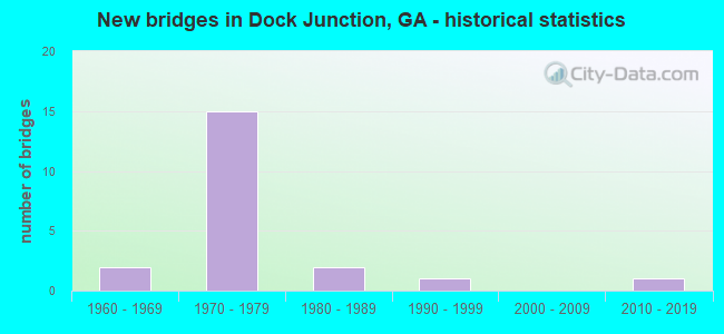
- New bridges - historical statistics
- 21960-1969
- 151970-1979
- 21980-1989
- 11990-1999
- 12010-2019

- Reconstructed bridges - Historical Statistics
- 21980-1989
- 11990-1999
- 32000-2009
- 22010-2019


- Bridge Condition - Superstructure
- 36.8%Very good
- 57.9%Good
- 5.3%Satisfactory

- Bridge Condition - Substructure
- 5.3%Very good
- 68.4%Good
- 15.8%Satisfactory
- 10.5%Fair

- Bridge Condition - Channel
- 66.7%Very good
- 33.3%Good
Find on map >> Show street view
Structure Number: 1270012, Location: 1 MI NE OF BRUNSWICK (Lat: 31.228725, Lng: -81.497286), Route carried "on" structure: Spur State highway 25, Year Built: 1976, Status: Open, Structure Length: 1.13m (3.71ft), Average Daily Traffic: 19,560 (year 2011), Truck Traffic: 1%, Average Future Daily Traffic: 29,340 (year 2031), Design Load: HS 20+Mod, Features Intersected: ALTAMAHA CANAL
Minimum Vertical Clearance: 30+ m (98+ ft), Kilometerpoint: 4.828, Lanes on structure: 4, Base Highway Network: Yes, Owner: State Highway Agency, Approaching Roadway Width: 11.6m (38.1ft), Skew: 3 degrees, Material/Design: Concrete, Design/Construction: Culvert, Number Of Spans In Main Unit: 3, Length of Maximum Span: 3.7m (12.1ft)
Condition: Channel: Good, Culverts: Good, Structural Evaluation: Better than present minimum criteria, Waterway Adequacy: Equal to present desirable criteria, Approach Roadway Alignment: Equal to present desirable criteria, Designated Inspection Frequency: Every 24 months, Inspection Date: December 2020, Bridge Improvement Cost: $223,000, Roadway Improvement Cost: $22,000, Total Project Cost: $335,000
Find on map >> Show street view
Structure Number: 1270013, Location: 5 MI N OF BRUNSWICK (Lat: 31.241578, Lng: -81.502869), Route carried "on" structure: Spur State highway 25, Year Built: 1971, Status: Open, Structure Length: 9.33m (30.61ft), Average Daily Traffic: 23,460 (year 2011), Truck Traffic: 1%, Average Future Daily Traffic: 35,190 (year 2031), Design Load: HS 20+Mod, Features Intersected: I-95 (SR 405)
Minimum Vertical Clearance: 30+ m (98+ ft), Kilometerpoint: 6.437, Lanes on structure: 2, Lanes under structure: 6, Base Highway Network: Yes, Owner: State Highway Agency, Approaching Roadway Width: 11.0m (36.1ft), Skew: 13 degrees, Material/Design: Steel continuous, Design/Construction: Stringer/Multi-beam, Number Of Spans In Main Unit: 4, Length of Maximum Span: 32.6m (107.0ft), Curb-To-Curb Width: 12.6m (41.3ft), Out-to-Out Width: 13.7m (44.9ft)
Condition: Deck: Good, Superstructure: Very good, Substructure: Good, Operating Rating: 30.8 metric tons, Method Used To Determine Operating Rating: Load Factor (LF), Inventory Rating: 18.1 metric tons, Method Used To Determine Inventory Rating: Load Factor (LF), Structural Evaluation: Meets minimum limits, Deck Geometry: Better than present minimum criteria, Underclear: Equal to present minimum criteria, Approach Roadway Alignment: Equal to present desirable criteria, Designated Inspection Frequency: Every 24 months, Inspection Date: December 2020, Bridge Improvement Cost: $1,196,000, Roadway Improvement Cost: $120,000, Total Project Cost: $1,793,000, Deck Structure Type: Concrete Cast-file-Place
Find on map >> Show street view
Structure Number: 1270014, Location: 5 MI N OF BRUNSWICK (Lat: 31.241428, Lng: -81.502994), Route carried "on" structure: Spur State highway 25, Year Built: 1971, Status: Open, Structure Length: 9.36m (30.71ft), Average Daily Traffic: 23,460 (year 2011), Truck Traffic: 1%, Average Future Daily Traffic: 35,190 (year 2031), Design Load: HS 20+Mod, Features Intersected: I-95 (SR 405)
Minimum Vertical Clearance: 30+ m (98+ ft), Kilometerpoint: 6.437, Lanes on structure: 2, Lanes under structure: 6, Base Highway Network: Yes, Owner: State Highway Agency, Approaching Roadway Width: 10.4m (34.1ft), Skew: 13 degrees, Material/Design: Steel continuous, Design/Construction: Stringer/Multi-beam, Number Of Spans In Main Unit: 4, Length of Maximum Span: 32.6m (107.0ft), Curb-To-Curb Width: 12.6m (41.3ft), Out-to-Out Width: 13.7m (44.9ft)
Condition: Deck: Good, Superstructure: Very good, Substructure: Good, Operating Rating: 21.7 metric tons, Method Used To Determine Operating Rating: Allowable Stress (AS), Inventory Rating: 18.1 metric tons, Method Used To Determine Inventory Rating: Allowable Stress (AS), Structural Evaluation: Meets minimum limits, Deck Geometry: Better than present minimum criteria, Underclear: Equal to present minimum criteria, Approach Roadway Alignment: Equal to present desirable criteria, Designated Inspection Frequency: Every 24 months, Inspection Date: December 2020, Bridge Improvement Cost: $1,200,000, Roadway Improvement Cost: $120,000, Total Project Cost: $1,799,000, Deck Structure Type: Concrete Cast-file-Place
Find on map >> Show street view
Structure Number: 1270022, Location: 3 MI S OF JCT SR 99 (Lat: 31.233822, Lng: -81.535272), Route carried "on" structure: US 25, Year Built: 1982, Status: Open, Structure Length: 4.88m (16.01ft), Average Daily Traffic: 18,570 (year 2011), Truck Traffic: 1%, Average Future Daily Traffic: 27,855 (year 2031), Design Load: HS 20+Mod, Features Intersected: BURNETT CREEK
Minimum Vertical Clearance: 30+ m (98+ ft), Kilometerpoint: 22.531, Lanes on structure: 4, Base Highway Network: Yes, Owner: State Highway Agency, Approaching Roadway Width: 20.4m (66.9ft), Material/Design: Prestressed concrete, Design/Construction: Stringer/Multi-beam, Number Of Spans In Main Unit: 4, Length of Maximum Span: 12.2m (40.0ft), Curb-To-Curb Width: 25.0m (82.0ft), Out-to-Out Width: 26.0m (85.3ft)
Condition: Deck: Good, Superstructure: Good, Substructure: Fair, Channel: Very good, Operating Rating: 82.5 metric tons, Method Used To Determine Operating Rating: Load Factor (LF), Inventory Rating: 33.5 metric tons, Method Used To Determine Inventory Rating: Load Factor (LF), Structural Evaluation: Somewhat better than minimum adequacy, Deck Geometry: Superior to present desirable criteria, Waterway Adequacy: Superior to present desirable criteria, Approach Roadway Alignment: Equal to present desirable criteria, Designated Inspection Frequency: Every 24 months, Underwater Inspection Frequency: Every 60 months, Inspection Date: October 2020, Underwater Inspection Date: May 2018, Bridge Improvement Cost: $966,000, Roadway Improvement Cost: $97,000, Total Project Cost: $1,449,000, Deck Structure Type: Concrete Cast-file-Place
Find on map >> Show street view
Structure Number: 1270023, Location: 1 MI N SR 303 & SR 27 INT (Lat: 31.215011, Lng: -81.516742), Route carried "on" structure: US 25, Year Built: 1973, Year Reconstructed: 1985, Status: Open, Structure Length: 5.18m (16.99ft), Average Daily Traffic: 23,900 (year 2011), Truck Traffic: 1%, Average Future Daily Traffic: 35,850 (year 2031), Design Load: HS 20, Features Intersected: YELLOW BLUFF CREEK
Minimum Vertical Clearance: 30+ m (98+ ft), Kilometerpoint: 25.750, Lanes on structure: 5, Base Highway Network: Yes, Owner: State Highway Agency, Approaching Roadway Width: 20.1m (65.9ft), Material/Design: Concrete, Design/Construction: Tee Beam, Number Of Spans In Main Unit: 5, Length of Maximum Span: 10.4m (34.1ft), Curb or Sidewalk Widths: Left: 1.8m (5.9ft), Right: 1.8m (5.9ft), Curb-To-Curb Width: 20.1m (65.9ft), Out-to-Out Width: 24.4m (80.1ft)
Condition: Deck: Good, Superstructure: Good, Substructure: Fair, Channel: Very good, Operating Rating: 36.2 metric tons, Method Used To Determine Operating Rating: Load Factor (LF), Inventory Rating: 21.7 metric tons, Method Used To Determine Inventory Rating: Load Factor (LF), Structural Evaluation: Somewhat better than minimum adequacy, Deck Geometry: Somewhat better than minimum adequacy, Waterway Adequacy: Equal to present desirable criteria, Approach Roadway Alignment: Equal to present desirable criteria, Designated Inspection Frequency: Every 24 months, Underwater Inspection Frequency: Every 60 months, Inspection Date: October 2020, Underwater Inspection Date: May 2018, Bridge Improvement Cost: $1,208,000, Roadway Improvement Cost: $121,000, Total Project Cost: $1,812,000, Deck Structure Type: Concrete Cast-file-Place
Find on map >> Show street view
Structure Number: 1270024, Location: .5 MI N OF BRUNSWICK (Lat: 31.187331, Lng: -81.503628), Route carried "on" structure: US 25, Year Built: 1975, Status: Open, Structure Length: 11.19m (36.71ft), Average Daily Traffic: 23,470 (year 2011), Truck Traffic: 1%, Average Future Daily Traffic: 35,205 (year 2031), Design Load: HS 20+Mod, Features Intersected: CR 13111 BLISS ST - CSX
Minimum Vertical Clearance: 30+ m (98+ ft), Kilometerpoint: 28.968, Lanes on structure: 4, Lanes under structure: 2, Base Highway Network: Yes, Owner: State Highway Agency, Approaching Roadway Width: 21.9m (71.9ft), Skew: 5 degrees, Material/Design: Steel, Design/Construction: Stringer/Multi-beam, Number Of Spans In Main Unit: 4, Length of Maximum Span: 36.6m (120.1ft), Curb or Sidewalk Widths: Left: 1.2m (3.9ft), Right: 1.2m (3.9ft), Curb-To-Curb Width: 22.2m (72.8ft), Out-to-Out Width: 25.4m (83.3ft)
Condition: Deck: Good, Superstructure: Very good, Substructure: Good, Operating Rating: 48.9 metric tons, Method Used To Determine Operating Rating: Load Factor (LF), Inventory Rating: 29.0 metric tons, Method Used To Determine Inventory Rating: Load Factor (LF), Structural Evaluation: Better than present minimum criteria, Deck Geometry: Superior to present desirable criteria, Underclear: Better than present minimum criteria, Approach Roadway Alignment: Equal to present desirable criteria, Designated Inspection Frequency: Every 24 months, Inspection Date: October 2020, Bridge Improvement Cost: $2,216,000, Roadway Improvement Cost: $222,000, Total Project Cost: $3,324,000, Deck Structure Type: Concrete Cast-file-Place
Find on map >> Show street view
Structure Number: 1270025, Location: .5 MI N OF BRUNSWICK (Lat: 31.183228, Lng: -81.503958), Route carried "on" structure: City street 623, Year Built: 1975, Status: Open, Structure Length: 7.77m (25.49ft), Average Daily Traffic: 3,750 (year 2011), Truck Traffic: 1%, Average Future Daily Traffic: 5,625 (year 2031), Design Load: HS 20+Mod, Features Intersected: SR 27 (US 25-US 341), Facility Carried by Structure: CR 592 NORWICH STR
Minimum Vertical Clearance: 30+ m (98+ ft), Kilometerpoint: 0.000, Lanes on structure: 1, Lanes under structure: 4, Base Highway Network: Yes, Owner: State Highway Agency, Approaching Roadway Width: 8.2m (26.9ft), Skew: 4 degrees, Material/Design: Steel, Design/Construction: Stringer/Multi-beam, Number Of Spans In Main Unit: 4, Length of Maximum Span: 23.8m (78.1ft), Curb or Sidewalk Widths: Left: 0.1m (0.3ft), Right: 0.1m (0.3ft), Curb-To-Curb Width: 8.2m (26.9ft), Out-to-Out Width: 9.3m (30.5ft)
Condition: Deck: Good, Superstructure: Very good, Substructure: Good, Operating Rating: 33.5 metric tons, Method Used To Determine Operating Rating: Load Factor (LF), Inventory Rating: 19.9 metric tons, Method Used To Determine Inventory Rating: Load Factor (LF), Structural Evaluation: Somewhat better than minimum adequacy, Deck Geometry: High priority of corrective action, Underclear: Equal to present minimum criteria, Approach Roadway Alignment: Equal to present desirable criteria, Designated Inspection Frequency: Every 24 months, Inspection Date: October 2020, Bridge Improvement Cost: $725,000, Roadway Improvement Cost: $72,000, Total Project Cost: $1,087,000, Deck Structure Type: Concrete Cast-file-Place
Find on map >> Show street view
Structure Number: 1270026, Location: .75 MI N OF SR 303 (Lat: 31.184939, Lng: -81.543108), Route carried "on" structure: County highway 27, Year Built: 1976, Status: Open, Structure Length: 9.91m (32.51ft), Average Daily Traffic: 420 (year 2011), Truck Traffic: 8%, Average Future Daily Traffic: 630 (year 2031), Design Load: HS 20+Mod, Features Intersected: I-95 (SR 405)
Minimum Vertical Clearance: 30+ m (98+ ft), Kilometerpoint: 1.609, Lanes on structure: 2, Lanes under structure: 6, Base Highway Network: Yes, Owner: State Highway Agency, Approaching Roadway Width: 6.7m (22.0ft), Skew: 3 degrees, Material/Design: Steel, Design/Construction: Stringer/Multi-beam, Number Of Spans In Main Unit: 4, Length of Maximum Span: 33.8m (110.9ft), Curb-To-Curb Width: 12.9m (42.3ft), Out-to-Out Width: 13.9m (45.6ft)
Condition: Deck: Good, Superstructure: Good, Substructure: Good, Operating Rating: 48.0 metric tons, Method Used To Determine Operating Rating: Load Factor (LF), Inventory Rating: 29.0 metric tons, Method Used To Determine Inventory Rating: Load Factor (LF), Structural Evaluation: Better than present minimum criteria, Deck Geometry: Superior to present desirable criteria, Underclear: Equal to present minimum criteria, Approach Roadway Alignment: Equal to present desirable criteria, Designated Inspection Frequency: Every 24 months, Inspection Date: December 2020, Bridge Improvement Cost: $1,270,000, Roadway Improvement Cost: $127,000, Total Project Cost: $1,905,000, Deck Structure Type: Concrete Cast-file-Place
Find on map >> Show street view
Structure Number: 1270042, Location: 4.4 MI N OF JCT SR 520 (Lat: 31.188358, Lng: -81.530628), Route carried "on" structure: State highway 303, Year Built: 1964, Status: Open, Structure Length: 90.46m (296.78ft), Average Daily Traffic: 10,430 (year 2011), Truck Traffic: 7%, Average Future Daily Traffic: 15,645 (year 2031), Design Load: HS 20, Features Intersected: TURTLE RIVER
Minimum Vertical Clearance: 30+ m (98+ ft), Kilometerpoint: 6.437, Lanes on structure: 2, Base Highway Network: Yes, Owner: State Highway Agency, Approaching Roadway Width: 8.8m (28.9ft), Navigation Control: Yes ( Vertical Clearance: 10.6m (34.8ft), Horizontal Clearance: 24.3m (79.7ft)), Material/Design: Steel continuous, Design/Construction: Stringer/Multi-beam, Number Of Spans In Main Unit: 3, Number Of Approach Spans: 49, Length of Maximum Span: 46.9m (153.9ft), Curb or Sidewalk Widths: Left: 0.6m (2.0ft), Right: 0.6m (2.0ft), Curb-To-Curb Width: 8.6m (28.2ft), Out-to-Out Width: 10.5m (34.4ft)
Condition: Deck: Good, Superstructure: Satisfactory, Substructure: Satisfactory, Channel: Good, Operating Rating: 49.8 metric tons, Method Used To Determine Operating Rating: Allowable Stress (AS), Inventory Rating: 31.7 metric tons, Method Used To Determine Inventory Rating: Allowable Stress (AS), Structural Evaluation: Equal to present minimum criteria, Deck Geometry: Meets minimum limits, Waterway Adequacy: Superior to present desirable criteria, Approach Roadway Alignment: Equal to present desirable criteria, Length Of Structure Improvement: 130.70m (428.81ft), Designated Inspection Frequency: Every 24 months, Underwater Inspection Frequency: Every 60 months, Inspection Date: January 2021, Underwater Inspection Date: June 2018, Bridge Improvement Cost: $11,597,000, Roadway Improvement Cost: $1,160,000, Total Project Cost: $17,395,000, Deck Structure Type: Concrete Cast-file-Place
Find on map >> Show street view
Structure Number: 1270051, Location: 2 MI S INT I-95 & SR 27 (Lat: 31.192378, Lng: -81.539989), Route carried "on" structure: Interstate 95, Year Built: 1977, Year Reconstructed: 2005, Status: Open, Structure Length: 105.10m (344.82ft), Average Daily Traffic: 46,410 (year 2011), Truck Traffic: 1%, Average Future Daily Traffic: 69,615 (year 2031), Design Load: HS 20+Mod, Features Intersected: TURTLE RIVER
Minimum Vertical Clearance: 30+ m (98+ ft), Kilometerpoint: 53.108, Lanes on structure: 6, Base Highway Network: Yes, Owner: State Highway Agency, Approaching Roadway Width: 12.8m (42.0ft), Skew: 20 degrees, Navigation Control: Yes ( Vertical Clearance: 10.6m (34.8ft), Horizontal Clearance: 24.3m (79.7ft)), Material/Design: Steel continuous, Design/Construction: Stringer/Multi-beam, Number Of Spans In Main Unit: 3, Number Of Approach Spans: 40, Length of Maximum Span: 61.0m (200.1ft), Curb-To-Curb Width: 43.3m (142.1ft), Out-to-Out Width: 46.9m (153.9ft)
Condition: Deck: Good, Superstructure: Good, Substructure: Good, Channel: Very good, Operating Rating: 66.2 metric tons, Method Used To Determine Operating Rating: Load Factor (LF), Inventory Rating: 39.9 metric tons, Method Used To Determine Inventory Rating: Load Factor (LF), Structural Evaluation: Better than present minimum criteria, Deck Geometry: Superior to present desirable criteria, Waterway Adequacy: Equal to present desirable criteria, Approach Roadway Alignment: Equal to present desirable criteria, Designated Inspection Frequency: Every 24 months, Underwater Inspection Frequency: Every 60 months, Inspection Date: November 2020, Underwater Inspection Date: June 2018, Bridge Improvement Cost: $13,472,000, Roadway Improvement Cost: $1,347,000, Total Project Cost: $20,208,000, Deck Structure Type: Concrete Cast-file-Place
Find on map >> Show street view
Structure Number: 1270053, Location: 3 MI N I-95 & SR 303 INT (Lat: 31.208250, Lng: -81.533683), Route carried "on" structure: Interstate 95, Year Built: 1976, Status: Open, Structure Length: 25.12m (82.41ft), Average Daily Traffic: 46,410 (year 2011), Truck Traffic: 1%, Average Future Daily Traffic: 69,615 (year 2031), Design Load: HS 20+Mod, Features Intersected: GIBSON CREEK
Minimum Vertical Clearance: 30+ m (98+ ft), Kilometerpoint: 56.327, Lanes on structure: 3, Base Highway Network: Yes, Owner: State Highway Agency, Approaching Roadway Width: 19.5m (64.0ft), Skew: 10 degrees, Material/Design: Prestressed concrete, Design/Construction: Stringer/Multi-beam, Number Of Spans In Main Unit: 13, Length of Maximum Span: 24.4m (80.1ft), Curb-To-Curb Width: 11.0m (36.1ft), Out-to-Out Width: 23.2m (76.1ft)
Condition: Deck: Good, Superstructure: Good, Substructure: Satisfactory, Channel: Very good, Operating Rating: 80.7 metric tons, Method Used To Determine Operating Rating: Load Factor (LF), Inventory Rating: 31.7 metric tons, Method Used To Determine Inventory Rating: Load Factor (LF), Structural Evaluation: Equal to present minimum criteria, Deck Geometry: High priority of replacement, Waterway Adequacy: Superior to present desirable criteria, Approach Roadway Alignment: Equal to present desirable criteria, Designated Inspection Frequency: Every 24 months, Underwater Inspection Frequency: Every 60 months, Inspection Date: January 2021, Underwater Inspection Date: June 2018, Bridge Improvement Cost: $4,098,000, Roadway Improvement Cost: $410,000, Total Project Cost: $6,146,000, Deck Structure Type: Concrete Cast-file-Place
Find on map >> Show street view
Structure Number: 1270054, Location: 3 MI N I-95 & SR 303 INT (Lat: 31.208294, Lng: -81.533992), Route carried "on" structure: Interstate 95, Year Built: 1976, Status: Open, Structure Length: 25.12m (82.41ft), Average Daily Traffic: 46,410 (year 2011), Truck Traffic: 1%, Average Future Daily Traffic: 69,615 (year 2031), Design Load: HS 20+Mod, Features Intersected: GIBSON CREEK
Minimum Vertical Clearance: 30+ m (98+ ft), Kilometerpoint: 56.327, Lanes on structure: 3, Base Highway Network: Yes, Owner: State Highway Agency, Approaching Roadway Width: 19.5m (64.0ft), Skew: 10 degrees, Material/Design: Prestressed concrete, Design/Construction: Stringer/Multi-beam, Number Of Spans In Main Unit: 13, Length of Maximum Span: 24.4m (80.1ft), Curb-To-Curb Width: 11.0m (36.1ft), Out-to-Out Width: 23.2m (76.1ft)
Condition: Deck: Good, Superstructure: Good, Substructure: Satisfactory, Channel: Very good, Operating Rating: 80.7 metric tons, Method Used To Determine Operating Rating: Load Factor (LF), Inventory Rating: 31.7 metric tons, Method Used To Determine Inventory Rating: Load Factor (LF), Structural Evaluation: Equal to present minimum criteria, Deck Geometry: High priority of replacement, Waterway Adequacy: Superior to present desirable criteria, Approach Roadway Alignment: Equal to present desirable criteria, Designated Inspection Frequency: Every 24 months, Underwater Inspection Frequency: Every 60 months, Inspection Date: January 2021, Underwater Inspection Date: June 2018, Bridge Improvement Cost: $4,098,000, Roadway Improvement Cost: $410,000, Total Project Cost: $6,146,000, Deck Structure Type: Concrete Cast-file-Place
Find on map >> Show street view
Structure Number: 1270055, Location: 2 MI W JCT SR 27 & SR 303 (Lat: 31.220867, Lng: -81.522392), Route carried "on" structure: Interstate 95, Year Built: 1971, Year Reconstructed: 2009, Status: Open, Structure Length: 5.64m (18.50ft), Average Daily Traffic: 46,410 (year 2011), Truck Traffic: 1%, Average Future Daily Traffic: 69,615 (year 2031), Design Load: HS 20+Mod, Features Intersected: SR 27 (US 25-US 341)
Minimum Vertical Clearance: 30+ m (98+ ft), Kilometerpoint: 57.936, Lanes on structure: 3, Lanes under structure: 6, Base Highway Network: Yes, Owner: State Highway Agency, Approaching Roadway Width: 19.5m (64.0ft), Skew: 11 degrees, Material/Design: Steel, Design/Construction: Stringer/Multi-beam, Number Of Spans In Main Unit: 4, Length of Maximum Span: 17.7m (58.1ft), Curb-To-Curb Width: 26.8m (87.9ft), Out-to-Out Width: 27.8m (91.2ft)
Condition: Deck: Good, Superstructure: Very good, Substructure: Good, Operating Rating: 49.8 metric tons, Method Used To Determine Operating Rating: Load Factor (LF), Inventory Rating: 29.9 metric tons, Method Used To Determine Inventory Rating: Load Factor (LF), Structural Evaluation: Better than present minimum criteria, Deck Geometry: Superior to present desirable criteria, Underclear: Meets minimum limits, Approach Roadway Alignment: Equal to present desirable criteria, Designated Inspection Frequency: Every 24 months, Inspection Date: November 2020, Bridge Improvement Cost: $920,000, Roadway Improvement Cost: $92,000, Total Project Cost: $1,380,000, Deck Structure Type: Concrete Cast-file-Place
Find on map >> Show street view
Structure Number: 1270056, Location: 2 MI W JCT SR 27 & SR 303 (Lat: 31.221108, Lng: -81.522628), Route carried "on" structure: Interstate 95, Year Built: 1971, Year Reconstructed: 2009, Status: Open, Structure Length: 5.64m (18.50ft), Average Daily Traffic: 46,450 (year 2011), Truck Traffic: 20%, Average Future Daily Traffic: 69,675 (year 2031), Design Load: HS 20+Mod, Features Intersected: SR 27 (US 25-US 341)
Minimum Vertical Clearance: 30+ m (98+ ft), Kilometerpoint: 57.936, Lanes on structure: 3, Lanes under structure: 6, Base Highway Network: Yes, Owner: State Highway Agency, Approaching Roadway Width: 19.5m (64.0ft), Skew: 11 degrees, Material/Design: Steel, Design/Construction: Stringer/Multi-beam, Number Of Spans In Main Unit: 4, Length of Maximum Span: 17.7m (58.1ft), Curb-To-Curb Width: 26.8m (87.9ft), Out-to-Out Width: 27.8m (91.2ft)
Condition: Deck: Good, Superstructure: Very good, Substructure: Good, Operating Rating: 49.8 metric tons, Method Used To Determine Operating Rating: Load Factor (LF), Inventory Rating: 29.9 metric tons, Method Used To Determine Inventory Rating: Load Factor (LF), Structural Evaluation: Better than present minimum criteria, Deck Geometry: Superior to present desirable criteria, Underclear: Meets minimum limits, Approach Roadway Alignment: Equal to present desirable criteria, Designated Inspection Frequency: Every 24 months, Inspection Date: November 2020, Bridge Improvement Cost: $920,000, Roadway Improvement Cost: $92,000, Total Project Cost: $1,380,000, Deck Structure Type: Concrete Cast-file-Place
Find on map >> Show street view
Structure Number: 1270057, Location: .5 MI N OF JCT SR 27 (Lat: 31.228067, Lng: -81.515506), Route carried "on" structure: Interstate 95, Year Built: 1971, Year Reconstructed: 2010, Status: Open, Structure Length: 13.05m (42.81ft), Average Daily Traffic: 46,450 (year 2011), Truck Traffic: 20%, Average Future Daily Traffic: 69,675 (year 2031), Design Load: HS 20+Mod, Features Intersected: M-621- SOU RR- SCL RR
Minimum Vertical Clearance: 30+ m (98+ ft), Kilometerpoint: 57.936, Lanes on structure: 4, Lanes under structure: 2, Base Highway Network: Yes, Owner: State Highway Agency, Approaching Roadway Width: 24.8m (81.4ft), Skew: 19 degrees, Material/Design: Steel, Design/Construction: Stringer/Multi-beam, Number Of Spans In Main Unit: 7, Length of Maximum Span: 24.4m (80.1ft), Curb-To-Curb Width: 24.2m (79.4ft), Out-to-Out Width: 24.7m (81.0ft)
Condition: Deck: Good, Superstructure: Good, Substructure: Good, Operating Rating: 31.7 metric tons, Method Used To Determine Operating Rating: Load Factor (LF), Inventory Rating: 19.0 metric tons, Method Used To Determine Inventory Rating: Load Factor (LF), Structural Evaluation: Meets minimum limits, Deck Geometry: Superior to present desirable criteria, Underclear: Better than present minimum criteria, Approach Roadway Alignment: Equal to present desirable criteria, Designated Inspection Frequency: Every 24 months, Inspection Date: December 2021, Bridge Improvement Cost: $1,672,000, Roadway Improvement Cost: $167,000, Total Project Cost: $2,508,000, Deck Structure Type: Concrete Cast-file-Place
Find on map >> Show street view
Structure Number: 1270058, Location: .5 MI N OF JCT SR 27 (Lat: 31.228228, Lng: -81.515778), Route carried "on" structure: Interstate 95, Year Built: 1971, Year Reconstructed: 2010, Status: Open, Structure Length: 11.31m (37.11ft), Average Daily Traffic: 46,450 (year 2011), Truck Traffic: 20%, Average Future Daily Traffic: 69,675 (year 2031), Design Load: HS 20+Mod, Features Intersected: M-621- SOU RR- SCL RR
Minimum Vertical Clearance: 30+ m (98+ ft), Kilometerpoint: 57.936, Lanes on structure: 4, Lanes under structure: 2, Base Highway Network: Yes, Owner: State Highway Agency, Approaching Roadway Width: 23.9m (78.4ft), Skew: 19 degrees, Material/Design: Steel, Design/Construction: Stringer/Multi-beam, Number Of Spans In Main Unit: 6, Length of Maximum Span: 21.9m (71.9ft), Curb-To-Curb Width: 23.5m (77.1ft), Out-to-Out Width: 23.9m (78.4ft)
Condition: Deck: Good, Superstructure: Good, Substructure: Good, Operating Rating: 39.0 metric tons, Method Used To Determine Operating Rating: Load Factor (LF), Inventory Rating: 22.6 metric tons, Method Used To Determine Inventory Rating: Load Factor (LF), Structural Evaluation: Somewhat better than minimum adequacy, Deck Geometry: Superior to present desirable criteria, Underclear: Better than present minimum criteria, Approach Roadway Alignment: Equal to present desirable criteria, Designated Inspection Frequency: Every 24 months, Inspection Date: December 2021, Bridge Improvement Cost: $1,450,000, Roadway Improvement Cost: $145,000, Total Project Cost: $2,174,000, Deck Structure Type: Concrete Cast-file-Place
Find on map >> Show street view
Structure Number: 1270068, Location: 1.5 MI N OF SR 303 (Lat: 31.222367, Lng: -81.504328), Route carried "on" structure: City street 621, Year Built: 1973, Year Reconstructed: 1991, Status: Open, Structure Length: 2.44m (8.01ft), Average Daily Traffic: 10,270 (year 2011), Truck Traffic: 1%, Average Future Daily Traffic: 15,405 (year 2031), Design Load: HS 20, Features Intersected: YELLOW BLUFF CREEK, Facility Carried by Structure: OLD JESUP ROAD
Minimum Vertical Clearance: 30+ m (98+ ft), Kilometerpoint: 1.609, Lanes on structure: 2, Base Highway Network: Yes, Owner: City or Municipal Highway Agency, Approaching Roadway Width: 7.6m (24.9ft), Material/Design: Prestressed concrete, Design/Construction: Box Beam or Girders - Multiple, Number Of Spans In Main Unit: 4, Length of Maximum Span: 6.1m (20.0ft), Curb-To-Curb Width: 12.4m (40.7ft), Out-to-Out Width: 13.4m (44.0ft)
Condition: Deck: Good, Superstructure: Good, Substructure: Good, Channel: Very good, Operating Rating: 51.7 metric tons, Method Used To Determine Operating Rating: Allowable Stress (AS), Inventory Rating: 32.6 metric tons, Method Used To Determine Inventory Rating: Allowable Stress (AS), Structural Evaluation: Better than present minimum criteria, Deck Geometry: Somewhat better than minimum adequacy, Waterway Adequacy: Equal to present desirable criteria, Approach Roadway Alignment: Equal to present desirable criteria, Designated Inspection Frequency: Every 24 months, Inspection Date: October 2020, Bridge Improvement Cost: $313,000, Roadway Improvement Cost: $31,000, Total Project Cost: $469,000, Deck Structure Type: Concrete Precast Panels, Wearing Surface/Protective System: Wearing Surface: Bituminous
Find on map >> Show street view
Structure Number: 1275002, Location: 3 MI NW OF BRUNSWICK (Lat: 31.241969, Lng: -81.535089), Route carried "on" structure: County highway 78, Year Built: 1965, Year Reconstructed: 2001, Status: Posted for load, Structure Length: 1.92m (6.30ft), Average Daily Traffic: 3,990 (year 2011), Truck Traffic: 1%, Average Future Daily Traffic: 5,985 (year 2031), Design Load: H 15, Features Intersected: BURNETT CREEK
Minimum Vertical Clearance: 30+ m (98+ ft), Kilometerpoint: 1.609, Lanes on structure: 2, Base Highway Network: Yes, Owner: County Highway Agency, Approaching Roadway Width: 6.1m (20.0ft), Material/Design: Concrete, Design/Construction: Slab, Number Of Spans In Main Unit: 3, Length of Maximum Span: 6.4m (21.0ft), Curb-To-Curb Width: 7.1m (23.3ft), Out-to-Out Width: 8.0m (26.2ft)
Condition: Deck: Good, Superstructure: Good, Substructure: Good, Channel: Good, Operating Rating: 34.4 metric tons, Method Used To Determine Operating Rating: Load Factor (LF), Inventory Rating: 20.8 metric tons, Method Used To Determine Inventory Rating: Load Factor (LF), Structural Evaluation: Somewhat better than minimum adequacy, Deck Geometry: High priority of replacement, Waterway Adequacy: Equal to present desirable criteria, Approach Roadway Alignment: Equal to present desirable criteria, Bridge Posting: Required (Relationship of Operating Rating to Maximum Legal Load: 10.0 - 19.9% below), Length Of Structure Improvement: 8.29m (27.20ft), Designated Inspection Frequency: Every 24 months, Inspection Date: October 2020, Bridge Improvement Cost: $246,000, Roadway Improvement Cost: $25,000, Total Project Cost: $369,000, Deck Structure Type: Concrete Precast Panels
Find on map >> Show street view
Structure Number: 1275004, Location: 2 MI S INT SR 32 & SR 27 (Lat: 31.243728, Lng: -81.572308), Route carried "on" structure: County highway 59, Year Built: 1989, Status: Open, Structure Length: 1.83m (6.00ft), Average Daily Traffic: 1,920 (year 2011), Truck Traffic: 1%, Average Future Daily Traffic: 2,880 (year 2031), Design Load: HS 20, Features Intersected: DILLARD CREEK
Minimum Vertical Clearance: 30+ m (98+ ft), Kilometerpoint: 1.609, Lanes on structure: 2, Base Highway Network: Yes, Owner: County Highway Agency, Approaching Roadway Width: 6.7m (22.0ft), Material/Design: Concrete, Design/Construction: Slab, Number Of Spans In Main Unit: 4, Length of Maximum Span: 4.6m (15.1ft), Curb-To-Curb Width: 7.4m (24.3ft), Out-to-Out Width: 8.2m (26.9ft)
Condition: Deck: Good, Superstructure: Good, Substructure: Good, Channel: Very good, Operating Rating: 41.7 metric tons, Method Used To Determine Operating Rating: Allowable Stress (AS), Inventory Rating: 29.9 metric tons, Method Used To Determine Inventory Rating: Allowable Stress (AS), Structural Evaluation: Better than present minimum criteria, Deck Geometry: Meets minimum limits, Waterway Adequacy: Superior to present desirable criteria, Approach Roadway Alignment: Equal to present desirable criteria, Designated Inspection Frequency: Every 24 months, Inspection Date: October 2020, Bridge Improvement Cost: $234,000, Roadway Improvement Cost: $23,000, Total Project Cost: $352,000, Deck Structure Type: Concrete Precast Panels
Find on map >> Show street view
Structure Number: 1275019, Location: 3.2 MI. N. OF SR 303 (Lat: 31.239169, Lng: -81.533908), Route carried "on" structure: City street 621, Year Built: 1999, Status: Open, Structure Length: 1.31m (4.30ft), Average Daily Traffic: 3,500 (year 2011), Truck Traffic: 1%, Average Future Daily Traffic: 5,250 (year 2031), Design Load: HS 20+Mod, Features Intersected: BURNETT CREEK, Facility Carried by Structure: OLD JESUP ROAD
Minimum Vertical Clearance: 30+ m (98+ ft), Kilometerpoint: 4.828, Lanes on structure: 2, Base Highway Network: Yes, Owner: City or Municipal Highway Agency, Approaching Roadway Width: 7.3m (24.0ft), Material/Design: Concrete, Design/Construction: Culvert, Number Of Spans In Main Unit: 3, Length of Maximum Span: 3.0m (9.8ft)
Condition: Channel: Good, Culverts: Good, Operating Rating: 46.2 metric tons, Method Used To Determine Operating Rating: Load Factor (LF), Inventory Rating: 28.1 metric tons, Method Used To Determine Inventory Rating: Load Factor (LF), Structural Evaluation: Better than present minimum criteria, Waterway Adequacy: Equal to present desirable criteria, Approach Roadway Alignment: Better than present minimum criteria, Designated Inspection Frequency: Every 24 months, Inspection Date: October 2020, Bridge Improvement Cost: $168,000, Roadway Improvement Cost: $17,000, Total Project Cost: $252,000
Find on map >> Show street view
Structure Number: 1275025, Location: 1MI E OF I-95, SP-25 INT (Lat: 31.247197, Lng: -81.484700), Route carried "on" structure: County highway 855, Year Built: 2017, Status: Open, Structure Length: 2.59m (8.50ft), Design Load: HS 20+Mod, Features Intersected: ALTAMAHA CANAL, Facility Carried by Structure: GLYNN CO PARKWAY
Minimum Vertical Clearance: 30+ m (98+ ft), Kilometerpoint: 1.609, Lanes on structure: 2, Base Highway Network: Yes, Owner: County Highway Agency, Approaching Roadway Width: 9.8m (32.2ft), Skew: 4 degrees, Material/Design: Prestressed concrete, Design/Construction: Stringer/Multi-beam, Number Of Spans In Main Unit: 3, Length of Maximum Span: 9.1m (29.9ft), Curb-To-Curb Width: 24.1m (79.1ft), Out-to-Out Width: 25.0m (82.0ft)
Condition: Deck: Good, Superstructure: Very good, Substructure: Very good, Channel: Very good, Operating Rating: 67.1 metric tons, Method Used To Determine Operating Rating: Load Factor (LF), Inventory Rating: 39.9 metric tons, Method Used To Determine Inventory Rating: Load Factor (LF), Structural Evaluation: Equal to present desirable criteria, Deck Geometry: Superior to present desirable criteria, Waterway Adequacy: Equal to present desirable criteria, Approach Roadway Alignment: Equal to present desirable criteria, Length Of Structure Improvement: 3.11m (10.20ft), Designated Inspection Frequency: Every 24 months, Inspection Date: November 2020, Bridge Improvement Cost: $7,548,000, Roadway Improvement Cost: $754,000, Total Project Cost: $11,322,000 ( Estimate for 2018), Deck Structure Type: Concrete Cast-file-Place
Find on map >> Show street view
Structure Number: 1270013, Location: 5 MI N OF BRUNSWICK (Lat: 31.241578, Lng: -81.502869), Route carried "under" structure: Interstate 95, Structure Length: 0. m, Average Daily Traffic: 45,650 (year 2009), Truck Traffic: 1%, Features Intersected: SR 25 SPUR NBL, Facility Carried by Structure: SR 25 SPUR NBL
Minimum Vertical Clearance: 6.04m (19.82ft), Kilometerpoint: 59.546, Lanes on structure: 2, Length of Maximum Span: 0.0m
Find on map >> Show street view
Structure Number: 1270014, Location: 5 MI N OF BRUNSWICK (Lat: 31.241428, Lng: -81.502994), Route carried "under" structure: Interstate 95, Structure Length: 0. m, Average Daily Traffic: 45,650 (year 2009), Truck Traffic: 1%, Features Intersected: SR 25 SPUR SBL, Facility Carried by Structure: SR 25 SPUR SBL
Minimum Vertical Clearance: 6.14m (20.14ft), Kilometerpoint: 59.546, Lanes on structure: 2, Length of Maximum Span: 0.0m
Find on map >> Show street view
Structure Number: 1270024, Location: .5 MI N OF BRUNSWICK (Lat: 31.187331, Lng: -81.503628), Route carried "under" structure: City street 13111, Structure Length: 0. m, Average Daily Traffic: 1,120 (year 1999), Truck Traffic: 1%, Features Intersected: SR 27 (US 25-US 341), Facility Carried by Structure: US 25 / SR27
Minimum Vertical Clearance: 6.93m (22.74ft), Kilometerpoint: 0.000, Lanes on structure: 4, Length of Maximum Span: 0.0m
Find on map >> Show street view
Structure Number: 1270025, Location: .5 MI N OF BRUNSWICK (Lat: 31.183228, Lng: -81.503958), Route carried "under" structure: US 25, Structure Length: 0. m, Average Daily Traffic: 17,260 (year 1999), Truck Traffic: 1%, Features Intersected: M-623 NORWICH STREET, Facility Carried by Structure: CR 592 NORWICH STR
Minimum Vertical Clearance: 5.79m (19.00ft), Kilometerpoint: 30.578, Lanes on structure: 1, Length of Maximum Span: 0.0m
Find on map >> Show street view
Structure Number: 1270026, Location: .75 MI N OF SR 303 (Lat: 31.184939, Lng: -81.543108), Route carried "under" structure: Interstate 95, Structure Length: 0. m, Average Daily Traffic: 40,170 (year 2009), Truck Traffic: 1%, Features Intersected: CR 27 BLYTHE ISLAND RD, Facility Carried by Structure: CR 27 BLYTHE ISLAN
Minimum Vertical Clearance: 5.96m (19.55ft), Kilometerpoint: 53.108, Lanes on structure: 2, Length of Maximum Span: 0.0m
Find on map >> Show street view
Structure Number: 1270055, Location: 2 MI W JCT SR 27 & SR 303 (Lat: 31.220867, Lng: -81.522392), Route carried "under" structure: US 25, Structure Length: 0. m, Average Daily Traffic: 21,560 (year 1999), Truck Traffic: 1%, Features Intersected: I-95 NBL (SR 405), Facility Carried by Structure: I-95 NBL
Minimum Vertical Clearance: 5.35m (17.55ft), Kilometerpoint: 25.750, Lanes on structure: 3, Length of Maximum Span: 0.0m
Find on map >> Show street view
Structure Number: 1270056, Location: 2 MI W JCT SR 27 & SR 303 (Lat: 31.221108, Lng: -81.522628), Route carried "under" structure: US 25, Structure Length: 0. m, Average Daily Traffic: 21,560 (year 1999), Truck Traffic: 1%, Features Intersected: I-95 SBL (SR 405), Facility Carried by Structure: I-95 SBL
Minimum Vertical Clearance: 5.18m (16.99ft), Kilometerpoint: 25.750, Lanes on structure: 3, Length of Maximum Span: 0.0m
Find on map >> Show street view
Structure Number: 1270057, Location: .5 MI N OF JCT SR 27 (Lat: 31.228067, Lng: -81.515506), Route carried "under" structure: City street 621, Structure Length: 0. m, Average Daily Traffic: 7,210 (year 1999), Truck Traffic: 1%, Features Intersected: I-95 NBL (SR 405), Facility Carried by Structure: I-95 NBL
Minimum Vertical Clearance: 7.54m (24.74ft), Kilometerpoint: 3.219, Lanes on structure: 2, Length of Maximum Span: 0.0m
Find on map >> Show street view
Structure Number: 1270058, Location: .5 MI N OF JCT SR 27 (Lat: 31.228228, Lng: -81.515778), Route carried "under" structure: City street 621, Structure Length: 0. m, Average Daily Traffic: 7,210 (year 1999), Truck Traffic: 1%, Features Intersected: I-95 SBL (SR 405), Facility Carried by Structure: I-95 SBL
Minimum Vertical Clearance: 7.26m (23.82ft), Kilometerpoint: 3.219, Lanes on structure: 2, Length of Maximum Span: 0.0m