Bridge Statistics for Diamond Bar, California (CA)
Condition, Traffic, Stress, Structural Evaluation, Project Costs
- National Bridge Inventory (NBI) Statistics
- 47Number of bridges
- 1,050ft / 320mTotal length
- 4,637,927Total average daily traffic
- 335,259Total average daily truck traffic
- National Bridge Inventory (NBI) Registered Bridges for Diamond Bar
- No street view available for this location
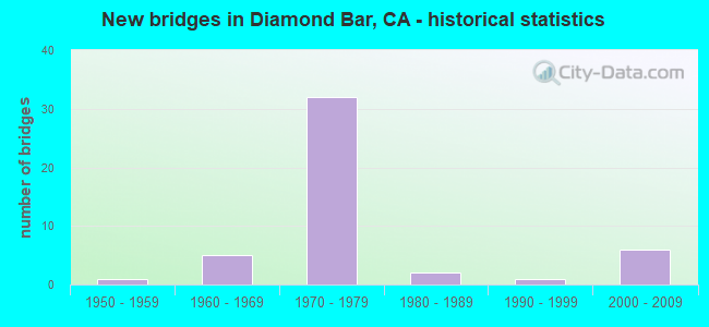
- New bridges - historical statistics
- 11950-1959
- 51960-1969
- 321970-1979
- 21980-1989
- 11990-1999
- 62000-2009

- Reconstructed bridges - Historical Statistics
- 21970-1979
- 11980-1989
- 51990-1999
- 12000-2009


- Bridge Condition - Deck
- 62.5%Good
- 4.2%Satisfactory
- 29.2%Fair
- 4.2%Poor

- Bridge Condition - Superstructure
- 79.2%Good
- 20.8%Fair
Find on map >> Show street view
Structure Number: 53 1787, Location: 07-LA-060-R22.38-DMBR (Lat: 33.998572, Lng: -117.855147), Route carried "on" structure: State highway 60, Year Built: 1970, Status: Open, Structure Length: 4.45m (14.60ft), Average Daily Traffic: 204,000 (year 2015), Average Future Daily Traffic: 256,822 (year 2040), Design Load: HS 20, Features Intersected: LEMON AVE
Minimum Vertical Clearance: 30+ m (98+ ft), Kilometerpoint: 22.380, Lanes on structure: 8, Lanes under structure: 4, Base Highway Network: Yes (, Subroute: 1), Owner: State Highway Agency, Approaching Roadway Width: 40.2m (131.9ft), Skew: 30 degrees, Material/Design: Prestressed concrete, Design/Construction: Box Beam or Girders - Multiple, Number Of Spans In Main Unit: 1, Length of Maximum Span: 43.9m (144.0ft), Curb-To-Curb Width: 40.2m (131.9ft), Out-to-Out Width: 41.5m (136.2ft)
Condition: Deck: Good, Superstructure: Good, Substructure: Good, Operating Rating: 57.0 metric tons, Method Used To Determine Operating Rating: Load and Resistance Factor Rating (LRFR) rating reported by rating factor(RF) method using HL-93 loadings, Inventory Rating: 34.0 metric tons, Method Used To Determine Inventory Rating: Load and Resistance Factor Rating (LRFR) rating reported by rating factor(RF) method using HL-93 loadings, Structural Evaluation: Better than present minimum criteria, Deck Geometry: Superior to present desirable criteria, Underclear: Meets minimum limits, Approach Roadway Alignment: Superior to present desirable criteria, Designated Inspection Frequency: Every 24 months, Inspection Date: Febuary 2021, Deck Structure Type: Concrete Cast-file-Place
Find on map >> Show street view
Structure Number: 53 1845, Location: 07-LA-060-R22.97-DMBR (Lat: 34.000378, Lng: -117.844953), Route carried "on" structure: State highway 60, Year Built: 1970, Status: Open, Structure Length: 4.69m (15.39ft), Average Daily Traffic: 208,000 (year 2015), Truck Traffic: 10%, Average Future Daily Traffic: 226,670 (year 2040), Design Load: HS 20, Features Intersected: OLD BREA CYN RD
Minimum Vertical Clearance: 30+ m (98+ ft), Kilometerpoint: 22.970, Lanes on structure: 10, Lanes under structure: 4, Base Highway Network: Yes (, Subroute: 1), Owner: State Highway Agency, Approaching Roadway Width: 48.5m (159.1ft), Skew: 31 degrees, Material/Design: Concrete continuous, Design/Construction: Box Beam or Girders - Multiple, Number Of Spans In Main Unit: 2, Length of Maximum Span: 23.2m (76.1ft), Curb-To-Curb Width: 48.7m (159.8ft), Out-to-Out Width: 49.9m (163.7ft)
Condition: Deck: Fair, Superstructure: Good, Substructure: Good, Operating Rating: 64.8 metric tons, Method Used To Determine Operating Rating: Load and Resistance Factor Rating (LRFR) rating reported by rating factor(RF) method using HL-93 loadings, Inventory Rating: 47.0 metric tons, Method Used To Determine Inventory Rating: Load and Resistance Factor Rating (LRFR) rating reported by rating factor(RF) method using HL-93 loadings, Structural Evaluation: Better than present minimum criteria, Deck Geometry: Superior to present desirable criteria, Underclear: Meets minimum limits, Approach Roadway Alignment: Superior to present desirable criteria, Designated Inspection Frequency: Every 24 months, Inspection Date: Febuary 2021, Deck Structure Type: Concrete Cast-file-Place
Find on map >> Show street view
Structure Number: 53 1846G, Location: 07-LA-060-R23.31-DMBR (Lat: 34.001086, Lng: -117.839306), Route carried "on" structure: Ramp State highway 60, Year Built: 1972, Status: Open, Structure Length: 12.89m (42.29ft), Average Daily Traffic: 22,800 (year 2015), Truck Traffic: 8%, Average Future Daily Traffic: 41,268 (year 2040), Design Load: HS 20+Mod, Features Intersected: GOLDEN SPRINGS DRIVE
Minimum Vertical Clearance: 30+ m (98+ ft), Kilometerpoint: 23.310, Lanes on structure: 2, Lanes under structure: 4, Base Highway Network: Yes (, Subroute: 1), Owner: State Highway Agency, Approaching Roadway Width: 9.8m (32.2ft), Material/Design: Prestressed concrete continuous, Design/Construction: Box Beam or Girders - Multiple, Number Of Spans In Main Unit: 2, Number Of Approach Spans: 1, Length of Maximum Span: 54.9m (180.1ft), Curb-To-Curb Width: 9.8m (32.2ft), Out-to-Out Width: 10.4m (34.1ft)
Condition: Deck: Good, Superstructure: Good, Substructure: Good, Operating Rating: 64.5 metric tons, Method Used To Determine Operating Rating: Load Factor (LF), Inventory Rating: 32.4 metric tons, Method Used To Determine Inventory Rating: Load Factor (LF), Structural Evaluation: Better than present minimum criteria, Deck Geometry: Equal to present minimum criteria, Underclear: Somewhat better than minimum adequacy, Approach Roadway Alignment: Superior to present desirable criteria, Designated Inspection Frequency: Every 24 months, Inspection Date: Febuary 2021, Deck Structure Type: Concrete Cast-file-Place
Find on map >> Show street view
Structure Number: 53 1848G, Location: 07-LA-057-R4.32R-DMBR (Lat: 33.998911, Lng: -117.837133), Route carried "on" structure: Ramp State highway 57, Year Built: 1972, Status: Open, Structure Length: 44.84m (147.11ft), Average Daily Traffic: 26,000 (year 2011), Truck Traffic: 2%, Average Future Daily Traffic: 31,427 (year 2040), Design Load: HS 20, Features Intersected: SR 57,SR 60,GLDN SPR DRN
Minimum Vertical Clearance: 30+ m (98+ ft), Kilometerpoint: 4.320, Lanes on structure: 2, Lanes under structure: 21, Base Highway Network: Yes (, Subroute: 1), Owner: State Highway Agency, Approaching Roadway Width: 9.8m (32.2ft), Skew: 9 degrees, Material/Design: Prestressed concrete continuous, Design/Construction: Box Beam or Girders - Multiple, Number Of Spans In Main Unit: 6, Number Of Approach Spans: 6, Length of Maximum Span: 53.3m (174.9ft), Curb-To-Curb Width: 9.8m (32.2ft), Out-to-Out Width: 10.4m (34.1ft)
Condition: Deck: Good, Superstructure: Good, Substructure: Good, Operating Rating: 99.8 metric tons, Method Used To Determine Operating Rating: Load Factor (LF), Inventory Rating: 32.4 metric tons, Method Used To Determine Inventory Rating: Load Factor (LF), Structural Evaluation: Better than present minimum criteria, Deck Geometry: Equal to present minimum criteria, Underclear: Meets minimum limits, Approach Roadway Alignment: Meets minimum limits, Designated Inspection Frequency: Every 24 months, Inspection Date: August 2020, Deck Structure Type: Concrete Cast-file-Place
Find on map >> Show street view
Structure Number: 53 1864, Location: 07-LA-060-R24.45-DMBR (Lat: 34.010478, Lng: -117.823550), Route carried "on" structure: County highway L381, Year Built: 1970, Status: Open, Structure Length: 9.42m (30.91ft), Average Daily Traffic: 24,150 (year 2015), Truck Traffic: 4%, Average Future Daily Traffic: 32,171 (year 2041), Design Load: HS 20+Mod, Features Intersected: STATE ROUTE 60, Facility Carried by Structure: GRAND AVE
Minimum Vertical Clearance: 30+ m (98+ ft), Kilometerpoint: 0.000, Lanes on structure: 6, Lanes under structure: 17, Owner: State Highway Agency, Approaching Roadway Width: 24.5m (80.4ft), Skew: 23 degrees, Material/Design: Prestressed concrete continuous, Design/Construction: Box Beam or Girders - Multiple, Number Of Spans In Main Unit: 2, Length of Maximum Span: 48.2m (158.1ft), Curb or Sidewalk Widths: Left: 1.5m (4.9ft), Right: 1.5m (4.9ft), Curb-To-Curb Width: 24.5m (80.4ft), Out-to-Out Width: 28.1m (92.2ft)
Condition: Deck: Fair, Superstructure: Good, Substructure: Good, Operating Rating: 52.2 metric tons, Method Used To Determine Operating Rating: Load and Resistance Factor Rating (LRFR) rating reported by rating factor(RF) method using HL-93 loadings, Inventory Rating: 39.5 metric tons, Method Used To Determine Inventory Rating: Load and Resistance Factor Rating (LRFR) rating reported by rating factor(RF) method using HL-93 loadings, Structural Evaluation: Better than present minimum criteria, Deck Geometry: Somewhat better than minimum adequacy, Underclear: High priority of corrective action, Approach Roadway Alignment: Equal to present desirable criteria, Designated Inspection Frequency: Every 24 months, Inspection Date: January 2021, Deck Structure Type: Concrete Cast-file-Place
Find on map >> Show street view
Structure Number: 53 1873, Location: 07-LA-060-R25.36-DMBR (Lat: 34.020772, Lng: -117.814178), Route carried "on" structure: State highway 60, Year Built: 1970, Status: Open, Structure Length: 4.05m (13.29ft), Average Daily Traffic: 339,000 (year 2015), Truck Traffic: 8%, Average Future Daily Traffic: 390,280 (year 2040), Design Load: HS 20+Mod, Features Intersected: PROSPECTORS ROAD
Minimum Vertical Clearance: 30+ m (98+ ft), Kilometerpoint: 25.360, Lanes on structure: 11, Lanes under structure: 2, Base Highway Network: Yes (, Subroute: 1), Owner: State Highway Agency, Approaching Roadway Width: 56.1m (184.1ft), Skew: 39 degrees, Material/Design: Concrete continuous, Design/Construction: Box Beam or Girders - Multiple, Number Of Spans In Main Unit: 3, Length of Maximum Span: 20.7m (67.9ft), Curb-To-Curb Width: 56.2m (184.4ft), Out-to-Out Width: 57.5m (188.6ft)
Condition: Deck: Poor, Superstructure: Good, Substructure: Good, Operating Rating: 83.9 metric tons, Method Used To Determine Operating Rating: Load Factor (LF), Inventory Rating: 50.5 metric tons, Method Used To Determine Inventory Rating: Load Factor (LF), Structural Evaluation: Better than present minimum criteria, Deck Geometry: Superior to present desirable criteria, Underclear: Equal to present desirable criteria, Approach Roadway Alignment: Equal to present desirable criteria, Designated Inspection Frequency: Every 24 months, Inspection Date: January 2021, Deck Structure Type: Concrete Cast-file-Place
Find on map >> Show street view
Structure Number: 53 1873G, Location: 07-LA-060-R25.36-DMBR (Lat: 34.020425, Lng: -117.814019), Route carried "on" structure: Ramp State highway 60, Year Built: 1970, Status: Open, Structure Length: 4.69m (15.39ft), Average Daily Traffic: 71,400 (year 2015), Truck Traffic: 10%, Average Future Daily Traffic: 108,495 (year 2041), Design Load: HS 20+Mod, Features Intersected: PROSPECTORS ROAD
Minimum Vertical Clearance: 30+ m (98+ ft), Kilometerpoint: 25.360, Lanes on structure: 3, Lanes under structure: 2, Base Highway Network: Yes (, Subroute: 1), Owner: State Highway Agency, Approaching Roadway Width: 15.0m (49.2ft), Skew: 9 degrees, Material/Design: Concrete continuous, Design/Construction: Box Beam or Girders - Multiple, Number Of Spans In Main Unit: 3, Length of Maximum Span: 24.4m (80.1ft), Curb-To-Curb Width: 15.0m (49.2ft), Out-to-Out Width: 15.9m (52.2ft)
Condition: Deck: Fair, Superstructure: Good, Substructure: Good, Operating Rating: 36.0 metric tons, Method Used To Determine Operating Rating: Load and Resistance Factor Rating (LRFR) rating reported by rating factor(RF) method using HL-93 loadings, Inventory Rating: 27.5 metric tons, Method Used To Determine Inventory Rating: Load and Resistance Factor Rating (LRFR) rating reported by rating factor(RF) method using HL-93 loadings, Structural Evaluation: Equal to present minimum criteria, Deck Geometry: Superior to present desirable criteria, Underclear: Superior to present desirable criteria, Approach Roadway Alignment: Superior to present desirable criteria, Designated Inspection Frequency: Every 24 months, Inspection Date: January 2021, Deck Structure Type: Concrete Cast-file-Place
Find on map >> Show street view
Structure Number: 53 189, Location: 07-LA-210-R32.08-ADA (Lat: 34.146406, Lng: -118.028744), Route carried "on" structure: Interstate 210, Year Built: 1968, Year Reconstructed: 2011, Status: Open, Structure Length: 5.43m (17.81ft), Average Daily Traffic: 252,000 (year 2012), Truck Traffic: 7%, Average Future Daily Traffic: 270,961 (year 2042), Design Load: HS 20, Features Intersected: FIRST AVENUE
Minimum Vertical Clearance: 30+ m (98+ ft), Kilometerpoint: 32.080, Lanes on structure: 13, Lanes under structure: 2, Base Highway Network: Yes (Inventory Route: 2, Subroute: 1), Owner: State Highway Agency, Approaching Roadway Width: 52.4m (171.9ft), Skew: 23 degrees, Material/Design: Concrete continuous, Design/Construction: Box Beam or Girders - Multiple, Number Of Spans In Main Unit: 3, Length of Maximum Span: 29.6m (97.1ft), Curb-To-Curb Width: 55.5m (182.1ft), Out-to-Out Width: 55.5m (182.1ft)
Condition: Deck: Good, Superstructure: Good, Substructure: Good, Operating Rating: 81.3 metric tons, Method Used To Determine Operating Rating: Load Factor (LF), Inventory Rating: 48.9 metric tons, Method Used To Determine Inventory Rating: Load Factor (LF), Structural Evaluation: Better than present minimum criteria, Deck Geometry: Superior to present desirable criteria, Underclear: Somewhat better than minimum adequacy, Approach Roadway Alignment: Superior to present desirable criteria, Designated Inspection Frequency: Every 24 months, Inspection Date: May 2021, Deck Structure Type: Concrete Cast-file-Place
Find on map >> Show street view
Structure Number: 53 1899, Location: 07-LA-060-R25.56-DMBR (Lat: 34.022997, Lng: -117.811775), Route carried "on" structure: State highway 60, Year Built: 1970, Status: Open, Structure Length: 4.75m (15.58ft), Average Daily Traffic: 223,000 (year 2015), Truck Traffic: 11%, Average Future Daily Traffic: 339,370 (year 2040), Design Load: HS 20, Features Intersected: DIAMOND BAR
Minimum Vertical Clearance: 30+ m (98+ ft), Kilometerpoint: 25.560, Lanes on structure: 11, Lanes under structure: 5, Base Highway Network: Yes (, Subroute: 1), Owner: State Highway Agency, Approaching Roadway Width: 43.9m (144.0ft), Skew: 39 degrees, Material/Design: Prestressed concrete, Design/Construction: Box Beam or Girders - Multiple, Number Of Spans In Main Unit: 1, Length of Maximum Span: 47.2m (154.9ft), Curb-To-Curb Width: 43.9m (144.0ft), Out-to-Out Width: 45.1m (148.0ft)
Condition: Deck: Fair, Superstructure: Good, Substructure: Good, Operating Rating: 64.2 metric tons, Method Used To Determine Operating Rating: Load and Resistance Factor Rating (LRFR) rating reported by rating factor(RF) method using HL-93 loadings, Inventory Rating: 38.9 metric tons, Method Used To Determine Inventory Rating: Load and Resistance Factor Rating (LRFR) rating reported by rating factor(RF) method using HL-93 loadings, Structural Evaluation: Better than present minimum criteria, Deck Geometry: Meets minimum limits, Underclear: Meets minimum limits, Approach Roadway Alignment: Equal to present desirable criteria, Designated Inspection Frequency: Every 24 months, Inspection Date: Febuary 2021, Deck Structure Type: Concrete Cast-file-Place
Find on map >> Show street view
Structure Number: 53 1905, Location: 07-LA-060-R25.45-DMBR (Lat: 34.021281, Lng: -117.813675), Route carried "on" structure: State highway 60, Year Built: 1970, Status: Open, Structure Length: 5.27m (17.29ft), Average Daily Traffic: 339,000 (year 2015), Truck Traffic: 8%, Average Future Daily Traffic: 339,370 (year 2038), Design Load: HS 20, Features Intersected: E60-N57 CONNECTOR RAMP
Minimum Vertical Clearance: 30+ m (98+ ft), Kilometerpoint: 25.450, Lanes on structure: 9, Lanes under structure: 3, Base Highway Network: Yes (, Subroute: 1), Owner: State Highway Agency, Approaching Roadway Width: 47.9m (157.2ft), Skew: 39 degrees, Material/Design: Concrete, Design/Construction: Box Beam or Girders - Multiple, Number Of Spans In Main Unit: 1, Length of Maximum Span: 51.8m (169.9ft), Curb-To-Curb Width: 48.1m (157.8ft), Out-to-Out Width: 49.3m (161.7ft)
Condition: Deck: Fair, Superstructure: Fair, Substructure: Good, Operating Rating: 79.7 metric tons, Method Used To Determine Operating Rating: Load Factor (LF), Inventory Rating: 48.0 metric tons, Method Used To Determine Inventory Rating: Load Factor (LF), Structural Evaluation: Somewhat better than minimum adequacy, Deck Geometry: Superior to present desirable criteria, Underclear: Somewhat better than minimum adequacy, Approach Roadway Alignment: Superior to present desirable criteria, Designated Inspection Frequency: Every 24 months, Inspection Date: January 2021, Deck Structure Type: Concrete Cast-file-Place
Find on map >> Show street view
Structure Number: 53 1941, Location: 07-LA-057-4.98-DMBR (Lat: 34.028569, Lng: -117.811219), Route carried "on" structure: State highway 57, Year Built: 1970, Status: Open, Structure Length: 4.60m (15.09ft), Average Daily Traffic: 145,000 (year 2012), Average Future Daily Traffic: 143,308 (year 2040), Design Load: HS 20, Features Intersected: SUNSET CROSSING RD
Minimum Vertical Clearance: 30+ m (98+ ft), Kilometerpoint: 4.980, Lanes on structure: 10, Lanes under structure: 5, Base Highway Network: Yes (, Subroute: 1), Owner: State Highway Agency, Approaching Roadway Width: 48.2m (158.1ft), Skew: 30 degrees, Material/Design: Prestressed concrete, Design/Construction: Box Beam or Girders - Multiple, Number Of Spans In Main Unit: 1, Length of Maximum Span: 45.4m (149.0ft), Curb-To-Curb Width: 47.5m (155.8ft), Out-to-Out Width: 48.8m (160.1ft)
Condition: Deck: Good, Superstructure: Fair, Substructure: Good, Operating Rating: 58.3 metric tons, Method Used To Determine Operating Rating: Load and Resistance Factor Rating (LRFR) rating reported by rating factor(RF) method using HL-93 loadings, Inventory Rating: 36.3 metric tons, Method Used To Determine Inventory Rating: Load and Resistance Factor Rating (LRFR) rating reported by rating factor(RF) method using HL-93 loadings, Structural Evaluation: Somewhat better than minimum adequacy, Deck Geometry: Superior to present desirable criteria, Underclear: Equal to present minimum criteria, Approach Roadway Alignment: Equal to present desirable criteria, Designated Inspection Frequency: Every 24 months, Inspection Date: August 2020, Deck Structure Type: Concrete Cast-file-Place
Find on map >> Show street view
Structure Number: 53 207, Location: 07-LA-014-R27.04 (Lat: 34.364869, Lng: -118.503414), Route carried "on" structure: State highway 14, Year Built: 1971, Year Reconstructed: 1998, Status: Open, Structure Length: 4.63m (15.19ft), Average Daily Traffic: 148,000 (year 2021), Truck Traffic: 4%, Average Future Daily Traffic: 234,766 (year 2041), Design Load: HS 20, Features Intersected: NEWHALL AVENUE
Minimum Vertical Clearance: 30+ m (98+ ft), Kilometerpoint: 27.040, Lanes on structure: 10, Lanes under structure: 6, Base Highway Network: Yes (, Subroute: 1), Owner: State Highway Agency, Approaching Roadway Width: 45.7m (149.9ft), Material/Design: Prestressed concrete, Design/Construction: Box Beam or Girders - Multiple, Number Of Spans In Main Unit: 1, Length of Maximum Span: 45.8m (150.3ft), Curb-To-Curb Width: 45.7m (149.9ft), Out-to-Out Width: 46.9m (153.9ft)
Condition: Deck: Satisfactory, Superstructure: Good, Substructure: Good, Operating Rating: 59.3 metric tons, Method Used To Determine Operating Rating: Load and Resistance Factor Rating (LRFR) rating reported by rating factor(RF) method using HL-93 loadings, Inventory Rating: 35.6 metric tons, Method Used To Determine Inventory Rating: Load and Resistance Factor Rating (LRFR) rating reported by rating factor(RF) method using HL-93 loadings, Structural Evaluation: Better than present minimum criteria, Deck Geometry: Superior to present desirable criteria, Underclear: Somewhat better than minimum adequacy, Approach Roadway Alignment: Equal to present desirable criteria, Designated Inspection Frequency: Every 24 months, Inspection Date: January 2021, Deck Structure Type: Concrete Cast-file-Place
Find on map >> Show street view
Structure Number: 53 2079, Location: 07-LA-060-R26.53-DMBR (Lat: 34.027556, Lng: -117.796353), Route carried "on" structure: State highway 60, Year Built: 1970, Year Reconstructed: 1995, Status: Open, Structure Length: 4.22m (13.85ft), Average Daily Traffic: 213,000 (year 2015), Truck Traffic: 12%, Average Future Daily Traffic: 270,252 (year 2040), Design Load: HS 20, Features Intersected: GOLDEN SPRINGS DR
Minimum Vertical Clearance: 30+ m (98+ ft), Kilometerpoint: 26.530, Lanes on structure: 11, Lanes under structure: 4, Base Highway Network: Yes (, Subroute: 1), Owner: State Highway Agency, Approaching Roadway Width: 45.2m (148.3ft), Skew: 39 degrees, Material/Design: Prestressed concrete, Design/Construction: Box Beam or Girders - Multiple, Number Of Spans In Main Unit: 1, Length of Maximum Span: 41.5m (136.2ft), Curb-To-Curb Width: 45.2m (148.3ft), Out-to-Out Width: 46.3m (151.9ft)
Condition: Deck: Good, Superstructure: Good, Substructure: Good, Operating Rating: 52.2 metric tons, Method Used To Determine Operating Rating: Load and Resistance Factor Rating (LRFR) rating reported by rating factor(RF) method using HL-93 loadings, Inventory Rating: 29.2 metric tons, Method Used To Determine Inventory Rating: Load and Resistance Factor Rating (LRFR) rating reported by rating factor(RF) method using HL-93 loadings, Structural Evaluation: Better than present minimum criteria, Deck Geometry: Somewhat better than minimum adequacy, Underclear: Meets minimum limits, Approach Roadway Alignment: Equal to present desirable criteria, Designated Inspection Frequency: Every 24 months, Inspection Date: Febuary 2021, Deck Structure Type: Concrete Cast-file-Place
Find on map >> Show street view
Structure Number: 53 214, Location: 07-LA-134-R11.68-LA (Lat: 34.142181, Lng: -118.182256), Route carried "on" structure: City street , Year Built: 1971, Status: Open, Structure Length: 12.68m (41.60ft), Average Daily Traffic: 1,100 (year 2010), Truck Traffic: 2%, Average Future Daily Traffic: 1,302 (year 2042), Design Load: HS 20, Features Intersected: ST RTE 134 & OFF-RAMP, Facility Carried by Structure: PATRICIAN WAY
Minimum Vertical Clearance: 30+ m (98+ ft), Kilometerpoint: 0.000, Lanes on structure: 2, Lanes under structure: 13, Owner: State Highway Agency, Approaching Roadway Width: 12.2m (40.0ft), Skew: 3 degrees, Material/Design: Prestressed concrete continuous, Design/Construction: Box Beam or Girders - Multiple, Number Of Spans In Main Unit: 3, Length of Maximum Span: 47.1m (154.5ft), Curb or Sidewalk Widths: Left: 2.1m (6.9ft), Right: 2.1m (6.9ft), Curb-To-Curb Width: 12.2m (40.0ft), Out-to-Out Width: 17.1m (56.1ft)
Condition: Deck: Good, Superstructure: Good, Substructure: Good, Operating Rating: 52.2 metric tons, Method Used To Determine Operating Rating: Load and Resistance Factor Rating (LRFR) rating reported by rating factor(RF) method using HL-93 loadings, Inventory Rating: 39.9 metric tons, Method Used To Determine Inventory Rating: Load and Resistance Factor Rating (LRFR) rating reported by rating factor(RF) method using HL-93 loadings, Structural Evaluation: Better than present minimum criteria, Deck Geometry: Better than present minimum criteria, Underclear: High priority of corrective action, Approach Roadway Alignment: Equal to present desirable criteria, Designated Inspection Frequency: Every 24 months, Inspection Date: Febuary 2020, Deck Structure Type: Concrete Cast-file-Place
Find on map >> Show street view
Structure Number: 53 2149R, Location: 07-LA-057-R4.49R-DMBR (Lat: 34.001250, Lng: -117.834606), Route carried "on" structure: State highway 57, Year Built: 1972, Status: Open, Structure Length: 9.81m (32.19ft), Average Daily Traffic: 99,000 (year 2012), Truck Traffic: 8%, Average Future Daily Traffic: 116,766 (year 2040), Design Load: HS 20, Features Intersected: GOLDEN SPRINGS DR
Minimum Vertical Clearance: 30+ m (98+ ft), Kilometerpoint: 4.490, Lanes on structure: 3, Lanes under structure: 4, Base Highway Network: Yes (, Subroute: 1), Owner: State Highway Agency, Approaching Roadway Width: 16.5m (54.1ft), Skew: 6 degrees, Material/Design: Prestressed concrete continuous, Design/Construction: Box Beam or Girders - Multiple, Number Of Spans In Main Unit: 2, Length of Maximum Span: 48.8m (160.1ft), Curb-To-Curb Width: 16.5m (54.1ft), Out-to-Out Width: 17.1m (56.1ft)
Condition: Deck: Good, Superstructure: Good, Substructure: Good, Operating Rating: 23.7 metric tons, Method Used To Determine Operating Rating: Load and Resistance Factor Rating (LRFR) rating reported by rating factor(RF) method using HL-93 loadings, Inventory Rating: 17.8 metric tons, Method Used To Determine Inventory Rating: Load and Resistance Factor Rating (LRFR) rating reported by rating factor(RF) method using HL-93 loadings, Structural Evaluation: Meets minimum limits, Deck Geometry: Equal to present minimum criteria, Underclear: Somewhat better than minimum adequacy, Approach Roadway Alignment: Equal to present desirable criteria, Designated Inspection Frequency: Every 24 months, Inspection Date: August 2020, Deck Structure Type: Concrete Cast-file-Place
Find on map >> Show street view
Structure Number: 53 2161, Location: 07-LA-057-R0.91-DMBR (Lat: 33.957489, Lng: -117.860025), Route carried "on" structure: State highway 57, Year Built: 1972, Year Reconstructed: 1998, Status: Open, Structure Length: 10.42m (34.19ft), Average Daily Traffic: 203,000 (year 2012), Truck Traffic: 8%, Average Future Daily Traffic: 244,193 (year 2040), Design Load: HS 20, Features Intersected: BREA CANYON RD
Minimum Vertical Clearance: 30+ m (98+ ft), Kilometerpoint: 0.910, Lanes on structure: 10, Lanes under structure: 4, Base Highway Network: Yes (, Subroute: 1), Owner: State Highway Agency, Approaching Roadway Width: 42.1m (138.1ft), Skew: 36 degrees, Material/Design: Prestressed concrete continuous, Design/Construction: Box Beam or Girders - Multiple, Number Of Spans In Main Unit: 2, Length of Maximum Span: 56.4m (185.0ft), Curb or Sidewalk Widths: Left: 0.3m (1.0ft), Right: 0.3m (1.0ft), Curb-To-Curb Width: 41.5m (136.2ft), Out-to-Out Width: 49.1m (161.1ft)
Condition: Deck: Good, Superstructure: Good, Substructure: Good, Operating Rating: 54.1 metric tons, Method Used To Determine Operating Rating: Field evaluation and documented engineering judgment, Inventory Rating: 32.4 metric tons, Method Used To Determine Inventory Rating: Field evaluation and documented engineering judgment, Structural Evaluation: Better than present minimum criteria, Deck Geometry: Equal to present minimum criteria, Underclear: Equal to present minimum criteria, Approach Roadway Alignment: Better than present minimum criteria, Designated Inspection Frequency: Every 24 months, Inspection Date: August 2020, Deck Structure Type: Concrete Cast-file-Place
Find on map >> Show street view
Structure Number: 53 2162, Location: 07-LA-057-R1.94-DMBR (Lat: 33.968144, Lng: -117.848897), Route carried "on" structure: State highway 57, Year Built: 1972, Year Reconstructed: 1998, Status: Open, Structure Length: 4.75m (15.58ft), Average Daily Traffic: 198,000 (year 2012), Truck Traffic: 8%, Average Future Daily Traffic: 233,532 (year 2040), Design Load: HS 20, Features Intersected: DIAMOND BAR BLVD
Minimum Vertical Clearance: 30+ m (98+ ft), Kilometerpoint: 1.940, Lanes on structure: 10, Lanes under structure: 5, Base Highway Network: Yes (, Subroute: 1), Owner: State Highway Agency, Approaching Roadway Width: 42.1m (138.1ft), Skew: 30 degrees, Material/Design: Prestressed concrete, Design/Construction: Box Beam or Girders - Multiple, Number Of Spans In Main Unit: 1, Length of Maximum Span: 46.9m (153.9ft), Curb or Sidewalk Widths: Left: 0.3m (1.0ft), Right: 0.3m (1.0ft), Curb-To-Curb Width: 41.5m (136.2ft), Out-to-Out Width: 49.1m (161.1ft)
Condition: Deck: Good, Superstructure: Fair, Substructure: Good, Operating Rating: 49.9 metric tons, Method Used To Determine Operating Rating: Load and Resistance Factor Rating (LRFR) rating reported by rating factor(RF) method using HL-93 loadings, Inventory Rating: 24.6 metric tons, Method Used To Determine Inventory Rating: Load and Resistance Factor Rating (LRFR) rating reported by rating factor(RF) method using HL-93 loadings, Structural Evaluation: Somewhat better than minimum adequacy, Deck Geometry: Somewhat better than minimum adequacy, Underclear: Equal to present minimum criteria, Approach Roadway Alignment: Equal to present desirable criteria, Designated Inspection Frequency: Every 24 months, Inspection Date: August 2020, Deck Structure Type: Concrete Cast-file-Place
Find on map >> Show street view
Structure Number: 53 2163, Location: 07-LA-057-R2.52-DMBR (Lat: 33.975186, Lng: -117.843275), Route carried "on" structure: State highway 57, Year Built: 1972, Year Reconstructed: 1998, Status: Open, Structure Length: 3.84m (12.60ft), Average Daily Traffic: 198,000 (year 2012), Truck Traffic: 8%, Average Future Daily Traffic: 233,532 (year 2040), Design Load: HS 20, Features Intersected: COLD SPRING LANE
Minimum Vertical Clearance: 30+ m (98+ ft), Kilometerpoint: 2.520, Lanes on structure: 10, Lanes under structure: 2, Base Highway Network: Yes (, Subroute: 1), Owner: State Highway Agency, Approaching Roadway Width: 42.1m (138.1ft), Skew: 30 degrees, Material/Design: Prestressed concrete, Design/Construction: Box Beam or Girders - Multiple, Number Of Spans In Main Unit: 1, Length of Maximum Span: 37.8m (124.0ft), Curb or Sidewalk Widths: Left: 0.3m (1.0ft), Right: 0.3m (1.0ft), Curb-To-Curb Width: 41.5m (136.2ft), Out-to-Out Width: 49.1m (161.1ft)
Condition: Deck: Good, Superstructure: Good, Substructure: Good, Operating Rating: 46.7 metric tons, Method Used To Determine Operating Rating: Load and Resistance Factor Rating (LRFR) rating reported by rating factor(RF) method using HL-93 loadings, Inventory Rating: 21.7 metric tons, Method Used To Determine Inventory Rating: Load and Resistance Factor Rating (LRFR) rating reported by rating factor(RF) method using HL-93 loadings, Structural Evaluation: Somewhat better than minimum adequacy, Deck Geometry: Somewhat better than minimum adequacy, Underclear: Superior to present desirable criteria, Approach Roadway Alignment: Better than present minimum criteria, Designated Inspection Frequency: Every 24 months, Inspection Date: August 2020, Deck Structure Type: Concrete Cast-file-Place
Find on map >> Show street view
Structure Number: 53 2164, Location: 07-LA-057-R3.17-DMBR (Lat: 33.984183, Lng: -117.843167), Route carried "on" structure: City street Q979, Year Built: 1972, Year Reconstructed: 1994, Status: Open, Structure Length: 7.40m (24.28ft), Average Daily Traffic: 18,000 (year 2010), Truck Traffic: 2%, Average Future Daily Traffic: 28,851 (year 2040), Design Load: HS 20, Features Intersected: STATE ROUTE 57, Facility Carried by Structure: PATHFINDER ROAD
Minimum Vertical Clearance: 30+ m (98+ ft), Kilometerpoint: 0.000, Lanes on structure: 6, Lanes under structure: 9, Owner: State Highway Agency, Approaching Roadway Width: 26.2m (86.0ft), Skew: 31 degrees, Material/Design: Prestressed concrete continuous, Design/Construction: Box Beam or Girders - Multiple, Number Of Spans In Main Unit: 2, Length of Maximum Span: 37.8m (124.0ft), Curb or Sidewalk Widths: Left: 2.4m (7.9ft), Right: 1.8m (5.9ft), Curb-To-Curb Width: 26.2m (86.0ft), Out-to-Out Width: 30.5m (100.1ft)
Condition: Deck: Fair, Superstructure: Fair, Substructure: Good, Operating Rating: 20.7 metric tons, Method Used To Determine Operating Rating: Load and Resistance Factor Rating (LRFR) rating reported by rating factor(RF) method using HL-93 loadings, Inventory Rating: 10.4 metric tons, Method Used To Determine Inventory Rating: Load and Resistance Factor Rating (LRFR) rating reported by rating factor(RF) method using HL-93 loadings, Structural Evaluation: High priority of corrective action, Deck Geometry: Equal to present minimum criteria, Underclear: Meets minimum limits, Approach Roadway Alignment: Equal to present desirable criteria, Designated Inspection Frequency: Every 24 months, Inspection Date: August 2020, Deck Structure Type: Concrete Cast-file-Place
Find on map >> Show street view
Structure Number: 53 2917, Location: 07-LA-060-R22.97-DMBR (Lat: 34.000844, Lng: -117.845342), Route carried "on" structure: Alternate State highway 60, Year Built: 2007, Status: Open, Structure Length: 45.62m (149.67ft), Average Daily Traffic: 2,000 (year 2015), Truck Traffic: 10%, Average Future Daily Traffic: 2,238 (year 2040), Design Load: HS 20+Mod, Features Intersected: BREA CANYON RD & RAMP
Minimum Vertical Clearance: 30+ m (98+ ft), Kilometerpoint: 22.970, Lanes on structure: 2, Lanes under structure: 5, Base Highway Network: Yes (, Subroute: 1), Owner: State Highway Agency, Approaching Roadway Width: 13.5m (44.3ft), Skew: 1 degrees, Material/Design: Prestressed concrete continuous, Design/Construction: Box Beam or Girders - Multiple, Number Of Spans In Main Unit: 10, Length of Maximum Span: 48.4m (158.8ft), Curb-To-Curb Width: 13.5m (44.3ft), Out-to-Out Width: 14.1m (46.3ft)
Condition: Deck: Good, Superstructure: Good, Substructure: Good, Operating Rating: 54.1 metric tons, Method Used To Determine Operating Rating: Assigned rating based on Load Factor Design (LFD) reported in metric tons, Inventory Rating: 32.4 metric tons, Method Used To Determine Inventory Rating: Assigned rating based on Load Factor Design (LFD) reported in metric tons, Structural Evaluation: Better than present minimum criteria, Deck Geometry: Superior to present desirable criteria, Underclear: Meets minimum limits, Approach Roadway Alignment: Equal to present desirable criteria, Designated Inspection Frequency: Every 24 months, Inspection Date: Febuary 2021, Deck Structure Type: Concrete Cast-file-Place
Find on map >> Show street view
Structure Number: 53 2918, Location: 07-LA-057-R4.46L (Lat: 34.001117, Lng: -117.835414), Route carried "on" structure: State highway 57, Year Built: 2007, Status: Open, Structure Length: 95.50m (313.32ft), Average Daily Traffic: 198,000 (year 2012), Truck Traffic: 8%, Average Future Daily Traffic: 233,532 (year 2040), Design Load: HS 20+Mod, Features Intersected: SR 60, GOLDEN SPRINGS DR
Minimum Vertical Clearance: 30+ m (98+ ft), Kilometerpoint: 4.460, Lanes on structure: 2, Lanes under structure: 14, Base Highway Network: Yes (, Subroute: 1), Owner: State Highway Agency, Approaching Roadway Width: 15.6m (51.2ft), Skew: 32 degrees, Material/Design: Prestressed concrete continuous, Design/Construction: Box Beam or Girders - Multiple, Number Of Spans In Main Unit: 19, Length of Maximum Span: 56.4m (185.0ft), Curb-To-Curb Width: 15.6m (51.2ft), Out-to-Out Width: 17.1m (56.1ft)
Condition: Deck: Good, Superstructure: Good, Substructure: Good, Operating Rating: 54.1 metric tons, Method Used To Determine Operating Rating: Assigned rating based on Load Factor Design (LFD) reported in metric tons, Inventory Rating: 32.4 metric tons, Method Used To Determine Inventory Rating: Assigned rating based on Load Factor Design (LFD) reported in metric tons, Structural Evaluation: Better than present minimum criteria, Deck Geometry: Superior to present desirable criteria, Underclear: High priority of corrective action, Approach Roadway Alignment: Equal to present desirable criteria, Designated Inspection Frequency: Every 24 months, Inspection Date: August 2020, Deck Structure Type: Concrete Cast-file-Place
Find on map >> Show street view
Structure Number: 53C0572, Location: 0.1 MI SW ARLETA AVE (Lat: 34.240800, Lng: -118.427617), Route carried "on" structure: City street , Year Built: 1954, Year Reconstructed: 1979, Status: Open, Structure Length: 2.50m (8.20ft), Average Daily Traffic: 35,426 (year 2011), Truck Traffic: 3%, Average Future Daily Traffic: 43,670 (year 2043), Design Load: HS 20, Features Intersected: PACOIMA WASH DIV CHANNEL, Facility Carried by Structure: OSBORNE ST
Minimum Vertical Clearance: 30+ m (98+ ft), Kilometerpoint: 0.000, Lanes on structure: 5, Base Highway Network: Yes, Owner: City or Municipal Highway Agency, Approaching Roadway Width: 19.0m (62.3ft), Material/Design: Steel, Design/Construction: Stringer/Multi-beam, Number Of Spans In Main Unit: 1, Length of Maximum Span: 23.8m (78.1ft), Curb or Sidewalk Widths: Left: 2.1m (6.9ft), Right: 2.1m (6.9ft), Curb-To-Curb Width: 24.4m (80.1ft), Out-to-Out Width: 30.1m (98.8ft)
Condition: Deck: Good, Superstructure: Fair, Substructure: Good, Channel: Very good, Operating Rating: 58.3 metric tons, Method Used To Determine Operating Rating: Load Factor (LF), Inventory Rating: 35.0 metric tons, Method Used To Determine Inventory Rating: Load Factor (LF), Structural Evaluation: Somewhat better than minimum adequacy, Deck Geometry: Superior to present desirable criteria, Waterway Adequacy: Equal to present desirable criteria, Approach Roadway Alignment: Better than present minimum criteria, Designated Inspection Frequency: Every 24 months, Inspection Date: January 2021, Deck Structure Type: Concrete Cast-file-Place, Wearing Surface/Protective System: Wearing Surface: Bituminous
Find on map >> Show street view
Structure Number: 53C0579, Location: 0.2MI N/O LYCOMING ST (Lat: 34.003564, Lng: -117.846339), Route carried "on" structure: City street L385, Year Built: 1980, Year Reconstructed: 1983, Status: Open, Structure Length: 0.64m (2.10ft), Average Daily Traffic: 16,135 (year 2012), Truck Traffic: 2%, Average Future Daily Traffic: 19,362 (year 2041), Features Intersected: DIAMOND BAR CRK, Facility Carried by Structure: BREA CYN RD
Minimum Vertical Clearance: 30+ m (98+ ft), Kilometerpoint: 0.000, Lanes on structure: 4, Owner: City or Municipal Highway Agency, Approaching Roadway Width: 26.2m (86.0ft), Skew: 4 degrees, Material/Design: Concrete, Design/Construction: Culvert, Number Of Spans In Main Unit: 1, Length of Maximum Span: 4.6m (15.1ft), Curb or Sidewalk Widths: Left: 1.8m (5.9ft), Right: 2.4m (7.9ft), Curb-To-Curb Width: 25.7m (84.3ft), Out-to-Out Width: 30.7m (100.7ft)
Condition: Channel: Very good, Culverts: Good, Operating Rating: 54.1 metric tons, Method Used To Determine Operating Rating: Field evaluation and documented engineering judgment, Inventory Rating: 32.4 metric tons, Method Used To Determine Inventory Rating: Field evaluation and documented engineering judgment, Structural Evaluation: Better than present minimum criteria, Deck Geometry: Superior to present desirable criteria, Waterway Adequacy: Equal to present desirable criteria, Approach Roadway Alignment: Better than present minimum criteria, Designated Inspection Frequency: Every 48 months, Inspection Date: September 2021, Deck Structure Type: Concrete Cast-file-Place, Wearing Surface/Protective System: Wearing Surface: Bituminous
Find on map >> Show street view
Structure Number: 53C0937, Location: 200FT E/O BREA CYN RD (Lat: 34.002828, Lng: -117.845711), Route carried "on" structure: City street , Year Built: 1987, Status: Open, Structure Length: 0.73m (2.40ft), Average Daily Traffic: 10,666 (year 2012), Truck Traffic: 2%, Average Future Daily Traffic: 12,265 (year 2041), Design Load: HS 20, Features Intersected: DIAMOND BAR CRK, Facility Carried by Structure: LYCOMING ST
Minimum Vertical Clearance: 30+ m (98+ ft), Kilometerpoint: 0.000, Lanes on structure: 2, Owner: City or Municipal Highway Agency, Approaching Roadway Width: 12.2m (40.0ft), Skew: 3 degrees, Material/Design: Concrete, Design/Construction: Culvert, Number Of Spans In Main Unit: 1, Length of Maximum Span: 5.5m (18.0ft), Curb or Sidewalk Widths: Left: 1.7m (5.6ft), Right: 2.1m (6.9ft), Curb-To-Curb Width: 12.2m (40.0ft), Out-to-Out Width: 16.3m (53.5ft)
Condition: Channel: Very good, Culverts: Good, Operating Rating: 54.1 metric tons, Method Used To Determine Operating Rating: Field evaluation and documented engineering judgment, Inventory Rating: 32.4 metric tons, Method Used To Determine Inventory Rating: Field evaluation and documented engineering judgment, Structural Evaluation: Better than present minimum criteria, Deck Geometry: Somewhat better than minimum adequacy, Waterway Adequacy: Equal to present desirable criteria, Approach Roadway Alignment: Equal to present desirable criteria, Designated Inspection Frequency: Every 48 months, Inspection Date: September 2021, Deck Structure Type: Concrete Cast-file-Place, Wearing Surface/Protective System: Wearing Surface: Bituminous
Find on map >> Show street view
Structure Number: 53C149, Location: 0.3MI N/O BOUQUET CYN RD (Lat: 34.448594, Lng: -118.506686), Route carried "on" structure: City street , Year Built: 1966, Status: Open, Structure Length: 2.91m (9.55ft), Average Daily Traffic: 4,896 (year 2014), Truck Traffic: 1%, Average Future Daily Traffic: 5,386 (year 2042), Design Load: HS 20, Features Intersected: BOUQUET CYN CHAN, Facility Carried by Structure: URBANDALE AVE
Minimum Vertical Clearance: 30+ m (98+ ft), Kilometerpoint: 0.000, Lanes on structure: 2, Owner: City or Municipal Highway Agency, Approaching Roadway Width: 12.2m (40.0ft), Material/Design: Prestressed concrete, Design/Construction: Box Beam or Girders - Multiple, Number Of Spans In Main Unit: 2, Length of Maximum Span: 14.3m (46.9ft), Curb or Sidewalk Widths: Left: 1.5m (4.9ft), Right: 1.5m (4.9ft), Curb-To-Curb Width: 12.1m (39.7ft), Out-to-Out Width: 15.6m (51.2ft)
Condition: Deck: Good, Superstructure: Good, Substructure: Good, Channel: Very good, Operating Rating: 74.2 metric tons, Method Used To Determine Operating Rating: Load Factor (LF), Inventory Rating: 44.4 metric tons, Method Used To Determine Inventory Rating: Load Factor (LF), Structural Evaluation: Better than present minimum criteria, Deck Geometry: Somewhat better than minimum adequacy, Waterway Adequacy: Equal to present desirable criteria, Approach Roadway Alignment: Equal to present minimum criteria, Designated Inspection Frequency: Every 48 months, Inspection Date: January 2022, Deck Structure Type: Concrete Cast-file-Place, Wearing Surface/Protective System: Wearing Surface: Bituminous
Find on map >> Show street view
Structure Number: 53C1493, Location: 0.4MI S/O DIAMOND BAR BLV (Lat: 33.964022, Lng: -117.849992), Route carried "on" structure: City street , Year Built: 1966, Status: Open, Structure Length: 0.67m (2.20ft), Average Daily Traffic: 12,463 (year 2012), Truck Traffic: 2%, Average Future Daily Traffic: 14,332 (year 2041), Features Intersected: BREA CYN CHAN, Facility Carried by Structure: GOLD RUN DR
Minimum Vertical Clearance: 30+ m (98+ ft), Kilometerpoint: 0.000, Lanes on structure: 2, Owner: City or Municipal Highway Agency, Approaching Roadway Width: 11.0m (36.1ft), Material/Design: Concrete, Design/Construction: Culvert, Number Of Spans In Main Unit: 2, Length of Maximum Span: 3.0m (9.8ft), Curb or Sidewalk Widths: Left: 1.2m (3.9ft), Right: 1.2m (3.9ft), Curb-To-Curb Width: 11.0m (36.1ft), Out-to-Out Width: 18.7m (61.4ft)
Condition: Channel: Very good, Culverts: Good, Operating Rating: 40.5 metric tons, Method Used To Determine Operating Rating: Field evaluation and documented engineering judgment, Inventory Rating: 24.3 metric tons, Method Used To Determine Inventory Rating: Field evaluation and documented engineering judgment, Structural Evaluation: Equal to present minimum criteria, Deck Geometry: Meets minimum limits, Waterway Adequacy: Equal to present desirable criteria, Approach Roadway Alignment: Equal to present desirable criteria, Designated Inspection Frequency: Every 48 months, Inspection Date: September 2021, Deck Structure Type: Concrete Cast-file-Place, Wearing Surface/Protective System: Wearing Surface: Bituminous
Find on map >> Show street view
Structure Number: 53C1494, Location: 0.8MI S/O PATHFINDER RD (Lat: 33.973892, Lng: -117.840411), Route carried "on" structure: City street , Year Built: 1963, Status: Open, Structure Length: 0.79m (2.59ft), Average Daily Traffic: 2,958 (year 2012), Truck Traffic: 1%, Average Future Daily Traffic: 3,254 (year 2041), Features Intersected: BREA CYN CHAN, Facility Carried by Structure: COLD SPRINGS LN
Minimum Vertical Clearance: 30+ m (98+ ft), Kilometerpoint: 0.000, Lanes on structure: 2, Owner: City or Municipal Highway Agency, Approaching Roadway Width: 12.2m (40.0ft), Material/Design: Concrete, Design/Construction: Culvert, Number Of Spans In Main Unit: 2, Length of Maximum Span: 3.7m (12.1ft), Curb or Sidewalk Widths: Left: 1.1m (3.6ft), Right: 1.1m (3.6ft), Curb-To-Curb Width: 12.2m (40.0ft), Out-to-Out Width: 18.5m (60.7ft)
Condition: Channel: Very good, Culverts: Good, Operating Rating: 40.5 metric tons, Method Used To Determine Operating Rating: Field evaluation and documented engineering judgment, Inventory Rating: 24.3 metric tons, Method Used To Determine Inventory Rating: Field evaluation and documented engineering judgment, Structural Evaluation: Equal to present minimum criteria, Deck Geometry: Equal to present minimum criteria, Waterway Adequacy: Equal to present desirable criteria, Approach Roadway Alignment: Better than present minimum criteria, Designated Inspection Frequency: Every 48 months, Inspection Date: September 2021, Deck Structure Type: Concrete Cast-file-Place, Wearing Surface/Protective System: Wearing Surface: Bituminous
Find on map >> Show street view
Structure Number: 53C1495, Location: 0.5MI S/O PATHFINDER RD (Lat: 33.977114, Lng: -117.837389), Route carried "on" structure: City street , Year Built: 1963, Status: Open, Structure Length: 0.73m (2.40ft), Average Daily Traffic: 5,445 (year 2012), Truck Traffic: 2%, Average Future Daily Traffic: 6,262 (year 2041), Features Intersected: BREA CYN CHAN, Facility Carried by Structure: FOUNTAIN SPRINGS R
Minimum Vertical Clearance: 30+ m (98+ ft), Kilometerpoint: 0.000, Lanes on structure: 2, Owner: City or Municipal Highway Agency, Approaching Roadway Width: 12.2m (40.0ft), Material/Design: Concrete, Design/Construction: Culvert, Number Of Spans In Main Unit: 2, Length of Maximum Span: 3.0m (9.8ft), Curb or Sidewalk Widths: Left: 1.0m (3.3ft), Right: 2.6m (8.5ft), Curb-To-Curb Width: 12.2m (40.0ft), Out-to-Out Width: 18.4m (60.4ft)
Condition: Channel: Very good, Culverts: Good, Operating Rating: 40.5 metric tons, Method Used To Determine Operating Rating: Field evaluation and documented engineering judgment, Inventory Rating: 24.3 metric tons, Method Used To Determine Inventory Rating: Field evaluation and documented engineering judgment, Structural Evaluation: Equal to present minimum criteria, Deck Geometry: Somewhat better than minimum adequacy, Waterway Adequacy: Equal to present desirable criteria, Approach Roadway Alignment: Equal to present desirable criteria, Designated Inspection Frequency: Every 48 months, Inspection Date: September 2021, Deck Structure Type: Concrete Cast-file-Place, Wearing Surface/Protective System: Wearing Surface: Bituminous
Find on map >> Show street view
Structure Number: 53C1969, Location: 0.2MI S/O SR-60 FWY (Lat: 34.018586, Lng: -117.771639), Route carried "on" structure: City street L647, Year Built: 1990, Status: Open, Structure Length: 6.58m (21.59ft), Average Daily Traffic: 15,788 (year 2016), Truck Traffic: 2%, Average Future Daily Traffic: 18,691 (year 2041), Design Load: HS 20, Features Intersected: MWD EASEMENT, Facility Carried by Structure: CHINO HILLS PRKWY
Minimum Vertical Clearance: 30.47m (99.97ft), Kilometerpoint: 0.000, Lanes on structure: 4, Owner: City or Municipal Highway Agency, Approaching Roadway Width: 10.9m (35.8ft), Skew: 32 degrees, Material/Design: Concrete continuous, Design/Construction: Box Beam or Girders - Multiple, Number Of Spans In Main Unit: 3, Length of Maximum Span: 32.0m (105.0ft), Curb or Sidewalk Widths: Left: 1.8m (5.9ft), Right: 1.8m (5.9ft), Curb-To-Curb Width: 25.5m (83.7ft), Out-to-Out Width: 29.9m (98.1ft)
Condition: Deck: Fair, Superstructure: Good, Substructure: Good, Operating Rating: 81.3 metric tons, Method Used To Determine Operating Rating: Load Factor (LF), Inventory Rating: 48.9 metric tons, Method Used To Determine Inventory Rating: Load Factor (LF), Structural Evaluation: Better than present minimum criteria, Deck Geometry: Superior to present desirable criteria, Approach Roadway Alignment: Equal to present minimum criteria, Designated Inspection Frequency: Every 24 months, Inspection Date: September 2021, Deck Structure Type: Concrete Cast-file-Place, Wearing Surface/Protective System: Wearing Surface: Monolithic Concrete
Find on map >> Show street view
Structure Number: 53 1787, Location: 07-LA-060-R22.38-DMBR (Lat: 33.998572, Lng: -117.855147), Route carried "under" structure: County highway L532, Year Built: 1970, Structure Length: 0. m, Average Daily Traffic: 11,500 (year 2015), Truck Traffic: 2%, Features Intersected: LEMON AVE, Facility Carried by Structure: STATE ROUTE 60
Minimum Vertical Clearance: 4.52m (14.83ft), Kilometerpoint: 0.000, Lanes on structure: 8, Lanes under structure: 4, Material/Design: Prestressed concrete, Design/Construction: Box Beam or Girders - Multiple, Length of Maximum Span: 43.9m (144.0ft)
Find on map >> Show street view
Structure Number: 53 1845, Location: 07-LA-060-R22.97-DMBR (Lat: 34.000378, Lng: -117.844953), Route carried "under" structure: County highway L385, Year Built: 1970, Structure Length: 0. m, Average Daily Traffic: 31,000 (year 2015), Truck Traffic: 2%, Features Intersected: OLD BREA CYN RD, Facility Carried by Structure: STATE ROUTE 60
Minimum Vertical Clearance: 4.57m (14.99ft), Kilometerpoint: 0.000, Lanes on structure: 10, Lanes under structure: 4, Material/Design: Concrete continuous, Design/Construction: Box Beam or Girders - Multiple, Length of Maximum Span: 23.2m (76.1ft)
Find on map >> Show street view
Structure Number: 53 1846G, Location: 07-LA-060-R23.31-DMBR (Lat: 34.001086, Lng: -117.839306), Route carried "under" structure: County highway L160, Year Built: 1972, Structure Length: 0. m, Average Daily Traffic: 21,000 (year 2015), Truck Traffic: 2%, Features Intersected: GOLDEN SPRINGS DRIVE, Facility Carried by Structure: E60-S57 CONNECTOR
Minimum Vertical Clearance: 5.61m (18.41ft), Kilometerpoint: 0.000, Lanes on structure: 2, Lanes under structure: 4, Material/Design: Prestressed concrete continuous, Design/Construction: Box Beam or Girders - Multiple, Length of Maximum Span: 54.9m (180.1ft)
Find on map >> Show street view
Structure Number: 53 1848G, Location: 07-LA-057-R4.32R-DMBR (Lat: 33.998911, Lng: -117.837133), Route carried "under" structure: State highway 57, Year Built: 1972, Structure Length: 0. m, Average Daily Traffic: 189,000 (year 2011), Truck Traffic: 2%, Features Intersected: SR 57,SR 60,GLDN SPR DRN
Minimum Vertical Clearance: 5.23m (17.16ft), Kilometerpoint: 4.320, Lanes on structure: 2, Lanes under structure: 9, Material/Design: Prestressed concrete continuous, Design/Construction: Box Beam or Girders - Multiple, Length of Maximum Span: 53.3m (174.9ft)
Find on map >> Show street view
Structure Number: 53 1848G, Location: 07-LA-057-R4.32R-DMBR (Lat: 33.998911, Lng: -117.837133), Route carried "under" structure: City street L160, Year Built: 1972, Structure Length: 0. m, Average Daily Traffic: 15,000 (year 2011), Truck Traffic: 2%, Features Intersected: SR 57,SR 60,GLDN SPR DRN, Facility Carried by Structure: N57-W60 CONNECTOR
Minimum Vertical Clearance: 7.60m (24.93ft), Kilometerpoint: 0.000, Lanes on structure: 2, Lanes under structure: 4, Material/Design: Prestressed concrete continuous, Design/Construction: Box Beam or Girders - Multiple, Length of Maximum Span: 53.3m (174.9ft)
Find on map >> Show street view
Structure Number: 53 1848G, Location: 07-LA-057-R4.32R-DMBR (Lat: 33.998911, Lng: -117.837133), Route carried "under" structure: State highway 60, Year Built: 1972, Structure Length: 0. m, Average Daily Traffic: 194,000 (year 2011), Truck Traffic: 2%, Features Intersected: SR 57,SR 60,GLDN SPR DRN
Minimum Vertical Clearance: 5.49m (18.01ft), Kilometerpoint: 23.370, Lanes on structure: 2, Lanes under structure: 8, Material/Design: Prestressed concrete continuous, Design/Construction: Box Beam or Girders - Multiple, Length of Maximum Span: 53.3m (174.9ft)
Find on map >> Show street view
Structure Number: 53 1864, Location: 07-LA-060-R24.45-DMBR (Lat: 34.010478, Lng: -117.823550), Route carried "under" structure: State highway 60, Year Built: 1970, Structure Length: 0. m, Average Daily Traffic: 223,000 (year 2015), Truck Traffic: 11%, Features Intersected: STATE ROUTE 60, Facility Carried by Structure: GRAND AVE
Minimum Vertical Clearance: 4.94m (16.21ft), Kilometerpoint: 24.450, Lanes on structure: 6, Lanes under structure: 17, Material/Design: Prestressed concrete continuous, Design/Construction: Box Beam or Girders - Multiple, Length of Maximum Span: 48.2m (158.1ft)
Find on map >> Show street view
Structure Number: 53 1899, Location: 07-LA-060-R25.56-DMBR (Lat: 34.022997, Lng: -117.811775), Route carried "under" structure: County highway L382, Year Built: 1970, Structure Length: 0. m, Average Daily Traffic: 7,000 (year 2015), Truck Traffic: 2%, Features Intersected: DIAMOND BAR, Facility Carried by Structure: STATE ROUTE 60
Minimum Vertical Clearance: 4.62m (15.16ft), Kilometerpoint: 0.000, Lanes on structure: 11, Lanes under structure: 5, Material/Design: Prestressed concrete, Design/Construction: Box Beam or Girders - Multiple, Length of Maximum Span: 47.2m (154.9ft)
Find on map >> Show street view
Structure Number: 53 1905, Location: 07-LA-060-R25.45-DMBR (Lat: 34.021281, Lng: -117.813675), Route carried "under" structure: State highway 57, Year Built: 1970, Structure Length: 0. m, Average Daily Traffic: 131,000 (year 2015), Truck Traffic: 5%, Features Intersected: E60-N57 CONNECTOR RAMP, Facility Carried by Structure: ROUTE 60
Minimum Vertical Clearance: 5.13m (16.83ft), Kilometerpoint: 4.550, Lanes on structure: 9, Lanes under structure: 3, Material/Design: Concrete, Design/Construction: Box Beam or Girders - Multiple, Length of Maximum Span: 51.8m (169.9ft)
Find on map >> Show street view
Structure Number: 53 2079, Location: 07-LA-060-R26.53-DMBR (Lat: 34.027556, Lng: -117.796353), Route carried "under" structure: County highway L160, Year Built: 1970, Structure Length: 0. m, Average Daily Traffic: 3,000 (year 2015), Truck Traffic: 2%, Features Intersected: GOLDEN SPRINGS DR, Facility Carried by Structure: STATE ROUTE 60
Minimum Vertical Clearance: 5.36m (17.59ft), Kilometerpoint: 0.000, Lanes on structure: 11, Lanes under structure: 4, Material/Design: Prestressed concrete, Design/Construction: Box Beam or Girders - Multiple, Length of Maximum Span: 41.5m (136.2ft)
Find on map >> Show street view
Structure Number: 53 2149R, Location: 07-LA-057-R4.49R-DMBR (Lat: 34.001250, Lng: -117.834606), Route carried "under" structure: County highway L160, Year Built: 1972, Structure Length: 0. m, Average Daily Traffic: 21,100 (year 2011), Truck Traffic: 2%, Features Intersected: GOLDEN SPRINGS DR, Facility Carried by Structure: STATE ROUTE 57 NB
Minimum Vertical Clearance: 5.18m (16.99ft), Kilometerpoint: 0.000, Lanes on structure: 3, Lanes under structure: 4, Material/Design: Prestressed concrete continuous, Design/Construction: Box Beam or Girders - Multiple, Length of Maximum Span: 48.8m (160.1ft)
Find on map >> Show street view
Structure Number: 53 2150L, Location: 07-LA-057-R4.44L-DMBR (Lat: 34.001117, Lng: -117.835769), Route carried "under" structure: State highway 60, Year Built: 1972, Structure Length: 0. m, Average Daily Traffic: 104,400 (year 2011), Truck Traffic: 12%, Features Intersected: SR 60, CO RD, Facility Carried by Structure: STATE ROUTE 57 SB
Minimum Vertical Clearance: 5.54m (18.18ft), Kilometerpoint: 23.560, Lanes on structure: 3, Lanes under structure: 10, Material/Design: Prestressed concrete continuous, Design/Construction: Box Beam or Girders - Multiple, Length of Maximum Span: 46.9m (153.9ft)
Find on map >> Show street view
Structure Number: 53 2150L, Location: 07-LA-057-R4.44L-DMBR (Lat: 34.001117, Lng: -117.835769), Route carried "under" structure: County highway L160, Year Built: 1972, Structure Length: 0. m, Average Daily Traffic: 10,000 (year 2011), Truck Traffic: 2%, Features Intersected: SR 60, CO RD, Facility Carried by Structure: STATE ROUTE 57 SB
Minimum Vertical Clearance: 6.53m (21.42ft), Kilometerpoint: 0.000, Lanes on structure: 3, Lanes under structure: 4, Material/Design: Prestressed concrete continuous, Design/Construction: Box Beam or Girders - Multiple, Length of Maximum Span: 46.9m (153.9ft)
Find on map >> Show street view
Structure Number: 53 2164, Location: 07-LA-057-R3.17-DMBR (Lat: 33.984183, Lng: -117.843167), Route carried "under" structure: State highway 57, Year Built: 1972, Structure Length: 0. m, Average Daily Traffic: 180,100 (year 2011), Truck Traffic: 12%, Features Intersected: STATE ROUTE 57, Facility Carried by Structure: PATHFINDER ROAD
Minimum Vertical Clearance: 6.15m (20.18ft), Kilometerpoint: 3.170, Lanes on structure: 6, Lanes under structure: 9, Material/Design: Prestressed concrete continuous, Design/Construction: Box Beam or Girders - Multiple, Length of Maximum Span: 37.8m (124.0ft)
Find on map >> Show street view
Structure Number: 53 2917, Location: 07-LA-060-R22.97-DMBR (Lat: 34.000844, Lng: -117.845342), Route carried "under" structure: Ramp State highway 60, Year Built: 2007, Structure Length: 0. m, Average Daily Traffic: 7,500 (year 2015), Truck Traffic: 6%, Features Intersected: BREA CANYON RD & RAMP
Minimum Vertical Clearance: 6.21m (20.37ft), Kilometerpoint: 22.970, Lanes on structure: 2, Lanes under structure: 1, Material/Design: Prestressed concrete continuous, Design/Construction: Box Beam or Girders - Multiple, Length of Maximum Span: 48.4m (158.8ft)
Find on map >> Show street view
Structure Number: 53 2917, Location: 07-LA-060-R22.97-DMBR (Lat: 34.000844, Lng: -117.845342), Route carried "under" structure: City street , Year Built: 2007, Structure Length: 0. m, Average Daily Traffic: 12,300 (year 2015), Truck Traffic: 3%, Features Intersected: BREA CANYON RD & RAMP, Facility Carried by Structure: WB 60 ALT LANES
Minimum Vertical Clearance: 6.75m (22.15ft), Kilometerpoint: 0.000, Lanes on structure: 2, Lanes under structure: 4, Material/Design: Prestressed concrete continuous, Design/Construction: Box Beam or Girders - Multiple, Length of Maximum Span: 48.4m (158.8ft)
Find on map >> Show street view
Structure Number: 53 2918, Location: 07-LA-057-R4.46L (Lat: 34.001117, Lng: -117.835414), Route carried "under" structure: State highway 60, Year Built: 2007, Structure Length: 0. m, Average Daily Traffic: 223,000 (year 2012), Truck Traffic: 11%, Features Intersected: SR 60, GOLDEN SPRINGS DR
Minimum Vertical Clearance: 5.90m (19.36ft), Kilometerpoint: 23.650, Lanes on structure: 2, Lanes under structure: 10, Material/Design: Prestressed concrete continuous, Design/Construction: Box Beam or Girders - Multiple, Length of Maximum Span: 56.4m (185.0ft)
Find on map >> Show street view
Structure Number: 53 2918, Location: 07-LA-057-R4.46L (Lat: 34.001117, Lng: -117.835414), Route carried "under" structure: City street , Year Built: 2007, Structure Length: 0. m, Average Daily Traffic: 17,800 (year 2012), Truck Traffic: 5%, Features Intersected: SR 60, GOLDEN SPRINGS DR, Facility Carried by Structure: N57-E60&W60-S57HOV
Minimum Vertical Clearance: 5.90m (19.36ft), Kilometerpoint: 0.000, Lanes on structure: 2, Lanes under structure: 4, Material/Design: Prestressed concrete continuous, Design/Construction: Box Beam or Girders - Multiple, Length of Maximum Span: 56.4m (185.0ft)