Bridge Statistics for Delhi, California (CA)
Condition, Traffic, Stress, Structural Evaluation, Project Costs
- National Bridge Inventory (NBI) Statistics
- 27Number of bridges
- 246ft / 75.3mTotal length
- 452,651Total average daily traffic
- 109,688Total average daily truck traffic
- National Bridge Inventory (NBI) Registered Bridges for Delhi
- No street view available for this location
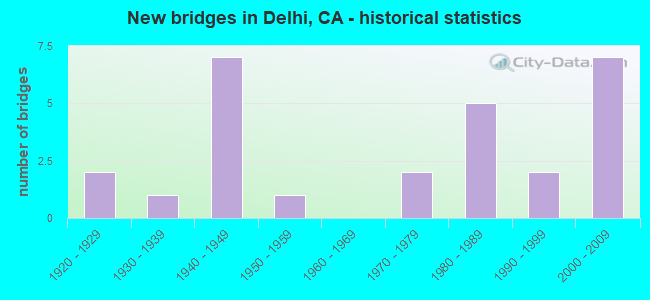
- New bridges - historical statistics
- 21920-1929
- 11930-1939
- 71940-1949
- 11950-1959
- 21970-1979
- 51980-1989
- 21990-1999
- 72000-2009


- Bridge Condition - Deck
- 47.6%Good
- 33.3%Satisfactory
- 19.0%Fair

- Bridge Condition - Superstructure
- 76.2%Good
- 4.8%Satisfactory
- 19.0%Fair

- Bridge Condition - Substructure
- 57.1%Good
- 4.8%Satisfactory
- 38.1%Fair

- Bridge Condition - Channel
- 16.7%Excellent
- 58.3%Very good
- 8.3%Good
- 16.7%Satisfactory

- Bridge Condition - Culverts
- 50.0%Good
- 50.0%Satisfactory
Find on map >> Show street view
Structure Number: 39 0017, Location: 10-MER-099-R35.04 (Lat: 37.443847, Lng: -120.789956), Route carried "on" structure: State highway 99, Year Built: 1935, Year Reconstructed: 1971, Status: Open, Structure Length: 1.10m (3.61ft), Average Daily Traffic: 65,000 (year 2009), Truck Traffic: 25%, Average Future Daily Traffic: 93,978 (year 2041), Features Intersected: TURLOCK CANAL
Minimum Vertical Clearance: 30+ m (98+ ft), Kilometerpoint: 35.040, Lanes on structure: 4, Base Highway Network: Yes (, Subroute: 1), Owner: State Highway Agency, Approaching Roadway Width: 19.9m (65.3ft), Skew: 4 degrees, Material/Design: Concrete continuous, Design/Construction: Culvert, Number Of Spans In Main Unit: 3, Length of Maximum Span: 3.0m (9.8ft), Curb-To-Curb Width: 19.9m (65.3ft), Out-to-Out Width: 20.7m (67.9ft)
Condition: Channel: Excellent, Culverts: Satisfactory, Operating Rating: 27.2 metric tons, Method Used To Determine Operating Rating: Field evaluation and documented engineering judgment, Inventory Rating: 16.2 metric tons, Method Used To Determine Inventory Rating: Field evaluation and documented engineering judgment, Structural Evaluation: Meets minimum limits, Deck Geometry: Better than present minimum criteria, Waterway Adequacy: Equal to present minimum criteria, Approach Roadway Alignment: Equal to present desirable criteria, Designated Inspection Frequency: Every 24 months, Inspection Date: December 2021
Find on map >> Show street view
Structure Number: 39 0146, Location: 10-MER-099-M33.53 (Lat: 37.425922, Lng: -120.771847), Route carried "on" structure: City street , Year Built: 2000, Status: Open, Structure Length: 8.00m (26.25ft), Average Daily Traffic: 800 (year 1998), Truck Traffic: 4%, Average Future Daily Traffic: 1,304 (year 2040), Design Load: HS 20, Features Intersected: STATE ROUTE 99, Facility Carried by Structure: SOUTH AVE
Minimum Vertical Clearance: 30+ m (98+ ft), Kilometerpoint: 0.000, Lanes on structure: 2, Lanes under structure: 4, Owner: State Highway Agency, Approaching Roadway Width: 15.6m (51.2ft), Skew: 3 degrees, Material/Design: Prestressed concrete continuous, Design/Construction: Box Beam or Girders - Multiple, Number Of Spans In Main Unit: 2, Length of Maximum Span: 40.7m (133.5ft), Curb or Sidewalk Widths: Left: 0.0m, Right: 1.5m (4.9ft), Curb-To-Curb Width: 15.6m (51.2ft), Out-to-Out Width: 17.9m (58.7ft)
Condition: Deck: Good, Superstructure: Good, Substructure: Good, Operating Rating: 54.1 metric tons, Method Used To Determine Operating Rating: Assigned rating based on Load Factor Design (LFD) reported in metric tons, Inventory Rating: 32.4 metric tons, Method Used To Determine Inventory Rating: Assigned rating based on Load Factor Design (LFD) reported in metric tons, Structural Evaluation: Better than present minimum criteria, Deck Geometry: Superior to present desirable criteria, Underclear: Somewhat better than minimum adequacy, Approach Roadway Alignment: Equal to present desirable criteria, Designated Inspection Frequency: Every 24 months, Inspection Date: May 2020, Deck Structure Type: Concrete Cast-file-Place
Find on map >> Show street view
Structure Number: 39 0148L, Location: 10-MER-099-R34.05 (Lat: 37.433183, Lng: -120.778544), Route carried "on" structure: State highway 99, Year Built: 1980, Status: Open, Structure Length: 3.77m (12.37ft), Average Daily Traffic: 32,500 (year 2009), Truck Traffic: 25%, Average Future Daily Traffic: 46,833 (year 2040), Design Load: HS 20+Mod, Features Intersected: EL CAPITAN WAY
Minimum Vertical Clearance: 30+ m (98+ ft), Kilometerpoint: 34.050, Lanes on structure: 2, Lanes under structure: 2, Base Highway Network: Yes (, Subroute: 1), Owner: State Highway Agency, Approaching Roadway Width: 11.0m (36.1ft), Material/Design: Prestressed concrete, Design/Construction: Box Beam or Girders - Multiple, Number Of Spans In Main Unit: 1, Length of Maximum Span: 37.3m (122.4ft), Curb-To-Curb Width: 15.3m (50.2ft), Out-to-Out Width: 16.4m (53.8ft)
Condition: Deck: Satisfactory, Superstructure: Good, Substructure: Good, Operating Rating: 54.1 metric tons, Method Used To Determine Operating Rating: Assigned rating based on Load Factor Design (LFD) reported in metric tons, Inventory Rating: 32.4 metric tons, Method Used To Determine Inventory Rating: Assigned rating based on Load Factor Design (LFD) reported in metric tons, Structural Evaluation: Better than present minimum criteria, Deck Geometry: Superior to present desirable criteria, Underclear: Equal to present minimum criteria, Approach Roadway Alignment: Equal to present desirable criteria, Designated Inspection Frequency: Every 24 months, Inspection Date: May 2020, Deck Structure Type: Concrete Cast-file-Place
Find on map >> Show street view
Structure Number: 39 0148R, Location: 10-MER-099-R34.05 (Lat: 37.433383, Lng: -120.778250), Route carried "on" structure: State highway 99, Year Built: 1980, Status: Open, Structure Length: 3.81m (12.50ft), Average Daily Traffic: 32,500 (year 2009), Truck Traffic: 25%, Average Future Daily Traffic: 46,833 (year 2040), Design Load: HS 20+Mod, Features Intersected: EL CAPITAN WAY
Minimum Vertical Clearance: 30+ m (98+ ft), Kilometerpoint: 34.050, Lanes on structure: 2, Lanes under structure: 2, Base Highway Network: Yes (, Subroute: 1), Owner: State Highway Agency, Approaching Roadway Width: 12.2m (40.0ft), Material/Design: Prestressed concrete, Design/Construction: Box Beam or Girders - Multiple, Number Of Spans In Main Unit: 1, Length of Maximum Span: 37.7m (123.7ft), Curb-To-Curb Width: 15.3m (50.2ft), Out-to-Out Width: 16.4m (53.8ft)
Condition: Deck: Satisfactory, Superstructure: Good, Substructure: Good, Operating Rating: 54.1 metric tons, Method Used To Determine Operating Rating: Assigned rating based on Load Factor Design (LFD) reported in metric tons, Inventory Rating: 32.4 metric tons, Method Used To Determine Inventory Rating: Assigned rating based on Load Factor Design (LFD) reported in metric tons, Structural Evaluation: Better than present minimum criteria, Deck Geometry: Superior to present desirable criteria, Underclear: Better than present minimum criteria, Approach Roadway Alignment: Equal to present desirable criteria, Designated Inspection Frequency: Every 24 months, Inspection Date: May 2020, Deck Structure Type: Concrete Cast-file-Place
Find on map >> Show street view
Structure Number: 39 0149, Location: 10-MER-099-R35.56 (Lat: 37.448661, Lng: -120.797722), Route carried "on" structure: County highway , Year Built: 2000, Status: Open, Structure Length: 8.90m (29.20ft), Average Daily Traffic: 800 (year 1998), Truck Traffic: 4%, Average Future Daily Traffic: 1,304 (year 2040), Design Load: HS 20, Features Intersected: STATE ROUTE 99, Facility Carried by Structure: BRADBURY ROAD
Minimum Vertical Clearance: 30+ m (98+ ft), Kilometerpoint: 0.000, Lanes on structure: 2, Lanes under structure: 4, Owner: State Highway Agency, Approaching Roadway Width: 15.6m (51.2ft), Skew: 4 degrees, Material/Design: Prestressed concrete continuous, Design/Construction: Box Beam or Girders - Multiple, Number Of Spans In Main Unit: 2, Length of Maximum Span: 47.0m (154.2ft), Curb or Sidewalk Widths: Left: 0.0m, Right: 1.5m (4.9ft), Curb-To-Curb Width: 15.6m (51.2ft), Out-to-Out Width: 17.9m (58.7ft)
Condition: Deck: Satisfactory, Superstructure: Good, Substructure: Good, Operating Rating: 54.1 metric tons, Method Used To Determine Operating Rating: Assigned rating based on Load Factor Design (LFD) reported in metric tons, Inventory Rating: 32.4 metric tons, Method Used To Determine Inventory Rating: Assigned rating based on Load Factor Design (LFD) reported in metric tons, Structural Evaluation: Better than present minimum criteria, Deck Geometry: Superior to present desirable criteria, Underclear: Somewhat better than minimum adequacy, Approach Roadway Alignment: Equal to present desirable criteria, Designated Inspection Frequency: Every 24 months, Inspection Date: May 2020, Deck Structure Type: Concrete Cast-file-Place
Find on map >> Show street view
Structure Number: 39 0191K, Location: 10-MER-099-R36.34 (Lat: 37.456797, Lng: -120.806461), Route carried "on" structure: Ramp State highway 99, Year Built: 1973, Status: Open, Structure Length: 9.88m (32.41ft), Average Daily Traffic: 3,590 (year 1998), Truck Traffic: 8%, Average Future Daily Traffic: 5,434 (year 2040), Design Load: HS 20+Mod, Features Intersected: STATE ROUTE 99
Minimum Vertical Clearance: 30+ m (98+ ft), Kilometerpoint: 36.340, Lanes on structure: 1, Lanes under structure: 6, Owner: State Highway Agency, Approaching Roadway Width: 7.3m (24.0ft), Skew: 4 degrees, Material/Design: Prestressed concrete continuous, Design/Construction: Box Beam or Girders - Multiple, Number Of Spans In Main Unit: 2, Length of Maximum Span: 49.3m (161.7ft), Curb-To-Curb Width: 7.3m (24.0ft), Out-to-Out Width: 7.9m (25.9ft)
Condition: Deck: Good, Superstructure: Good, Substructure: Good, Operating Rating: 78.4 metric tons, Method Used To Determine Operating Rating: Load Factor (LF), Inventory Rating: 32.4 metric tons, Method Used To Determine Inventory Rating: Load Factor (LF), Structural Evaluation: Better than present minimum criteria, Deck Geometry: Better than present minimum criteria, Underclear: Meets minimum limits, Approach Roadway Alignment: Equal to present desirable criteria, Designated Inspection Frequency: Every 24 months, Inspection Date: May 2020, Deck Structure Type: Concrete Cast-file-Place, Wearing Surface/Protective System: Wearing Surface: Bituminous
Find on map >> Show street view
Structure Number: 39 0196, Location: 10-MER-099-R34.43 (Lat: 37.436811, Lng: -120.783642), Route carried "on" structure: County highway , Year Built: 1980, Status: Open, Structure Length: 7.65m (25.10ft), Average Daily Traffic: 3,700 (year 1998), Truck Traffic: 3%, Average Future Daily Traffic: 6,630 (year 2040), Design Load: HS 20+Mod, Features Intersected: STATE ROUTE 99, Facility Carried by Structure: SHANKS ROAD
Minimum Vertical Clearance: 30+ m (98+ ft), Kilometerpoint: 0.000, Lanes on structure: 2, Lanes under structure: 4, Owner: State Highway Agency, Approaching Roadway Width: 21.9m (71.9ft), Skew: 1 degrees, Material/Design: Prestressed concrete continuous, Design/Construction: Box Beam or Girders - Multiple, Number Of Spans In Main Unit: 2, Length of Maximum Span: 39.6m (129.9ft), Curb or Sidewalk Widths: Left: 2.1m (6.9ft), Right: 1.8m (5.9ft), Curb-To-Curb Width: 15.8m (51.8ft), Out-to-Out Width: 20.4m (66.9ft)
Condition: Deck: Good, Superstructure: Good, Substructure: Good, Operating Rating: 54.1 metric tons, Method Used To Determine Operating Rating: Assigned rating based on Load Factor Design (LFD) reported in metric tons, Inventory Rating: 32.4 metric tons, Method Used To Determine Inventory Rating: Assigned rating based on Load Factor Design (LFD) reported in metric tons, Structural Evaluation: Better than present minimum criteria, Deck Geometry: Superior to present desirable criteria, Underclear: Equal to present minimum criteria, Approach Roadway Alignment: Equal to present desirable criteria, Designated Inspection Frequency: Every 24 months, Inspection Date: May 2020, Deck Structure Type: Concrete Cast-file-Place
Find on map >> Show street view
Structure Number: 39 0224L, Location: 10-MER-099-R31.93 (Lat: 37.408783, Lng: -120.752167), Route carried "on" structure: State highway 99, Year Built: 1997, Status: Open, Structure Length: 3.12m (10.24ft), Average Daily Traffic: 32,000 (year 2009), Truck Traffic: 25%, Average Future Daily Traffic: 47,459 (year 2040), Design Load: HS 20+Mod, Features Intersected: COLLIER ROAD
Minimum Vertical Clearance: 30+ m (98+ ft), Kilometerpoint: 31.930, Lanes on structure: 2, Lanes under structure: 2, Base Highway Network: Yes (, Subroute: 1), Owner: State Highway Agency, Approaching Roadway Width: 11.9m (39.0ft), Material/Design: Prestressed concrete, Design/Construction: Box Beam or Girders - Multiple, Number Of Spans In Main Unit: 1, Length of Maximum Span: 29.9m (98.1ft), Curb-To-Curb Width: 11.9m (39.0ft), Out-to-Out Width: 12.9m (42.3ft)
Condition: Deck: Satisfactory, Superstructure: Good, Substructure: Good, Operating Rating: 54.1 metric tons, Method Used To Determine Operating Rating: Assigned rating based on Load Factor Design (LFD) reported in metric tons, Inventory Rating: 32.4 metric tons, Method Used To Determine Inventory Rating: Assigned rating based on Load Factor Design (LFD) reported in metric tons, Structural Evaluation: Better than present minimum criteria, Deck Geometry: Better than present minimum criteria, Underclear: Somewhat better than minimum adequacy, Approach Roadway Alignment: Equal to present desirable criteria, Designated Inspection Frequency: Every 24 months, Inspection Date: May 2020, Deck Structure Type: Concrete Cast-file-Place
Find on map >> Show street view
Structure Number: 39 0224R, Location: 10-MER-099-R31.93 (Lat: 37.408967, Lng: -120.751806), Route carried "on" structure: State highway 99, Year Built: 1997, Status: Open, Structure Length: 3.02m (9.91ft), Average Daily Traffic: 32,000 (year 2009), Truck Traffic: 25%, Average Future Daily Traffic: 47,459 (year 2040), Design Load: HS 20+Mod, Features Intersected: COLLIER ROAD
Minimum Vertical Clearance: 30+ m (98+ ft), Kilometerpoint: 31.930, Lanes on structure: 2, Lanes under structure: 2, Base Highway Network: Yes (, Subroute: 1), Owner: State Highway Agency, Approaching Roadway Width: 11.9m (39.0ft), Material/Design: Prestressed concrete, Design/Construction: Box Beam or Girders - Multiple, Number Of Spans In Main Unit: 1, Length of Maximum Span: 28.9m (94.8ft), Curb-To-Curb Width: 11.9m (39.0ft), Out-to-Out Width: 12.9m (42.3ft)
Condition: Deck: Satisfactory, Superstructure: Good, Substructure: Good, Operating Rating: 54.1 metric tons, Method Used To Determine Operating Rating: Assigned rating based on Load Factor Design (LFD) reported in metric tons, Inventory Rating: 32.4 metric tons, Method Used To Determine Inventory Rating: Assigned rating based on Load Factor Design (LFD) reported in metric tons, Structural Evaluation: Better than present minimum criteria, Deck Geometry: Better than present minimum criteria, Underclear: Somewhat better than minimum adequacy, Approach Roadway Alignment: Equal to present desirable criteria, Designated Inspection Frequency: Every 24 months, Inspection Date: May 2020, Deck Structure Type: Concrete Cast-file-Place
Find on map >> Show street view
Structure Number: 39C0042, Location: 0.2 MI EAST OF SR 99 (Lat: 37.426161, Lng: -120.769700), Route carried "on" structure: County highway , Year Built: 2000, Status: Open, Structure Length: 5.37m (17.62ft), Average Daily Traffic: 3,500 (year 2000), Truck Traffic: 3%, Average Future Daily Traffic: 5,326 (year 2037), Design Load: HS 20+Mod, Features Intersected: UP RR TRACKS, Facility Carried by Structure: SOUTH AVENUE
Minimum Vertical Clearance: 30+ m (98+ ft), Kilometerpoint: 0.000, Lanes on structure: 2, Owner: City or Municipal Highway Agency, Approaching Roadway Width: 12.0m (39.4ft), Skew: 3 degrees, Material/Design: Prestressed concrete continuous, Design/Construction: Box Beam or Girders - Multiple, Number Of Spans In Main Unit: 3, Length of Maximum Span: 21.8m (71.5ft), Curb or Sidewalk Widths: Left: 0.0m, Right: 1.5m (4.9ft), Curb-To-Curb Width: 12.0m (39.4ft), Out-to-Out Width: 14.3m (46.9ft)
Condition: Deck: Good, Superstructure: Good, Substructure: Good, Operating Rating: 54.1 metric tons, Method Used To Determine Operating Rating: Assigned rating based on Load Factor Design (LFD) reported in metric tons, Inventory Rating: 32.4 metric tons, Method Used To Determine Inventory Rating: Assigned rating based on Load Factor Design (LFD) reported in metric tons, Structural Evaluation: Better than present minimum criteria, Deck Geometry: Somewhat better than minimum adequacy, Underclear: Superior to present desirable criteria, Approach Roadway Alignment: Equal to present desirable criteria, Designated Inspection Frequency: Every 48 months, Inspection Date: October 2019, Deck Structure Type: Concrete Cast-file-Place
Find on map >> Show street view
Structure Number: 39C0043, Location: 0.2 MI EAST OF SR 99 (Lat: 37.448656, Lng: -120.795258), Route carried "on" structure: Business City street , Year Built: 2000, Status: Open, Structure Length: 6.16m (20.21ft), Average Daily Traffic: 2,196 (year 2000), Truck Traffic: 3%, Average Future Daily Traffic: 5,326 (year 2037), Design Load: HS 20+Mod, Features Intersected: UP RR TRACKS, Facility Carried by Structure: BRADBURY ROAD
Minimum Vertical Clearance: 30+ m (98+ ft), Kilometerpoint: 0.000, Lanes on structure: 2, Owner: County Highway Agency, Approaching Roadway Width: 12.0m (39.4ft), Skew: 4 degrees, Material/Design: Prestressed concrete continuous, Design/Construction: Box Beam or Girders - Multiple, Number Of Spans In Main Unit: 3, Length of Maximum Span: 24.4m (80.1ft), Curb or Sidewalk Widths: Left: 0.0m, Right: 1.5m (4.9ft), Curb-To-Curb Width: 12.0m (39.4ft), Out-to-Out Width: 14.3m (46.9ft)
Condition: Deck: Good, Superstructure: Good, Substructure: Good, Operating Rating: 54.1 metric tons, Method Used To Determine Operating Rating: Assigned rating based on Load Factor Design (LFD) reported in metric tons, Inventory Rating: 32.4 metric tons, Method Used To Determine Inventory Rating: Assigned rating based on Load Factor Design (LFD) reported in metric tons, Structural Evaluation: Better than present minimum criteria, Deck Geometry: Somewhat better than minimum adequacy, Underclear: Better than present minimum criteria, Approach Roadway Alignment: Equal to present desirable criteria, Designated Inspection Frequency: Every 48 months, Inspection Date: October 2019, Deck Structure Type: Concrete Cast-file-Place
Find on map >> Show street view
Structure Number: 39C0053, Location: AT SR 99 IN DELHI (Lat: 37.437328, Lng: -120.782408), Route carried "on" structure: County highway , Year Built: 1980, Status: Open, Structure Length: 4.85m (15.91ft), Average Daily Traffic: 491 (year 2000), Truck Traffic: 20%, Average Future Daily Traffic: 1,636 (year 2041), Design Load: HS 20+Mod, Features Intersected: UP RR, Facility Carried by Structure: SHANKS ROAD
Minimum Vertical Clearance: 30+ m (98+ ft), Kilometerpoint: 0.000, Lanes on structure: 2, Owner: County Highway Agency, Approaching Roadway Width: 9.8m (32.2ft), Skew: 1 degrees, Material/Design: Concrete continuous, Design/Construction: Tee Beam, Number Of Spans In Main Unit: 3, Length of Maximum Span: 19.2m (63.0ft), Curb or Sidewalk Widths: Left: 2.1m (6.9ft), Right: 2.1m (6.9ft), Curb-To-Curb Width: 13.0m (42.7ft), Out-to-Out Width: 18.1m (59.4ft)
Condition: Deck: Satisfactory, Superstructure: Good, Substructure: Good, Operating Rating: 54.1 metric tons, Method Used To Determine Operating Rating: Assigned rating based on Load Factor Design (LFD) reported in metric tons, Inventory Rating: 32.4 metric tons, Method Used To Determine Inventory Rating: Assigned rating based on Load Factor Design (LFD) reported in metric tons, Structural Evaluation: Better than present minimum criteria, Deck Geometry: Superior to present desirable criteria, Underclear: Superior to present desirable criteria, Approach Roadway Alignment: Equal to present minimum criteria, Designated Inspection Frequency: Every 24 months, Inspection Date: October 2021, Deck Structure Type: Concrete Cast-file-Place
Find on map >> Show street view
Structure Number: 39C0091, Location: SOUTH AVE (Lat: 37.426464, Lng: -120.740303), Route carried "on" structure: County highway , Year Built: 1940, Status: Open, Structure Length: 1.22m (4.00ft), Average Daily Traffic: 727 (year 2008), Truck Traffic: 25%, Average Future Daily Traffic: 1,203 (year 2042), Features Intersected: HIGH LINE CANAL, Facility Carried by Structure: CORTEZ ROAD
Minimum Vertical Clearance: 30+ m (98+ ft), Kilometerpoint: 0.000, Lanes on structure: 2, Owner: County Highway Agency, Approaching Roadway Width: 6.7m (22.0ft), Material/Design: Wood or Timber, Design/Construction: Stringer/Multi-beam, Number Of Spans In Main Unit: 2, Length of Maximum Span: 5.8m (19.0ft), Curb-To-Curb Width: 7.7m (25.3ft), Out-to-Out Width: 8.0m (26.2ft)
Condition: Deck: Fair, Superstructure: Fair, Substructure: Fair, Channel: Good, Operating Rating: 35.3 metric tons, Method Used To Determine Operating Rating: Allowable Stress (AS), Inventory Rating: 25.3 metric tons, Method Used To Determine Inventory Rating: Allowable Stress (AS), Structural Evaluation: Somewhat better than minimum adequacy, Deck Geometry: Meets minimum limits, Waterway Adequacy: Equal to present desirable criteria, Approach Roadway Alignment: Equal to present desirable criteria, Designated Inspection Frequency: Every 24 months, Inspection Date: January 2022, Deck Structure Type: Wood or Timber, Wearing Surface/Protective System: Wearing Surface: Bituminous
Find on map >> Show street view
Structure Number: 39C0108, Location: 0.4 MI E OF MERCED AVE (Lat: 37.463269, Lng: -120.786944), Route carried "on" structure: County highway , Year Built: 1924, Status: Posted for load, Structure Length: 0.70m (2.30ft), Average Daily Traffic: 173 (year 2008), Truck Traffic: 26%, Average Future Daily Traffic: 328 (year 2042), Design Load: HS 20, Features Intersected: LATERAL #6, Facility Carried by Structure: HARDING AVENUE
Minimum Vertical Clearance: 30+ m (98+ ft), Kilometerpoint: 0.000, Lanes on structure: 2, Owner: County Highway Agency, Approaching Roadway Width: 5.5m (18.0ft), Skew: 1 degrees, Material/Design: Concrete, Design/Construction: Slab, Number Of Spans In Main Unit: 1, Length of Maximum Span: 6.7m (22.0ft), Curb-To-Curb Width: 6.7m (22.0ft), Out-to-Out Width: 7.3m (24.0ft)
Condition: Deck: Good, Superstructure: Good, Substructure: Fair, Channel: Very good, Operating Rating: 20.7 metric tons, Method Used To Determine Operating Rating: Load Factor (LF), Inventory Rating: 12.3 metric tons, Method Used To Determine Inventory Rating: Load Factor (LF), Structural Evaluation: Meets minimum limits, Deck Geometry: Meets minimum limits, Waterway Adequacy: Equal to present desirable criteria, Approach Roadway Alignment: Equal to present desirable criteria, Bridge Posting: Required (Relationship of Operating Rating to Maximum Legal Load: 20.0 - 29.9% below), Designated Inspection Frequency: Every 24 months, Inspection Date: January 2022, Deck Structure Type: Concrete Cast-file-Place, Wearing Surface/Protective System: Wearing Surface: Bituminous
Find on map >> Show street view
Structure Number: 39C0127, Location: 0.3 MI S OF BLOSS AVE (Lat: 37.400750, Lng: -120.777658), Route carried "on" structure: County highway , Year Built: 1940, Status: Open, Structure Length: 0.73m (2.40ft), Average Daily Traffic: 610 (year 2008), Truck Traffic: 7%, Average Future Daily Traffic: 711 (year 2042), Features Intersected: HIGH LINE CANAL, Facility Carried by Structure: HINTON AVENUE
Minimum Vertical Clearance: 30+ m (98+ ft), Kilometerpoint: 0.000, Lanes on structure: 2, Owner: County Highway Agency, Approaching Roadway Width: 5.5m (18.0ft), Skew: 2 degrees, Material/Design: Concrete continuous, Design/Construction: Slab, Number Of Spans In Main Unit: 2, Length of Maximum Span: 3.7m (12.1ft), Curb or Sidewalk Widths: Left: 0.2m (0.7ft), Right: 0.2m (0.7ft), Curb-To-Curb Width: 7.3m (24.0ft), Out-to-Out Width: 7.7m (25.3ft)
Condition: Deck: Fair, Superstructure: Fair, Substructure: Fair, Channel: Excellent, Operating Rating: 26.9 metric tons, Method Used To Determine Operating Rating: Field evaluation and documented engineering judgment, Inventory Rating: 16.2 metric tons, Method Used To Determine Inventory Rating: Field evaluation and documented engineering judgment, Structural Evaluation: Meets minimum limits, Deck Geometry: Meets minimum limits, Waterway Adequacy: Equal to present desirable criteria, Approach Roadway Alignment: Equal to present desirable criteria, Designated Inspection Frequency: Every 24 months, Inspection Date: January 2022, Deck Structure Type: Concrete Cast-file-Place, Wearing Surface/Protective System: Wearing Surface: Bituminous
Find on map >> Show street view
Structure Number: 39C0128, Location: 0.5 MI N BLOSS AVE (Lat: 37.412514, Lng: -120.759200), Route carried "on" structure: County highway , Year Built: 1940, Status: Open, Structure Length: 0.82m (2.69ft), Average Daily Traffic: 1,272 (year 2008), Truck Traffic: 10%, Average Future Daily Traffic: 1,805 (year 2042), Features Intersected: HIGH LINE CANAL, Facility Carried by Structure: SYCAMORE STREET
Minimum Vertical Clearance: 30+ m (98+ ft), Kilometerpoint: 0.000, Lanes on structure: 2, Owner: County Highway Agency, Approaching Roadway Width: 7.0m (23.0ft), Material/Design: Concrete continuous, Design/Construction: Slab, Number Of Spans In Main Unit: 2, Length of Maximum Span: 4.0m (13.1ft), Curb or Sidewalk Widths: Left: 0.2m (0.7ft), Right: 0.2m (0.7ft), Curb-To-Curb Width: 7.3m (24.0ft), Out-to-Out Width: 7.8m (25.6ft)
Condition: Deck: Good, Superstructure: Good, Substructure: Fair, Channel: Very good, Operating Rating: 26.9 metric tons, Method Used To Determine Operating Rating: Field evaluation and documented engineering judgment, Inventory Rating: 16.2 metric tons, Method Used To Determine Inventory Rating: Field evaluation and documented engineering judgment, Structural Evaluation: Meets minimum limits, Deck Geometry: Meets minimum limits, Waterway Adequacy: Equal to present desirable criteria, Approach Roadway Alignment: Equal to present desirable criteria, Designated Inspection Frequency: Every 24 months, Inspection Date: January 2022, Deck Structure Type: Concrete Cast-file-Place, Wearing Surface/Protective System: Wearing Surface: Bituminous
Find on map >> Show street view
Structure Number: 39C0129, Location: 0.3 MI W MERCED AVE (Lat: 37.463811, Lng: -120.798964), Route carried "on" structure: County highway , Year Built: 1940, Status: Open, Structure Length: 0.73m (2.40ft), Average Daily Traffic: 65 (year 1980), Average Future Daily Traffic: 109 (year 2042), Features Intersected: LATERAL #5, Facility Carried by Structure: ROSELAWN AVENUE
Minimum Vertical Clearance: 30+ m (98+ ft), Kilometerpoint: 0.000, Lanes on structure: 2, Owner: County Highway Agency, Approaching Roadway Width: 5.8m (19.0ft), Material/Design: Concrete continuous, Design/Construction: Slab, Number Of Spans In Main Unit: 2, Length of Maximum Span: 3.4m (11.2ft), Curb or Sidewalk Widths: Left: 0.1m (0.3ft), Right: 0.1m (0.3ft), Curb-To-Curb Width: 7.1m (23.3ft), Out-to-Out Width: 7.3m (24.0ft)
Condition: Deck: Fair, Superstructure: Fair, Substructure: Fair, Channel: Very good, Operating Rating: 26.9 metric tons, Method Used To Determine Operating Rating: Field evaluation and documented engineering judgment, Inventory Rating: 16.2 metric tons, Method Used To Determine Inventory Rating: Field evaluation and documented engineering judgment, Structural Evaluation: Somewhat better than minimum adequacy, Deck Geometry: Somewhat better than minimum adequacy, Waterway Adequacy: Better than present minimum criteria, Approach Roadway Alignment: Equal to present minimum criteria, Designated Inspection Frequency: Every 24 months, Inspection Date: January 2022, Deck Structure Type: Concrete Cast-file-Place, Wearing Surface/Protective System: Wearing Surface: Bituminous
Find on map >> Show street view
Structure Number: 39C013, Location: AT CANAL DRIVE (Lat: 37.419269, Lng: -120.745792), Route carried "on" structure: County highway , Year Built: 1940, Status: Open, Structure Length: 0.81m (2.66ft), Average Daily Traffic: 125 (year 2008), Truck Traffic: 21%, Average Future Daily Traffic: 438 (year 2042), Features Intersected: HIGH LINE CANAL, Facility Carried by Structure: SECOND AVENUE
Minimum Vertical Clearance: 30+ m (98+ ft), Kilometerpoint: 0.000, Lanes on structure: 2, Owner: County Highway Agency, Approaching Roadway Width: 5.8m (19.0ft), Skew: 1 degrees, Material/Design: Concrete continuous, Design/Construction: Slab, Number Of Spans In Main Unit: 2, Length of Maximum Span: 4.0m (13.1ft), Curb or Sidewalk Widths: Left: 0.2m (0.7ft), Right: 0.2m (0.7ft), Curb-To-Curb Width: 7.3m (24.0ft), Out-to-Out Width: 7.7m (25.3ft)
Condition: Deck: Fair, Superstructure: Fair, Substructure: Fair, Channel: Very good, Operating Rating: 26.9 metric tons, Method Used To Determine Operating Rating: Field evaluation and documented engineering judgment, Inventory Rating: 16.2 metric tons, Method Used To Determine Inventory Rating: Field evaluation and documented engineering judgment, Structural Evaluation: Somewhat better than minimum adequacy, Deck Geometry: Somewhat better than minimum adequacy, Waterway Adequacy: Equal to present desirable criteria, Approach Roadway Alignment: Equal to present desirable criteria, Designated Inspection Frequency: Every 24 months, Inspection Date: January 2022, Deck Structure Type: Concrete Cast-file-Place
Find on map >> Show street view
Structure Number: 39C0131, Location: 0.3 MI W CORTEZ AVE (Lat: 37.426469, Lng: -120.745767), Route carried "on" structure: County highway , Year Built: 1940, Status: Open, Structure Length: 0.79m (2.59ft), Average Daily Traffic: 266 (year 2008), Truck Traffic: 8%, Average Future Daily Traffic: 510 (year 2042), Features Intersected: HIGH LINE CANAL, Facility Carried by Structure: SOUTH AVE
Minimum Vertical Clearance: 30+ m (98+ ft), Kilometerpoint: 0.000, Lanes on structure: 2, Owner: County Highway Agency, Approaching Roadway Width: 7.6m (24.9ft), Material/Design: Concrete continuous, Design/Construction: Slab, Number Of Spans In Main Unit: 2, Length of Maximum Span: 3.9m (12.8ft), Curb or Sidewalk Widths: Left: 0.2m (0.7ft), Right: 0.2m (0.7ft), Curb-To-Curb Width: 7.3m (24.0ft), Out-to-Out Width: 7.7m (25.3ft)
Condition: Deck: Good, Superstructure: Good, Substructure: Fair, Channel: Satisfactory, Operating Rating: 26.9 metric tons, Method Used To Determine Operating Rating: Field evaluation and documented engineering judgment, Inventory Rating: 16.2 metric tons, Method Used To Determine Inventory Rating: Field evaluation and documented engineering judgment, Structural Evaluation: Somewhat better than minimum adequacy, Deck Geometry: Somewhat better than minimum adequacy, Waterway Adequacy: Equal to present desirable criteria, Approach Roadway Alignment: Somewhat better than minimum adequacy, Designated Inspection Frequency: Every 24 months, Inspection Date: January 2022, Deck Structure Type: Concrete Cast-file-Place, Wearing Surface/Protective System: Wearing Surface: Bituminous
Find on map >> Show street view
Structure Number: 39C0296, Location: 0.3 MI E MERCED AVE (Lat: 37.448647, Lng: -120.788847), Route carried "on" structure: County highway , Year Built: 1925, Status: Open, Structure Length: 1.46m (4.79ft), Average Daily Traffic: 2,325 (year 2008), Truck Traffic: 29%, Average Future Daily Traffic: 2,735 (year 2042), Features Intersected: LATERAL #6, Facility Carried by Structure: BRADBURY ROAD
Minimum Vertical Clearance: 30+ m (98+ ft), Kilometerpoint: 0.000, Lanes on structure: 2, Owner: County Highway Agency, Approaching Roadway Width: 6.1m (20.0ft), Skew: 4 degrees, Material/Design: Concrete continuous, Design/Construction: Slab, Number Of Spans In Main Unit: 2, Length of Maximum Span: 4.7m (15.4ft), Curb-To-Curb Width: 6.8m (22.3ft), Out-to-Out Width: 7.4m (24.3ft)
Condition: Deck: Good, Superstructure: Good, Substructure: Good, Channel: Very good, Operating Rating: 30.5 metric tons, Method Used To Determine Operating Rating: Load and Resistance Factor Rating (LRFR) rating reported by rating factor(RF) method using HL-93 loadings, Inventory Rating: 23.3 metric tons, Method Used To Determine Inventory Rating: Load and Resistance Factor Rating (LRFR) rating reported by rating factor(RF) method using HL-93 loadings, Structural Evaluation: Equal to present minimum criteria, Deck Geometry: High priority of replacement, Waterway Adequacy: Equal to present desirable criteria, Approach Roadway Alignment: Equal to present desirable criteria, Designated Inspection Frequency: Every 24 months, Inspection Date: January 2022, Deck Structure Type: Concrete Cast-file-Place, Wearing Surface/Protective System: Wearing Surface: Bituminous
Find on map >> Show street view
Structure Number: 39C031, Location: 1.35 MI SOUTH OF SR 99 (Lat: 37.428683, Lng: -120.795161), Route carried "on" structure: County highway , Year Built: 1948, Status: Open, Structure Length: 0.79m (2.59ft), Average Daily Traffic: 2,249 (year 2008), Truck Traffic: 4%, Average Future Daily Traffic: 3,283 (year 2042), Features Intersected: LATERAL #6, Facility Carried by Structure: MERCED AVENUE
Minimum Vertical Clearance: 30+ m (98+ ft), Kilometerpoint: 0.000, Lanes on structure: 2, Owner: County Highway Agency, Approaching Roadway Width: 6.4m (21.0ft), Material/Design: Concrete continuous, Design/Construction: Slab, Number Of Spans In Main Unit: 2, Length of Maximum Span: 3.8m (12.5ft), Curb or Sidewalk Widths: Left: 0.2m (0.7ft), Right: 0.2m (0.7ft), Curb-To-Curb Width: 7.3m (24.0ft), Out-to-Out Width: 7.7m (25.3ft)
Condition: Deck: Good, Superstructure: Good, Substructure: Fair, Channel: Satisfactory, Operating Rating: 26.9 metric tons, Method Used To Determine Operating Rating: Field evaluation and documented engineering judgment, Inventory Rating: 16.2 metric tons, Method Used To Determine Inventory Rating: Field evaluation and documented engineering judgment, Structural Evaluation: Meets minimum limits, Deck Geometry: High priority of replacement, Waterway Adequacy: Superior to present desirable criteria, Approach Roadway Alignment: Equal to present minimum criteria, Designated Inspection Frequency: Every 24 months, Inspection Date: January 2022, Deck Structure Type: Concrete Cast-file-Place, Wearing Surface/Protective System: Wearing Surface: Bituminous
Find on map >> Show street view
Structure Number: 39C0311, Location: 0.5 MI E OF MERCED AVE (Lat: 37.433975, Lng: -120.786553), Route carried "on" structure: County highway , Year Built: 2009, Status: Open, Structure Length: 0.88m (2.89ft), Average Daily Traffic: 2,712 (year 2008), Truck Traffic: 9%, Average Future Daily Traffic: 1,274 (year 2038), Design Load: HS 20, Features Intersected: LATERAL #6, Facility Carried by Structure: LETTEAU AVENUE
Minimum Vertical Clearance: 30+ m (98+ ft), Kilometerpoint: 0.000, Lanes on structure: 2, Owner: County Highway Agency, Approaching Roadway Width: 14.0m (45.9ft), Skew: 1 degrees, Material/Design: Concrete continuous, Design/Construction: Culvert, Number Of Spans In Main Unit: 3, Length of Maximum Span: 2.8m (9.2ft), Curb or Sidewalk Widths: Left: 1.0m (3.3ft), Right: 1.0m (3.3ft), Curb-To-Curb Width: 15.4m (50.5ft), Out-to-Out Width: 17.4m (57.1ft)
Condition: Channel: Very good, Culverts: Good, Operating Rating: 54.1 metric tons, Method Used To Determine Operating Rating: Field evaluation and documented engineering judgment, Inventory Rating: 32.4 metric tons, Method Used To Determine Inventory Rating: Field evaluation and documented engineering judgment, Structural Evaluation: Better than present minimum criteria, Deck Geometry: Superior to present desirable criteria, Waterway Adequacy: Equal to present minimum criteria, Approach Roadway Alignment: Equal to present desirable criteria, Designated Inspection Frequency: Every 48 months, Inspection Date: January 2020
Find on map >> Show street view
Structure Number: 39C0312, Location: 0.5 MI SOUTH BLOSS AVE (Lat: 37.396858, Lng: -120.795917), Route carried "on" structure: County highway , Year Built: 1955, Status: Open, Structure Length: 0.70m (2.30ft), Average Daily Traffic: 50 (year 1980), Average Future Daily Traffic: 83 (year 2042), Features Intersected: HIGH LINE CANAL, Facility Carried by Structure: MERCED AVENUE
Minimum Vertical Clearance: 30+ m (98+ ft), Kilometerpoint: 0.000, Lanes on structure: 2, Owner: County Highway Agency, Approaching Roadway Width: 4.6m (15.1ft), Material/Design: Concrete continuous, Design/Construction: Slab, Number Of Spans In Main Unit: 2, Length of Maximum Span: 3.4m (11.2ft), Curb or Sidewalk Widths: Left: 0.2m (0.7ft), Right: 0.2m (0.7ft), Curb-To-Curb Width: 7.5m (24.6ft), Out-to-Out Width: 7.9m (25.9ft)
Condition: Deck: Satisfactory, Superstructure: Satisfactory, Substructure: Satisfactory, Channel: Very good, Operating Rating: 38.9 metric tons, Method Used To Determine Operating Rating: Load Factor (LF), Inventory Rating: 23.3 metric tons, Method Used To Determine Inventory Rating: Load Factor (LF), Structural Evaluation: Equal to present minimum criteria, Deck Geometry: Equal to present minimum criteria, Waterway Adequacy: Equal to present desirable criteria, Approach Roadway Alignment: Equal to present desirable criteria, Designated Inspection Frequency: Every 24 months, Inspection Date: January 2022, Deck Structure Type: Concrete Cast-file-Place
Find on map >> Show street view
Structure Number: 39 0146, Location: 10-MER-099-M33.53 (Lat: 37.425922, Lng: -120.771847), Route carried "under" structure: State highway 99, Year Built: 2000, Structure Length: 0. m, Average Daily Traffic: 65,000 (year 2009), Truck Traffic: 25%, Features Intersected: STATE ROUTE 99, Facility Carried by Structure: SOUTH AVE
Minimum Vertical Clearance: 5.46m (17.91ft), Kilometerpoint: 33.530, Lanes on structure: 2, Lanes under structure: 4, Material/Design: Prestressed concrete continuous, Design/Construction: Box Beam or Girders - Multiple, Length of Maximum Span: 40.7m (133.5ft)
Find on map >> Show street view
Structure Number: 39 0149, Location: 10-MER-099-R35.56 (Lat: 37.448661, Lng: -120.797722), Route carried "under" structure: State highway 99, Year Built: 2000, Structure Length: 0. m, Average Daily Traffic: 65,000 (year 2009), Truck Traffic: 25%, Features Intersected: STATE ROUTE 99, Facility Carried by Structure: BRADBURY ROAD
Minimum Vertical Clearance: 5.51m (18.08ft), Kilometerpoint: 35.560, Lanes on structure: 2, Lanes under structure: 4, Material/Design: Prestressed concrete continuous, Design/Construction: Box Beam or Girders - Multiple, Length of Maximum Span: 47.0m (154.2ft)
Find on map >> Show street view
Structure Number: 39 0191K, Location: 10-MER-099-R36.34 (Lat: 37.456797, Lng: -120.806461), Route carried "under" structure: State highway 99, Year Built: 1973, Structure Length: 0. m, Average Daily Traffic: 38,000 (year 1998), Truck Traffic: 27%, Features Intersected: STATE ROUTE 99
Minimum Vertical Clearance: 5.25m (17.22ft), Kilometerpoint: 36.340, Lanes on structure: 1, Lanes under structure: 6, Material/Design: Prestressed concrete continuous, Design/Construction: Box Beam or Girders - Multiple, Length of Maximum Span: 49.3m (161.7ft)
Find on map >> Show street view
Structure Number: 39 0196, Location: 10-MER-099-R34.43 (Lat: 37.436811, Lng: -120.783642), Route carried "under" structure: State highway 99, Year Built: 1980, Structure Length: 0. m, Average Daily Traffic: 65,000 (year 2009), Truck Traffic: 25%, Features Intersected: STATE ROUTE 99, Facility Carried by Structure: SHANKS ROAD
Minimum Vertical Clearance: 5.28m (17.32ft), Kilometerpoint: 34.430, Lanes on structure: 2, Lanes under structure: 4, Material/Design: Prestressed concrete continuous, Design/Construction: Box Beam or Girders - Multiple, Length of Maximum Span: 39.6m (129.9ft)