Bridge Statistics for Damascus, Oregon (OR)
Condition, Traffic, Stress, Structural Evaluation, Project Costs
- National Bridge Inventory (NBI) Statistics
- 22Number of bridges
- 292ft / 89.3mTotal length
- $2,375,000Total costs
- 230,419Total average daily traffic
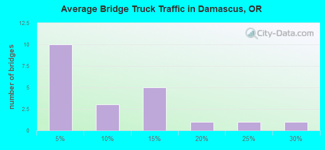
- 11,598Total average daily truck traffic
- National Bridge Inventory (NBI) Registered Bridges for Damascus
- No street view available for this location
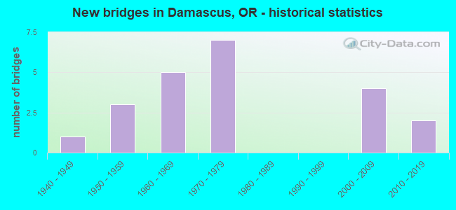
- New bridges - historical statistics
- 11940-1949
- 31950-1959
- 51960-1969
- 71970-1979
- 42000-2009
- 22010-2019

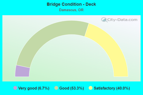
- Bridge Condition - Deck
- 6.7%Very good
- 53.3%Good
- 40.0%Satisfactory
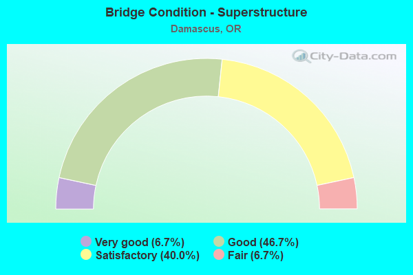
- Bridge Condition - Superstructure
- 6.7%Very good
- 46.7%Good
- 40.0%Satisfactory
- 6.7%Fair
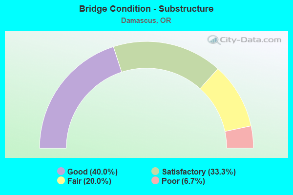
- Bridge Condition - Substructure
- 40.0%Good
- 33.3%Satisfactory
- 20.0%Fair
- 6.7%Poor
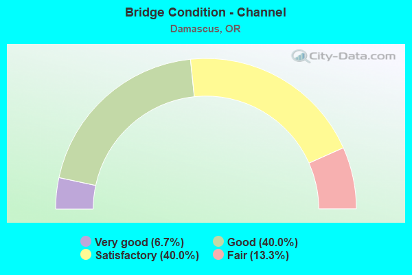
- Bridge Condition - Channel
- 6.7%Very good
- 40.0%Good
- 40.0%Satisfactory
- 13.3%Fair

- Bridge Condition - Culverts
- 50.0%Good
- 50.0%Fair
Find on map >> Show street view
Structure Number: 2082A171 0139, Location: 4.0 MI NW EAGLE CREEK (Lat: 45.393969, Lng: -122.420739), Route carried "on" structure: State highway 224, Year Built: 1948, Status: Open, Structure Length: 5.06m (16.60ft), Average Daily Traffic: 11,221 (year 2020), Truck Traffic: 4%, Average Future Daily Traffic: 17,000 (year 2040), Design Load: H 15, Features Intersected: DEEP CREEK
Minimum Vertical Clearance: 30+ m (98+ ft), Kilometerpoint: 22.370, Lanes on structure: 2, Base Highway Network: Yes, Owner: State Highway Agency, Approaching Roadway Width: 7.9m (25.9ft), Material/Design: Concrete continuous, Design/Construction: Tee Beam, Number Of Spans In Main Unit: 4, Length of Maximum Span: 13.7m (44.9ft), Curb-To-Curb Width: 7.9m (25.9ft), Out-to-Out Width: 9.4m (30.8ft)
Condition: Deck: Satisfactory, Superstructure: Satisfactory, Substructure: Poor, Channel: Satisfactory, Operating Rating: 21.4 metric tons, Method Used To Determine Operating Rating: Load and Resistance Factor Rating (LRFR) rating reported by rating factor(RF) method using HL-93 loadings, Inventory Rating: 16.5 metric tons, Method Used To Determine Inventory Rating: Load and Resistance Factor Rating (LRFR) rating reported by rating factor(RF) method using HL-93 loadings, Structural Evaluation: Meets minimum limits, Deck Geometry: High priority of replacement, Waterway Adequacy: Equal to present desirable criteria, Approach Roadway Alignment: Equal to present minimum criteria, Length Of Structure Improvement: 5.10m (16.73ft), Designated Inspection Frequency: Every 24 months, Underwater Inspection Frequency: Every 36 months, Inspection Date: August 2021, Underwater Inspection Date: August 2021, Bridge Improvement Cost: $532,000, Roadway Improvement Cost: $53,000, Total Project Cost: $850,000, Deck Structure Type: Concrete Cast-file-Place, Wearing Surface/Protective System: Wearing Surface: Bituminous
Find on map >> Show street view
Structure Number: 6040 054 00173, Location: 1.8 M N OF HWY 212 (Lat: 45.435800, Lng: -122.472769), Route carried "on" structure: County highway A637, Year Built: 1976, Status: Open, Structure Length: 0.85m (2.79ft), Average Daily Traffic: 11,400 (year 2018), Truck Traffic: 11%, Average Future Daily Traffic: 11,500 (year 2038), Design Load: HS 20, Features Intersected: ROCK CREEK, Facility Carried by Structure: FOSTER RD
Minimum Vertical Clearance: 30+ m (98+ ft), Kilometerpoint: 2.849, Lanes on structure: 2, Owner: County Highway Agency, Approaching Roadway Width: 9.8m (32.2ft), Material/Design: Prestressed concrete, Design/Construction: Slab, Number Of Spans In Main Unit: 1, Length of Maximum Span: 8.2m (26.9ft), Curb-To-Curb Width: 10.4m (34.1ft), Out-to-Out Width: 11.0m (36.1ft)
Condition: Deck: Good, Superstructure: Good, Substructure: Good, Channel: Satisfactory, Operating Rating: 61.7 metric tons, Method Used To Determine Operating Rating: Load Factor (LF), Inventory Rating: 37.2 metric tons, Method Used To Determine Inventory Rating: Load Factor (LF), Structural Evaluation: Better than present minimum criteria, Deck Geometry: Meets minimum limits, Waterway Adequacy: Equal to present minimum criteria, Approach Roadway Alignment: Equal to present desirable criteria, Designated Inspection Frequency: Every 24 months, Inspection Date: July 2020, Deck Structure Type: Concrete Precast Panels, Wearing Surface/Protective System: Wearing Surface: Bituminous
Find on map >> Show street view
Structure Number: 6299 015 00048, Location: 032 MI SW BORING (Lat: 45.391019, Lng: -122.390350), Route carried "on" structure: County highway A640, Year Built: 1957, Status: Open, Structure Length: 4.75m (15.58ft), Average Daily Traffic: 15,600 (year 2018), Truck Traffic: 2%, Average Future Daily Traffic: 21,100 (year 2038), Design Load: HS 20, Features Intersected: DEEP CREEK, Facility Carried by Structure: AMISIGGER RD
Minimum Vertical Clearance: 30+ m (98+ ft), Kilometerpoint: 0.692, Lanes on structure: 2, Owner: County Highway Agency, Approaching Roadway Width: 8.5m (27.9ft), Material/Design: Concrete continuous, Design/Construction: Tee Beam, Number Of Spans In Main Unit: 3, Number Of Approach Spans: 1, Length of Maximum Span: 20.1m (65.9ft), Curb or Sidewalk Widths: Left: 0.5m (1.6ft), Right: 0.5m (1.6ft), Curb-To-Curb Width: 8.5m (27.9ft), Out-to-Out Width: 9.4m (30.8ft)
Condition: Deck: Satisfactory, Superstructure: Satisfactory, Substructure: Fair, Channel: Satisfactory, Operating Rating: 36.6 metric tons, Method Used To Determine Operating Rating: Load and Resistance Factor Rating (LRFR) rating reported by rating factor(RF) method using HL-93 loadings, Inventory Rating: 28.2 metric tons, Method Used To Determine Inventory Rating: Load and Resistance Factor Rating (LRFR) rating reported by rating factor(RF) method using HL-93 loadings, Structural Evaluation: Somewhat better than minimum adequacy, Deck Geometry: High priority of replacement, Waterway Adequacy: Equal to present desirable criteria, Approach Roadway Alignment: Equal to present desirable criteria, Length Of Structure Improvement: 5.20m (17.06ft), Designated Inspection Frequency: Every 24 months, Underwater Inspection Frequency: Every 60 months, Inspection Date: July 2020, Underwater Inspection Date: April 2018, Bridge Improvement Cost: $549,000, Roadway Improvement Cost: $55,000, Total Project Cost: $879,000, Deck Structure Type: Concrete Cast-file-Place, Wearing Surface/Protective System: Wearing Surface: Epoxy Overlay
Find on map >> Show street view
Structure Number: 6505 019 00312, Location: 030 MI SE REDLAND (Lat: 45.337600, Lng: -122.436389), Route carried "on" structure: County highway A629, Year Built: 1957, Status: Open, Structure Length: 3.96m (12.99ft), Average Daily Traffic: 1,100 (year 2018), Truck Traffic: 22%, Average Future Daily Traffic: 1,200 (year 2038), Design Load: HS 20, Features Intersected: CLEAR CREEK, Facility Carried by Structure: FISCHERS MILL RD
Minimum Vertical Clearance: 30+ m (98+ ft), Kilometerpoint: 4.908, Lanes on structure: 2, Owner: County Highway Agency, Approaching Roadway Width: 8.5m (27.9ft), Material/Design: Concrete continuous, Design/Construction: Tee Beam, Number Of Spans In Main Unit: 3, Length of Maximum Span: 15.2m (49.9ft), Curb-To-Curb Width: 7.9m (25.9ft), Out-to-Out Width: 9.1m (29.9ft)
Condition: Deck: Satisfactory, Superstructure: Good, Substructure: Satisfactory, Channel: Satisfactory, Operating Rating: 28.8 metric tons, Method Used To Determine Operating Rating: Load and Resistance Factor Rating (LRFR) rating reported by rating factor(RF) method using HL-93 loadings, Inventory Rating: 22.4 metric tons, Method Used To Determine Inventory Rating: Load and Resistance Factor Rating (LRFR) rating reported by rating factor(RF) method using HL-93 loadings, Structural Evaluation: Somewhat better than minimum adequacy, Deck Geometry: Meets minimum limits, Waterway Adequacy: Better than present minimum criteria, Approach Roadway Alignment: Equal to present desirable criteria, Designated Inspection Frequency: Every 24 months, Underwater Inspection Frequency: Every 60 months, Inspection Date: July 2020, Underwater Inspection Date: August 2021, Deck Structure Type: Concrete Cast-file-Place, Wearing Surface/Protective System: Wearing Surface: Epoxy Overlay
Find on map >> Show street view
Structure Number: 6512 228 00565, Location: 005MI SE OF CARVER BRIDGE (Lat: 45.389661, Lng: -122.494011), Route carried "on" structure: County highway A634, Year Built: 1951, Status: Open, Structure Length: 3.96m (12.99ft), Average Daily Traffic: 13,600 (year 2016), Truck Traffic: 4%, Average Future Daily Traffic: 15,600 (year 2036), Features Intersected: CLEAR CREEK, Facility Carried by Structure: SPRINGWATER ROAD
Minimum Vertical Clearance: 30+ m (98+ ft), Kilometerpoint: 0.386, Lanes on structure: 2, Owner: County Highway Agency, Approaching Roadway Width: 7.0m (23.0ft), Material/Design: Steel, Design/Construction: Girder and Floorbeam System, Number Of Spans In Main Unit: 1, Number Of Approach Spans: 2, Length of Maximum Span: 21.3m (69.9ft), Curb or Sidewalk Widths: Left: 0.4m (1.3ft), Right: 0.4m (1.3ft), Curb-To-Curb Width: 7.2m (23.6ft), Out-to-Out Width: 8.3m (27.2ft)
Condition: Deck: Satisfactory, Superstructure: Satisfactory, Substructure: Fair, Channel: Fair, Operating Rating: 36.3 metric tons, Method Used To Determine Operating Rating: Allowable Stress (AS), Inventory Rating: 24.5 metric tons, Method Used To Determine Inventory Rating: Allowable Stress (AS), Structural Evaluation: Somewhat better than minimum adequacy, Deck Geometry: High priority of replacement, Waterway Adequacy: Equal to present desirable criteria, Approach Roadway Alignment: Equal to present minimum criteria, Length Of Structure Improvement: 3.80m (12.47ft), Designated Inspection Frequency: Every 24 months, Critical Feature Inspection Frequency: Every 24 months, Underwater Inspection Frequency: Every 60 months, Inspection Date: October 2020, Critical Feature Inspection Date: October 2020, Underwater Inspection Date: April 2020, Bridge Improvement Cost: $403,000, Roadway Improvement Cost: $40,000, Total Project Cost: $646,000, Deck Structure Type: Concrete Cast-file-Place, Wearing Surface/Protective System: Wearing Surface: Epoxy Overlay
Find on map >> Show street view
Structure Number: 6560 019 00341, Location: 5.1 MI EAST OF CARVER (Lat: 45.381900, Lng: -122.413800), Route carried "on" structure: County highway A629, Year Built: 1970, Status: Posted for load, Structure Length: 26.40m (86.61ft), Average Daily Traffic: 1,139 (year 2020), Truck Traffic: 26%, Average Future Daily Traffic: 1,300 (year 2040), Features Intersected: CLACKAMAS RIVER, Facility Carried by Structure: BAKERS FERRY RD
Minimum Vertical Clearance: 4.88m (16.01ft), Kilometerpoint: 5.069, Lanes on structure: 2, Owner: County Highway Agency, Approaching Roadway Width: 7.6m (24.9ft), Material/Design: Steel, Design/Construction: Arch - Thru, Number Of Spans In Main Unit: 1, Number Of Approach Spans: 25, Length of Maximum Span: 54.9m (180.1ft), Curb or Sidewalk Widths: Left: 1.4m (4.6ft), Right: 0.0m, Curb-To-Curb Width: 7.9m (25.9ft), Out-to-Out Width: 11.0m (36.1ft)
Condition: Deck: Good, Superstructure: Satisfactory, Substructure: Satisfactory, Channel: Very good, Operating Rating: 20.4 metric tons, Method Used To Determine Operating Rating: Load and Resistance Factor Rating (LRFR) rating reported by rating factor(RF) method using HL-93 loadings, Inventory Rating: 15.9 metric tons, Method Used To Determine Inventory Rating: Load and Resistance Factor Rating (LRFR) rating reported by rating factor(RF) method using HL-93 loadings, Structural Evaluation: Meets minimum limits, Deck Geometry: Meets minimum limits, Waterway Adequacy: Equal to present desirable criteria, Approach Roadway Alignment: Equal to present desirable criteria, Bridge Posting: Required (Relationship of Operating Rating to Maximum Legal Load: 10.0 - 19.9% below), Designated Inspection Frequency: Every 24 months, Critical Feature Inspection Frequency: Every 24 months, Underwater Inspection Frequency: Every 60 months, Inspection Date: November 2021, Critical Feature Inspection Date: October 2020, Underwater Inspection Date: June 2019, Deck Structure Type: Concrete Cast-file-Place, Wearing Surface/Protective System: Wearing Surface: Bituminous
Find on map >> Show street view
Structure Number: 6568 004 00364, Location: 10 MI S OF KELSO RD (Lat: 45.403981, Lng: -122.359939), Route carried "on" structure: County highway C0763, Year Built: 1961, Status: Posted for load, Structure Length: 1.68m (5.51ft), Average Daily Traffic: 3,482 (year 2020), Truck Traffic: 19%, Average Future Daily Traffic: 5,600 (year 2040), Features Intersected: TICKLE CREEK, Facility Carried by Structure: TICKLE CREEK RD
Minimum Vertical Clearance: 30+ m (98+ ft), Kilometerpoint: 5.552, Lanes on structure: 2, Owner: County Highway Agency, Approaching Roadway Width: 6.7m (22.0ft), Material/Design: Steel, Design/Construction: Girder and Floorbeam System, Number Of Spans In Main Unit: 1, Length of Maximum Span: 16.8m (55.1ft), Curb-To-Curb Width: 7.7m (25.3ft), Out-to-Out Width: 8.0m (26.2ft)
Condition: Deck: Good, Superstructure: Good, Substructure: Fair, Channel: Satisfactory, Operating Rating: 8.4 metric tons, Method Used To Determine Operating Rating: Load and Resistance Factor Rating (LRFR) rating reported by rating factor(RF) method using HL-93 loadings, Inventory Rating: 6.5 metric tons, Method Used To Determine Inventory Rating: Load and Resistance Factor Rating (LRFR) rating reported by rating factor(RF) method using HL-93 loadings, Structural Evaluation: High priority of corrective action, Deck Geometry: High priority of replacement, Waterway Adequacy: Better than present minimum criteria, Approach Roadway Alignment: Equal to present desirable criteria, Bridge Posting: Required (Relationship of Operating Rating to Maximum Legal Load: > 39.9% below), Designated Inspection Frequency: Every 24 months, Critical Feature Inspection Frequency: Every 24 months, Inspection Date: July 2020, Critical Feature Inspection Date: July 2020, Deck Structure Type: Wood or Timber, Wearing Surface/Protective System: Wearing Surface: Bituminous, Membrane: Preformed Fabric
Find on map >> Show street view
Structure Number: 6633 000 0002, Location: 00.2 MI W FOSTER RD (Lat: 45.436111, Lng: -122.476561), Route carried "on" structure: County highway C1631, Year Built: 1976, Status: Open, Structure Length: 0.88m (2.89ft), Average Daily Traffic: 387 (year 2020), Truck Traffic: 10%, Average Future Daily Traffic: 415 (year 2025), Design Load: HS 20, Features Intersected: ROCK CREEK, Facility Carried by Structure: TROGE ROAD (E)
Minimum Vertical Clearance: 30+ m (98+ ft), Kilometerpoint: 0.290, Lanes on structure: 2, Owner: County Highway Agency, Approaching Roadway Width: 5.5m (18.0ft), Skew: 1 degrees, Material/Design: Concrete, Design/Construction: Channel Beam, Number Of Spans In Main Unit: 1, Length of Maximum Span: 7.9m (25.9ft), Curb-To-Curb Width: 8.6m (28.2ft), Out-to-Out Width: 9.3m (30.5ft)
Condition: Deck: Good, Superstructure: Satisfactory, Substructure: Satisfactory, Channel: Good, Operating Rating: 33.7 metric tons, Method Used To Determine Operating Rating: Load and Resistance Factor Rating (LRFR) rating reported by rating factor(RF) method using HL-93 loadings, Inventory Rating: 25.9 metric tons, Method Used To Determine Inventory Rating: Load and Resistance Factor Rating (LRFR) rating reported by rating factor(RF) method using HL-93 loadings, Structural Evaluation: Equal to present minimum criteria, Deck Geometry: Equal to present minimum criteria, Waterway Adequacy: Equal to present minimum criteria, Approach Roadway Alignment: Equal to present desirable criteria, Designated Inspection Frequency: Every 24 months, Inspection Date: July 2020, Deck Structure Type: Concrete Precast Panels, Wearing Surface/Protective System: Wearing Surface: Bituminous
Find on map >> Show street view
Structure Number: 9135 026 01905, Location: 3.5 MI E GRESHAM ECL (Lat: 45.437600, Lng: -122.350669), Route carried "on" structure: US 26, Year Built: 1965, Status: Open, Structure Length: 0.64m (2.10ft), Average Daily Traffic: 26,458 (year 2020), Truck Traffic: 4%, Average Future Daily Traffic: 44,000 (year 2040), Design Load: HS 20, Features Intersected: N FK DEEP CREEK
Minimum Vertical Clearance: 30+ m (98+ ft), Kilometerpoint: 30.658, Lanes on structure: 4, Base Highway Network: Yes, Owner: State Highway Agency, Approaching Roadway Width: 26.8m (87.9ft), Skew: 20 degrees, Material/Design: Concrete continuous, Design/Construction: Culvert, Number Of Spans In Main Unit: 2, Length of Maximum Span: 3.0m (9.8ft)
Condition: Channel: Good, Culverts: Fair, Operating Rating: 33.0 metric tons, Method Used To Determine Operating Rating: Load and Resistance Factor Rating (LRFR) rating reported by rating factor(RF) method using HL-93 loadings, Inventory Rating: 25.6 metric tons, Method Used To Determine Inventory Rating: Load and Resistance Factor Rating (LRFR) rating reported by rating factor(RF) method using HL-93 loadings, Structural Evaluation: Somewhat better than minimum adequacy, Waterway Adequacy: Equal to present minimum criteria, Approach Roadway Alignment: Equal to present desirable criteria, Designated Inspection Frequency: Every 24 months, Inspection Date: May 2021
Find on map >> Show street view
Structure Number: 9381 026 01755, Location: 2.0 MI E GRESHAM ECL (Lat: 45.452664, Lng: -122.372817), Route carried "on" structure: County highway , Year Built: 1965, Status: Open, Structure Length: 8.81m (28.90ft), Average Daily Traffic: 22,346 (year 2020), Truck Traffic: 4%, Average Future Daily Traffic: 37,600 (year 2040), Design Load: HS 20, Features Intersected: HWY 26, Facility Carried by Structure: BORING RD
Minimum Vertical Clearance: 30+ m (98+ ft), Kilometerpoint: 28.228, Lanes on structure: 2, Lanes under structure: 4, Owner: State Highway Agency, Approaching Roadway Width: 12.7m (41.7ft), Skew: 4 degrees, Material/Design: Concrete continuous, Design/Construction: Box Beam or Girders - Multiple, Number Of Spans In Main Unit: 4, Length of Maximum Span: 25.9m (85.0ft), Curb-To-Curb Width: 12.7m (41.7ft), Out-to-Out Width: 13.6m (44.6ft)
Condition: Deck: Satisfactory, Superstructure: Fair, Substructure: Satisfactory, Operating Rating: 31.4 metric tons, Method Used To Determine Operating Rating: Load and Resistance Factor Rating (LRFR) rating reported by rating factor(RF) method using HL-93 loadings, Inventory Rating: 24.3 metric tons, Method Used To Determine Inventory Rating: Load and Resistance Factor Rating (LRFR) rating reported by rating factor(RF) method using HL-93 loadings, Structural Evaluation: Somewhat better than minimum adequacy, Deck Geometry: Somewhat better than minimum adequacy, Underclear: Somewhat better than minimum adequacy, Approach Roadway Alignment: Equal to present desirable criteria, Designated Inspection Frequency: Every 24 months, Inspection Date: May 2021, Deck Structure Type: Concrete Cast-file-Place, Wearing Surface/Protective System: Wearing Surface: Latex Concrete
Find on map >> Show street view
Structure Number: 13492 174 00847, Location: 2.8 MI E MULT-CLACK CO LN (Lat: 45.432661, Lng: -122.343361), Route carried "on" structure: US 212, Year Built: 1973, Status: Open, Structure Length: 10.71m (35.14ft), Average Daily Traffic: 17,615 (year 2020), Truck Traffic: 4%, Average Future Daily Traffic: 24,500 (year 2040), Design Load: HS 20, Features Intersected: HWY 26
Minimum Vertical Clearance: 30+ m (98+ ft), Kilometerpoint: 13.647, Lanes on structure: 2, Lanes under structure: 5, Base Highway Network: Yes, Owner: State Highway Agency, Approaching Roadway Width: 14.5m (47.6ft), Skew: 4 degrees, Material/Design: Prestressed concrete, Design/Construction: Stringer/Multi-beam, Number Of Spans In Main Unit: 2, Number Of Approach Spans: 2, Length of Maximum Span: 43.9m (144.0ft), Curb or Sidewalk Widths: Left: 0.0m, Right: 2.4m (7.9ft), Curb-To-Curb Width: 14.5m (47.6ft), Out-to-Out Width: 18.1m (59.4ft)
Condition: Deck: Satisfactory, Superstructure: Satisfactory, Substructure: Satisfactory, Operating Rating: 36.0 metric tons, Method Used To Determine Operating Rating: Load and Resistance Factor Rating (LRFR) rating reported by rating factor(RF) method using HL-93 loadings, Inventory Rating: 27.9 metric tons, Method Used To Determine Inventory Rating: Load and Resistance Factor Rating (LRFR) rating reported by rating factor(RF) method using HL-93 loadings, Structural Evaluation: Equal to present minimum criteria, Deck Geometry: Superior to present desirable criteria, Underclear: Equal to present minimum criteria, Approach Roadway Alignment: Equal to present desirable criteria, Designated Inspection Frequency: Every 24 months, Inspection Date: May 2021, Deck Structure Type: Concrete Cast-file-Place, Wearing Surface/Protective System: Wearing Surface: Monolithic Concrete
Find on map >> Show street view
Structure Number: 19881, Location: 5.1 MI EAST OF CARVER (Lat: 45.376431, Lng: -122.442281), Route carried "on" structure: County highway , Year Built: 2003, Status: Open, Structure Length: 3.11m (10.20ft), Average Daily Traffic: 133 (year 2020), Truck Traffic: 5%, Average Future Daily Traffic: 148 (year 2025), Design Load: HS 25 or greater, Features Intersected: FOSTER CREEK, Facility Carried by Structure: GERBER ROAD
Minimum Vertical Clearance: 30.18m (99.02ft), Kilometerpoint: 2.317, Lanes on structure: 2, Owner: County Highway Agency, Approaching Roadway Width: 7.6m (24.9ft), Skew: 2 degrees, Material/Design: Prestressed concrete, Design/Construction: Tee Beam, Number Of Spans In Main Unit: 1, Length of Maximum Span: 30.5m (100.1ft), Curb-To-Curb Width: 8.5m (27.9ft), Out-to-Out Width: 9.2m (30.2ft)
Condition: Deck: Good, Superstructure: Good, Substructure: Good, Channel: Good, Operating Rating: 87.1 metric tons, Method Used To Determine Operating Rating: Load Factor (LF), Inventory Rating: 52.6 metric tons, Method Used To Determine Inventory Rating: Load Factor (LF), Structural Evaluation: Better than present minimum criteria, Deck Geometry: Equal to present minimum criteria, Waterway Adequacy: Better than present minimum criteria, Approach Roadway Alignment: Equal to present desirable criteria, Designated Inspection Frequency: Every 24 months, Inspection Date: July 2020, Deck Structure Type: Concrete Precast Panels, Wearing Surface/Protective System: Wearing Surface: Bituminous, Membrane: Preformed Fabric
Find on map >> Show street view
Structure Number: 20616 000 0025, Location: 5.1 MI EAST OF CARVER (Lat: 45.380361, Lng: -122.446661), Route carried "on" structure: County highway A629, Year Built: 2006, Status: Open, Structure Length: 1.10m (3.61ft), Average Daily Traffic: 1,545 (year 2020), Truck Traffic: 10%, Average Future Daily Traffic: 1,660 (year 2025), Design Load: HS 20, Features Intersected: FOSTER CREEK, Facility Carried by Structure: BAKERS FERRY RD
Minimum Vertical Clearance: 30+ m (98+ ft), Kilometerpoint: 4.023, Lanes on structure: 2, Owner: County Highway Agency, Approaching Roadway Width: 11.6m (38.1ft), Material/Design: Concrete, Design/Construction: Culvert, Number Of Spans In Main Unit: 1, Length of Maximum Span: 11.0m (36.1ft), Curb-To-Curb Width: 11.6m (38.1ft), Out-to-Out Width: 13.3m (43.6ft)
Condition: Channel: Fair, Culverts: Good, Operating Rating: 86.5 metric tons, Method Used To Determine Operating Rating: Load and Resistance Factor Rating (LRFR) rating reported by rating factor(RF) method using HL-93 loadings, Inventory Rating: 66.7 metric tons, Method Used To Determine Inventory Rating: Load and Resistance Factor Rating (LRFR) rating reported by rating factor(RF) method using HL-93 loadings, Structural Evaluation: Better than present minimum criteria, Deck Geometry: Equal to present minimum criteria, Waterway Adequacy: Equal to present desirable criteria, Approach Roadway Alignment: Equal to present minimum criteria, Designated Inspection Frequency: Every 24 months, Inspection Date: July 2020
Find on map >> Show street view
Structure Number: 20722 000 00209, Location: 032 MI SW BORING (Lat: 45.461944, Lng: -122.372778), Route carried "on" structure: County highway , Year Built: 2008, Status: Open, Structure Length: 0.79m (2.59ft), Average Daily Traffic: 3,318 (year 2020), Truck Traffic: 14%, Average Future Daily Traffic: 3,552 (year 2025), Design Load: HL 93, Features Intersected: Johnson Creek, Facility Carried by Structure: 282nd St.
Minimum Vertical Clearance: 30+ m (98+ ft), Kilometerpoint: 3.364, Lanes on structure: 3, Owner: County Highway Agency, Approaching Roadway Width: 9.1m (29.9ft), Skew: 3 degrees, Material/Design: Prestressed concrete, Design/Construction: Slab, Number Of Spans In Main Unit: 1, Length of Maximum Span: 7.3m (24.0ft), Curb or Sidewalk Widths: Left: 0.2m (0.7ft), Right: 0.2m (0.7ft), Curb-To-Curb Width: 14.6m (47.9ft), Out-to-Out Width: 14.6m (47.9ft)
Condition: Deck: Good, Superstructure: Good, Substructure: Good, Channel: Good, Operating Rating: 62.9 metric tons, Method Used To Determine Operating Rating: Load and Resistance Factor Rating (LRFR) rating reported by rating factor(RF) method using HL-93 loadings, Inventory Rating: 48.6 metric tons, Method Used To Determine Inventory Rating: Load and Resistance Factor Rating (LRFR) rating reported by rating factor(RF) method using HL-93 loadings, Structural Evaluation: Better than present minimum criteria, Deck Geometry: Somewhat better than minimum adequacy, Waterway Adequacy: Better than present minimum criteria, Approach Roadway Alignment: Equal to present desirable criteria, Designated Inspection Frequency: Every 24 months, Inspection Date: July 2020, Deck Structure Type: Concrete Precast Panels, Wearing Surface/Protective System: Wearing Surface: Bituminous, Membrane: Preformed Fabric
Find on map >> Show street view
Structure Number: 21160 074Y00008, Location: IN CARVER (Lat: 45.393161, Lng: -122.497169), Route carried "on" structure: County highway A634, Year Built: 2014, Status: Open, Structure Length: 14.08m (46.19ft), Average Daily Traffic: 6,643 (year 2020), Truck Traffic: 11%, Average Future Daily Traffic: 6,738 (year 2025), Design Load: HL 93, Features Intersected: CLACKAMAS RIVER, Facility Carried by Structure: SPRINGWATER RD
Minimum Vertical Clearance: 30+ m (98+ ft), Kilometerpoint: 0.129, Lanes on structure: 2, Lanes under structure: 1, Owner: County Highway Agency, Approaching Roadway Width: 9.1m (29.9ft), Material/Design: Prestressed concrete, Design/Construction: Stringer/Multi-beam, Number Of Spans In Main Unit: 2, Number Of Approach Spans: 1, Length of Maximum Span: 60.4m (198.2ft), Curb or Sidewalk Widths: Left: 1.8m (5.9ft), Right: 1.8m (5.9ft), Curb-To-Curb Width: 11.6m (38.1ft), Out-to-Out Width: 15.4m (50.5ft)
Condition: Deck: Good, Superstructure: Good, Substructure: Good, Channel: Good, Operating Rating: 43.7 metric tons, Method Used To Determine Operating Rating: Load and Resistance Factor Rating (LRFR) rating reported by rating factor(RF) method using HL-93 loadings, Inventory Rating: 33.7 metric tons, Method Used To Determine Inventory Rating: Load and Resistance Factor Rating (LRFR) rating reported by rating factor(RF) method using HL-93 loadings, Structural Evaluation: Better than present minimum criteria, Deck Geometry: Somewhat better than minimum adequacy, Underclear: High priority of corrective action, Waterway Adequacy: Equal to present desirable criteria, Approach Roadway Alignment: High priority of corrective action, Designated Inspection Frequency: Every 24 months, Underwater Inspection Frequency: Every 60 months, Inspection Date: October 2020, Underwater Inspection Date: April 2020, Deck Structure Type: Concrete Cast-file-Place, Wearing Surface/Protective System: Wearing Surface: Monolithic Concrete, Deck Protection: Epoxy Coated Reinforcing
Find on map >> Show street view
Structure Number: 21478 000 00065, Location: Mattoon Road (Lat: 45.331694, Lng: -122.425056), Route carried "on" structure: County highway , Year Built: 2009, Status: Open, Structure Length: 1.19m (3.90ft), Average Daily Traffic: 136 (year 2020), Average Future Daily Traffic: 156 (year 2025), Design Load: HL 93, Features Intersected: Spring Creek, Facility Carried by Structure: Mattoon Road
Minimum Vertical Clearance: 30+ m (98+ ft), Kilometerpoint: 1.046, Lanes on structure: 2, Owner: County Highway Agency, Approaching Roadway Width: 7.3m (24.0ft), Skew: 1 degrees, Material/Design: Prestressed concrete, Design/Construction: Slab, Number Of Spans In Main Unit: 1, Length of Maximum Span: 11.9m (39.0ft), Curb-To-Curb Width: 8.1m (26.6ft), Out-to-Out Width: 8.4m (27.6ft)
Condition: Deck: Good, Superstructure: Good, Substructure: Good, Channel: Satisfactory, Operating Rating: 34.0 metric tons, Method Used To Determine Operating Rating: Load and Resistance Factor Rating (LRFR) rating reported by rating factor(RF) method using HL-93 loadings, Inventory Rating: 26.2 metric tons, Method Used To Determine Inventory Rating: Load and Resistance Factor Rating (LRFR) rating reported by rating factor(RF) method using HL-93 loadings, Structural Evaluation: Equal to present minimum criteria, Deck Geometry: Somewhat better than minimum adequacy, Waterway Adequacy: Better than present minimum criteria, Approach Roadway Alignment: Equal to present desirable criteria, Designated Inspection Frequency: Every 24 months, Inspection Date: July 2020, Deck Structure Type: Concrete Precast Panels, Wearing Surface/Protective System: Wearing Surface: Bituminous
Find on map >> Show street view
Structure Number: 23270 174 00791, Location: 0.52 MI W Inter. HWY 026 (Lat: 45.432781, Lng: -122.354719), Route carried "on" structure: US 212, Year Built: 2019, Status: Open, Structure Length: 1.28m (4.20ft), Average Daily Traffic: 10,494 (year 2020), Truck Traffic: 6%, Average Future Daily Traffic: 16,800 (year 2040), Design Load: HL 93, Features Intersected: Nort Fork Deep Creek
Minimum Vertical Clearance: 30+ m (98+ ft), Kilometerpoint: 12.730, Lanes on structure: 2, Base Highway Network: Yes, Owner: State Highway Agency, Approaching Roadway Width: 11.1m (36.4ft), Material/Design: Prestressed concrete, Design/Construction: Slab, Number Of Spans In Main Unit: 1, Length of Maximum Span: 12.8m (42.0ft), Curb-To-Curb Width: 11.1m (36.4ft), Out-to-Out Width: 12.2m (40.0ft)
Condition: Deck: Very good, Superstructure: Very good, Substructure: Good, Channel: Good, Operating Rating: 68.0 metric tons, Method Used To Determine Operating Rating: No rating analysis performed, Inventory Rating: 40.8 metric tons, Method Used To Determine Inventory Rating: No rating analysis performed, Structural Evaluation: Better than present minimum criteria, Deck Geometry: Meets minimum limits, Waterway Adequacy: Equal to present desirable criteria, Approach Roadway Alignment: Equal to present desirable criteria, Designated Inspection Frequency: Every 24 months, Inspection Date: January 2021, Deck Structure Type: Concrete Cast-file-Place, Wearing Surface/Protective System: Wearing Surface: Monolithic Concrete, Deck Protection: Epoxy Coated Reinforcing
Find on map >> Show street view
Structure Number: 9381 026 01755, Location: 2.0 MI E GRESHAM ECL (Lat: 45.452664, Lng: -122.372817), Route carried "under" structure: US 26, Year Built: 1965, Structure Length: 0. m, Average Daily Traffic: 11,173 (year 2020), Truck Traffic: 4%, Features Intersected: HWY 26, Facility Carried by Structure: BORING RD
Minimum Vertical Clearance: 4.70m (15.42ft), Kilometerpoint: 28.228, Lanes on structure: 2, Lanes under structure: 2, Material/Design: Concrete continuous, Design/Construction: Box Beam or Girders - Multiple, Length of Maximum Span: 25.9m (85.0ft)
Find on map >> Show street view
Structure Number: 9381 026 01755, Location: 2.0 MI E GRESHAM ECL (Lat: 45.452664, Lng: -122.372817), Route carried "under" structure: US 26, Year Built: 1965, Structure Length: 0. m, Average Daily Traffic: 25,600 (year 2018), Truck Traffic: 3%, Features Intersected: HWY 26, Facility Carried by Structure: BORING RD
Minimum Vertical Clearance: 4.70m (15.42ft), Kilometerpoint: 28.212, Lanes on structure: 2, Lanes under structure: 2, Material/Design: Concrete continuous, Design/Construction: Box Beam or Girders - Multiple, Length of Maximum Span: 25.9m (85.0ft)
Find on map >> Show street view
Structure Number: 13492 174 00847, Location: 2.8 MI E MULT-CLACK CO LN (Lat: 45.432661, Lng: -122.343361), Route carried "under" structure: Ramp State highway 212, Year Built: 1973, Structure Length: 0. m, Average Daily Traffic: 13,600 (year 2018), Truck Traffic: 6%, Features Intersected: HWY 26
Minimum Vertical Clearance: 5.39m (17.68ft), Kilometerpoint: 14.017, Lanes on structure: 2, Lanes under structure: 1, Material/Design: Prestressed concrete, Design/Construction: Stringer/Multi-beam, Length of Maximum Span: 43.9m (144.0ft)
Find on map >> Show street view
Structure Number: 13492 174 00847, Location: 2.8 MI E MULT-CLACK CO LN (Lat: 45.432661, Lng: -122.343361), Route carried "under" structure: US 26, Year Built: 1973, Structure Length: 0. m, Average Daily Traffic: 20,200 (year 2018), Truck Traffic: 3%, Features Intersected: HWY 26, Facility Carried by Structure: OR 212 (HWY 174)
Minimum Vertical Clearance: 5.39m (17.68ft), Kilometerpoint: 31.414, Lanes on structure: 2, Lanes under structure: 2, Material/Design: Prestressed concrete, Design/Construction: Stringer/Multi-beam, Length of Maximum Span: 43.9m (144.0ft)
Find on map >> Show street view
Structure Number: 13492 174 00847, Location: 2.8 MI E MULT-CLACK CO LN (Lat: 45.432661, Lng: -122.343361), Route carried "under" structure: US 26, Year Built: 1973, Structure Length: 0. m, Average Daily Traffic: 13,229 (year 2020), Truck Traffic: 4%, Features Intersected: HWY 26, Facility Carried by Structure: OR 212 (HWY 174)
Minimum Vertical Clearance: 5.39m (17.68ft), Kilometerpoint: 31.430, Lanes on structure: 2, Lanes under structure: 2, Material/Design: Prestressed concrete, Design/Construction: Stringer/Multi-beam, Length of Maximum Span: 43.9m (144.0ft)