Bridge Statistics for D'Iberville, Mississippi (MS)
Condition, Traffic, Stress, Structural Evaluation, Project Costs
- National Bridge Inventory (NBI) Statistics
- 30Number of bridges
- 433ft / 132mTotal length
- $208,000Total costs
- 299,950Total average daily traffic
- 22,344Total average daily truck traffic
- National Bridge Inventory (NBI) Registered Bridges for D'Iberville
- No street view available for this location
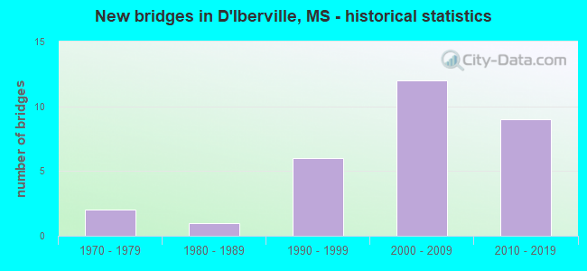
- New bridges - historical statistics
- 21970-1979
- 11980-1989
- 61990-1999
- 122000-2009
- 92010-2019


- Bridge Condition - Deck
- 26.7%Very good
- 46.7%Good
- 20.0%Satisfactory
- 6.7%Fair

- Bridge Condition - Superstructure
- 53.3%Very good
- 33.3%Good
- 6.7%Satisfactory
- 6.7%Fair

- Bridge Condition - Substructure
- 40.0%Very good
- 46.7%Good
- 13.3%Satisfactory

- Bridge Condition - Channel
- 9.1%Very good
- 45.5%Good
- 27.3%Satisfactory
- 9.1%Fair
- 9.1%Poor
Find on map >> Show street view
Structure Number: 31000150240046B, Location: 0.5 MI N I 10 (Lat: 30.459064, Lng: -88.899728), Route carried "on" structure: State highway 15, Year Built: 1977, Status: Open, Structure Length: 26.52m (87.01ft), Average Daily Traffic: 10,500 (year 2020), Truck Traffic: 6%, Average Future Daily Traffic: 10,500 (year 2040), Design Load: HS 20, Features Intersected: TCHOUTACABOUFFA RIVER
Minimum Vertical Clearance: 30+ m (98+ ft), Kilometerpoint: 0.657, Lanes on structure: 2, Base Highway Network: Yes (Inventory Route: 1, Subroute: 1), Owner: State Highway Agency, Approaching Roadway Width: 12.8m (42.0ft), Material/Design: Prestressed concrete continuous, Design/Construction: Stringer/Multi-beam, Number Of Spans In Main Unit: 5, Number Of Approach Spans: 10, Length of Maximum Span: 33.5m (109.9ft), Curb-To-Curb Width: 12.3m (40.4ft), Out-to-Out Width: 13.2m (43.3ft)
Condition: Deck: Good, Superstructure: Good, Substructure: Good, Channel: Satisfactory, Operating Rating: 65.3 metric tons, Method Used To Determine Operating Rating: Load Factor (LF), Inventory Rating: 36.6 metric tons, Method Used To Determine Inventory Rating: Load Factor (LF), Structural Evaluation: Better than present minimum criteria, Deck Geometry: Better than present minimum criteria, Waterway Adequacy: Equal to present desirable criteria, Approach Roadway Alignment: Equal to present desirable criteria, Designated Inspection Frequency: Every 24 months, Underwater Inspection Frequency: Every 60 months, Inspection Date: June 2021, Underwater Inspection Date: June 2019, Deck Structure Type: Concrete Cast-file-Place
Find on map >> Show street view
Structure Number: 31000670240066A, Location: SR 67 OVER SR 15 (Lat: 30.486211, Lng: -88.912669), Route carried "on" structure: State highway 67, Year Built: 2009, Status: Open, Structure Length: 9.27m (30.41ft), Average Daily Traffic: 6,000 (year 2020), Truck Traffic: 8%, Average Future Daily Traffic: 6,000 (year 2040), Design Load: HS 20, Features Intersected: SR 15
Minimum Vertical Clearance: 30+ m (98+ ft), Kilometerpoint: 28.979, Lanes on structure: 3, Lanes under structure: 2, Base Highway Network: Yes (Inventory Route: 6, Subroute: 1), Owner: State Highway Agency, Approaching Roadway Width: 15.6m (51.2ft), Material/Design: Prestressed concrete continuous, Design/Construction: Stringer/Multi-beam, Number Of Spans In Main Unit: 4, Length of Maximum Span: 27.0m (88.6ft), Curb-To-Curb Width: 15.6m (51.2ft), Out-to-Out Width: 16.5m (54.1ft)
Condition: Deck: Good, Superstructure: Very good, Substructure: Very good, Operating Rating: 53.3 metric tons, Method Used To Determine Operating Rating: Load Factor (LF), Inventory Rating: 25.3 metric tons, Method Used To Determine Inventory Rating: Load Factor (LF), Structural Evaluation: Equal to present minimum criteria, Deck Geometry: Equal to present minimum criteria, Underclear: Better than present minimum criteria, Approach Roadway Alignment: Equal to present desirable criteria, Designated Inspection Frequency: Every 24 months, Inspection Date: April 2021, Deck Structure Type: Concrete Cast-file-Place
Find on map >> Show street view
Structure Number: 31000670240066B, Location: SR 67 OVER SR 15 (Lat: 30.485478, Lng: -88.912203), Route carried "on" structure: State highway 67, Year Built: 2009, Status: Open, Structure Length: 9.27m (30.41ft), Average Daily Traffic: 6,000 (year 2020), Truck Traffic: 8%, Average Future Daily Traffic: 6,000 (year 2040), Design Load: HS 20, Features Intersected: SR 15
Minimum Vertical Clearance: 30+ m (98+ ft), Kilometerpoint: 0.164, Lanes on structure: 2, Lanes under structure: 2, Base Highway Network: Yes (Inventory Route: 6, Subroute: 1), Owner: State Highway Agency, Approaching Roadway Width: 12.0m (39.4ft), Material/Design: Prestressed concrete continuous, Design/Construction: Stringer/Multi-beam, Number Of Spans In Main Unit: 4, Length of Maximum Span: 27.0m (88.6ft), Curb-To-Curb Width: 12.0m (39.4ft), Out-to-Out Width: 12.9m (42.3ft)
Condition: Deck: Very good, Superstructure: Very good, Substructure: Very good, Operating Rating: 60.4 metric tons, Method Used To Determine Operating Rating: Load Factor (LF), Inventory Rating: 31.2 metric tons, Method Used To Determine Inventory Rating: Load Factor (LF), Structural Evaluation: Better than present minimum criteria, Deck Geometry: Better than present minimum criteria, Underclear: Superior to present desirable criteria, Approach Roadway Alignment: Equal to present desirable criteria, Designated Inspection Frequency: Every 24 months, Inspection Date: April 2021, Deck Structure Type: Concrete Cast-file-Place
Find on map >> Show street view
Structure Number: 41000100240486, Location: 0.3 MI E I 110 (Lat: 30.453022, Lng: -88.891658), Route carried "on" structure: County highway , Year Built: 2002, Status: Open, Structure Length: 18.47m (60.60ft), Average Daily Traffic: 7,500 (year 2020), Truck Traffic: 4%, Average Future Daily Traffic: 7,500 (year 2040), Design Load: HS 20, Features Intersected: I 10, Facility Carried by Structure: LAMEY BRIDGE ROAD
Minimum Vertical Clearance: 30+ m (98+ ft), Kilometerpoint: 2.055, Lanes on structure: 4, Lanes under structure: 10, Owner: State Highway Agency, Approaching Roadway Width: 17.1m (56.1ft), Material/Design: Steel continuous, Design/Construction: Box Beam or Girders - Multiple, Number Of Spans In Main Unit: 4, Length of Maximum Span: 57.3m (188.0ft), Curb-To-Curb Width: 17.1m (56.1ft), Out-to-Out Width: 17.9m (58.7ft)
Condition: Deck: Very good, Superstructure: Very good, Substructure: Very good, Operating Rating: 80.0 metric tons, Method Used To Determine Operating Rating: Load Factor (LF), Inventory Rating: 47.9 metric tons, Method Used To Determine Inventory Rating: Load Factor (LF), Structural Evaluation: Equal to present desirable criteria, Deck Geometry: Somewhat better than minimum adequacy, Underclear: Equal to present desirable criteria, Approach Roadway Alignment: Equal to present desirable criteria, Designated Inspection Frequency: Every 24 months, Inspection Date: November 2021, Deck Structure Type: Concrete Cast-file-Place
Find on map >> Show street view
Structure Number: 5100010024048, Location: 0.5 MI W I 110 (Lat: 30.450208, Lng: -88.903303), Route carried "on" structure: City street 10, Year Built: 2015, Status: Open, Structure Length: 15.31m (50.23ft), Average Daily Traffic: 6,900 (year 2020), Truck Traffic: 6%, Average Future Daily Traffic: 6,900 (year 2040), Design Load: HL 93, Features Intersected: I 10, Facility Carried by Structure: D'IBERVILLE BLVD
Minimum Vertical Clearance: 30+ m (98+ ft), Kilometerpoint: 2.152, Lanes on structure: 4, Lanes under structure: 9, Owner: State Highway Agency, Approaching Roadway Width: 23.2m (76.1ft), Skew: 21 degrees, Material/Design: Prestressed concrete continuous, Design/Construction: Stringer/Multi-beam, Number Of Spans In Main Unit: 4, Length of Maximum Span: 38.1m (125.0ft), Curb-To-Curb Width: 23.2m (76.1ft), Out-to-Out Width: 24.0m (78.7ft)
Condition: Deck: Very good, Superstructure: Very good, Substructure: Very good, Operating Rating: 47.3 metric tons, Method Used To Determine Operating Rating: Load and Resistance Factor (LRFR), Inventory Rating: 36.5 metric tons, Method Used To Determine Inventory Rating: Load and Resistance Factor (LRFR), Structural Evaluation: Equal to present desirable criteria, Deck Geometry: Superior to present desirable criteria, Underclear: Better than present minimum criteria, Approach Roadway Alignment: Equal to present desirable criteria, Designated Inspection Frequency: Every 24 months, Inspection Date: November 2021, Deck Structure Type: Concrete Cast-file-Place
Find on map >> Show street view
Structure Number: 51000150240045, Location: 0.4 MI N I 10 (Lat: 30.458069, Lng: -88.898511), Route carried "on" structure: City street 15, Year Built: 2013, Status: Open, Structure Length: 8.91m (29.23ft), Average Daily Traffic: 15,000 (year 2020), Truck Traffic: 5%, Average Future Daily Traffic: 15,000 (year 2040), Design Load: HL 93, Features Intersected: SR 15/SR 67, Facility Carried by Structure: SANGANI BLVD
Minimum Vertical Clearance: 30+ m (98+ ft), Kilometerpoint: 0.103, Lanes on structure: 5, Lanes under structure: 8, Owner: State Highway Agency, Approaching Roadway Width: 23.2m (76.1ft), Material/Design: Prestressed concrete continuous, Design/Construction: Stringer/Multi-beam, Number Of Spans In Main Unit: 4, Length of Maximum Span: 25.9m (85.0ft), Curb or Sidewalk Widths: Left: 0.0m, Right: 1.5m (4.9ft), Curb-To-Curb Width: 23.2m (76.1ft), Out-to-Out Width: 25.8m (84.6ft)
Condition: Deck: Good, Superstructure: Very good, Substructure: Very good, Operating Rating: 50.6 metric tons, Method Used To Determine Operating Rating: Load and Resistance Factor (LRFR), Inventory Rating: 38.9 metric tons, Method Used To Determine Inventory Rating: Load and Resistance Factor (LRFR), Structural Evaluation: Equal to present desirable criteria, Deck Geometry: Better than present minimum criteria, Underclear: Somewhat better than minimum adequacy, Approach Roadway Alignment: Equal to present desirable criteria, Designated Inspection Frequency: Every 24 months, Inspection Date: December 2021, Deck Structure Type: Concrete Cast-file-Place
Find on map >> Show street view
Structure Number: SA2400000000041, Location: SEC 20 T 6S R 9W (Lat: 30.509444, Lng: -88.911667), Route carried "on" structure: County highway 8128, Year Built: 2002, Status: Open, Structure Length: 7.33m (24.05ft), Average Daily Traffic: 700 (year 2009), Truck Traffic: 8%, Average Future Daily Traffic: 1,100 (year 2030), Design Load: HS 20, Features Intersected: TUXACHANIE CREEK, Facility Carried by Structure: OLD HWY 15
Minimum Vertical Clearance: 30+ m (98+ ft), Kilometerpoint: 0.321, Lanes on structure: 2, Owner: County Highway Agency, Approaching Roadway Width: 10.3m (33.8ft), Material/Design: Prestressed concrete, Design/Construction: Stringer/Multi-beam, Number Of Spans In Main Unit: 1, Number Of Approach Spans: 4, Length of Maximum Span: 30.4m (99.7ft), Curb or Sidewalk Widths: Left: 0.3m (1.0ft), Right: 0.3m (1.0ft), Curb-To-Curb Width: 8.5m (27.9ft), Out-to-Out Width: 9.1m (29.9ft)
Condition: Deck: Good, Superstructure: Good, Substructure: Good, Channel: Satisfactory, Operating Rating: 58.8 metric tons, Method Used To Determine Operating Rating: Load Factor (LF), Inventory Rating: 19.6 metric tons, Method Used To Determine Inventory Rating: Load Factor (LF), Structural Evaluation: Somewhat better than minimum adequacy, Deck Geometry: Somewhat better than minimum adequacy, Waterway Adequacy: Equal to present desirable criteria, Approach Roadway Alignment: Equal to present minimum criteria, Designated Inspection Frequency: Every 24 months, Inspection Date: Febuary 2021, Deck Structure Type: Concrete Cast-file-Place, Wearing Surface/Protective System: Wearing Surface: Monolithic Concrete
Find on map >> Show street view
Structure Number: SA2400000000042, Location: SEC 33 T 6S R 9W B (Lat: 30.475919, Lng: -88.893264), Route carried "on" structure: County highway 139, Year Built: 1970, Status: Posted for load, Structure Length: 10.06m (33.01ft), Average Daily Traffic: 7,100 (year 2019), Truck Traffic: 8%, Average Future Daily Traffic: 7,810 (year 2039), Design Load: HS 15, Features Intersected: TCHOUTACABOUFFA RIVER
Minimum Vertical Clearance: 30+ m (98+ ft), Kilometerpoint: 22.530, Lanes on structure: 2, Owner: City or Municipal Highway Agency, Approaching Roadway Width: 12.2m (40.0ft), Navigation Control: Yes ( Vertical Clearance: 3.9m (12.8ft), Horizontal Clearance: 24.3m (79.7ft)), Material/Design: Steel, Design/Construction: Stringer/Multi-beam, Number Of Spans In Main Unit: 6, Length of Maximum Span: 27.4m (89.9ft), Curb-To-Curb Width: 7.3m (24.0ft), Out-to-Out Width: 8.7m (28.5ft)
Condition: Deck: Fair, Superstructure: Fair, Substructure: Satisfactory, Channel: Poor, Operating Rating: 23.0 metric tons, Method Used To Determine Operating Rating: Load Factor (LF) rating reported by rating factor (RF) method using MS18 loading, Inventory Rating: 13.9 metric tons, Method Used To Determine Inventory Rating: Load Factor (LF) rating reported by rating factor (RF) method using MS18 loading, Structural Evaluation: High priority of replacement, Deck Geometry: High priority of replacement, Waterway Adequacy: Equal to present desirable criteria, Approach Roadway Alignment: Equal to present minimum criteria, Bridge Posting: Required (Relationship of Operating Rating to Maximum Legal Load: 30.0 - 39.9% below), Length Of Structure Improvement: 10.00m (32.81ft), Designated Inspection Frequency: Every 24 months, Underwater Inspection Frequency: Every 60 months, Inspection Date: December 2019, Underwater Inspection Date: September 2020, Bridge Improvement Cost: $150,000, Roadway Improvement Cost: $10,000, Total Project Cost: $200,000, Deck Structure Type: Concrete Cast-file-Place, Wearing Surface/Protective System: Wearing Surface: Monolithic Concrete
Find on map >> Show street view
Structure Number: SA2400000000043, Location: SEC 33 T 6S R 9W B (Lat: 30.475556, Lng: -88.893056), Route carried "on" structure: County highway 139, Year Built: 1991, Status: Posted for load, Structure Length: 2.68m (8.79ft), Average Daily Traffic: 3,200 (year 2009), Truck Traffic: 8%, Average Future Daily Traffic: 4,700 (year 2030), Design Load: HS 20, Features Intersected: TCHOUTACABOUFFA RELIEF
Minimum Vertical Clearance: 30+ m (98+ ft), Kilometerpoint: 22.691, Lanes on structure: 2, Owner: City or Municipal Highway Agency, Approaching Roadway Width: 11.0m (36.1ft), Material/Design: Concrete, Design/Construction: Channel Beam, Number Of Spans In Main Unit: 4, Length of Maximum Span: 9.4m (30.8ft), Curb or Sidewalk Widths: Left: 0.2m (0.7ft), Right: 0.2m (0.7ft), Curb-To-Curb Width: 8.1m (26.6ft), Out-to-Out Width: 8.9m (29.2ft)
Condition: Deck: Good, Superstructure: Good, Substructure: Good, Channel: Satisfactory, Operating Rating: 74.8 metric tons, Method Used To Determine Operating Rating: Load Factor (LF) rating reported by rating factor (RF) method using MS18 loading, Inventory Rating: 45.0 metric tons, Method Used To Determine Inventory Rating: Load Factor (LF) rating reported by rating factor (RF) method using MS18 loading, Structural Evaluation: Better than present minimum criteria, Deck Geometry: High priority of corrective action, Waterway Adequacy: Somewhat better than minimum adequacy, Approach Roadway Alignment: Better than present minimum criteria, Length Of Structure Improvement: 2.68m (8.79ft), Designated Inspection Frequency: Every 24 months, Inspection Date: November 2020, Bridge Improvement Cost: $2,000, Roadway Improvement Cost: $1,000, Total Project Cost: $3,000, Deck Structure Type: Concrete Precast Panels, Wearing Surface/Protective System: Wearing Surface: Monolithic Concrete
Find on map >> Show street view
Structure Number: SA2400000000073, Location: SEC 4 T 7S R 9W B (Lat: 30.461667, Lng: -88.891667), Route carried "on" structure: County highway 139, Year Built: 1994, Status: Open, Structure Length: 6.95m (22.80ft), Average Daily Traffic: 4,000 (year 2012), Truck Traffic: 8%, Average Future Daily Traffic: 6,000 (year 2032), Design Load: HS 20, Features Intersected: CYPRESS CREEK
Minimum Vertical Clearance: 30+ m (98+ ft), Kilometerpoint: 24.140, Lanes on structure: 2, Owner: City or Municipal Highway Agency, Approaching Roadway Width: 11.0m (36.1ft), Material/Design: Concrete, Design/Construction: Channel Beam, Number Of Spans In Main Unit: 12, Length of Maximum Span: 5.8m (19.0ft), Curb or Sidewalk Widths: Left: 0.4m (1.3ft), Right: 0.4m (1.3ft), Curb-To-Curb Width: 9.2m (30.2ft), Out-to-Out Width: 10.0m (32.8ft)
Condition: Deck: Satisfactory, Superstructure: Good, Substructure: Good, Channel: Good, Operating Rating: 70.6 metric tons, Method Used To Determine Operating Rating: Load Factor (LF), Inventory Rating: 42.2 metric tons, Method Used To Determine Inventory Rating: Load Factor (LF), Structural Evaluation: Better than present minimum criteria, Deck Geometry: Meets minimum limits, Waterway Adequacy: Superior to present desirable criteria, Approach Roadway Alignment: Equal to present desirable criteria, Designated Inspection Frequency: Every 24 months, Inspection Date: December 2021, Deck Structure Type: Concrete Precast Panels
Find on map >> Show street view
Structure Number: SA2400000000074, Location: SEC 5 T 7S R 9W B (Lat: 30.459444, Lng: -88.908611), Route carried "on" structure: County highway 17, Year Built: 1998, Status: Open, Structure Length: 12.80m (41.99ft), Average Daily Traffic: 3,500 (year 2012), Truck Traffic: 8%, Average Future Daily Traffic: 5,000 (year 2032), Design Load: HS 20, Features Intersected: TCHOUTACABOUFFA RIVER, Facility Carried by Structure: OLD HWY 15
Minimum Vertical Clearance: 30+ m (98+ ft), Kilometerpoint: 3.379, Lanes on structure: 2, Owner: County Highway Agency, Approaching Roadway Width: 11.0m (36.1ft), Navigation Control: Yes ( Vertical Clearance: 9.6m (31.5ft), Horizontal Clearance: 27.7m (90.9ft)), Material/Design: Prestressed concrete, Design/Construction: Stringer/Multi-beam, Number Of Spans In Main Unit: 6, Length of Maximum Span: 30.5m (100.1ft), Curb-To-Curb Width: 10.9m (35.8ft), Out-to-Out Width: 11.8m (38.7ft)
Condition: Deck: Satisfactory, Superstructure: Very good, Substructure: Good, Channel: Good, Operating Rating: 46.1 metric tons, Method Used To Determine Operating Rating: Load Factor (LF), Inventory Rating: 25.2 metric tons, Method Used To Determine Inventory Rating: Load Factor (LF), Structural Evaluation: Equal to present minimum criteria, Deck Geometry: Somewhat better than minimum adequacy, Waterway Adequacy: Superior to present desirable criteria, Approach Roadway Alignment: Better than present minimum criteria, Designated Inspection Frequency: Every 24 months, Inspection Date: April 2021, Deck Structure Type: Concrete Cast-file-Place, Wearing Surface/Protective System: Wearing Surface: Monolithic Concrete
Find on map >> Show street view
Structure Number: SA2400000000076, Location: SEC 21 T 7S R 9W (Lat: 30.433611, Lng: -88.887778), Route carried "on" structure: City street 495, Year Built: 2010, Status: Open, Structure Length: 1.04m (3.41ft), Average Daily Traffic: 6,000 (year 2010), Truck Traffic: 8%, Average Future Daily Traffic: 9,000 (year 2030), Design Load: HS 20+Mod, Features Intersected: ST MARTINS BAYOU BRANCH, Facility Carried by Structure: GORENFLO AVE
Minimum Vertical Clearance: 30+ m (98+ ft), Kilometerpoint: 0.804, Lanes on structure: 2, Owner: City or Municipal Highway Agency, Approaching Roadway Width: 8.5m (27.9ft), Material/Design: Concrete, Design/Construction: Culvert, Number Of Spans In Main Unit: 2, Length of Maximum Span: 5.2m (17.1ft)
Condition: Channel: Very good, Culverts: Good, Operating Rating: 43.2 metric tons, Method Used To Determine Operating Rating: Allowable Stress (AS), Inventory Rating: 32.4 metric tons, Method Used To Determine Inventory Rating: Allowable Stress (AS), Structural Evaluation: Better than present minimum criteria, Waterway Adequacy: Equal to present desirable criteria, Approach Roadway Alignment: Equal to present desirable criteria, Designated Inspection Frequency: Every 24 months, Inspection Date: May 2021
Find on map >> Show street view
Structure Number: SA2400000000077, Location: SEC 22 T 7S R 9W (Lat: 30.433636, Lng: -88.890158), Route carried "on" structure: City street 481, Year Built: 1982, Status: Open, Structure Length: 0.94m (3.08ft), Average Daily Traffic: 50 (year 2020), Average Future Daily Traffic: 75 (year 2040), Design Load: HS 20, Features Intersected: ST MARTINS BAYOU BRANCH, Facility Carried by Structure: CHURCH AVE
Minimum Vertical Clearance: 30+ m (98+ ft), Kilometerpoint: 0.804, Lanes on structure: 2, Owner: City or Municipal Highway Agency, Approaching Roadway Width: 9.4m (30.8ft), Material/Design: Concrete, Design/Construction: Channel Beam, Number Of Spans In Main Unit: 1, Length of Maximum Span: 9.4m (30.8ft), Curb or Sidewalk Widths: Left: 0.2m (0.7ft), Right: 0.2m (0.7ft), Curb-To-Curb Width: 7.2m (23.6ft), Out-to-Out Width: 7.6m (24.9ft)
Condition: Deck: Satisfactory, Superstructure: Satisfactory, Substructure: Satisfactory, Channel: Fair, Operating Rating: 59.2 metric tons, Method Used To Determine Operating Rating: Load Factor (LF), Inventory Rating: 35.5 metric tons, Method Used To Determine Inventory Rating: Load Factor (LF), Structural Evaluation: Equal to present minimum criteria, Deck Geometry: Somewhat better than minimum adequacy, Waterway Adequacy: Equal to present desirable criteria, Approach Roadway Alignment: Equal to present desirable criteria, Length Of Structure Improvement: 0.94m (3.08ft), Designated Inspection Frequency: Every 24 months, Inspection Date: December 2020, Bridge Improvement Cost: $2,000, Roadway Improvement Cost: $1,000, Total Project Cost: $3,000, Deck Structure Type: Concrete Precast Panels, Wearing Surface/Protective System: Wearing Surface: Monolithic Concrete
Find on map >> Show street view
Structure Number: SA2400000000175, Location: SEC 23 T 7S R 9W (Lat: 30.431944, Lng: -88.902500), Route carried "on" structure: City street 4473, Year Built: 1996, Status: Open, Structure Length: 0.95m (3.12ft), Average Daily Traffic: 3,000 (year 2010), Truck Traffic: 8%, Average Future Daily Traffic: 4,500 (year 2032), Features Intersected: RAVINE CANNE, Facility Carried by Structure: BRODIE RD
Minimum Vertical Clearance: 30+ m (98+ ft), Kilometerpoint: 3.060, Lanes on structure: 2, Owner: City or Municipal Highway Agency, Approaching Roadway Width: 10.4m (34.1ft), Material/Design: Concrete, Design/Construction: Channel Beam, Number Of Spans In Main Unit: 1, Length of Maximum Span: 9.5m (31.2ft), Curb-To-Curb Width: 8.1m (26.6ft), Out-to-Out Width: 8.5m (27.9ft)
Condition: Deck: Good, Superstructure: Good, Substructure: Good, Channel: Good, Operating Rating: 53.9 metric tons, Method Used To Determine Operating Rating: Load Factor (LF), Inventory Rating: 32.4 metric tons, Method Used To Determine Inventory Rating: Load Factor (LF), Structural Evaluation: Better than present minimum criteria, Deck Geometry: High priority of corrective action, Waterway Adequacy: Superior to present desirable criteria, Approach Roadway Alignment: Better than present minimum criteria, Designated Inspection Frequency: Every 24 months, Inspection Date: November 2021, Deck Structure Type: Concrete Precast Panels
Find on map >> Show street view
Structure Number: SA2400000000176, Location: SEC 23 T 7S R 9W (Lat: 30.435000, Lng: -88.902222), Route carried "on" structure: City street 910, Year Built: 1996, Status: Open, Structure Length: 0.95m (3.12ft), Average Daily Traffic: 600 (year 2012), Truck Traffic: 7%, Average Future Daily Traffic: 900 (year 2032), Design Load: HS 20, Features Intersected: FOREST COVE EAST CANAL, Facility Carried by Structure: GINGER DR
Minimum Vertical Clearance: 30+ m (98+ ft), Kilometerpoint: 0.320, Lanes on structure: 2, Owner: City or Municipal Highway Agency, Approaching Roadway Width: 9.2m (30.2ft), Material/Design: Concrete, Design/Construction: Channel Beam, Number Of Spans In Main Unit: 1, Length of Maximum Span: 9.5m (31.2ft), Curb-To-Curb Width: 8.1m (26.6ft), Out-to-Out Width: 8.5m (27.9ft)
Condition: Deck: Good, Superstructure: Very good, Substructure: Good, Channel: Good, Operating Rating: 53.9 metric tons, Method Used To Determine Operating Rating: Load Factor (LF), Inventory Rating: 32.4 metric tons, Method Used To Determine Inventory Rating: Load Factor (LF), Structural Evaluation: Better than present minimum criteria, Deck Geometry: Somewhat better than minimum adequacy, Waterway Adequacy: Better than present minimum criteria, Approach Roadway Alignment: Equal to present desirable criteria, Designated Inspection Frequency: Every 24 months, Inspection Date: November 2021, Deck Structure Type: Concrete Precast Panels
Find on map >> Show street view
Structure Number: SA2400000000179, Location: SEC 23 T 7S R 9W (Lat: 30.435278, Lng: -88.915833), Route carried "on" structure: City street 4473, Year Built: 1997, Status: Open, Structure Length: 0.95m (3.12ft), Average Daily Traffic: 3,000 (year 2012), Truck Traffic: 8%, Average Future Daily Traffic: 4,500 (year 2032), Design Load: HS 20, Features Intersected: DIBERVILLE CANAL, Facility Carried by Structure: BRODIE ROAD
Minimum Vertical Clearance: 30+ m (98+ ft), Kilometerpoint: 1.931, Lanes on structure: 2, Owner: City or Municipal Highway Agency, Approaching Roadway Width: 10.4m (34.1ft), Material/Design: Concrete, Design/Construction: Channel Beam, Number Of Spans In Main Unit: 1, Length of Maximum Span: 9.5m (31.2ft), Curb-To-Curb Width: 8.1m (26.6ft), Out-to-Out Width: 8.5m (27.9ft)
Condition: Deck: Very good, Superstructure: Very good, Substructure: Very good, Channel: Good, Operating Rating: 53.9 metric tons, Method Used To Determine Operating Rating: Load Factor (LF), Inventory Rating: 32.4 metric tons, Method Used To Determine Inventory Rating: Load Factor (LF), Structural Evaluation: Equal to present desirable criteria, Deck Geometry: High priority of corrective action, Waterway Adequacy: Superior to present desirable criteria, Approach Roadway Alignment: Equal to present desirable criteria, Length Of Structure Improvement: 0.10m (0.33ft), Designated Inspection Frequency: Every 24 months, Inspection Date: November 2021, Bridge Improvement Cost: $1,000, Roadway Improvement Cost: $1,000, Total Project Cost: $2,000, Deck Structure Type: Concrete Precast Panels
Find on map >> Show street view
Structure Number: 31000670240066A, Location: SR 67 OVER SR 15 (Lat: 30.485739, Lng: -88.912569), Route carried "under" structure: State highway 15, Year Built: 2009, Structure Length: 0. m, Average Daily Traffic: 3,500 (year 2017), Truck Traffic: 8%, Features Intersected: SR 15, Facility Carried by Structure: SR 67
Minimum Vertical Clearance: 4.96m (16.27ft), Kilometerpoint: 0.447, Lanes on structure: 3, Lanes under structure: 2, Material/Design: Prestressed concrete continuous, Design/Construction: Stringer/Multi-beam, Length of Maximum Span: 27.1m (88.9ft)
Find on map >> Show street view
Structure Number: 31000670240066A, Location: SR 67 OVER SR 15 (Lat: 30.485939, Lng: -88.912619), Route carried "under" structure: State highway 15, Year Built: 2009, Structure Length: 0. m, Average Daily Traffic: 3,500 (year 2017), Truck Traffic: 8%, Features Intersected: SR 15, Facility Carried by Structure: SR 67
Minimum Vertical Clearance: 5.05m (16.57ft), Kilometerpoint: 0.217, Lanes on structure: 3, Lanes under structure: 2, Material/Design: Prestressed concrete continuous, Design/Construction: Stringer/Multi-beam, Length of Maximum Span: 27.1m (88.9ft)
Find on map >> Show street view
Structure Number: 31000670240066B, Location: SR 67 OVER SR 15 (Lat: 30.486011, Lng: -88.912339), Route carried "under" structure: State highway 15, Year Built: 2009, Structure Length: 0. m, Average Daily Traffic: 3,300 (year 2017), Truck Traffic: 8%, Features Intersected: SR 15, Facility Carried by Structure: SR 67
Minimum Vertical Clearance: 5.23m (17.16ft), Kilometerpoint: 0.190, Lanes on structure: 2, Lanes under structure: 2, Material/Design: Prestressed concrete continuous, Design/Construction: Stringer/Multi-beam, Length of Maximum Span: 27.1m (88.9ft)
Find on map >> Show street view
Structure Number: 31000670240066B, Location: SR 67 OVER SR 15 (Lat: 30.485811, Lng: -88.912289), Route carried "under" structure: State highway 15, Year Built: 2009, Structure Length: 0. m, Average Daily Traffic: 3,300 (year 2017), Truck Traffic: 8%, Features Intersected: SR 15, Facility Carried by Structure: SR 67
Minimum Vertical Clearance: 5.12m (16.80ft), Kilometerpoint: 0.476, Lanes on structure: 2, Lanes under structure: 2, Material/Design: Prestressed concrete continuous, Design/Construction: Stringer/Multi-beam, Length of Maximum Span: 27.1m (88.9ft)
Find on map >> Show street view
Structure Number: 41000100240486, Location: 0.3 MI E I 110 (Lat: 30.453989, Lng: -88.891661), Route carried "under" structure: Interstate 10, Year Built: 2002, Structure Length: 0. m, Average Daily Traffic: 38,000 (year 2018), Truck Traffic: 10%, Features Intersected: I 10, Facility Carried by Structure: LAMEY BRIDGE ROAD
Minimum Vertical Clearance: 5.63m (18.47ft), Kilometerpoint: 0.798, Lanes on structure: 3, Lanes under structure: 4, Material/Design: Steel continuous, Design/Construction: Box Beam or Girders - Multiple, Length of Maximum Span: 57.3m (188.0ft)
Find on map >> Show street view
Structure Number: 41000100240486, Location: 0.3 MI E I 110 (Lat: 30.453689, Lng: -88.891661), Route carried "under" structure: Interstate 10, Year Built: 2002, Structure Length: 0. m, Average Daily Traffic: 38,000 (year 2018), Truck Traffic: 10%, Features Intersected: I 10, Facility Carried by Structure: LAMEY BRIDGE ROAD
Minimum Vertical Clearance: 5.51m (18.08ft), Kilometerpoint: 45.174, Lanes on structure: 3, Lanes under structure: 4, Material/Design: Steel continuous, Design/Construction: Box Beam or Girders - Multiple, Length of Maximum Span: 57.3m (188.0ft)
Find on map >> Show street view
Structure Number: 41000100240486, Location: 0.3 MI E I 110 (Lat: 30.454219, Lng: -88.891661), Route carried "under" structure: Ramp Interstate 10, Year Built: 2002, Structure Length: 0. m, Average Daily Traffic: 18,000 (year 2018), Truck Traffic: 10%, Features Intersected: I 10, Facility Carried by Structure: LAMEY BRIDGE ROAD
Minimum Vertical Clearance: 5.65m (18.54ft), Kilometerpoint: 0.293, Lanes on structure: 1, Lanes under structure: 4, Material/Design: Steel continuous, Design/Construction: Box Beam or Girders - Multiple, Length of Maximum Span: 57.3m (188.0ft)
Find on map >> Show street view
Structure Number: 41000100240486, Location: 0.3 MI E I 110 (Lat: 30.453469, Lng: -88.891650), Route carried "under" structure: Ramp Interstate 10, Year Built: 2002, Structure Length: 0. m, Average Daily Traffic: 5,700 (year 2018), Truck Traffic: 10%, Features Intersected: I 10, Facility Carried by Structure: LAMEY BRIDGE ROAD
Minimum Vertical Clearance: 6.02m (19.75ft), Kilometerpoint: 0.488, Lanes on structure: 1, Lanes under structure: 4, Material/Design: Steel continuous, Design/Construction: Box Beam or Girders - Multiple, Length of Maximum Span: 57.3m (188.0ft)
Find on map >> Show street view
Structure Number: 5100010024048, Location: 0.5 MI W I 110 (Lat: 30.450889, Lng: -88.903961), Route carried "under" structure: ServiceInterstate 10, Year Built: 2015, Structure Length: 0. m, Average Daily Traffic: 5,900 (year 2018), Truck Traffic: 5%, Features Intersected: I 10, Facility Carried by Structure: D'IBERVILLE BLVD
Minimum Vertical Clearance: 5.15m (16.90ft), Kilometerpoint: 2.037, Lanes on structure: 4, Lanes under structure: 9, Material/Design: Prestressed concrete continuous, Design/Construction: Stringer/Multi-beam, Length of Maximum Span: 38.1m (125.0ft)
Find on map >> Show street view
Structure Number: 5100010024048, Location: 0.5 MI W I 110 (Lat: 30.450569, Lng: -88.903689), Route carried "under" structure: Interstate 10, Year Built: 2015, Structure Length: 0. m, Average Daily Traffic: 36,500 (year 2018), Truck Traffic: 5%, Features Intersected: I 10, Facility Carried by Structure: D'IBERVILLE BLVD
Minimum Vertical Clearance: 5.38m (17.65ft), Kilometerpoint: 43.961, Lanes on structure: 4, Lanes under structure: 9, Material/Design: Prestressed concrete continuous, Design/Construction: Stringer/Multi-beam, Length of Maximum Span: 38.1m (125.0ft)
Find on map >> Show street view
Structure Number: 5100010024048, Location: 0.5 MI W I 110 (Lat: 30.451111, Lng: -88.904150), Route carried "under" structure: Interstate 10, Year Built: 2015, Structure Length: 0. m, Average Daily Traffic: 36,500 (year 2018), Truck Traffic: 5%, Features Intersected: I 10, Facility Carried by Structure: D'IBERVILLE BLVD
Minimum Vertical Clearance: 5.27m (17.29ft), Kilometerpoint: 1.548, Lanes on structure: 4, Lanes under structure: 9, Material/Design: Prestressed concrete continuous, Design/Construction: Stringer/Multi-beam, Length of Maximum Span: 38.1m (125.0ft)
Find on map >> Show street view
Structure Number: 5100010024048, Location: 0.5 MI W I 110 (Lat: 30.450369, Lng: -88.903511), Route carried "under" structure: ServiceInterstate 10, Year Built: 2015, Structure Length: 0. m, Average Daily Traffic: 5,700 (year 2018), Truck Traffic: 5%, Features Intersected: I 10, Facility Carried by Structure: D'IBERVILLE BLVD
Minimum Vertical Clearance: 5.29m (17.36ft), Kilometerpoint: 0.628, Lanes on structure: 4, Lanes under structure: 9, Material/Design: Prestressed concrete continuous, Design/Construction: Stringer/Multi-beam, Length of Maximum Span: 38.1m (125.0ft)
Find on map >> Show street view
Structure Number: 51000150240045, Location: 0.4 MI N I 10 (Lat: 30.457881, Lng: -88.898831), Route carried "under" structure: State highway 15, Year Built: 2013, Structure Length: 0. m, Average Daily Traffic: 9,500 (year 2018), Truck Traffic: 8%, Features Intersected: SR 15/SR 67, Facility Carried by Structure: SANGANI BLVD
Minimum Vertical Clearance: 5.16m (16.93ft), Kilometerpoint: 0.501, Lanes on structure: 4, Lanes under structure: 8, Material/Design: Prestressed concrete continuous, Design/Construction: Stringer/Multi-beam, Length of Maximum Span: 25.9m (85.0ft)
Find on map >> Show street view
Structure Number: 51000150240045, Location: 0.4 MI N I 10 (Lat: 30.457781, Lng: -88.899011), Route carried "under" structure: State highway 15, Year Built: 2013, Structure Length: 0. m, Average Daily Traffic: 9,500 (year 2018), Truck Traffic: 8%, Features Intersected: SR 15/SR 67, Facility Carried by Structure: SANGANI BLVD
Minimum Vertical Clearance: 5.20m (17.06ft), Kilometerpoint: 3.619, Lanes on structure: 4, Lanes under structure: 8, Material/Design: Prestressed concrete continuous, Design/Construction: Stringer/Multi-beam, Length of Maximum Span: 25.9m (85.0ft)