Bridge Statistics for Culver City, California (CA)
Condition, Traffic, Stress, Structural Evaluation, Project Costs
- National Bridge Inventory (NBI) Statistics
- 49Number of bridges
- 879ft / 268mTotal length
- 4,757,558Total average daily traffic
- 220,578Total average daily truck traffic
- National Bridge Inventory (NBI) Registered Bridges for Culver City
- No street view available for this location
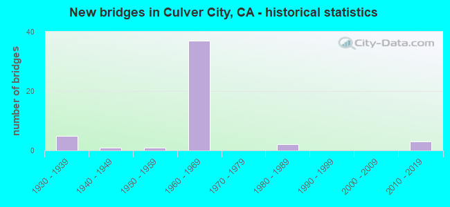
- New bridges - historical statistics
- 51930-1939
- 11940-1949
- 11950-1959
- 371960-1969
- 21980-1989
- 32010-2019

- Reconstructed bridges - Historical Statistics
- 11960-1969
- 01970-1979
- 01980-1989
- 01990-1999
- 72000-2009


- Bridge Condition - Deck
- 86.4%Good
- 4.5%Satisfactory
- 9.1%Fair

- Bridge Condition - Superstructure
- 4.5%Very good
- 77.3%Good
- 9.1%Satisfactory
- 9.1%Fair

- Bridge Condition - Culverts
- 25.0%Very good
- 75.0%Good
Find on map >> Show street view
Structure Number: 53 1252, Location: 07-LA-405-25.54-CLC (Lat: 33.983125, Lng: -118.395172), Route carried "on" structure: Interstate 405, Year Built: 1963, Status: Open, Structure Length: 2.23m (7.32ft), Average Daily Traffic: 294,000 (year 2014), Truck Traffic: 4%, Average Future Daily Traffic: 414,167 (year 2043), Design Load: HS 20, Features Intersected: CENTINELA CREEK
Minimum Vertical Clearance: 30+ m (98+ ft), Kilometerpoint: 25.540, Lanes on structure: 9, Base Highway Network: Yes (Inventory Route: 4, Subroute: 1), Owner: State Highway Agency, Approaching Roadway Width: 17.7m (58.1ft), Skew: 9 degrees, Material/Design: Concrete continuous, Design/Construction: Culvert, Number Of Spans In Main Unit: 4, Length of Maximum Span: 6.1m (20.0ft), Curb-To-Curb Width: 17.7m (58.1ft), Out-to-Out Width: 17.7m (58.1ft)
Condition: Channel: Very good, Culverts: Good, Operating Rating: 54.1 metric tons, Method Used To Determine Operating Rating: Field evaluation and documented engineering judgment, Inventory Rating: 32.4 metric tons, Method Used To Determine Inventory Rating: Field evaluation and documented engineering judgment, Structural Evaluation: Better than present minimum criteria, Deck Geometry: High priority of replacement, Waterway Adequacy: Equal to present desirable criteria, Approach Roadway Alignment: Equal to present desirable criteria, Designated Inspection Frequency: Every 24 months, Inspection Date: Febuary 2021
Find on map >> Show street view
Structure Number: 53 1254, Location: 07-LA-405-25.46-CLC (Lat: 33.982147, Lng: -118.394331), Route carried "on" structure: Interstate 405, Year Built: 1963, Year Reconstructed: 2014, Status: Open, Structure Length: 7.55m (24.77ft), Average Daily Traffic: 284,000 (year 2019), Truck Traffic: 4%, Average Future Daily Traffic: 341,091 (year 2038), Design Load: HS 20, Features Intersected: SEPULVEDA BLVD
Minimum Vertical Clearance: 30+ m (98+ ft), Kilometerpoint: 25.460, Lanes on structure: 11, Lanes under structure: 6, Base Highway Network: Yes (Inventory Route: 4, Subroute: 1), Owner: State Highway Agency, Approaching Roadway Width: 48.9m (160.4ft), Skew: 34 degrees, Material/Design: Concrete continuous, Design/Construction: Box Beam or Girders - Multiple, Number Of Spans In Main Unit: 4, Length of Maximum Span: 21.6m (70.9ft), Curb-To-Curb Width: 48.9m (160.4ft), Out-to-Out Width: 49.9m (163.7ft)
Condition: Deck: Satisfactory, Superstructure: Good, Substructure: Good, Operating Rating: 73.4 metric tons, Method Used To Determine Operating Rating: Load Factor (LF), Inventory Rating: 43.5 metric tons, Method Used To Determine Inventory Rating: Load Factor (LF), Structural Evaluation: Better than present minimum criteria, Deck Geometry: Superior to present desirable criteria, Underclear: High priority of corrective action, Approach Roadway Alignment: Superior to present desirable criteria, Designated Inspection Frequency: Every 24 months, Inspection Date: Febuary 2021, Deck Structure Type: Concrete Cast-file-Place
Find on map >> Show street view
Structure Number: 53 1256, Location: 07-LA-405-26.49-CLC (Lat: 33.994536, Lng: -118.404067), Route carried "on" structure: Interstate 405, Year Built: 1960, Year Reconstructed: 2009, Status: Open, Structure Length: 7.50m (24.61ft), Average Daily Traffic: 278,000 (year 2014), Truck Traffic: 4%, Average Future Daily Traffic: 424,622 (year 2043), Design Load: HS 20, Features Intersected: BALLONA CREEK
Minimum Vertical Clearance: 30+ m (98+ ft), Kilometerpoint: 26.490, Lanes on structure: 13, Base Highway Network: Yes (Inventory Route: 4, Subroute: 1), Owner: State Highway Agency, Approaching Roadway Width: 61.0m (200.1ft), Skew: 31 degrees, Material/Design: Concrete continuous, Design/Construction: Box Beam or Girders - Multiple, Number Of Spans In Main Unit: 3, Length of Maximum Span: 26.8m (87.9ft), Curb or Sidewalk Widths: Left: 0.5m (1.6ft), Right: 0.5m (1.6ft), Curb-To-Curb Width: 61.0m (200.1ft), Out-to-Out Width: 62.5m (205.1ft)
Condition: Deck: Good, Superstructure: Good, Substructure: Good, Channel: Very good, Operating Rating: 89.4 metric tons, Method Used To Determine Operating Rating: Load Factor (LF), Inventory Rating: 53.8 metric tons, Method Used To Determine Inventory Rating: Load Factor (LF), Structural Evaluation: Better than present minimum criteria, Deck Geometry: Superior to present desirable criteria, Waterway Adequacy: Equal to present desirable criteria, Approach Roadway Alignment: Superior to present desirable criteria, Designated Inspection Frequency: Every 24 months, Inspection Date: Febuary 2021, Deck Structure Type: Concrete Cast-file-Place, Wearing Surface/Protective System: Wearing Surface: Monolithic Concrete
Find on map >> Show street view
Structure Number: 53 1259, Location: 07-LA-405-27.20-CLC (Lat: 34.003164, Lng: -118.410939), Route carried "on" structure: Interstate 405, Year Built: 1960, Year Reconstructed: 2009, Status: Open, Structure Length: 5.49m (18.01ft), Average Daily Traffic: 294,000 (year 2014), Truck Traffic: 4%, Average Future Daily Traffic: 414,167 (year 2043), Design Load: HS 20, Features Intersected: CULVER BLVD
Minimum Vertical Clearance: 30+ m (98+ ft), Kilometerpoint: 27.200, Lanes on structure: 12, Lanes under structure: 6, Base Highway Network: Yes (Inventory Route: 4, Subroute: 1), Owner: State Highway Agency, Approaching Roadway Width: 59.0m (193.6ft), Skew: 32 degrees, Material/Design: Concrete continuous, Design/Construction: Box Beam or Girders - Multiple, Number Of Spans In Main Unit: 3, Length of Maximum Span: 18.6m (61.0ft), Curb-To-Curb Width: 59.0m (193.6ft), Out-to-Out Width: 60.0m (196.9ft)
Condition: Deck: Good, Superstructure: Good, Substructure: Good, Operating Rating: 84.3 metric tons, Method Used To Determine Operating Rating: Load Factor (LF), Inventory Rating: 49.9 metric tons, Method Used To Determine Inventory Rating: Load Factor (LF), Structural Evaluation: Better than present minimum criteria, Deck Geometry: Superior to present desirable criteria, Underclear: Equal to present minimum criteria, Approach Roadway Alignment: Superior to present desirable criteria, Designated Inspection Frequency: Every 24 months, Inspection Date: March 2021, Deck Structure Type: Concrete Cast-file-Place
Find on map >> Show street view
Structure Number: 53 1261, Location: 07-LA-405-27.61-CLC (Lat: 34.008108, Lng: -118.414811), Route carried "on" structure: Interstate 405, Year Built: 1960, Year Reconstructed: 2009, Status: Open, Structure Length: 3.25m (10.66ft), Average Daily Traffic: 278,000 (year 2014), Truck Traffic: 4%, Average Future Daily Traffic: 424,622 (year 2043), Design Load: HS 20, Features Intersected: WASHINGTON PLACE
Minimum Vertical Clearance: 30+ m (98+ ft), Kilometerpoint: 27.610, Lanes on structure: 14, Lanes under structure: 5, Base Highway Network: Yes (Inventory Route: 4, Subroute: 1), Owner: State Highway Agency, Approaching Roadway Width: 66.0m (216.5ft), Skew: 30 degrees, Material/Design: Concrete, Design/Construction: Box Beam or Girders - Multiple, Number Of Spans In Main Unit: 1, Length of Maximum Span: 32.5m (106.6ft), Curb or Sidewalk Widths: Left: 0.5m (1.6ft), Right: 0.5m (1.6ft), Curb-To-Curb Width: 66.0m (216.5ft), Out-to-Out Width: 67.0m (219.8ft)
Condition: Deck: Good, Superstructure: Good, Substructure: Good, Operating Rating: 99.8 metric tons, Method Used To Determine Operating Rating: Load Factor (LF), Inventory Rating: 74.2 metric tons, Method Used To Determine Inventory Rating: Load Factor (LF), Structural Evaluation: Better than present minimum criteria, Deck Geometry: Superior to present desirable criteria, Underclear: Equal to present minimum criteria, Approach Roadway Alignment: Superior to present desirable criteria, Designated Inspection Frequency: Every 24 months, Inspection Date: March 2021, Deck Structure Type: Concrete Cast-file-Place, Wearing Surface/Protective System: Wearing Surface: Monolithic Concrete
Find on map >> Show street view
Structure Number: 53 1347, Location: 07-LA-405-26.45-CLC (Lat: 33.994067, Lng: -118.403692), Route carried "on" structure: Interstate 405, Year Built: 1960, Year Reconstructed: 2009, Status: Open, Structure Length: 1.98m (6.50ft), Average Daily Traffic: 294,000 (year 2014), Truck Traffic: 4%, Average Future Daily Traffic: 414,167 (year 2043), Design Load: HS 20, Features Intersected: MCDONALD STREET
Minimum Vertical Clearance: 30+ m (98+ ft), Kilometerpoint: 26.450, Lanes on structure: 13, Lanes under structure: 2, Base Highway Network: Yes (Inventory Route: 4, Subroute: 1), Owner: State Highway Agency, Approaching Roadway Width: 62.5m (205.1ft), Skew: 31 degrees, Material/Design: Concrete, Design/Construction: Box Beam or Girders - Multiple, Number Of Spans In Main Unit: 1, Length of Maximum Span: 18.9m (62.0ft), Curb-To-Curb Width: 62.5m (205.1ft), Out-to-Out Width: 62.5m (205.1ft)
Condition: Deck: Fair, Superstructure: Good, Substructure: Good, Operating Rating: 88.2 metric tons, Method Used To Determine Operating Rating: Load Factor (LF), Inventory Rating: 53.5 metric tons, Method Used To Determine Inventory Rating: Load Factor (LF), Structural Evaluation: Better than present minimum criteria, Deck Geometry: Superior to present desirable criteria, Underclear: Equal to present minimum criteria, Approach Roadway Alignment: Superior to present desirable criteria, Designated Inspection Frequency: Every 24 months, Inspection Date: Febuary 2021, Deck Structure Type: Concrete Cast-file-Place, Wearing Surface/Protective System: Wearing Surface: Monolithic Concrete
Find on map >> Show street view
Structure Number: 53 1401F, Location: 07-LA-090-2.62-CLC (Lat: 33.989647, Lng: -118.400178), Route carried "on" structure: Ramp State highway 90, Year Built: 1968, Status: Open, Structure Length: 7.44m (24.41ft), Average Daily Traffic: 7,500 (year 2011), Truck Traffic: 2%, Average Future Daily Traffic: 10,031 (year 2038), Design Load: HS 20, Features Intersected: SLAUSON AVE
Minimum Vertical Clearance: 30+ m (98+ ft), Kilometerpoint: 2.620, Lanes on structure: 2, Lanes under structure: 2, Base Highway Network: Yes (, Subroute: 1), Owner: State Highway Agency, Approaching Roadway Width: 8.5m (27.9ft), Skew: 4 degrees, Material/Design: Concrete continuous, Design/Construction: Box Beam or Girders - Multiple, Number Of Spans In Main Unit: 4, Length of Maximum Span: 24.1m (79.1ft), Curb or Sidewalk Widths: Left: 0.6m (2.0ft), Right: 0.6m (2.0ft), Curb-To-Curb Width: 8.5m (27.9ft), Out-to-Out Width: 10.4m (34.1ft)
Condition: Deck: Good, Superstructure: Good, Substructure: Good, Operating Rating: 43.7 metric tons, Method Used To Determine Operating Rating: Load and Resistance Factor Rating (LRFR) rating reported by rating factor(RF) method using HL-93 loadings, Inventory Rating: 31.1 metric tons, Method Used To Determine Inventory Rating: Load and Resistance Factor Rating (LRFR) rating reported by rating factor(RF) method using HL-93 loadings, Structural Evaluation: Better than present minimum criteria, Deck Geometry: High priority of corrective action, Underclear: Superior to present desirable criteria, Approach Roadway Alignment: Superior to present desirable criteria, Designated Inspection Frequency: Every 24 months, Inspection Date: August 2021, Deck Structure Type: Concrete Cast-file-Place
Find on map >> Show street view
Structure Number: 53 1402, Location: 07-LA-405-26.29-CLC (Lat: 33.992125, Lng: -118.402117), Route carried "on" structure: Interstate 405, Year Built: 1960, Year Reconstructed: 2009, Status: Open, Structure Length: 1.92m (6.30ft), Average Daily Traffic: 296,000 (year 2014), Truck Traffic: 10%, Average Future Daily Traffic: 383,262 (year 2043), Design Load: HS 20, Features Intersected: PORT ROAD
Minimum Vertical Clearance: 30+ m (98+ ft), Kilometerpoint: 26.290, Lanes on structure: 13, Lanes under structure: 2, Base Highway Network: Yes (Inventory Route: 4, Subroute: 1), Owner: State Highway Agency, Approaching Roadway Width: 67.0m (219.8ft), Skew: 30 degrees, Material/Design: Concrete, Design/Construction: Box Beam or Girders - Multiple, Number Of Spans In Main Unit: 1, Length of Maximum Span: 18.6m (61.0ft), Curb-To-Curb Width: 67.0m (219.8ft), Out-to-Out Width: 67.0m (219.8ft)
Condition: Deck: Good, Superstructure: Good, Substructure: Good, Operating Rating: 53.7 metric tons, Method Used To Determine Operating Rating: Load Factor (LF), Inventory Rating: 32.6 metric tons, Method Used To Determine Inventory Rating: Load Factor (LF), Structural Evaluation: Better than present minimum criteria, Deck Geometry: Superior to present desirable criteria, Underclear: Better than present minimum criteria, Approach Roadway Alignment: Superior to present desirable criteria, Designated Inspection Frequency: Every 24 months, Inspection Date: Febuary 2021, Deck Structure Type: Concrete Cast-file-Place, Wearing Surface/Protective System: Wearing Surface: Monolithic Concrete
Find on map >> Show street view
Structure Number: 53 1403, Location: 07-LA-405-27.08-CLC (Lat: 34.001308, Lng: -118.409467), Route carried "on" structure: Interstate 405, Year Built: 1960, Year Reconstructed: 2009, Status: Open, Structure Length: 4.39m (14.40ft), Average Daily Traffic: 278,000 (year 2014), Truck Traffic: 4%, Average Future Daily Traffic: 424,622 (year 2043), Design Load: HS 20, Features Intersected: SAWTELLE BLVD
Minimum Vertical Clearance: 30+ m (98+ ft), Kilometerpoint: 27.080, Lanes on structure: 12, Lanes under structure: 4, Base Highway Network: Yes (Inventory Route: 4, Subroute: 1), Owner: State Highway Agency, Approaching Roadway Width: 59.0m (193.6ft), Skew: 35 degrees, Material/Design: Concrete continuous, Design/Construction: Box Beam or Girders - Multiple, Number Of Spans In Main Unit: 2, Length of Maximum Span: 21.6m (70.9ft), Curb or Sidewalk Widths: Left: 0.5m (1.6ft), Right: 0.5m (1.6ft), Curb-To-Curb Width: 59.0m (193.6ft), Out-to-Out Width: 60.0m (196.9ft)
Condition: Deck: Good, Superstructure: Good, Substructure: Good, Operating Rating: 97.5 metric tons, Method Used To Determine Operating Rating: Load Factor (LF), Inventory Rating: 58.6 metric tons, Method Used To Determine Inventory Rating: Load Factor (LF), Structural Evaluation: Better than present minimum criteria, Deck Geometry: Superior to present desirable criteria, Underclear: Equal to present minimum criteria, Approach Roadway Alignment: Superior to present desirable criteria, Designated Inspection Frequency: Every 24 months, Inspection Date: March 2021, Deck Structure Type: Concrete Cast-file-Place
Find on map >> Show street view
Structure Number: 53 183, Location: 07-LA-605-R15.37-IDY (Lat: 34.015742, Lng: -118.054875), Route carried "on" structure: Interstate 605, Year Built: 1964, Status: Open, Structure Length: 1.08m (3.54ft), Average Daily Traffic: 251,000 (year 2015), Truck Traffic: 11%, Average Future Daily Traffic: 278,386 (year 2040), Design Load: HS 20, Features Intersected: ROSE HILLS CHANNEL
Minimum Vertical Clearance: 30+ m (98+ ft), Kilometerpoint: 15.370, Lanes on structure: 10, Base Highway Network: Yes (Inventory Route: 6, Subroute: 3), Owner: State Highway Agency, Approaching Roadway Width: 42.6m (139.8ft), Skew: 30 degrees, Material/Design: Concrete continuous, Design/Construction: Culvert, Number Of Spans In Main Unit: 4, Length of Maximum Span: 2.7m (8.9ft), Curb-To-Curb Width: 42.6m (139.8ft), Out-to-Out Width: 43.8m (143.7ft)
Condition: Channel: Very good, Culverts: Good, Operating Rating: 54.1 metric tons, Method Used To Determine Operating Rating: Field evaluation and documented engineering judgment, Inventory Rating: 32.4 metric tons, Method Used To Determine Inventory Rating: Field evaluation and documented engineering judgment, Structural Evaluation: Better than present minimum criteria, Deck Geometry: Equal to present minimum criteria, Waterway Adequacy: Equal to present desirable criteria, Approach Roadway Alignment: Equal to present desirable criteria, Designated Inspection Frequency: Every 24 months, Inspection Date: March 2020
Find on map >> Show street view
Structure Number: 53 1838G, Location: 07-LA-405-25.99-CLC (Lat: 33.988178, Lng: -118.401256), Route carried "on" structure: Ramp Interstate 405, Year Built: 1967, Status: Open, Structure Length: 28.77m (94.39ft), Average Daily Traffic: 19,302 (year 2019), Truck Traffic: 2%, Average Future Daily Traffic: 21,769 (year 2038), Design Load: HS 20, Features Intersected: E90-N405 CONN,I 405,RMPS
Minimum Vertical Clearance: 4.49m (14.73ft), Kilometerpoint: 25.990, Lanes on structure: 2, Lanes under structure: 20, Base Highway Network: Yes, Owner: State Highway Agency, Approaching Roadway Width: 12.2m (40.0ft), Skew: 3 degrees, Material/Design: Prestressed concrete continuous, Design/Construction: Stringer/Multi-beam, Number Of Spans In Main Unit: 2, Number Of Approach Spans: 8, Length of Maximum Span: 33.5m (109.9ft), Curb or Sidewalk Widths: Left: 0.6m (2.0ft), Right: 0.0m, Curb-To-Curb Width: 12.2m (40.0ft), Out-to-Out Width: 12.2m (40.0ft)
Condition: Deck: Good, Superstructure: Good, Substructure: Good, Operating Rating: 69.8 metric tons, Method Used To Determine Operating Rating: Load Factor (LF), Inventory Rating: 32.6 metric tons, Method Used To Determine Inventory Rating: Load Factor (LF), Structural Evaluation: Better than present minimum criteria, Deck Geometry: High priority of corrective action, Underclear: Somewhat better than minimum adequacy, Approach Roadway Alignment: Meets minimum limits, Designated Inspection Frequency: Every 24 months, Inspection Date: Febuary 2021, Deck Structure Type: Concrete Cast-file-Place
Find on map >> Show street view
Structure Number: 53 1851, Location: 07-LA-090-2.54-CLC (Lat: 33.987758, Lng: -118.400922), Route carried "on" structure: State highway 90, Year Built: 1968, Status: Open, Structure Length: 93.42m (306.50ft), Average Daily Traffic: 154,000 (year 2011), Truck Traffic: 3%, Average Future Daily Traffic: 204,109 (year 2038), Design Load: HS 20, Features Intersected: ROUTE 405 & CITY STREETS
Minimum Vertical Clearance: 4.62m (15.16ft), Kilometerpoint: 2.540, Lanes on structure: 6, Lanes under structure: 35, Base Highway Network: Yes (, Subroute: 1), Owner: State Highway Agency, Approaching Roadway Width: 34.7m (113.8ft), Skew: 34 degrees, Material/Design: Concrete continuous, Design/Construction: Box Beam or Girders - Multiple, Number Of Spans In Main Unit: 28, Number Of Approach Spans: 2, Length of Maximum Span: 39.0m (128.0ft), Curb-To-Curb Width: 34.1m (111.9ft), Out-to-Out Width: 35.4m (116.1ft)
Condition: Deck: Good, Superstructure: Good, Substructure: Good, Operating Rating: 68.7 metric tons, Method Used To Determine Operating Rating: Load Factor (LF), Inventory Rating: 41.5 metric tons, Method Used To Determine Inventory Rating: Load Factor (LF), Structural Evaluation: Better than present minimum criteria, Deck Geometry: Meets minimum limits, Underclear: High priority of corrective action, Approach Roadway Alignment: Superior to present desirable criteria, Designated Inspection Frequency: Every 24 months, Inspection Date: August 2021, Deck Structure Type: Concrete Cast-file-Place
Find on map >> Show street view
Structure Number: 53 1854G, Location: 07-LA-090-2.55-CLC (Lat: 33.987550, Lng: -118.400942), Route carried "on" structure: Ramp State highway 90, Year Built: 1967, Year Reconstructed: 1968, Status: Open, Structure Length: 39.08m (128.22ft), Average Daily Traffic: 19,700 (year 2011), Truck Traffic: 2%, Average Future Daily Traffic: 21,916 (year 2038), Design Load: HS 20, Features Intersected: ROUTES 90 & 405,SLAUSON,
Minimum Vertical Clearance: 30+ m (98+ ft), Kilometerpoint: 2.550, Lanes on structure: 2, Lanes under structure: 25, Base Highway Network: Yes (, Subroute: 1), Owner: State Highway Agency, Approaching Roadway Width: 8.5m (27.9ft), Skew: 9 degrees, Material/Design: Concrete continuous, Design/Construction: Box Beam or Girders - Single/Spread, Number Of Spans In Main Unit: 11, Number Of Approach Spans: 2, Length of Maximum Span: 33.5m (109.9ft), Curb or Sidewalk Widths: Left: 0.6m (2.0ft), Right: 0.6m (2.0ft), Curb-To-Curb Width: 8.5m (27.9ft), Out-to-Out Width: 10.4m (34.1ft)
Condition: Deck: Good, Superstructure: Good, Substructure: Good, Operating Rating: 65.4 metric tons, Method Used To Determine Operating Rating: Load Factor (LF), Inventory Rating: 39.5 metric tons, Method Used To Determine Inventory Rating: Load Factor (LF), Structural Evaluation: Better than present minimum criteria, Deck Geometry: High priority of corrective action, Underclear: High priority of corrective action, Approach Roadway Alignment: Meets minimum limits, Designated Inspection Frequency: Every 24 months, Inspection Date: August 2021, Deck Structure Type: Concrete Cast-file-Place
Find on map >> Show street view
Structure Number: 53 1855F, Location: 07-LA-090-2.73-CLC (Lat: 33.988344, Lng: -118.398700), Route carried "on" structure: Ramp State highway 90, Year Built: 1967, Status: Open, Structure Length: 19.99m (65.58ft), Average Daily Traffic: 6,200 (year 2011), Truck Traffic: 2%, Average Future Daily Traffic: 7,773 (year 2038), Design Load: HS 20, Features Intersected: JEFFERSON BLVD
Minimum Vertical Clearance: 30+ m (98+ ft), Kilometerpoint: 2.730, Lanes on structure: 2, Lanes under structure: 8, Base Highway Network: Yes (, Subroute: 1), Owner: State Highway Agency, Approaching Roadway Width: 8.5m (27.9ft), Skew: 9 degrees, Material/Design: Concrete continuous, Design/Construction: Box Beam or Girders - Multiple, Number Of Spans In Main Unit: 7, Length of Maximum Span: 36.3m (119.1ft), Curb or Sidewalk Widths: Left: 0.6m (2.0ft), Right: 0.6m (2.0ft), Curb-To-Curb Width: 8.5m (27.9ft), Out-to-Out Width: 10.4m (34.1ft)
Condition: Deck: Good, Superstructure: Good, Substructure: Good, Operating Rating: 64.2 metric tons, Method Used To Determine Operating Rating: Load Factor (LF), Inventory Rating: 38.6 metric tons, Method Used To Determine Inventory Rating: Load Factor (LF), Structural Evaluation: Better than present minimum criteria, Deck Geometry: High priority of corrective action, Underclear: Meets minimum limits, Approach Roadway Alignment: Somewhat better than minimum adequacy, Designated Inspection Frequency: Every 24 months, Inspection Date: August 2021, Deck Structure Type: Concrete Cast-file-Place
Find on map >> Show street view
Structure Number: 53 1973F, Location: 07-LA-405-26.09-CLC (Lat: 33.989525, Lng: -118.401372), Route carried "on" structure: Ramp Interstate 405, Year Built: 1968, Status: Open, Structure Length: 4.45m (14.60ft), Average Daily Traffic: 6,200 (year 2019), Truck Traffic: 2%, Average Future Daily Traffic: 8,995 (year 2038), Design Load: HS 20+Mod, Features Intersected: SLAUSON AVE
Minimum Vertical Clearance: 30+ m (98+ ft), Kilometerpoint: 26.090, Lanes on structure: 2, Lanes under structure: 4, Base Highway Network: Yes, Owner: State Highway Agency, Approaching Roadway Width: 8.5m (27.9ft), Skew: 5 degrees, Material/Design: Concrete continuous, Design/Construction: Box Beam or Girders - Multiple, Number Of Spans In Main Unit: 2, Length of Maximum Span: 22.6m (74.1ft), Curb or Sidewalk Widths: Left: 0.6m (2.0ft), Right: 0.6m (2.0ft), Curb-To-Curb Width: 8.5m (27.9ft), Out-to-Out Width: 10.4m (34.1ft)
Condition: Deck: Good, Superstructure: Good, Substructure: Good, Operating Rating: 60.9 metric tons, Method Used To Determine Operating Rating: Load and Resistance Factor Rating (LRFR) rating reported by rating factor(RF) method using HL-93 loadings, Inventory Rating: 47.0 metric tons, Method Used To Determine Inventory Rating: Load and Resistance Factor Rating (LRFR) rating reported by rating factor(RF) method using HL-93 loadings, Structural Evaluation: Better than present minimum criteria, Deck Geometry: High priority of corrective action, Underclear: Superior to present desirable criteria, Approach Roadway Alignment: Somewhat better than minimum adequacy, Designated Inspection Frequency: Every 24 months, Inspection Date: Febuary 2021, Deck Structure Type: Concrete Cast-file-Place
Find on map >> Show street view
Structure Number: 53 1974F, Location: 07-LA-405-26.10-CLC (Lat: 33.989600, Lng: -118.401544), Route carried "on" structure: Ramp Interstate 405, Year Built: 1968, Status: Open, Structure Length: 5.15m (16.90ft), Average Daily Traffic: 6,200 (year 2019), Truck Traffic: 2%, Average Future Daily Traffic: 8,995 (year 2038), Design Load: HS 20+Mod, Features Intersected: SLAUSON AVE
Minimum Vertical Clearance: 30+ m (98+ ft), Kilometerpoint: 26.100, Lanes on structure: 1, Lanes under structure: 2, Base Highway Network: Yes, Owner: State Highway Agency, Approaching Roadway Width: 7.9m (25.9ft), Skew: 9 degrees, Material/Design: Concrete continuous, Design/Construction: Box Beam or Girders - Multiple, Number Of Spans In Main Unit: 2, Length of Maximum Span: 28.3m (92.8ft), Curb-To-Curb Width: 7.3m (24.0ft), Out-to-Out Width: 7.9m (25.9ft)
Condition: Deck: Good, Superstructure: Good, Substructure: Good, Operating Rating: 54.1 metric tons, Method Used To Determine Operating Rating: Load and Resistance Factor Rating (LRFR) rating reported by rating factor(RF) method using HL-93 loadings, Inventory Rating: 41.8 metric tons, Method Used To Determine Inventory Rating: Load and Resistance Factor Rating (LRFR) rating reported by rating factor(RF) method using HL-93 loadings, Structural Evaluation: Better than present minimum criteria, Deck Geometry: Better than present minimum criteria, Underclear: Superior to present desirable criteria, Approach Roadway Alignment: Meets minimum limits, Designated Inspection Frequency: Every 24 months, Inspection Date: Febuary 2021, Deck Structure Type: Concrete Cast-file-Place, Wearing Surface/Protective System: Wearing Surface: Monolithic Concrete
Find on map >> Show street view
Structure Number: 53 2978, Location: 07-LA-405-27.20-CLC (Lat: 34.001097, Lng: -118.409089), Route carried "on" structure: Ramp Interstate 405, Year Built: 2010, Status: Open, Structure Length: 4.39m (14.40ft), Average Daily Traffic: 8,900 (year 2014), Truck Traffic: 1%, Average Future Daily Traffic: 13,553 (year 2043), Design Load: HS 20, Features Intersected: SAWTILLE BLVD
Minimum Vertical Clearance: 30+ m (98+ ft), Kilometerpoint: 27.200, Lanes on structure: 2, Lanes under structure: 4, Base Highway Network: Yes (Inventory Route: 4, Subroute: 1), Owner: State Highway Agency, Approaching Roadway Width: 13.3m (43.6ft), Skew: 5 degrees, Material/Design: Concrete continuous, Design/Construction: Box Beam or Girders - Multiple, Number Of Spans In Main Unit: 2, Number Of Approach Spans: 4, Length of Maximum Span: 21.6m (70.9ft), Curb-To-Curb Width: 13.3m (43.6ft), Out-to-Out Width: 14.3m (46.9ft)
Condition: Deck: Good, Superstructure: Good, Substructure: Good, Operating Rating: 54.1 metric tons, Method Used To Determine Operating Rating: Assigned rating based on Load Factor Design (LFD) reported in metric tons, Inventory Rating: 32.4 metric tons, Method Used To Determine Inventory Rating: Assigned rating based on Load Factor Design (LFD) reported in metric tons, Structural Evaluation: Better than present minimum criteria, Deck Geometry: Superior to present desirable criteria, Underclear: Equal to present minimum criteria, Approach Roadway Alignment: Equal to present desirable criteria, Designated Inspection Frequency: Every 24 months, Inspection Date: March 2021, Deck Structure Type: Concrete Cast-file-Place
Find on map >> Show street view
Structure Number: 53C0341, Location: 100FT E/O SR-405 FWY (Lat: 33.979708, Lng: -118.392297), Route carried "on" structure: City street L121, Year Built: 1963, Status: Open, Structure Length: 1.95m (6.40ft), Average Daily Traffic: 26,250 (year 2012), Truck Traffic: 3%, Average Future Daily Traffic: 31,500 (year 2041), Features Intersected: CENTINELLA CRK CHAN, Facility Carried by Structure: CENTINELA AVE
Minimum Vertical Clearance: 30+ m (98+ ft), Kilometerpoint: 0.000, Lanes on structure: 5, Owner: City or Municipal Highway Agency, Approaching Roadway Width: 22.6m (74.1ft), Skew: 5 degrees, Material/Design: Concrete, Design/Construction: Culvert, Number Of Spans In Main Unit: 3, Length of Maximum Span: 6.4m (21.0ft), Curb-To-Curb Width: 24.4m (80.1ft), Out-to-Out Width: 102.2m (335.3ft)
Condition: Channel: Very good, Culverts: Good, Operating Rating: 54.1 metric tons, Method Used To Determine Operating Rating: Field evaluation and documented engineering judgment, Inventory Rating: 32.4 metric tons, Method Used To Determine Inventory Rating: Field evaluation and documented engineering judgment, Structural Evaluation: Better than present minimum criteria, Deck Geometry: Superior to present desirable criteria, Waterway Adequacy: Equal to present desirable criteria, Approach Roadway Alignment: Equal to present desirable criteria, Designated Inspection Frequency: Every 48 months, Inspection Date: July 2021
Find on map >> Show street view
Structure Number: 53C0875, Location: 200FT W/O LA CIENEGA BLVD (Lat: 34.031906, Lng: -118.375425), Route carried "on" structure: City street L106, Year Built: 1938, Status: Open, Structure Length: 2.87m (9.42ft), Average Daily Traffic: 22,688 (year 2013), Truck Traffic: 2%, Average Future Daily Traffic: 28,098 (year 2041), Features Intersected: BALLONA CRK, Facility Carried by Structure: WASHINGTON BLVD
Minimum Vertical Clearance: 30+ m (98+ ft), Kilometerpoint: 0.000, Lanes on structure: 4, Owner: City or Municipal Highway Agency, Approaching Roadway Width: 25.6m (84.0ft), Skew: 2 degrees, Material/Design: Steel, Design/Construction: Stringer/Multi-beam, Number Of Spans In Main Unit: 1, Length of Maximum Span: 27.1m (88.9ft), Curb or Sidewalk Widths: Left: 3.4m (11.2ft), Right: 3.4m (11.2ft), Curb-To-Curb Width: 23.2m (76.1ft), Out-to-Out Width: 30.5m (100.1ft)
Condition: Deck: Good, Superstructure: Satisfactory, Substructure: Good, Channel: Very good, Operating Rating: 73.9 metric tons, Method Used To Determine Operating Rating: Load Factor (LF), Inventory Rating: 44.4 metric tons, Method Used To Determine Inventory Rating: Load Factor (LF), Structural Evaluation: Equal to present minimum criteria, Deck Geometry: Superior to present desirable criteria, Waterway Adequacy: Equal to present desirable criteria, Approach Roadway Alignment: Equal to present desirable criteria, Designated Inspection Frequency: Every 48 months, Inspection Date: July 2021, Deck Structure Type: Concrete Cast-file-Place, Wearing Surface/Protective System: Wearing Surface: Bituminous
Find on map >> Show street view
Structure Number: 53C0876, Location: 0.5MI W/O LA CIENEGA BL (Lat: 34.022006, Lng: -118.378678), Route carried "on" structure: City street L229, Year Built: 1938, Status: Open, Structure Length: 6.10m (20.01ft), Average Daily Traffic: 7,421 (year 2013), Truck Traffic: 1%, Average Future Daily Traffic: 8,446 (year 2041), Features Intersected: BALLONA CR, Facility Carried by Structure: HIGUERA ST
Minimum Vertical Clearance: 30.47m (99.97ft), Kilometerpoint: 0.000, Lanes on structure: 3, Owner: City or Municipal Highway Agency, Approaching Roadway Width: 17.7m (58.1ft), Skew: 4 degrees, Material/Design: Steel, Design/Construction: Stringer/Multi-beam, Number Of Spans In Main Unit: 3, Length of Maximum Span: 34.4m (112.9ft), Curb or Sidewalk Widths: Left: 1.5m (4.9ft), Right: 1.5m (4.9ft), Curb-To-Curb Width: 9.2m (30.2ft), Out-to-Out Width: 12.8m (42.0ft)
Condition: Deck: Good, Superstructure: Satisfactory, Substructure: Good, Channel: Very good, Operating Rating: 53.5 metric tons, Method Used To Determine Operating Rating: Load Factor (LF), Inventory Rating: 32.1 metric tons, Method Used To Determine Inventory Rating: Load Factor (LF), Structural Evaluation: Equal to present minimum criteria, Deck Geometry: High priority of replacement, Waterway Adequacy: Equal to present desirable criteria, Approach Roadway Alignment: Better than present minimum criteria, Designated Inspection Frequency: Every 24 months, Inspection Date: July 2021, Deck Structure Type: Concrete Cast-file-Place, Wearing Surface/Protective System: Wearing Surface: Bituminous
Find on map >> Show street view
Structure Number: 53C0877, Location: W/O JEFFERSON BLVD (Lat: 34.006950, Lng: -118.395817), Route carried "on" structure: City street L206, Year Built: 1938, Status: Open, Structure Length: 5.97m (19.59ft), Average Daily Traffic: 34,545 (year 2012), Truck Traffic: 1%, Average Future Daily Traffic: 41,454 (year 2041), Features Intersected: BALLONA CRK, Facility Carried by Structure: OVERLAND AVE
Minimum Vertical Clearance: 30.47m (99.97ft), Kilometerpoint: 0.000, Lanes on structure: 4, Owner: City or Municipal Highway Agency, Approaching Roadway Width: 23.2m (76.1ft), Skew: 1 degrees, Material/Design: Steel continuous, Design/Construction: Girder and Floorbeam System, Number Of Spans In Main Unit: 3, Length of Maximum Span: 26.5m (86.9ft), Curb or Sidewalk Widths: Left: 1.6m (5.2ft), Right: 1.5m (4.9ft), Curb-To-Curb Width: 18.3m (60.0ft), Out-to-Out Width: 21.9m (71.9ft)
Condition: Deck: Good, Superstructure: Fair, Substructure: Good, Channel: Very good, Operating Rating: 48.6 metric tons, Method Used To Determine Operating Rating: Load Factor (LF), Inventory Rating: 29.2 metric tons, Method Used To Determine Inventory Rating: Load Factor (LF), Structural Evaluation: Somewhat better than minimum adequacy, Deck Geometry: Somewhat better than minimum adequacy, Waterway Adequacy: Equal to present desirable criteria, Approach Roadway Alignment: Equal to present desirable criteria, Designated Inspection Frequency: Every 24 months, Inspection Date: July 2021, Deck Structure Type: Concrete Cast-file-Place, Wearing Surface/Protective System: Wearing Surface: Bituminous
Find on map >> Show street view
Structure Number: 53C0991, Location: 0.1MI W/O JEFFERSON BLVD (Lat: 34.017319, Lng: -118.388933), Route carried "on" structure: City street Q550, Year Built: 1938, Status: Open, Structure Length: 4.24m (13.91ft), Average Daily Traffic: 11,864 (year 2013), Truck Traffic: 2%, Average Future Daily Traffic: 16,657 (year 2041), Features Intersected: BALLONA CRK, Facility Carried by Structure: DUQUESNE AVE
Minimum Vertical Clearance: 30.47m (99.97ft), Kilometerpoint: 0.000, Lanes on structure: 2, Owner: City or Municipal Highway Agency, Approaching Roadway Width: 13.7m (44.9ft), Material/Design: Steel, Design/Construction: Stringer/Multi-beam, Number Of Spans In Main Unit: 3, Length of Maximum Span: 25.9m (85.0ft), Curb or Sidewalk Widths: Left: 1.6m (5.2ft), Right: 1.6m (5.2ft), Curb-To-Curb Width: 13.7m (44.9ft), Out-to-Out Width: 17.4m (57.1ft)
Condition: Deck: Good, Superstructure: Fair, Substructure: Good, Channel: Very good, Operating Rating: 55.7 metric tons, Method Used To Determine Operating Rating: Load Factor (LF), Inventory Rating: 33.4 metric tons, Method Used To Determine Inventory Rating: Load Factor (LF), Structural Evaluation: Somewhat better than minimum adequacy, Deck Geometry: Superior to present desirable criteria, Waterway Adequacy: Equal to present desirable criteria, Approach Roadway Alignment: Equal to present desirable criteria, Designated Inspection Frequency: Every 24 months, Inspection Date: July 2021, Deck Structure Type: Concrete Cast-file-Place, Wearing Surface/Protective System: Wearing Surface: Bituminous
Find on map >> Show street view
Structure Number: 53C1399, Location: 0.5MI W/O I-405 FWY (Lat: 33.999825, Lng: -118.417675), Route carried "on" structure: City street L106, Year Built: 1949, Status: Open, Structure Length: 1.07m (3.51ft), Average Daily Traffic: 23,963 (year 2013), Truck Traffic: 2%, Average Future Daily Traffic: 29,862 (year 2039), Design Load: HS 20, Features Intersected: SEPULVEDA CHAN, Facility Carried by Structure: WASHINGTON BLVD
Minimum Vertical Clearance: 30.47m (99.97ft), Kilometerpoint: 0.000, Lanes on structure: 5, Owner: City or Municipal Highway Agency, Approaching Roadway Width: 23.7m (77.8ft), Skew: 1 degrees, Material/Design: Concrete, Design/Construction: Culvert, Number Of Spans In Main Unit: 2, Length of Maximum Span: 4.9m (16.1ft), Curb or Sidewalk Widths: Left: 3.5m (11.5ft), Right: 3.4m (11.2ft), Curb-To-Curb Width: 23.7m (77.8ft), Out-to-Out Width: 34.3m (112.5ft)
Condition: Channel: Very good, Culverts: Very good, Operating Rating: 54.1 metric tons, Method Used To Determine Operating Rating: Field evaluation and documented engineering judgment, Inventory Rating: 32.4 metric tons, Method Used To Determine Inventory Rating: Field evaluation and documented engineering judgment, Structural Evaluation: Equal to present desirable criteria, Deck Geometry: Better than present minimum criteria, Waterway Adequacy: Equal to present desirable criteria, Approach Roadway Alignment: Equal to present desirable criteria, Designated Inspection Frequency: Every 48 months, Inspection Date: July 2019
Find on map >> Show street view
Structure Number: 53C1772, Location: 1/4 MI NE CESAR CHAVEZ AV (Lat: 34.055767, Lng: -118.222228), Route carried "on" structure: City street , Year Built: 1930, Status: Open, Structure Length: 1.43m (4.69ft), Average Daily Traffic: 22,500 (year 2016), Truck Traffic: 2%, Average Future Daily Traffic: 32,566 (year 2039), Features Intersected: METROLINK, Facility Carried by Structure: MISSION RD
Minimum Vertical Clearance: 30+ m (98+ ft), Kilometerpoint: 0.000, Lanes on structure: 4, Base Highway Network: Yes, Owner: City or Municipal Highway Agency, Approaching Roadway Width: 21.3m (69.9ft), Skew: 3 degrees, Material/Design: Concrete, Design/Construction: Slab, Number Of Spans In Main Unit: 1, Length of Maximum Span: 14.3m (46.9ft), Curb or Sidewalk Widths: Left: 0.0m, Right: 1.5m (4.9ft), Curb-To-Curb Width: 21.3m (69.9ft), Out-to-Out Width: 32.3m (106.0ft)
Condition: Deck: Good, Superstructure: Good, Substructure: Good, Operating Rating: 24.6 metric tons, Method Used To Determine Operating Rating: Field evaluation and documented engineering judgment, Inventory Rating: 14.9 metric tons, Method Used To Determine Inventory Rating: Field evaluation and documented engineering judgment, Structural Evaluation: High priority of corrective action, Deck Geometry: Superior to present desirable criteria, Underclear: Meets minimum limits, Approach Roadway Alignment: Equal to present desirable criteria, Designated Inspection Frequency: Every 24 months, Inspection Date: May 2021, Deck Structure Type: Concrete Cast-file-Place
Find on map >> Show street view
Structure Number: 53C1779, Location: 1.7MI N/O SLAUSON AVE (Lat: 34.012281, Lng: -118.373625), Route carried "on" structure: City street , Year Built: 1985, Status: Open, Structure Length: 4.84m (15.88ft), Average Daily Traffic: 5,610 (year 2012), Truck Traffic: 1%, Average Future Daily Traffic: 6,452 (year 2040), Design Load: HS 20, Features Intersected: LA CIENEGA BLVD, Facility Carried by Structure: BALDWIN HILL PK RD
Minimum Vertical Clearance: 30.47m (99.97ft), Kilometerpoint: 0.000, Lanes on structure: 2, Lanes under structure: 6, Owner: City or Municipal Highway Agency, Approaching Roadway Width: 11.0m (36.1ft), Material/Design: Prestressed concrete continuous, Design/Construction: Box Beam or Girders - Multiple, Number Of Spans In Main Unit: 3, Length of Maximum Span: 32.7m (107.3ft), Curb or Sidewalk Widths: Left: 0.0m, Right: 1.9m (6.2ft), Curb-To-Curb Width: 11.0m (36.1ft), Out-to-Out Width: 13.7m (44.9ft)
Condition: Deck: Fair, Superstructure: Very good, Substructure: Good, Operating Rating: 68.4 metric tons, Method Used To Determine Operating Rating: Load Factor (LF), Inventory Rating: 37.6 metric tons, Method Used To Determine Inventory Rating: Load Factor (LF), Structural Evaluation: Better than present minimum criteria, Deck Geometry: Meets minimum limits, Underclear: Equal to present minimum criteria, Approach Roadway Alignment: Equal to present minimum criteria, Designated Inspection Frequency: Every 24 months, Inspection Date: August 2020, Deck Structure Type: Concrete Cast-file-Place
Find on map >> Show street view
Structure Number: 53C2351, Location: 1.1 MILE N/O VALLEY BLVD. (Lat: 34.112778, Lng: -118.107778), Route carried "on" structure: City street L362, Year Built: 2016, Status: Open, Structure Length: 1.94m (6.36ft), Average Daily Traffic: 18,656 (year 2012), Truck Traffic: 1%, Average Future Daily Traffic: 22,387 (year 2041), Design Load: HL 93, Features Intersected: UPRR, Facility Carried by Structure: Ramona Street
Minimum Vertical Clearance: 30.47m (99.97ft), Kilometerpoint: 1.999, Lanes on structure: 4, Owner: City or Municipal Highway Agency, Approaching Roadway Width: 20.1m (65.9ft), Skew: 1 degrees, Material/Design: Prestressed concrete, Design/Construction: Stringer/Multi-beam, Number Of Spans In Main Unit: 1, Length of Maximum Span: 19.0m (62.3ft), Curb or Sidewalk Widths: Left: 3.6m (11.8ft), Right: 3.6m (11.8ft), Curb-To-Curb Width: 20.4m (66.9ft), Out-to-Out Width: 27.7m (90.9ft)
Condition: Deck: Good, Superstructure: Good, Substructure: Good, Operating Rating: 42.1 metric tons, Method Used To Determine Operating Rating: Assigned ratings based on Load and Resistance Factor Design (LRFD) reported by rating factor (RF) using HL93 loadings, Inventory Rating: 32.4 metric tons, Method Used To Determine Inventory Rating: Assigned ratings based on Load and Resistance Factor Design (LRFD) reported by rating factor (RF) using HL93 loadings, Structural Evaluation: Better than present minimum criteria, Deck Geometry: Superior to present desirable criteria, Approach Roadway Alignment: Better than present minimum criteria, Designated Inspection Frequency: Every 48 months, Inspection Date: June 2021, Deck Structure Type: Concrete Cast-file-Place, Wearing Surface/Protective System: Wearing Surface: Monolithic Concrete
Find on map >> Show street view
Structure Number: 53 0701, Location: 07-LA-405-27.95-CLC (Lat: 34.012172, Lng: -118.418022), Route carried "under" structure: State highway 187, Year Built: 1959, Structure Length: 0. m, Average Daily Traffic: 44,800 (year 2011), Truck Traffic: 2%, Features Intersected: SR 187 (VENICE BLVD), Facility Carried by Structure: INTERSTATE 405
Minimum Vertical Clearance: 4.60m (15.09ft), Kilometerpoint: 5.830, Lanes on structure: 14, Lanes under structure: 6, Material/Design: Concrete continuous, Design/Construction: Box Beam or Girders - Multiple, Length of Maximum Span: 24.7m (81.0ft)
Find on map >> Show street view
Structure Number: 53 1838G, Location: 07-LA-405-25.99-CLC (Lat: 33.988178, Lng: -118.401256), Route carried "under" structure: City street L104, Year Built: 1967, Structure Length: 0. m, Average Daily Traffic: 6,903 (year 2015), Truck Traffic: 1%, Features Intersected: E90-N405 CONN,I 405,RMPS, Facility Carried by Structure: N405-W90 CONNECTOR
Minimum Vertical Clearance: 7.28m (23.88ft), Kilometerpoint: 0.000, Lanes on structure: 2, Lanes under structure: 6, Material/Design: Prestressed concrete continuous, Design/Construction: Stringer/Multi-beam, Length of Maximum Span: 33.5m (109.9ft)
Find on map >> Show street view
Structure Number: 53 1838G, Location: 07-LA-405-25.99-CLC (Lat: 33.988178, Lng: -118.401256), Route carried "under" structure: Ramp Interstate 405, Year Built: 1967, Structure Length: 0. m, Average Daily Traffic: 12,005 (year 2015), Truck Traffic: 2%, Features Intersected: E90-N405 CONN,I 405,RMPS
Minimum Vertical Clearance: 5.56m (18.24ft), Kilometerpoint: 25.990, Lanes on structure: 2, Lanes under structure: 2, Material/Design: Prestressed concrete continuous, Design/Construction: Stringer/Multi-beam, Length of Maximum Span: 33.5m (109.9ft)
Find on map >> Show street view
Structure Number: 53 1838G, Location: 07-LA-405-25.99-CLC (Lat: 33.988178, Lng: -118.401256), Route carried "under" structure: Ramp Interstate 405, Year Built: 1967, Structure Length: 0. m, Average Daily Traffic: 30,301 (year 2015), Truck Traffic: 2%, Features Intersected: E90-N405 CONN,I 405,RMPS
Minimum Vertical Clearance: 8.63m (28.31ft), Kilometerpoint: 25.990, Lanes on structure: 2, Lanes under structure: 2, Material/Design: Prestressed concrete continuous, Design/Construction: Stringer/Multi-beam, Length of Maximum Span: 33.5m (109.9ft)
Find on map >> Show street view
Structure Number: 53 1838G, Location: 07-LA-405-25.99-CLC (Lat: 33.988178, Lng: -118.401256), Route carried "under" structure: Ramp Interstate 405, Year Built: 1967, Structure Length: 0. m, Average Daily Traffic: 14,003 (year 2015), Truck Traffic: 2%, Features Intersected: E90-N405 CONN,I 405,RMPS
Minimum Vertical Clearance: 9.53m (31.27ft), Kilometerpoint: 25.990, Lanes on structure: 2, Lanes under structure: 2, Material/Design: Prestressed concrete continuous, Design/Construction: Stringer/Multi-beam, Length of Maximum Span: 33.5m (109.9ft)
Find on map >> Show street view
Structure Number: 53 1838G, Location: 07-LA-405-25.99-CLC (Lat: 33.988178, Lng: -118.401256), Route carried "under" structure: Interstate 405, Year Built: 1967, Structure Length: 0. m, Average Daily Traffic: 294,000 (year 2011), Truck Traffic: 4%, Features Intersected: E90-N405 CONN,I 405,RMPS
Minimum Vertical Clearance: 4.97m (16.31ft), Kilometerpoint: 25.990, Lanes on structure: 2, Lanes under structure: 8, Material/Design: Prestressed concrete continuous, Design/Construction: Stringer/Multi-beam, Length of Maximum Span: 33.5m (109.9ft)
Find on map >> Show street view
Structure Number: 53 1851, Location: 07-LA-090-2.54-CLC (Lat: 33.987758, Lng: -118.400922), Route carried "under" structure: Interstate 405, Year Built: 1968, Structure Length: 0. m, Average Daily Traffic: 190,000 (year 2011), Truck Traffic: 4%, Features Intersected: ROUTE 405 & CITY STREETS, Facility Carried by Structure: STATE ROUTE 90
Minimum Vertical Clearance: 4.77m (15.65ft), Kilometerpoint: 25.950, Lanes on structure: 6, Lanes under structure: 9, Material/Design: Concrete continuous, Design/Construction: Box Beam or Girders - Multiple, Length of Maximum Span: 39.0m (128.0ft)
Find on map >> Show street view
Structure Number: 53 1851, Location: 07-LA-090-2.54-CLC (Lat: 33.987758, Lng: -118.400922), Route carried "under" structure: Ramp Interstate 405, Year Built: 1968, Structure Length: 0. m, Average Daily Traffic: 150,000 (year 2011), Truck Traffic: 6%, Features Intersected: ROUTE 405 & CITY STREETS, Facility Carried by Structure: STATE ROUTE 90
Minimum Vertical Clearance: 4.77m (15.65ft), Kilometerpoint: 25.950, Lanes on structure: 6, Lanes under structure: 2, Material/Design: Concrete continuous, Design/Construction: Box Beam or Girders - Multiple, Length of Maximum Span: 39.0m (128.0ft)
Find on map >> Show street view
Structure Number: 53 1851, Location: 07-LA-090-2.54-CLC (Lat: 33.987758, Lng: -118.400922), Route carried "under" structure: City street L104, Year Built: 1968, Structure Length: 0. m, Average Daily Traffic: 62,000 (year 2011), Truck Traffic: 4%, Features Intersected: ROUTE 405 & CITY STREETS, Facility Carried by Structure: STATE ROUTE 90
Minimum Vertical Clearance: 4.83m (15.85ft), Kilometerpoint: 0.000, Lanes on structure: 6, Lanes under structure: 4, Material/Design: Concrete continuous, Design/Construction: Box Beam or Girders - Multiple, Length of Maximum Span: 39.0m (128.0ft)
Find on map >> Show street view
Structure Number: 53 1851, Location: 07-LA-090-2.54-CLC (Lat: 33.987758, Lng: -118.400922), Route carried "under" structure: Ramp Interstate 405, Year Built: 1968, Structure Length: 0. m, Average Daily Traffic: 125,000 (year 2011), Truck Traffic: 6%, Features Intersected: ROUTE 405 & CITY STREETS, Facility Carried by Structure: STATE ROUTE 90
Minimum Vertical Clearance: 4.80m (15.75ft), Kilometerpoint: 25.950, Lanes on structure: 6, Lanes under structure: 1, Material/Design: Concrete continuous, Design/Construction: Box Beam or Girders - Multiple, Length of Maximum Span: 39.0m (128.0ft)
Find on map >> Show street view
Structure Number: 53 1851, Location: 07-LA-090-2.54-CLC (Lat: 33.987758, Lng: -118.400922), Route carried "under" structure: City street L104, Year Built: 1968, Structure Length: 0. m, Average Daily Traffic: 89,000 (year 2011), Truck Traffic: 5%, Features Intersected: ROUTE 405 & CITY STREETS, Facility Carried by Structure: STATE ROUTE 90
Minimum Vertical Clearance: 5.51m (18.08ft), Kilometerpoint: 0.000, Lanes on structure: 6, Lanes under structure: 7, Material/Design: Concrete continuous, Design/Construction: Box Beam or Girders - Multiple, Length of Maximum Span: 39.0m (128.0ft)
Find on map >> Show street view
Structure Number: 53 1851, Location: 07-LA-090-2.54-CLC (Lat: 33.987758, Lng: -118.400922), Route carried "under" structure: City street L128, Year Built: 1968, Structure Length: 0. m, Average Daily Traffic: 75,000 (year 2011), Truck Traffic: 6%, Features Intersected: ROUTE 405 & CITY STREETS, Facility Carried by Structure: STATE ROUTE 90
Minimum Vertical Clearance: 5.94m (19.49ft), Kilometerpoint: 0.000, Lanes on structure: 6, Lanes under structure: 5, Material/Design: Concrete continuous, Design/Construction: Box Beam or Girders - Multiple, Length of Maximum Span: 39.0m (128.0ft)
Find on map >> Show street view
Structure Number: 53 1851, Location: 07-LA-090-2.54-CLC (Lat: 33.987758, Lng: -118.400922), Route carried "under" structure: Ramp Interstate 405, Year Built: 1968, Structure Length: 0. m, Average Daily Traffic: 150,000 (year 2011), Truck Traffic: 5%, Features Intersected: ROUTE 405 & CITY STREETS, Facility Carried by Structure: STATE ROUTE 90
Minimum Vertical Clearance: 9.67m (31.73ft), Kilometerpoint: 25.950, Lanes on structure: 6, Lanes under structure: 3, Material/Design: Concrete continuous, Design/Construction: Box Beam or Girders - Multiple, Length of Maximum Span: 39.0m (128.0ft)
Find on map >> Show street view
Structure Number: 53 1851, Location: 07-LA-090-2.54-CLC (Lat: 33.987758, Lng: -118.400922), Route carried "under" structure: Ramp Interstate 405, Year Built: 1968, Structure Length: 0. m, Average Daily Traffic: 89,000 (year 2011), Truck Traffic: 5%, Features Intersected: ROUTE 405 & CITY STREETS, Facility Carried by Structure: STATE ROUTE 90
Minimum Vertical Clearance: 7.62m (25.00ft), Kilometerpoint: 25.950, Lanes on structure: 6, Lanes under structure: 2, Material/Design: Concrete continuous, Design/Construction: Box Beam or Girders - Multiple, Length of Maximum Span: 39.0m (128.0ft)
Find on map >> Show street view
Structure Number: 53 1854G, Location: 07-LA-090-2.55-CLC (Lat: 33.987550, Lng: -118.400942), Route carried "under" structure: Ramp City street , Year Built: 1967, Structure Length: 0. m, Average Daily Traffic: 14,003 (year 2011), Truck Traffic: 2%, Features Intersected: ROUTES 90 & 405,SLAUSON,, Facility Carried by Structure: E90-N405 CONNECTOR
Minimum Vertical Clearance: 7.62m (25.00ft), Kilometerpoint: 0.000, Lanes on structure: 2, Lanes under structure: 2, Material/Design: Concrete continuous, Design/Construction: Box Beam or Girders - Single/Spread, Length of Maximum Span: 33.5m (109.9ft)
Find on map >> Show street view
Structure Number: 53 1854G, Location: 07-LA-090-2.55-CLC (Lat: 33.987550, Lng: -118.400942), Route carried "under" structure: Interstate 405, Year Built: 1967, Structure Length: 0. m, Average Daily Traffic: 154,000 (year 2011), Truck Traffic: 4%, Features Intersected: ROUTES 90 & 405,SLAUSON,
Minimum Vertical Clearance: 7.62m (25.00ft), Kilometerpoint: 25.960, Lanes on structure: 2, Lanes under structure: 9, Material/Design: Concrete continuous, Design/Construction: Box Beam or Girders - Single/Spread, Length of Maximum Span: 33.5m (109.9ft)
Find on map >> Show street view
Structure Number: 53 1854G, Location: 07-LA-090-2.55-CLC (Lat: 33.987550, Lng: -118.400942), Route carried "under" structure: Ramp State highway 90, Year Built: 1967, Structure Length: 0. m, Average Daily Traffic: 6,200 (year 2011), Truck Traffic: 2%, Features Intersected: ROUTES 90 & 405,SLAUSON,
Minimum Vertical Clearance: 8.38m (27.49ft), Kilometerpoint: 2.550, Lanes on structure: 2, Lanes under structure: 2, Material/Design: Concrete continuous, Design/Construction: Box Beam or Girders - Single/Spread, Length of Maximum Span: 33.5m (109.9ft)
Find on map >> Show street view
Structure Number: 53 1854G, Location: 07-LA-090-2.55-CLC (Lat: 33.987550, Lng: -118.400942), Route carried "under" structure: State highway 90, Year Built: 1967, Structure Length: 0. m, Average Daily Traffic: 78,000 (year 2011), Truck Traffic: 3%, Features Intersected: ROUTES 90 & 405,SLAUSON,
Minimum Vertical Clearance: 4.62m (15.16ft), Kilometerpoint: 2.550, Lanes on structure: 2, Lanes under structure: 6, Material/Design: Concrete continuous, Design/Construction: Box Beam or Girders - Single/Spread, Length of Maximum Span: 33.5m (109.9ft)
Find on map >> Show street view
Structure Number: 53 1854G, Location: 07-LA-090-2.55-CLC (Lat: 33.987550, Lng: -118.400942), Route carried "under" structure: Ramp Interstate 405, Year Built: 1967, Structure Length: 0. m, Average Daily Traffic: 30,301 (year 2011), Truck Traffic: 2%, Features Intersected: ROUTES 90 & 405,SLAUSON,
Minimum Vertical Clearance: 9.30m (30.51ft), Kilometerpoint: 25.960, Lanes on structure: 2, Lanes under structure: 2, Material/Design: Concrete continuous, Design/Construction: Box Beam or Girders - Single/Spread, Length of Maximum Span: 33.5m (109.9ft)
Find on map >> Show street view
Structure Number: 53 1854G, Location: 07-LA-090-2.55-CLC (Lat: 33.987550, Lng: -118.400942), Route carried "under" structure: Ramp Interstate 405, Year Built: 1967, Structure Length: 0. m, Average Daily Traffic: 12,005 (year 2011), Truck Traffic: 2%, Features Intersected: ROUTES 90 & 405,SLAUSON,
Minimum Vertical Clearance: 4.50m (14.76ft), Kilometerpoint: 25.960, Lanes on structure: 2, Lanes under structure: 2, Material/Design: Concrete continuous, Design/Construction: Box Beam or Girders - Single/Spread, Length of Maximum Span: 33.5m (109.9ft)
Find on map >> Show street view
Structure Number: 53 1855F, Location: 07-LA-090-2.73-CLC (Lat: 33.988344, Lng: -118.398700), Route carried "under" structure: City street L104, Year Built: 1967, Structure Length: 0. m, Average Daily Traffic: 54,000 (year 2011), Truck Traffic: 2%, Features Intersected: JEFFERSON BLVD, Facility Carried by Structure: W90-N405 CONNECTOR
Minimum Vertical Clearance: 7.62m (25.00ft), Kilometerpoint: 0.000, Lanes on structure: 2, Lanes under structure: 8, Material/Design: Concrete continuous, Design/Construction: Box Beam or Girders - Multiple, Length of Maximum Span: 36.3m (119.1ft)
Find on map >> Show street view
Structure Number: 53C1779, Location: 1.7MI N/O SLAUSON AVE (Lat: 34.012281, Lng: -118.373625), Route carried "under" structure: ServiceCounty highway , Year Built: 1985, Structure Length: 0. m, Average Daily Traffic: 86,288 (year 2010), Truck Traffic: 1%, Features Intersected: LA CIENEGA BLVD, Facility Carried by Structure: BALDWIN HILL PK RD
Minimum Vertical Clearance: 5.20m (17.06ft), Kilometerpoint: 0.000, Lanes on structure: 2, Lanes under structure: 6, Material/Design: Prestressed concrete continuous, Design/Construction: Box Beam or Girders - Multiple, Length of Maximum Span: 32.7m (107.3ft)
Find on map >> Show street view
Structure Number: 53C2359, Location: 07-LA-187-7.76-CLC (Lat: 34.028050, Lng: -118.391197), Route carried "under" structure: State highway 187, Year Built: 2014, Structure Length: 0. m, Average Daily Traffic: 42,250 (year 2012), Truck Traffic: 3%, Features Intersected: SR 187/VENICE BLVD, Facility Carried by Structure: LT RAIL EXPO LINE
Minimum Vertical Clearance: 4.94m (16.21ft), Kilometerpoint: 7.760, Lanes under structure: 8, Material/Design: Prestressed concrete continuous, Design/Construction: Box Beam or Girders - Single/Spread, Length of Maximum Span: 65.3m (214.2ft)