Bridge Statistics for Crofton, Maryland (MD)
Condition, Traffic, Stress, Structural Evaluation, Project Costs
- National Bridge Inventory (NBI) Statistics
- 11Number of bridges
- 135ft / 41.1mTotal length
- $48,000Total costs
- 331,739Total average daily traffic
- 16,907Total average daily truck traffic
- National Bridge Inventory (NBI) Registered Bridges for Crofton
- No street view available for this location
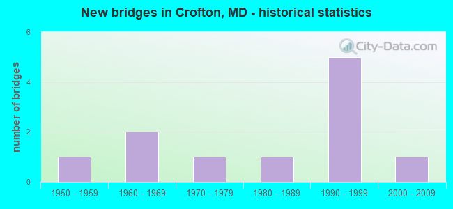
- New bridges - historical statistics
- 11950-1959
- 21960-1969
- 11970-1979
- 11980-1989
- 51990-1999
- 12000-2009

- Reconstructed bridges - Historical Statistics
- 11980-1989
- 11990-1999


- Bridge Condition - Deck
- 20.0%Very good
- 60.0%Good
- 20.0%Fair

- Bridge Condition - Superstructure
- 66.7%Good
- 33.3%Satisfactory

- Bridge Condition - Substructure
- 66.7%Good
- 33.3%Satisfactory

- Bridge Condition - Channel
- 14.3%Very good
- 42.9%Good
- 28.6%Satisfactory
- 14.3%Fair

- Bridge Condition - Culverts
- 33.3%Satisfactory
- 66.7%Fair
Find on map >> Show street view
Structure Number: 100000020028011, Location: 0.81 MI N OF MD 909 (Lat: 38.960606, Lng: -76.654417), Route carried "on" structure: State highway 424, Year Built: 1994, Status: Open, Structure Length: 10.30m (33.79ft), Average Daily Traffic: 13,992 (year 2009), Truck Traffic: 8%, Average Future Daily Traffic: 8,649 (year 2026), Design Load: HS 20+Mod, Features Intersected: IS 595
Minimum Vertical Clearance: 30+ m (98+ ft), Kilometerpoint: 5.295, Lanes on structure: 3, Lanes under structure: 8, Base Highway Network: Yes, Owner: State Highway Agency, Approaching Roadway Width: 17.1m (56.1ft), Skew: 4 degrees, Material/Design: Steel, Design/Construction: Stringer/Multi-beam, Number Of Spans In Main Unit: 2, Length of Maximum Span: 51.8m (169.9ft), Curb-To-Curb Width: 15.2m (49.9ft), Out-to-Out Width: 16.5m (54.1ft)
Condition: Deck: Good, Superstructure: Good, Substructure: Good, Inventory Rating: 54.9 metric tons, Method Used To Determine Inventory Rating: Load Factor (LF), Structural Evaluation: Better than present minimum criteria, Deck Geometry: Equal to present minimum criteria, Underclear: Better than present minimum criteria, Approach Roadway Alignment: Equal to present desirable criteria, Designated Inspection Frequency: Every 24 months, Inspection Date: May 2021, Deck Structure Type: Concrete Cast-file-Place, Wearing Surface/Protective System: Wearing Surface: Monolithic Concrete, Deck Protection: Epoxy Coated Reinforcing
Find on map >> Show street view
Structure Number: 100000020028012, Location: 0.81 MI N OF MD 909 (Lat: 38.961103, Lng: -76.655667), Route carried "on" structure: State highway 424, Year Built: 1994, Status: Open, Structure Length: 10.30m (33.79ft), Average Daily Traffic: 13,992 (year 2009), Truck Traffic: 8%, Average Future Daily Traffic: 8,649 (year 2026), Design Load: HS 20+Mod, Features Intersected: IS 595
Minimum Vertical Clearance: 30+ m (98+ ft), Kilometerpoint: 5.295, Lanes on structure: 3, Lanes under structure: 8, Base Highway Network: Yes, Owner: State Highway Agency, Approaching Roadway Width: 15.2m (49.9ft), Skew: 4 degrees, Material/Design: Steel, Design/Construction: Stringer/Multi-beam, Number Of Spans In Main Unit: 2, Length of Maximum Span: 51.8m (169.9ft), Curb-To-Curb Width: 15.2m (49.9ft), Out-to-Out Width: 16.5m (54.1ft)
Condition: Deck: Good, Superstructure: Good, Substructure: Good, Inventory Rating: 54.9 metric tons, Method Used To Determine Inventory Rating: Load Factor (LF), Structural Evaluation: Better than present minimum criteria, Deck Geometry: Equal to present minimum criteria, Underclear: Better than present minimum criteria, Approach Roadway Alignment: Equal to present desirable criteria, Designated Inspection Frequency: Every 24 months, Inspection Date: May 2021, Deck Structure Type: Concrete Cast-file-Place, Wearing Surface/Protective System: Wearing Surface: Monolithic Concrete, Deck Protection: Epoxy Coated Reinforcing
Find on map >> Show street view
Structure Number: 100000160053012, Location: ON ANNE ARUNDEL CO LINE (Lat: 38.989311, Lng: -76.705419), Route carried "on" structure: State highway 3, Year Built: 1957, Year Reconstructed: 1987, Status: Open, Structure Length: 8.14m (26.71ft), Average Daily Traffic: 75,720 (year 2009), Truck Traffic: 8%, Average Future Daily Traffic: 44,091 (year 2026), Design Load: HS 20, Features Intersected: PATUXENT RIVER
Minimum Vertical Clearance: 30+ m (98+ ft), Kilometerpoint: 3.950, Lanes on structure: 3, Base Highway Network: Yes, Owner: State Highway Agency, Approaching Roadway Width: 15.2m (49.9ft), Material/Design: Steel, Design/Construction: Stringer/Multi-beam, Number Of Spans In Main Unit: 5, Length of Maximum Span: 16.2m (53.1ft), Curb-To-Curb Width: 14.6m (47.9ft), Out-to-Out Width: 15.6m (51.2ft)
Condition: Deck: Good, Superstructure: Good, Substructure: Good, Channel: Good, Operating Rating: 74.4 metric tons, Method Used To Determine Operating Rating: Load Factor (LF), Inventory Rating: 44.4 metric tons, Method Used To Determine Inventory Rating: Load Factor (LF), Structural Evaluation: Better than present minimum criteria, Deck Geometry: Somewhat better than minimum adequacy, Waterway Adequacy: Superior to present desirable criteria, Approach Roadway Alignment: Equal to present desirable criteria, Designated Inspection Frequency: Every 24 months, Underwater Inspection Frequency: Every 48 months, Inspection Date: September 2020, Underwater Inspection Date: July 2018, Deck Structure Type: Concrete Cast-file-Place, Wearing Surface/Protective System: Wearing Surface: Monolithic Concrete, Deck Protection: Epoxy Coated Reinforcing
Find on map >> Show street view
Structure Number: 200000AA200601, Location: 60 FT S OF BELL BRANCH RD (Lat: 38.980106, Lng: -76.651750), Route carried "on" structure: County highway 6077, Year Built: 1994, Year Reconstructed: 2021, Status: Open, Structure Length: 1.31m (4.30ft), Average Daily Traffic: 193 (year 2020), Truck Traffic: 6%, Average Future Daily Traffic: 240 (year 2040), Design Load: HS 20, Features Intersected: TRIBUTARY TO BELL BRANCH, Facility Carried by Structure: WOOD BRIDGE ROAD
Minimum Vertical Clearance: 30+ m (98+ ft), Kilometerpoint: 0.000, Lanes on structure: 2, Owner: County Highway Agency, Approaching Roadway Width: 7.9m (25.9ft), Material/Design: Steel, Design/Construction: Stringer/Multi-beam, Number Of Spans In Main Unit: 1, Length of Maximum Span: 11.6m (38.1ft), Curb or Sidewalk Widths: Left: 0.0m, Right: 1.2m (3.9ft), Curb-To-Curb Width: 7.9m (25.9ft), Out-to-Out Width: 9.9m (32.5ft)
Condition: Deck: Very good, Superstructure: Satisfactory, Substructure: Satisfactory, Channel: Good, Operating Rating: 76.2 metric tons, Method Used To Determine Operating Rating: Load Factor (LF), Inventory Rating: 43.5 metric tons, Method Used To Determine Inventory Rating: Load Factor (LF), Structural Evaluation: Equal to present minimum criteria, Deck Geometry: Somewhat better than minimum adequacy, Waterway Adequacy: Equal to present desirable criteria, Approach Roadway Alignment: Equal to present desirable criteria, Length Of Structure Improvement: 1.31m (4.30ft), Designated Inspection Frequency: Every 24 months, Inspection Date: November 2021, Deck Structure Type: Wood or Timber
Find on map >> Show street view
Structure Number: 200000AA400501, Location: 0.43 MI W OF MD 3 (Lat: 39.023864, Lng: -76.701708), Route carried "on" structure: County highway 2633, Year Built: 1966, Status: Open, Structure Length: 7.19m (23.59ft), Average Daily Traffic: 9,114 (year 2016), Truck Traffic: 5%, Average Future Daily Traffic: 5,257 (year 2035), Design Load: HS 20, Features Intersected: LITTLE PATUXENT RIVER, Facility Carried by Structure: CONWAY ROAD
Minimum Vertical Clearance: 30+ m (98+ ft), Kilometerpoint: 0.692, Lanes on structure: 2, Owner: County Highway Agency, Approaching Roadway Width: 13.4m (44.0ft), Material/Design: Steel continuous, Design/Construction: Stringer/Multi-beam, Number Of Spans In Main Unit: 3, Length of Maximum Span: 27.4m (89.9ft), Curb or Sidewalk Widths: Left: 0.6m (2.0ft), Right: 0.6m (2.0ft), Curb-To-Curb Width: 9.1m (29.9ft), Out-to-Out Width: 11.0m (36.1ft)
Condition: Deck: Fair, Superstructure: Good, Substructure: Satisfactory, Channel: Satisfactory, Operating Rating: 59.9 metric tons, Method Used To Determine Operating Rating: Load Factor (LF), Inventory Rating: 35.8 metric tons, Method Used To Determine Inventory Rating: Load Factor (LF), Structural Evaluation: Equal to present minimum criteria, Deck Geometry: Meets minimum limits, Waterway Adequacy: Equal to present minimum criteria, Approach Roadway Alignment: Equal to present desirable criteria, Length Of Structure Improvement: 7.19m (23.59ft), Designated Inspection Frequency: Every 24 months, Inspection Date: January 2020, Bridge Improvement Cost: $48,000, Total Project Cost: $48,000, Deck Structure Type: Concrete Cast-file-Place, Wearing Surface/Protective System: Wearing Surface: Bituminous, Membrane: Preformed Fabric
Find on map >> Show street view
Structure Number: 200000AA402303, Location: 0.4 MI EAST OF ROUTE 424 (Lat: 39.010839, Lng: -76.674697), Route carried "on" structure: County highway , Year Built: 1980, Status: Open, Structure Length: 0.86m (2.82ft), Average Daily Traffic: 1,361 (year 2018), Average Future Daily Traffic: 1,700 (year 2040), Design Load: HS 20, Features Intersected: TRIBUTARY TO LITTLE PATU, Facility Carried by Structure: KINGSGATE DRIVE
Minimum Vertical Clearance: 30+ m (98+ ft), Kilometerpoint: 0.552, Lanes on structure: 2, Owner: County Highway Agency, Approaching Roadway Width: 12.2m (40.0ft), Skew: 5 degrees, Material/Design: Steel, Design/Construction: Culvert, Length of Maximum Span: 1.8m (5.9ft), Curb or Sidewalk Widths: Left: 0.3m (1.0ft), Right: 0.3m (1.0ft)
Condition: Channel: Very good, Culverts: Satisfactory, Structural Evaluation: Equal to present minimum criteria, Waterway Adequacy: Equal to present desirable criteria, Approach Roadway Alignment: Equal to present desirable criteria, Designated Inspection Frequency: Every 24 months, Inspection Date: July 2021
Find on map >> Show street view
Structure Number: 200000AA402403, Location: 0.5 MI. SE OF MD 3 (Lat: 39.034025, Lng: -76.671078), Route carried "on" structure: County highway , Year Built: 2004, Status: Open, Structure Length: 1.01m (3.31ft), Average Daily Traffic: 11,666 (year 2018), Average Future Daily Traffic: 18,500 (year 2040), Design Load: HS 20, Features Intersected: TOWSERS BRANCH, Facility Carried by Structure: REIDEL ROAD
Minimum Vertical Clearance: 30+ m (98+ ft), Kilometerpoint: 3.168, Lanes on structure: 2, Owner: County Highway Agency, Approaching Roadway Width: 14.6m (47.9ft), Material/Design: Aluminum, Iron, Design/Construction: Arch - Deck, Length of Maximum Span: 2.7m (8.9ft), Curb or Sidewalk Widths: Left: 0.2m (0.7ft), Right: 0.2m (0.7ft), Curb-To-Curb Width: 14.6m (47.9ft), Out-to-Out Width: 14.9m (48.9ft)
Condition: Superstructure: Satisfactory, Substructure: Good, Channel: Good, Structural Evaluation: Equal to present minimum criteria, Deck Geometry: Superior to present desirable criteria, Waterway Adequacy: Equal to present minimum criteria, Approach Roadway Alignment: Equal to present minimum criteria, Designated Inspection Frequency: Every 24 months, Inspection Date: August 2021
Find on map >> Show street view
Structure Number: 200000AA402603, Location: 1.2 MI EAST OF RTE 424 (Lat: 38.978025, Lng: -76.647114), Route carried "on" structure: County highway , Year Built: 1970, Year Reconstructed: 1990, Status: Open, Structure Length: 1.16m (3.81ft), Average Daily Traffic: 656 (year 2018), Truck Traffic: 2%, Average Future Daily Traffic: 700 (year 2040), Design Load: HS 20, Features Intersected: BELL BRANCH, Facility Carried by Structure: BELL BRANCH ROAD
Minimum Vertical Clearance: 30+ m (98+ ft), Kilometerpoint: 2.393, Lanes on structure: 2, Owner: County Highway Agency, Approaching Roadway Width: 6.1m (20.0ft), Material/Design: Steel, Design/Construction: Culvert, Length of Maximum Span: 6.1m (20.0ft)
Condition: Channel: Satisfactory, Culverts: Fair, Operating Rating: 65.3 metric tons, Method Used To Determine Operating Rating: Load Factor (LF), Inventory Rating: 39.0 metric tons, Method Used To Determine Inventory Rating: Load Factor (LF), Structural Evaluation: Somewhat better than minimum adequacy, Waterway Adequacy: Superior to present desirable criteria, Approach Roadway Alignment: Equal to present minimum criteria, Designated Inspection Frequency: Every 24 months, Inspection Date: July 2021
Find on map >> Show street view
Structure Number: 200000AA501803, Location: 1 MI EAST OF ROUTE 3 N (Lat: 39.005503, Lng: -76.682058), Route carried "on" structure: County highway , Year Built: 1968, Status: Open, Structure Length: 0.79m (2.59ft), Average Daily Traffic: 1,705 (year 2021), Average Future Daily Traffic: 1,803 (year 2041), Design Load: HS 20, Features Intersected: TRIBUTARY TO LITTLE PATU, Facility Carried by Structure: CROFTON PARKWAY
Minimum Vertical Clearance: 30+ m (98+ ft), Kilometerpoint: 5.329, Lanes on structure: 2, Owner: County Highway Agency, Approaching Roadway Width: 13.4m (44.0ft), Material/Design: Steel, Design/Construction: Culvert, Length of Maximum Span: 3.4m (11.2ft), Curb or Sidewalk Widths: Left: 1.8m (5.9ft), Right: 1.8m (5.9ft)
Condition: Channel: Fair, Culverts: Fair, Structural Evaluation: Somewhat better than minimum adequacy, Waterway Adequacy: Better than present minimum criteria, Approach Roadway Alignment: Equal to present desirable criteria, Designated Inspection Frequency: Every 24 months, Inspection Date: July 2021
Find on map >> Show street view
Structure Number: 100000020028011, Location: 1.04 MI N OF MD 909 (Lat: 38.960606, Lng: -76.654417), Route carried "under" structure: Interstate 595, Year Built: 1994, Structure Length: 0. m, Average Daily Traffic: 101,670 (year 2009), Features Intersected: IS 595, Facility Carried by Structure: MD 424
Minimum Vertical Clearance: 5.18m (16.99ft), Kilometerpoint: 3.492, Lanes on structure: 2, Lanes under structure: 4, Material/Design: Steel, Design/Construction: Stringer/Multi-beam, Length of Maximum Span: 25.9m (85.0ft)
Find on map >> Show street view
Structure Number: 100000020028012, Location: 2.15 MILES EAST OF PG CO (Lat: 38.961103, Lng: -76.655667), Route carried "under" structure: Interstate 595, Year Built: 1994, Structure Length: 0. m, Average Daily Traffic: 101,670 (year 2009), Truck Traffic: 8%, Features Intersected: IS 595, Facility Carried by Structure: MD 424
Minimum Vertical Clearance: 5.18m (16.99ft), Kilometerpoint: 3.459, Lanes on structure: 3, Lanes under structure: 8, Material/Design: Steel, Design/Construction: Stringer/Multi-beam, Length of Maximum Span: 51.8m (169.9ft)