Bridge Statistics for Cranford, New Jersey (NJ)
Condition, Traffic, Stress, Structural Evaluation, Project Costs
- National Bridge Inventory (NBI) Statistics
- 17Number of bridges
- 207ft / 62.8mTotal length
- $436,000Total costs
- 1,168,810Total average daily traffic
- 15,806Total average daily truck traffic
- National Bridge Inventory (NBI) Registered Bridges for Cranford
- No street view available for this location
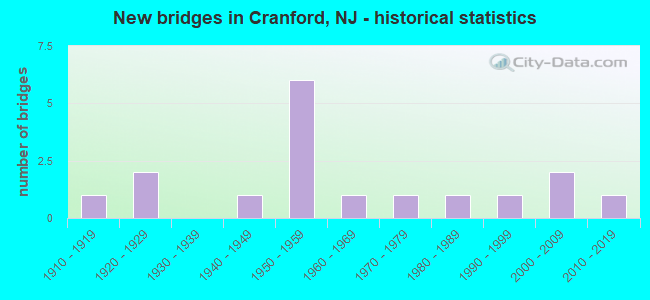
- New bridges - historical statistics
- 11910-1919
- 21920-1929
- 11940-1949
- 61950-1959
- 11960-1969
- 11970-1979
- 11980-1989
- 11990-1999
- 22000-2009
- 12010-2019

- Reconstructed bridges - Historical Statistics
- 41970-1979
- 21980-1989


- Bridge Condition - Deck
- 33.3%Good
- 58.3%Satisfactory
- 8.3%Fair

- Bridge Condition - Superstructure
- 38.5%Very good
- 7.7%Good
- 38.5%Satisfactory
- 15.4%Fair

- Bridge Condition - Substructure
- 7.7%Very good
- 61.5%Good
- 7.7%Satisfactory
- 23.1%Fair

- Bridge Condition - Channel
- 70.0%Satisfactory
- 30.0%Fair
Find on map >> Show street view
Structure Number: 2003006, Location: NEAR RIVERSIDE DRIVE (Lat: 40.673169, Lng: -74.313000), Route carried "on" structure: County highway 509, Year Built: 1925, Year Reconstructed: 1992, Status: Open, Structure Length: 2.19m (7.19ft), Average Daily Traffic: 9,344 (year 2020), Truck Traffic: 4%, Average Future Daily Traffic: 11,402 (year 2040), Design Load: HS 20+Mod, Features Intersected: RAHWAY RIVER
Minimum Vertical Clearance: 30+ m (98+ ft), Kilometerpoint: 15.884, Lanes on structure: 4, Owner: County Highway Agency, Approaching Roadway Width: 14.0m (45.9ft), Material/Design: Prestressed concrete, Design/Construction: Box Beam or Girders - Single/Spread, Number Of Spans In Main Unit: 2, Length of Maximum Span: 9.8m (32.2ft), Curb or Sidewalk Widths: Left: 1.8m (5.9ft), Right: 1.8m (5.9ft), Curb-To-Curb Width: 14.0m (45.9ft), Out-to-Out Width: 18.5m (60.7ft)
Condition: Deck: Satisfactory, Superstructure: Very good, Substructure: Fair, Channel: Fair, Operating Rating: 75.3 metric tons, Method Used To Determine Operating Rating: Load Factor (LF), Inventory Rating: 45.4 metric tons, Method Used To Determine Inventory Rating: Load Factor (LF), Structural Evaluation: Somewhat better than minimum adequacy, Deck Geometry: High priority of replacement, Waterway Adequacy: Equal to present minimum criteria, Approach Roadway Alignment: Better than present minimum criteria, Length Of Structure Improvement: 2.19m (7.19ft), Designated Inspection Frequency: Every 24 months, Underwater Inspection Frequency: Every 48 months, Inspection Date: Febuary 2020, Underwater Inspection Date: June 2018, Bridge Improvement Cost: $107,000, Roadway Improvement Cost: $18,000, Total Project Cost: $176,000 ( Estimate for 2020), Deck Structure Type: Concrete Cast-file-Place, Wearing Surface/Protective System: Wearing Surface: Other, Deck Protection: Epoxy Coated Reinforcing
Find on map >> Show street view
Structure Number: 2003008, Location: NEAR HAMPTON STREET (Lat: 40.658439, Lng: -74.310131), Route carried "on" structure: City street , Year Built: 2006, Status: Open, Structure Length: 2.62m (8.60ft), Average Daily Traffic: 2,087 (year 2020), Truck Traffic: 1%, Average Future Daily Traffic: 2,547 (year 2040), Design Load: HS 20+Mod, Features Intersected: RAHWAY RIVER, Facility Carried by Structure: EASTMAN STREET
Minimum Vertical Clearance: 30+ m (98+ ft), Kilometerpoint: 0.000, Lanes on structure: 2, Owner: County Highway Agency, Approaching Roadway Width: 9.8m (32.2ft), Skew: 2 degrees, Material/Design: Prestressed concrete, Design/Construction: Box Beam or Girders - Multiple, Number Of Spans In Main Unit: 1, Length of Maximum Span: 24.4m (80.1ft), Curb or Sidewalk Widths: Left: 2.0m (6.6ft), Right: 2.0m (6.6ft), Curb-To-Curb Width: 9.8m (32.2ft), Out-to-Out Width: 14.7m (48.2ft)
Condition: Deck: Satisfactory, Superstructure: Good, Substructure: Good, Channel: Satisfactory, Inventory Rating: 67.1 metric tons, Method Used To Determine Inventory Rating: Load Factor (LF), Structural Evaluation: Better than present minimum criteria, Deck Geometry: Meets minimum limits, Waterway Adequacy: Better than present minimum criteria, Approach Roadway Alignment: Equal to present minimum criteria, Designated Inspection Frequency: Every 24 months, Inspection Date: March 2020, Deck Structure Type: Concrete Cast-file-Place, Wearing Surface/Protective System: Wearing Surface: Other, Deck Protection: Galvanized Reinforcing
Find on map >> Show street view
Structure Number: 2003014, Location: NEAR ORANGE AVENUE (Lat: 40.659961, Lng: -74.305861), Route carried "on" structure: County highway 615, Year Built: 2010, Status: Open, Structure Length: 2.87m (9.42ft), Average Daily Traffic: 16,969 (year 2020), Truck Traffic: 4%, Average Future Daily Traffic: 20,706 (year 2040), Design Load: HL 93, Features Intersected: RAHWAY RIVER, Facility Carried by Structure: SPRINGFIELD AVENUE
Minimum Vertical Clearance: 30+ m (98+ ft), Kilometerpoint: 7.017, Lanes on structure: 2, Owner: County Highway Agency, Approaching Roadway Width: 9.8m (32.2ft), Skew: 1 degrees, Material/Design: Steel, Design/Construction: Stringer/Multi-beam, Number Of Spans In Main Unit: 1, Length of Maximum Span: 26.8m (87.9ft), Curb or Sidewalk Widths: Left: 2.1m (6.9ft), Right: 2.1m (6.9ft), Curb-To-Curb Width: 9.8m (32.2ft), Out-to-Out Width: 14.9m (48.9ft)
Condition: Deck: Good, Superstructure: Very good, Substructure: Very good, Channel: Satisfactory, Operating Rating: 52.8 metric tons, Method Used To Determine Operating Rating: Load and Resistance Factor Rating (LRFR) rating reported by rating factor(RF) method using HL-93 loadings, Inventory Rating: 40.8 metric tons, Method Used To Determine Inventory Rating: Load and Resistance Factor Rating (LRFR) rating reported by rating factor(RF) method using HL-93 loadings, Structural Evaluation: Equal to present desirable criteria, Deck Geometry: Meets minimum limits, Waterway Adequacy: Better than present minimum criteria, Approach Roadway Alignment: Equal to present desirable criteria, Designated Inspection Frequency: Every 24 months, Inspection Date: March 2020, Deck Structure Type: Concrete Cast-file-Place, Wearing Surface/Protective System: Wearing Surface: Monolithic Concrete, Deck Protection: Galvanized Reinforcing
Find on map >> Show street view
Structure Number: 2003016, Location: NO UNION AVE AT RAHWAY RV (Lat: 40.658469, Lng: -74.301669), Route carried "on" structure: City street , Year Built: 1915, Status: Open, Structure Length: 2.62m (8.60ft), Average Daily Traffic: 2,474 (year 2020), Truck Traffic: 1%, Average Future Daily Traffic: 3,019 (year 2040), Features Intersected: RAHWAY RIVER, Facility Carried by Structure: NORTH UNION AVENUE
Minimum Vertical Clearance: 30+ m (98+ ft), Kilometerpoint: 0.000, Lanes on structure: 2, Owner: County Highway Agency, Approaching Roadway Width: 9.2m (30.2ft), Material/Design: Concrete, Design/Construction: Arch - Deck, Number Of Spans In Main Unit: 1, Length of Maximum Span: 24.4m (80.1ft), Curb or Sidewalk Widths: Left: 2.5m (8.2ft), Right: 2.5m (8.2ft), Curb-To-Curb Width: 9.2m (30.2ft), Out-to-Out Width: 15.2m (49.9ft)
Condition: Superstructure: Fair, Substructure: Fair, Channel: Fair, Inventory Rating: 28.1 metric tons, Method Used To Determine Inventory Rating: Load Factor (LF), Structural Evaluation: Somewhat better than minimum adequacy, Deck Geometry: Meets minimum limits, Waterway Adequacy: Equal to present desirable criteria, Approach Roadway Alignment: Better than present minimum criteria, Designated Inspection Frequency: Every 24 months, Inspection Date: Febuary 2020
Find on map >> Show street view
Structure Number: 2003018, Location: NEAR COUNTY PARK DRIVE (Lat: 40.672861, Lng: -74.314561), Route carried "on" structure: County highway 509, Year Built: 1925, Year Reconstructed: 1992, Status: Open, Structure Length: 0.94m (3.08ft), Average Daily Traffic: 9,344 (year 2020), Truck Traffic: 4%, Average Future Daily Traffic: 11,402 (year 2040), Design Load: HS 20+Mod, Features Intersected: NOMAHEGAN BROOK, Facility Carried by Structure: KENILWORTH BLVD
Minimum Vertical Clearance: 30+ m (98+ ft), Kilometerpoint: 15.739, Lanes on structure: 4, Owner: County Highway Agency, Approaching Roadway Width: 14.0m (45.9ft), Material/Design: Prestressed concrete, Design/Construction: Box Beam or Girders - Single/Spread, Number Of Spans In Main Unit: 1, Length of Maximum Span: 8.2m (26.9ft), Curb or Sidewalk Widths: Left: 1.8m (5.9ft), Right: 1.5m (4.9ft), Curb-To-Curb Width: 14.0m (45.9ft), Out-to-Out Width: 18.5m (60.7ft)
Condition: Deck: Satisfactory, Superstructure: Very good, Substructure: Satisfactory, Channel: Satisfactory, Operating Rating: 77.1 metric tons, Method Used To Determine Operating Rating: Load Factor (LF), Inventory Rating: 46.3 metric tons, Method Used To Determine Inventory Rating: Load Factor (LF), Structural Evaluation: Equal to present minimum criteria, Deck Geometry: High priority of replacement, Waterway Adequacy: Better than present minimum criteria, Approach Roadway Alignment: Equal to present desirable criteria, Length Of Structure Improvement: 0.94m (3.08ft), Designated Inspection Frequency: Every 24 months, Inspection Date: Febuary 2020, Bridge Improvement Cost: $46,000, Roadway Improvement Cost: $8,000, Total Project Cost: $76,000 ( Estimate for 2020), Deck Structure Type: Concrete Cast-file-Place, Wearing Surface/Protective System: Wearing Surface: Other, Deck Protection: Epoxy Coated Reinforcing
Find on map >> Show street view
Structure Number: 2003028, Location: NEAR CENTENNIAL AVENUE (Lat: 40.654950, Lng: -74.300950), Route carried "on" structure: County highway 610, Year Built: 1983, Status: Open, Structure Length: 2.35m (7.71ft), Average Daily Traffic: 14,146 (year 2020), Truck Traffic: 4%, Average Future Daily Traffic: 17,261 (year 2040), Design Load: HS 20, Features Intersected: RAHWAY RIVER
Minimum Vertical Clearance: 30+ m (98+ ft), Kilometerpoint: 8.948, Lanes on structure: 4, Owner: County Highway Agency, Approaching Roadway Width: 14.0m (45.9ft), Skew: 1 degrees, Material/Design: Prestressed concrete, Design/Construction: Box Beam or Girders - Multiple, Number Of Spans In Main Unit: 1, Length of Maximum Span: 22.9m (75.1ft), Curb or Sidewalk Widths: Left: 1.6m (5.2ft), Right: 2.4m (7.9ft), Curb-To-Curb Width: 14.0m (45.9ft), Out-to-Out Width: 18.8m (61.7ft)
Condition: Deck: Good, Superstructure: Satisfactory, Substructure: Good, Channel: Satisfactory, Operating Rating: 46.3 metric tons, Method Used To Determine Operating Rating: Load Factor (LF), Inventory Rating: 28.1 metric tons, Method Used To Determine Inventory Rating: Load Factor (LF), Structural Evaluation: Equal to present minimum criteria, Deck Geometry: High priority of replacement, Waterway Adequacy: Equal to present minimum criteria, Approach Roadway Alignment: Equal to present desirable criteria, Length Of Structure Improvement: 2.35m (7.71ft), Designated Inspection Frequency: Every 24 months, Inspection Date: Febuary 2020, Bridge Improvement Cost: $114,000, Roadway Improvement Cost: $17,000, Total Project Cost: $184,000 ( Estimate for 2020), Deck Structure Type: Concrete Cast-file-Place, Wearing Surface/Protective System: Wearing Surface: Other, Deck Protection: Epoxy Coated Reinforcing
Find on map >> Show street view
Structure Number: 2003045, Location: LINCOLN AVE AT RAHWAY RIV (Lat: 40.650169, Lng: -74.301611), Route carried "on" structure: City street , Year Built: 1997, Status: Open, Structure Length: 2.32m (7.61ft), Average Daily Traffic: 9,627 (year 2020), Truck Traffic: 3%, Average Future Daily Traffic: 11,747 (year 2040), Design Load: HS 25 or greater, Features Intersected: RAHWAY RIVER, Facility Carried by Structure: LINCOLN AVENUE
Minimum Vertical Clearance: 30+ m (98+ ft), Kilometerpoint: 0.950, Lanes on structure: 2, Owner: County Highway Agency, Approaching Roadway Width: 11.0m (36.1ft), Material/Design: Prestressed concrete, Design/Construction: Box Beam or Girders - Multiple, Number Of Spans In Main Unit: 1, Length of Maximum Span: 21.9m (71.9ft), Curb or Sidewalk Widths: Left: 1.8m (5.9ft), Right: 1.8m (5.9ft), Curb-To-Curb Width: 11.0m (36.1ft), Out-to-Out Width: 16.5m (54.1ft)
Condition: Deck: Satisfactory, Superstructure: Very good, Substructure: Good, Channel: Satisfactory, Operating Rating: 74.4 metric tons, Method Used To Determine Operating Rating: Load Factor (LF), Inventory Rating: 44.5 metric tons, Method Used To Determine Inventory Rating: Load Factor (LF), Structural Evaluation: Better than present minimum criteria, Deck Geometry: Meets minimum limits, Waterway Adequacy: Better than present minimum criteria, Approach Roadway Alignment: Equal to present minimum criteria, Designated Inspection Frequency: Every 24 months, Inspection Date: Febuary 2020, Deck Structure Type: Concrete Cast-file-Place, Wearing Surface/Protective System: Wearing Surface: Monolithic Concrete, Deck Protection: Epoxy Coated Reinforcing
Find on map >> Show street view
Structure Number: 2003071, Location: NEAR HOLLY STREET (Lat: 40.657111, Lng: -74.310969), Route carried "on" structure: City street , Year Built: 1979, Status: Open, Structure Length: 0.61m (2.00ft), Average Daily Traffic: 7,141 (year 2020), Truck Traffic: 1%, Average Future Daily Traffic: 8,714 (year 2040), Design Load: HS 20+Mod, Features Intersected: STREAM 10-25, Facility Carried by Structure: ORCHARD STREET
Minimum Vertical Clearance: 30+ m (98+ ft), Kilometerpoint: 0.000, Lanes on structure: 2, Owner: County Highway Agency, Approaching Roadway Width: 10.4m (34.1ft), Material/Design: Concrete, Design/Construction: Culvert, Number Of Spans In Main Unit: 1, Length of Maximum Span: 6.1m (20.0ft), Curb or Sidewalk Widths: Left: 2.9m (9.5ft), Right: 2.9m (9.5ft), Curb-To-Curb Width: 10.4m (34.1ft), Out-to-Out Width: 17.1m (56.1ft)
Condition: Channel: Satisfactory, Culverts: Good, Operating Rating: 44.5 metric tons, Method Used To Determine Operating Rating: Load Factor (LF), Inventory Rating: 26.3 metric tons, Method Used To Determine Inventory Rating: Load Factor (LF), Structural Evaluation: Equal to present minimum criteria, Deck Geometry: Meets minimum limits, Waterway Adequacy: Equal to present desirable criteria, Approach Roadway Alignment: Better than present minimum criteria, Designated Inspection Frequency: Every 24 months, Inspection Date: March 2020, Deck Structure Type: Concrete Cast-file-Place, Wearing Surface/Protective System: Wearing Surface: Bituminous
Find on map >> Show street view
Structure Number: 2003072, Location: NEAR HAMPTON STREET (Lat: 40.661400, Lng: -74.308239), Route carried "on" structure: County highway 615, Year Built: 2003, Status: Open, Structure Length: 2.41m (7.91ft), Average Daily Traffic: 16,969 (year 2020), Truck Traffic: 4%, Average Future Daily Traffic: 20,706 (year 2040), Design Load: HS 25 or greater, Features Intersected: RAHWAY RIVER
Minimum Vertical Clearance: 30+ m (98+ ft), Kilometerpoint: 7.258, Lanes on structure: 2, Owner: County Highway Agency, Approaching Roadway Width: 11.0m (36.1ft), Material/Design: Prestressed concrete, Design/Construction: Box Beam or Girders - Multiple, Number Of Spans In Main Unit: 1, Length of Maximum Span: 22.6m (74.1ft), Curb or Sidewalk Widths: Left: 1.9m (6.2ft), Right: 1.9m (6.2ft), Curb-To-Curb Width: 11.0m (36.1ft), Out-to-Out Width: 16.0m (52.5ft)
Condition: Deck: Good, Superstructure: Very good, Substructure: Good, Channel: Satisfactory, Inventory Rating: 71.7 metric tons, Method Used To Determine Inventory Rating: Load Factor (LF), Structural Evaluation: Better than present minimum criteria, Deck Geometry: Meets minimum limits, Waterway Adequacy: Better than present minimum criteria, Approach Roadway Alignment: Equal to present desirable criteria, Designated Inspection Frequency: Every 24 months, Inspection Date: March 2020, Deck Structure Type: Concrete Cast-file-Place, Wearing Surface/Protective System: Wearing Surface: Monolithic Concrete, Deck Protection: Galvanized Reinforcing
Find on map >> Show street view
Structure Number: 2008156, Location: 0.7 MILES WEST OF GSP (Lat: 40.656389, Lng: -74.300831), Route carried "on" structure: State highway 28, Year Built: 1965, Status: Open, Structure Length: 1.92m (6.30ft), Average Daily Traffic: 20,435 (year 2021), Truck Traffic: 4%, Average Future Daily Traffic: 24,385 (year 2041), Design Load: HS 20+Mod, Features Intersected: RAHWAY RIVER
Minimum Vertical Clearance: 30+ m (98+ ft), Kilometerpoint: 35.985, Lanes on structure: 4, Base Highway Network: Yes, Owner: State Highway Agency, Approaching Roadway Width: 15.2m (49.9ft), Skew: 1 degrees, Material/Design: Steel, Design/Construction: Stringer/Multi-beam, Number Of Spans In Main Unit: 1, Length of Maximum Span: 18.0m (59.1ft), Curb or Sidewalk Widths: Left: 2.1m (6.9ft), Right: 2.1m (6.9ft), Curb-To-Curb Width: 15.2m (49.9ft), Out-to-Out Width: 20.3m (66.6ft)
Condition: Deck: Satisfactory, Superstructure: Satisfactory, Substructure: Good, Channel: Fair, Operating Rating: 67.1 metric tons, Method Used To Determine Operating Rating: Load Factor (LF), Inventory Rating: 38.1 metric tons, Method Used To Determine Inventory Rating: Load Factor (LF), Structural Evaluation: Equal to present minimum criteria, Deck Geometry: High priority of corrective action, Waterway Adequacy: Equal to present desirable criteria, Approach Roadway Alignment: Equal to present desirable criteria, Designated Inspection Frequency: Every 24 months, Inspection Date: July 2021, Deck Structure Type: Concrete Cast-file-Place, Wearing Surface/Protective System: Wearing Surface: Bituminous
Find on map >> Show street view
Structure Number: 361382T, Location: 6.2 MI NORTH OF RT 27 (Lat: 40.651725, Lng: -74.287511), Route carried "on" structure: Other road GSP, Year Built: 1951, Year Reconstructed: 1976, Status: Open, Structure Length: 1.74m (5.71ft), Average Daily Traffic: 248,904 (year 2021), Truck Traffic: 1%, Average Future Daily Traffic: 303,710 (year 2041), Design Load: HS 20, Features Intersected: MYRTLE STREET
Minimum Vertical Clearance: 30+ m (98+ ft), Kilometerpoint: 222.540, Lanes on structure: 10, Lanes under structure: 2, Base Highway Network: Yes, Toll: On toll road, Owner: State Toll Authority, Approaching Roadway Width: 39.9m (130.9ft), Skew: 30 degrees, Material/Design: Steel, Design/Construction: Stringer/Multi-beam, Number Of Spans In Main Unit: 1, Length of Maximum Span: 16.5m (54.1ft), Curb-To-Curb Width: 39.3m (128.9ft), Out-to-Out Width: 41.1m (134.8ft)
Condition: Deck: Good, Superstructure: Satisfactory, Substructure: Good, Operating Rating: 58.3 metric tons, Method Used To Determine Operating Rating: Load and Resistance Factor Rating (LRFR) rating reported by rating factor(RF) method using HL-93 loadings, Inventory Rating: 44.7 metric tons, Method Used To Determine Inventory Rating: Load and Resistance Factor Rating (LRFR) rating reported by rating factor(RF) method using HL-93 loadings, Structural Evaluation: Equal to present minimum criteria, Deck Geometry: Meets minimum limits, Underclear: Meets minimum limits, Approach Roadway Alignment: Equal to present desirable criteria, Designated Inspection Frequency: Every 24 months, Inspection Date: July 2021, Deck Structure Type: Concrete Cast-file-Place, Wearing Surface/Protective System: Wearing Surface: Bituminous, Membrane: Preformed Fabric
Find on map >> Show street view
Structure Number: 361383T, Location: 6.4 MILES NORTH OF RT 27 (Lat: 40.653981, Lng: -74.297261), Route carried "on" structure: Other road GSP, Year Built: 1948, Year Reconstructed: 1976, Status: Open, Structure Length: 9.72m (31.89ft), Average Daily Traffic: 267,368 (year 2021), Truck Traffic: 1%, Average Future Daily Traffic: 326,240 (year 2041), Design Load: HS 20, Features Intersected: LEHIGH VALLEY MAIN LINE, Facility Carried by Structure: PARKWAY N/S
Minimum Vertical Clearance: 30+ m (98+ ft), Kilometerpoint: 222.765, Lanes on structure: 10, Base Highway Network: Yes, Toll: On toll road, Owner: State Toll Authority, Approaching Roadway Width: 39.9m (130.9ft), Skew: 34 degrees, Material/Design: Steel continuous, Design/Construction: Stringer/Multi-beam, Number Of Spans In Main Unit: 5, Length of Maximum Span: 22.9m (75.1ft), Curb-To-Curb Width: 39.6m (129.9ft), Out-to-Out Width: 41.5m (136.2ft)
Condition: Deck: Satisfactory, Superstructure: Satisfactory, Substructure: Good, Operating Rating: 73.2 metric tons, Method Used To Determine Operating Rating: Load and Resistance Factor Rating (LRFR) rating reported by rating factor(RF) method using HL-93 loadings, Inventory Rating: 56.4 metric tons, Method Used To Determine Inventory Rating: Load and Resistance Factor Rating (LRFR) rating reported by rating factor(RF) method using HL-93 loadings, Structural Evaluation: Equal to present minimum criteria, Deck Geometry: Meets minimum limits, Underclear: Somewhat better than minimum adequacy, Approach Roadway Alignment: Equal to present desirable criteria, Designated Inspection Frequency: Every 24 months, Inspection Date: July 2021, Deck Structure Type: Concrete Cast-file-Place, Wearing Surface/Protective System: Wearing Surface: Bituminous, Membrane: Preformed Fabric
Find on map >> Show street view
Structure Number: 361384T, Location: 6.5 MILE NORTH OF RT 27 (Lat: 40.655172, Lng: -74.287489), Route carried "on" structure: Other road GSP, Year Built: 1952, Year Reconstructed: 1976, Status: Open, Structure Length: 7.10m (23.29ft), Average Daily Traffic: 244,149 (year 2021), Truck Traffic: 1%, Average Future Daily Traffic: 297,909 (year 2041), Design Load: H 20, Features Intersected: SIRT RAILROAD
Minimum Vertical Clearance: 30+ m (98+ ft), Kilometerpoint: 222.733, Lanes on structure: 10, Base Highway Network: Yes, Toll: On toll road, Owner: State Toll Authority, Approaching Roadway Width: 39.3m (128.9ft), Skew: 32 degrees, Material/Design: Steel continuous, Design/Construction: Stringer/Multi-beam, Number Of Spans In Main Unit: 3, Length of Maximum Span: 23.5m (77.1ft), Curb-To-Curb Width: 39.3m (128.9ft), Out-to-Out Width: 41.1m (134.8ft)
Condition: Deck: Satisfactory, Superstructure: Satisfactory, Substructure: Good, Operating Rating: 58.6 metric tons, Method Used To Determine Operating Rating: Load and Resistance Factor Rating (LRFR) rating reported by rating factor(RF) method using HL-93 loadings, Inventory Rating: 45.0 metric tons, Method Used To Determine Inventory Rating: Load and Resistance Factor Rating (LRFR) rating reported by rating factor(RF) method using HL-93 loadings, Structural Evaluation: Equal to present minimum criteria, Deck Geometry: Meets minimum limits, Underclear: Superior to present desirable criteria, Approach Roadway Alignment: Equal to present desirable criteria, Designated Inspection Frequency: Every 24 months, Inspection Date: July 2021, Deck Structure Type: Concrete Cast-file-Place, Wearing Surface/Protective System: Wearing Surface: Bituminous, Membrane: Other
Find on map >> Show street view
Structure Number: 361386T, Location: 6.7 MI NORTH OF RT 27 (Lat: 40.657656, Lng: -74.287228), Route carried "on" structure: Other road GSP, Year Built: 1951, Year Reconstructed: 1976, Status: Open, Structure Length: 23.41m (76.80ft), Average Daily Traffic: 248,904 (year 2021), Truck Traffic: 1%, Average Future Daily Traffic: 303,710 (year 2041), Design Load: HS 20, Features Intersected: NJ 28&SOUTH AVE& RRS
Minimum Vertical Clearance: 30+ m (98+ ft), Kilometerpoint: 223.184, Lanes on structure: 10, Lanes under structure: 8, Base Highway Network: Yes, Toll: On toll road, Owner: State Toll Authority, Approaching Roadway Width: 42.1m (138.1ft), Skew: 31 degrees, Material/Design: Steel continuous, Design/Construction: Stringer/Multi-beam, Number Of Spans In Main Unit: 8, Number Of Approach Spans: 3, Length of Maximum Span: 66.1m (216.9ft), Curb-To-Curb Width: 42.2m (138.5ft), Out-to-Out Width: 44.2m (145.0ft)
Condition: Deck: Fair, Superstructure: Fair, Substructure: Fair, Operating Rating: 33.6 metric tons, Method Used To Determine Operating Rating: Load Factor (LF), Inventory Rating: 19.9 metric tons, Method Used To Determine Inventory Rating: Load Factor (LF), Structural Evaluation: Somewhat better than minimum adequacy, Deck Geometry: Equal to present minimum criteria, Underclear: Meets minimum limits, Approach Roadway Alignment: Equal to present desirable criteria, Designated Inspection Frequency: Every 24 months, Inspection Date: July 2021, Deck Structure Type: Concrete Cast-file-Place, Wearing Surface/Protective System: Wearing Surface: Bituminous, Membrane: Preformed Fabric
Find on map >> Show street view
Structure Number: 361382T, Location: 6.2 MI NORTH OF RT 27 (Lat: 40.651725, Lng: -74.287511), Route carried "under" structure: City street , Year Built: 1951, Structure Length: 0. m, Average Daily Traffic: 6,965 (year 2021), Truck Traffic: 1%, Features Intersected: MYRTLE STREET, Facility Carried by Structure: GSP
Minimum Vertical Clearance: 4.36m (14.30ft), Kilometerpoint: 0.000, Lanes on structure: 10, Lanes under structure: 2, Material/Design: Steel, Design/Construction: Stringer/Multi-beam, Length of Maximum Span: 16.5m (54.1ft)
Find on map >> Show street view
Structure Number: 361386T, Location: 6.7 MI NORTH OF RT 27 (Lat: 40.657656, Lng: -74.287228), Route carried "under" structure: State highway 28, Year Built: 1951, Structure Length: 0. m, Average Daily Traffic: 32,071 (year 2021), Truck Traffic: 4%, Features Intersected: NJ 28&SOUTH AVE& RRS, Facility Carried by Structure: GSP
Minimum Vertical Clearance: 8.33m (27.33ft), Kilometerpoint: 37.160, Lanes on structure: 10, Lanes under structure: 6, Material/Design: Steel continuous, Design/Construction: Stringer/Multi-beam, Length of Maximum Span: 66.1m (216.9ft)
Find on map >> Show street view
Structure Number: 361386T, Location: 6.7 MI NORTH OF RT 27 (Lat: 40.657656, Lng: -74.287228), Route carried "under" structure: County highway 610, Year Built: 1951, Structure Length: 0. m, Average Daily Traffic: 11,913 (year 2021), Truck Traffic: 4%, Features Intersected: NJ 28&SOUTH AVE& RRS, Facility Carried by Structure: GSP
Minimum Vertical Clearance: 7.77m (25.49ft), Kilometerpoint: 10.139, Lanes on structure: 10, Lanes under structure: 2, Material/Design: Steel continuous, Design/Construction: Stringer/Multi-beam, Length of Maximum Span: 66.1m (216.9ft)