Bridge Statistics for Craig, Colorado (CO)
Condition, Traffic, Stress, Structural Evaluation, Project Costs
- National Bridge Inventory (NBI) Statistics
- 22Number of bridges
- 194ft / 58.7mTotal length
- $1,110,000Total costs
- 39,095Total average daily traffic
- 7,486Total average daily truck traffic
- 45,131Total future (year 2040) average daily traffic
- National Bridge Inventory (NBI) Registered Bridges for Craig
- No street view available for this location
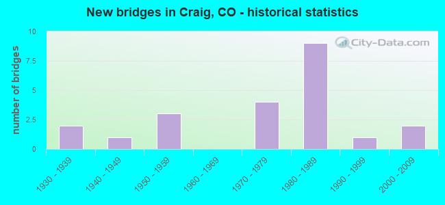
- New bridges - historical statistics
- 21930-1939
- 11940-1949
- 31950-1959
- 41970-1979
- 91980-1989
- 11990-1999
- 22000-2009

- Reconstructed bridges - Historical Statistics
- 21970-1979
- 11980-1989
- 01990-1999
- 12000-2009


- Bridge Condition - Deck
- 7.7%Very good
- 38.5%Good
- 30.8%Satisfactory
- 23.1%Fair

- Bridge Condition - Superstructure
- 7.7%Very good
- 23.1%Good
- 38.5%Satisfactory
- 30.8%Fair

- Bridge Condition - Substructure
- 46.2%Good
- 53.8%Satisfactory

- Bridge Condition - Channel
- 38.1%Very good
- 23.8%Good
- 33.3%Satisfactory
- 4.8%Fair

- Bridge Condition - Culverts
- 33.3%Good
- 33.3%Satisfactory
- 33.3%Fair
Find on map >> Show street view
Structure Number: B-06-A, Location: IN CRAIG (Lat: 40.514194, Lng: -107.541797), Route carried "on" structure: US 40Z, Year Built: 1952, Status: Open, Structure Length: 3.31m (10.86ft), Average Daily Traffic: 3,000 (year 2020), Truck Traffic: 3%, Average Future Daily Traffic: 3,060 (year 2040), Design Load: H 20, Features Intersected: FORTIFICATION CREEK, Facility Carried by Structure: US 40 ML WB
Minimum Vertical Clearance: 30.45m (99.90ft), Kilometerpoint: 0.051, Lanes on structure: 2, Base Highway Network: Yes, Owner: State Highway Agency, Approaching Roadway Width: 12.2m (40.0ft), Skew: 3 degrees, Material/Design: Steel, Design/Construction: Stringer/Multi-beam, Number Of Spans In Main Unit: 2, Length of Maximum Span: 15.2m (49.9ft), Curb or Sidewalk Widths: Left: 1.5m (4.9ft), Right: 1.5m (4.9ft), Curb-To-Curb Width: 9.1m (29.9ft), Out-to-Out Width: 12.2m (40.0ft)
Condition: Deck: Good, Superstructure: Satisfactory, Substructure: Satisfactory, Channel: Very good, Operating Rating: 37.2 metric tons, Method Used To Determine Operating Rating: Load Factor (LF), Inventory Rating: 22.7 metric tons, Method Used To Determine Inventory Rating: Load Factor (LF), Structural Evaluation: Equal to present minimum criteria, Deck Geometry: Meets minimum limits, Waterway Adequacy: Equal to present desirable criteria, Approach Roadway Alignment: Equal to present desirable criteria, Length Of Structure Improvement: 4.20m (13.78ft), Designated Inspection Frequency: Every 24 months, Inspection Date: May 2020, Bridge Improvement Cost: $389,000, Roadway Improvement Cost: $39,000, Total Project Cost: $427,000 ( Estimate for 2020), Deck Structure Type: Concrete Cast-file-Place, Wearing Surface/Protective System: Wearing Surface: Bituminous
Find on map >> Show street view
Structure Number: B-06-B, Location: 3.2 MI NORTH OF CRAIG (Lat: 40.551142, Lng: -107.526297), Route carried "on" structure: State highway 13B, Year Built: 2006, Status: Open, Structure Length: 0.88m (2.89ft), Average Daily Traffic: 2,000 (year 2020), Truck Traffic: 14%, Average Future Daily Traffic: 2,520 (year 2040), Features Intersected: DRAW, Facility Carried by Structure: SH 13 ML
Minimum Vertical Clearance: 30+ m (98+ ft), Kilometerpoint: 5.358, Lanes on structure: 2, Base Highway Network: Yes, Owner: State Highway Agency, Approaching Roadway Width: 9.1m (29.9ft), Material/Design: Concrete, Design/Construction: Culvert, Number Of Spans In Main Unit: 2, Length of Maximum Span: 4.3m (14.1ft), Out-to-Out Width: 25.0m (82.0ft)
Condition: Channel: Very good, Culverts: Good, Structural Evaluation: Better than present minimum criteria, Waterway Adequacy: Superior to present desirable criteria, Approach Roadway Alignment: Equal to present desirable criteria, Designated Inspection Frequency: Every 24 months, Inspection Date: August 2020
Find on map >> Show street view
Structure Number: B-06-S, Location: IN CRAIG (Lat: 40.513481, Lng: -107.541192), Route carried "on" structure: US 40A, Year Built: 1977, Status: Open, Structure Length: 4.19m (13.75ft), Average Daily Traffic: 2,500 (year 2020), Truck Traffic: 6%, Average Future Daily Traffic: 2,675 (year 2040), Design Load: HS 20+Mod, Features Intersected: FORTIFICATION CREEK, Facility Carried by Structure: US 40 ML EBND
Minimum Vertical Clearance: 30.45m (99.90ft), Kilometerpoint: 145.879, Lanes on structure: 2, Base Highway Network: Yes, Owner: State Highway Agency, Approaching Roadway Width: 13.4m (44.0ft), Skew: 5 degrees, Material/Design: Concrete continuous, Design/Construction: Tee Beam, Number Of Spans In Main Unit: 3, Length of Maximum Span: 16.2m (53.1ft), Curb or Sidewalk Widths: Left: 0.0m, Right: 1.5m (4.9ft), Curb-To-Curb Width: 13.4m (44.0ft), Out-to-Out Width: 15.7m (51.5ft)
Condition: Deck: Good, Superstructure: Good, Substructure: Good, Channel: Very good, Operating Rating: 53.5 metric tons, Method Used To Determine Operating Rating: Load Factor (LF), Inventory Rating: 31.8 metric tons, Method Used To Determine Inventory Rating: Load Factor (LF), Structural Evaluation: Better than present minimum criteria, Deck Geometry: Superior to present desirable criteria, Waterway Adequacy: Equal to present desirable criteria, Approach Roadway Alignment: Equal to present desirable criteria, Designated Inspection Frequency: Every 24 months, Inspection Date: May 2020, Deck Structure Type: Other, Wearing Surface/Protective System: Wearing Surface: Bituminous
Find on map >> Show street view
Structure Number: B-06-V, Location: 1 M SO OF CRAIG (Lat: 40.499675, Lng: -107.552833), Route carried "on" structure: State highway 394A, Year Built: 1985, Status: Open, Structure Length: 7.71m (25.30ft), Average Daily Traffic: 3,100 (year 2020), Truck Traffic: 6%, Average Future Daily Traffic: 3,441 (year 2040), Design Load: HS 20+Mod, Features Intersected: YAMPA RIVER, Facility Carried by Structure: SH 394 ML
Minimum Vertical Clearance: 30.45m (99.90ft), Kilometerpoint: 1.619, Lanes on structure: 2, Owner: State Highway Agency, Approaching Roadway Width: 11.6m (38.1ft), Skew: 1 degrees, Material/Design: Prestressed concrete continuous, Design/Construction: Stringer/Multi-beam, Number Of Spans In Main Unit: 2, Length of Maximum Span: 37.8m (124.0ft), Curb or Sidewalk Widths: Left: 0.0m, Right: 2.4m (7.9ft), Curb-To-Curb Width: 12.2m (40.0ft), Out-to-Out Width: 15.6m (51.2ft)
Condition: Deck: Good, Superstructure: Good, Substructure: Good, Channel: Fair, Operating Rating: 82.3 metric tons, Method Used To Determine Operating Rating: Load Factor (LF), Inventory Rating: 47.4 metric tons, Method Used To Determine Inventory Rating: Load Factor (LF), Structural Evaluation: Better than present minimum criteria, Deck Geometry: Equal to present minimum criteria, Waterway Adequacy: Equal to present desirable criteria, Approach Roadway Alignment: Equal to present desirable criteria, Designated Inspection Frequency: Every 24 months, Inspection Date: May 2020, Deck Structure Type: Concrete Cast-file-Place, Wearing Surface/Protective System: Wearing Surface: Bituminous, Membrane: Preformed Fabric
Find on map >> Show street view
Structure Number: B-06-W, Location: 4.9 MI NORTH OF CRAIG (Lat: 40.565250, Lng: -107.506333), Route carried "on" structure: State highway 13B, Year Built: 1986, Status: Open, Structure Length: 1.69m (5.54ft), Average Daily Traffic: 2,000 (year 2020), Truck Traffic: 14%, Average Future Daily Traffic: 2,520 (year 2040), Design Load: HS 20+Mod, Features Intersected: SAND GULCH, Facility Carried by Structure: SH 13 ML
Minimum Vertical Clearance: 30+ m (98+ ft), Kilometerpoint: 7.706, Lanes on structure: 2, Base Highway Network: Yes, Owner: State Highway Agency, Approaching Roadway Width: 9.1m (29.9ft), Material/Design: Concrete, Design/Construction: Culvert, Number Of Spans In Main Unit: 3, Length of Maximum Span: 5.5m (18.0ft), Curb-To-Curb Width: 12.4m (40.7ft), Out-to-Out Width: 13.2m (43.3ft)
Condition: Channel: Very good, Culverts: Satisfactory, Operating Rating: 36.3 metric tons, Method Used To Determine Operating Rating: Field evaluation and documented engineering judgment, Inventory Rating: 32.7 metric tons, Method Used To Determine Inventory Rating: Field evaluation and documented engineering judgment, Structural Evaluation: Equal to present minimum criteria, Deck Geometry: Better than present minimum criteria, Waterway Adequacy: Equal to present desirable criteria, Approach Roadway Alignment: Equal to present desirable criteria, Designated Inspection Frequency: Every 48 months, Inspection Date: July 2018
Find on map >> Show street view
Structure Number: C-06-D, Location: 2 MI S. OF CRAIG (Lat: 40.484500, Lng: -107.607100), Route carried "on" structure: State highway 13A, Year Built: 1972, Status: Open, Structure Length: 11.53m (37.83ft), Average Daily Traffic: 2,800 (year 2020), Truck Traffic: 14%, Average Future Daily Traffic: 3,248 (year 2040), Design Load: HS 20+Mod, Features Intersected: YAMPA RIVER, Facility Carried by Structure: SH 13 ML
Minimum Vertical Clearance: 30+ m (98+ ft), Kilometerpoint: 139.068, Lanes on structure: 2, Base Highway Network: Yes, Owner: State Highway Agency, Approaching Roadway Width: 13.4m (44.0ft), Skew: 3 degrees, Material/Design: Prestressed concrete, Design/Construction: Stringer/Multi-beam, Number Of Spans In Main Unit: 4, Length of Maximum Span: 28.0m (91.9ft), Curb-To-Curb Width: 13.4m (44.0ft), Out-to-Out Width: 14.1m (46.3ft)
Condition: Deck: Satisfactory, Superstructure: Satisfactory, Substructure: Satisfactory, Channel: Very good, Operating Rating: 62.6 metric tons, Method Used To Determine Operating Rating: Load Factor (LF), Inventory Rating: 37.2 metric tons, Method Used To Determine Inventory Rating: Load Factor (LF), Structural Evaluation: Equal to present minimum criteria, Deck Geometry: Better than present minimum criteria, Waterway Adequacy: Superior to present desirable criteria, Approach Roadway Alignment: Equal to present desirable criteria, Designated Inspection Frequency: Every 24 months, Underwater Inspection Frequency: Every 60 months, Inspection Date: August 2020, Underwater Inspection Date: July 2020, Deck Structure Type: Concrete Cast-file-Place, Wearing Surface/Protective System: Wearing Surface: Bituminous, Membrane: Built-up
Find on map >> Show street view
Structure Number: C-06-P, Location: SW EDGE OF CRAIG (Lat: 40.509000, Lng: -107.579300), Route carried "on" structure: State highway 13A, Year Built: 1973, Status: Open, Structure Length: 1.33m (4.36ft), Average Daily Traffic: 2,800 (year 2020), Truck Traffic: 14%, Average Future Daily Traffic: 3,248 (year 2040), Design Load: HS 20, Features Intersected: PINE RIDGE GULCH, Facility Carried by Structure: SH 13 ML
Minimum Vertical Clearance: 30.45m (99.90ft), Kilometerpoint: 142.762, Lanes on structure: 5, Base Highway Network: Yes, Owner: State Highway Agency, Approaching Roadway Width: 21.3m (69.9ft), Material/Design: Concrete, Design/Construction: Culvert, Number Of Spans In Main Unit: 3, Length of Maximum Span: 4.9m (16.1ft), Out-to-Out Width: 32.6m (107.0ft)
Condition: Channel: Satisfactory, Culverts: Satisfactory, Structural Evaluation: Equal to present minimum criteria, Waterway Adequacy: Equal to present desirable criteria, Approach Roadway Alignment: Equal to present desirable criteria, Designated Inspection Frequency: Every 24 months, Inspection Date: May 2020
Find on map >> Show street view
Structure Number: C-06-R, Location: 2.7 Mi West of Craig (Lat: 40.482500, Lng: -107.609600), Route carried "on" structure: Spur State highway 13A, Year Built: 1978, Status: Open, Structure Length: 4.28m (14.04ft), Average Daily Traffic: 2,800 (year 2020), Truck Traffic: 14%, Average Future Daily Traffic: 3,248 (year 2040), Design Load: HS 20+Mod, Features Intersected: RR SPUR, Facility Carried by Structure: SH 13 ML
Minimum Vertical Clearance: 30.45m (99.90ft), Kilometerpoint: 138.759, Lanes on structure: 2, Base Highway Network: Yes, Owner: State Highway Agency, Approaching Roadway Width: 12.2m (40.0ft), Skew: 6 degrees, Material/Design: Steel continuous, Design/Construction: Stringer/Multi-beam, Number Of Spans In Main Unit: 3, Length of Maximum Span: 16.9m (55.4ft), Curb-To-Curb Width: 13.4m (44.0ft), Out-to-Out Width: 14.2m (46.6ft)
Condition: Deck: Good, Superstructure: Very good, Substructure: Satisfactory, Operating Rating: 39.7 metric tons, Method Used To Determine Operating Rating: Load Factor (LF), Inventory Rating: 23.8 metric tons, Method Used To Determine Inventory Rating: Load Factor (LF), Structural Evaluation: Equal to present minimum criteria, Deck Geometry: Better than present minimum criteria, Underclear: Somewhat better than minimum adequacy, Approach Roadway Alignment: Equal to present desirable criteria, Designated Inspection Frequency: Every 24 months, Inspection Date: May 2020, Deck Structure Type: Concrete Cast-file-Place, Wearing Surface/Protective System: Wearing Surface: Bituminous
Find on map >> Show street view
Structure Number: CRAIG-10TH ST, Location: 50 Ft E of Rose Street (Lat: 40.523389, Lng: -107.543417), Route carried "on" structure: City street , Year Built: 1986, Status: Open, Structure Length: 2.19m (7.19ft), Average Daily Traffic: 1,961 (year 2021), Truck Traffic: 22%, Average Future Daily Traffic: 2,294 (year 2041), Design Load: HS 20, Features Intersected: Fortification Creek, Facility Carried by Structure: Tenth Street
Minimum Vertical Clearance: 30+ m (98+ ft), Kilometerpoint: 0.021, Lanes on structure: 3, Owner: City or Municipal Highway Agency, Approaching Roadway Width: 11.0m (36.1ft), Material/Design: Prestressed concrete, Design/Construction: Tee Beam, Number Of Spans In Main Unit: 1, Length of Maximum Span: 20.7m (67.9ft), Curb or Sidewalk Widths: Left: 1.5m (4.9ft), Right: 1.5m (4.9ft), Curb-To-Curb Width: 11.3m (37.1ft), Out-to-Out Width: 14.3m (46.9ft)
Condition: Deck: Satisfactory, Superstructure: Satisfactory, Substructure: Good, Channel: Very good, Operating Rating: 36.3 metric tons, Method Used To Determine Operating Rating: Field evaluation and documented engineering judgment, Inventory Rating: 32.7 metric tons, Method Used To Determine Inventory Rating: Field evaluation and documented engineering judgment, Structural Evaluation: Equal to present minimum criteria, Deck Geometry: High priority of replacement, Waterway Adequacy: Equal to present desirable criteria, Approach Roadway Alignment: Better than present minimum criteria, Length Of Structure Improvement: 2.07m (6.79ft), Designated Inspection Frequency: Every 24 months, Inspection Date: October 2021, Bridge Improvement Cost: $280,000, Roadway Improvement Cost: $28,000, Total Project Cost: $308,000 ( Estimate for 2017), Deck Structure Type: Concrete Cast-file-Place, Wearing Surface/Protective System: Wearing Surface: Bituminous
Find on map >> Show street view
Structure Number: CRAIG-13TH ST, Location: 100 Ft E of Yampa Avenue (Lat: 40.528694, Lng: -107.546083), Route carried "on" structure: City street , Year Built: 1939, Status: Open, Structure Length: 2.52m (8.27ft), Average Daily Traffic: 837 (year 2021), Truck Traffic: 22%, Average Future Daily Traffic: 979 (year 2041), Design Load: HS 20, Features Intersected: Fortification Creek, Facility Carried by Structure: Thirteenth Street
Minimum Vertical Clearance: 30+ m (98+ ft), Kilometerpoint: 0.558, Lanes on structure: 2, Owner: City or Municipal Highway Agency, Approaching Roadway Width: 7.3m (24.0ft), Material/Design: Steel, Design/Construction: Girder and Floorbeam System, Number Of Spans In Main Unit: 1, Length of Maximum Span: 23.2m (76.1ft), Curb-To-Curb Width: 8.4m (27.6ft), Out-to-Out Width: 8.8m (28.9ft)
Condition: Deck: Fair, Superstructure: Fair, Substructure: Satisfactory, Channel: Good, Operating Rating: 27.9 metric tons, Method Used To Determine Operating Rating: Load Factor (LF), Inventory Rating: 16.7 metric tons, Method Used To Determine Inventory Rating: Load Factor (LF), Structural Evaluation: Meets minimum limits, Deck Geometry: Somewhat better than minimum adequacy, Waterway Adequacy: Better than present minimum criteria, Approach Roadway Alignment: Equal to present desirable criteria, Designated Inspection Frequency: Every 24 months, Critical Feature Inspection Frequency: Every 24 months, Inspection Date: October 2021, Critical Feature Inspection Date: October 2021, Deck Structure Type: Corrugated Steel, Wearing Surface/Protective System: Wearing Surface: Bituminous
Find on map >> Show street view
Structure Number: CRAIG-4.0TH ST, Location: 500 Ft E of Lincoln St. (Lat: 40.512394, Lng: -107.539267), Route carried "on" structure: City street , Year Built: 1985, Status: Open, Structure Length: 2.32m (7.61ft), Average Daily Traffic: 742 (year 2021), Truck Traffic: 31%, Average Future Daily Traffic: 868 (year 2041), Design Load: HS 20, Features Intersected: Fortification Creek, Facility Carried by Structure: Fourth Street
Minimum Vertical Clearance: 30+ m (98+ ft), Kilometerpoint: 0.166, Lanes on structure: 2, Owner: City or Municipal Highway Agency, Approaching Roadway Width: 9.1m (29.9ft), Skew: 3 degrees, Material/Design: Prestressed concrete, Design/Construction: Tee Beam, Number Of Spans In Main Unit: 1, Length of Maximum Span: 21.8m (71.5ft), Curb or Sidewalk Widths: Left: 1.3m (4.3ft), Right: 1.3m (4.3ft), Curb-To-Curb Width: 9.1m (29.9ft), Out-to-Out Width: 11.7m (38.4ft)
Condition: Deck: Satisfactory, Superstructure: Satisfactory, Substructure: Satisfactory, Channel: Good, Operating Rating: 74.1 metric tons, Method Used To Determine Operating Rating: Load Factor (LF), Inventory Rating: 34.1 metric tons, Method Used To Determine Inventory Rating: Load Factor (LF), Structural Evaluation: Equal to present minimum criteria, Deck Geometry: Equal to present minimum criteria, Waterway Adequacy: Equal to present desirable criteria, Approach Roadway Alignment: Equal to present desirable criteria, Designated Inspection Frequency: Every 24 months, Inspection Date: October 2021, Deck Structure Type: Other, Wearing Surface/Protective System: Wearing Surface: Bituminous, Membrane: Built-up
Find on map >> Show street view
Structure Number: CRAIG-7.0TH ST, Location: 50 Ft W of Lincoln St. (Lat: 40.517944, Lng: -107.541444), Route carried "on" structure: City street , Year Built: 1985, Status: Open, Structure Length: 2.56m (8.40ft), Average Daily Traffic: 2,503 (year 2021), Truck Traffic: 14%, Average Future Daily Traffic: 2,929 (year 2041), Design Load: HS 20, Features Intersected: Fortification Creek, Facility Carried by Structure: Seventh Street
Minimum Vertical Clearance: 30+ m (98+ ft), Kilometerpoint: 1.246, Lanes on structure: 2, Owner: City or Municipal Highway Agency, Approaching Roadway Width: 11.0m (36.1ft), Skew: 3 degrees, Material/Design: Steel, Design/Construction: Stringer/Multi-beam, Number Of Spans In Main Unit: 1, Length of Maximum Span: 23.7m (77.8ft), Curb-To-Curb Width: 10.7m (35.1ft), Out-to-Out Width: 11.0m (36.1ft)
Condition: Deck: Good, Superstructure: Good, Substructure: Good, Channel: Very good, Operating Rating: 35.2 metric tons, Method Used To Determine Operating Rating: Load Factor (LF), Inventory Rating: 21.1 metric tons, Method Used To Determine Inventory Rating: Load Factor (LF), Structural Evaluation: Somewhat better than minimum adequacy, Deck Geometry: Somewhat better than minimum adequacy, Waterway Adequacy: Equal to present desirable criteria, Approach Roadway Alignment: Equal to present desirable criteria, Designated Inspection Frequency: Every 24 months, Inspection Date: October 2021, Deck Structure Type: Concrete Cast-file-Place, Wearing Surface/Protective System: Wearing Surface: Bituminous
Find on map >> Show street view
Structure Number: CRAIG-COLLEGEDR, Location: 50 Ft. S of First Street (Lat: 40.510167, Lng: -107.581667), Route carried "on" structure: City street , Year Built: 1995, Status: Open, Structure Length: 1.15m (3.77ft), Average Daily Traffic: 155 (year 2021), Truck Traffic: 35%, Average Future Daily Traffic: 181 (year 2041), Design Load: HS 20, Features Intersected: Pine Ridge Gulch, Facility Carried by Structure: College Avenue
Minimum Vertical Clearance: 30+ m (98+ ft), Kilometerpoint: 0.842, Lanes on structure: 2, Owner: City or Municipal Highway Agency, Approaching Roadway Width: 12.8m (42.0ft), Material/Design: Concrete, Design/Construction: Culvert, Number Of Spans In Main Unit: 3, Length of Maximum Span: 3.7m (12.1ft), Curb or Sidewalk Widths: Left: 0.0m, Right: 1.7m (5.6ft), Curb-To-Curb Width: 14.3m (46.9ft), Out-to-Out Width: 20.1m (65.9ft)
Condition: Channel: Satisfactory, Culverts: Good, Operating Rating: 95.3 metric tons, Method Used To Determine Operating Rating: Load Factor (LF), Inventory Rating: 57.2 metric tons, Method Used To Determine Inventory Rating: Load Factor (LF), Structural Evaluation: Better than present minimum criteria, Deck Geometry: Superior to present desirable criteria, Waterway Adequacy: Equal to present desirable criteria, Approach Roadway Alignment: Better than present minimum criteria, Designated Inspection Frequency: Every 24 months, Inspection Date: October 2021
Find on map >> Show street view
Structure Number: CRAIG-COMMERCE, Location: 60 Ft S of First Street (Lat: 40.507972, Lng: -107.577694), Route carried "on" structure: City street , Year Built: 1980, Status: Open, Structure Length: 1.39m (4.56ft), Average Daily Traffic: 536 (year 2021), Truck Traffic: 44%, Average Future Daily Traffic: 627 (year 2041), Features Intersected: Pine Ridge Gulch, Facility Carried by Structure: Commerce Street
Minimum Vertical Clearance: 30+ m (98+ ft), Kilometerpoint: 0.091, Lanes on structure: 2, Owner: City or Municipal Highway Agency, Approaching Roadway Width: 11.4m (37.4ft), Material/Design: Steel, Design/Construction: Culvert, Number Of Spans In Main Unit: 7, Length of Maximum Span: 1.5m (4.9ft), Curb or Sidewalk Widths: Left: 1.0m (3.3ft), Right: 1.1m (3.6ft), Out-to-Out Width: 19.8m (65.0ft)
Condition: Channel: Satisfactory, Culverts: Fair, Operating Rating: 84.0 metric tons, Method Used To Determine Operating Rating: Load Factor (LF), Inventory Rating: 50.3 metric tons, Method Used To Determine Inventory Rating: Load Factor (LF), Structural Evaluation: Somewhat better than minimum adequacy, Waterway Adequacy: Better than present minimum criteria, Approach Roadway Alignment: Equal to present desirable criteria, Designated Inspection Frequency: Every 24 months, Inspection Date: October 2021
Find on map >> Show street view
Structure Number: CRAIG-DOUGLAS-A, Location: 80 Ft S of First Street (Lat: 40.510806, Lng: -107.584556), Route carried "on" structure: City street , Year Built: 1980, Year Reconstructed: 1994, Status: Open, Structure Length: 1.50m (4.92ft), Average Daily Traffic: 430 (year 2021), Truck Traffic: 8%, Average Future Daily Traffic: 503 (year 2041), Design Load: HS 20, Features Intersected: Pine Ridge Gulch, Facility Carried by Structure: Douglas Street
Minimum Vertical Clearance: 30+ m (98+ ft), Kilometerpoint: 0.177, Lanes on structure: 2, Owner: City or Municipal Highway Agency, Approaching Roadway Width: 11.6m (38.1ft), Material/Design: Steel, Design/Construction: Culvert, Number Of Spans In Main Unit: 8, Length of Maximum Span: 1.5m (4.9ft), Curb or Sidewalk Widths: Left: 1.6m (5.2ft), Right: 1.6m (5.2ft), Curb-To-Curb Width: 11.7m (38.4ft), Out-to-Out Width: 23.1m (75.8ft)
Condition: Channel: Satisfactory, Culverts: Fair, Inventory Rating: 62.4 metric tons, Method Used To Determine Inventory Rating: Load Factor (LF), Structural Evaluation: Somewhat better than minimum adequacy, Deck Geometry: Better than present minimum criteria, Waterway Adequacy: Better than present minimum criteria, Approach Roadway Alignment: Better than present minimum criteria, Designated Inspection Frequency: Every 24 months, Inspection Date: October 2021
Find on map >> Show street view
Structure Number: CRAIG-DOYAN, Location: 30 Ft S of First Street (Lat: 40.506750, Lng: -107.573528), Route carried "on" structure: City street , Year Built: 1983, Status: Open, Structure Length: 1.67m (5.48ft), Average Daily Traffic: 1,457 (year 2021), Truck Traffic: 36%, Average Future Daily Traffic: 1,705 (year 2041), Design Load: HS 20, Features Intersected: Pine Ridge Gulch, Facility Carried by Structure: Doyan Avenue
Minimum Vertical Clearance: 30+ m (98+ ft), Kilometerpoint: 1.106, Lanes on structure: 2, Owner: City or Municipal Highway Agency, Approaching Roadway Width: 7.3m (24.0ft), Material/Design: Prestressed concrete, Design/Construction: Tee Beam, Number Of Spans In Main Unit: 2, Length of Maximum Span: 7.8m (25.6ft), Curb or Sidewalk Widths: Left: 0.9m (3.0ft), Right: 0.9m (3.0ft), Curb-To-Curb Width: 8.6m (28.2ft), Out-to-Out Width: 11.0m (36.1ft)
Condition: Deck: Fair, Superstructure: Satisfactory, Substructure: Good, Channel: Satisfactory, Operating Rating: 52.3 metric tons, Method Used To Determine Operating Rating: Load Factor (LF), Inventory Rating: 32.3 metric tons, Method Used To Determine Inventory Rating: Load Factor (LF), Structural Evaluation: Equal to present minimum criteria, Deck Geometry: Somewhat better than minimum adequacy, Waterway Adequacy: Equal to present desirable criteria, Approach Roadway Alignment: Equal to present desirable criteria, Designated Inspection Frequency: Every 24 months, Inspection Date: October 2021, Deck Structure Type: Other, Wearing Surface/Protective System: Wearing Surface: Monolithic Concrete
Find on map >> Show street view
Structure Number: CRAIG-FIRST ST, Location: 50 Ft West of St Hwy 13 (Lat: 40.509500, Lng: -107.579278), Route carried "on" structure: City street , Year Built: 1980, Status: Open, Structure Length: 1.07m (3.51ft), Average Daily Traffic: 988 (year 2021), Truck Traffic: 16%, Average Future Daily Traffic: 1,156 (year 2041), Design Load: HS 20, Features Intersected: Cedar Mountain Gulch, Facility Carried by Structure: First Street
Minimum Vertical Clearance: 30+ m (98+ ft), Kilometerpoint: 0.515, Lanes on structure: 2, Owner: City or Municipal Highway Agency, Approaching Roadway Width: 14.5m (47.6ft), Material/Design: Steel, Design/Construction: Culvert, Number Of Spans In Main Unit: 6, Length of Maximum Span: 1.4m (4.6ft), Out-to-Out Width: 32.2m (105.6ft)
Condition: Channel: Satisfactory, Culverts: Fair, Structural Evaluation: Somewhat better than minimum adequacy, Waterway Adequacy: Equal to present desirable criteria, Approach Roadway Alignment: Better than present minimum criteria, Designated Inspection Frequency: Every 24 months, Inspection Date: October 2021
Find on map >> Show street view
Structure Number: MOF112-00.22, Location: 0.22 Mi So. St Hwy 13 (Lat: 40.547611, Lng: -107.528889), Route carried "on" structure: County highway , Year Built: 1950, Year Reconstructed: 1978, Status: Open, Structure Length: 1.05m (3.44ft), Average Daily Traffic: 243 (year 2021), Truck Traffic: 38%, Average Future Daily Traffic: 284 (year 2041), Design Load: HS 20, Features Intersected: Fortification Creek, Facility Carried by Structure: County Road 112
Minimum Vertical Clearance: 30+ m (98+ ft), Kilometerpoint: 2.709, Lanes on structure: 2, Owner: County Highway Agency, Approaching Roadway Width: 6.1m (20.0ft), Skew: 2 degrees, Material/Design: Steel, Design/Construction: Stringer/Multi-beam, Number Of Spans In Main Unit: 1, Length of Maximum Span: 9.7m (31.8ft), Curb-To-Curb Width: 7.3m (24.0ft), Out-to-Out Width: 7.3m (24.0ft)
Condition: Deck: Satisfactory, Superstructure: Fair, Substructure: Satisfactory, Channel: Good, Operating Rating: 35.8 metric tons, Method Used To Determine Operating Rating: Load Factor (LF), Inventory Rating: 21.5 metric tons, Method Used To Determine Inventory Rating: Load Factor (LF), Structural Evaluation: Somewhat better than minimum adequacy, Deck Geometry: Somewhat better than minimum adequacy, Waterway Adequacy: Equal to present desirable criteria, Approach Roadway Alignment: Equal to present desirable criteria, Designated Inspection Frequency: Every 24 months, Inspection Date: October 2021, Deck Structure Type: Corrugated Steel, Wearing Surface/Protective System: Wearing Surface: Gravel
Find on map >> Show street view
Structure Number: MOF1STST-00.25, Location: 0.7 Mi East of St Hwy 394 (Lat: 40.506833, Lng: -107.539306), Route carried "on" structure: County highway , Year Built: 1939, Year Reconstructed: 1978, Status: Open, Structure Length: 2.54m (8.33ft), Average Daily Traffic: 2,270 (year 2021), Truck Traffic: 40%, Average Future Daily Traffic: 2,656 (year 2041), Design Load: H 15, Features Intersected: Fortification Creek, Facility Carried by Structure: First Street
Minimum Vertical Clearance: 30+ m (98+ ft), Kilometerpoint: 1.241, Lanes on structure: 2, Owner: County Highway Agency, Approaching Roadway Width: 7.3m (24.0ft), Material/Design: Steel, Design/Construction: Girder and Floorbeam System, Number Of Spans In Main Unit: 1, Length of Maximum Span: 22.6m (74.1ft), Curb-To-Curb Width: 8.4m (27.6ft), Out-to-Out Width: 8.8m (28.9ft)
Condition: Deck: Fair, Superstructure: Fair, Substructure: Good, Channel: Very good, Operating Rating: 28.2 metric tons, Method Used To Determine Operating Rating: Load Factor (LF), Inventory Rating: 16.9 metric tons, Method Used To Determine Inventory Rating: Load Factor (LF), Structural Evaluation: Meets minimum limits, Deck Geometry: High priority of corrective action, Waterway Adequacy: Better than present minimum criteria, Approach Roadway Alignment: Equal to present desirable criteria, Designated Inspection Frequency: Every 24 months, Critical Feature Inspection Frequency: Every 24 months, Inspection Date: October 2021, Critical Feature Inspection Date: October 2021, Deck Structure Type: Corrugated Steel, Wearing Surface/Protective System: Wearing Surface: Bituminous
Find on map >> Show street view
Structure Number: MOF7-00.53, Location: 0.53 Mi North US Hwy 40 (Lat: 40.521444, Lng: -107.576083), Route carried "on" structure: County highway , Year Built: 1950, Year Reconstructed: 2007, Status: Open, Structure Length: 0.91m (2.99ft), Average Daily Traffic: 4,339 (year 2021), Truck Traffic: 41%, Average Future Daily Traffic: 5,077 (year 2041), Features Intersected: Cedar Mountain Gulch, Facility Carried by Structure: County Road 7
Minimum Vertical Clearance: 30+ m (98+ ft), Kilometerpoint: 0.583, Lanes on structure: 3, Owner: County Highway Agency, Approaching Roadway Width: 14.3m (46.9ft), Skew: 4 degrees, Material/Design: Steel, Design/Construction: Culvert, Number Of Spans In Main Unit: 3, Length of Maximum Span: 2.3m (7.5ft), Out-to-Out Width: 25.4m (83.3ft)
Condition: Channel: Good, Culverts: Satisfactory, Structural Evaluation: Equal to present minimum criteria, Waterway Adequacy: Better than present minimum criteria, Approach Roadway Alignment: Equal to present desirable criteria, Designated Inspection Frequency: Every 24 months, Inspection Date: October 2021
Find on map >> Show street view
Structure Number: MOFHLRD-00.1, Location: .10 Mi West of CR7 (Lat: 40.516306, Lng: -107.575750), Route carried "on" structure: County highway , Year Built: 2008, Status: Open, Structure Length: 0.87m (2.85ft), Average Daily Traffic: 1,171 (year 2021), Truck Traffic: 13%, Average Future Daily Traffic: 1,370 (year 2041), Design Load: HS 20, Features Intersected: Cedar Mountain Gulch, Facility Carried by Structure: Hospital Loop Road
Minimum Vertical Clearance: 30+ m (98+ ft), Kilometerpoint: 0.755, Lanes on structure: 2, Owner: County Highway Agency, Approaching Roadway Width: 12.2m (40.0ft), Skew: 2 degrees, Material/Design: Concrete, Design/Construction: Culvert, Number Of Spans In Main Unit: 2, Length of Maximum Span: 4.0m (13.1ft), Curb or Sidewalk Widths: Left: 1.2m (3.9ft), Right: 1.2m (3.9ft), Curb-To-Curb Width: 12.2m (40.0ft), Out-to-Out Width: 19.6m (64.3ft)
Condition: Channel: Good, Culverts: Good, Operating Rating: 52.3 metric tons, Method Used To Determine Operating Rating: Load Factor (LF), Inventory Rating: 31.3 metric tons, Method Used To Determine Inventory Rating: Load Factor (LF), Structural Evaluation: Better than present minimum criteria, Deck Geometry: Better than present minimum criteria, Waterway Adequacy: Equal to present desirable criteria, Approach Roadway Alignment: Equal to present desirable criteria, Designated Inspection Frequency: Every 24 months, Inspection Date: October 2021
Find on map >> Show street view
Structure Number: MOFSTCKDR-00.11, Location: 0.2 Mi West of Preese St (Lat: 40.510000, Lng: -107.539083), Route carried "on" structure: County highway , Year Built: 1940, Status: Posted for load-capacity, Structure Length: 2.05m (6.73ft), Average Daily Traffic: 463 (year 2021), Truck Traffic: 42%, Average Future Daily Traffic: 542 (year 2041), Design Load: HS 20, Features Intersected: Fortification Creek, Facility Carried by Structure: Stock Drive
Minimum Vertical Clearance: 30+ m (98+ ft), Kilometerpoint: 0.190, Lanes on structure: 1, Owner: County Highway Agency, Approaching Roadway Width: 4.6m (15.1ft), Material/Design: Steel, Design/Construction: Girder and Floorbeam System, Number Of Spans In Main Unit: 1, Length of Maximum Span: 20.0m (65.6ft), Curb-To-Curb Width: 4.1m (13.5ft), Out-to-Out Width: 4.3m (14.1ft)
Condition: Deck: Very good, Superstructure: Fair, Substructure: Satisfactory, Channel: Satisfactory, Operating Rating: 27.9 metric tons, Method Used To Determine Operating Rating: Load Factor (LF), Inventory Rating: 16.7 metric tons, Method Used To Determine Inventory Rating: Load Factor (LF), Structural Evaluation: Somewhat better than minimum adequacy, Deck Geometry: High priority of replacement, Waterway Adequacy: Equal to present desirable criteria, Approach Roadway Alignment: Equal to present minimum criteria, Bridge Posting: Required (Relationship of Operating Rating to Maximum Legal Load: 0.1 - 9.9% below), Length Of Structure Improvement: 2.83m (9.28ft), Designated Inspection Frequency: Every 24 months, Critical Feature Inspection Frequency: Every 24 months, Inspection Date: October 2021, Critical Feature Inspection Date: October 2021, Bridge Improvement Cost: $341,000, Roadway Improvement Cost: $34,000, Total Project Cost: $375,000 ( Estimate for 2017), Deck Structure Type: Corrugated Steel, Wearing Surface/Protective System: Wearing Surface: Bituminous