Bridge Statistics for Covington, Georgia (GA)
Condition, Traffic, Stress, Structural Evaluation, Project Costs
- National Bridge Inventory (NBI) Statistics
- 44Number of bridges
- 581ft / 177mTotal length
- $147,728,000Total costs
- 882,960Total average daily traffic
- 58,797Total average daily truck traffic
- National Bridge Inventory (NBI) Registered Bridges for Covington
- No street view available for this location
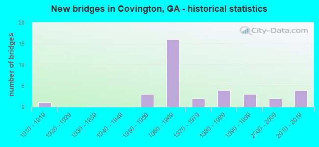
- New bridges - historical statistics
- 11910-1919
- 31950-1959
- 161960-1969
- 21970-1979
- 41980-1989
- 31990-1999
- 22000-2009
- 42010-2019

- Reconstructed bridges - Historical Statistics
- 21980-1989
- 11990-1999
- 62000-2009


- Bridge Condition - Deck
- 12.0%Very good
- 76.0%Good
- 12.0%Satisfactory

- Bridge Condition - Superstructure
- 36.0%Very good
- 48.0%Good
- 16.0%Satisfactory

- Bridge Condition - Substructure
- 8.0%Very good
- 76.0%Good
- 8.0%Satisfactory
- 8.0%Fair

- Bridge Condition - Channel
- 4.0%Excellent
- 36.0%Very good
- 44.0%Good
- 12.0%Satisfactory
- 4.0%Fair

- Bridge Condition - Culverts
- 40.0%Good
- 60.0%Satisfactory
Find on map >> Show street view
Structure Number: 2170002, Location: IN COVINGTON (Lat: 33.602878, Lng: -83.857969), Route carried "on" structure: US 278, Year Built: 1954, Status: Open, Structure Length: 1.13m (3.71ft), Average Daily Traffic: 27,320 (year 2011), Truck Traffic: 1%, Average Future Daily Traffic: 40,980 (year 2031), Design Load: H 15, Features Intersected: DRIED INDIAN CREEK
Minimum Vertical Clearance: 30+ m (98+ ft), Kilometerpoint: 9.656, Lanes on structure: 5, Base Highway Network: Yes, Owner: State Highway Agency, Approaching Roadway Width: 20.7m (67.9ft), Skew: 3 degrees, Material/Design: Concrete, Design/Construction: Culvert, Number Of Spans In Main Unit: 3, Length of Maximum Span: 3.7m (12.1ft)
Condition: Channel: Satisfactory, Culverts: Satisfactory, Operating Rating: 59.8 metric tons, Method Used To Determine Operating Rating: Load Factor (LF), Inventory Rating: 36.2 metric tons, Method Used To Determine Inventory Rating: Load Factor (LF), Structural Evaluation: Equal to present minimum criteria, Waterway Adequacy: Equal to present desirable criteria, Approach Roadway Alignment: Equal to present desirable criteria, Designated Inspection Frequency: Every 24 months, Inspection Date: December 2020, Bridge Improvement Cost: $263,000, Roadway Improvement Cost: $26,000, Total Project Cost: $394,000
Find on map >> Show street view
Structure Number: 217001, Location: 1 MI W OF COVINGTON (Lat: 33.613219, Lng: -83.901008), Route carried "on" structure: County highway 57, Year Built: 1964, Status: Open, Structure Length: 6.46m (21.19ft), Average Daily Traffic: 3,560 (year 2011), Truck Traffic: 1%, Average Future Daily Traffic: 5,340 (year 2031), Design Load: H 15, Features Intersected: I-20, Facility Carried by Structure: OLD OXFORD ROAD
Minimum Vertical Clearance: 30+ m (98+ ft), Kilometerpoint: 0.000, Lanes on structure: 2, Lanes under structure: 6, Base Highway Network: Yes, Owner: State Highway Agency, Approaching Roadway Width: 6.7m (22.0ft), Material/Design: Steel continuous, Design/Construction: Stringer/Multi-beam, Number Of Spans In Main Unit: 4, Length of Maximum Span: 18.0m (59.1ft), Curb or Sidewalk Widths: Left: 0.6m (2.0ft), Right: 0.6m (2.0ft), Curb-To-Curb Width: 7.3m (24.0ft), Out-to-Out Width: 9.2m (30.2ft)
Condition: Deck: Satisfactory, Superstructure: Satisfactory, Substructure: Satisfactory, Operating Rating: 30.8 metric tons, Method Used To Determine Operating Rating: Load Factor (LF), Inventory Rating: 18.1 metric tons, Method Used To Determine Inventory Rating: Load Factor (LF), Structural Evaluation: Somewhat better than minimum adequacy, Deck Geometry: High priority of replacement, Underclear: Meets minimum limits, Approach Roadway Alignment: Equal to present minimum criteria, Length Of Structure Improvement: 46.70m (153.22ft), Designated Inspection Frequency: Every 24 months, Inspection Date: January 2021, Bridge Improvement Cost: $828,000, Roadway Improvement Cost: $83,000, Total Project Cost: $1,242,000, Deck Structure Type: Concrete Cast-file-Place
Find on map >> Show street view
Structure Number: 2170014, Location: IN COVINGTON (Lat: 33.600489, Lng: -83.863889), Route carried "on" structure: State highway 81, Year Built: 1914, Status: Open, Structure Length: 2.53m (8.30ft), Average Daily Traffic: 13,240 (year 2011), Truck Traffic: 1%, Average Future Daily Traffic: 19,860 (year 2031), Design Load: H 15, Features Intersected: DRIED INDIAN CREEK
Minimum Vertical Clearance: 30+ m (98+ ft), Kilometerpoint: 17.703, Lanes on structure: 3, Base Highway Network: Yes, Owner: State Highway Agency, Approaching Roadway Width: 11.9m (39.0ft), Material/Design: Concrete, Design/Construction: Arch - Deck, Number Of Spans In Main Unit: 1, Length of Maximum Span: 25.3m (83.0ft), Curb or Sidewalk Widths: Left: 1.6m (5.2ft), Right: 2.0m (6.6ft), Curb-To-Curb Width: 11.3m (37.1ft), Out-to-Out Width: 15.7m (51.5ft)
Condition: Deck: Good, Superstructure: Satisfactory, Substructure: Good, Channel: Good, Operating Rating: 55.3 metric tons, Method Used To Determine Operating Rating: Allowable Stress (AS), Inventory Rating: 17.2 metric tons, Method Used To Determine Inventory Rating: Allowable Stress (AS), Structural Evaluation: Meets minimum limits, Deck Geometry: High priority of replacement, Waterway Adequacy: Equal to present desirable criteria, Approach Roadway Alignment: Equal to present minimum criteria, Designated Inspection Frequency: Every 24 months, Inspection Date: December 2020, Bridge Improvement Cost: $413,000, Roadway Improvement Cost: $41,000, Total Project Cost: $619,000, Deck Structure Type: Concrete Cast-file-Place, Wearing Surface/Protective System: Wearing Surface: Bituminous
Find on map >> Show street view
Structure Number: 2170015, Location: IN COVINGTON (Lat: 33.609997, Lng: -83.867389), Route carried "on" structure: State highway 81, Year Built: 1964, Status: Open, Structure Length: 7.04m (23.10ft), Average Daily Traffic: 14,150 (year 2011), Truck Traffic: 1%, Average Future Daily Traffic: 21,225 (year 2031), Design Load: HS 20, Features Intersected: I-20
Minimum Vertical Clearance: 30+ m (98+ ft), Kilometerpoint: 19.312, Lanes on structure: 2, Lanes under structure: 6, Base Highway Network: Yes, Owner: State Highway Agency, Approaching Roadway Width: 8.5m (27.9ft), Skew: 2 degrees, Material/Design: Steel, Design/Construction: Stringer/Multi-beam, Number Of Spans In Main Unit: 4, Length of Maximum Span: 19.5m (64.0ft), Curb or Sidewalk Widths: Left: 1.2m (3.9ft), Right: 1.2m (3.9ft), Curb-To-Curb Width: 8.5m (27.9ft), Out-to-Out Width: 11.6m (38.1ft)
Condition: Deck: Satisfactory, Superstructure: Good, Substructure: Good, Operating Rating: 36.2 metric tons, Method Used To Determine Operating Rating: Load Factor (LF), Inventory Rating: 21.7 metric tons, Method Used To Determine Inventory Rating: Load Factor (LF), Structural Evaluation: Somewhat better than minimum adequacy, Deck Geometry: Meets minimum limits, Underclear: Meets minimum limits, Approach Roadway Alignment: Equal to present minimum criteria, Length Of Structure Improvement: 47.27m (155.09ft), Designated Inspection Frequency: Every 24 months, Inspection Date: Febuary 2021, Bridge Improvement Cost: $903,000, Roadway Improvement Cost: $90,000, Total Project Cost: $1,354,000, Deck Structure Type: Concrete Cast-file-Place
Find on map >> Show street view
Structure Number: 217002, Location: 6.5 MI S OF PORTERDALE (Lat: 33.454269, Lng: -83.881028), Route carried "on" structure: State highway 212, Year Built: 1972, Status: Open, Structure Length: 14.02m (46.00ft), Average Daily Traffic: 4,140 (year 2011), Truck Traffic: 1%, Average Future Daily Traffic: 6,210 (year 2031), Design Load: HS 20, Features Intersected: YELLOW RIVER
Minimum Vertical Clearance: 30+ m (98+ ft), Kilometerpoint: 17.703, Lanes on structure: 2, Base Highway Network: Yes, Owner: State Highway Agency, Approaching Roadway Width: 8.5m (27.9ft), Material/Design: Steel, Design/Construction: Stringer/Multi-beam, Number Of Spans In Main Unit: 2, Number Of Approach Spans: 8, Length of Maximum Span: 21.3m (69.9ft), Curb or Sidewalk Widths: Left: 0.2m (0.7ft), Right: 0.2m (0.7ft), Curb-To-Curb Width: 11.8m (38.7ft), Out-to-Out Width: 12.9m (42.3ft)
Condition: Deck: Good, Superstructure: Good, Substructure: Fair, Channel: Very good, Operating Rating: 56.2 metric tons, Method Used To Determine Operating Rating: Allowable Stress (AS), Inventory Rating: 32.6 metric tons, Method Used To Determine Inventory Rating: Allowable Stress (AS), Structural Evaluation: Somewhat better than minimum adequacy, Deck Geometry: Somewhat better than minimum adequacy, Waterway Adequacy: Equal to present desirable criteria, Approach Roadway Alignment: Equal to present minimum criteria, Designated Inspection Frequency: Every 24 months, Underwater Inspection Frequency: Every 60 months, Inspection Date: January 2021, Underwater Inspection Date: September 2018, Bridge Improvement Cost: $1,797,000, Roadway Improvement Cost: $180,000, Total Project Cost: $2,696,000, Deck Structure Type: Concrete Cast-file-Place
Find on map >> Show street view
Structure Number: 2170026, Location: IN COVINGTON (Lat: 33.607208, Lng: -83.875519), Route carried "on" structure: Interstate 20, Year Built: 1964, Year Reconstructed: 1994, Status: Open, Structure Length: 5.76m (18.90ft), Average Daily Traffic: 49,740 (year 2011), Truck Traffic: 1%, Average Future Daily Traffic: 74,610 (year 2031), Design Load: HS 20+Mod, Features Intersected: I-20 RAMP TO SR 12
Minimum Vertical Clearance: 30+ m (98+ ft), Kilometerpoint: 144.841, Lanes on structure: 7, Lanes under structure: 3, Base Highway Network: Yes, Owner: State Highway Agency, Approaching Roadway Width: 32.3m (106.0ft), Skew: 32 degrees, Material/Design: Steel, Design/Construction: Stringer/Multi-beam, Number Of Spans In Main Unit: 4, Length of Maximum Span: 15.8m (51.8ft), Curb-To-Curb Width: 40.9m (134.2ft), Out-to-Out Width: 43.3m (142.1ft)
Condition: Deck: Good, Superstructure: Good, Substructure: Good, Operating Rating: 31.7 metric tons, Method Used To Determine Operating Rating: Load Factor (LF), Inventory Rating: 19.0 metric tons, Method Used To Determine Inventory Rating: Load Factor (LF), Structural Evaluation: Meets minimum limits, Deck Geometry: Superior to present desirable criteria, Underclear: Somewhat better than minimum adequacy, Approach Roadway Alignment: Equal to present desirable criteria, Length Of Structure Improvement: 12.16m (39.90ft), Designated Inspection Frequency: Every 24 months, Inspection Date: January 2021, Bridge Improvement Cost: $1,745,000, Roadway Improvement Cost: $175,000, Total Project Cost: $2,618,000, Deck Structure Type: Concrete Cast-file-Place, Wearing Surface/Protective System: Wearing Surface: Bituminous
Find on map >> Show street view
Structure Number: 2170028, Location: IN COVINGTON (Lat: 33.607608, Lng: -83.873808), Route carried "on" structure: Interstate 20, Year Built: 1964, Year Reconstructed: 1994, Status: Open, Structure Length: 8.08m (26.51ft), Average Daily Traffic: 49,740 (year 2011), Truck Traffic: 1%, Average Future Daily Traffic: 74,610 (year 2031), Design Load: HS 20+Mod, Features Intersected: CR 55 ATLANTA ST- CSX RR
Minimum Vertical Clearance: 30+ m (98+ ft), Kilometerpoint: 144.841, Lanes on structure: 7, Lanes under structure: 2, Base Highway Network: Yes, Owner: State Highway Agency, Approaching Roadway Width: 32.3m (106.0ft), Skew: 34 degrees, Material/Design: Steel, Design/Construction: Stringer/Multi-beam, Number Of Spans In Main Unit: 6, Length of Maximum Span: 16.8m (55.1ft), Curb-To-Curb Width: 36.5m (119.8ft), Out-to-Out Width: 38.5m (126.3ft)
Condition: Deck: Good, Superstructure: Good, Substructure: Good, Operating Rating: 33.5 metric tons, Method Used To Determine Operating Rating: Load Factor (LF), Inventory Rating: 19.9 metric tons, Method Used To Determine Inventory Rating: Load Factor (LF), Structural Evaluation: Somewhat better than minimum adequacy, Deck Geometry: Superior to present desirable criteria, Underclear: Meets minimum limits, Approach Roadway Alignment: Equal to present desirable criteria, Length Of Structure Improvement: 14.51m (47.60ft), Designated Inspection Frequency: Every 24 months, Inspection Date: January 2021, Bridge Improvement Cost: $2,447,000, Roadway Improvement Cost: $245,000, Total Project Cost: $3,671,000, Deck Structure Type: Concrete Cast-file-Place, Wearing Surface/Protective System: Wearing Surface: Bituminous
Find on map >> Show street view
Structure Number: 217003, Location: IN COVINGTON (Lat: 33.615211, Lng: -83.855328), Route carried "on" structure: Interstate 20, Year Built: 1964, Status: Open, Structure Length: 0.64m (2.10ft), Average Daily Traffic: 49,740 (year 2011), Truck Traffic: 1%, Average Future Daily Traffic: 74,610 (year 2031), Design Load: HS 20+Mod, Features Intersected: E FORK DRIED INDIAN CRK
Minimum Vertical Clearance: 30+ m (98+ ft), Kilometerpoint: 148.060, Lanes on structure: 6, Base Highway Network: Yes, Owner: State Highway Agency, Approaching Roadway Width: 39.9m (130.9ft), Skew: 30 degrees, Material/Design: Concrete, Design/Construction: Culvert, Number Of Spans In Main Unit: 2, Length of Maximum Span: 3.0m (9.8ft)
Condition: Channel: Good, Culverts: Satisfactory, Operating Rating: 55.3 metric tons, Method Used To Determine Operating Rating: Load Factor (LF), Inventory Rating: 32.6 metric tons, Method Used To Determine Inventory Rating: Load Factor (LF), Structural Evaluation: Equal to present minimum criteria, Waterway Adequacy: Equal to present minimum criteria, Approach Roadway Alignment: Equal to present desirable criteria, Designated Inspection Frequency: Every 24 months, Inspection Date: January 2021, Bridge Improvement Cost: $172,000, Roadway Improvement Cost: $17,000, Total Project Cost: $257,000
Find on map >> Show street view
Structure Number: 2170033, Location: .5 MI W OF JCT SR 142 (Lat: 33.614919, Lng: -83.834008), Route carried "on" structure: Interstate 20, Year Built: 1964, Year Reconstructed: 2009, Status: Open, Structure Length: 5.43m (17.81ft), Average Daily Traffic: 43,980 (year 2011), Truck Traffic: 1%, Average Future Daily Traffic: 65,970 (year 2031), Design Load: HS 20+Mod, Features Intersected: CSX RAILROAD
Minimum Vertical Clearance: 30+ m (98+ ft), Kilometerpoint: 149.669, Lanes on structure: 3, Base Highway Network: Yes, Owner: State Highway Agency, Approaching Roadway Width: 19.5m (64.0ft), Skew: 13 degrees, Material/Design: Steel, Design/Construction: Stringer/Multi-beam, Number Of Spans In Main Unit: 3, Length of Maximum Span: 18.6m (61.0ft), Curb-To-Curb Width: 20.2m (66.3ft), Out-to-Out Width: 21.1m (69.2ft)
Condition: Deck: Good, Superstructure: Good, Substructure: Good, Operating Rating: 38.1 metric tons, Method Used To Determine Operating Rating: Load Factor (LF), Inventory Rating: 22.6 metric tons, Method Used To Determine Inventory Rating: Load Factor (LF), Structural Evaluation: Somewhat better than minimum adequacy, Deck Geometry: Superior to present desirable criteria, Underclear: Better than present minimum criteria, Approach Roadway Alignment: Equal to present desirable criteria, Designated Inspection Frequency: Every 24 months, Inspection Date: Febuary 2021, Bridge Improvement Cost: $885,000, Roadway Improvement Cost: $89,000, Total Project Cost: $1,328,000, Deck Structure Type: Concrete Cast-file-Place
Find on map >> Show street view
Structure Number: 2170034, Location: .5 MI W OF JCT SR 142 (Lat: 33.615069, Lng: -83.833658), Route carried "on" structure: Interstate 20, Year Built: 1964, Year Reconstructed: 2009, Status: Open, Structure Length: 5.36m (17.59ft), Average Daily Traffic: 43,980 (year 2011), Truck Traffic: 1%, Average Future Daily Traffic: 65,970 (year 2031), Design Load: HS 20+Mod, Features Intersected: CSX RAILROAD
Minimum Vertical Clearance: 30+ m (98+ ft), Kilometerpoint: 149.669, Lanes on structure: 3, Base Highway Network: Yes, Owner: State Highway Agency, Approaching Roadway Width: 20.1m (65.9ft), Skew: 13 degrees, Material/Design: Steel, Design/Construction: Stringer/Multi-beam, Number Of Spans In Main Unit: 3, Length of Maximum Span: 18.3m (60.0ft), Curb-To-Curb Width: 20.1m (65.9ft), Out-to-Out Width: 21.2m (69.6ft)
Condition: Deck: Good, Superstructure: Very good, Substructure: Good, Operating Rating: 37.1 metric tons, Method Used To Determine Operating Rating: Load Factor (LF), Inventory Rating: 21.7 metric tons, Method Used To Determine Inventory Rating: Load Factor (LF), Structural Evaluation: Somewhat better than minimum adequacy, Deck Geometry: Superior to present desirable criteria, Underclear: Better than present minimum criteria, Approach Roadway Alignment: Equal to present desirable criteria, Length Of Structure Improvement: 11.83m (38.81ft), Designated Inspection Frequency: Every 24 months, Inspection Date: Febuary 2021, Bridge Improvement Cost: $875,000, Roadway Improvement Cost: $88,000, Total Project Cost: $1,313,000, Deck Structure Type: Concrete Cast-file-Place
Find on map >> Show street view
Structure Number: 2170035, Location: 2.5 MI E OF COVINGTON (Lat: 33.610844, Lng: -83.806961), Route carried "on" structure: Interstate 20, Year Built: 1964, Year Reconstructed: 2000, Status: Open, Structure Length: 5.85m (19.19ft), Average Daily Traffic: 41,840 (year 2011), Truck Traffic: 17%, Average Future Daily Traffic: 62,760 (year 2031), Design Load: HS 20+Mod, Features Intersected: ALCOVY RIVER TRIB
Minimum Vertical Clearance: 30+ m (98+ ft), Kilometerpoint: 151.278, Lanes on structure: 2, Base Highway Network: Yes, Owner: State Highway Agency, Approaching Roadway Width: 12.5m (41.0ft), Skew: 10 degrees, Material/Design: Steel continuous, Design/Construction: Stringer/Multi-beam, Number Of Spans In Main Unit: 3, Length of Maximum Span: 22.3m (73.2ft), Curb-To-Curb Width: 12.6m (41.3ft), Out-to-Out Width: 13.6m (44.6ft)
Condition: Deck: Good, Superstructure: Good, Substructure: Good, Channel: Very good, Operating Rating: 35.3 metric tons, Method Used To Determine Operating Rating: Load Factor (LF), Inventory Rating: 20.8 metric tons, Method Used To Determine Inventory Rating: Load Factor (LF), Structural Evaluation: Somewhat better than minimum adequacy, Deck Geometry: Better than present minimum criteria, Waterway Adequacy: Equal to present minimum criteria, Approach Roadway Alignment: Equal to present desirable criteria, Length Of Structure Improvement: 12.28m (40.29ft), Designated Inspection Frequency: Every 24 months, Inspection Date: Febuary 2021, Bridge Improvement Cost: $750,000, Roadway Improvement Cost: $75,000, Total Project Cost: $1,125,000, Deck Structure Type: Concrete Cast-file-Place, Wearing Surface/Protective System: Wearing Surface: Epoxy Overlay
Find on map >> Show street view
Structure Number: 2170036, Location: 2.5 MI E OF COVINGTON (Lat: 33.611106, Lng: -83.806931), Route carried "on" structure: Interstate 20, Year Built: 1964, Year Reconstructed: 2000, Status: Open, Structure Length: 5.85m (19.19ft), Average Daily Traffic: 41,840 (year 2011), Truck Traffic: 17%, Average Future Daily Traffic: 62,760 (year 2031), Design Load: HS 20+Mod, Features Intersected: ALCOVY RIVER TRIB
Minimum Vertical Clearance: 30+ m (98+ ft), Kilometerpoint: 152.888, Lanes on structure: 2, Base Highway Network: Yes, Owner: State Highway Agency, Approaching Roadway Width: 12.2m (40.0ft), Skew: 10 degrees, Material/Design: Steel continuous, Design/Construction: Stringer/Multi-beam, Number Of Spans In Main Unit: 3, Length of Maximum Span: 22.3m (73.2ft), Curb-To-Curb Width: 12.6m (41.3ft), Out-to-Out Width: 13.6m (44.6ft)
Condition: Deck: Good, Superstructure: Good, Substructure: Good, Channel: Very good, Operating Rating: 35.3 metric tons, Method Used To Determine Operating Rating: Load Factor (LF), Inventory Rating: 20.8 metric tons, Method Used To Determine Inventory Rating: Load Factor (LF), Structural Evaluation: Somewhat better than minimum adequacy, Deck Geometry: Better than present minimum criteria, Waterway Adequacy: Equal to present minimum criteria, Approach Roadway Alignment: Equal to present desirable criteria, Length Of Structure Improvement: 12.28m (40.29ft), Designated Inspection Frequency: Every 24 months, Inspection Date: Febuary 2021, Bridge Improvement Cost: $750,000, Roadway Improvement Cost: $75,000, Total Project Cost: $1,125,000, Deck Structure Type: Concrete Cast-file-Place, Wearing Surface/Protective System: Wearing Surface: Epoxy Overlay
Find on map >> Show street view
Structure Number: 2170037, Location: 2.5 MI E OF COVINGTON (Lat: 33.610622, Lng: -83.803956), Route carried "on" structure: Interstate 20, Year Built: 1964, Year Reconstructed: 2000, Status: Open, Structure Length: 5.85m (19.19ft), Average Daily Traffic: 41,840 (year 2011), Truck Traffic: 17%, Average Future Daily Traffic: 62,760 (year 2031), Design Load: HS 20+Mod, Features Intersected: ALCOVY RIVER
Minimum Vertical Clearance: 30+ m (98+ ft), Kilometerpoint: 152.888, Lanes on structure: 2, Base Highway Network: Yes, Owner: State Highway Agency, Approaching Roadway Width: 12.2m (40.0ft), Skew: 10 degrees, Material/Design: Steel continuous, Design/Construction: Stringer/Multi-beam, Number Of Spans In Main Unit: 3, Length of Maximum Span: 22.3m (73.2ft), Curb-To-Curb Width: 12.6m (41.3ft), Out-to-Out Width: 13.6m (44.6ft)
Condition: Deck: Good, Superstructure: Good, Substructure: Good, Channel: Very good, Operating Rating: 35.3 metric tons, Method Used To Determine Operating Rating: Load Factor (LF), Inventory Rating: 20.8 metric tons, Method Used To Determine Inventory Rating: Load Factor (LF), Structural Evaluation: Somewhat better than minimum adequacy, Deck Geometry: Better than present minimum criteria, Waterway Adequacy: Equal to present minimum criteria, Approach Roadway Alignment: Equal to present desirable criteria, Length Of Structure Improvement: 12.28m (40.29ft), Designated Inspection Frequency: Every 24 months, Inspection Date: Febuary 2021, Bridge Improvement Cost: $750,000, Roadway Improvement Cost: $75,000, Total Project Cost: $1,125,000, Deck Structure Type: Concrete Cast-file-Place, Wearing Surface/Protective System: Wearing Surface: Epoxy Overlay
Find on map >> Show street view
Structure Number: 2170038, Location: 2.5 MI E OF COVINGTON (Lat: 33.610881, Lng: -83.803883), Route carried "on" structure: Interstate 20, Year Built: 1964, Year Reconstructed: 2000, Status: Open, Structure Length: 5.85m (19.19ft), Average Daily Traffic: 40,200 (year 2012), Truck Traffic: 17%, Average Future Daily Traffic: 60,300 (year 2032), Design Load: HS 20+Mod, Features Intersected: ALCOVY RIVER
Minimum Vertical Clearance: 30+ m (98+ ft), Kilometerpoint: 152.888, Lanes on structure: 2, Base Highway Network: Yes, Owner: State Highway Agency, Approaching Roadway Width: 12.2m (40.0ft), Skew: 10 degrees, Material/Design: Steel continuous, Design/Construction: Stringer/Multi-beam, Number Of Spans In Main Unit: 3, Length of Maximum Span: 22.3m (73.2ft), Curb-To-Curb Width: 12.6m (41.3ft), Out-to-Out Width: 13.6m (44.6ft)
Condition: Deck: Good, Superstructure: Good, Substructure: Good, Channel: Very good, Operating Rating: 35.3 metric tons, Method Used To Determine Operating Rating: Load Factor (LF), Inventory Rating: 20.8 metric tons, Method Used To Determine Inventory Rating: Load Factor (LF), Structural Evaluation: Somewhat better than minimum adequacy, Deck Geometry: Better than present minimum criteria, Waterway Adequacy: Equal to present minimum criteria, Approach Roadway Alignment: Equal to present desirable criteria, Length Of Structure Improvement: 12.28m (40.29ft), Designated Inspection Frequency: Every 24 months, Inspection Date: Febuary 2021, Bridge Improvement Cost: $750,000, Roadway Improvement Cost: $75,000, Total Project Cost: $1,125,000, Deck Structure Type: Concrete Cast-file-Place, Wearing Surface/Protective System: Wearing Surface: Epoxy Overlay
Find on map >> Show street view
Structure Number: 217004, Location: 7 MI E OF COVINGTON (Lat: 33.610658, Lng: -83.706828), Route carried "on" structure: Interstate 20, Year Built: 1964, Status: Open, Structure Length: 1.01m (3.31ft), Average Daily Traffic: 31,560 (year 2011), Truck Traffic: 1%, Average Future Daily Traffic: 47,340 (year 2031), Design Load: HS 20+Mod, Features Intersected: LITTLE RIVER
Minimum Vertical Clearance: 30+ m (98+ ft), Kilometerpoint: 160.934, Lanes on structure: 4, Base Highway Network: Yes, Owner: State Highway Agency, Approaching Roadway Width: 24.4m (80.1ft), Skew: 11 degrees, Material/Design: Concrete, Design/Construction: Culvert, Number Of Spans In Main Unit: 3, Length of Maximum Span: 3.0m (9.8ft)
Condition: Channel: Good, Culverts: Satisfactory, Structural Evaluation: Equal to present minimum criteria, Waterway Adequacy: Equal to present desirable criteria, Approach Roadway Alignment: Equal to present desirable criteria, Designated Inspection Frequency: Every 24 months, Inspection Date: Febuary 2021, Bridge Improvement Cost: $199,000, Roadway Improvement Cost: $20,000, Total Project Cost: $299,000
Find on map >> Show street view
Structure Number: 2170045, Location: 4 MI S OF COVINGTON (Lat: 33.542250, Lng: -83.832958), Route carried "on" structure: County highway 1246, Year Built: 1956, Status: Posted for load, Structure Length: 10.64m (34.91ft), Average Daily Traffic: 2,810 (year 2011), Truck Traffic: 1%, Average Future Daily Traffic: 4,215 (year 2031), Design Load: H 15, Features Intersected: ALCOVY RIVER
Minimum Vertical Clearance: 30+ m (98+ ft), Kilometerpoint: 1.609, Lanes on structure: 2, Base Highway Network: Yes, Owner: County Highway Agency, Approaching Roadway Width: 6.1m (20.0ft), Skew: 4 degrees, Material/Design: Steel, Design/Construction: Stringer/Multi-beam, Number Of Spans In Main Unit: 11, Length of Maximum Span: 12.2m (40.0ft), Curb or Sidewalk Widths: Left: 0.6m (2.0ft), Right: 0.6m (2.0ft), Curb-To-Curb Width: 7.3m (24.0ft), Out-to-Out Width: 9.1m (29.9ft)
Condition: Deck: Satisfactory, Superstructure: Satisfactory, Substructure: Fair, Channel: Good, Operating Rating: 29.0 metric tons, Method Used To Determine Operating Rating: Load Factor (LF), Inventory Rating: 17.2 metric tons, Method Used To Determine Inventory Rating: Load Factor (LF), Structural Evaluation: Meets minimum limits, Deck Geometry: High priority of replacement, Waterway Adequacy: Equal to present desirable criteria, Approach Roadway Alignment: Better than present minimum criteria, Bridge Posting: Required (Relationship of Operating Rating to Maximum Legal Load: 0.1 - 9.9% below), Length Of Structure Improvement: 50.87m (166.90ft), Designated Inspection Frequency: Every 24 months, Underwater Inspection Frequency: Every 60 months, Other Special Inspection Frequency: Every 12 months, Inspection Date: January 2021, Underwater Inspection Date: September 2018, Other Special Inspection Date: October 2021, Bridge Improvement Cost: $1,364,000, Roadway Improvement Cost: $136,000, Total Project Cost: $2,045,000, Deck Structure Type: Concrete Cast-file-Place
Find on map >> Show street view
Structure Number: 2170049, Location: IN COVINGTON (Lat: 33.601719, Lng: -83.860100), Route carried "on" structure: City street 1411, Year Built: 1960, Status: Open, Structure Length: 1.37m (4.49ft), Average Daily Traffic: 8,190 (year 2011), Truck Traffic: 1%, Average Future Daily Traffic: 12,285 (year 2031), Design Load: HS 20, Features Intersected: DRIED INDIAN CREEK, Facility Carried by Structure: PACE STREET
Minimum Vertical Clearance: 30+ m (98+ ft), Kilometerpoint: 3.219, Lanes on structure: 4, Base Highway Network: Yes, Owner: City or Municipal Highway Agency, Approaching Roadway Width: 13.1m (43.0ft), Skew: 1 degrees, Material/Design: Concrete, Design/Construction: Culvert, Number Of Spans In Main Unit: 4, Length of Maximum Span: 3.0m (9.8ft)
Condition: Channel: Satisfactory, Culverts: Good, Operating Rating: 55.3 metric tons, Method Used To Determine Operating Rating: Field evaluation and documented engineering judgment, Inventory Rating: 32.6 metric tons, Method Used To Determine Inventory Rating: Field evaluation and documented engineering judgment, Structural Evaluation: Better than present minimum criteria, Waterway Adequacy: Equal to present minimum criteria, Approach Roadway Alignment: Equal to present desirable criteria, Designated Inspection Frequency: Every 24 months, Inspection Date: December 2020, Bridge Improvement Cost: $272,000, Roadway Improvement Cost: $27,000, Total Project Cost: $408,000
Find on map >> Show street view
Structure Number: 217005, Location: IN COVINGTON (Lat: 33.605758, Lng: -83.856808), Route carried "on" structure: City street 1413, Year Built: 1974, Status: Open, Structure Length: 0.64m (2.10ft), Average Daily Traffic: 2,480 (year 2011), Truck Traffic: 1%, Average Future Daily Traffic: 3,720 (year 2031), Design Load: H 15, Features Intersected: DRIED INDIAN CREEK, Facility Carried by Structure: HERRING STREET
Minimum Vertical Clearance: 30+ m (98+ ft), Kilometerpoint: 0.000, Lanes on structure: 2, Base Highway Network: Yes, Owner: City or Municipal Highway Agency, Approaching Roadway Width: 10.1m (33.1ft), Material/Design: Concrete, Design/Construction: Culvert, Number Of Spans In Main Unit: 3, Length of Maximum Span: 3.0m (9.8ft)
Condition: Channel: Good, Culverts: Satisfactory, Operating Rating: 40.8 metric tons, Method Used To Determine Operating Rating: Field evaluation and documented engineering judgment, Inventory Rating: 24.4 metric tons, Method Used To Determine Inventory Rating: Field evaluation and documented engineering judgment, Structural Evaluation: Equal to present minimum criteria, Waterway Adequacy: Better than present minimum criteria, Approach Roadway Alignment: Better than present minimum criteria, Length Of Structure Improvement: 7.07m (23.20ft), Designated Inspection Frequency: Every 24 months, Inspection Date: December 2020, Bridge Improvement Cost: $82,000, Roadway Improvement Cost: $8,000, Total Project Cost: $123,000
Find on map >> Show street view
Structure Number: 2170051, Location: IN COVINGTON (Lat: 33.596850, Lng: -83.865350), Route carried "on" structure: City street 1421, Year Built: 1953, Status: Open, Structure Length: 1.86m (6.10ft), Average Daily Traffic: 4,760 (year 2011), Truck Traffic: 1%, Average Future Daily Traffic: 7,140 (year 2031), Design Load: H 15, Features Intersected: DRIED INDIAN CREEK, Facility Carried by Structure: CLARK STREET
Minimum Vertical Clearance: 30+ m (98+ ft), Kilometerpoint: 0.000, Lanes on structure: 2, Base Highway Network: Yes, Owner: City or Municipal Highway Agency, Approaching Roadway Width: 9.8m (32.2ft), Skew: 4 degrees, Material/Design: Concrete, Design/Construction: Culvert, Number Of Spans In Main Unit: 4, Length of Maximum Span: 4.3m (14.1ft), Curb or Sidewalk Widths: Left: 1.5m (4.9ft), Right: 1.5m (4.9ft)
Condition: Channel: Satisfactory, Culverts: Satisfactory, Operating Rating: 40.8 metric tons, Method Used To Determine Operating Rating: Field evaluation and documented engineering judgment, Inventory Rating: 24.4 metric tons, Method Used To Determine Inventory Rating: Field evaluation and documented engineering judgment, Structural Evaluation: Equal to present minimum criteria, Waterway Adequacy: Equal to present minimum criteria, Approach Roadway Alignment: Equal to present minimum criteria, Designated Inspection Frequency: Every 24 months, Inspection Date: December 2020, Bridge Improvement Cost: $238,000, Roadway Improvement Cost: $24,000, Total Project Cost: $358,000
Find on map >> Show street view
Structure Number: 217006, Location: 1 MI S OF COVINGTON (Lat: 33.566708, Lng: -83.860989), Route carried "on" structure: County highway 2503, Year Built: 1988, Status: Open, Structure Length: 5.61m (18.41ft), Average Daily Traffic: 13,980 (year 2011), Truck Traffic: 1%, Average Future Daily Traffic: 20,970 (year 2031), Design Load: HS 20+Mod, Features Intersected: DRIED INDIAN CREEK, Facility Carried by Structure: COVINGTON BYPASS
Minimum Vertical Clearance: 30+ m (98+ ft), Kilometerpoint: 4.828, Lanes on structure: 2, Base Highway Network: Yes, Owner: County Highway Agency, Approaching Roadway Width: 8.5m (27.9ft), Skew: 2 degrees, Material/Design: Prestressed concrete, Design/Construction: Stringer/Multi-beam, Number Of Spans In Main Unit: 5, Length of Maximum Span: 12.2m (40.0ft), Curb-To-Curb Width: 12.2m (40.0ft), Out-to-Out Width: 13.2m (43.3ft)
Condition: Deck: Good, Superstructure: Very good, Substructure: Good, Channel: Fair, Operating Rating: 33.5 metric tons, Method Used To Determine Operating Rating: Load Factor (LF), Inventory Rating: 16.3 metric tons, Method Used To Determine Inventory Rating: Load Factor (LF), Structural Evaluation: Meets minimum limits, Deck Geometry: Somewhat better than minimum adequacy, Waterway Adequacy: Equal to present desirable criteria, Approach Roadway Alignment: Equal to present desirable criteria, Designated Inspection Frequency: Every 24 months, Inspection Date: January 2021, Bridge Improvement Cost: $719,000, Roadway Improvement Cost: $72,000, Total Project Cost: $1,078,000, Deck Structure Type: Concrete Cast-file-Place
Find on map >> Show street view
Structure Number: 2170061, Location: 1 MI S OF COVINGTON (Lat: 33.567000, Lng: -83.859528), Route carried "on" structure: County highway 2503, Year Built: 1988, Status: Open, Structure Length: 0.82m (2.69ft), Average Daily Traffic: 13,980 (year 2011), Truck Traffic: 1%, Average Future Daily Traffic: 20,970 (year 2031), Design Load: HS 20+Mod, Features Intersected: DRIED INDIAN CREEK TRIB, Facility Carried by Structure: COVINGTON BYPASS
Minimum Vertical Clearance: 30+ m (98+ ft), Kilometerpoint: 4.828, Lanes on structure: 2, Base Highway Network: Yes, Owner: County Highway Agency, Approaching Roadway Width: 8.5m (27.9ft), Skew: 4 degrees, Material/Design: Concrete, Design/Construction: Culvert, Number Of Spans In Main Unit: 2, Length of Maximum Span: 4.0m (13.1ft)
Condition: Channel: Very good, Culverts: Good, Operating Rating: 55.3 metric tons, Method Used To Determine Operating Rating: Field evaluation and documented engineering judgment, Inventory Rating: 32.6 metric tons, Method Used To Determine Inventory Rating: Field evaluation and documented engineering judgment, Structural Evaluation: Better than present minimum criteria, Waterway Adequacy: Equal to present desirable criteria, Approach Roadway Alignment: Equal to present desirable criteria, Designated Inspection Frequency: Every 24 months, Inspection Date: January 2021, Bridge Improvement Cost: $105,000, Roadway Improvement Cost: $11,000, Total Project Cost: $158,000
Find on map >> Show street view
Structure Number: 2170062, Location: IN COVINGTON (Lat: 33.595689, Lng: -83.864850), Route carried "on" structure: State highway 81, Year Built: 1991, Status: Open, Structure Length: 1.86m (6.10ft), Average Daily Traffic: 10,870 (year 2011), Truck Traffic: 3%, Average Future Daily Traffic: 16,305 (year 2031), Design Load: HS 20+Mod, Features Intersected: DRIED INDIAN CREEK
Minimum Vertical Clearance: 30+ m (98+ ft), Kilometerpoint: 17.703, Lanes on structure: 5, Base Highway Network: Yes, Owner: State Highway Agency, Approaching Roadway Width: 20.1m (65.9ft), Skew: 4 degrees, Material/Design: Concrete, Design/Construction: Culvert, Number Of Spans In Main Unit: 4, Length of Maximum Span: 4.3m (14.1ft), Curb or Sidewalk Widths: Left: 2.0m (6.6ft), Right: 2.0m (6.6ft)
Condition: Channel: Good, Culverts: Good, Operating Rating: 41.7 metric tons, Method Used To Determine Operating Rating: Load Factor (LF), Inventory Rating: 25.4 metric tons, Method Used To Determine Inventory Rating: Load Factor (LF), Structural Evaluation: Equal to present minimum criteria, Waterway Adequacy: Equal to present desirable criteria, Approach Roadway Alignment: Equal to present minimum criteria, Designated Inspection Frequency: Every 24 months, Inspection Date: December 2020, Bridge Improvement Cost: $433,000, Roadway Improvement Cost: $43,000, Total Project Cost: $650,000
Find on map >> Show street view
Structure Number: 2170064, Location: CITY OF COVINGTON (Lat: 33.606250, Lng: -83.877789), Route carried "on" structure: State highway 12, Year Built: 1992, Status: Open, Structure Length: 7.89m (25.89ft), Average Daily Traffic: 7,090 (year 2011), Truck Traffic: 1%, Average Future Daily Traffic: 10,635 (year 2031), Design Load: HS 20+Mod, Features Intersected: SR 12- CR 516
Minimum Vertical Clearance: 30+ m (98+ ft), Kilometerpoint: 8.047, Lanes on structure: 1, Lanes under structure: 6, Base Highway Network: Yes, Owner: State Highway Agency, Approaching Roadway Width: 11.3m (37.1ft), Skew: 3 degrees, Material/Design: Steel continuous, Design/Construction: Stringer/Multi-beam, Number Of Spans In Main Unit: 2, Length of Maximum Span: 41.1m (134.8ft), Curb-To-Curb Width: 10.4m (34.1ft), Out-to-Out Width: 11.4m (37.4ft)
Condition: Deck: Good, Superstructure: Very good, Substructure: Good, Operating Rating: 53.5 metric tons, Method Used To Determine Operating Rating: Allowable Stress (AS), Inventory Rating: 32.6 metric tons, Method Used To Determine Inventory Rating: Allowable Stress (AS), Structural Evaluation: Better than present minimum criteria, Deck Geometry: Meets minimum limits, Underclear: Somewhat better than minimum adequacy, Approach Roadway Alignment: Equal to present minimum criteria, Designated Inspection Frequency: Every 24 months, Inspection Date: January 2021, Bridge Improvement Cost: $736,000, Roadway Improvement Cost: $74,000, Total Project Cost: $1,104,000, Deck Structure Type: Concrete Cast-file-Place
Find on map >> Show street view
Structure Number: 2175011, Location: 3 MI NE OF COVINGTON (Lat: 33.639447, Lng: -83.778689), Route carried "on" structure: County highway 73, Year Built: 1985, Status: Open, Structure Length: 7.32m (24.02ft), Average Daily Traffic: 1,320 (year 2011), Truck Traffic: 1%, Average Future Daily Traffic: 1,980 (year 2031), Design Load: HS 15, Features Intersected: ALCOVY RIVER, Facility Carried by Structure: OLD ALCOVY ROAD
Minimum Vertical Clearance: 30+ m (98+ ft), Kilometerpoint: 0.000, Lanes on structure: 2, Base Highway Network: Yes, Owner: County Highway Agency, Approaching Roadway Width: 6.7m (22.0ft), Material/Design: Prestressed concrete, Design/Construction: Box Beam or Girders - Multiple, Number Of Spans In Main Unit: 6, Length of Maximum Span: 12.2m (40.0ft), Curb-To-Curb Width: 8.6m (28.2ft), Out-to-Out Width: 9.5m (31.2ft)
Condition: Deck: Good, Superstructure: Good, Substructure: Satisfactory, Channel: Very good, Operating Rating: 64.4 metric tons, Method Used To Determine Operating Rating: Load Factor (LF), Inventory Rating: 38.1 metric tons, Method Used To Determine Inventory Rating: Load Factor (LF), Structural Evaluation: Equal to present minimum criteria, Deck Geometry: Somewhat better than minimum adequacy, Waterway Adequacy: Equal to present desirable criteria, Approach Roadway Alignment: Equal to present desirable criteria, Designated Inspection Frequency: Every 24 months, Underwater Inspection Frequency: Every 60 months, Inspection Date: Febuary 2021, Underwater Inspection Date: September 2018, Bridge Improvement Cost: $938,000, Roadway Improvement Cost: $94,000, Total Project Cost: $1,407,000, Deck Structure Type: Concrete Precast Panels, Wearing Surface/Protective System: Wearing Surface: Bituminous
Find on map >> Show street view
Structure Number: 2175012, Location: 3 MI NE OF COVINGTON (Lat: 33.641889, Lng: -83.798278), Route carried "on" structure: County highway 74, Year Built: 1962, Status: Open, Structure Length: 4.30m (14.11ft), Average Daily Traffic: 3,100 (year 2011), Truck Traffic: 1%, Average Future Daily Traffic: 4,650 (year 2031), Design Load: H 15, Features Intersected: CORNISH CREEK, Facility Carried by Structure: ALCOVY ROAD
Minimum Vertical Clearance: 30+ m (98+ ft), Kilometerpoint: 1.609, Lanes on structure: 2, Base Highway Network: Yes, Owner: County Highway Agency, Approaching Roadway Width: 7.3m (24.0ft), Skew: 3 degrees, Material/Design: Steel, Design/Construction: Stringer/Multi-beam, Number Of Spans In Main Unit: 3, Length of Maximum Span: 14.3m (46.9ft), Curb-To-Curb Width: 7.9m (25.9ft), Out-to-Out Width: 8.9m (29.2ft)
Condition: Deck: Good, Superstructure: Good, Substructure: Good, Channel: Good, Operating Rating: 31.7 metric tons, Method Used To Determine Operating Rating: Load Factor (LF), Inventory Rating: 19.0 metric tons, Method Used To Determine Inventory Rating: Load Factor (LF), Structural Evaluation: Somewhat better than minimum adequacy, Deck Geometry: High priority of corrective action, Waterway Adequacy: Equal to present minimum criteria, Approach Roadway Alignment: Equal to present desirable criteria, Designated Inspection Frequency: Every 24 months, Inspection Date: Febuary 2021, Bridge Improvement Cost: $551,000, Roadway Improvement Cost: $55,000, Total Project Cost: $826,000, Deck Structure Type: Concrete Cast-file-Place
Find on map >> Show street view
Structure Number: 2175013, Location: 2.5 MI NE OF COVINGTON (Lat: 33.628489, Lng: -83.799208), Route carried "on" structure: County highway 75, Year Built: 1992, Status: Open, Structure Length: 4.88m (16.01ft), Average Daily Traffic: 1,050 (year 2011), Truck Traffic: 1%, Average Future Daily Traffic: 1,575 (year 2031), Design Load: HS 20+Mod, Features Intersected: CORNISH CREEK, Facility Carried by Structure: HAZELBRAND ROAD
Minimum Vertical Clearance: 30+ m (98+ ft), Kilometerpoint: 1.609, Lanes on structure: 2, Base Highway Network: Yes, Owner: County Highway Agency, Approaching Roadway Width: 6.7m (22.0ft), Skew: 3 degrees, Material/Design: Prestressed concrete, Design/Construction: Stringer/Multi-beam, Number Of Spans In Main Unit: 2, Length of Maximum Span: 24.4m (80.1ft), Curb-To-Curb Width: 8.6m (28.2ft), Out-to-Out Width: 9.6m (31.5ft)
Condition: Deck: Good, Superstructure: Very good, Substructure: Good, Channel: Good, Operating Rating: 56.2 metric tons, Method Used To Determine Operating Rating: Load Factor (LF), Inventory Rating: 33.5 metric tons, Method Used To Determine Inventory Rating: Load Factor (LF), Structural Evaluation: Better than present minimum criteria, Deck Geometry: Somewhat better than minimum adequacy, Waterway Adequacy: Equal to present desirable criteria, Approach Roadway Alignment: Equal to present desirable criteria, Designated Inspection Frequency: Every 24 months, Inspection Date: Febuary 2021, Bridge Improvement Cost: $625,000, Roadway Improvement Cost: $63,000, Total Project Cost: $938,000, Deck Structure Type: Concrete Cast-file-Place
Find on map >> Show street view
Structure Number: 2175025, Location: 3 MI SE OF COVINGTON (Lat: 33.564169, Lng: -83.797558), Route carried "on" structure: County highway 156, Year Built: 1980, Status: Open, Structure Length: 1.07m (3.51ft), Average Daily Traffic: 1,740 (year 2011), Truck Traffic: 1%, Average Future Daily Traffic: 2,610 (year 2031), Design Load: H 15, Features Intersected: WRIGHTS CREEK, Facility Carried by Structure: ELKS CLUB ROAD
Minimum Vertical Clearance: 30+ m (98+ ft), Kilometerpoint: 3.219, Lanes on structure: 2, Base Highway Network: Yes, Owner: County Highway Agency, Approaching Roadway Width: 6.1m (20.0ft), Material/Design: Prestressed concrete, Design/Construction: Channel Beam, Number Of Spans In Main Unit: 1, Length of Maximum Span: 10.7m (35.1ft), Curb or Sidewalk Widths: Left: 0.2m (0.7ft), Right: 0.2m (0.7ft), Curb-To-Curb Width: 7.3m (24.0ft), Out-to-Out Width: 7.7m (25.3ft)
Condition: Deck: Good, Superstructure: Satisfactory, Substructure: Good, Channel: Good, Operating Rating: 35.3 metric tons, Method Used To Determine Operating Rating: Load Factor (LF), Inventory Rating: 20.8 metric tons, Method Used To Determine Inventory Rating: Load Factor (LF), Structural Evaluation: Somewhat better than minimum adequacy, Deck Geometry: Meets minimum limits, Waterway Adequacy: Better than present minimum criteria, Approach Roadway Alignment: Equal to present minimum criteria, Length Of Structure Improvement: 41.36m (135.70ft), Designated Inspection Frequency: Every 24 months, Inspection Date: January 2021, Bridge Improvement Cost: $137,000, Roadway Improvement Cost: $14,000, Total Project Cost: $205,000, Deck Structure Type: Concrete Precast Panels, Wearing Surface/Protective System: Wearing Surface: Bituminous
Find on map >> Show street view
Structure Number: 2175043, Location: 2 MI NW OF COVINGTON (Lat: 33.627097, Lng: -83.902639), Route carried "on" structure: County highway 512, Year Built: 1967, Year Reconstructed: 2002, Status: Open, Structure Length: 3.05m (10.01ft), Average Daily Traffic: 6,490 (year 2011), Truck Traffic: 1%, Average Future Daily Traffic: 9,735 (year 2031), Design Load: H 15, Features Intersected: GUM CREEK, Facility Carried by Structure: COOK ROAD
Minimum Vertical Clearance: 30+ m (98+ ft), Kilometerpoint: 4.828, Lanes on structure: 2, Base Highway Network: Yes, Owner: County Highway Agency, Approaching Roadway Width: 6.1m (20.0ft), Material/Design: Prestressed concrete, Design/Construction: Channel Beam, Number Of Spans In Main Unit: 5, Length of Maximum Span: 6.1m (20.0ft), Curb-To-Curb Width: 7.1m (23.3ft), Out-to-Out Width: 7.7m (25.3ft)
Condition: Deck: Very good, Superstructure: Good, Substructure: Good, Channel: Good, Operating Rating: 41.7 metric tons, Method Used To Determine Operating Rating: Load Factor (LF), Inventory Rating: 24.4 metric tons, Method Used To Determine Inventory Rating: Load Factor (LF), Structural Evaluation: Equal to present minimum criteria, Deck Geometry: High priority of replacement, Waterway Adequacy: Better than present minimum criteria, Approach Roadway Alignment: Better than present minimum criteria, Length Of Structure Improvement: 9.54m (31.30ft), Designated Inspection Frequency: Every 24 months, Inspection Date: January 2021, Bridge Improvement Cost: $391,000, Roadway Improvement Cost: $39,000, Total Project Cost: $586,000, Deck Structure Type: Concrete Precast Panels, Wearing Surface/Protective System: Wearing Surface: Bituminous
Find on map >> Show street view
Structure Number: 2175044, Location: IN COVINGTON (Lat: 33.599908, Lng: -83.864328), Route carried "on" structure: City street 676, Year Built: 1960, Status: Open, Structure Length: 1.52m (4.99ft), Average Daily Traffic: 550 (year 2011), Truck Traffic: 1%, Average Future Daily Traffic: 825 (year 2031), Design Load: H 15, Features Intersected: DRIED INDIAN CREEK, Facility Carried by Structure: STONE MTN STREET
Minimum Vertical Clearance: 30+ m (98+ ft), Kilometerpoint: 0.000, Lanes on structure: 2, Base Highway Network: Yes, Owner: City or Municipal Highway Agency, Approaching Roadway Width: 7.9m (25.9ft), Skew: 3 degrees, Material/Design: Concrete, Design/Construction: Culvert, Number Of Spans In Main Unit: 4, Length of Maximum Span: 3.7m (12.1ft)
Condition: Channel: Good, Culverts: Satisfactory, Operating Rating: 40.8 metric tons, Method Used To Determine Operating Rating: Field evaluation and documented engineering judgment, Inventory Rating: 24.4 metric tons, Method Used To Determine Inventory Rating: Field evaluation and documented engineering judgment, Structural Evaluation: Equal to present minimum criteria, Waterway Adequacy: Better than present minimum criteria, Approach Roadway Alignment: Somewhat better than minimum adequacy, Designated Inspection Frequency: Every 24 months, Inspection Date: December 2020, Bridge Improvement Cost: $195,000, Roadway Improvement Cost: $20,000, Total Project Cost: $293,000
Find on map >> Show street view
Structure Number: 2175057, Location: 1 MI EAST OF COVINGTON (Lat: 33.612675, Lng: -83.825003), Route carried "on" structure: State highway 142, Year Built: 2009, Status: Open, Structure Length: 9.24m (30.31ft), Average Daily Traffic: 9,230 (year 2011), Truck Traffic: 1%, Average Future Daily Traffic: 13,845 (year 2031), Design Load: HS 20+Mod, Features Intersected: I-20
Minimum Vertical Clearance: 30+ m (98+ ft), Kilometerpoint: 17.703, Lanes on structure: 7, Lanes under structure: 4, Base Highway Network: Yes, Owner: State Highway Agency, Approaching Roadway Width: 19.5m (64.0ft), Skew: 21 degrees, Material/Design: Prestressed concrete, Design/Construction: Stringer/Multi-beam, Number Of Spans In Main Unit: 4, Length of Maximum Span: 34.1m (111.9ft), Curb or Sidewalk Widths: Left: 1.8m (5.9ft), Right: 1.8m (5.9ft), Curb-To-Curb Width: 31.7m (104.0ft), Out-to-Out Width: 36.0m (118.1ft)
Condition: Deck: Good, Superstructure: Very good, Substructure: Good, Operating Rating: 56.2 metric tons, Method Used To Determine Operating Rating: Allowable Stress (AS), Inventory Rating: 32.6 metric tons, Method Used To Determine Inventory Rating: Allowable Stress (AS), Structural Evaluation: Better than present minimum criteria, Deck Geometry: Superior to present desirable criteria, Underclear: Superior to present desirable criteria, Approach Roadway Alignment: Superior to present desirable criteria, Designated Inspection Frequency: Every 24 months, Inspection Date: Febuary 2021, Bridge Improvement Cost: $2,798,000, Roadway Improvement Cost: $280,000, Total Project Cost: $4,197,000, Deck Structure Type: Concrete Cast-file-Place
Find on map >> Show street view
Structure Number: 2175058, Location: IN COVINGTON (Lat: 33.615289, Lng: -83.844953), Route carried "on" structure: Interstate 20, Year Built: 2009, Status: Open, Structure Length: 9.17m (30.09ft), Average Daily Traffic: 43,980 (year 2011), Truck Traffic: 1%, Average Future Daily Traffic: 65,970 (year 2031), Design Load: HS 20+Mod, Features Intersected: ALCOVY ROAD
Minimum Vertical Clearance: 30+ m (98+ ft), Kilometerpoint: 148.060, Lanes on structure: 7, Lanes under structure: 6, Base Highway Network: Yes, Owner: State Highway Agency, Approaching Roadway Width: 27.1m (88.9ft), Skew: 34 degrees, Material/Design: Prestressed concrete, Design/Construction: Stringer/Multi-beam, Number Of Spans In Main Unit: 4, Length of Maximum Span: 32.0m (105.0ft), Curb-To-Curb Width: 44.5m (146.0ft), Out-to-Out Width: 46.1m (151.2ft)
Condition: Deck: Good, Superstructure: Very good, Substructure: Good, Operating Rating: 68.9 metric tons, Method Used To Determine Operating Rating: Load Factor (LF), Inventory Rating: 24.4 metric tons, Method Used To Determine Inventory Rating: Load Factor (LF), Structural Evaluation: Equal to present minimum criteria, Deck Geometry: Superior to present desirable criteria, Underclear: Equal to present minimum criteria, Approach Roadway Alignment: Superior to present desirable criteria, Designated Inspection Frequency: Every 24 months, Inspection Date: Febuary 2021, Bridge Improvement Cost: $2,780,000, Roadway Improvement Cost: $278,000, Total Project Cost: $4,170,000, Deck Structure Type: Concrete Cast-file-Place
Find on map >> Show street view
Structure Number: 2175064, Location: 2.5 MI E OF COVINGTON (Lat: 33.593278, Lng: -83.811547), Route carried "on" structure: US 278, Year Built: 2018, Status: Open, Structure Length: 12.19m (39.99ft), Average Daily Traffic: 17,550 (year 2018), Truck Traffic: 3%, Average Future Daily Traffic: 23,250 (year 2038), Design Load: HS 20+Mod, Features Intersected: ALCOVY RIVER OVERFLOW
Minimum Vertical Clearance: 30+ m (98+ ft), Kilometerpoint: 14.484, Lanes on structure: 4, Base Highway Network: Yes, Owner: State Highway Agency, Approaching Roadway Width: 26.8m (87.9ft), Skew: 10 degrees, Material/Design: Concrete, Design/Construction: Stringer/Multi-beam, Number Of Spans In Main Unit: 10, Length of Maximum Span: 12.2m (40.0ft), Curb or Sidewalk Widths: Left: 0.5m (1.6ft), Right: 0.5m (1.6ft), Curb-To-Curb Width: 21.9m (71.9ft), Out-to-Out Width: 27.8m (91.2ft)
Condition: Deck: Good, Superstructure: Very good, Substructure: Good, Channel: Very good, Operating Rating: 65.3 metric tons, Method Used To Determine Operating Rating: Load Factor (LF), Inventory Rating: 36.2 metric tons, Method Used To Determine Inventory Rating: Load Factor (LF), Structural Evaluation: Better than present minimum criteria, Deck Geometry: Superior to present desirable criteria, Waterway Adequacy: Superior to present desirable criteria, Approach Roadway Alignment: Equal to present desirable criteria, Length Of Structure Improvement: 14.63m (48.00ft), Designated Inspection Frequency: Every 24 months, Inspection Date: January 2021, Bridge Improvement Cost: $35,520,000, Roadway Improvement Cost: $3,552,000, Total Project Cost: $53,280,000 ( Estimate for 2018), Deck Structure Type: Concrete Cast-file-Place, Wearing Surface/Protective System: Deck Protection: Epoxy Coated Reinforcing
Find on map >> Show street view
Structure Number: 2175065, Location: 2.5 MI E OF COVINGTON (Lat: 33.593078, Lng: -83.807558), Route carried "on" structure: US 278, Year Built: 2018, Status: Open, Structure Length: 7.32m (24.02ft), Average Daily Traffic: 17,550 (year 2018), Truck Traffic: 3%, Average Future Daily Traffic: 23,250 (year 2038), Design Load: HS 20+Mod, Features Intersected: ALCOVY RIVER
Minimum Vertical Clearance: 30+ m (98+ ft), Kilometerpoint: 14.484, Lanes on structure: 4, Base Highway Network: Yes, Owner: State Highway Agency, Approaching Roadway Width: 26.8m (87.9ft), Skew: 10 degrees, Material/Design: Concrete, Design/Construction: Stringer/Multi-beam, Number Of Spans In Main Unit: 2, Length of Maximum Span: 36.6m (120.1ft), Curb or Sidewalk Widths: Left: 0.5m (1.6ft), Right: 0.5m (1.6ft), Curb-To-Curb Width: 21.9m (71.9ft), Out-to-Out Width: 27.8m (91.2ft)
Condition: Deck: Very good, Superstructure: Very good, Substructure: Very good, Channel: Very good, Operating Rating: 68.9 metric tons, Method Used To Determine Operating Rating: Load Factor (LF), Inventory Rating: 38.1 metric tons, Method Used To Determine Inventory Rating: Load Factor (LF), Structural Evaluation: Equal to present desirable criteria, Deck Geometry: Superior to present desirable criteria, Waterway Adequacy: Equal to present desirable criteria, Approach Roadway Alignment: Equal to present desirable criteria, Length Of Structure Improvement: 8.78m (28.81ft), Designated Inspection Frequency: Every 24 months, Underwater Inspection Frequency: Every 60 months, Inspection Date: January 2021, Underwater Inspection Date: September 2018, Bridge Improvement Cost: $21,312,000, Roadway Improvement Cost: $2,131,000, Total Project Cost: $31,968,000 ( Estimate for 2018), Deck Structure Type: Concrete Cast-file-Place, Wearing Surface/Protective System: Deck Protection: Epoxy Coated Reinforcing
Find on map >> Show street view
Structure Number: 2175066, Location: 1 MI NE OF COVINGTON (Lat: 33.619489, Lng: -83.824489), Route carried "on" structure: State highway 142, Year Built: 2019, Status: Open, Structure Length: 3.44m (11.29ft), Average Daily Traffic: 15,200 (year 2018), Truck Traffic: 5%, Average Future Daily Traffic: 20,100 (year 2038), Design Load: HS 20+Mod, Features Intersected: CSX RAILROAD
Minimum Vertical Clearance: 30+ m (98+ ft), Kilometerpoint: 19.312, Lanes on structure: 4, Base Highway Network: Yes, Owner: State Highway Agency, Approaching Roadway Width: 22.4m (73.5ft), Material/Design: Prestressed concrete, Design/Construction: Stringer/Multi-beam, Number Of Spans In Main Unit: 1, Length of Maximum Span: 34.4m (112.9ft), Curb-To-Curb Width: 22.4m (73.5ft), Out-to-Out Width: 23.5m (77.1ft)
Condition: Deck: Very good, Superstructure: Very good, Substructure: Very good, Operating Rating: 90.7 metric tons, Method Used To Determine Operating Rating: Load Factor (LF), Inventory Rating: 38.1 metric tons, Method Used To Determine Inventory Rating: Load Factor (LF), Structural Evaluation: Equal to present desirable criteria, Deck Geometry: Superior to present desirable criteria, Underclear: Superior to present desirable criteria, Approach Roadway Alignment: Equal to present desirable criteria, Length Of Structure Improvement: 4.15m (13.62ft), Designated Inspection Frequency: Every 24 months, Inspection Date: January 2021, Bridge Improvement Cost: $10,064,000, Roadway Improvement Cost: $1,006,000, Total Project Cost: $15,096,000 ( Estimate for 2020), Deck Structure Type: Concrete Cast-file-Place
Find on map >> Show street view
Structure Number: 2175067, Location: 1MI S OF COVINGTON (Lat: 33.595831, Lng: -83.833817), Route carried "on" structure: County highway 2503, Year Built: 2011, Status: Open, Structure Length: 1.95m (6.40ft), Average Daily Traffic: 13,980 (year 2011), Truck Traffic: 1%, Average Future Daily Traffic: 20,970 (year 2031), Design Load: HS 20+Mod, Features Intersected: WALK / BIKE PATH, Facility Carried by Structure: COVINGTON BYPASS
Minimum Vertical Clearance: 30+ m (98+ ft), Kilometerpoint: 9.656, Lanes on structure: 2, Owner: County Highway Agency, Approaching Roadway Width: 8.5m (27.9ft), Material/Design: Concrete, Design/Construction: Culvert, Number Of Spans In Main Unit: 1, Length of Maximum Span: 7.3m (24.0ft), Curb or Sidewalk Widths: Left: 1.5m (4.9ft), Right: 1.5m (4.9ft)
Condition: Channel: Excellent, Culverts: Good, Operating Rating: 54.4 metric tons, Method Used To Determine Operating Rating: Field evaluation and documented engineering judgment, Inventory Rating: 32.6 metric tons, Method Used To Determine Inventory Rating: Field evaluation and documented engineering judgment, Structural Evaluation: Better than present minimum criteria, Approach Roadway Alignment: Equal to present desirable criteria, Length Of Structure Improvement: 2.35m (7.71ft), Designated Inspection Frequency: Every 24 months, Inspection Date: January 2021, Bridge Improvement Cost: $5,698,000, Roadway Improvement Cost: $570,000, Total Project Cost: $8,547,000 ( Estimate for 2020)
Find on map >> Show street view
Structure Number: 217001, Location: 1 MI W OF COVINGTON (Lat: 33.613219, Lng: -83.901008), Route carried "under" structure: Interstate 20, Structure Length: 0. m, Average Daily Traffic: 62,100 (year 2000), Truck Traffic: 24%, Features Intersected: CR 57 POLK ROAD, Facility Carried by Structure: OLD OXFORD ROAD
Minimum Vertical Clearance: 5.23m (17.16ft), Kilometerpoint: 143.232, Lanes on structure: 2, Length of Maximum Span: 0.0m
Find on map >> Show street view
Structure Number: 2170015, Location: IN COVINGTON (Lat: 33.609997, Lng: -83.867389), Route carried "under" structure: Interstate 20, Structure Length: 0. m, Average Daily Traffic: 46,600 (year 2000), Truck Traffic: 11%, Features Intersected: SR 81, Facility Carried by Structure: SR 81
Minimum Vertical Clearance: 5.10m (16.73ft), Kilometerpoint: 146.450, Lanes on structure: 2, Length of Maximum Span: 0.0m
Find on map >> Show street view
Structure Number: 2170026, Location: IN COVINGTON (Lat: 33.607208, Lng: -83.875519), Route carried "under" structure: Ramp Interstate 20, Structure Length: 0. m, Average Daily Traffic: 12,370 (year 2000), Truck Traffic: 24%, Features Intersected: I-20
Minimum Vertical Clearance: 5.28m (17.32ft), Kilometerpoint: 144.841, Lanes on structure: 7, Length of Maximum Span: 0.0m
Find on map >> Show street view
Structure Number: 2170028, Location: IN COVINGTON (Lat: 33.607608, Lng: -83.873808), Route carried "under" structure: City street 55, Structure Length: 0. m, Average Daily Traffic: 820 (year 2000), Truck Traffic: 4%, Features Intersected: I-20, Facility Carried by Structure: I-20
Minimum Vertical Clearance: 4.82m (15.81ft), Kilometerpoint: 6.437, Lanes on structure: 7, Length of Maximum Span: 0.0m
Find on map >> Show street view
Structure Number: 2170057, Location: IN COVINGTON (Lat: 33.605547, Lng: -83.855236), Route carried "under" structure: City street 1412, Structure Length: 0. m, Average Daily Traffic: 6,200 (year 2011), Truck Traffic: 1%, Features Intersected: M-1412 NEW ALCOVY ROAD, Facility Carried by Structure: CSX RAILROAD
Minimum Vertical Clearance: 30+ m (98+ ft), Kilometerpoint: 3.219, Length of Maximum Span: 0.0m
Find on map >> Show street view
Structure Number: 2170064, Location: CITY OF COVINGTON (Lat: 33.606250, Lng: -83.877789), Route carried "under" structure: State highway 12, Structure Length: 0. m, Average Daily Traffic: 13,200 (year 2000), Truck Traffic: 2%, Features Intersected: I-20 EB TO SR 12
Minimum Vertical Clearance: 5.53m (18.14ft), Kilometerpoint: 8.047, Lanes on structure: 1, Length of Maximum Span: 0.0m
Find on map >> Show street view
Structure Number: 2175045, Location: 3 MI NE OF COVINGTON (Lat: 33.639078, Lng: -83.778219), Route carried "under" structure: County highway 278, Structure Length: 0. m, Average Daily Traffic: 600 (year 2011), Truck Traffic: 1%, Features Intersected: CR278 ALCOVY RD-ALCOVY R, Facility Carried by Structure: CSX RAILROAD
Minimum Vertical Clearance: 15.82m (51.90ft), Kilometerpoint: 4.828, Length of Maximum Span: 0.0m
Find on map >> Show street view
Structure Number: 2175057, Location: 1 MI EAST OF COVINGTON (Lat: 33.612675, Lng: -83.825003), Route carried "under" structure: Interstate 20, Structure Length: 0. m, Average Daily Traffic: 37,100 (year 2006), Truck Traffic: 1%, Features Intersected: SR 142, Facility Carried by Structure: SR 142
Minimum Vertical Clearance: 5.94m (19.49ft), Kilometerpoint: 149.669, Lanes on structure: 7, Length of Maximum Span: 0.0m
Find on map >> Show street view
Structure Number: 2175058, Location: IN COVINGTON (Lat: 33.615289, Lng: -83.844953), Route carried "under" structure: City street 660, Structure Length: 0. m, Average Daily Traffic: 11,200 (year 2006), Truck Traffic: 1%, Features Intersected: I -20, Facility Carried by Structure: I-20
Minimum Vertical Clearance: 5.74m (18.83ft), Kilometerpoint: 4.828, Lanes on structure: 7, Length of Maximum Span: 0.0m