Bridge Statistics for Cottonwood, Arizona (AZ)
Condition, Traffic, Stress, Structural Evaluation, Project Costs
- National Bridge Inventory (NBI) Statistics
- 19Number of bridges
- 217ft / 66.2mTotal length
- $7,000Total costs
- 172,026Total average daily traffic
- 12,188Total average daily truck traffic
- 173,568Total future (year 2032) average daily traffic
- National Bridge Inventory (NBI) Registered Bridges for Cottonwood
- No street view available for this location
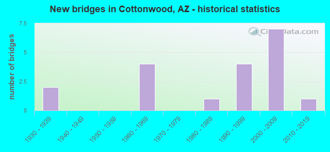
- New bridges - historical statistics
- 21930-1939
- 41960-1969
- 11980-1989
- 41990-1999
- 72000-2009
- 12010-2019

- Reconstructed bridges - Historical Statistics
- 11970-1979
- 21980-1989
- 11990-1999
- 12000-2009


- Bridge Condition - Substructure
- 66.7%Very good
- 33.3%Good

- Bridge Condition - Channel
- 57.9%Good
- 21.1%Satisfactory
- 15.8%Fair
- 5.3%Poor

- Bridge Condition - Culverts
- 87.5%Good
- 12.5%Satisfactory
Find on map >> Show street view
Structure Number: N549, Location: 15 MI W HWY 191 (Lat: 36.068556, Lng: -109.877861), Route carried "on" structure: Federal lands road N4, Year Built: 2003, Status: Open, Structure Length: 1.48m (4.86ft), Average Daily Traffic: 4,035 (year 2012), Truck Traffic: 10%, Average Future Daily Traffic: 4,721 (year 2032), Design Load: HS 20, Features Intersected: WASH
Minimum Vertical Clearance: 30+ m (98+ ft), Kilometerpoint: 23.360, Lanes on structure: 2, Owner: Bureau of Indian Affairs, Approaching Roadway Width: 12.0m (39.4ft), Material/Design: Steel, Design/Construction: Culvert, Number Of Spans In Main Unit: 3, Length of Maximum Span: 3.0m (9.8ft), Curb-To-Curb Width: 12.0m (39.4ft), Out-to-Out Width: 30.1m (98.8ft)
Condition: Channel: Poor, Culverts: Good, Operating Rating: 44.3 metric tons, Method Used To Determine Operating Rating: Allowable Stress (AS), Inventory Rating: 32.4 metric tons, Method Used To Determine Inventory Rating: Allowable Stress (AS), Structural Evaluation: Better than present minimum criteria, Deck Geometry: Somewhat better than minimum adequacy, Waterway Adequacy: Equal to present minimum criteria, Approach Roadway Alignment: Equal to present desirable criteria, Designated Inspection Frequency: Every 24 months, Inspection Date: March 2020
Find on map >> Show street view
Structure Number: N35780B0551, Location: 15 MILES WEST HWY 191 (Lat: 36.073556, Lng: -109.887222), Route carried "on" structure: Federal lands road N4, Year Built: 2010, Status: Open, Structure Length: 0.80m (2.62ft), Average Daily Traffic: 4,035 (year 2020), Truck Traffic: 10%, Average Future Daily Traffic: 4,721 (year 2040), Features Intersected: COTTONWOOD WASH
Minimum Vertical Clearance: 30+ m (98+ ft), Kilometerpoint: 66.780, Lanes on structure: 2, Owner: Bureau of Indian Affairs, Approaching Roadway Width: 11.5m (37.7ft), Skew: 1 degrees, Material/Design: Steel, Design/Construction: Culvert, Number Of Spans In Main Unit: 2, Length of Maximum Span: 3.6m (11.8ft), Curb-To-Curb Width: 11.5m (37.7ft), Out-to-Out Width: 35.0m (114.8ft)
Condition: Channel: Fair, Culverts: Good, Operating Rating: 90.6 metric tons, Method Used To Determine Operating Rating: Load and Resistance Factor (LRFR), Inventory Rating: 90.6 metric tons, Method Used To Determine Inventory Rating: Load and Resistance Factor (LRFR), Structural Evaluation: Better than present minimum criteria, Deck Geometry: Somewhat better than minimum adequacy, Waterway Adequacy: Superior to present desirable criteria, Approach Roadway Alignment: Equal to present desirable criteria, Designated Inspection Frequency: Every 24 months, Inspection Date: March 2020
Find on map >> Show street view
Structure Number: 2369, Location: @ Dead Horse Ranch St Prk (Lat: 34.749600, Lng: -112.022000), Route carried "on" structure: State lands road , Year Built: 1994, Status: Open, Structure Length: 16.76m (54.99ft), Average Daily Traffic: 500 (year 2020), Truck Traffic: 5%, Average Future Daily Traffic: 510 (year 2040), Design Load: HS 20, Features Intersected: Verde River, Facility Carried by Structure: Park Access Rd
Minimum Vertical Clearance: 30+ m (98+ ft), Kilometerpoint: 0.000, Lanes on structure: 2, Owner: State Park, Forest, or Reservation Agency, Approaching Roadway Width: 10.4m (34.1ft), Material/Design: Prestressed concrete continuous, Design/Construction: Stringer/Multi-beam, Number Of Spans In Main Unit: 4, Length of Maximum Span: 41.8m (137.1ft), Curb or Sidewalk Widths: Left: 0.0m, Right: 1.5m (4.9ft), Curb-To-Curb Width: 10.4m (34.1ft), Out-to-Out Width: 13.0m (42.7ft)
Condition: Deck: Good, Superstructure: Very good, Substructure: Very good, Channel: Good, Operating Rating: 89.8 metric tons, Method Used To Determine Operating Rating: Load Factor (LF), Inventory Rating: 49.9 metric tons, Method Used To Determine Inventory Rating: Load Factor (LF), Structural Evaluation: Equal to present desirable criteria, Deck Geometry: Equal to present minimum criteria, Waterway Adequacy: Equal to present desirable criteria, Approach Roadway Alignment: Equal to present desirable criteria, Designated Inspection Frequency: Every 24 months, Inspection Date: August 2020, Deck Structure Type: Concrete Cast-file-Place, Wearing Surface/Protective System: Wearing Surface: Monolithic Concrete
Find on map >> Show street view
Structure Number: 2568, Location: 8.8 mi NW Jct I-17 (Lat: 34.686111, Lng: -111.977778), Route carried "on" structure: State highway 260, Year Built: 2009, Status: Open, Structure Length: 11.06m (36.29ft), Average Daily Traffic: 5,637 (year 2018), Truck Traffic: 8%, Average Future Daily Traffic: 5,647 (year 2040), Design Load: HS 20, Features Intersected: Black Canyon Wash
Minimum Vertical Clearance: 30+ m (98+ ft), Kilometerpoint: 337.769, Lanes on structure: 2, Owner: State Highway Agency, Approaching Roadway Width: 11.6m (38.1ft), Material/Design: Prestressed concrete continuous, Design/Construction: Stringer/Multi-beam, Number Of Spans In Main Unit: 3, Length of Maximum Span: 36.6m (120.1ft), Curb-To-Curb Width: 12.8m (42.0ft), Out-to-Out Width: 13.7m (44.9ft)
Condition: Deck: Good, Superstructure: Very good, Substructure: Good, Channel: Good, Operating Rating: 86.2 metric tons, Method Used To Determine Operating Rating: Load Factor (LF), Inventory Rating: 45.4 metric tons, Method Used To Determine Inventory Rating: Load Factor (LF), Structural Evaluation: Better than present minimum criteria, Deck Geometry: Equal to present desirable criteria, Waterway Adequacy: Equal to present desirable criteria, Approach Roadway Alignment: Equal to present desirable criteria, Designated Inspection Frequency: Every 24 months, Inspection Date: August 2020, Deck Structure Type: Concrete Cast-file-Place, Wearing Surface/Protective System: Wearing Surface: Monolithic Concrete
Find on map >> Show street view
Structure Number: 257, Location: 8.1 mi NW Jct I-17 (Lat: 34.675000, Lng: -111.969444), Route carried "on" structure: State highway 260, Year Built: 2009, Status: Open, Structure Length: 18.38m (60.30ft), Average Daily Traffic: 5,637 (year 2018), Truck Traffic: 8%, Average Future Daily Traffic: 5,647 (year 2040), Design Load: HS 20, Features Intersected: Wilbur Canyon
Minimum Vertical Clearance: 30+ m (98+ ft), Kilometerpoint: 338.847, Lanes on structure: 2, Owner: State Highway Agency, Approaching Roadway Width: 11.6m (38.1ft), Material/Design: Prestressed concrete continuous, Design/Construction: Stringer/Multi-beam, Number Of Spans In Main Unit: 5, Length of Maximum Span: 36.6m (120.1ft), Curb-To-Curb Width: 12.8m (42.0ft), Out-to-Out Width: 13.7m (44.9ft)
Condition: Deck: Good, Superstructure: Very good, Substructure: Very good, Channel: Good, Operating Rating: 84.4 metric tons, Method Used To Determine Operating Rating: Load Factor (LF), Inventory Rating: 45.4 metric tons, Method Used To Determine Inventory Rating: Load Factor (LF), Structural Evaluation: Equal to present desirable criteria, Deck Geometry: Equal to present desirable criteria, Waterway Adequacy: Equal to present desirable criteria, Approach Roadway Alignment: Equal to present desirable criteria, Designated Inspection Frequency: Every 24 months, Inspection Date: August 2020, Deck Structure Type: Concrete Cast-file-Place, Wearing Surface/Protective System: Wearing Surface: Monolithic Concrete
Find on map >> Show street view
Structure Number: 5123, Location: 0.05 mi S Jct SR 89A (Lat: 34.714600, Lng: -111.999300), Route carried "on" structure: State highway 260, Year Built: 1962, Year Reconstructed: 1997, Status: Open, Structure Length: 0.98m (3.22ft), Average Daily Traffic: 26,538 (year 2017), Truck Traffic: 6%, Average Future Daily Traffic: 26,548 (year 2037), Design Load: HS 20, Features Intersected: Oak Wash
Minimum Vertical Clearance: 30+ m (98+ ft), Kilometerpoint: 332.474, Lanes on structure: 4, Owner: State Highway Agency, Approaching Roadway Width: 19.8m (65.0ft), Material/Design: Concrete continuous, Design/Construction: Culvert, Number Of Spans In Main Unit: 3, Length of Maximum Span: 3.0m (9.8ft), Curb or Sidewalk Widths: Left: 1.7m (5.6ft), Right: 1.7m (5.6ft)
Condition: Channel: Good, Culverts: Good, Operating Rating: 58.1 metric tons, Method Used To Determine Operating Rating: Load Factor (LF), Inventory Rating: 34.5 metric tons, Method Used To Determine Inventory Rating: Load Factor (LF), Structural Evaluation: Better than present minimum criteria, Waterway Adequacy: Equal to present desirable criteria, Approach Roadway Alignment: Equal to present minimum criteria, Length Of Structure Improvement: 1.74m (5.71ft), Designated Inspection Frequency: Every 48 months, Inspection Date: July 2018, Total Project Cost: $1,000 ( Estimate for 2014)
Find on map >> Show street view
Structure Number: 6183, Location: 1.2 mi NW Jct SR 260 (Lat: 34.728700, Lng: -112.020100), Route carried "on" structure: Alternate State highway 89, Year Built: 1964, Year Reconstructed: 1989, Status: Open, Structure Length: 1.65m (5.41ft), Average Daily Traffic: 27,074 (year 2018), Truck Traffic: 11%, Average Future Daily Traffic: 27,084 (year 2040), Design Load: HS 20, Features Intersected: Silver Springs
Minimum Vertical Clearance: 30+ m (98+ ft), Kilometerpoint: 567.262, Lanes on structure: 4, Owner: State Highway Agency, Approaching Roadway Width: 21.0m (68.9ft), Material/Design: Concrete continuous, Design/Construction: Culvert, Number Of Spans In Main Unit: 5, Length of Maximum Span: 3.0m (9.8ft), Curb or Sidewalk Widths: Left: 2.0m (6.6ft), Right: 2.0m (6.6ft)
Condition: Channel: Good, Culverts: Good, Operating Rating: 89.8 metric tons, Method Used To Determine Operating Rating: Load Factor (LF), Inventory Rating: 89.8 metric tons, Method Used To Determine Inventory Rating: Load Factor (LF), Structural Evaluation: Better than present minimum criteria, Waterway Adequacy: Equal to present minimum criteria, Approach Roadway Alignment: Equal to present desirable criteria, Length Of Structure Improvement: 2.38m (7.81ft), Designated Inspection Frequency: Every 48 months, Inspection Date: July 2020, Total Project Cost: $2,000 ( Estimate for 2020)
Find on map >> Show street view
Structure Number: 6184, Location: 2.5 mi NW Jct SR 260 (Lat: 34.739700, Lng: -112.037200), Route carried "on" structure: Alternate State highway 89, Year Built: 1964, Year Reconstructed: 1989, Status: Open, Structure Length: 1.37m (4.49ft), Average Daily Traffic: 11,288 (year 2018), Truck Traffic: 13%, Average Future Daily Traffic: 11,298 (year 2040), Design Load: HS 20, Features Intersected: Del Monte Wash
Minimum Vertical Clearance: 30+ m (98+ ft), Kilometerpoint: 565.234, Lanes on structure: 4, Owner: State Highway Agency, Approaching Roadway Width: 21.0m (68.9ft), Skew: 24 degrees, Material/Design: Concrete continuous, Design/Construction: Culvert, Number Of Spans In Main Unit: 3, Length of Maximum Span: 3.0m (9.8ft), Curb or Sidewalk Widths: Left: 2.0m (6.6ft), Right: 2.0m (6.6ft)
Condition: Channel: Good, Culverts: Good, Operating Rating: 89.8 metric tons, Method Used To Determine Operating Rating: Load Factor (LF), Inventory Rating: 89.8 metric tons, Method Used To Determine Inventory Rating: Load Factor (LF), Structural Evaluation: Better than present minimum criteria, Waterway Adequacy: Equal to present desirable criteria, Approach Roadway Alignment: Equal to present desirable criteria, Length Of Structure Improvement: 2.13m (6.99ft), Designated Inspection Frequency: Every 48 months, Inspection Date: July 2020, Bridge Improvement Cost: $1,000, Total Project Cost: $2,000 ( Estimate for 2020)
Find on map >> Show street view
Structure Number: 6185, Location: 3.3 mi NW Jct SR 260 (Lat: 34.744200, Lng: -112.041800), Route carried "on" structure: Alternate State highway 89, Year Built: 1964, Year Reconstructed: 2008, Status: Open, Structure Length: 1.55m (5.09ft), Average Daily Traffic: 10,515 (year 2018), Truck Traffic: 10%, Average Future Daily Traffic: 10,525 (year 2040), Design Load: HS 20, Features Intersected: Mescal Gulch
Minimum Vertical Clearance: 30+ m (98+ ft), Kilometerpoint: 563.914, Lanes on structure: 4, Owner: State Highway Agency, Approaching Roadway Width: 17.7m (58.1ft), Skew: 20 degrees, Material/Design: Concrete continuous, Design/Construction: Culvert, Number Of Spans In Main Unit: 4, Length of Maximum Span: 3.7m (12.1ft), Curb or Sidewalk Widths: Left: 2.0m (6.6ft), Right: 2.0m (6.6ft)
Condition: Channel: Good, Culverts: Good, Operating Rating: 89.8 metric tons, Method Used To Determine Operating Rating: Load Factor (LF), Inventory Rating: 89.8 metric tons, Method Used To Determine Inventory Rating: Load Factor (LF), Structural Evaluation: Better than present minimum criteria, Waterway Adequacy: Equal to present minimum criteria, Approach Roadway Alignment: Equal to present desirable criteria, Length Of Structure Improvement: 2.32m (7.61ft), Designated Inspection Frequency: Every 48 months, Inspection Date: July 2020, Total Project Cost: $2,000 ( Estimate for 2020)
Find on map >> Show street view
Structure Number: 7014, Location: 0.5 mi E Jct 10th St (Lat: 34.755100, Lng: -112.015300), Route carried "on" structure: State lands road , Year Built: 1994, Status: Open, Structure Length: 0.73m (2.40ft), Average Daily Traffic: 200 (year 2020), Truck Traffic: 1%, Average Future Daily Traffic: 210 (year 2040), Design Load: HS 20, Features Intersected: Wash, Facility Carried by Structure: Main Park Rd
Minimum Vertical Clearance: 30+ m (98+ ft), Kilometerpoint: 0.000, Lanes on structure: 2, Owner: State Park, Forest, or Reservation Agency, Approaching Roadway Width: 8.5m (27.9ft), Skew: 3 degrees, Material/Design: Concrete continuous, Design/Construction: Culvert, Number Of Spans In Main Unit: 2, Length of Maximum Span: 3.0m (9.8ft), Curb or Sidewalk Widths: Left: 1.4m (4.6ft), Right: 1.4m (4.6ft)
Condition: Channel: Fair, Culverts: Good, Operating Rating: 89.8 metric tons, Method Used To Determine Operating Rating: Load Factor (LF), Inventory Rating: 89.8 metric tons, Method Used To Determine Inventory Rating: Load Factor (LF), Structural Evaluation: Better than present minimum criteria, Waterway Adequacy: Equal to present desirable criteria, Approach Roadway Alignment: Equal to present desirable criteria, Designated Inspection Frequency: Every 48 months, Inspection Date: August 2020
Find on map >> Show street view
Structure Number: 7081, Location: 2.9 mi N Jct SR 260 (Lat: 34.744800, Lng: -111.967800), Route carried "on" structure: Alternate State highway 89, Year Built: 2005, Status: Open, Structure Length: 0.88m (2.89ft), Average Daily Traffic: 14,845 (year 2019), Truck Traffic: 7%, Average Future Daily Traffic: 14,855 (year 2039), Design Load: HS 20, Features Intersected: Zalesky Wash
Minimum Vertical Clearance: 30+ m (98+ ft), Kilometerpoint: 576.590, Lanes on structure: 6, Owner: State Highway Agency, Approaching Roadway Width: 23.2m (76.1ft), Skew: 32 degrees, Material/Design: Concrete continuous, Design/Construction: Culvert, Number Of Spans In Main Unit: 3, Length of Maximum Span: 2.4m (7.9ft)
Condition: Channel: Satisfactory, Culverts: Good, Operating Rating: 89.8 metric tons, Method Used To Determine Operating Rating: Load Factor (LF), Inventory Rating: 89.8 metric tons, Method Used To Determine Inventory Rating: Load Factor (LF), Structural Evaluation: Better than present minimum criteria, Waterway Adequacy: Better than present minimum criteria, Approach Roadway Alignment: Equal to present desirable criteria, Designated Inspection Frequency: Every 48 months, Inspection Date: August 2021
Find on map >> Show street view
Structure Number: 9624, Location: 0.9 mi NE Jct SR 89A (Lat: 34.745500, Lng: -112.026300), Route carried "on" structure: City street , Year Built: 1935, Status: Open, Structure Length: 1.10m (3.61ft), Average Daily Traffic: 7,400 (year 2018), Truck Traffic: 5%, Average Future Daily Traffic: 7,410 (year 2038), Features Intersected: Del Monte Wash, Facility Carried by Structure: Main Street
Minimum Vertical Clearance: 6.10m (20.01ft), Kilometerpoint: 0.000, Lanes on structure: 2, Owner: City or Municipal Highway Agency, Approaching Roadway Width: 12.2m (40.0ft), Skew: 3 degrees, Material/Design: Concrete continuous, Design/Construction: Culvert, Number Of Spans In Main Unit: 3, Length of Maximum Span: 3.0m (9.8ft), Curb or Sidewalk Widths: Left: 1.4m (4.6ft), Right: 1.4m (4.6ft), Curb-To-Curb Width: 12.2m (40.0ft), Out-to-Out Width: 13.0m (42.7ft)
Condition: Channel: Satisfactory, Culverts: Satisfactory, Operating Rating: 52.6 metric tons, Method Used To Determine Operating Rating: Load Factor (LF), Inventory Rating: 31.8 metric tons, Method Used To Determine Inventory Rating: Load Factor (LF), Structural Evaluation: Equal to present minimum criteria, Deck Geometry: Somewhat better than minimum adequacy, Waterway Adequacy: Better than present minimum criteria, Approach Roadway Alignment: Equal to present desirable criteria, Designated Inspection Frequency: Every 48 months, Inspection Date: September 2018, Deck Structure Type: Concrete Cast-file-Place, Wearing Surface/Protective System: Wearing Surface: Bituminous
Find on map >> Show street view
Structure Number: 9625, Location: 600 ft N Jct SR 89A (Lat: 34.730300, Lng: -112.009700), Route carried "on" structure: City street , Year Built: 1935, Year Reconstructed: 1975, Status: Open, Structure Length: 1.31m (4.30ft), Average Daily Traffic: 16,850 (year 2018), Truck Traffic: 2%, Average Future Daily Traffic: 16,860 (year 2038), Design Load: HS 20, Features Intersected: Silver Spring Gulch, Facility Carried by Structure: Main Street
Minimum Vertical Clearance: 6.10m (20.01ft), Kilometerpoint: 0.000, Lanes on structure: 4, Owner: City or Municipal Highway Agency, Approaching Roadway Width: 20.7m (67.9ft), Material/Design: Concrete continuous, Design/Construction: Culvert, Number Of Spans In Main Unit: 4, Length of Maximum Span: 3.0m (9.8ft)
Condition: Channel: Fair, Culverts: Satisfactory, Operating Rating: 89.8 metric tons, Method Used To Determine Operating Rating: Load Factor (LF), Inventory Rating: 89.8 metric tons, Method Used To Determine Inventory Rating: Load Factor (LF), Structural Evaluation: Equal to present minimum criteria, Waterway Adequacy: Better than present minimum criteria, Approach Roadway Alignment: Equal to present desirable criteria, Designated Inspection Frequency: Every 48 months, Inspection Date: September 2018
Find on map >> Show street view
Structure Number: 9962, Location: 0.3 mi E of Jct A 89 (Lat: 34.731278, Lng: -111.973139), Route carried "on" structure: County highway , Year Built: 1988, Status: Open, Structure Length: 0.70m (2.30ft), Average Daily Traffic: 14,949 (year 2019), Truck Traffic: 5%, Average Future Daily Traffic: 14,959 (year 2039), Design Load: HS 20, Features Intersected: No Name Wash, Facility Carried by Structure: Cornville Road
Minimum Vertical Clearance: 30+ m (98+ ft), Kilometerpoint: 0.000, Lanes on structure: 2, Owner: County Highway Agency, Approaching Roadway Width: 8.5m (27.9ft), Material/Design: Steel, Design/Construction: Culvert, Number Of Spans In Main Unit: 1, Length of Maximum Span: 7.0m (23.0ft)
Condition: Channel: Satisfactory, Culverts: Good, Operating Rating: 89.8 metric tons, Method Used To Determine Operating Rating: Load Factor (LF), Inventory Rating: 89.8 metric tons, Method Used To Determine Inventory Rating: Load Factor (LF), Structural Evaluation: Better than present minimum criteria, Waterway Adequacy: Equal to present desirable criteria, Approach Roadway Alignment: Equal to present desirable criteria, Designated Inspection Frequency: Every 48 months, Inspection Date: September 2019
Find on map >> Show street view
Structure Number: 9998, Location: 0.6 mi E Jct A 89 (Lat: 34.729611, Lng: -111.968139), Route carried "on" structure: County highway , Year Built: 1993, Status: Open, Structure Length: 1.55m (5.09ft), Average Daily Traffic: 14,949 (year 2019), Truck Traffic: 5%, Average Future Daily Traffic: 14,959 (year 2039), Design Load: HS 20, Features Intersected: Desert Drainage, Facility Carried by Structure: Cornville Road
Minimum Vertical Clearance: 30+ m (98+ ft), Kilometerpoint: 0.000, Lanes on structure: 2, Owner: County Highway Agency, Approaching Roadway Width: 12.2m (40.0ft), Material/Design: Steel, Design/Construction: Culvert, Number Of Spans In Main Unit: 6, Length of Maximum Span: 1.8m (5.9ft)
Condition: Channel: Good, Culverts: Good, Operating Rating: 64.4 metric tons, Method Used To Determine Operating Rating: Load Factor (LF), Inventory Rating: 37.2 metric tons, Method Used To Determine Inventory Rating: Load Factor (LF), Structural Evaluation: Better than present minimum criteria, Waterway Adequacy: Equal to present desirable criteria, Approach Roadway Alignment: Equal to present desirable criteria, Designated Inspection Frequency: Every 48 months, Inspection Date: September 2019
Find on map >> Show street view
Structure Number: 10733, Location: 0.5 mi S of Cornville Rd (Lat: 34.719639, Lng: -111.958111), Route carried "on" structure: County highway , Year Built: 2004, Status: Open, Structure Length: 1.07m (3.51ft), Average Daily Traffic: 2,224 (year 2019), Truck Traffic: 1%, Average Future Daily Traffic: 2,234 (year 2039), Design Load: HS 20, Features Intersected: Wash, Facility Carried by Structure: Tissaw Rd
Minimum Vertical Clearance: 30+ m (98+ ft), Kilometerpoint: 0.000, Lanes on structure: 2, Owner: County Highway Agency, Approaching Roadway Width: 9.1m (29.9ft), Skew: 1 degrees, Material/Design: Steel, Design/Construction: Culvert, Number Of Spans In Main Unit: 4, Length of Maximum Span: 1.8m (5.9ft)
Condition: Channel: Good, Culverts: Good, Operating Rating: 64.4 metric tons, Method Used To Determine Operating Rating: Load Factor (LF), Inventory Rating: 37.2 metric tons, Method Used To Determine Inventory Rating: Load Factor (LF), Structural Evaluation: Better than present minimum criteria, Waterway Adequacy: Better than present minimum criteria, Approach Roadway Alignment: Equal to present desirable criteria, Designated Inspection Frequency: Every 48 months, Inspection Date: September 2019
Find on map >> Show street view
Structure Number: 10739, Location: 0.2 mi E of Tissaw Rd (Lat: 34.720000, Lng: -111.957400), Route carried "on" structure: County highway , Year Built: 2004, Status: Open, Structure Length: 0.70m (2.30ft), Average Daily Traffic: 150 (year 2019), Truck Traffic: 1%, Average Future Daily Traffic: 160 (year 2039), Design Load: HS 20, Features Intersected: Wash, Facility Carried by Structure: Forest Ridge Dr
Minimum Vertical Clearance: 30+ m (98+ ft), Kilometerpoint: 0.000, Lanes on structure: 2, Owner: County Highway Agency, Approaching Roadway Width: 7.6m (24.9ft), Skew: 2 degrees, Material/Design: Steel, Design/Construction: Culvert, Number Of Spans In Main Unit: 4, Length of Maximum Span: 1.2m (3.9ft)
Condition: Channel: Good, Culverts: Good, Operating Rating: 89.8 metric tons, Method Used To Determine Operating Rating: Load Factor (LF), Inventory Rating: 89.8 metric tons, Method Used To Determine Inventory Rating: Load Factor (LF), Structural Evaluation: Better than present minimum criteria, Waterway Adequacy: Better than present minimum criteria, Approach Roadway Alignment: Equal to present desirable criteria, Designated Inspection Frequency: Every 48 months, Inspection Date: September 2019
Find on map >> Show street view
Structure Number: 10834, Location: 430 ft N Jct SR 89A (Lat: 34.729800, Lng: -112.014100), Route carried "on" structure: City street , Year Built: 1994, Status: Open, Structure Length: 2.04m (6.69ft), Average Daily Traffic: 4,700 (year 2018), Truck Traffic: 2%, Average Future Daily Traffic: 4,710 (year 2038), Design Load: HS 20, Features Intersected: Silver Spring Gulch, Facility Carried by Structure: 12th Street
Minimum Vertical Clearance: 30+ m (98+ ft), Kilometerpoint: 0.000, Lanes on structure: 2, Owner: City or Municipal Highway Agency, Approaching Roadway Width: 10.4m (34.1ft), Skew: 1 degrees, Material/Design: Concrete continuous, Design/Construction: Culvert, Number Of Spans In Main Unit: 6, Length of Maximum Span: 3.0m (9.8ft)
Condition: Channel: Satisfactory, Culverts: Good, Operating Rating: 89.8 metric tons, Method Used To Determine Operating Rating: Load Factor (LF), Inventory Rating: 89.8 metric tons, Method Used To Determine Inventory Rating: Load Factor (LF), Structural Evaluation: Better than present minimum criteria, Waterway Adequacy: Equal to present desirable criteria, Approach Roadway Alignment: Equal to present desirable criteria, Designated Inspection Frequency: Every 48 months, Inspection Date: September 2018
Find on map >> Show street view
Structure Number: 11073, Location: 0.7 mi S Jct SR 89A (Lat: 34.723800, Lng: -112.029300), Route carried "on" structure: City street , Year Built: 2009, Status: Open, Structure Length: 2.07m (6.79ft), Average Daily Traffic: 500 (year 2018), Truck Traffic: 2%, Average Future Daily Traffic: 510 (year 2038), Design Load: HS 20, Features Intersected: Silver Spring Gulch, Facility Carried by Structure: Willard St
Minimum Vertical Clearance: 30+ m (98+ ft), Kilometerpoint: 0.000, Lanes on structure: 2, Owner: City or Municipal Highway Agency, Approaching Roadway Width: 10.1m (33.1ft), Skew: 2 degrees, Material/Design: Concrete continuous, Design/Construction: Culvert, Number Of Spans In Main Unit: 6, Length of Maximum Span: 3.0m (9.8ft)
Condition: Channel: Good, Culverts: Good, Operating Rating: 89.8 metric tons, Method Used To Determine Operating Rating: Load Factor (LF), Inventory Rating: 71.7 metric tons, Method Used To Determine Inventory Rating: Load Factor (LF), Structural Evaluation: Better than present minimum criteria, Waterway Adequacy: Equal to present desirable criteria, Approach Roadway Alignment: Equal to present desirable criteria, Designated Inspection Frequency: Every 48 months, Inspection Date: September 2018