Bridge Statistics for Corry, Pennsylvania (PA)
Condition, Traffic, Stress, Structural Evaluation, Project Costs
- National Bridge Inventory (NBI) Statistics
- 20Number of bridges
- 89ft / 27.1mTotal length
- $841,000Total costs
- 32,802Total average daily traffic
- 2,367Total average daily truck traffic
- 50,795Total future (year 2032) average daily traffic
- National Bridge Inventory (NBI) Registered Bridges for Corry
- No street view available for this location
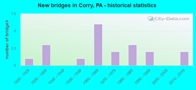
- New bridges - historical statistics
- 11920-1929
- 31930-1939
- 11950-1959
- 61960-1969
- 21970-1979
- 31980-1989
- 21990-1999
- 22010-2019

- Reconstructed bridges - Historical Statistics
- 21980-1989
- 11990-1999
- 22000-2009


- Bridge Condition - Deck
- 6.7%Excellent
- 13.3%Very good
- 26.7%Good
- 26.7%Satisfactory
- 26.7%Fair

- Bridge Condition - Superstructure
- 13.3%Very good
- 33.3%Good
- 13.3%Satisfactory
- 33.3%Fair
- 6.7%Poor

- Bridge Condition - Substructure
- 6.7%Excellent
- 20.0%Very good
- 13.3%Good
- 33.3%Satisfactory
- 26.7%Fair

- Bridge Condition - Channel
- 5.0%Very good
- 20.0%Good
- 20.0%Satisfactory
- 45.0%Fair
- 10.0%Poor

- Bridge Condition - Culverts
- 20.0%Good
- 40.0%Satisfactory
- 20.0%Poor
- 20.0%Serious
Find on map >> Show street view
Structure Number: 15841, Location: WAYNE TOWNSHIP (Lat: 41.928292, Lng: -79.678581), Route carried "on" structure: US 6, Year Built: 1991, Status: Open, Structure Length: 0.98m (3.22ft), Average Daily Traffic: 6,639 (year 2022), Truck Traffic: 10%, Average Future Daily Traffic: 7,778 (year 2032), Design Load: HS 25 or greater, Features Intersected: OVER SPENCER CREEK
Minimum Vertical Clearance: 30+ m (98+ ft), Kilometerpoint: 34.092, Lanes on structure: 2, Base Highway Network: Yes, Owner: State Highway Agency, Approaching Roadway Width: 9.8m (32.2ft), Material/Design: Concrete, Design/Construction: Culvert, Number Of Spans In Main Unit: 2, Length of Maximum Span: 4.6m (15.1ft), Curb-To-Curb Width: 13.6m (44.6ft), Out-to-Out Width: 16.5m (54.1ft)
Condition: Channel: Fair, Culverts: Satisfactory, Inventory Rating: 75.3 metric tons, Method Used To Determine Inventory Rating: Load Factor (LF), Structural Evaluation: Equal to present minimum criteria, Deck Geometry: Superior to present desirable criteria, Waterway Adequacy: Equal to present minimum criteria, Approach Roadway Alignment: Equal to present desirable criteria, Length Of Structure Improvement: 1.00m (3.28ft), Designated Inspection Frequency: Every 48 months, Inspection Date: April 2019
Find on map >> Show street view
Structure Number: 15843, Location: CITY OF CORRY (Lat: 41.936194, Lng: -79.632694), Route carried "on" structure: US 6, Year Built: 1930, Status: Open, Structure Length: 1.46m (4.79ft), Average Daily Traffic: 7,703 (year 2021), Truck Traffic: 9%, Average Future Daily Traffic: 10,189 (year 2032), Design Load: HS 15, Features Intersected: OVER HARE CREEK
Minimum Vertical Clearance: 30+ m (98+ ft), Kilometerpoint: 38.071, Lanes on structure: 2, Base Highway Network: Yes, Owner: State Highway Agency, Approaching Roadway Width: 10.4m (34.1ft), Skew: 3 degrees, Material/Design: Concrete, Design/Construction: Tee Beam, Number Of Spans In Main Unit: 1, Length of Maximum Span: 14.0m (45.9ft), Curb-To-Curb Width: 10.7m (35.1ft), Out-to-Out Width: 13.1m (43.0ft)
Condition: Deck: Satisfactory, Superstructure: Fair, Substructure: Fair, Channel: Fair, Operating Rating: 59.0 metric tons, Method Used To Determine Operating Rating: Load Factor (LF), Inventory Rating: 35.4 metric tons, Method Used To Determine Inventory Rating: Load Factor (LF), Structural Evaluation: Somewhat better than minimum adequacy, Deck Geometry: Meets minimum limits, Waterway Adequacy: Superior to present desirable criteria, Approach Roadway Alignment: Equal to present desirable criteria, Length Of Structure Improvement: 2.10m (6.89ft), Designated Inspection Frequency: Every 24 months, Inspection Date: September 2020, Bridge Improvement Cost: $12,000, Roadway Improvement Cost: $35,000, Total Project Cost: $160,000, Deck Structure Type: Concrete Cast-file-Place, Wearing Surface/Protective System: Wearing Surface: Bituminous, Membrane: Preformed Fabric
Find on map >> Show street view
Structure Number: 16251, Location: CONCORD TOWNSHIP (Lat: 41.896978, Lng: -79.665289), Route carried "on" structure: State highway , Year Built: 1982, Status: Open, Structure Length: 0.61m (2.00ft), Average Daily Traffic: 250 (year 2020), Truck Traffic: 8%, Average Future Daily Traffic: 542 (year 2032), Design Load: HS 20, Features Intersected: OVER FRENCH CREEK S BR, Facility Carried by Structure: SR 2014,STEWART RD
Minimum Vertical Clearance: 30+ m (98+ ft), Kilometerpoint: 4.471, Lanes on structure: 2, Owner: State Highway Agency, Approaching Roadway Width: 8.5m (27.9ft), Material/Design: Concrete, Design/Construction: Culvert, Number Of Spans In Main Unit: 1, Length of Maximum Span: 6.1m (20.0ft), Curb-To-Curb Width: 8.5m (27.9ft), Out-to-Out Width: 9.6m (31.5ft)
Condition: Channel: Fair, Culverts: Good, Operating Rating: 40.8 metric tons, Method Used To Determine Operating Rating: Load Factor (LF), Inventory Rating: 24.5 metric tons, Method Used To Determine Inventory Rating: Load Factor (LF), Structural Evaluation: Equal to present minimum criteria, Deck Geometry: Equal to present minimum criteria, Waterway Adequacy: Equal to present desirable criteria, Approach Roadway Alignment: Equal to present desirable criteria, Length Of Structure Improvement: 1.20m (3.94ft), Designated Inspection Frequency: Every 24 months, Inspection Date: November 2021, Wearing Surface/Protective System: Wearing Surface: Monolithic Concrete
Find on map >> Show street view
Structure Number: 1626, Location: CONCORD TOWNSHIP (Lat: 41.916403, Lng: -79.659853), Route carried "on" structure: State highway , Year Built: 1966, Status: Open, Structure Length: 0.76m (2.49ft), Average Daily Traffic: 719 (year 2020), Truck Traffic: 2%, Average Future Daily Traffic: 1,033 (year 2032), Design Load: H 20, Features Intersected: OVER FRENCH CREEK S BR, Facility Carried by Structure: SR 2018,ELGIN RD
Minimum Vertical Clearance: 30+ m (98+ ft), Kilometerpoint: 12.233, Lanes on structure: 2, Owner: State Highway Agency, Approaching Roadway Width: 6.7m (22.0ft), Material/Design: Steel, Design/Construction: Culvert, Number Of Spans In Main Unit: 1, Length of Maximum Span: 7.6m (24.9ft)
Condition: Channel: Good, Culverts: Poor, Operating Rating: 40.8 metric tons, Method Used To Determine Operating Rating: Field evaluation and documented engineering judgment, Inventory Rating: 32.7 metric tons, Method Used To Determine Inventory Rating: Field evaluation and documented engineering judgment, Structural Evaluation: Meets minimum limits, Waterway Adequacy: Superior to present desirable criteria, Approach Roadway Alignment: Equal to present desirable criteria, Length Of Structure Improvement: 1.50m (4.92ft), Designated Inspection Frequency: Every 24 months, Other Special Inspection Frequency: Every 12 months, Inspection Date: October 2021, Other Special Inspection Date: October 2021
Find on map >> Show street view
Structure Number: 16266, Location: WAYNE TOWNSHIP (Lat: 41.925464, Lng: -79.679797), Route carried "on" structure: State highway , Year Built: 1962, Status: Open, Structure Length: 0.91m (2.99ft), Average Daily Traffic: 1,166 (year 2021), Truck Traffic: 8%, Average Future Daily Traffic: 4,471 (year 2032), Design Load: H 20, Features Intersected: OVER SPENCER CREEK, Facility Carried by Structure: SR 2020,CONNELWAY
Minimum Vertical Clearance: 30+ m (98+ ft), Kilometerpoint: 0.912, Lanes on structure: 2, Owner: State Highway Agency, Approaching Roadway Width: 6.7m (22.0ft), Skew: 1 degrees, Material/Design: Concrete, Design/Construction: Slab, Number Of Spans In Main Unit: 1, Length of Maximum Span: 8.8m (28.9ft), Curb or Sidewalk Widths: Left: 0.5m (1.6ft), Right: 0.5m (1.6ft), Curb-To-Curb Width: 10.1m (33.1ft), Out-to-Out Width: 11.7m (38.4ft)
Condition: Deck: Good, Superstructure: Good, Substructure: Very good, Channel: Poor, Operating Rating: 63.5 metric tons, Method Used To Determine Operating Rating: Load Factor (LF), Inventory Rating: 38.1 metric tons, Method Used To Determine Inventory Rating: Load Factor (LF), Structural Evaluation: Better than present minimum criteria, Deck Geometry: Somewhat better than minimum adequacy, Waterway Adequacy: Better than present minimum criteria, Approach Roadway Alignment: Equal to present desirable criteria, Length Of Structure Improvement: 0.90m (2.95ft), Designated Inspection Frequency: Every 24 months, Inspection Date: July 2020, Wearing Surface/Protective System: Wearing Surface: Bituminous, Membrane: Preformed Fabric
Find on map >> Show street view
Structure Number: 16267, Location: CONCORD TOWNSHIP (Lat: 41.920211, Lng: -79.676167), Route carried "on" structure: State highway , Year Built: 1962, Status: Open, Structure Length: 1.58m (5.18ft), Average Daily Traffic: 1,166 (year 2021), Truck Traffic: 8%, Average Future Daily Traffic: 4,471 (year 2032), Design Load: HS 20, Features Intersected: OVER FRENCH CREEK S BR, Facility Carried by Structure: SR 2020,WSHNGTN.ST
Minimum Vertical Clearance: 30+ m (98+ ft), Kilometerpoint: 1.822, Lanes on structure: 2, Owner: State Highway Agency, Approaching Roadway Width: 7.3m (24.0ft), Skew: 1 degrees, Material/Design: Prestressed concrete, Design/Construction: Box Beam or Girders - Multiple, Number Of Spans In Main Unit: 1, Length of Maximum Span: 15.2m (49.9ft), Curb or Sidewalk Widths: Left: 0.5m (1.6ft), Right: 0.5m (1.6ft), Curb-To-Curb Width: 10.4m (34.1ft), Out-to-Out Width: 11.7m (38.4ft)
Condition: Deck: Satisfactory, Superstructure: Good, Substructure: Very good, Channel: Fair, Operating Rating: 73.5 metric tons, Method Used To Determine Operating Rating: Load Factor (LF), Inventory Rating: 35.4 metric tons, Method Used To Determine Inventory Rating: Load Factor (LF), Structural Evaluation: Better than present minimum criteria, Deck Geometry: Equal to present minimum criteria, Waterway Adequacy: Equal to present desirable criteria, Approach Roadway Alignment: Equal to present minimum criteria, Length Of Structure Improvement: 2.30m (7.55ft), Designated Inspection Frequency: Every 24 months, Underwater Inspection Frequency: Every 60 months, Inspection Date: November 2019, Underwater Inspection Date: April 2018, Deck Structure Type: Concrete Cast-file-Place, Wearing Surface/Protective System: Wearing Surface: Bituminous, Membrane: Preformed Fabric
Find on map >> Show street view
Structure Number: 16268, Location: CONCORD TOWNSHIP (Lat: 41.918547, Lng: -79.663456), Route carried "on" structure: State highway , Year Built: 1962, Year Reconstructed: 2012, Status: Open, Structure Length: 1.10m (3.61ft), Average Daily Traffic: 1,166 (year 2021), Truck Traffic: 8%, Average Future Daily Traffic: 4,471 (year 2032), Design Load: HS 20, Features Intersected: OVER FRENCH CREEK S BR, Facility Carried by Structure: SR 2020,WSHNGTN.ST
Minimum Vertical Clearance: 30+ m (98+ ft), Kilometerpoint: 2.931, Lanes on structure: 2, Owner: State Highway Agency, Approaching Roadway Width: 6.7m (22.0ft), Skew: 3 degrees, Material/Design: Prestressed concrete, Design/Construction: Box Beam or Girders - Multiple, Number Of Spans In Main Unit: 1, Length of Maximum Span: 10.4m (34.1ft), Curb or Sidewalk Widths: Left: 0.5m (1.6ft), Right: 0.5m (1.6ft), Curb-To-Curb Width: 9.1m (29.9ft), Out-to-Out Width: 10.8m (35.4ft)
Condition: Deck: Excellent, Superstructure: Good, Substructure: Satisfactory, Channel: Fair, Operating Rating: 53.5 metric tons, Method Used To Determine Operating Rating: Load Factor (LF), Inventory Rating: 31.8 metric tons, Method Used To Determine Inventory Rating: Load Factor (LF), Structural Evaluation: Equal to present minimum criteria, Deck Geometry: Somewhat better than minimum adequacy, Waterway Adequacy: Better than present minimum criteria, Approach Roadway Alignment: Equal to present desirable criteria, Length Of Structure Improvement: 1.10m (3.61ft), Designated Inspection Frequency: Every 24 months, Underwater Inspection Frequency: Every 60 months, Inspection Date: May 2021, Underwater Inspection Date: October 2017, Bridge Improvement Cost: $9,000, Roadway Improvement Cost: $25,000, Total Project Cost: $117,000, Deck Structure Type: Concrete Cast-file-Place, Wearing Surface/Protective System: Wearing Surface: Bituminous
Find on map >> Show street view
Structure Number: 16272, Location: WAYNE TOWNSHIP (Lat: 41.934536, Lng: -79.683022), Route carried "on" structure: State highway , Year Built: 1963, Status: Open, Structure Length: 0.73m (2.40ft), Average Daily Traffic: 271 (year 2022), Truck Traffic: 5%, Average Future Daily Traffic: 389 (year 2032), Design Load: HS 20, Features Intersected: OVER SPENCER RUN, Facility Carried by Structure: SR 2022,TURNPIKE R
Minimum Vertical Clearance: 30+ m (98+ ft), Kilometerpoint: 5.621, Lanes on structure: 2, Owner: State Highway Agency, Approaching Roadway Width: 5.2m (17.1ft), Material/Design: Concrete, Design/Construction: Slab, Number Of Spans In Main Unit: 1, Length of Maximum Span: 6.7m (22.0ft), Curb or Sidewalk Widths: Left: 0.5m (1.6ft), Right: 0.5m (1.6ft), Curb-To-Curb Width: 9.3m (30.5ft), Out-to-Out Width: 10.8m (35.4ft)
Condition: Deck: Fair, Superstructure: Fair, Substructure: Good, Channel: Good, Operating Rating: 47.2 metric tons, Method Used To Determine Operating Rating: Load Factor (LF), Inventory Rating: 28.1 metric tons, Method Used To Determine Inventory Rating: Load Factor (LF), Structural Evaluation: Somewhat better than minimum adequacy, Deck Geometry: Equal to present minimum criteria, Waterway Adequacy: Better than present minimum criteria, Approach Roadway Alignment: Equal to present desirable criteria, Length Of Structure Improvement: 0.70m (2.30ft), Designated Inspection Frequency: Every 24 months, Inspection Date: April 2021, Bridge Improvement Cost: $3,000, Roadway Improvement Cost: $25,000, Total Project Cost: $42,000, Wearing Surface/Protective System: Wearing Surface: Bituminous
Find on map >> Show street view
Structure Number: 16276, Location: CITY OF CORRY (Lat: 41.941639, Lng: -79.643817), Route carried "on" structure: State highway , Year Built: 1937, Year Reconstructed: 1985, Status: Open, Structure Length: 1.95m (6.40ft), Average Daily Traffic: 1,249 (year 2021), Truck Traffic: 4%, Average Future Daily Traffic: 1,175 (year 2032), Design Load: H 20, Features Intersected: OVER HARE CREEK, Facility Carried by Structure: SR 2025,SCIOTA RD
Minimum Vertical Clearance: 30+ m (98+ ft), Kilometerpoint: 0.393, Lanes on structure: 2, Owner: State Highway Agency, Approaching Roadway Width: 6.4m (21.0ft), Material/Design: Steel, Design/Construction: Stringer/Multi-beam, Number Of Spans In Main Unit: 1, Length of Maximum Span: 18.9m (62.0ft), Curb or Sidewalk Widths: Left: 0.2m (0.7ft), Right: 0.2m (0.7ft), Curb-To-Curb Width: 7.3m (24.0ft), Out-to-Out Width: 8.4m (27.6ft)
Condition: Deck: Good, Superstructure: Satisfactory, Substructure: Fair, Channel: Satisfactory, Operating Rating: 88.0 metric tons, Method Used To Determine Operating Rating: Load Factor (LF), Inventory Rating: 52.6 metric tons, Method Used To Determine Inventory Rating: Load Factor (LF), Structural Evaluation: Somewhat better than minimum adequacy, Deck Geometry: Meets minimum limits, Waterway Adequacy: Equal to present minimum criteria, Approach Roadway Alignment: Meets minimum limits, Length Of Structure Improvement: 2.00m (6.56ft), Designated Inspection Frequency: Every 24 months, Inspection Date: May 2021, Bridge Improvement Cost: $4,000, Roadway Improvement Cost: $26,000, Total Project Cost: $52,000, Deck Structure Type: Concrete Cast-file-Place, Wearing Surface/Protective System: Wearing Surface: Monolithic Concrete, Deck Protection: Epoxy Coated Reinforcing
Find on map >> Show street view
Structure Number: 16277, Location: WAYNE TOWNSHIP (Lat: 41.955544, Lng: -79.641456), Route carried "on" structure: State highway , Year Built: 1939, Year Reconstructed: 1985, Status: Open, Structure Length: 0.73m (2.40ft), Average Daily Traffic: 1,249 (year 2021), Truck Traffic: 4%, Average Future Daily Traffic: 1,175 (year 2032), Design Load: H 15, Features Intersected: OVER HARE CREEK BRANCH, Facility Carried by Structure: SR 2025,SCIOTA RD.
Minimum Vertical Clearance: 30+ m (98+ ft), Kilometerpoint: 2.198, Lanes on structure: 2, Owner: State Highway Agency, Approaching Roadway Width: 5.8m (19.0ft), Skew: 3 degrees, Material/Design: Steel, Design/Construction: Stringer/Multi-beam, Number Of Spans In Main Unit: 1, Length of Maximum Span: 6.7m (22.0ft), Curb-To-Curb Width: 6.8m (22.3ft), Out-to-Out Width: 7.4m (24.3ft)
Condition: Deck: Good, Superstructure: Good, Substructure: Fair, Channel: Fair, Operating Rating: 62.6 metric tons, Method Used To Determine Operating Rating: Load Factor (LF), Inventory Rating: 37.2 metric tons, Method Used To Determine Inventory Rating: Load Factor (LF), Structural Evaluation: Somewhat better than minimum adequacy, Deck Geometry: High priority of corrective action, Waterway Adequacy: Equal to present minimum criteria, Approach Roadway Alignment: Equal to present desirable criteria, Length Of Structure Improvement: 0.70m (2.30ft), Designated Inspection Frequency: Every 24 months, Inspection Date: July 2020, Bridge Improvement Cost: $2,000, Roadway Improvement Cost: $5,000, Total Project Cost: $24,000, Deck Structure Type: Concrete Cast-file-Place, Wearing Surface/Protective System: Wearing Surface: Bituminous, Membrane: Preformed Fabric, Deck Protection: Epoxy Coated Reinforcing
Find on map >> Show street view
Structure Number: 16501, Location: 750' EAST OF PLANK RD (Lat: 41.998317, Lng: -79.622114), Route carried "on" structure: City street , Year Built: 1979, Status: Open, Structure Length: 3.11m (10.20ft), Average Daily Traffic: 120 (year 2013), Truck Traffic: 8%, Average Future Daily Traffic: 130 (year 2033), Design Load: HS 20, Features Intersected: BROKENSTRAW CREEK, Facility Carried by Structure: T-826 MILL ROAD
Minimum Vertical Clearance: 30+ m (98+ ft), Kilometerpoint: 0.000, Lanes on structure: 2, Owner: Town or Township Highway Agency, Approaching Roadway Width: 6.4m (21.0ft), Material/Design: Steel, Design/Construction: Stringer/Multi-beam, Number Of Spans In Main Unit: 2, Length of Maximum Span: 14.9m (48.9ft), Curb-To-Curb Width: 6.7m (22.0ft), Out-to-Out Width: 7.2m (23.6ft)
Condition: Deck: Fair, Superstructure: Poor, Substructure: Fair, Channel: Satisfactory, Operating Rating: 44.5 metric tons, Method Used To Determine Operating Rating: Load Factor (LF), Inventory Rating: 26.3 metric tons, Method Used To Determine Inventory Rating: Load Factor (LF), Structural Evaluation: Meets minimum limits, Deck Geometry: Meets minimum limits, Waterway Adequacy: Better than present minimum criteria, Approach Roadway Alignment: Equal to present desirable criteria, Length Of Structure Improvement: 3.10m (10.17ft), Designated Inspection Frequency: Every 24 months, Inspection Date: July 2021, Deck Structure Type: Wood or Timber, Wearing Surface/Protective System: Wearing Surface: Bituminous
Find on map >> Show street view
Structure Number: 16502, Location: 2000 FT SOUTH OF SR0006 (Lat: 41.929614, Lng: -79.628950), Route carried "on" structure: City street , Year Built: 1974, Status: Posted for load, Structure Length: 1.55m (5.09ft), Average Daily Traffic: 2,425 (year 2013), Truck Traffic: 4%, Average Future Daily Traffic: 2,631 (year 2033), Design Load: HS 20, Features Intersected: HARE CREEK, Facility Carried by Structure: SCIOTA STREET
Minimum Vertical Clearance: 30+ m (98+ ft), Kilometerpoint: 0.000, Lanes on structure: 2, Owner: City or Municipal Highway Agency, Approaching Roadway Width: 8.5m (27.9ft), Skew: 2 degrees, Material/Design: Wood or Timber, Design/Construction: Slab, Number Of Spans In Main Unit: 2, Length of Maximum Span: 7.6m (24.9ft), Curb or Sidewalk Widths: Left: 1.6m (5.2ft), Right: 1.6m (5.2ft), Curb-To-Curb Width: 8.7m (28.5ft), Out-to-Out Width: 9.1m (29.9ft)
Condition: Deck: Fair, Superstructure: Fair, Substructure: Satisfactory, Channel: Satisfactory, Operating Rating: 34.5 metric tons, Method Used To Determine Operating Rating: Allowable Stress (AS), Inventory Rating: 21.8 metric tons, Method Used To Determine Inventory Rating: Allowable Stress (AS), Structural Evaluation: Somewhat better than minimum adequacy, Deck Geometry: Meets minimum limits, Waterway Adequacy: Better than present minimum criteria, Approach Roadway Alignment: Equal to present desirable criteria, Bridge Posting: Required (Relationship of Operating Rating to Maximum Legal Load: 30.0 - 39.9% below), Length Of Structure Improvement: 1.60m (5.25ft), Designated Inspection Frequency: Every 24 months, Other Special Inspection Frequency: Every 12 months, Inspection Date: July 2021, Other Special Inspection Date: July 2021, Deck Structure Type: Wood or Timber, Wearing Surface/Protective System: Wearing Surface: Bituminous
Find on map >> Show street view
Structure Number: 16503, Location: 1/2 MI SOUTH OF US 6 (Lat: 41.926097, Lng: -79.615700), Route carried "on" structure: City street 7301, Year Built: 1989, Status: Open, Structure Length: 1.74m (5.71ft), Average Daily Traffic: 1,711 (year 2013), Truck Traffic: 5%, Average Future Daily Traffic: 1,856 (year 2033), Design Load: HS 25 or greater, Features Intersected: HARE CREEK, Facility Carried by Structure: SHADY AVENUE
Minimum Vertical Clearance: 30+ m (98+ ft), Kilometerpoint: 0.000, Lanes on structure: 2, Owner: City or Municipal Highway Agency, Approaching Roadway Width: 8.5m (27.9ft), Material/Design: Steel, Design/Construction: Girder and Floorbeam System, Number Of Spans In Main Unit: 1, Length of Maximum Span: 17.1m (56.1ft), Curb-To-Curb Width: 7.0m (23.0ft), Out-to-Out Width: 7.0m (23.0ft)
Condition: Deck: Satisfactory, Superstructure: Satisfactory, Substructure: Good, Channel: Good, Operating Rating: 48.1 metric tons, Method Used To Determine Operating Rating: Load Factor (LF), Inventory Rating: 29.0 metric tons, Method Used To Determine Inventory Rating: Load Factor (LF), Structural Evaluation: Equal to present minimum criteria, Deck Geometry: High priority of corrective action, Waterway Adequacy: Better than present minimum criteria, Approach Roadway Alignment: Somewhat better than minimum adequacy, Length Of Structure Improvement: 2.40m (7.87ft), Designated Inspection Frequency: Every 24 months, Critical Feature Inspection Frequency: Every 24 months, Inspection Date: July 2021, Critical Feature Inspection Date: July 2021, Deck Structure Type: Concrete Cast-file-Place, Wearing Surface/Protective System: Wearing Surface: Bituminous
Find on map >> Show street view
Structure Number: 34065, Location: COLUMBUS TOWNSHIP (Lat: 41.916503, Lng: -79.609472), Route carried "on" structure: State highway 426, Year Built: 1926, Status: Open, Structure Length: 0.76m (2.49ft), Average Daily Traffic: 3,833 (year 2022), Truck Traffic: 6%, Average Future Daily Traffic: 6,078 (year 2032), Design Load: HS 15, Features Intersected: OVER WINTON RUN
Minimum Vertical Clearance: 30+ m (98+ ft), Kilometerpoint: 18.821, Lanes on structure: 2, Owner: State Highway Agency, Approaching Roadway Width: 5.5m (18.0ft), Skew: 4 degrees, Material/Design: Concrete, Design/Construction: Tee Beam, Number Of Spans In Main Unit: 1, Length of Maximum Span: 7.3m (24.0ft), Curb or Sidewalk Widths: Left: 0.5m (1.6ft), Right: 0.0m, Curb-To-Curb Width: 8.7m (28.5ft), Out-to-Out Width: 10.4m (34.1ft)
Condition: Deck: Fair, Superstructure: Fair, Substructure: Satisfactory, Channel: Fair, Operating Rating: 42.6 metric tons, Method Used To Determine Operating Rating: Load Factor (LF), Inventory Rating: 24.5 metric tons, Method Used To Determine Inventory Rating: Load Factor (LF), Structural Evaluation: Somewhat better than minimum adequacy, Deck Geometry: Meets minimum limits, Waterway Adequacy: Equal to present minimum criteria, Approach Roadway Alignment: Equal to present desirable criteria, Length Of Structure Improvement: 1.50m (4.92ft), Designated Inspection Frequency: Every 24 months, Inspection Date: March 2021, Bridge Improvement Cost: $10,000, Roadway Improvement Cost: $29,000, Total Project Cost: $133,000, Wearing Surface/Protective System: Wearing Surface: Bituminous
Find on map >> Show street view
Structure Number: 34196, Location: COLUMBUS TOWNSHIP (Lat: 41.921875, Lng: -79.603025), Route carried "on" structure: State highway , Year Built: 1981, Year Reconstructed: 1999, Status: Open, Structure Length: 1.83m (6.00ft), Average Daily Traffic: 658 (year 2021), Truck Traffic: 3%, Average Future Daily Traffic: 1,157 (year 2032), Design Load: H 15, Features Intersected: OVER HARE CREEK, Facility Carried by Structure: SR 4001,WARNER RD.
Minimum Vertical Clearance: 30+ m (98+ ft), Kilometerpoint: 10.729, Lanes on structure: 2, Owner: State Highway Agency, Approaching Roadway Width: 6.4m (21.0ft), Material/Design: Steel, Design/Construction: Stringer/Multi-beam, Number Of Spans In Main Unit: 1, Length of Maximum Span: 17.7m (58.1ft), Curb-To-Curb Width: 7.9m (25.9ft), Out-to-Out Width: 8.1m (26.6ft)
Condition: Deck: Satisfactory, Superstructure: Fair, Substructure: Satisfactory, Channel: Satisfactory, Operating Rating: 89.8 metric tons, Method Used To Determine Operating Rating: Load Factor (LF), Inventory Rating: 65.3 metric tons, Method Used To Determine Inventory Rating: Load Factor (LF), Structural Evaluation: Somewhat better than minimum adequacy, Deck Geometry: Somewhat better than minimum adequacy, Waterway Adequacy: Equal to present minimum criteria, Approach Roadway Alignment: High priority of corrective action, Length Of Structure Improvement: 1.80m (5.91ft), Designated Inspection Frequency: Every 24 months, Inspection Date: November 2021, Bridge Improvement Cost: $5,000, Roadway Improvement Cost: $14,000, Total Project Cost: $64,000, Deck Structure Type: Closed Grating, Wearing Surface/Protective System: Wearing Surface: Bituminous, Membrane: Preformed Fabric
Find on map >> Show street view
Structure Number: 34197, Location: SPRING CREEK TOWNSHIP (Lat: 41.853156, Lng: -79.601269), Route carried "on" structure: State highway , Year Built: 1963, Year Reconstructed: 2009, Status: Open, Structure Length: 1.34m (4.40ft), Average Daily Traffic: 125 (year 2021), Truck Traffic: 3%, Average Future Daily Traffic: 122 (year 2032), Design Load: HL 93, Features Intersected: OVER WHITNEY RUN BRANCH, Facility Carried by Structure: SR 4002,LINDSEY HL
Minimum Vertical Clearance: 30+ m (98+ ft), Kilometerpoint: 1.337, Lanes on structure: 2, Owner: State Highway Agency, Approaching Roadway Width: 9.1m (29.9ft), Skew: 3 degrees, Material/Design: Prestressed concrete, Design/Construction: Box Beam or Girders - Single/Spread, Number Of Spans In Main Unit: 1, Length of Maximum Span: 12.8m (42.0ft), Curb-To-Curb Width: 9.1m (29.9ft), Out-to-Out Width: 10.1m (33.1ft)
Condition: Deck: Very good, Superstructure: Very good, Substructure: Satisfactory, Channel: Fair, Operating Rating: 65.3 metric tons, Method Used To Determine Operating Rating: Load and Resistance Factor (LRFR), Inventory Rating: 43.5 metric tons, Method Used To Determine Inventory Rating: Load and Resistance Factor (LRFR), Structural Evaluation: Equal to present minimum criteria, Deck Geometry: Equal to present minimum criteria, Waterway Adequacy: Better than present minimum criteria, Approach Roadway Alignment: Equal to present desirable criteria, Length Of Structure Improvement: 2.00m (6.56ft), Designated Inspection Frequency: Every 48 months, Inspection Date: May 2020, Bridge Improvement Cost: $6,000, Roadway Improvement Cost: $17,000, Total Project Cost: $78,000, Deck Structure Type: Concrete Cast-file-Place, Wearing Surface/Protective System: Wearing Surface: Bituminous, Deck Protection: Epoxy Coated Reinforcing
Find on map >> Show street view
Structure Number: 34229, Location: COLUMBUS TOWNSHIP (Lat: 41.907903, Lng: -79.588256), Route carried "on" structure: City street 7203, Year Built: 1997, Status: Open, Structure Length: 1.25m (4.10ft), Average Daily Traffic: 125 (year 2021), Average Future Daily Traffic: 160 (year 2043), Design Load: HS 25 or greater, Features Intersected: OVER HARE CREEK, Facility Carried by Structure: T-330, LOCEY ROAD
Minimum Vertical Clearance: 30+ m (98+ ft), Kilometerpoint: 0.000, Lanes on structure: 2, Owner: Town or Township Highway Agency, Approaching Roadway Width: 4.0m (13.1ft), Skew: 2 degrees, Material/Design: Concrete, Design/Construction: Culvert, Number Of Spans In Main Unit: 2, Length of Maximum Span: 5.5m (18.0ft), Curb-To-Curb Width: 6.4m (21.0ft), Out-to-Out Width: 13.7m (44.9ft)
Condition: Channel: Fair, Culverts: Satisfactory, Inventory Rating: 63.5 metric tons, Method Used To Determine Inventory Rating: Load Factor (LF), Structural Evaluation: Equal to present minimum criteria, Deck Geometry: Meets minimum limits, Waterway Adequacy: Equal to present minimum criteria, Approach Roadway Alignment: Equal to present desirable criteria, Length Of Structure Improvement: 1.50m (4.92ft), Designated Inspection Frequency: Every 24 months, Inspection Date: July 2021
Find on map >> Show street view
Structure Number: 34238, Location: COLUMBUS TOWNSHIP (Lat: 41.905983, Lng: -79.609042), Route carried "on" structure: City street 7203, Year Built: 1953, Status: Posted for load, Structure Length: 0.88m (2.89ft), Average Daily Traffic: 75 (year 2015), Average Future Daily Traffic: 105 (year 2035), Features Intersected: OVER WINTON RUN, Facility Carried by Structure: T-639,STEWART ROAD
Minimum Vertical Clearance: 30+ m (98+ ft), Kilometerpoint: 0.000, Lanes on structure: 2, Owner: Town or Township Highway Agency, Approaching Roadway Width: 4.6m (15.1ft), Material/Design: Steel, Design/Construction: Culvert, Number Of Spans In Main Unit: 1, Length of Maximum Span: 7.3m (24.0ft)
Condition: Channel: Poor, Culverts: Serious, Operating Rating: 2.7 metric tons, Method Used To Determine Operating Rating: Field evaluation and documented engineering judgment, Inventory Rating: 1.8 metric tons, Method Used To Determine Inventory Rating: Field evaluation and documented engineering judgment, Structural Evaluation: High priority of corrective action, Waterway Adequacy: Equal to present desirable criteria, Approach Roadway Alignment: Equal to present desirable criteria, Bridge Posting: Required (Relationship of Operating Rating to Maximum Legal Load: > 39.9% below), Length Of Structure Improvement: 0.70m (2.30ft), Designated Inspection Frequency: Every 24 months, Other Special Inspection Frequency: Every 6 months, Inspection Date: September 2020, Other Special Inspection Date: September 2021, Bridge Improvement Cost: $13,000, Roadway Improvement Cost: $51,000, Total Project Cost: $171,000
Find on map >> Show street view
Structure Number: 46243, Location: COLUMBUS TWP (Lat: 41.914906, Lng: -79.595333), Route carried "on" structure: State highway 426, Year Built: 2010, Status: Open, Structure Length: 2.87m (9.42ft), Average Daily Traffic: 1,208 (year 2022), Truck Traffic: 9%, Average Future Daily Traffic: 1,456 (year 2032), Design Load: HL 93, Features Intersected: OVER HARE CREEK
Minimum Vertical Clearance: 30+ m (98+ ft), Kilometerpoint: 17.770, Lanes on structure: 2, Owner: State Highway Agency, Approaching Roadway Width: 8.5m (27.9ft), Material/Design: Prestressed concrete, Design/Construction: Box Beam or Girders - Single/Spread, Number Of Spans In Main Unit: 1, Length of Maximum Span: 27.4m (89.9ft), Curb or Sidewalk Widths: Left: 0.2m (0.7ft), Right: 0.2m (0.7ft), Curb-To-Curb Width: 8.5m (27.9ft), Out-to-Out Width: 9.6m (31.5ft)
Condition: Deck: Good, Superstructure: Good, Substructure: Excellent, Channel: Good, Operating Rating: 88.0 metric tons, Method Used To Determine Operating Rating: Load Factor (LF), Inventory Rating: 37.2 metric tons, Method Used To Determine Inventory Rating: Load Factor (LF), Structural Evaluation: Better than present minimum criteria, Deck Geometry: Somewhat better than minimum adequacy, Waterway Adequacy: Better than present minimum criteria, Approach Roadway Alignment: Equal to present desirable criteria, Designated Inspection Frequency: Every 48 months, Inspection Date: May 2019, Deck Structure Type: Concrete Cast-file-Place, Wearing Surface/Protective System: Wearing Surface: Monolithic Concrete, Deck Protection: Epoxy Coated Reinforcing
Find on map >> Show street view
Structure Number: 46246, Location: WAYNE TWP (Lat: 41.984639, Lng: -79.676033), Route carried "on" structure: State highway 426, Year Built: 2010, Status: Open, Structure Length: 1.01m (3.31ft), Average Daily Traffic: 944 (year 2022), Truck Traffic: 4%, Average Future Daily Traffic: 1,406 (year 2032), Design Load: HS 25 or greater, Features Intersected: OVER HARE CREEK TRIB
Minimum Vertical Clearance: 30+ m (98+ ft), Kilometerpoint: 10.857, Lanes on structure: 2, Owner: State Highway Agency, Approaching Roadway Width: 6.7m (22.0ft), Skew: 2 degrees, Material/Design: Concrete, Design/Construction: Channel Beam, Number Of Spans In Main Unit: 1, Length of Maximum Span: 8.8m (28.9ft), Curb-To-Curb Width: 9.2m (30.2ft), Out-to-Out Width: 10.1m (33.1ft)
Condition: Deck: Very good, Superstructure: Very good, Substructure: Very good, Channel: Very good, Inventory Rating: 99.8 metric tons, Method Used To Determine Inventory Rating: Load Factor (LF), Structural Evaluation: Equal to present desirable criteria, Deck Geometry: Equal to present minimum criteria, Waterway Adequacy: Better than present minimum criteria, Approach Roadway Alignment: Equal to present desirable criteria, Designated Inspection Frequency: Every 48 months, Inspection Date: April 2020, Deck Structure Type: Concrete Cast-file-Place, Wearing Surface/Protective System: Wearing Surface: Bituminous, Membrane: Preformed Fabric, Deck Protection: Epoxy Coated Reinforcing