Bridge Statistics for Cornelius, North Carolina (NC)
Condition, Traffic, Stress, Structural Evaluation, Project Costs
- National Bridge Inventory (NBI) Statistics
- 11Number of bridges
- 36ft / 10.8mTotal length
- 203,500Total average daily traffic
- 27,380Total average daily truck traffic
- National Bridge Inventory (NBI) Registered Bridges for Cornelius
- No street view available for this location
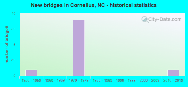
- New bridges - historical statistics
- 11950-1959
- 91970-1979
- 12010-2019


- Bridge Condition - Channel
- 50.0%Good
- 50.0%Satisfactory
Find on map >> Show street view
Structure Number: 119001, Location: 0.2 MI.S.JCT.SR3645 (Lat: 35.090522, Lng: -80.906867), Route carried "on" structure: State highway 51, Year Built: 2010, Status: Open, Structure Length: 0.70m (2.30ft), Average Daily Traffic: 14,000 (year 2012), Truck Traffic: 6%, Average Future Daily Traffic: 28,000 (year 2040), Design Load: HS 20+Mod, Features Intersected: MC CULLOUGH BRANCH
Minimum Vertical Clearance: 30+ m (98+ ft), Kilometerpoint: 0.000, Lanes on structure: 4, Owner: State Highway Agency, Approaching Roadway Width: 16.7m (54.8ft), Skew: 20 degrees, Material/Design: Concrete continuous, Design/Construction: Culvert, Number Of Spans In Main Unit: 3, Length of Maximum Span: 2.1m (6.9ft)
Condition: Channel: Satisfactory, Culverts: Satisfactory, Operating Rating: 58.0 metric tons, Method Used To Determine Operating Rating: Load and Resistance Factor (LRFR), Inventory Rating: 45.3 metric tons, Method Used To Determine Inventory Rating: Load and Resistance Factor (LRFR), Structural Evaluation: Equal to present minimum criteria, Waterway Adequacy: Better than present minimum criteria, Approach Roadway Alignment: Equal to present desirable criteria, Designated Inspection Frequency: Every 24 months, Inspection Date: September 2020
Find on map >> Show street view
Structure Number: 1190191, Location: 0.3 MI. N. JCT. SR2145 (Lat: 35.447564, Lng: -80.866594), Route carried "on" structure: US 21, Year Built: 1954, Status: Open, Structure Length: 0.88m (2.89ft), Average Daily Traffic: 27,000 (year 2018), Truck Traffic: 6%, Average Future Daily Traffic: 54,000 (year 2040), Design Load: HS 20+Mod, Features Intersected: CALDWELL STATION CREEK
Minimum Vertical Clearance: 30+ m (98+ ft), Kilometerpoint: 0.000, Lanes on structure: 2, Base Highway Network: Yes (Inventory Route: 2, Subroute: 21), Owner: State Highway Agency, Approaching Roadway Width: 10.3m (33.8ft), Skew: 3 degrees, Material/Design: Concrete continuous, Design/Construction: Culvert, Number Of Spans In Main Unit: 3, Length of Maximum Span: 2.4m (7.9ft)
Condition: Channel: Good, Culverts: Satisfactory, Operating Rating: 41.7 metric tons, Method Used To Determine Operating Rating: Field evaluation and documented engineering judgment, Inventory Rating: 32.6 metric tons, Method Used To Determine Inventory Rating: Field evaluation and documented engineering judgment, Structural Evaluation: Equal to present minimum criteria, Waterway Adequacy: Better than present minimum criteria, Approach Roadway Alignment: Equal to present desirable criteria, Designated Inspection Frequency: Every 24 months, Inspection Date: April 2021
Find on map >> Show street view
Structure Number: 1190362, Location: 0.3 MI. W. JCT. US21 (Lat: 35.463836, Lng: -80.875417), Route carried "on" structure: State highway 2147, Year Built: 1976, Status: Open, Structure Length: 9.20m (30.18ft), Average Daily Traffic: 12,000 (year 2018), Truck Traffic: 7%, Average Future Daily Traffic: 24,000 (year 2040), Design Load: HS 15, Features Intersected: I77
Minimum Vertical Clearance: 30+ m (98+ ft), Kilometerpoint: 0.000, Lanes on structure: 2, Lanes under structure: 8, Owner: State Highway Agency, Approaching Roadway Width: 7.3m (24.0ft), Skew: 1 degrees, Material/Design: Steel, Design/Construction: Stringer/Multi-beam, Number Of Spans In Main Unit: 4, Length of Maximum Span: 36.2m (118.8ft), Curb-To-Curb Width: 10.9m (35.8ft), Out-to-Out Width: 11.5m (37.7ft)
Condition: Deck: Satisfactory, Superstructure: Good, Substructure: Satisfactory, Operating Rating: 47.1 metric tons, Method Used To Determine Operating Rating: Load Factor (LF), Inventory Rating: 28.1 metric tons, Method Used To Determine Inventory Rating: Load Factor (LF), Structural Evaluation: Equal to present minimum criteria, Deck Geometry: Meets minimum limits, Underclear: High priority of corrective action, Approach Roadway Alignment: Equal to present desirable criteria, Designated Inspection Frequency: Every 24 months, Inspection Date: May 2021, Deck Structure Type: Concrete Cast-file-Place, Wearing Surface/Protective System: Wearing Surface: Monolithic Concrete
Find on map >> Show street view
Structure Number: 1190019, Location: 0.15 MI. E. JCT. SR2195 (Lat: 35.483528, Lng: -80.874714), Route carried "under" structure: Interstate 77, Year Built: 1976, Structure Length: 0. m, Average Daily Traffic: 10,000 (year 2018), Truck Traffic: 16%, Features Intersected: US21
Minimum Vertical Clearance: 5.28m (17.32ft), Kilometerpoint: 8.430, Lanes on structure: 5, Lanes under structure: 2, Material/Design: Steel, Design/Construction: Stringer/Multi-beam, Length of Maximum Span: 47.8m (156.8ft)
Find on map >> Show street view
Structure Number: 1190019, Location: 0.15 MI. E. JCT. SR2195 (Lat: 35.483528, Lng: -80.874714), Route carried "under" structure: Interstate 77, Year Built: 1976, Structure Length: 0. m, Average Daily Traffic: 25,000 (year 2018), Truck Traffic: 16%, Features Intersected: US21
Minimum Vertical Clearance: 4.97m (16.31ft), Kilometerpoint: 8.430, Lanes on structure: 5, Lanes under structure: 2, Material/Design: Steel, Design/Construction: Stringer/Multi-beam, Length of Maximum Span: 47.8m (156.8ft)
Find on map >> Show street view
Structure Number: 1190019, Location: 0.15 MI. E. JCT. SR2195 (Lat: 35.483528, Lng: -80.874714), Route carried "under" structure: Interstate 77, Year Built: 1976, Structure Length: 0. m, Average Daily Traffic: 25,000 (year 2018), Truck Traffic: 16%, Features Intersected: US21
Minimum Vertical Clearance: 5.63m (18.47ft), Kilometerpoint: 8.430, Lanes on structure: 5, Lanes under structure: 2, Material/Design: Steel, Design/Construction: Stringer/Multi-beam, Length of Maximum Span: 47.8m (156.8ft)
Find on map >> Show street view
Structure Number: 1190019, Location: 0.15 MI. E. JCT. SR2195 (Lat: 35.483528, Lng: -80.874714), Route carried "under" structure: Interstate 77, Year Built: 1976, Structure Length: 0. m, Average Daily Traffic: 10,000 (year 2018), Truck Traffic: 16%, Features Intersected: US21
Minimum Vertical Clearance: 4.93m (16.17ft), Kilometerpoint: 8.430, Lanes on structure: 5, Lanes under structure: 2, Material/Design: Steel, Design/Construction: Stringer/Multi-beam, Length of Maximum Span: 47.8m (156.8ft)
Find on map >> Show street view
Structure Number: 1190362, Location: 0.3 MI. W. JCT. US21 (Lat: 35.463836, Lng: -80.875417), Route carried "under" structure: Interstate 77, Year Built: 1976, Structure Length: 0. m, Average Daily Traffic: 20,125 (year 2018), Truck Traffic: 16%, Features Intersected: SR2147
Minimum Vertical Clearance: 4.96m (16.27ft), Kilometerpoint: 8.025, Lanes on structure: 2, Lanes under structure: 2, Material/Design: Steel, Design/Construction: Stringer/Multi-beam, Length of Maximum Span: 36.2m (118.8ft)
Find on map >> Show street view
Structure Number: 1190362, Location: 0.3 MI. W. JCT. US21 (Lat: 35.463836, Lng: -80.875417), Route carried "under" structure: Interstate 77, Year Built: 1976, Structure Length: 0. m, Average Daily Traffic: 20,125 (year 2018), Truck Traffic: 16%, Features Intersected: SR2147
Minimum Vertical Clearance: 5.37m (17.62ft), Kilometerpoint: 8.025, Lanes on structure: 2, Lanes under structure: 2, Material/Design: Steel, Design/Construction: Stringer/Multi-beam, Length of Maximum Span: 36.2m (118.8ft)
Find on map >> Show street view
Structure Number: 1190362, Location: 0.3 MI. W. JCT. US21 (Lat: 35.463836, Lng: -80.875417), Route carried "under" structure: Interstate 77, Year Built: 1976, Structure Length: 0. m, Average Daily Traffic: 20,125 (year 2018), Truck Traffic: 16%, Features Intersected: SR2147
Minimum Vertical Clearance: 4.70m (15.42ft), Kilometerpoint: 8.025, Lanes on structure: 2, Lanes under structure: 2, Material/Design: Steel, Design/Construction: Stringer/Multi-beam, Length of Maximum Span: 36.2m (118.8ft)
Find on map >> Show street view
Structure Number: 1190362, Location: 0.3 MI. W. JCT. US21 (Lat: 35.463836, Lng: -80.875417), Route carried "under" structure: Interstate 77, Year Built: 1976, Structure Length: 0. m, Average Daily Traffic: 20,125 (year 2015), Truck Traffic: 16%, Features Intersected: SR2147
Minimum Vertical Clearance: 5.24m (17.19ft), Kilometerpoint: 8.025, Lanes on structure: 2, Lanes under structure: 2, Material/Design: Steel, Design/Construction: Stringer/Multi-beam, Length of Maximum Span: 36.2m (118.8ft)