Bridge Statistics for Conyers, Georgia (GA)
Condition, Traffic, Stress, Structural Evaluation, Project Costs
- National Bridge Inventory (NBI) Statistics
- 43Number of bridges
- 518ft / 158mTotal length
- $40,867,000Total costs
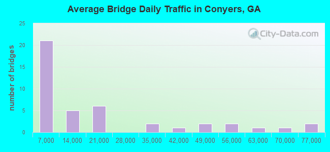
- 755,258Total average daily traffic
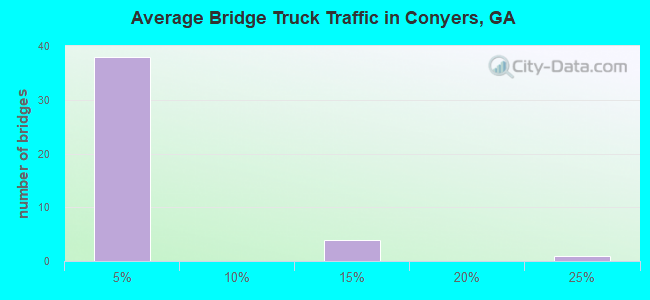
- 49,797Total average daily truck traffic
- National Bridge Inventory (NBI) Registered Bridges for Conyers
- No street view available for this location
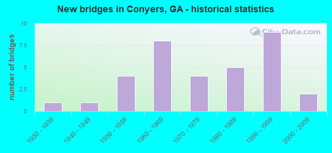
- New bridges - historical statistics
- 11930-1939
- 11940-1949
- 41950-1959
- 81960-1969
- 41970-1979
- 51980-1989
- 91990-1999
- 22000-2009
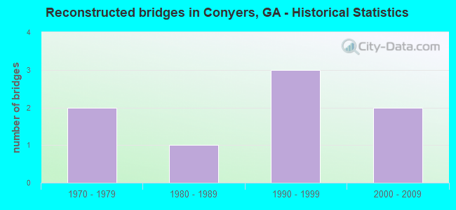
- Reconstructed bridges - Historical Statistics
- 21970-1979
- 11980-1989
- 31990-1999
- 22000-2009
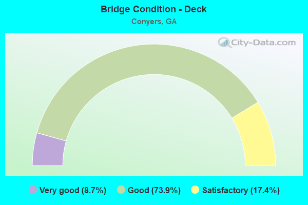
- Bridge Condition - Deck
- 8.7%Very good
- 73.9%Good
- 17.4%Satisfactory
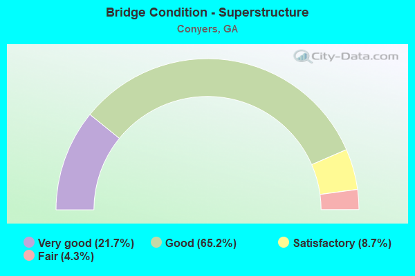
- Bridge Condition - Superstructure
- 21.7%Very good
- 65.2%Good
- 8.7%Satisfactory
- 4.3%Fair
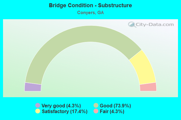
- Bridge Condition - Substructure
- 4.3%Very good
- 73.9%Good
- 17.4%Satisfactory
- 4.3%Fair
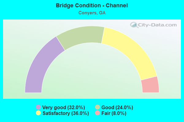
- Bridge Condition - Channel
- 32.0%Very good
- 24.0%Good
- 36.0%Satisfactory
- 8.0%Fair
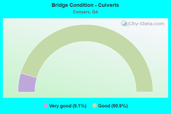
- Bridge Condition - Culverts
- 9.1%Very good
- 90.9%Good
Find on map >> Show street view
Structure Number: 2170023, Location: .25 MI E ROCKDALE CO LINE (Lat: 33.628278, Lng: -83.947997), Route carried "on" structure: County highway 301, Year Built: 1964, Status: Open, Structure Length: 6.46m (21.19ft), Average Daily Traffic: 1,940 (year 2011), Truck Traffic: 1%, Average Future Daily Traffic: 2,910 (year 2031), Design Load: H 15, Features Intersected: I-20, Facility Carried by Structure: ALMON ROAD
Minimum Vertical Clearance: 30+ m (98+ ft), Kilometerpoint: 0.000, Lanes on structure: 2, Lanes under structure: 6, Base Highway Network: Yes, Owner: State Highway Agency, Approaching Roadway Width: 6.1m (20.0ft), Material/Design: Steel continuous, Design/Construction: Stringer/Multi-beam, Number Of Spans In Main Unit: 4, Length of Maximum Span: 18.0m (59.1ft), Curb or Sidewalk Widths: Left: 0.6m (2.0ft), Right: 0.6m (2.0ft), Curb-To-Curb Width: 7.3m (24.0ft), Out-to-Out Width: 9.2m (30.2ft)
Condition: Deck: Satisfactory, Superstructure: Fair, Substructure: Good, Operating Rating: 35.3 metric tons, Method Used To Determine Operating Rating: Load Factor (LF), Inventory Rating: 21.7 metric tons, Method Used To Determine Inventory Rating: Load Factor (LF), Structural Evaluation: Somewhat better than minimum adequacy, Deck Geometry: Meets minimum limits, Underclear: Meets minimum limits, Approach Roadway Alignment: Equal to present minimum criteria, Length Of Structure Improvement: 46.70m (153.22ft), Designated Inspection Frequency: Every 24 months, Inspection Date: January 2021, Bridge Improvement Cost: $828,000, Roadway Improvement Cost: $83,000, Total Project Cost: $1,242,000, Deck Structure Type: Concrete Cast-file-Place
Find on map >> Show street view
Structure Number: 2170043, Location: 5 MI N OF COVINGTON (Lat: 33.688619, Lng: -83.893558), Route carried "on" structure: County highway 1050, Year Built: 1958, Status: Open, Structure Length: 0.64m (2.10ft), Average Daily Traffic: 1,800 (year 2011), Truck Traffic: 1%, Average Future Daily Traffic: 2,700 (year 2031), Design Load: H 15, Features Intersected: GUM CREEK TRIB, Facility Carried by Structure: GUM CREEK ROAD
Minimum Vertical Clearance: 30+ m (98+ ft), Kilometerpoint: 6.437, Lanes on structure: 2, Base Highway Network: Yes, Owner: County Highway Agency, Approaching Roadway Width: 6.7m (22.0ft), Material/Design: Concrete, Design/Construction: Culvert, Number Of Spans In Main Unit: 2, Length of Maximum Span: 3.0m (9.8ft)
Condition: Channel: Satisfactory, Culverts: Good, Operating Rating: 41.7 metric tons, Method Used To Determine Operating Rating: Field evaluation and documented engineering judgment, Inventory Rating: 24.4 metric tons, Method Used To Determine Inventory Rating: Field evaluation and documented engineering judgment, Structural Evaluation: Equal to present minimum criteria, Waterway Adequacy: Equal to present minimum criteria, Approach Roadway Alignment: Better than present minimum criteria, Designated Inspection Frequency: Every 24 months, Inspection Date: Febuary 2021, Bridge Improvement Cost: $82,000, Roadway Improvement Cost: $8,000, Total Project Cost: $123,000
Find on map >> Show street view
Structure Number: 2175008, Location: 3 MI W OF OXFORD (Lat: 33.628308, Lng: -83.920728), Route carried "on" structure: County highway 49, Year Built: 1985, Year Reconstructed: 2013, Status: Open, Structure Length: 7.32m (24.02ft), Average Daily Traffic: 1,930 (year 2012), Truck Traffic: 1%, Average Future Daily Traffic: 2,895 (year 2032), Design Load: HS 15, Features Intersected: YELLOW RIVER, Facility Carried by Structure: TABOR ROAD
Minimum Vertical Clearance: 30+ m (98+ ft), Kilometerpoint: 1.609, Lanes on structure: 2, Base Highway Network: Yes, Owner: County Highway Agency, Approaching Roadway Width: 6.1m (20.0ft), Material/Design: Prestressed concrete, Design/Construction: Stringer/Multi-beam, Number Of Spans In Main Unit: 1, Number Of Approach Spans: 4, Length of Maximum Span: 24.4m (80.1ft), Curb-To-Curb Width: 7.3m (24.0ft), Out-to-Out Width: 8.1m (26.6ft)
Condition: Deck: Very good, Superstructure: Good, Substructure: Good, Channel: Good, Operating Rating: 42.6 metric tons, Method Used To Determine Operating Rating: Load Factor (LF), Inventory Rating: 25.4 metric tons, Method Used To Determine Inventory Rating: Load Factor (LF), Structural Evaluation: Equal to present minimum criteria, Deck Geometry: Meets minimum limits, Waterway Adequacy: Equal to present desirable criteria, Approach Roadway Alignment: Equal to present desirable criteria, Designated Inspection Frequency: Every 24 months, Underwater Inspection Frequency: Every 60 months, Inspection Date: January 2021, Underwater Inspection Date: September 2018, Bridge Improvement Cost: $938,000, Roadway Improvement Cost: $94,000, Total Project Cost: $1,407,000, Deck Structure Type: Concrete Cast-file-Place, Wearing Surface/Protective System: Wearing Surface: Bituminous
Find on map >> Show street view
Structure Number: 2175014, Location: 4 MI NW OF OXFORD (Lat: 33.691769, Lng: -83.902869), Route carried "on" structure: County highway 89, Year Built: 1980, Status: Posted for load, Structure Length: 5.18m (16.99ft), Average Daily Traffic: 1,330 (year 2011), Truck Traffic: 1%, Average Future Daily Traffic: 1,995 (year 2031), Design Load: HS 15, Features Intersected: GUM CREEK, Facility Carried by Structure: DIAL MILL ROAD
Minimum Vertical Clearance: 30+ m (98+ ft), Kilometerpoint: 1.609, Lanes on structure: 2, Base Highway Network: Yes, Owner: County Highway Agency, Approaching Roadway Width: 6.1m (20.0ft), Skew: 4 degrees, Material/Design: Concrete, Design/Construction: Tee Beam, Number Of Spans In Main Unit: 5, Length of Maximum Span: 10.4m (34.1ft), Curb-To-Curb Width: 9.3m (30.5ft), Out-to-Out Width: 10.3m (33.8ft)
Condition: Deck: Good, Superstructure: Good, Substructure: Good, Channel: Fair, Operating Rating: 32.6 metric tons, Method Used To Determine Operating Rating: Load Factor (LF), Inventory Rating: 19.0 metric tons, Method Used To Determine Inventory Rating: Load Factor (LF), Structural Evaluation: Somewhat better than minimum adequacy, Deck Geometry: Somewhat better than minimum adequacy, Waterway Adequacy: Equal to present desirable criteria, Approach Roadway Alignment: Equal to present desirable criteria, Bridge Posting: Required (Relationship of Operating Rating to Maximum Legal Load: 0.1 - 9.9% below), Designated Inspection Frequency: Every 24 months, Inspection Date: Febuary 2021, Bridge Improvement Cost: $664,000, Roadway Improvement Cost: $66,000, Total Project Cost: $996,000, Deck Structure Type: Concrete Cast-file-Place
Find on map >> Show street view
Structure Number: 2175046, Location: AT THE ROCKDALE CO LINE (Lat: 33.711128, Lng: -83.914289), Route carried "on" structure: County highway 89, Year Built: 1970, Status: Posted for load, Structure Length: 3.05m (10.01ft), Average Daily Traffic: 1,330 (year 2011), Truck Traffic: 1%, Average Future Daily Traffic: 1,995 (year 2031), Design Load: H 15, Features Intersected: LITTLE HAYNES CREEK, Facility Carried by Structure: DIAL MILL ROAD
Minimum Vertical Clearance: 30+ m (98+ ft), Kilometerpoint: 3.219, Lanes on structure: 2, Base Highway Network: Yes, Owner: County Highway Agency, Approaching Roadway Width: 5.5m (18.0ft), Material/Design: Steel continuous, Design/Construction: Stringer/Multi-beam, Number Of Spans In Main Unit: 4, Length of Maximum Span: 7.6m (24.9ft), Curb-To-Curb Width: 7.3m (24.0ft), Out-to-Out Width: 7.9m (25.9ft)
Condition: Deck: Satisfactory, Superstructure: Satisfactory, Substructure: Fair, Channel: Satisfactory, Operating Rating: 16.3 metric tons, Method Used To Determine Operating Rating: Allowable Stress (AS), Inventory Rating: 9.0 metric tons, Method Used To Determine Inventory Rating: Allowable Stress (AS), Structural Evaluation: High priority of corrective action, Deck Geometry: Meets minimum limits, Waterway Adequacy: Better than present minimum criteria, Approach Roadway Alignment: Meets minimum limits, Bridge Posting: Required (Relationship of Operating Rating to Maximum Legal Load: 10.0 - 19.9% below), Length Of Structure Improvement: 43.34m (142.19ft), Designated Inspection Frequency: Every 24 months, Inspection Date: Febuary 2021, Bridge Improvement Cost: $391,000, Roadway Improvement Cost: $39,000, Total Project Cost: $586,000, Deck Structure Type: Concrete Cast-file-Place
Find on map >> Show street view
Structure Number: 2470001, Location: 2.5 MI SE OF CONYERS (Lat: 33.609889, Lng: -84.014808), Route carried "on" structure: State highway 20, Year Built: 1936, Year Reconstructed: 1999, Status: Open, Structure Length: 0.98m (3.22ft), Average Daily Traffic: 31,060 (year 2012), Truck Traffic: 1%, Average Future Daily Traffic: 46,590 (year 2032), Design Load: H 15, Features Intersected: ALMOND BRANCH, Facility Carried by Structure: MCDONOUGH ROAD
Minimum Vertical Clearance: 30+ m (98+ ft), Kilometerpoint: 22.531, Lanes on structure: 4, Base Highway Network: Yes, Owner: State Highway Agency, Approaching Roadway Width: 17.1m (56.1ft), Skew: 29 degrees, Material/Design: Concrete, Design/Construction: Culvert, Number Of Spans In Main Unit: 3, Length of Maximum Span: 3.0m (9.8ft)
Condition: Channel: Good, Culverts: Good, Operating Rating: 43.5 metric tons, Method Used To Determine Operating Rating: Field evaluation and documented engineering judgment, Inventory Rating: 24.4 metric tons, Method Used To Determine Inventory Rating: Field evaluation and documented engineering judgment, Structural Evaluation: Equal to present minimum criteria, Waterway Adequacy: Equal to present minimum criteria, Approach Roadway Alignment: Equal to present desirable criteria, Designated Inspection Frequency: Every 24 months, Inspection Date: April 2021, Bridge Improvement Cost: $193,000, Roadway Improvement Cost: $19,000, Total Project Cost: $290,000
Find on map >> Show street view
Structure Number: 2470002, Location: 0.5 MI E OF CONYERS (Lat: 33.653667, Lng: -84.005511), Route carried "on" structure: State highway 20, Year Built: 1963, Year Reconstructed: 1978, Status: Open, Structure Length: 7.10m (23.29ft), Average Daily Traffic: 54,000 (year 2012), Truck Traffic: 4%, Average Future Daily Traffic: 81,000 (year 2032), Design Load: HS 20+Mod, Features Intersected: I-20
Minimum Vertical Clearance: 30+ m (98+ ft), Kilometerpoint: 17.703, Lanes on structure: 6, Lanes under structure: 6, Base Highway Network: Yes, Owner: State Highway Agency, Approaching Roadway Width: 20.1m (65.9ft), Skew: 2 degrees, Material/Design: Concrete, Design/Construction: Tee Beam, Number Of Spans In Main Unit: 4, Length of Maximum Span: 20.4m (66.9ft), Curb or Sidewalk Widths: Left: 1.5m (4.9ft), Right: 1.5m (4.9ft), Curb-To-Curb Width: 20.2m (66.3ft), Out-to-Out Width: 23.9m (78.4ft)
Condition: Deck: Good, Superstructure: Satisfactory, Substructure: Satisfactory, Operating Rating: 60.7 metric tons, Method Used To Determine Operating Rating: Load Factor (LF), Inventory Rating: 29.0 metric tons, Method Used To Determine Inventory Rating: Load Factor (LF), Structural Evaluation: Equal to present minimum criteria, Deck Geometry: High priority of replacement, Underclear: Meets minimum limits, Approach Roadway Alignment: Equal to present desirable criteria, Designated Inspection Frequency: Every 24 months, Inspection Date: April 2021, Bridge Improvement Cost: $1,904,000, Roadway Improvement Cost: $190,000, Total Project Cost: $2,855,000, Deck Structure Type: Concrete Cast-file-Place, Wearing Surface/Protective System: Wearing Surface: Bituminous
Find on map >> Show street view
Structure Number: 2470003, Location: 2 MI N OF CONYERS (Lat: 33.692319, Lng: -83.996878), Route carried "on" structure: State highway 20, Year Built: 1950, Year Reconstructed: 1990, Status: Open, Structure Length: 8.32m (27.30ft), Average Daily Traffic: 13,760 (year 2012), Truck Traffic: 1%, Average Future Daily Traffic: 20,640 (year 2032), Design Load: H 15, Features Intersected: YELLOW RIVER
Minimum Vertical Clearance: 30+ m (98+ ft), Kilometerpoint: 11.265, Lanes on structure: 3, Base Highway Network: Yes, Owner: State Highway Agency, Approaching Roadway Width: 11.0m (36.1ft), Material/Design: Steel continuous, Design/Construction: Stringer/Multi-beam, Number Of Spans In Main Unit: 5, Length of Maximum Span: 21.3m (69.9ft), Curb-To-Curb Width: 17.1m (56.1ft), Out-to-Out Width: 18.0m (59.1ft)
Condition: Deck: Good, Superstructure: Good, Substructure: Satisfactory, Channel: Satisfactory, Operating Rating: 30.8 metric tons, Method Used To Determine Operating Rating: Load Factor (LF), Inventory Rating: 18.1 metric tons, Method Used To Determine Inventory Rating: Load Factor (LF), Structural Evaluation: Meets minimum limits, Deck Geometry: Superior to present desirable criteria, Waterway Adequacy: Equal to present minimum criteria, Approach Roadway Alignment: Better than present minimum criteria, Designated Inspection Frequency: Every 24 months, Underwater Inspection Frequency: Every 60 months, Inspection Date: April 2021, Underwater Inspection Date: March 2019, Bridge Improvement Cost: $1,358,000, Roadway Improvement Cost: $136,000, Total Project Cost: $2,036,000, Deck Structure Type: Concrete Cast-file-Place
Find on map >> Show street view
Structure Number: 2470009, Location: 2 MI S OF CONYERS (Lat: 33.632289, Lng: -84.035300), Route carried "on" structure: State highway 138, Year Built: 1948, Year Reconstructed: 1991, Status: Open, Structure Length: 0.79m (2.59ft), Average Daily Traffic: 15,360 (year 2012), Truck Traffic: 2%, Average Future Daily Traffic: 23,040 (year 2032), Design Load: H 15, Features Intersected: ALMOND BRANCH
Minimum Vertical Clearance: 30+ m (98+ ft), Kilometerpoint: 12.875, Lanes on structure: 2, Base Highway Network: Yes, Owner: State Highway Agency, Approaching Roadway Width: 7.3m (24.0ft), Material/Design: Concrete, Design/Construction: Culvert, Number Of Spans In Main Unit: 3, Length of Maximum Span: 2.4m (7.9ft)
Condition: Channel: Very good, Culverts: Good, Operating Rating: 43.5 metric tons, Method Used To Determine Operating Rating: Field evaluation and documented engineering judgment, Inventory Rating: 24.4 metric tons, Method Used To Determine Inventory Rating: Field evaluation and documented engineering judgment, Structural Evaluation: Equal to present minimum criteria, Waterway Adequacy: Equal to present minimum criteria, Approach Roadway Alignment: Better than present minimum criteria, Designated Inspection Frequency: Every 24 months, Underwater Inspection Frequency: Every 60 months, Inspection Date: April 2021, Underwater Inspection Date: March 2019, Bridge Improvement Cost: $102,000, Roadway Improvement Cost: $10,000, Total Project Cost: $152,000
Find on map >> Show street view
Structure Number: 247001, Location: 1 MI E OF CONYERS (Lat: 33.656428, Lng: -84.002578), Route carried "on" structure: State highway 20, Year Built: 1963, Year Reconstructed: 2006, Status: Open, Structure Length: 4.30m (14.11ft), Average Daily Traffic: 45,300 (year 2012), Truck Traffic: 1%, Average Future Daily Traffic: 67,950 (year 2032), Design Load: HS 20, Features Intersected: CSX RAILROAD
Minimum Vertical Clearance: 30+ m (98+ ft), Kilometerpoint: 17.703, Lanes on structure: 6, Base Highway Network: Yes, Owner: State Highway Agency, Approaching Roadway Width: 24.4m (80.1ft), Skew: 22 degrees, Material/Design: Steel, Design/Construction: Stringer/Multi-beam, Number Of Spans In Main Unit: 3, Length of Maximum Span: 14.3m (46.9ft), Curb or Sidewalk Widths: Left: 1.8m (5.9ft), Right: 1.8m (5.9ft), Curb-To-Curb Width: 28.6m (93.8ft), Out-to-Out Width: 33.0m (108.3ft)
Condition: Deck: Good, Superstructure: Very good, Substructure: Good, Operating Rating: 36.2 metric tons, Method Used To Determine Operating Rating: Load Factor (LF), Inventory Rating: 21.7 metric tons, Method Used To Determine Inventory Rating: Load Factor (LF), Structural Evaluation: Somewhat better than minimum adequacy, Deck Geometry: Superior to present desirable criteria, Underclear: Equal to present minimum criteria, Approach Roadway Alignment: Equal to present desirable criteria, Designated Inspection Frequency: Every 24 months, Inspection Date: April 2021, Bridge Improvement Cost: $1,152,000, Roadway Improvement Cost: $115,000, Total Project Cost: $1,728,000, Deck Structure Type: Concrete Cast-file-Place
Find on map >> Show street view
Structure Number: 2470011, Location: 3 MI NE OF CONYERS (Lat: 33.687358, Lng: -83.962019), Route carried "on" structure: State highway 138, Year Built: 1957, Year Reconstructed: 1995, Status: Open, Structure Length: 7.16m (23.49ft), Average Daily Traffic: 16,050 (year 2012), Truck Traffic: 1%, Average Future Daily Traffic: 24,075 (year 2032), Design Load: H 20, Features Intersected: YELLOW RIVER
Minimum Vertical Clearance: 30+ m (98+ ft), Kilometerpoint: 22.531, Lanes on structure: 2, Base Highway Network: Yes, Owner: State Highway Agency, Approaching Roadway Width: 9.1m (29.9ft), Skew: 12 degrees, Material/Design: Steel, Design/Construction: Stringer/Multi-beam, Number Of Spans In Main Unit: 6, Length of Maximum Span: 18.3m (60.0ft), Curb-To-Curb Width: 11.5m (37.7ft), Out-to-Out Width: 12.1m (39.7ft)
Condition: Deck: Satisfactory, Superstructure: Good, Substructure: Satisfactory, Channel: Satisfactory, Operating Rating: 37.1 metric tons, Method Used To Determine Operating Rating: Load Factor (LF), Inventory Rating: 22.6 metric tons, Method Used To Determine Inventory Rating: Load Factor (LF), Structural Evaluation: Somewhat better than minimum adequacy, Deck Geometry: Equal to present minimum criteria, Waterway Adequacy: Equal to present desirable criteria, Approach Roadway Alignment: Equal to present desirable criteria, Designated Inspection Frequency: Every 24 months, Underwater Inspection Frequency: Every 60 months, Inspection Date: April 2021, Underwater Inspection Date: March 2019, Bridge Improvement Cost: $918,000, Roadway Improvement Cost: $92,000, Total Project Cost: $1,377,000, Deck Structure Type: Concrete Cast-file-Place
Find on map >> Show street view
Structure Number: 2470012, Location: 4.5 MI NE OF CONYERS (Lat: 33.711558, Lng: -83.931008), Route carried "on" structure: State highway 138, Year Built: 1962, Status: Open, Structure Length: 5.49m (18.01ft), Average Daily Traffic: 15,780 (year 2012), Truck Traffic: 1%, Average Future Daily Traffic: 23,670 (year 2032), Design Load: H 20, Features Intersected: BIG HAYNES CREEK
Minimum Vertical Clearance: 30+ m (98+ ft), Kilometerpoint: 27.359, Lanes on structure: 2, Base Highway Network: Yes, Owner: State Highway Agency, Approaching Roadway Width: 8.2m (26.9ft), Skew: 4 degrees, Material/Design: Concrete, Design/Construction: Tee Beam, Number Of Spans In Main Unit: 5, Length of Maximum Span: 11.0m (36.1ft), Curb or Sidewalk Widths: Left: 0.6m (2.0ft), Right: 0.6m (2.0ft), Curb-To-Curb Width: 8.5m (27.9ft), Out-to-Out Width: 10.5m (34.4ft)
Condition: Deck: Good, Superstructure: Good, Substructure: Good, Channel: Satisfactory, Operating Rating: 41.7 metric tons, Method Used To Determine Operating Rating: Load Factor (LF), Inventory Rating: 25.4 metric tons, Method Used To Determine Inventory Rating: Load Factor (LF), Structural Evaluation: Equal to present minimum criteria, Deck Geometry: High priority of replacement, Waterway Adequacy: Equal to present minimum criteria, Approach Roadway Alignment: Better than present minimum criteria, Length Of Structure Improvement: 45.72m (150.00ft), Designated Inspection Frequency: Every 24 months, Underwater Inspection Frequency: Every 60 months, Inspection Date: April 2021, Underwater Inspection Date: March 2019, Bridge Improvement Cost: $703,000, Roadway Improvement Cost: $70,000, Total Project Cost: $1,055,000, Deck Structure Type: Concrete Cast-file-Place
Find on map >> Show street view
Structure Number: 2470013, Location: 5.5 MI NE OF CONYERS (Lat: 33.721958, Lng: -83.918197), Route carried "on" structure: State highway 138, Year Built: 1962, Status: Open, Structure Length: 4.57m (14.99ft), Average Daily Traffic: 15,780 (year 2012), Truck Traffic: 1%, Average Future Daily Traffic: 23,670 (year 2032), Design Load: H 20, Features Intersected: LITTLE HAYNES CREEK
Minimum Vertical Clearance: 30+ m (98+ ft), Kilometerpoint: 28.968, Lanes on structure: 2, Base Highway Network: Yes, Owner: State Highway Agency, Approaching Roadway Width: 8.8m (28.9ft), Skew: 3 degrees, Material/Design: Concrete, Design/Construction: Tee Beam, Number Of Spans In Main Unit: 5, Length of Maximum Span: 9.1m (29.9ft), Curb or Sidewalk Widths: Left: 0.6m (2.0ft), Right: 0.6m (2.0ft), Curb-To-Curb Width: 8.5m (27.9ft), Out-to-Out Width: 10.5m (34.4ft)
Condition: Deck: Good, Superstructure: Good, Substructure: Satisfactory, Channel: Fair, Operating Rating: 51.7 metric tons, Method Used To Determine Operating Rating: Load Factor (LF), Inventory Rating: 31.7 metric tons, Method Used To Determine Inventory Rating: Load Factor (LF), Structural Evaluation: Equal to present minimum criteria, Deck Geometry: High priority of replacement, Waterway Adequacy: Equal to present minimum criteria, Approach Roadway Alignment: Equal to present minimum criteria, Length Of Structure Improvement: 44.81m (147.01ft), Designated Inspection Frequency: Every 24 months, Inspection Date: April 2021, Bridge Improvement Cost: $586,000, Roadway Improvement Cost: $59,000, Total Project Cost: $879,000, Deck Structure Type: Concrete Cast-file-Place
Find on map >> Show street view
Structure Number: 2470019, Location: IN CONYERS (Lat: 33.664797, Lng: -84.029550), Route carried "on" structure: City street 9338, Year Built: 1962, Year Reconstructed: 1978, Status: Open, Structure Length: 8.20m (26.90ft), Average Daily Traffic: 12,670 (year 2012), Truck Traffic: 1%, Average Future Daily Traffic: 19,005 (year 2032), Design Load: HS 20+Mod, Features Intersected: I-20, Facility Carried by Structure: KLONDIKE ROAD
Minimum Vertical Clearance: 30+ m (98+ ft), Kilometerpoint: 6.437, Lanes on structure: 5, Lanes under structure: 6, Base Highway Network: Yes, Owner: State Highway Agency, Approaching Roadway Width: 20.1m (65.9ft), Skew: 4 degrees, Material/Design: Steel, Design/Construction: Stringer/Multi-beam, Number Of Spans In Main Unit: 4, Length of Maximum Span: 25.6m (84.0ft), Curb or Sidewalk Widths: Left: 1.5m (4.9ft), Right: 1.5m (4.9ft), Curb-To-Curb Width: 20.1m (65.9ft), Out-to-Out Width: 23.9m (78.4ft)
Condition: Deck: Good, Superstructure: Good, Substructure: Good, Operating Rating: 63.5 metric tons, Method Used To Determine Operating Rating: Load Factor (LF), Inventory Rating: 38.1 metric tons, Method Used To Determine Inventory Rating: Load Factor (LF), Structural Evaluation: Better than present minimum criteria, Deck Geometry: Somewhat better than minimum adequacy, Underclear: High priority of corrective action, Approach Roadway Alignment: Equal to present desirable criteria, Designated Inspection Frequency: Every 24 months, Inspection Date: April 2021, Bridge Improvement Cost: $1,911,000, Roadway Improvement Cost: $191,000, Total Project Cost: $2,866,000, Deck Structure Type: Concrete Cast-file-Place
Find on map >> Show street view
Structure Number: 2470022, Location: 3.2 MI SW OF CONYERS (Lat: 33.620756, Lng: -84.069397), Route carried "on" structure: State highway 138, Year Built: 1991, Status: Open, Structure Length: 4.57m (14.99ft), Average Daily Traffic: 10,210 (year 2012), Truck Traffic: 1%, Average Future Daily Traffic: 15,315 (year 2032), Design Load: HS 20+Mod, Features Intersected: HONEY CREEK
Minimum Vertical Clearance: 30+ m (98+ ft), Kilometerpoint: 9.656, Lanes on structure: 2, Base Highway Network: Yes, Owner: State Highway Agency, Approaching Roadway Width: 8.5m (27.9ft), Skew: 2 degrees, Material/Design: Prestressed concrete, Design/Construction: Stringer/Multi-beam, Number Of Spans In Main Unit: 3, Length of Maximum Span: 15.2m (49.9ft), Curb-To-Curb Width: 13.4m (44.0ft), Out-to-Out Width: 14.4m (47.2ft)
Condition: Deck: Good, Superstructure: Good, Substructure: Good, Channel: Very good, Operating Rating: 68.0 metric tons, Method Used To Determine Operating Rating: Load Factor (LF), Inventory Rating: 40.8 metric tons, Method Used To Determine Inventory Rating: Load Factor (LF), Structural Evaluation: Better than present minimum criteria, Deck Geometry: Equal to present minimum criteria, Waterway Adequacy: Superior to present desirable criteria, Approach Roadway Alignment: Equal to present desirable criteria, Designated Inspection Frequency: Every 24 months, Inspection Date: April 2021, Bridge Improvement Cost: $586,000, Roadway Improvement Cost: $59,000, Total Project Cost: $879,000, Deck Structure Type: Concrete Cast-file-Place
Find on map >> Show street view
Structure Number: 2475002, Location: 4 MI SW OF CONYERS (Lat: 33.604050, Lng: -84.063578), Route carried "on" structure: County highway 22, Year Built: 1984, Status: Open, Structure Length: 2.87m (9.42ft), Average Daily Traffic: 2,120 (year 2012), Truck Traffic: 1%, Average Future Daily Traffic: 3,180 (year 2032), Design Load: HS 15, Features Intersected: HONEY CREEK, Facility Carried by Structure: TUCKER MILL ROAD
Minimum Vertical Clearance: 30+ m (98+ ft), Kilometerpoint: 3.219, Lanes on structure: 2, Base Highway Network: Yes, Owner: County Highway Agency, Approaching Roadway Width: 7.3m (24.0ft), Material/Design: Concrete, Design/Construction: Tee Beam, Number Of Spans In Main Unit: 3, Length of Maximum Span: 12.2m (40.0ft), Curb-To-Curb Width: 9.3m (30.5ft), Out-to-Out Width: 10.3m (33.8ft)
Condition: Deck: Good, Superstructure: Good, Substructure: Good, Channel: Good, Operating Rating: 41.7 metric tons, Method Used To Determine Operating Rating: Load Factor (LF), Inventory Rating: 24.4 metric tons, Method Used To Determine Inventory Rating: Load Factor (LF), Structural Evaluation: Equal to present minimum criteria, Deck Geometry: Meets minimum limits, Waterway Adequacy: Equal to present desirable criteria, Approach Roadway Alignment: Equal to present minimum criteria, Designated Inspection Frequency: Every 24 months, Inspection Date: April 2021, Bridge Improvement Cost: $367,000, Roadway Improvement Cost: $37,000, Total Project Cost: $551,000, Deck Structure Type: Concrete Cast-file-Place
Find on map >> Show street view
Structure Number: 2475003, Location: 4 MI SW OF CONYERS (Lat: 33.593447, Lng: -84.053839), Route carried "on" structure: County highway 23, Year Built: 1974, Status: Open, Structure Length: 0.67m (2.20ft), Average Daily Traffic: 2,420 (year 2012), Truck Traffic: 1%, Average Future Daily Traffic: 3,630 (year 2032), Design Load: HS 20+Mod, Features Intersected: HONEY CREEK TRIB., Facility Carried by Structure: HONEY CREEK ROAD
Minimum Vertical Clearance: 30+ m (98+ ft), Kilometerpoint: 3.219, Lanes on structure: 2, Base Highway Network: Yes, Owner: County Highway Agency, Approaching Roadway Width: 7.0m (23.0ft), Skew: 3 degrees, Material/Design: Concrete, Design/Construction: Culvert, Number Of Spans In Main Unit: 2, Length of Maximum Span: 3.0m (9.8ft)
Condition: Channel: Satisfactory, Culverts: Good, Operating Rating: 55.3 metric tons, Method Used To Determine Operating Rating: Field evaluation and documented engineering judgment, Inventory Rating: 32.6 metric tons, Method Used To Determine Inventory Rating: Field evaluation and documented engineering judgment, Structural Evaluation: Better than present minimum criteria, Waterway Adequacy: Equal to present desirable criteria, Approach Roadway Alignment: Equal to present minimum criteria, Designated Inspection Frequency: Every 24 months, Inspection Date: April 2021, Bridge Improvement Cost: $86,000, Roadway Improvement Cost: $9,000, Total Project Cost: $129,000
Find on map >> Show street view
Structure Number: 2475004, Location: 4 MI SW OF CONYERS (Lat: 33.595639, Lng: -84.061700), Route carried "on" structure: County highway 23, Year Built: 1974, Status: Open, Structure Length: 1.31m (4.30ft), Average Daily Traffic: 2,420 (year 2012), Truck Traffic: 1%, Average Future Daily Traffic: 3,630 (year 2032), Design Load: HS 20+Mod, Features Intersected: HONEY CREEK, Facility Carried by Structure: HONEY CREEK ROAD
Minimum Vertical Clearance: 30+ m (98+ ft), Kilometerpoint: 4.828, Lanes on structure: 2, Base Highway Network: Yes, Owner: County Highway Agency, Approaching Roadway Width: 7.0m (23.0ft), Material/Design: Concrete, Design/Construction: Culvert, Number Of Spans In Main Unit: 4, Length of Maximum Span: 3.0m (9.8ft)
Condition: Channel: Good, Culverts: Good, Operating Rating: 55.3 metric tons, Method Used To Determine Operating Rating: Field evaluation and documented engineering judgment, Inventory Rating: 32.6 metric tons, Method Used To Determine Inventory Rating: Field evaluation and documented engineering judgment, Structural Evaluation: Better than present minimum criteria, Waterway Adequacy: Equal to present minimum criteria, Approach Roadway Alignment: Better than present minimum criteria, Designated Inspection Frequency: Every 24 months, Inspection Date: April 2021, Bridge Improvement Cost: $168,000, Roadway Improvement Cost: $17,000, Total Project Cost: $252,000
Find on map >> Show street view
Structure Number: 2475005, Location: 5 MI S OF CONYERS (Lat: 33.578239, Lng: -84.042669), Route carried "on" structure: County highway 34, Year Built: 1960, Status: Open, Structure Length: 0.88m (2.89ft), Average Daily Traffic: 3,450 (year 2012), Truck Traffic: 1%, Average Future Daily Traffic: 5,175 (year 2032), Design Load: H 15, Features Intersected: McCLAIN BRANCH, Facility Carried by Structure: TROUPE SMITH ROAD
Minimum Vertical Clearance: 30+ m (98+ ft), Kilometerpoint: 1.609, Lanes on structure: 2, Base Highway Network: Yes, Owner: County Highway Agency, Approaching Roadway Width: 6.7m (22.0ft), Skew: 4 degrees, Material/Design: Concrete, Design/Construction: Culvert, Number Of Spans In Main Unit: 2, Length of Maximum Span: 4.3m (14.1ft)
Condition: Channel: Good, Culverts: Good, Operating Rating: 43.5 metric tons, Method Used To Determine Operating Rating: Field evaluation and documented engineering judgment, Inventory Rating: 24.4 metric tons, Method Used To Determine Inventory Rating: Field evaluation and documented engineering judgment, Structural Evaluation: Equal to present minimum criteria, Waterway Adequacy: Better than present minimum criteria, Approach Roadway Alignment: Equal to present minimum criteria, Designated Inspection Frequency: Every 24 months, Inspection Date: April 2021, Bridge Improvement Cost: $113,000, Roadway Improvement Cost: $11,000, Total Project Cost: $170,000
Find on map >> Show street view
Structure Number: 2475007, Location: 4 MI S OF CONYERS (Lat: 33.590619, Lng: -83.992639), Route carried "on" structure: County highway 505, Year Built: 1967, Status: Posted for load, Structure Length: 3.66m (12.01ft), Average Daily Traffic: 8,610 (year 2012), Truck Traffic: 1%, Average Future Daily Traffic: 12,915 (year 2032), Design Load: H 15, Features Intersected: SNAPPING SHOALS CREEK, Facility Carried by Structure: HONEY CREEK ROAD
Minimum Vertical Clearance: 30+ m (98+ ft), Kilometerpoint: 0.000, Lanes on structure: 2, Base Highway Network: Yes, Owner: County Highway Agency, Approaching Roadway Width: 6.1m (20.0ft), Skew: 3 degrees, Material/Design: Concrete, Design/Construction: Tee Beam, Number Of Spans In Main Unit: 4, Length of Maximum Span: 9.1m (29.9ft), Curb or Sidewalk Widths: Left: 0.6m (2.0ft), Right: 0.6m (2.0ft), Curb-To-Curb Width: 7.9m (25.9ft), Out-to-Out Width: 9.8m (32.2ft)
Condition: Deck: Satisfactory, Superstructure: Good, Substructure: Good, Channel: Very good, Operating Rating: 30.8 metric tons, Method Used To Determine Operating Rating: Load Factor (LF), Inventory Rating: 18.1 metric tons, Method Used To Determine Inventory Rating: Load Factor (LF), Structural Evaluation: Meets minimum limits, Deck Geometry: High priority of replacement, Waterway Adequacy: Equal to present desirable criteria, Approach Roadway Alignment: Somewhat better than minimum adequacy, Bridge Posting: Required (Relationship of Operating Rating to Maximum Legal Load: 0.1 - 9.9% below), Length Of Structure Improvement: 43.89m (144.00ft), Designated Inspection Frequency: Every 24 months, Inspection Date: April 2021, Bridge Improvement Cost: $469,000, Roadway Improvement Cost: $47,000, Total Project Cost: $703,000, Deck Structure Type: Concrete Cast-file-Place
Find on map >> Show street view
Structure Number: 247501, Location: 2 MI NE OF CONYERS (Lat: 33.684269, Lng: -83.981289), Route carried "on" structure: County highway 133, Year Built: 1989, Status: Open, Structure Length: 1.71m (5.61ft), Average Daily Traffic: 1,320 (year 2012), Truck Traffic: 1%, Average Future Daily Traffic: 1,980 (year 2032), Design Load: HS 20+Mod, Features Intersected: BOAR TUSK CREEK, Facility Carried by Structure: BOAR TUSK ROAD
Minimum Vertical Clearance: 30+ m (98+ ft), Kilometerpoint: 1.609, Lanes on structure: 2, Base Highway Network: Yes, Owner: County Highway Agency, Approaching Roadway Width: 6.1m (20.0ft), Skew: 4 degrees, Material/Design: Concrete, Design/Construction: Culvert, Number Of Spans In Main Unit: 4, Length of Maximum Span: 4.0m (13.1ft)
Condition: Channel: Satisfactory, Culverts: Good, Operating Rating: 55.3 metric tons, Method Used To Determine Operating Rating: Field evaluation and documented engineering judgment, Inventory Rating: 32.6 metric tons, Method Used To Determine Inventory Rating: Field evaluation and documented engineering judgment, Structural Evaluation: Better than present minimum criteria, Waterway Adequacy: Better than present minimum criteria, Approach Roadway Alignment: Equal to present desirable criteria, Designated Inspection Frequency: Every 24 months, Inspection Date: April 2021, Bridge Improvement Cost: $219,000, Roadway Improvement Cost: $22,000, Total Project Cost: $328,000
Find on map >> Show street view
Structure Number: 2475011, Location: 3 MI E OF CONYERS (Lat: 33.667019, Lng: -83.938139), Route carried "on" structure: County highway 161, Year Built: 1979, Status: Open, Structure Length: 12.19m (39.99ft), Average Daily Traffic: 2,180 (year 2012), Truck Traffic: 1%, Average Future Daily Traffic: 3,270 (year 2032), Design Load: HS 15, Features Intersected: YELLOW RIVER, Facility Carried by Structure: GEE'S MILL ROAD
Minimum Vertical Clearance: 30+ m (98+ ft), Kilometerpoint: 3.219, Lanes on structure: 2, Base Highway Network: Yes, Owner: County Highway Agency, Approaching Roadway Width: 6.4m (21.0ft), Material/Design: Prestressed concrete, Design/Construction: Box Beam or Girders - Multiple, Number Of Spans In Main Unit: 2, Number Of Approach Spans: 16, Length of Maximum Span: 12.2m (40.0ft), Curb-To-Curb Width: 8.8m (28.9ft), Out-to-Out Width: 9.8m (32.2ft)
Condition: Deck: Good, Superstructure: Good, Substructure: Good, Channel: Satisfactory, Operating Rating: 37.1 metric tons, Method Used To Determine Operating Rating: Allowable Stress (AS), Inventory Rating: 23.5 metric tons, Method Used To Determine Inventory Rating: Allowable Stress (AS), Structural Evaluation: Equal to present minimum criteria, Deck Geometry: Meets minimum limits, Waterway Adequacy: Equal to present desirable criteria, Approach Roadway Alignment: Better than present minimum criteria, Designated Inspection Frequency: Every 24 months, Underwater Inspection Frequency: Every 60 months, Inspection Date: April 2021, Underwater Inspection Date: March 2019, Bridge Improvement Cost: $1,563,000, Roadway Improvement Cost: $156,000, Total Project Cost: $2,344,000, Deck Structure Type: Concrete Precast Panels, Wearing Surface/Protective System: Wearing Surface: Bituminous, Membrane: Built-up
Find on map >> Show street view
Structure Number: 2475012, Location: 5 MI E OF CONYERS (Lat: 33.661678, Lng: -83.928028), Route carried "on" structure: County highway 436, Year Built: 1983, Status: Open, Structure Length: 7.32m (24.02ft), Average Daily Traffic: 3,230 (year 2012), Truck Traffic: 1%, Average Future Daily Traffic: 4,845 (year 2032), Design Load: HS 15, Features Intersected: BIG HAYNES CREEK, Facility Carried by Structure: COSTLEY ROAD
Minimum Vertical Clearance: 30+ m (98+ ft), Kilometerpoint: 0.000, Lanes on structure: 2, Base Highway Network: Yes, Owner: County Highway Agency, Approaching Roadway Width: 6.7m (22.0ft), Material/Design: Concrete, Design/Construction: Tee Beam, Number Of Spans In Main Unit: 6, Length of Maximum Span: 12.2m (40.0ft), Curb-To-Curb Width: 9.3m (30.5ft), Out-to-Out Width: 10.3m (33.8ft)
Condition: Deck: Good, Superstructure: Good, Substructure: Good, Channel: Good, Operating Rating: 41.7 metric tons, Method Used To Determine Operating Rating: Load Factor (LF), Inventory Rating: 24.4 metric tons, Method Used To Determine Inventory Rating: Load Factor (LF), Structural Evaluation: Equal to present minimum criteria, Deck Geometry: Meets minimum limits, Waterway Adequacy: Equal to present minimum criteria, Approach Roadway Alignment: Better than present minimum criteria, Designated Inspection Frequency: Every 24 months, Underwater Inspection Frequency: Every 60 months, Inspection Date: April 2021, Underwater Inspection Date: March 2019, Bridge Improvement Cost: $938,000, Roadway Improvement Cost: $94,000, Total Project Cost: $1,407,000, Deck Structure Type: Concrete Cast-file-Place
Find on map >> Show street view
Structure Number: 2475013, Location: 2.5 MI SW OF CONYERS (Lat: 33.631508, Lng: -84.073119), Route carried "on" structure: County highway 438, Year Built: 1958, Status: Open, Structure Length: 1.34m (4.40ft), Average Daily Traffic: 2,810 (year 2012), Truck Traffic: 1%, Average Future Daily Traffic: 4,215 (year 2032), Design Load: H 15, Features Intersected: HONEY CREEK, Facility Carried by Structure: SMYRNA ROAD
Minimum Vertical Clearance: 30+ m (98+ ft), Kilometerpoint: 1.609, Lanes on structure: 2, Base Highway Network: Yes, Owner: County Highway Agency, Approaching Roadway Width: 7.3m (24.0ft), Material/Design: Concrete, Design/Construction: Culvert, Number Of Spans In Main Unit: 4, Length of Maximum Span: 3.0m (9.8ft)
Condition: Channel: Very good, Culverts: Good, Operating Rating: 43.5 metric tons, Method Used To Determine Operating Rating: Field evaluation and documented engineering judgment, Inventory Rating: 24.4 metric tons, Method Used To Determine Inventory Rating: Field evaluation and documented engineering judgment, Structural Evaluation: Equal to present minimum criteria, Waterway Adequacy: Equal to present desirable criteria, Approach Roadway Alignment: Better than present minimum criteria, Designated Inspection Frequency: Every 24 months, Inspection Date: April 2021, Bridge Improvement Cost: $172,000, Roadway Improvement Cost: $17,000, Total Project Cost: $258,000
Find on map >> Show street view
Structure Number: 2475019, Location: 4 MI S OF CONYERS (Lat: 33.604389, Lng: -84.057058), Route carried "on" structure: County highway 40, Year Built: 1993, Status: Open, Structure Length: 0.67m (2.20ft), Average Daily Traffic: 270 (year 2012), Truck Traffic: 1%, Average Future Daily Traffic: 405 (year 2032), Design Load: H 15, Features Intersected: HONEY CREEK TRIB., Facility Carried by Structure: GOODE ROAD
Minimum Vertical Clearance: 30+ m (98+ ft), Kilometerpoint: 0.000, Lanes on structure: 2, Base Highway Network: Yes, Owner: County Highway Agency, Approaching Roadway Width: 6.7m (22.0ft), Material/Design: Steel, Design/Construction: Culvert, Number Of Spans In Main Unit: 2, Length of Maximum Span: 2.7m (8.9ft)
Condition: Channel: Very good, Culverts: Very good, Operating Rating: 43.5 metric tons, Method Used To Determine Operating Rating: Field evaluation and documented engineering judgment, Inventory Rating: 24.4 metric tons, Method Used To Determine Inventory Rating: Field evaluation and documented engineering judgment, Structural Evaluation: Equal to present minimum criteria, Waterway Adequacy: Better than present minimum criteria, Approach Roadway Alignment: Equal to present desirable criteria, Designated Inspection Frequency: Every 24 months, Inspection Date: April 2021, Bridge Improvement Cost: $86,000, Roadway Improvement Cost: $9,000, Total Project Cost: $129,000
Find on map >> Show street view
Structure Number: 247502, Location: 3 MI NE OF CONYERS (Lat: 33.687539, Lng: -83.962269), Route carried "on" structure: State highway 138, Year Built: 1995, Status: Open, Structure Length: 7.16m (23.49ft), Average Daily Traffic: 16,050 (year 2012), Truck Traffic: 1%, Average Future Daily Traffic: 24,075 (year 2032), Design Load: HS 20+Mod, Features Intersected: YELLOW RIVER
Minimum Vertical Clearance: 30+ m (98+ ft), Kilometerpoint: 22.531, Lanes on structure: 2, Base Highway Network: Yes, Owner: State Highway Agency, Approaching Roadway Width: 9.1m (29.9ft), Skew: 12 degrees, Material/Design: Prestressed concrete, Design/Construction: Stringer/Multi-beam, Number Of Spans In Main Unit: 3, Length of Maximum Span: 35.1m (115.2ft), Curb-To-Curb Width: 11.6m (38.1ft), Out-to-Out Width: 12.6m (41.3ft)
Condition: Deck: Good, Superstructure: Good, Substructure: Very good, Channel: Satisfactory, Operating Rating: 55.3 metric tons, Method Used To Determine Operating Rating: Load Factor (LF), Inventory Rating: 33.5 metric tons, Method Used To Determine Inventory Rating: Load Factor (LF), Structural Evaluation: Better than present minimum criteria, Deck Geometry: Better than present minimum criteria, Waterway Adequacy: Equal to present desirable criteria, Approach Roadway Alignment: Equal to present desirable criteria, Designated Inspection Frequency: Every 24 months, Inspection Date: April 2021, Bridge Improvement Cost: $918,000, Roadway Improvement Cost: $92,000, Total Project Cost: $1,377,000, Deck Structure Type: Concrete Cast-file-Place
Find on map >> Show street view
Structure Number: 2475021, Location: 2.5 MI E OF CONYERS (Lat: 33.637039, Lng: -83.977178), Route carried "on" structure: County highway 666, Year Built: 1995, Status: Open, Structure Length: 14.02m (46.00ft), Average Daily Traffic: 15,260 (year 2012), Truck Traffic: 1%, Average Future Daily Traffic: 22,890 (year 2032), Design Load: HS 20+Mod, Features Intersected: DOGWOOD DR / CSX RR, Facility Carried by Structure: NEW SALEM ROAD
Minimum Vertical Clearance: 30+ m (98+ ft), Kilometerpoint: 0.000, Lanes on structure: 4, Lanes under structure: 3, Base Highway Network: Yes, Owner: County Highway Agency, Approaching Roadway Width: 18.3m (60.0ft), Skew: 22 degrees, Material/Design: Prestressed concrete, Design/Construction: Stringer/Multi-beam, Number Of Spans In Main Unit: 5, Length of Maximum Span: 35.1m (115.2ft), Curb or Sidewalk Widths: Left: 1.8m (5.9ft), Right: 1.8m (5.9ft), Curb-To-Curb Width: 23.1m (75.8ft), Out-to-Out Width: 27.5m (90.2ft)
Condition: Deck: Good, Superstructure: Very good, Substructure: Good, Operating Rating: 45.3 metric tons, Method Used To Determine Operating Rating: Load Factor (LF), Inventory Rating: 21.7 metric tons, Method Used To Determine Inventory Rating: Load Factor (LF), Structural Evaluation: Somewhat better than minimum adequacy, Deck Geometry: Superior to present desirable criteria, Underclear: Better than present minimum criteria, Approach Roadway Alignment: Equal to present desirable criteria, Designated Inspection Frequency: Every 24 months, Inspection Date: April 2021, Bridge Improvement Cost: $2,778,000, Roadway Improvement Cost: $278,000, Total Project Cost: $4,166,000, Deck Structure Type: Concrete Cast-file-Place
Find on map >> Show street view
Structure Number: 2475022, Location: 2.5 MI E OF CONYERS (Lat: 33.636200, Lng: -83.975478), Route carried "on" structure: Ramp County highway 1150, Year Built: 1995, Status: Open, Structure Length: 4.85m (15.91ft), Average Daily Traffic: 1,930 (year 2012), Truck Traffic: 1%, Average Future Daily Traffic: 2,895 (year 2032), Design Load: HS 20+Mod, Features Intersected: CSX RAILROAD, Facility Carried by Structure: DOGWOOD ROAD CONN.
Minimum Vertical Clearance: 30+ m (98+ ft), Kilometerpoint: 0.000, Lanes on structure: 3, Base Highway Network: Yes, Owner: County Highway Agency, Approaching Roadway Width: 12.2m (40.0ft), Skew: 2 degrees, Material/Design: Prestressed concrete, Design/Construction: Stringer/Multi-beam, Number Of Spans In Main Unit: 3, Length of Maximum Span: 16.2m (53.1ft), Curb or Sidewalk Widths: Left: 1.8m (5.9ft), Right: 1.8m (5.9ft), Curb-To-Curb Width: 12.2m (40.0ft), Out-to-Out Width: 16.5m (54.1ft)
Condition: Deck: Good, Superstructure: Very good, Substructure: Good, Operating Rating: 57.1 metric tons, Method Used To Determine Operating Rating: Load Factor (LF), Inventory Rating: 30.8 metric tons, Method Used To Determine Inventory Rating: Load Factor (LF), Structural Evaluation: Better than present minimum criteria, Deck Geometry: High priority of corrective action, Underclear: Superior to present desirable criteria, Approach Roadway Alignment: Equal to present desirable criteria, Designated Inspection Frequency: Every 24 months, Inspection Date: April 2021, Bridge Improvement Cost: $791,000, Roadway Improvement Cost: $79,000, Total Project Cost: $1,186,000, Deck Structure Type: Concrete Cast-file-Place
Find on map >> Show street view
Structure Number: 2475023, Location: 2.5 MI E OF CONYERS (Lat: 33.635444, Lng: -83.977778), Route carried "on" structure: State highway 162, Year Built: 1995, Status: Open, Structure Length: 6.04m (19.82ft), Average Daily Traffic: 32,560 (year 2012), Truck Traffic: 1%, Average Future Daily Traffic: 48,840 (year 2032), Design Load: HS 20+Mod, Features Intersected: I-20, Facility Carried by Structure: SALEM ROAD
Minimum Vertical Clearance: 30+ m (98+ ft), Kilometerpoint: 3.219, Lanes on structure: 6, Lanes under structure: 6, Base Highway Network: Yes, Owner: State Highway Agency, Approaching Roadway Width: 23.2m (76.1ft), Skew: 1 degrees, Material/Design: Prestressed concrete, Design/Construction: Stringer/Multi-beam, Number Of Spans In Main Unit: 2, Length of Maximum Span: 30.2m (99.1ft), Curb or Sidewalk Widths: Left: 1.8m (5.9ft), Right: 1.8m (5.9ft), Curb-To-Curb Width: 23.2m (76.1ft), Out-to-Out Width: 27.5m (90.2ft)
Condition: Deck: Good, Superstructure: Good, Substructure: Good, Operating Rating: 67.1 metric tons, Method Used To Determine Operating Rating: Load Factor (LF), Inventory Rating: 36.2 metric tons, Method Used To Determine Inventory Rating: Load Factor (LF), Structural Evaluation: Better than present minimum criteria, Deck Geometry: Meets minimum limits, Underclear: Equal to present minimum criteria, Approach Roadway Alignment: Equal to present desirable criteria, Designated Inspection Frequency: Every 24 months, Inspection Date: April 2021, Bridge Improvement Cost: $1,618,000, Roadway Improvement Cost: $162,000, Total Project Cost: $2,426,000, Deck Structure Type: Concrete Cast-file-Place
Find on map >> Show street view
Structure Number: 2475024, Location: IN CONYERS (Lat: 33.658547, Lng: -84.020089), Route carried "on" structure: City street 9349, Year Built: 1997, Status: Open, Structure Length: 12.16m (39.90ft), Average Daily Traffic: 10,080 (year 2012), Truck Traffic: 1%, Average Future Daily Traffic: 15,120 (year 2032), Design Load: HS 20+Mod, Features Intersected: I-20 , CR 433, CR 445, Facility Carried by Structure: PARKER ROAD
Minimum Vertical Clearance: 30+ m (98+ ft), Kilometerpoint: 3.219, Lanes on structure: 5, Lanes under structure: 11, Base Highway Network: Yes, Owner: State Highway Agency, Approaching Roadway Width: 20.1m (65.9ft), Skew: 2 degrees, Material/Design: Prestressed concrete, Design/Construction: Stringer/Multi-beam, Number Of Spans In Main Unit: 4, Length of Maximum Span: 31.1m (102.0ft), Curb or Sidewalk Widths: Left: 1.8m (5.9ft), Right: 1.8m (5.9ft), Curb-To-Curb Width: 20.0m (65.6ft), Out-to-Out Width: 23.2m (76.1ft)
Condition: Deck: Good, Superstructure: Good, Substructure: Good, Operating Rating: 59.8 metric tons, Method Used To Determine Operating Rating: Load Factor (LF), Inventory Rating: 35.3 metric tons, Method Used To Determine Inventory Rating: Load Factor (LF), Structural Evaluation: Better than present minimum criteria, Deck Geometry: Somewhat better than minimum adequacy, Underclear: Equal to present minimum criteria, Approach Roadway Alignment: Equal to present desirable criteria, Designated Inspection Frequency: Every 24 months, Inspection Date: April 2021, Bridge Improvement Cost: $2,834,000, Roadway Improvement Cost: $283,000, Total Project Cost: $4,252,000, Deck Structure Type: Concrete Cast-file-Place, Wearing Surface/Protective System: Deck Protection: Epoxy Coated Reinforcing
Find on map >> Show street view
Structure Number: 2475025, Location: 2.5 MI W OF CONYERS (Lat: 33.644939, Lng: -84.085558), Route carried "on" structure: County highway 60, Year Built: 1998, Status: Open, Structure Length: 0.88m (2.89ft), Average Daily Traffic: 1,930 (year 2012), Truck Traffic: 1%, Average Future Daily Traffic: 2,895 (year 2032), Design Load: HS 20+Mod, Features Intersected: HONEY CREEK, Facility Carried by Structure: FLAT SHOALS ROAD
Minimum Vertical Clearance: 30+ m (98+ ft), Kilometerpoint: 4.828, Lanes on structure: 2, Base Highway Network: Yes, Owner: County Highway Agency, Approaching Roadway Width: 6.7m (22.0ft), Skew: 1 degrees, Material/Design: Concrete, Design/Construction: Culvert, Number Of Spans In Main Unit: 3, Length of Maximum Span: 2.7m (8.9ft)
Condition: Channel: Very good, Culverts: Good, Operating Rating: 55.3 metric tons, Method Used To Determine Operating Rating: Field evaluation and documented engineering judgment, Inventory Rating: 32.6 metric tons, Method Used To Determine Inventory Rating: Field evaluation and documented engineering judgment, Structural Evaluation: Better than present minimum criteria, Waterway Adequacy: Better than present minimum criteria, Approach Roadway Alignment: Equal to present desirable criteria, Designated Inspection Frequency: Every 24 months, Inspection Date: April 2021, Bridge Improvement Cost: $113,000, Roadway Improvement Cost: $11,000, Total Project Cost: $170,000
Find on map >> Show street view
Structure Number: 2475027, Location: 2.5 MI W OF CONYERS (Lat: 33.655650, Lng: -84.087969), Route carried "on" structure: County highway 59, Year Built: 1999, Status: Open, Structure Length: 1.52m (4.99ft), Average Daily Traffic: 1,930 (year 2012), Truck Traffic: 1%, Average Future Daily Traffic: 2,895 (year 2032), Design Load: HS 20+Mod, Features Intersected: HONEY CREEK, Facility Carried by Structure: OLD KLONDIKE ROAD
Minimum Vertical Clearance: 30+ m (98+ ft), Kilometerpoint: 1.609, Lanes on structure: 2, Base Highway Network: Yes, Owner: County Highway Agency, Approaching Roadway Width: 6.7m (22.0ft), Skew: 3 degrees, Material/Design: Concrete, Design/Construction: Culvert, Number Of Spans In Main Unit: 4, Length of Maximum Span: 3.7m (12.1ft)
Condition: Channel: Very good, Culverts: Good, Operating Rating: 55.3 metric tons, Method Used To Determine Operating Rating: Field evaluation and documented engineering judgment, Inventory Rating: 32.6 metric tons, Method Used To Determine Inventory Rating: Field evaluation and documented engineering judgment, Structural Evaluation: Better than present minimum criteria, Waterway Adequacy: Equal to present desirable criteria, Approach Roadway Alignment: Better than present minimum criteria, Designated Inspection Frequency: Every 24 months, Inspection Date: April 2021, Bridge Improvement Cost: $195,000, Roadway Improvement Cost: $20,000, Total Project Cost: $293,000
Find on map >> Show street view
Structure Number: 2475028, Location: 3 MI W OF CONYERS (Lat: 33.662389, Lng: -84.084297), Route carried "on" structure: City street 9338, Year Built: 2001, Status: Open, Structure Length: 0.64m (2.10ft), Average Daily Traffic: 2,230 (year 2012), Truck Traffic: 1%, Average Future Daily Traffic: 3,345 (year 2032), Design Load: HS 20+Mod, Features Intersected: HONEY CREEK, Facility Carried by Structure: KLONDIKE ROAD
Minimum Vertical Clearance: 30+ m (98+ ft), Kilometerpoint: 0.000, Lanes on structure: 2, Base Highway Network: Yes, Owner: County Highway Agency, Approaching Roadway Width: 5.5m (18.0ft), Material/Design: Steel, Design/Construction: Stringer/Multi-beam, Number Of Spans In Main Unit: 1, Length of Maximum Span: 6.4m (21.0ft), Curb-To-Curb Width: 7.9m (25.9ft), Out-to-Out Width: 8.8m (28.9ft)
Condition: Deck: Very good, Superstructure: Very good, Substructure: Good, Channel: Very good, Operating Rating: 82.5 metric tons, Method Used To Determine Operating Rating: Load Factor (LF), Inventory Rating: 48.9 metric tons, Method Used To Determine Inventory Rating: Load Factor (LF), Structural Evaluation: Better than present minimum criteria, Deck Geometry: High priority of corrective action, Waterway Adequacy: Equal to present desirable criteria, Approach Roadway Alignment: High priority of replacement, Designated Inspection Frequency: Every 24 months, Inspection Date: April 2021, Bridge Improvement Cost: $82,000, Roadway Improvement Cost: $8,000, Total Project Cost: $123,000, Deck Structure Type: Concrete Cast-file-Place, Wearing Surface/Protective System: Wearing Surface: Monolithic Concrete
Find on map >> Show street view
Structure Number: 247503, Location: 1 MI E OF CONYERS (Lat: 33.655878, Lng: -84.003239), Route carried "on" structure: State highway 20, Year Built: 2006, Status: Open, Structure Length: 4.21m (13.81ft), Average Daily Traffic: 45,300 (year 2012), Truck Traffic: 1%, Average Future Daily Traffic: 67,950 (year 2032), Design Load: HS 20+Mod, Features Intersected: OLD COVINGTON HIGHWAY
Minimum Vertical Clearance: 30+ m (98+ ft), Kilometerpoint: 17.703, Lanes on structure: 8, Lanes under structure: 2, Base Highway Network: Yes, Owner: State Highway Agency, Approaching Roadway Width: 24.4m (80.1ft), Skew: 22 degrees, Material/Design: Prestressed concrete, Design/Construction: Stringer/Multi-beam, Number Of Spans In Main Unit: 1, Length of Maximum Span: 42.1m (138.1ft), Curb or Sidewalk Widths: Left: 1.8m (5.9ft), Right: 1.8m (5.9ft), Curb-To-Curb Width: 34.5m (113.2ft), Out-to-Out Width: 38.8m (127.3ft)
Condition: Deck: Good, Superstructure: Very good, Substructure: Good, Operating Rating: 89.8 metric tons, Method Used To Determine Operating Rating: Load Factor (LF), Inventory Rating: 32.6 metric tons, Method Used To Determine Inventory Rating: Load Factor (LF), Structural Evaluation: Better than present minimum criteria, Deck Geometry: Better than present minimum criteria, Approach Roadway Alignment: Equal to present desirable criteria, Designated Inspection Frequency: Every 24 months, Inspection Date: April 2021, Bridge Improvement Cost: $1,422,000, Roadway Improvement Cost: $142,000, Total Project Cost: $2,132,000, Deck Structure Type: Concrete Cast-file-Place
Find on map >> Show street view
Structure Number: 2170023, Location: .25 MI E ROCKDALE CO LINE (Lat: 33.628278, Lng: -83.947997), Route carried "under" structure: Interstate 20, Structure Length: 0. m, Average Daily Traffic: 64,600 (year 2000), Truck Traffic: 24%, Features Intersected: CR 301 ALIMON ROAD, Facility Carried by Structure: ALMON ROAD
Minimum Vertical Clearance: 5.33m (17.49ft), Kilometerpoint: 138.404, Lanes on structure: 2, Length of Maximum Span: 0.0m
Find on map >> Show street view
Structure Number: 2470002, Location: 0.5 MI E OF CONYERS (Lat: 33.653667, Lng: -84.005511), Route carried "under" structure: Interstate 20, Structure Length: 0. m, Average Daily Traffic: 60,500 (year 2010), Truck Traffic: 11%, Features Intersected: SR 20
Minimum Vertical Clearance: 5.05m (16.57ft), Kilometerpoint: 131.966, Lanes on structure: 6, Length of Maximum Span: 0.0m
Find on map >> Show street view
Structure Number: 2470019, Location: IN CONYERS (Lat: 33.664797, Lng: -84.029550), Route carried "under" structure: Interstate 20, Structure Length: 0. m, Average Daily Traffic: 73,000 (year 2011), Truck Traffic: 11%, Features Intersected: M-9338 KLONDIKE ROAD, Facility Carried by Structure: KLONDIKE ROAD
Minimum Vertical Clearance: 5.38m (17.65ft), Kilometerpoint: 128.748, Lanes on structure: 5, Length of Maximum Span: 0.0m
Find on map >> Show street view
Structure Number: 2475021, Location: 2.5 MI E OF CONYERS (Lat: 33.637039, Lng: -83.977178), Route carried "under" structure: County highway 446, Structure Length: 0. m, Average Daily Traffic: 3,000 (year 2010), Truck Traffic: 1%, Features Intersected: NEW SALEM RD., Facility Carried by Structure: NEW SALEM ROAD
Minimum Vertical Clearance: 6.40m (21.00ft), Kilometerpoint: 3.219, Lanes on structure: 4, Length of Maximum Span: 0.0m
Find on map >> Show street view
Structure Number: 2475023, Location: 2.5 MI E OF CONYERS (Lat: 33.635444, Lng: -83.977778), Route carried "under" structure: Interstate 20, Structure Length: 0. m, Average Daily Traffic: 52,758 (year 2010), Truck Traffic: 11%, Features Intersected: SR 162 SALEM RD, Facility Carried by Structure: SALEM ROAD
Minimum Vertical Clearance: 5.96m (19.55ft), Kilometerpoint: 135.185, Lanes on structure: 6, Length of Maximum Span: 0.0m
Find on map >> Show street view
Structure Number: 2475024, Location: IN CONYERS (Lat: 33.658547, Lng: -84.020089), Route carried "under" structure: Interstate 20, Structure Length: 0. m, Average Daily Traffic: 70,000 (year 2010), Truck Traffic: 11%, Features Intersected: M-9349 PARKER ROAD, Facility Carried by Structure: PARKER ROAD
Minimum Vertical Clearance: 6.09m (19.98ft), Kilometerpoint: 130.357, Lanes on structure: 5, Length of Maximum Span: 0.0m
Find on map >> Show street view
Structure Number: 2475024, Location: IN CONYERS (Lat: 33.658547, Lng: -84.020089), Route carried "under" structure: City street 445, Structure Length: 0. m, Average Daily Traffic: 1,000 (year 2006), Truck Traffic: 1%, Features Intersected: M-9349 PARKER ROAD, Facility Carried by Structure: PARKER ROAD
Minimum Vertical Clearance: 5.66m (18.57ft), Kilometerpoint: 1.609, Lanes on structure: 5, Length of Maximum Span: 0.0m
Find on map >> Show street view
Structure Number: 2475024, Location: IN CONYERS (Lat: 33.658547, Lng: -84.020089), Route carried "under" structure: City street 433, Structure Length: 0. m, Average Daily Traffic: 1,000 (year 2006), Truck Traffic: 1%, Features Intersected: M-9349 PARKER ROAD, Facility Carried by Structure: PARKER ROAD
Minimum Vertical Clearance: 5.86m (19.23ft), Kilometerpoint: 6.437, Lanes on structure: 5, Length of Maximum Span: 0.0m
Find on map >> Show street view
Structure Number: 247503, Location: 1 MI E OF CONYERS (Lat: 33.655878, Lng: -84.003239), Route carried "under" structure: County highway 209, Structure Length: 0. m, Average Daily Traffic: 35,000 (year 2017), Truck Traffic: 1%, Features Intersected: CR00209, Facility Carried by Structure: SR 20
Minimum Vertical Clearance: 5.02m (16.47ft), Kilometerpoint: 1.609, Lanes on structure: 2, Length of Maximum Span: 0.0m