Bridge Statistics for Colonia, New Jersey (NJ)
Condition, Traffic, Stress, Structural Evaluation, Project Costs
- National Bridge Inventory (NBI) Statistics
- 13Number of bridges
- 138ft / 41.6mTotal length
- $12,484,000Total costs
- 958,326Total average daily traffic
- 12,722Total average daily truck traffic
- National Bridge Inventory (NBI) Registered Bridges for Colonia
- No street view available for this location
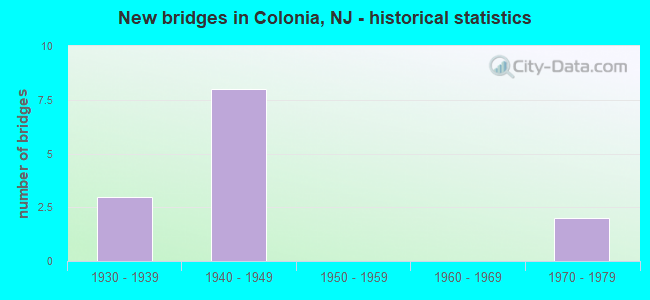
- New bridges - historical statistics
- 31930-1939
- 81940-1949
- 21970-1979

- Reconstructed bridges - Historical Statistics
- 21970-1979
- 11980-1989


- Bridge Condition - Deck
- 50.0%Satisfactory
- 50.0%Fair

- Bridge Condition - Superstructure
- 16.7%Good
- 50.0%Satisfactory
- 33.3%Fair

- Bridge Condition - Substructure
- 33.3%Good
- 50.0%Satisfactory
- 16.7%Fair

- Bridge Condition - Channel
- 50.0%Very good
- 50.0%Satisfactory
Find on map >> Show street view
Structure Number: 1218411, Location: 0.31 MI E OF COLONIA BLVD (Lat: 40.584269, Lng: -74.302961), Route carried "on" structure: County highway 650, Year Built: 1937, Year Reconstructed: 1992, Status: Open, Structure Length: 19.48m (63.91ft), Average Daily Traffic: 14,230 (year 2020), Truck Traffic: 3%, Average Future Daily Traffic: 19,200 (year 2040), Features Intersected: AMTRK NE COR &NJ27&MIDAV, Facility Carried by Structure: NEW DOVER ROAD
Minimum Vertical Clearance: 30+ m (98+ ft), Kilometerpoint: 2.832, Lanes on structure: 2, Lanes under structure: 5, Maintenance Responsibility: State Highway Agency, Approaching Roadway Width: 9.1m (29.9ft), Material/Design: Steel, Design/Construction: Girder and Floorbeam System, Number Of Spans In Main Unit: 3, Number Of Approach Spans: 11, Length of Maximum Span: 24.1m (79.1ft), Curb or Sidewalk Widths: Left: 1.5m (4.9ft), Right: 0.0m, Curb-To-Curb Width: 9.2m (30.2ft), Out-to-Out Width: 10.0m (32.8ft)
Condition: Deck: Satisfactory, Superstructure: Fair, Substructure: Fair, Operating Rating: 63.5 metric tons, Method Used To Determine Operating Rating: Load Factor (LF), Inventory Rating: 38.1 metric tons, Method Used To Determine Inventory Rating: Load Factor (LF), Structural Evaluation: Somewhat better than minimum adequacy, Deck Geometry: Meets minimum limits, Underclear: Meets minimum limits, Approach Roadway Alignment: Equal to present minimum criteria, Designated Inspection Frequency: Every 24 months, Critical Feature Inspection Frequency: Every 24 months, Inspection Date: November 2020, Critical Feature Inspection Date: November 2020, Deck Structure Type: Concrete Cast-file-Place, Wearing Surface/Protective System: Wearing Surface: Latex Concrete
Find on map >> Show street view
Structure Number: 121B037, Location: 1 MI. EAST OF GSP (Lat: 40.582569, Lng: -74.300181), Route carried "on" structure: City street , Year Built: 1977, Status: Open, Structure Length: 2.04m (6.69ft), Average Daily Traffic: 6,773 (year 2021), Truck Traffic: 3%, Average Future Daily Traffic: 8,127 (year 2041), Design Load: HS 20, Features Intersected: S.BRANCH OF RAHWAY RIVER, Facility Carried by Structure: NEW DOVER ROAD
Minimum Vertical Clearance: 30+ m (98+ ft), Kilometerpoint: 3.235, Lanes on structure: 2, Owner: County Highway Agency, Approaching Roadway Width: 13.4m (44.0ft), Material/Design: Prestressed concrete, Design/Construction: Box Beam or Girders - Multiple, Number Of Spans In Main Unit: 1, Length of Maximum Span: 19.2m (63.0ft), Curb or Sidewalk Widths: Left: 1.6m (5.2ft), Right: 1.6m (5.2ft), Curb-To-Curb Width: 13.4m (44.0ft), Out-to-Out Width: 17.2m (56.4ft)
Condition: Deck: Fair, Superstructure: Fair, Substructure: Satisfactory, Channel: Very good, Operating Rating: 28.1 metric tons, Method Used To Determine Operating Rating: Load Factor (LF), Inventory Rating: 16.3 metric tons, Method Used To Determine Inventory Rating: Load Factor (LF), Structural Evaluation: Meets minimum limits, Deck Geometry: Equal to present minimum criteria, Waterway Adequacy: Equal to present desirable criteria, Approach Roadway Alignment: Equal to present desirable criteria, Designated Inspection Frequency: Every 24 months, Inspection Date: April 2021, Deck Structure Type: Concrete Cast-file-Place, Wearing Surface/Protective System: Wearing Surface: Monolithic Concrete, Deck Protection: Epoxy Coated Reinforcing
Find on map >> Show street view
Structure Number: 122B244, Location: 0.5M S OF INMAN AVE (Lat: 40.595900, Lng: -74.327519), Route carried "on" structure: City street , Year Built: 1971, Status: Open, Structure Length: 0.76m (2.49ft), Average Daily Traffic: 362 (year 2021), Truck Traffic: 1%, Average Future Daily Traffic: 442 (year 2041), Features Intersected: PUMPKIN PATCH BROOK, Facility Carried by Structure: HAWTHORNE AVE
Minimum Vertical Clearance: 30+ m (98+ ft), Kilometerpoint: 0.000, Lanes on structure: 2, Owner: County Highway Agency, Approaching Roadway Width: 10.4m (34.1ft), Material/Design: Concrete, Design/Construction: Culvert, Number Of Spans In Main Unit: 3, Length of Maximum Span: 2.4m (7.9ft), Curb or Sidewalk Widths: Left: 1.2m (3.9ft), Right: 1.2m (3.9ft), Curb-To-Curb Width: 10.4m (34.1ft), Out-to-Out Width: 13.5m (44.3ft)
Condition: Channel: Satisfactory, Culverts: Good, Operating Rating: 44.5 metric tons, Method Used To Determine Operating Rating: Field evaluation and documented engineering judgment, Inventory Rating: 32.7 metric tons, Method Used To Determine Inventory Rating: Field evaluation and documented engineering judgment, Structural Evaluation: Better than present minimum criteria, Deck Geometry: Better than present minimum criteria, Waterway Adequacy: Equal to present desirable criteria, Approach Roadway Alignment: Better than present minimum criteria, Designated Inspection Frequency: Every 24 months, Inspection Date: June 2021
Find on map >> Show street view
Structure Number: 361330T, Location: 1.12 MI NORTH OF RT 27 (Lat: 40.585472, Lng: -74.328444), Route carried "on" structure: City street , Year Built: 1948, Status: Open, Structure Length: 7.28m (23.88ft), Average Daily Traffic: 9,018 (year 2021), Truck Traffic: 3%, Average Future Daily Traffic: 11,003 (year 2041), Design Load: H 20, Features Intersected: Garden State Parkway, Facility Carried by Structure: NEW DOVER ROAD
Minimum Vertical Clearance: 30+ m (98+ ft), Kilometerpoint: 4.538, Lanes on structure: 2, Lanes under structure: 10, Owner: State Toll Authority, Approaching Roadway Width: 11.0m (36.1ft), Material/Design: Concrete, Design/Construction: Frame, Number Of Spans In Main Unit: 2, Length of Maximum Span: 27.7m (90.9ft), Curb or Sidewalk Widths: Left: 1.7m (5.6ft), Right: 1.8m (5.9ft), Curb-To-Curb Width: 11.3m (37.1ft), Out-to-Out Width: 15.7m (51.5ft)
Condition: Superstructure: Satisfactory, Substructure: Satisfactory, Operating Rating: 67.4 metric tons, Method Used To Determine Operating Rating: Load and Resistance Factor Rating (LRFR) rating reported by rating factor(RF) method using HL-93 loadings, Inventory Rating: 52.2 metric tons, Method Used To Determine Inventory Rating: Load and Resistance Factor Rating (LRFR) rating reported by rating factor(RF) method using HL-93 loadings, Structural Evaluation: Equal to present minimum criteria, Deck Geometry: Meets minimum limits, Underclear: High priority of corrective action, Approach Roadway Alignment: Equal to present desirable criteria, Length Of Structure Improvement: 7.28m (23.88ft), Designated Inspection Frequency: Every 24 months, Inspection Date: June 2021, Bridge Improvement Cost: $4,522,000, Roadway Improvement Cost: $950,000, Total Project Cost: $7,551,000 ( Estimate for 2015)
Find on map >> Show street view
Structure Number: 361341T, Location: 2.23 MI NORTH OF RT 27 (Lat: 40.599444, Lng: -74.318753), Route carried "on" structure: County highway 602, Year Built: 1948, Status: Open, Structure Length: 8.66m (28.41ft), Average Daily Traffic: 18,463 (year 2021), Truck Traffic: 4%, Average Future Daily Traffic: 22,528 (year 2041), Design Load: HS 20, Features Intersected: GSP
Minimum Vertical Clearance: 30+ m (98+ ft), Kilometerpoint: 8.884, Lanes on structure: 2, Lanes under structure: 10, Owner: State Toll Authority, Approaching Roadway Width: 12.2m (40.0ft), Skew: 3 degrees, Material/Design: Concrete, Design/Construction: Frame, Number Of Spans In Main Unit: 2, Length of Maximum Span: 33.8m (110.9ft), Curb or Sidewalk Widths: Left: 1.8m (5.9ft), Right: 1.8m (5.9ft), Curb-To-Curb Width: 12.3m (40.4ft), Out-to-Out Width: 16.8m (55.1ft)
Condition: Superstructure: Satisfactory, Substructure: Satisfactory, Operating Rating: 46.7 metric tons, Method Used To Determine Operating Rating: Load and Resistance Factor Rating (LRFR) rating reported by rating factor(RF) method using HL-93 loadings, Inventory Rating: 36.0 metric tons, Method Used To Determine Inventory Rating: Load and Resistance Factor Rating (LRFR) rating reported by rating factor(RF) method using HL-93 loadings, Structural Evaluation: Equal to present minimum criteria, Deck Geometry: Somewhat better than minimum adequacy, Underclear: High priority of corrective action, Approach Roadway Alignment: Equal to present desirable criteria, Length Of Structure Improvement: 0.49m (1.61ft), Designated Inspection Frequency: Every 24 months, Inspection Date: June 2021, Bridge Improvement Cost: $36,000, Roadway Improvement Cost: $8,000, Total Project Cost: $60,000 ( Estimate for 2015)
Find on map >> Show street view
Structure Number: 361346N, Location: 2.7 MI N OF RT 27 (Lat: 40.606111, Lng: -74.313567), Route carried "on" structure: Other road GSP, Year Built: 1948, Year Reconstructed: 1976, Status: Open, Structure Length: 1.68m (5.51ft), Average Daily Traffic: 123,553 (year 2021), Truck Traffic: 1%, Average Future Daily Traffic: 150,760 (year 2041), Design Load: HS 20, Features Intersected: LAKE AVENUE
Minimum Vertical Clearance: 30+ m (98+ ft), Kilometerpoint: 216.795, Lanes on structure: 5, Lanes under structure: 2, Base Highway Network: Yes, Toll: On toll road, Owner: State Toll Authority, Approaching Roadway Width: 21.3m (69.9ft), Skew: 3 degrees, Material/Design: Concrete, Design/Construction: Frame, Number Of Spans In Main Unit: 1, Length of Maximum Span: 16.8m (55.1ft), Curb-To-Curb Width: 19.5m (64.0ft), Out-to-Out Width: 21.3m (69.9ft)
Condition: Superstructure: Satisfactory, Substructure: Good, Operating Rating: 58.0 metric tons, Method Used To Determine Operating Rating: Load and Resistance Factor Rating (LRFR) rating reported by rating factor(RF) method using HL-93 loadings, Inventory Rating: 44.7 metric tons, Method Used To Determine Inventory Rating: Load and Resistance Factor Rating (LRFR) rating reported by rating factor(RF) method using HL-93 loadings, Structural Evaluation: Equal to present minimum criteria, Deck Geometry: High priority of replacement, Underclear: Equal to present minimum criteria, Approach Roadway Alignment: Equal to present desirable criteria, Length Of Structure Improvement: 1.71m (5.61ft), Designated Inspection Frequency: Every 24 months, Inspection Date: June 2021, Bridge Improvement Cost: $1,473,000, Roadway Improvement Cost: $308,000, Total Project Cost: $2,460,000 ( Estimate for 2015)
Find on map >> Show street view
Structure Number: 361346S, Location: 2.7 MI N OF RT 27 (Lat: 40.605867, Lng: -74.314544), Route carried "on" structure: Other road GSP, Year Built: 1948, Year Reconstructed: 1976, Status: Open, Structure Length: 1.71m (5.61ft), Average Daily Traffic: 152,790 (year 2021), Truck Traffic: 1%, Average Future Daily Traffic: 186,433 (year 2041), Design Load: HS 20, Features Intersected: LAKE AVENUE
Minimum Vertical Clearance: 30+ m (98+ ft), Kilometerpoint: 216.795, Lanes on structure: 5, Lanes under structure: 2, Base Highway Network: Yes, Toll: On toll road, Owner: State Toll Authority, Approaching Roadway Width: 21.3m (69.9ft), Skew: 3 degrees, Material/Design: Concrete, Design/Construction: Frame, Number Of Spans In Main Unit: 1, Length of Maximum Span: 17.1m (56.1ft), Curb-To-Curb Width: 19.2m (63.0ft), Out-to-Out Width: 21.0m (68.9ft)
Condition: Superstructure: Good, Substructure: Good, Operating Rating: 58.0 metric tons, Method Used To Determine Operating Rating: Load and Resistance Factor Rating (LRFR) rating reported by rating factor(RF) method using HL-93 loadings, Inventory Rating: 44.7 metric tons, Method Used To Determine Inventory Rating: Load and Resistance Factor Rating (LRFR) rating reported by rating factor(RF) method using HL-93 loadings, Structural Evaluation: Better than present minimum criteria, Deck Geometry: High priority of replacement, Underclear: Equal to present minimum criteria, Approach Roadway Alignment: Equal to present desirable criteria, Length Of Structure Improvement: 1.71m (5.61ft), Designated Inspection Frequency: Every 24 months, Inspection Date: June 2021, Bridge Improvement Cost: $1,445,000, Roadway Improvement Cost: $304,000, Total Project Cost: $2,413,000 ( Estimate for 2015)
Find on map >> Show street view
Structure Number: 1218411, Location: 0.31 MI E OF COLONIA BLVD (Lat: 40.584269, Lng: -74.302961), Route carried "under" structure: City street , Year Built: 1937, Structure Length: 0. m, Average Daily Traffic: 3,430 (year 2020), Truck Traffic: 1%, Features Intersected: AMTRK NE COR &NJ27&MIDAV, Facility Carried by Structure: NEW DOVER ROAD
Minimum Vertical Clearance: 4.95m (16.24ft), Kilometerpoint: 0.000, Lanes on structure: 2, Lanes under structure: 2, Material/Design: Steel, Design/Construction: Girder and Floorbeam System, Length of Maximum Span: 24.1m (79.1ft)
Find on map >> Show street view
Structure Number: 1218411, Location: 0.31 MI E OF COLONIA BLVD (Lat: 40.584269, Lng: -74.302961), Route carried "under" structure: State highway 27, Year Built: 1937, Structure Length: 0. m, Average Daily Traffic: 24,150 (year 2020), Truck Traffic: 4%, Features Intersected: AMTRK NE COR &NJ27&MIDAV, Facility Carried by Structure: NEW DOVER ROAD
Minimum Vertical Clearance: 6.73m (22.08ft), Kilometerpoint: 42.326, Lanes on structure: 2, Lanes under structure: 3, Material/Design: Steel, Design/Construction: Girder and Floorbeam System, Length of Maximum Span: 24.1m (79.1ft)
Find on map >> Show street view
Structure Number: 361330T, Location: 1.12 MI NORTH OF RT 27 (Lat: 40.585472, Lng: -74.328444), Route carried "under" structure: Other road GSP, Year Built: 1948, Structure Length: 0. m, Average Daily Traffic: 278,186 (year 2021), Truck Traffic: 1%, Features Intersected: Garden State Parkway, Facility Carried by Structure: NEW DOVER ROAD
Minimum Vertical Clearance: 5.49m (18.01ft), Kilometerpoint: 214.172, Lanes on structure: 2, Lanes under structure: 10, Toll: On toll road, Material/Design: Concrete, Design/Construction: Frame, Length of Maximum Span: 27.7m (90.9ft)
Find on map >> Show street view
Structure Number: 361341T, Location: 2.23 MI NORTH OF RT 27 (Lat: 40.599444, Lng: -74.318753), Route carried "under" structure: Other road GSP, Year Built: 1948, Structure Length: 0. m, Average Daily Traffic: 285,159 (year 2021), Truck Traffic: 1%, Features Intersected: GSP, Facility Carried by Structure: INMAN AVE (CR 602)
Minimum Vertical Clearance: 5.56m (18.24ft), Kilometerpoint: 215.974, Lanes on structure: 2, Lanes under structure: 10, Toll: On toll road, Material/Design: Concrete, Design/Construction: Frame, Length of Maximum Span: 33.8m (110.9ft)
Find on map >> Show street view
Structure Number: 361346N, Location: 2.7 MI N OF RT 27 (Lat: 40.606111, Lng: -74.313567), Route carried "under" structure: City street , Year Built: 1948, Structure Length: 0. m, Average Daily Traffic: 21,106 (year 2021), Truck Traffic: 4%, Features Intersected: LAKE AVENUE, Facility Carried by Structure: GSP NORTHBOUND
Minimum Vertical Clearance: 4.64m (15.22ft), Kilometerpoint: 0.869, Lanes on structure: 5, Lanes under structure: 2, Material/Design: Concrete, Design/Construction: Frame, Length of Maximum Span: 16.8m (55.1ft)
Find on map >> Show street view
Structure Number: 361346S, Location: 2.7 MI N OF RT 27 (Lat: 40.605867, Lng: -74.314544), Route carried "under" structure: City street , Year Built: 1948, Structure Length: 0. m, Average Daily Traffic: 21,106 (year 2021), Truck Traffic: 4%, Features Intersected: LAKE AVENUE, Facility Carried by Structure: GSP SOUTHBOUND
Minimum Vertical Clearance: 4.97m (16.31ft), Kilometerpoint: 0.821, Lanes on structure: 5, Lanes under structure: 2, Material/Design: Concrete, Design/Construction: Frame, Length of Maximum Span: 17.1m (56.1ft)