Bridge Statistics for College Park, Maryland (MD)
Condition, Traffic, Stress, Structural Evaluation, Project Costs
- National Bridge Inventory (NBI) Statistics
- 18Number of bridges
- 177ft / 54.0mTotal length
- $6,160,000Total costs
- 1,074,503Total average daily traffic
- 62,004Total average daily truck traffic
- National Bridge Inventory (NBI) Registered Bridges for College Park
- No street view available for this location
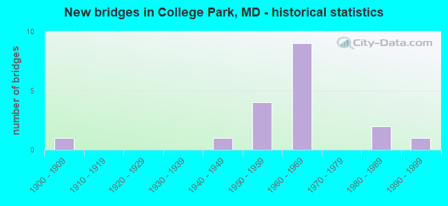
- New bridges - historical statistics
- 11900-1909
- 11940-1949
- 41950-1959
- 91960-1969
- 21980-1989
- 11990-1999

- Reconstructed bridges - Historical Statistics
- 11960-1969
- 21970-1979
- 31980-1989


- Bridge Condition - Deck
- 27.3%Good
- 36.4%Satisfactory
- 27.3%Fair
- 9.1%Poor

- Bridge Condition - Superstructure
- 9.1%Good
- 45.5%Satisfactory
- 27.3%Fair
- 18.2%Poor

- Bridge Condition - Substructure
- 36.4%Good
- 18.2%Satisfactory
- 45.5%Fair

- Bridge Condition - Channel
- 33.3%Very good
- 22.2%Good
- 44.4%Satisfactory

- Bridge Condition - Culverts
- 33.3%Very good
- 33.3%Satisfactory
- 33.3%Fair
Find on map >> Show street view
Structure Number: 10000016000301, Location: 0.21 MILE NORTH OF MD 430 (Lat: 39.001311, Lng: -76.931108), Route carried "on" structure: US 1, Year Built: 1988, Status: Open, Structure Length: 3.84m (12.60ft), Average Daily Traffic: 47,562 (year 2009), Truck Traffic: 8%, Average Future Daily Traffic: 57,479 (year 2026), Design Load: HS 20+Mod, Features Intersected: MD 193
Minimum Vertical Clearance: 30+ m (98+ ft), Kilometerpoint: 8.431, Lanes on structure: 5, Lanes under structure: 4, Base Highway Network: Yes, Owner: State Highway Agency, Approaching Roadway Width: 19.8m (65.0ft), Skew: 1 degrees, Material/Design: Steel continuous, Design/Construction: Stringer/Multi-beam, Number Of Spans In Main Unit: 2, Length of Maximum Span: 19.2m (63.0ft), Curb or Sidewalk Widths: Left: 1.6m (5.2ft), Right: 1.6m (5.2ft), Curb-To-Curb Width: 19.8m (65.0ft), Out-to-Out Width: 23.5m (77.1ft)
Condition: Deck: Good, Superstructure: Good, Substructure: Good, Operating Rating: 74.4 metric tons, Method Used To Determine Operating Rating: Load Factor (LF), Inventory Rating: 44.9 metric tons, Method Used To Determine Inventory Rating: Load Factor (LF), Structural Evaluation: Better than present minimum criteria, Deck Geometry: Meets minimum limits, Underclear: Equal to present minimum criteria, Approach Roadway Alignment: Equal to present desirable criteria, Designated Inspection Frequency: Every 24 months, Inspection Date: August 2021, Deck Structure Type: Concrete Cast-file-Place, Wearing Surface/Protective System: Wearing Surface: Monolithic Concrete, Deck Protection: Epoxy Coated Reinforcing
Find on map >> Show street view
Structure Number: 10000016001801, Location: 0.37 MILE WEST OF MD 193B (Lat: 38.984753, Lng: -76.964408), Route carried "on" structure: State highway 193, Year Built: 1956, Year Reconstructed: 1992, Status: Open, Structure Length: 4.05m (13.29ft), Average Daily Traffic: 29,880 (year 2009), Truck Traffic: 3%, Average Future Daily Traffic: 39,548 (year 2026), Design Load: HS 20+Mod, Features Intersected: NORTHWEST BRANCH
Minimum Vertical Clearance: 30+ m (98+ ft), Kilometerpoint: 2.800, Lanes on structure: 4, Base Highway Network: Yes, Owner: State Highway Agency, Approaching Roadway Width: 26.8m (87.9ft), Skew: 20 degrees, Material/Design: Steel continuous, Design/Construction: Stringer/Multi-beam, Number Of Spans In Main Unit: 3, Length of Maximum Span: 15.2m (49.9ft), Curb or Sidewalk Widths: Left: 1.5m (4.9ft), Right: 1.5m (4.9ft), Curb-To-Curb Width: 22.0m (72.2ft), Out-to-Out Width: 30.6m (100.4ft)
Condition: Deck: Good, Superstructure: Satisfactory, Substructure: Good, Channel: Satisfactory, Operating Rating: 60.3 metric tons, Method Used To Determine Operating Rating: Load Factor (LF), Inventory Rating: 36.3 metric tons, Method Used To Determine Inventory Rating: Load Factor (LF), Structural Evaluation: Equal to present minimum criteria, Deck Geometry: Superior to present desirable criteria, Waterway Adequacy: Equal to present desirable criteria, Approach Roadway Alignment: Equal to present desirable criteria, Designated Inspection Frequency: Every 24 months, Inspection Date: October 2020, Deck Structure Type: Concrete Cast-file-Place, Wearing Surface/Protective System: Wearing Surface: Integral Concrete, Deck Protection: Epoxy Coated Reinforcing
Find on map >> Show street view
Structure Number: 10000016001901, Location: 0.15 MILE WEST OF US 1 (Lat: 39.001306, Lng: -76.933947), Route carried "on" structure: State highway 193, Year Built: 1955, Year Reconstructed: 1983, Status: Open, Structure Length: 3.47m (11.38ft), Average Daily Traffic: 41,260 (year 2009), Truck Traffic: 8%, Average Future Daily Traffic: 53,937 (year 2026), Design Load: HS 20, Features Intersected: PAINT BRANCH
Minimum Vertical Clearance: 30+ m (98+ ft), Kilometerpoint: 6.346, Lanes on structure: 4, Base Highway Network: Yes, Owner: State Highway Agency, Approaching Roadway Width: 28.7m (94.2ft), Material/Design: Steel, Design/Construction: Stringer/Multi-beam, Number Of Spans In Main Unit: 1, Number Of Approach Spans: 2, Length of Maximum Span: 15.2m (49.9ft), Curb-To-Curb Width: 25.1m (82.3ft), Out-to-Out Width: 26.5m (86.9ft)
Condition: Deck: Good, Superstructure: Satisfactory, Substructure: Fair, Channel: Very good, Operating Rating: 68.9 metric tons, Method Used To Determine Operating Rating: Load Factor (LF), Inventory Rating: 41.3 metric tons, Method Used To Determine Inventory Rating: Load Factor (LF), Structural Evaluation: Somewhat better than minimum adequacy, Deck Geometry: Superior to present desirable criteria, Waterway Adequacy: Superior to present desirable criteria, Approach Roadway Alignment: Equal to present desirable criteria, Designated Inspection Frequency: Every 24 months, Inspection Date: October 2020, Deck Structure Type: Other
Find on map >> Show street view
Structure Number: 10000016007001, Location: 0.12 MILE EAST OF MD 430 (Lat: 38.998208, Lng: -76.919806), Route carried "on" structure: State highway 193, Year Built: 1942, Year Reconstructed: 1988, Status: Open, Structure Length: 7.53m (24.70ft), Average Daily Traffic: 49,911 (year 2019), Truck Traffic: 8%, Average Future Daily Traffic: 69,140 (year 2039), Design Load: HS 20, Features Intersected: CSXT, METRO, 55TH AVENUE
Minimum Vertical Clearance: 30+ m (98+ ft), Kilometerpoint: 7.627, Lanes on structure: 6, Lanes under structure: 1, Base Highway Network: Yes, Owner: State Highway Agency, Approaching Roadway Width: 21.9m (71.9ft), Skew: 31 degrees, Material/Design: Steel, Design/Construction: Stringer/Multi-beam, Number Of Spans In Main Unit: 4, Length of Maximum Span: 22.3m (73.2ft), Curb or Sidewalk Widths: Left: 1.5m (4.9ft), Right: 1.3m (4.3ft), Curb-To-Curb Width: 20.7m (67.9ft), Out-to-Out Width: 25.4m (83.3ft)
Condition: Deck: Fair, Superstructure: Fair, Substructure: Satisfactory, Operating Rating: 84.4 metric tons, Method Used To Determine Operating Rating: Load Factor (LF), Inventory Rating: 50.8 metric tons, Method Used To Determine Inventory Rating: Load Factor (LF), Structural Evaluation: Somewhat better than minimum adequacy, Deck Geometry: High priority of replacement, Underclear: Equal to present minimum criteria, Approach Roadway Alignment: Equal to present desirable criteria, Length Of Structure Improvement: 7.53m (24.70ft), Designated Inspection Frequency: Every 24 months, Inspection Date: October 2020, Bridge Improvement Cost: $1,235,000, Roadway Improvement Cost: $124,000, Total Project Cost: $1,363,000, Deck Structure Type: Concrete Cast-file-Place, Wearing Surface/Protective System: Wearing Surface: Bituminous
Find on map >> Show street view
Structure Number: 10000016007603, Location: AT MD 430 (Lat: 38.998078, Lng: -76.922331), Route carried "on" structure: State highway 193, Year Built: 1962, Status: Open, Structure Length: 5.91m (19.39ft), Average Daily Traffic: 45,930 (year 0009), Truck Traffic: 8%, Average Future Daily Traffic: 60,590 (year 0026), Design Load: HS 20, Features Intersected: BRANCH OF INDIAN CREEK
Minimum Vertical Clearance: 30+ m (98+ ft), Kilometerpoint: 7.446, Lanes on structure: 6, Base Highway Network: Yes, Owner: State Highway Agency, Approaching Roadway Width: 20.7m (67.9ft), Skew: 1 degrees, Material/Design: Steel, Design/Construction: Culvert, Length of Maximum Span: 3.0m (9.8ft)
Condition: Channel: Very good, Culverts: Fair, Structural Evaluation: Somewhat better than minimum adequacy, Waterway Adequacy: Superior to present desirable criteria, Approach Roadway Alignment: Equal to present desirable criteria, Designated Inspection Frequency: Every 24 months, Inspection Date: Febuary 2020
Find on map >> Show street view
Structure Number: 10000016013401, Location: 1.19 MILE NORTH OF MD 193 (Lat: 39.017878, Lng: -76.926594), Route carried "on" structure: US 1, Year Built: 1963, Year Reconstructed: 1971, Status: Open, Structure Length: 8.53m (27.99ft), Average Daily Traffic: 48,232 (year 2009), Truck Traffic: 8%, Average Future Daily Traffic: 58,794 (year 2038), Design Load: HS 20, Features Intersected: IS 95
Minimum Vertical Clearance: 30+ m (98+ ft), Kilometerpoint: 10.346, Lanes on structure: 6, Lanes under structure: 8, Base Highway Network: Yes, Owner: State Highway Agency, Approaching Roadway Width: 25.0m (82.0ft), Skew: 20 degrees, Material/Design: Steel continuous, Design/Construction: Stringer/Multi-beam, Number Of Spans In Main Unit: 2, Number Of Approach Spans: 3, Length of Maximum Span: 25.6m (84.0ft), Curb or Sidewalk Widths: Left: 1.6m (5.2ft), Right: 1.6m (5.2ft), Curb-To-Curb Width: 25.0m (82.0ft), Out-to-Out Width: 28.7m (94.2ft)
Condition: Deck: Satisfactory, Superstructure: Fair, Substructure: Good, Operating Rating: 72.1 metric tons, Method Used To Determine Operating Rating: Load Factor (LF), Inventory Rating: 43.1 metric tons, Method Used To Determine Inventory Rating: Load Factor (LF), Structural Evaluation: Somewhat better than minimum adequacy, Deck Geometry: Somewhat better than minimum adequacy, Underclear: Somewhat better than minimum adequacy, Approach Roadway Alignment: Equal to present desirable criteria, Designated Inspection Frequency: Every 24 months, Inspection Date: October 2020, Deck Structure Type: Concrete Cast-file-Place, Wearing Surface/Protective System: Wearing Surface: Bituminous
Find on map >> Show street view
Structure Number: 100000160135015, Location: 0.34 MILE SOUTH OF US 1 (Lat: 39.018619, Lng: -76.919908), Route carried "on" structure: Interstate 95, Year Built: 1963, Status: Open, Structure Length: 3.78m (12.40ft), Average Daily Traffic: 215,560 (year 2009), Truck Traffic: 8%, Average Future Daily Traffic: 119,466 (year 2026), Design Load: HS 20, Features Intersected: RHODE ISLAND AVENUE
Minimum Vertical Clearance: 30+ m (98+ ft), Kilometerpoint: 39.966, Lanes on structure: 4, Lanes under structure: 2, Base Highway Network: Yes, Owner: State Highway Agency, Approaching Roadway Width: 21.9m (71.9ft), Skew: 1 degrees, Material/Design: Steel, Design/Construction: Stringer/Multi-beam, Number Of Spans In Main Unit: 3, Length of Maximum Span: 15.9m (52.2ft), Curb-To-Curb Width: 20.7m (67.9ft), Out-to-Out Width: 21.3m (69.9ft)
Condition: Deck: Satisfactory, Superstructure: Satisfactory, Substructure: Satisfactory, Operating Rating: 71.7 metric tons, Method Used To Determine Operating Rating: Load Factor (LF), Inventory Rating: 43.1 metric tons, Method Used To Determine Inventory Rating: Load Factor (LF), Structural Evaluation: Equal to present minimum criteria, Deck Geometry: Equal to present minimum criteria, Underclear: Equal to present minimum criteria, Approach Roadway Alignment: Equal to present desirable criteria, Length Of Structure Improvement: 3.78m (12.40ft), Designated Inspection Frequency: Every 24 months, Inspection Date: Febuary 2020, Bridge Improvement Cost: $1,042,000, Roadway Improvement Cost: $104,000, Total Project Cost: $1,146,000, Deck Structure Type: Concrete Cast-file-Place, Wearing Surface/Protective System: Wearing Surface: Bituminous
Find on map >> Show street view
Structure Number: 100000160135016, Location: 0.34 MILE SOUTH OF US 1 (Lat: 39.018364, Lng: -76.920406), Route carried "on" structure: Interstate 95, Year Built: 1963, Status: Open, Structure Length: 3.78m (12.40ft), Average Daily Traffic: 215,560 (year 2009), Truck Traffic: 8%, Average Future Daily Traffic: 119,466 (year 2026), Design Load: HS 20, Features Intersected: RHODE ISLAND AVENUE
Minimum Vertical Clearance: 30+ m (98+ ft), Kilometerpoint: 39.966, Lanes on structure: 4, Lanes under structure: 2, Base Highway Network: Yes, Owner: State Highway Agency, Approaching Roadway Width: 21.9m (71.9ft), Skew: 1 degrees, Material/Design: Steel, Design/Construction: Stringer/Multi-beam, Number Of Spans In Main Unit: 3, Length of Maximum Span: 15.9m (52.2ft), Curb-To-Curb Width: 20.7m (67.9ft), Out-to-Out Width: 21.3m (69.9ft)
Condition: Deck: Satisfactory, Superstructure: Satisfactory, Substructure: Good, Operating Rating: 62.6 metric tons, Method Used To Determine Operating Rating: Load Factor (LF), Inventory Rating: 37.6 metric tons, Method Used To Determine Inventory Rating: Load Factor (LF), Structural Evaluation: Equal to present minimum criteria, Deck Geometry: Equal to present minimum criteria, Underclear: Equal to present minimum criteria, Approach Roadway Alignment: Equal to present desirable criteria, Length Of Structure Improvement: 3.78m (12.40ft), Designated Inspection Frequency: Every 24 months, Inspection Date: Febuary 2020, Bridge Improvement Cost: $1,042,000, Roadway Improvement Cost: $104,000, Total Project Cost: $1,146,000, Deck Structure Type: Concrete Cast-file-Place, Wearing Surface/Protective System: Wearing Surface: Bituminous
Find on map >> Show street view
Structure Number: 10000016025603, Location: 0.27 MILE WEST OF US 1 (Lat: 39.001197, Lng: -76.936081), Route carried "on" structure: State highway 193, Year Built: 1955, Status: Open, Structure Length: 0.70m (2.30ft), Average Daily Traffic: 41,260 (year 2009), Truck Traffic: 8%, Average Future Daily Traffic: 53,937 (year 2026), Features Intersected: TRIB TO PAINT BRANCH
Minimum Vertical Clearance: 30+ m (98+ ft), Kilometerpoint: 6.154, Lanes on structure: 4, Base Highway Network: Yes, Owner: State Highway Agency, Approaching Roadway Width: 36.6m (120.1ft), Material/Design: Steel, Design/Construction: Culvert, Length of Maximum Span: 1.5m (4.9ft)
Condition: Channel: Very good, Culverts: Very good, Structural Evaluation: Equal to present desirable criteria, Waterway Adequacy: Better than present minimum criteria, Approach Roadway Alignment: Equal to present desirable criteria, Designated Inspection Frequency: Every 24 months, Inspection Date: October 2021
Find on map >> Show street view
Structure Number: 200000P-010401, Location: 0.5 MILES WEST OF US 1 (Lat: 39.017419, Lng: -76.934867), Route carried "on" structure: County highway 14, Year Built: 1966, Status: Posted for load, Structure Length: 3.35m (10.99ft), Average Daily Traffic: 22,300 (year 2017), Truck Traffic: 5%, Average Future Daily Traffic: 33,130 (year 2037), Design Load: H 20, Features Intersected: LITTLE PAINT BRANCH, Facility Carried by Structure: CHERRY HILL ROAD
Minimum Vertical Clearance: 30+ m (98+ ft), Kilometerpoint: 0.708, Lanes on structure: 2, Owner: County Highway Agency, Approaching Roadway Width: 18.3m (60.0ft), Material/Design: Prestressed concrete, Design/Construction: Slab, Number Of Spans In Main Unit: 3, Length of Maximum Span: 10.7m (35.1ft), Curb or Sidewalk Widths: Left: 0.6m (2.0ft), Right: 1.2m (3.9ft), Curb-To-Curb Width: 13.4m (44.0ft), Out-to-Out Width: 15.9m (52.2ft)
Condition: Deck: Poor, Superstructure: Poor, Substructure: Fair, Channel: Satisfactory, Operating Rating: 56.7 metric tons, Method Used To Determine Operating Rating: Load Factor (LF), Inventory Rating: 34.0 metric tons, Method Used To Determine Inventory Rating: Load Factor (LF), Structural Evaluation: Meets minimum limits, Deck Geometry: Equal to present minimum criteria, Waterway Adequacy: Equal to present minimum criteria, Approach Roadway Alignment: Equal to present desirable criteria, Bridge Posting: Required (Relationship of Operating Rating to Maximum Legal Load: 0.1 - 9.9% below), Length Of Structure Improvement: 4.27m (14.01ft), Designated Inspection Frequency: Every 12 months, Inspection Date: Febuary 2021, Bridge Improvement Cost: $1,400,000, Roadway Improvement Cost: $140,000, Total Project Cost: $2,100,000, Deck Structure Type: Concrete Precast Panels, Wearing Surface/Protective System: Wearing Surface: Bituminous
Find on map >> Show street view
Structure Number: 200000P-010601, Location: 0.33 MI W OF MD 201 (Lat: 38.975308, Lng: -76.919836), Route carried "on" structure: County highway 3642, Year Built: 1964, Year Reconstructed: 1994, Status: Posted for load, Structure Length: 4.27m (14.01ft), Average Daily Traffic: 13,990 (year 2019), Truck Traffic: 10%, Average Future Daily Traffic: 20,790 (year 2039), Design Load: H 20, Features Intersected: NORTHEAST BRANCH, Facility Carried by Structure: CAMPUS DRIVE
Minimum Vertical Clearance: 30+ m (98+ ft), Kilometerpoint: 1.689, Lanes on structure: 4, Owner: County Highway Agency, Approaching Roadway Width: 17.7m (58.1ft), Skew: 3 degrees, Material/Design: Steel, Design/Construction: Stringer/Multi-beam, Number Of Spans In Main Unit: 3, Length of Maximum Span: 13.7m (44.9ft), Curb or Sidewalk Widths: Left: 1.2m (3.9ft), Right: 2.6m (8.5ft), Curb-To-Curb Width: 17.7m (58.1ft), Out-to-Out Width: 22.2m (72.8ft)
Condition: Deck: Fair, Superstructure: Poor, Substructure: Fair, Channel: Satisfactory, Operating Rating: 66.2 metric tons, Method Used To Determine Operating Rating: Load Factor (LF), Inventory Rating: 39.5 metric tons, Method Used To Determine Inventory Rating: Load Factor (LF), Structural Evaluation: Meets minimum limits, Deck Geometry: Somewhat better than minimum adequacy, Waterway Adequacy: Better than present minimum criteria, Approach Roadway Alignment: Equal to present desirable criteria, Designated Inspection Frequency: Every 24 months, Inspection Date: June 2021, Deck Structure Type: Concrete Cast-file-Place, Wearing Surface/Protective System: Wearing Surface: Bituminous
Find on map >> Show street view
Structure Number: 200000P-011601, Location: .1 MI S OF PAINT BR PKWY (Lat: 38.976942, Lng: -76.927067), Route carried "on" structure: County highway 5409, Year Built: 1995, Status: Open, Structure Length: 1.04m (3.41ft), Average Daily Traffic: 13,540 (year 2017), Truck Traffic: 5%, Average Future Daily Traffic: 20,120 (year 2037), Design Load: HS 20, Features Intersected: TRIB TO PAINT BRANCH, Facility Carried by Structure: RIVER ROAD
Minimum Vertical Clearance: 30+ m (98+ ft), Kilometerpoint: 0.161, Lanes on structure: 5, Owner: State Highway Agency, Approaching Roadway Width: 18.3m (60.0ft), Skew: 22 degrees, Material/Design: Concrete, Design/Construction: Culvert, Number Of Spans In Main Unit: 3, Length of Maximum Span: 3.4m (11.2ft), Curb or Sidewalk Widths: Left: 2.6m (8.5ft), Right: 6.1m (20.0ft)
Condition: Channel: Good, Culverts: Satisfactory, Operating Rating: 78.0 metric tons, Method Used To Determine Operating Rating: Load Factor (LF), Inventory Rating: 46.7 metric tons, Method Used To Determine Inventory Rating: Load Factor (LF), Structural Evaluation: Equal to present minimum criteria, Waterway Adequacy: Better than present minimum criteria, Approach Roadway Alignment: Equal to present desirable criteria, Designated Inspection Frequency: Every 24 months, Inspection Date: March 2021
Find on map >> Show street view
Structure Number: 200000P-018501, Location: 0.03 MI W OF US 1 (Lat: 38.998556, Lng: -76.932333), Route carried "on" structure: County highway 231, Year Built: 1900, Year Reconstructed: 1970, Status: Open, Structure Length: 1.89m (6.20ft), Average Daily Traffic: 14,850 (year 2017), Truck Traffic: 10%, Average Future Daily Traffic: 22,070 (year 2037), Features Intersected: PAINT BRANCH, Facility Carried by Structure: METZEROTT ROAD
Minimum Vertical Clearance: 30+ m (98+ ft), Kilometerpoint: 0.048, Lanes on structure: 1, Owner: County Highway Agency, Approaching Roadway Width: 7.0m (23.0ft), Material/Design: Steel, Design/Construction: Stringer/Multi-beam, Number Of Spans In Main Unit: 1, Length of Maximum Span: 17.1m (56.1ft), Curb or Sidewalk Widths: Left: 1.3m (4.3ft), Right: 0.0m, Curb-To-Curb Width: 4.3m (14.1ft), Out-to-Out Width: 5.9m (19.4ft)
Condition: Deck: Fair, Superstructure: Fair, Substructure: Fair, Channel: Satisfactory, Operating Rating: 71.2 metric tons, Method Used To Determine Operating Rating: Load Factor (LF), Inventory Rating: 42.6 metric tons, Method Used To Determine Inventory Rating: Load Factor (LF), Structural Evaluation: Somewhat better than minimum adequacy, Deck Geometry: High priority of replacement, Waterway Adequacy: Better than present minimum criteria, Approach Roadway Alignment: High priority of corrective action, Length Of Structure Improvement: 1.77m (5.81ft), Designated Inspection Frequency: Every 24 months, Inspection Date: Febuary 2021, Bridge Improvement Cost: $204,000, Roadway Improvement Cost: $21,000, Total Project Cost: $225,000, Deck Structure Type: Concrete Cast-file-Place
Find on map >> Show street view
Structure Number: 2001001P, Location: CAPITAL BELTWAY TO EXIT 2 (Lat: 39.015194, Lng: -76.943333), Route carried "on" structure: Federal lands road 60, Year Built: 1955, Status: Open, Structure Length: 1.89m (6.20ft), Average Daily Traffic: 400 (year 2005), Truck Traffic: 4%, Average Future Daily Traffic: 440 (year 2025), Design Load: H 15, Features Intersected: PAINT BRANCH, Facility Carried by Structure: SOUTH FARM ROAD
Minimum Vertical Clearance: 30+ m (98+ ft), Kilometerpoint: 0.000, Lanes on structure: 2, Owner: USDA/ARS, Approaching Roadway Width: 6.7m (22.0ft), Material/Design: Steel, Design/Construction: Stringer/Multi-beam, Number Of Spans In Main Unit: 1, Length of Maximum Span: 18.3m (60.0ft), Curb or Sidewalk Widths: Left: 0.5m (1.6ft), Right: 0.5m (1.6ft), Curb-To-Curb Width: 7.3m (24.0ft), Out-to-Out Width: 8.9m (29.2ft)
Condition: Deck: Satisfactory, Superstructure: Satisfactory, Substructure: Fair, Channel: Good, Operating Rating: 34.5 metric tons, Method Used To Determine Operating Rating: Load Factor (LF), Inventory Rating: 20.9 metric tons, Method Used To Determine Inventory Rating: Load Factor (LF), Structural Evaluation: Somewhat better than minimum adequacy, Deck Geometry: Somewhat better than minimum adequacy, Waterway Adequacy: Equal to present desirable criteria, Approach Roadway Alignment: Equal to present desirable criteria, Designated Inspection Frequency: Every 24 months, Inspection Date: August 2019, Bridge Improvement Cost: $120,000, Roadway Improvement Cost: $12,000, Total Project Cost: $180,000 ( Estimate for 2019), Deck Structure Type: Concrete Cast-file-Place
Find on map >> Show street view
Structure Number: 10000016000301, Location: 0.53 MILE WEST OF MD 430 (Lat: 39.001311, Lng: -76.931108), Route carried "under" structure: State highway 193, Year Built: 1988, Structure Length: 0. m, Average Daily Traffic: 45,930 (year 2009), Features Intersected: MD 193, Facility Carried by Structure: US 1
Minimum Vertical Clearance: 4.88m (16.01ft), Kilometerpoint: 6.581, Lanes on structure: 5, Lanes under structure: 4, Material/Design: Steel continuous, Design/Construction: Stringer/Multi-beam, Length of Maximum Span: 19.2m (63.0ft)
Find on map >> Show street view
Structure Number: 10000016013401, Location: 0.92 MILE SOUTH OF IS 495 (Lat: 39.017878, Lng: -76.926594), Route carried "under" structure: Interstate 95, Year Built: 1963, Structure Length: 0. m, Average Daily Traffic: 226,340 (year 2009), Features Intersected: IS 95, Facility Carried by Structure: US 1
Minimum Vertical Clearance: 10.06m (33.01ft), Kilometerpoint: 40.531, Lanes on structure: 6, Lanes under structure: 8, Material/Design: Steel continuous, Design/Construction: Stringer/Multi-beam, Length of Maximum Span: 25.6m (84.0ft)
Find on map >> Show street view
Structure Number: 100000160135015, Location: 0.34 MI S OF US 1 (Lat: 39.018619, Lng: -76.919908), Route carried "under" structure: County highway 1291, Year Built: 1963, Structure Length: 0. m, Average Daily Traffic: 999 (year 2012), Features Intersected: RHODE ISLAND AVENUE, Facility Carried by Structure: IS 95 IL
Minimum Vertical Clearance: 5.49m (18.01ft), Kilometerpoint: 2.590, Lanes on structure: 4, Lanes under structure: 2, Material/Design: Steel, Design/Construction: Stringer/Multi-beam, Length of Maximum Span: 15.9m (52.2ft)
Find on map >> Show street view
Structure Number: 100000160135016, Location: 0.34 MI S OF US 1 (Lat: 39.018364, Lng: -76.920406), Route carried "under" structure: County highway 1291, Year Built: 1963, Structure Length: 0. m, Average Daily Traffic: 999 (year 2012), Features Intersected: RHODE ISLAND AVENUE, Facility Carried by Structure: IS 95 OL
Minimum Vertical Clearance: 5.49m (18.01ft), Kilometerpoint: 2.590, Lanes on structure: 4, Lanes under structure: 2, Material/Design: Steel, Design/Construction: Stringer/Multi-beam, Length of Maximum Span: 15.9m (52.2ft)