Bridge Statistics for Colesville, Maryland (MD)
Condition, Traffic, Stress, Structural Evaluation, Project Costs
- National Bridge Inventory (NBI) Statistics
- 15Number of bridges
- 1,125ft / 343mTotal length
- $26,000Total costs
- 385,596Total average daily traffic
- 16,714Total average daily truck traffic
- 599,428Total future (year 2031) average daily traffic
- National Bridge Inventory (NBI) Registered Bridges for Colesville
- No street view available for this location
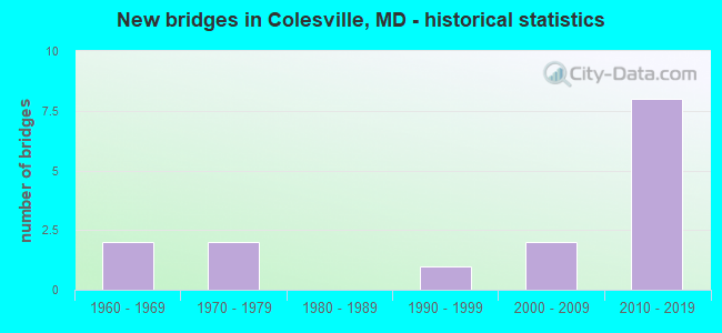
- New bridges - historical statistics
- 21960-1969
- 21970-1979
- 11990-1999
- 22000-2009
- 82010-2019


- Bridge Condition - Deck
- 90.0%Good
- 10.0%Fair

- Bridge Condition - Superstructure
- 20.0%Very good
- 80.0%Good

- Bridge Condition - Substructure
- 50.0%Very good
- 40.0%Good
- 10.0%Satisfactory

- Bridge Condition - Channel
- 15.4%Very good
- 30.8%Good
- 30.8%Satisfactory
- 15.4%Fair
- 7.7%Poor

- Bridge Condition - Culverts
- 20.0%Good
- 80.0%Satisfactory
Find on map >> Show street view
Structure Number: 10000015019302, Location: AT INTERSECTION OF MD 182 (Lat: 39.120478, Lng: -77.033939), Route carried "on" structure: State highway 28, Year Built: 2001, Status: Open, Structure Length: 0.85m (2.79ft), Average Daily Traffic: 21,671 (year 2013), Truck Traffic: 8%, Average Future Daily Traffic: 13,393 (year 2032), Design Load: HS 25 or greater, Features Intersected: BUCKHORN RUN
Minimum Vertical Clearance: 30+ m (98+ ft), Kilometerpoint: 4.719, Lanes on structure: 12, Base Highway Network: Yes, Owner: State Highway Agency, Approaching Roadway Width: 25.0m (82.0ft), Skew: 1 degrees, Material/Design: Concrete, Design/Construction: Culvert, Number Of Spans In Main Unit: 2, Length of Maximum Span: 4.3m (14.1ft)
Condition: Channel: Satisfactory, Culverts: Good, Operating Rating: 40.8 metric tons, Method Used To Determine Operating Rating: Field evaluation and documented engineering judgment, Inventory Rating: 40.8 metric tons, Method Used To Determine Inventory Rating: Field evaluation and documented engineering judgment, Structural Evaluation: Better than present minimum criteria, Waterway Adequacy: Better than present minimum criteria, Approach Roadway Alignment: Equal to present desirable criteria, Designated Inspection Frequency: Every 24 months, Inspection Date: August 2021
Find on map >> Show street view
Structure Number: 200000M-009001, Location: 0.5 MI W OLD COLUMBIA PK (Lat: 39.065625, Lng: -76.976558), Route carried "on" structure: County highway 99, Year Built: 1963, Year Reconstructed: 1999, Status: Open, Structure Length: 2.93m (9.61ft), Average Daily Traffic: 26,356 (year 2021), Truck Traffic: 5%, Average Future Daily Traffic: 29,529 (year 2041), Design Load: HS 20, Features Intersected: PAINT BRANCH, Facility Carried by Structure: EAST RANDOLPH ROAD
Minimum Vertical Clearance: 30+ m (98+ ft), Kilometerpoint: 2.784, Lanes on structure: 4, Base Highway Network: Yes (Inventory Route: 15000CO0, Subroute: 99), Owner: County Highway Agency, Approaching Roadway Width: 14.6m (47.9ft), Skew: 2 degrees, Material/Design: Prestressed concrete, Design/Construction: Box Beam or Girders - Multiple, Number Of Spans In Main Unit: 3, Length of Maximum Span: 9.8m (32.2ft), Curb or Sidewalk Widths: Left: 1.6m (5.2ft), Right: 1.6m (5.2ft), Curb-To-Curb Width: 14.6m (47.9ft), Out-to-Out Width: 18.3m (60.0ft)
Condition: Deck: Fair, Superstructure: Good, Substructure: Satisfactory, Channel: Satisfactory, Inventory Rating: 61.7 metric tons, Method Used To Determine Inventory Rating: Load Factor (LF), Structural Evaluation: Equal to present minimum criteria, Deck Geometry: High priority of replacement, Waterway Adequacy: Equal to present desirable criteria, Approach Roadway Alignment: Equal to present desirable criteria, Length Of Structure Improvement: 2.93m (9.61ft), Designated Inspection Frequency: Every 24 months, Inspection Date: October 2021, Bridge Improvement Cost: $17,000, Roadway Improvement Cost: $2,000, Total Project Cost: $19,000, Wearing Surface/Protective System: Wearing Surface: Monolithic Concrete
Find on map >> Show street view
Structure Number: 200000M-009402, Location: 2.4 MILES EAST OF MD 650 (Lat: 39.088236, Lng: -76.964700), Route carried "on" structure: County highway 95, Year Built: 1974, Status: Open, Structure Length: 1.46m (4.79ft), Average Daily Traffic: 20,203 (year 2019), Truck Traffic: 5%, Average Future Daily Traffic: 23,350 (year 2041), Design Load: HS 20, Features Intersected: PAINT BRANCH, Facility Carried by Structure: BRIGGS CHANEY ROAD
Minimum Vertical Clearance: 30+ m (98+ ft), Kilometerpoint: 3.829, Lanes on structure: 2, Owner: County Highway Agency, Approaching Roadway Width: 13.4m (44.0ft), Skew: 1 degrees, Material/Design: Concrete, Design/Construction: Culvert, Length of Maximum Span: 4.6m (15.1ft)
Condition: Channel: Fair, Culverts: Satisfactory, Structural Evaluation: Equal to present minimum criteria, Waterway Adequacy: Somewhat better than minimum adequacy, Approach Roadway Alignment: Equal to present desirable criteria, Designated Inspection Frequency: Every 24 months, Inspection Date: November 2020
Find on map >> Show street view
Structure Number: 200000M-010202, Location: .5 M N OF BRIGGS CHANEY R (Lat: 39.097669, Lng: -76.965375), Route carried "on" structure: County highway 79, Year Built: 1990, Status: Open, Structure Length: 1.06m (3.48ft), Average Daily Traffic: 3,677 (year 2019), Truck Traffic: 3%, Average Future Daily Traffic: 4,622 (year 2039), Design Load: HS 20, Features Intersected: PAINT BRANCH, Facility Carried by Structure: PEACH ORCHARD ROAD
Minimum Vertical Clearance: 30+ m (98+ ft), Kilometerpoint: 2.124, Lanes on structure: 2, Owner: County Highway Agency, Approaching Roadway Width: 6.4m (21.0ft), Skew: 3 degrees, Material/Design: Concrete, Design/Construction: Culvert, Length of Maximum Span: 4.3m (14.1ft)
Condition: Channel: Fair, Culverts: Satisfactory, Operating Rating: 88.4 metric tons, Method Used To Determine Operating Rating: Load Factor (LF), Inventory Rating: 53.1 metric tons, Method Used To Determine Inventory Rating: Load Factor (LF), Structural Evaluation: Equal to present minimum criteria, Waterway Adequacy: Better than present minimum criteria, Approach Roadway Alignment: Equal to present desirable criteria, Designated Inspection Frequency: Every 24 months, Inspection Date: March 2021
Find on map >> Show street view
Structure Number: 200000M-015901, Location: 0.7 MILES EAST OF MD 182 (Lat: 39.118675, Lng: -77.021789), Route carried "on" structure: County highway 7445, Year Built: 2002, Status: Open, Structure Length: 2.68m (8.79ft), Average Daily Traffic: 19,828 (year 2019), Truck Traffic: 3%, Average Future Daily Traffic: 26,758 (year 2039), Design Load: HS 25 or greater, Features Intersected: NORTHWEST BRANCH, Facility Carried by Structure: NORBECK RD & NORWO
Minimum Vertical Clearance: 30+ m (98+ ft), Kilometerpoint: 1.181, Lanes on structure: 5, Base Highway Network: Yes (Inventory Route: 15000CO0, Subroute: 45), Owner: County Highway Agency, Approaching Roadway Width: 29.3m (96.1ft), Skew: 23 degrees, Material/Design: Steel, Design/Construction: Stringer/Multi-beam, Number Of Spans In Main Unit: 1, Length of Maximum Span: 25.3m (83.0ft), Curb or Sidewalk Widths: Left: 3.0m (9.8ft), Right: 1.8m (5.9ft), Curb-To-Curb Width: 40.3m (132.2ft), Out-to-Out Width: 47.9m (157.2ft)
Condition: Deck: Good, Superstructure: Good, Substructure: Good, Channel: Satisfactory, Inventory Rating: 75.7 metric tons, Method Used To Determine Inventory Rating: Load Factor (LF), Structural Evaluation: Better than present minimum criteria, Deck Geometry: Superior to present desirable criteria, Waterway Adequacy: Superior to present desirable criteria, Approach Roadway Alignment: Equal to present desirable criteria, Designated Inspection Frequency: Every 24 months, Inspection Date: August 2020, Deck Structure Type: Concrete Cast-file-Place, Wearing Surface/Protective System: Wearing Surface: Integral Concrete, Deck Protection: Epoxy Coated Reinforcing
Find on map >> Show street view
Structure Number: 200000M-020402, Location: 0.1 MI E OF KEMP MILL RD (Lat: 39.066292, Lng: -77.029578), Route carried "on" structure: County highway 1659, Year Built: 1976, Status: Posted for load, Structure Length: 2.29m (7.51ft), Average Daily Traffic: 60,342 (year 2019), Truck Traffic: 10%, Average Future Daily Traffic: 71,189 (year 2039), Features Intersected: NORTHWEST BRANCH, Facility Carried by Structure: RANDOLPH ROAD
Minimum Vertical Clearance: 30+ m (98+ ft), Kilometerpoint: 7.916, Lanes on structure: 6, Base Highway Network: Yes (Inventory Route: 15000CO0, Subroute: 59), Owner: County Highway Agency, Approaching Roadway Width: 23.2m (76.1ft), Material/Design: Concrete, Design/Construction: Culvert, Length of Maximum Span: 5.5m (18.0ft), Curb or Sidewalk Widths: Left: 2.4m (7.9ft), Right: 2.4m (7.9ft)
Condition: Channel: Satisfactory, Culverts: Satisfactory, Structural Evaluation: Equal to present minimum criteria, Waterway Adequacy: Equal to present minimum criteria, Approach Roadway Alignment: Equal to present desirable criteria, Designated Inspection Frequency: Every 24 months, Inspection Date: March 2021
Find on map >> Show street view
Structure Number: 200000M-025603, Location: 0.4 MI S JCT RANDLPH RD E (Lat: 39.061653, Lng: -76.984164), Route carried "on" structure: County highway 3467, Year Built: 1965, Status: Open, Structure Length: 0.64m (2.10ft), Average Daily Traffic: 540 (year 2011), Truck Traffic: 5%, Average Future Daily Traffic: 610 (year 2031), Features Intersected: HOLLYWOOD BRANCH, Facility Carried by Structure: LAURIE DRIVE
Minimum Vertical Clearance: 30+ m (98+ ft), Kilometerpoint: 0.000, Lanes on structure: 2, Owner: County Highway Agency, Approaching Roadway Width: 7.3m (24.0ft), Material/Design: Steel, Design/Construction: Culvert, Length of Maximum Span: 3.0m (9.8ft), Curb or Sidewalk Widths: Left: 0.3m (1.0ft), Right: 0.3m (1.0ft)
Condition: Channel: Poor, Culverts: Satisfactory, Structural Evaluation: Equal to present minimum criteria, Waterway Adequacy: Equal to present minimum criteria, Approach Roadway Alignment: Equal to present desirable criteria, Length Of Structure Improvement: 2.59m (8.50ft), Designated Inspection Frequency: Every 24 months, Inspection Date: June 2020, Bridge Improvement Cost: $7,000, Total Project Cost: $7,000 ( Estimate for 2015)
Find on map >> Show street view
Structure Number: 300000M-V107013, Location: 2.54 MI WEST OF MD650 (Lat: 39.098058, Lng: -77.038108), Route carried "on" structure: State highway 200, Year Built: 2010, Status: Open, Structure Length: 177.09m (581.00ft), Average Daily Traffic: 32,786 (year 2019), Truck Traffic: 3%, Average Future Daily Traffic: 64,177 (year 2041), Design Load: HS 25 or greater, Features Intersected: NORTHWEST BRANCH
Minimum Vertical Clearance: 30+ m (98+ ft), Kilometerpoint: 1.720, Lanes on structure: 4, Toll: On toll road, Owner: State Toll Authority, Approaching Roadway Width: 20.7m (67.9ft), Skew: 12 degrees, Material/Design: Prestressed concrete continuous, Design/Construction: Stringer/Multi-beam, Number Of Spans In Main Unit: 4, Length of Maximum Span: 47.2m (154.9ft), Curb-To-Curb Width: 20.7m (67.9ft), Out-to-Out Width: 21.9m (71.9ft)
Condition: Deck: Good, Superstructure: Good, Substructure: Good, Channel: Good, Inventory Rating: 44.4 metric tons, Method Used To Determine Inventory Rating: Load Factor (LF), Structural Evaluation: Better than present minimum criteria, Deck Geometry: Equal to present minimum criteria, Waterway Adequacy: Equal to present desirable criteria, Approach Roadway Alignment: Equal to present desirable criteria, Designated Inspection Frequency: Every 24 months, Inspection Date: December 2021, Deck Structure Type: Concrete Cast-file-Place, Wearing Surface/Protective System: Wearing Surface: Monolithic Concrete, Deck Protection: Epoxy Coated Reinforcing
Find on map >> Show street view
Structure Number: 300000M-V107014, Location: 2.54 Mi West of MD650 (Lat: 39.097719, Lng: -77.036039), Route carried "on" structure: State highway 200, Year Built: 2010, Status: Open, Structure Length: 17.71m (58.10ft), Average Daily Traffic: 32,683 (year 2019), Truck Traffic: 3%, Average Future Daily Traffic: 63,975 (year 2041), Design Load: HS 25 or greater, Features Intersected: Northwest Branch
Minimum Vertical Clearance: 30+ m (98+ ft), Kilometerpoint: 1.720, Lanes on structure: 4, Toll: On toll road, Owner: State Toll Authority, Approaching Roadway Width: 20.7m (67.9ft), Skew: 12 degrees, Material/Design: Prestressed concrete continuous, Design/Construction: Stringer/Multi-beam, Number Of Spans In Main Unit: 4, Length of Maximum Span: 47.2m (154.9ft), Curb-To-Curb Width: 20.7m (67.9ft), Out-to-Out Width: 21.9m (71.9ft)
Condition: Deck: Good, Superstructure: Good, Substructure: Good, Channel: Good, Inventory Rating: 44.4 metric tons, Method Used To Determine Inventory Rating: Load Factor (LF), Structural Evaluation: Better than present minimum criteria, Deck Geometry: Equal to present minimum criteria, Waterway Adequacy: Equal to present desirable criteria, Approach Roadway Alignment: Equal to present desirable criteria, Designated Inspection Frequency: Every 24 months, Inspection Date: December 2021, Deck Structure Type: Concrete Cast-file-Place, Wearing Surface/Protective System: Wearing Surface: Monolithic Concrete, Deck Protection: Epoxy Coated Reinforcing
Find on map >> Show street view
Structure Number: 300000M-V112013, Location: 2.07 Mi. West of MD650 (Lat: 39.094733, Lng: -77.030764), Route carried "on" structure: State highway 200, Year Built: 2010, Status: Open, Structure Length: 27.19m (89.21ft), Average Daily Traffic: 32,786 (year 2019), Truck Traffic: 3%, Average Future Daily Traffic: 64,177 (year 2041), Design Load: HS 25 or greater, Features Intersected: Bonifant Road & NW Branc
Minimum Vertical Clearance: 5.79m (19.00ft), Kilometerpoint: 1.796, Lanes on structure: 3, Lanes under structure: 2, Toll: On toll road, Owner: State Toll Authority, Approaching Roadway Width: 17.1m (56.1ft), Skew: 13 degrees, Material/Design: Prestressed concrete continuous, Design/Construction: Stringer/Multi-beam, Number Of Spans In Main Unit: 6, Length of Maximum Span: 47.2m (154.9ft), Curb-To-Curb Width: 17.1m (56.1ft), Out-to-Out Width: 18.2m (59.7ft)
Condition: Deck: Good, Superstructure: Good, Substructure: Very good, Channel: Good, Operating Rating: 86.6 metric tons, Method Used To Determine Operating Rating: Load Factor (LF), Inventory Rating: 51.7 metric tons, Method Used To Determine Inventory Rating: Load Factor (LF), Structural Evaluation: Better than present minimum criteria, Deck Geometry: Equal to present minimum criteria, Underclear: Meets minimum limits, Waterway Adequacy: Equal to present desirable criteria, Approach Roadway Alignment: Equal to present desirable criteria, Designated Inspection Frequency: Every 24 months, Inspection Date: November 2021, Deck Structure Type: Concrete Cast-file-Place, Wearing Surface/Protective System: Wearing Surface: Monolithic Concrete, Deck Protection: Epoxy Coated Reinforcing
Find on map >> Show street view
Structure Number: 300000M-V112014, Location: 2.07 Mi West of MD 650 (Lat: 39.092667, Lng: -77.028500), Route carried "on" structure: State highway 200, Year Built: 2010, Status: Open, Structure Length: 27.19m (89.21ft), Average Daily Traffic: 32,683 (year 2019), Truck Traffic: 3%, Average Future Daily Traffic: 63,975 (year 2041), Design Load: HS 25 or greater, Features Intersected: Bonifant Road & NW Branc
Minimum Vertical Clearance: 30+ m (98+ ft), Kilometerpoint: 1.796, Lanes on structure: 3, Lanes under structure: 2, Toll: On toll road, Owner: State Toll Authority, Approaching Roadway Width: 17.1m (56.1ft), Skew: 13 degrees, Material/Design: Prestressed concrete continuous, Design/Construction: Stringer/Multi-beam, Number Of Spans In Main Unit: 6, Length of Maximum Span: 47.2m (154.9ft), Curb-To-Curb Width: 17.1m (56.1ft), Out-to-Out Width: 18.2m (59.7ft)
Condition: Deck: Good, Superstructure: Good, Substructure: Very good, Channel: Good, Operating Rating: 78.9 metric tons, Method Used To Determine Operating Rating: Load Factor (LF), Inventory Rating: 47.2 metric tons, Method Used To Determine Inventory Rating: Load Factor (LF), Structural Evaluation: Better than present minimum criteria, Deck Geometry: Equal to present minimum criteria, Underclear: Meets minimum limits, Waterway Adequacy: Equal to present desirable criteria, Approach Roadway Alignment: Equal to present desirable criteria, Designated Inspection Frequency: Every 24 months, Inspection Date: November 2021, Deck Structure Type: Concrete Cast-file-Place, Wearing Surface/Protective System: Wearing Surface: Monolithic Concrete, Deck Protection: Epoxy Coated Reinforcing
Find on map >> Show street view
Structure Number: 300000M-V118013, Location: 1.40 Mi West of MD 650 (Lat: 39.086114, Lng: -77.025167), Route carried "on" structure: State highway 200, Year Built: 2010, Status: Open, Structure Length: 34.75m (114.01ft), Average Daily Traffic: 32,786 (year 2019), Truck Traffic: 3%, Average Future Daily Traffic: 64,177 (year 2041), Design Load: HS 25 or greater, Features Intersected: Northwest Branch
Minimum Vertical Clearance: 30+ m (98+ ft), Kilometerpoint: 1.903, Lanes on structure: 3, Toll: On toll road, Owner: State Toll Authority, Approaching Roadway Width: 17.7m (58.1ft), Skew: 11 degrees, Material/Design: Steel continuous, Design/Construction: Stringer/Multi-beam, Number Of Spans In Main Unit: 5, Length of Maximum Span: 75.6m (248.0ft), Curb-To-Curb Width: 17.7m (58.1ft), Out-to-Out Width: 18.8m (61.7ft)
Condition: Deck: Good, Superstructure: Good, Substructure: Good, Channel: Very good, Operating Rating: 80.3 metric tons, Method Used To Determine Operating Rating: Load Factor (LF), Inventory Rating: 48.1 metric tons, Method Used To Determine Inventory Rating: Load Factor (LF), Structural Evaluation: Better than present minimum criteria, Deck Geometry: Better than present minimum criteria, Waterway Adequacy: Equal to present desirable criteria, Approach Roadway Alignment: Equal to present desirable criteria, Designated Inspection Frequency: Every 24 months, Inspection Date: December 2021, Deck Structure Type: Concrete Cast-file-Place, Wearing Surface/Protective System: Wearing Surface: Monolithic Concrete, Deck Protection: Epoxy Coated Reinforcing
Find on map >> Show street view
Structure Number: 300000M-V118014, Location: 1.40 Mi West of MD650 (Lat: 39.085933, Lng: -77.021347), Route carried "on" structure: State highway 200, Year Built: 2010, Status: Open, Structure Length: 34.75m (114.01ft), Average Daily Traffic: 32,683 (year 2019), Truck Traffic: 3%, Average Future Daily Traffic: 63,975 (year 2041), Design Load: HS 25 or greater, Features Intersected: Northwest Branch
Minimum Vertical Clearance: 30+ m (98+ ft), Kilometerpoint: 1.903, Lanes on structure: 3, Toll: On toll road, Owner: State Toll Authority, Approaching Roadway Width: 17.7m (58.1ft), Skew: 11 degrees, Material/Design: Steel continuous, Design/Construction: Stringer/Multi-beam, Number Of Spans In Main Unit: 6, Length of Maximum Span: 71.6m (234.9ft), Curb-To-Curb Width: 17.7m (58.1ft), Out-to-Out Width: 18.8m (61.7ft)
Condition: Deck: Good, Superstructure: Good, Substructure: Very good, Channel: Very good, Operating Rating: 71.2 metric tons, Method Used To Determine Operating Rating: Load Factor (LF), Inventory Rating: 43.1 metric tons, Method Used To Determine Inventory Rating: Load Factor (LF), Structural Evaluation: Better than present minimum criteria, Deck Geometry: Better than present minimum criteria, Waterway Adequacy: Equal to present desirable criteria, Approach Roadway Alignment: Equal to present desirable criteria, Designated Inspection Frequency: Every 24 months, Inspection Date: December 2021, Deck Structure Type: Concrete Cast-file-Place, Wearing Surface/Protective System: Wearing Surface: Monolithic Concrete, Deck Protection: Epoxy Coated Reinforcing
Find on map >> Show street view
Structure Number: 300000M-V12501, Location: 0.76 MI WEST OF MD 650 (Lat: 39.086806, Lng: -77.013389), Route carried "on" structure: County highway 1088, Year Built: 2010, Status: Open, Structure Length: 7.07m (23.20ft), Average Daily Traffic: 4,997 (year 2019), Average Future Daily Traffic: 6,220 (year 2041), Design Load: HS 25 or greater, Features Intersected: MD 200 (ICC), Facility Carried by Structure: NOTLEY ROAD
Minimum Vertical Clearance: 30+ m (98+ ft), Kilometerpoint: 2.006, Lanes on structure: 2, Lanes under structure: 6, Owner: State Toll Authority, Approaching Roadway Width: 9.8m (32.2ft), Design/Construction: Stringer/Multi-beam, Number Of Spans In Main Unit: 2, Length of Maximum Span: 35.7m (117.1ft), Curb or Sidewalk Widths: Left: 1.7m (5.6ft), Right: 1.7m (5.6ft), Curb-To-Curb Width: 9.8m (32.2ft), Out-to-Out Width: 14.3m (46.9ft)
Condition: Deck: Good, Superstructure: Very good, Substructure: Very good, Operating Rating: 90.2 metric tons, Method Used To Determine Operating Rating: Load Factor (LF), Inventory Rating: 54.0 metric tons, Method Used To Determine Inventory Rating: Load Factor (LF), Structural Evaluation: Equal to present desirable criteria, Deck Geometry: Meets minimum limits, Underclear: Superior to present desirable criteria, Approach Roadway Alignment: Superior to present desirable criteria, Designated Inspection Frequency: Every 24 months, Inspection Date: August 2021, Deck Structure Type: Concrete Cast-file-Place, Wearing Surface/Protective System: Wearing Surface: Monolithic Concrete, Deck Protection: Epoxy Coated Reinforcing
Find on map >> Show street view
Structure Number: 300000M-V13201, Location: 5.03 Mi East of MD97 (Lat: 39.088178, Lng: -76.998953), Route carried "on" structure: State highway 650, Year Built: 2010, Status: Open, Structure Length: 5.33m (17.49ft), Average Daily Traffic: 31,575 (year 2019), Average Future Daily Traffic: 39,301 (year 2041), Design Load: HS 25 or greater, Features Intersected: MD 200 (ICC), Facility Carried by Structure: New Hampshire Ave
Minimum Vertical Clearance: 30+ m (98+ ft), Kilometerpoint: 2.129, Lanes on structure: 6, Lanes under structure: 6, Owner: State Toll Authority, Approaching Roadway Width: 33.5m (109.9ft), Material/Design: Steel continuous, Design/Construction: Stringer/Multi-beam, Number Of Spans In Main Unit: 2, Length of Maximum Span: 25.9m (85.0ft), Curb or Sidewalk Widths: Left: 3.7m (12.1ft), Right: 3.6m (11.8ft), Curb-To-Curb Width: 33.5m (109.9ft), Out-to-Out Width: 52.7m (172.9ft)
Condition: Deck: Good, Superstructure: Very good, Substructure: Very good, Operating Rating: 66.7 metric tons, Method Used To Determine Operating Rating: Load Factor (LF), Inventory Rating: 39.9 metric tons, Method Used To Determine Inventory Rating: Load Factor (LF), Structural Evaluation: Equal to present desirable criteria, Deck Geometry: Superior to present desirable criteria, Underclear: Superior to present desirable criteria, Approach Roadway Alignment: Superior to present desirable criteria, Designated Inspection Frequency: Every 24 months, Inspection Date: August 2021, Deck Structure Type: Concrete Cast-file-Place, Wearing Surface/Protective System: Wearing Surface: Monolithic Concrete, Deck Protection: Epoxy Coated Reinforcing