Bridge Statistics for Clinton, North Carolina (NC)
Condition, Traffic, Stress, Structural Evaluation, Project Costs
- National Bridge Inventory (NBI) Statistics
- 47Number of bridges
- 351ft / 107mTotal length
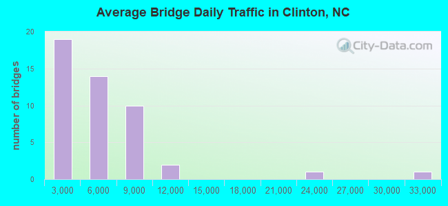
- 237,425Total average daily traffic
- 25,832Total average daily truck traffic
- National Bridge Inventory (NBI) Registered Bridges for Clinton
- No street view available for this location
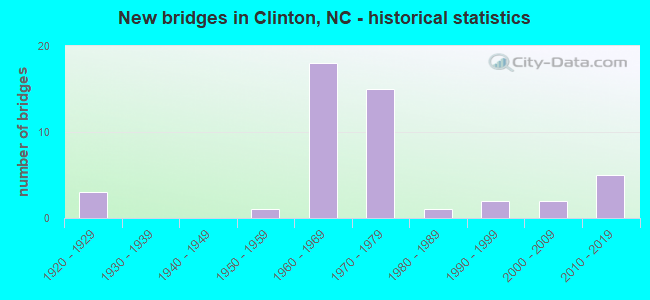
- New bridges - historical statistics
- 31920-1929
- 11950-1959
- 181960-1969
- 151970-1979
- 11980-1989
- 21990-1999
- 22000-2009
- 52010-2019
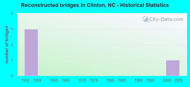
- Reconstructed bridges - Historical Statistics
- 31950-1959
- 01960-1969
- 01970-1979
- 01980-1989
- 01990-1999
- 12000-2009
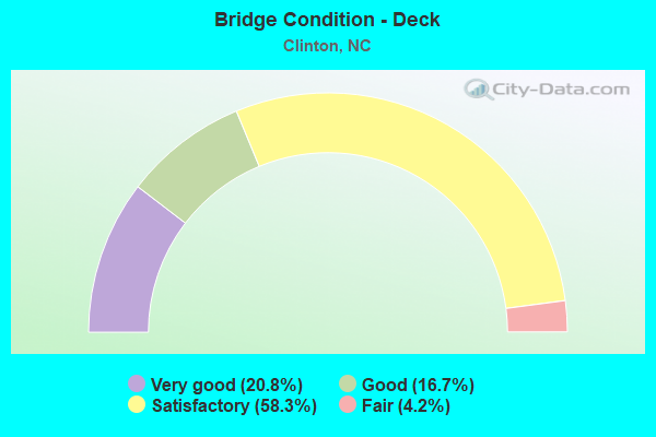
- Bridge Condition - Deck
- 20.8%Very good
- 16.7%Good
- 58.3%Satisfactory
- 4.2%Fair

- Bridge Condition - Superstructure
- 29.2%Very good
- 12.5%Good
- 54.2%Satisfactory
- 4.2%Fair
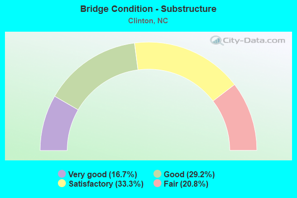
- Bridge Condition - Substructure
- 16.7%Very good
- 29.2%Good
- 33.3%Satisfactory
- 20.8%Fair
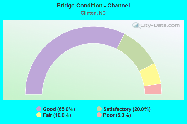
- Bridge Condition - Channel
- 65.0%Good
- 20.0%Satisfactory
- 10.0%Fair
- 5.0%Poor
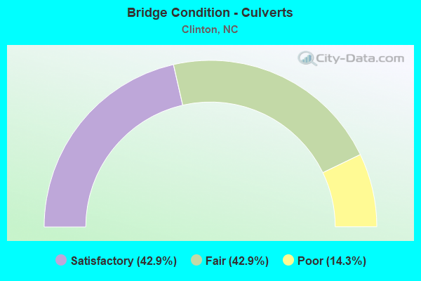
- Bridge Condition - Culverts
- 42.9%Satisfactory
- 42.9%Fair
- 14.3%Poor
Find on map >> Show street view
Structure Number: 870022, Location: 0.5 MI.S.JCT.SR1527 (Lat: 35.528481, Lng: -82.930417), Route carried "on" structure: US 19, Year Built: 1961, Year Reconstructed: 2013, Status: Open, Structure Length: 4.05m (13.29ft), Average Daily Traffic: 21,750 (year 2018), Truck Traffic: 12%, Average Future Daily Traffic: 43,500 (year 2040), Design Load: HS 20+Mod, Features Intersected: SR1532
Minimum Vertical Clearance: 30+ m (98+ ft), Kilometerpoint: 0.000, Lanes on structure: 4, Lanes under structure: 2, Base Highway Network: Yes (Inventory Route: 2, Subroute: 19), Owner: State Highway Agency, Approaching Roadway Width: 21.9m (71.9ft), Skew: 30 degrees, Material/Design: Steel, Design/Construction: Stringer/Multi-beam, Number Of Spans In Main Unit: 3, Length of Maximum Span: 14.0m (45.9ft), Curb-To-Curb Width: 21.0m (68.9ft), Out-to-Out Width: 22.6m (74.1ft)
Condition: Deck: Satisfactory, Superstructure: Satisfactory, Substructure: Satisfactory, Operating Rating: 58.0 metric tons, Method Used To Determine Operating Rating: Load Factor (LF), Inventory Rating: 34.4 metric tons, Method Used To Determine Inventory Rating: Load Factor (LF), Structural Evaluation: Equal to present minimum criteria, Deck Geometry: Better than present minimum criteria, Underclear: Somewhat better than minimum adequacy, Approach Roadway Alignment: Equal to present desirable criteria, Designated Inspection Frequency: Every 24 months, Inspection Date: May 2021, Deck Structure Type: Concrete Cast-file-Place, Wearing Surface/Protective System: Wearing Surface: Latex Concrete
Find on map >> Show street view
Structure Number: 1630001, Location: 0.4 MI. E. JCT. SR1934 (Lat: 34.967681, Lng: -78.283558), Route carried "on" structure: State highway 1932, Year Built: 1999, Status: Open, Structure Length: 1.24m (4.07ft), Average Daily Traffic: 2,000 (year 2018), Truck Traffic: 6%, Average Future Daily Traffic: 4,000 (year 2040), Design Load: HS 20+Mod, Features Intersected: ROWAN BRANCH
Minimum Vertical Clearance: 30+ m (98+ ft), Kilometerpoint: 0.000, Lanes on structure: 2, Owner: State Highway Agency, Approaching Roadway Width: 5.7m (18.7ft), Material/Design: Steel, Design/Construction: Culvert, Number Of Spans In Main Unit: 3, Length of Maximum Span: 3.6m (11.8ft)
Condition: Channel: Good, Culverts: Poor, Operating Rating: 89.8 metric tons, Method Used To Determine Operating Rating: Load and Resistance Factor (LRFR), Inventory Rating: 82.5 metric tons, Method Used To Determine Inventory Rating: Load and Resistance Factor (LRFR), Structural Evaluation: Meets minimum limits, Waterway Adequacy: Somewhat better than minimum adequacy, Approach Roadway Alignment: Equal to present desirable criteria, Designated Inspection Frequency: Every 24 months, Underwater Inspection Frequency: Every 60 months, Inspection Date: April 2020, Underwater Inspection Date: April 2020
Find on map >> Show street view
Structure Number: 1630002, Location: 0.2 MI. S. JCT. SR1749 (Lat: 35.015375, Lng: -78.324131), Route carried "on" structure: Business US 701, Year Built: 1977, Status: Open, Structure Length: 0.70m (2.30ft), Average Daily Traffic: 8,600 (year 2018), Truck Traffic: 6%, Average Future Daily Traffic: 17,200 (year 2040), Design Load: HS 20+Mod, Features Intersected: BEAVERDAM BRANCH
Minimum Vertical Clearance: 30+ m (98+ ft), Kilometerpoint: 0.000, Lanes on structure: 5, Owner: State Highway Agency, Approaching Roadway Width: 21.0m (68.9ft), Skew: 1 degrees, Material/Design: Concrete continuous, Design/Construction: Culvert, Number Of Spans In Main Unit: 3, Length of Maximum Span: 2.1m (6.9ft)
Condition: Channel: Satisfactory, Culverts: Fair, Operating Rating: 41.7 metric tons, Method Used To Determine Operating Rating: Field evaluation and documented engineering judgment, Inventory Rating: 32.6 metric tons, Method Used To Determine Inventory Rating: Field evaluation and documented engineering judgment, Structural Evaluation: Somewhat better than minimum adequacy, Waterway Adequacy: Better than present minimum criteria, Approach Roadway Alignment: Equal to present desirable criteria, Designated Inspection Frequency: Every 24 months, Underwater Inspection Frequency: Every 60 months, Inspection Date: Febuary 2022, Underwater Inspection Date: Febuary 2022
Find on map >> Show street view
Structure Number: 163001, Location: 0.6 MI.N.JCT.SR1842 (Lat: 35.048003, Lng: -78.368975), Route carried "on" structure: US 421, Year Built: 1920, Year Reconstructed: 1955, Status: Open, Structure Length: 2.19m (7.19ft), Average Daily Traffic: 6,700 (year 2019), Truck Traffic: 14%, Average Future Daily Traffic: 13,400 (year 2040), Design Load: H 15, Features Intersected: GREAT COHARIE SWAMP
Minimum Vertical Clearance: 30+ m (98+ ft), Kilometerpoint: 0.000, Lanes on structure: 2, Base Highway Network: Yes (Inventory Route: 2, Subroute: 21), Owner: State Highway Agency, Approaching Roadway Width: 8.5m (27.9ft), Material/Design: Concrete, Design/Construction: Tee Beam, Number Of Spans In Main Unit: 2, Length of Maximum Span: 10.3m (33.8ft), Curb or Sidewalk Widths: Left: 0.4m (1.3ft), Right: 0.4m (1.3ft), Curb-To-Curb Width: 8.5m (27.9ft), Out-to-Out Width: 10.1m (33.1ft)
Condition: Deck: Satisfactory, Superstructure: Fair, Substructure: Fair, Channel: Good, Operating Rating: 52.6 metric tons, Method Used To Determine Operating Rating: Load Factor (LF), Inventory Rating: 30.8 metric tons, Method Used To Determine Inventory Rating: Load Factor (LF), Structural Evaluation: Somewhat better than minimum adequacy, Deck Geometry: High priority of replacement, Waterway Adequacy: Better than present minimum criteria, Approach Roadway Alignment: Equal to present desirable criteria, Designated Inspection Frequency: Every 24 months, Underwater Inspection Frequency: Every 60 months, Inspection Date: July 2020, Underwater Inspection Date: May 2018, Deck Structure Type: Concrete Cast-file-Place, Wearing Surface/Protective System: Wearing Surface: Bituminous
Find on map >> Show street view
Structure Number: 163002, Location: 0.3 MI S JCT SR 1904 (Lat: 35.028614, Lng: -78.272272), Route carried "on" structure: State highway 403, Year Built: 2001, Status: Open, Structure Length: 2.34m (7.68ft), Average Daily Traffic: 5,800 (year 2019), Truck Traffic: 7%, Average Future Daily Traffic: 11,600 (year 2040), Design Load: HS 20+Mod, Features Intersected: BEAVERDAM SWAMP
Minimum Vertical Clearance: 30+ m (98+ ft), Kilometerpoint: 0.000, Lanes on structure: 2, Owner: State Highway Agency, Approaching Roadway Width: 8.2m (26.9ft), Material/Design: Prestressed concrete, Design/Construction: Slab, Number Of Spans In Main Unit: 2, Length of Maximum Span: 14.9m (48.9ft), Curb-To-Curb Width: 11.9m (39.0ft), Out-to-Out Width: 12.8m (42.0ft)
Condition: Deck: Very good, Superstructure: Very good, Substructure: Good, Channel: Good, Operating Rating: 74.3 metric tons, Method Used To Determine Operating Rating: Load Factor (LF), Inventory Rating: 44.4 metric tons, Method Used To Determine Inventory Rating: Load Factor (LF), Structural Evaluation: Better than present minimum criteria, Deck Geometry: Somewhat better than minimum adequacy, Waterway Adequacy: Better than present minimum criteria, Approach Roadway Alignment: Equal to present desirable criteria, Designated Inspection Frequency: Every 24 months, Underwater Inspection Frequency: Every 60 months, Inspection Date: May 2020, Underwater Inspection Date: March 2021, Deck Structure Type: Concrete Precast Panels, Wearing Surface/Protective System: Wearing Surface: Bituminous
Find on map >> Show street view
Structure Number: 1630023, Location: 0.6MI.N. OF SR1842 (Lat: 35.047450, Lng: -78.367950), Route carried "on" structure: US 421, Year Built: 1920, Year Reconstructed: 1955, Status: Open, Structure Length: 2.19m (7.19ft), Average Daily Traffic: 7,400 (year 2017), Truck Traffic: 14%, Average Future Daily Traffic: 14,800 (year 2025), Design Load: HS 15, Features Intersected: GREAT COHARIE CREEK
Minimum Vertical Clearance: 30+ m (98+ ft), Kilometerpoint: 0.000, Lanes on structure: 2, Base Highway Network: Yes (Inventory Route: 2, Subroute: 21), Owner: State Highway Agency, Approaching Roadway Width: 8.5m (27.9ft), Material/Design: Concrete, Design/Construction: Tee Beam, Number Of Spans In Main Unit: 2, Length of Maximum Span: 10.3m (33.8ft), Curb or Sidewalk Widths: Left: 0.4m (1.3ft), Right: 0.4m (1.3ft), Curb-To-Curb Width: 8.5m (27.9ft), Out-to-Out Width: 10.1m (33.1ft)
Condition: Deck: Satisfactory, Superstructure: Satisfactory, Substructure: Fair, Channel: Good, Operating Rating: 48.0 metric tons, Method Used To Determine Operating Rating: Load Factor (LF), Inventory Rating: 28.1 metric tons, Method Used To Determine Inventory Rating: Load Factor (LF), Structural Evaluation: Somewhat better than minimum adequacy, Deck Geometry: High priority of replacement, Waterway Adequacy: Better than present minimum criteria, Approach Roadway Alignment: Equal to present desirable criteria, Designated Inspection Frequency: Every 24 months, Underwater Inspection Frequency: Every 60 months, Inspection Date: July 2020, Underwater Inspection Date: May 2018, Deck Structure Type: Concrete Cast-file-Place
Find on map >> Show street view
Structure Number: 1630029, Location: 0.5 MI. N. JCT. SR1842 (Lat: 35.046725, Lng: -78.366594), Route carried "on" structure: US 421, Year Built: 1920, Year Reconstructed: 1955, Status: Open, Structure Length: 1.98m (6.50ft), Average Daily Traffic: 6,600 (year 2013), Truck Traffic: 14%, Average Future Daily Traffic: 13,200 (year 2025), Design Load: H 15, Features Intersected: GREAT COHARIE CREEK
Minimum Vertical Clearance: 30+ m (98+ ft), Kilometerpoint: 0.000, Lanes on structure: 2, Base Highway Network: Yes (Inventory Route: 2, Subroute: 21), Owner: State Highway Agency, Approaching Roadway Width: 8.5m (27.9ft), Material/Design: Concrete, Design/Construction: Tee Beam, Number Of Spans In Main Unit: 2, Length of Maximum Span: 10.3m (33.8ft), Curb or Sidewalk Widths: Left: 0.4m (1.3ft), Right: 0.4m (1.3ft), Curb-To-Curb Width: 8.5m (27.9ft), Out-to-Out Width: 9.5m (31.2ft)
Condition: Deck: Satisfactory, Superstructure: Satisfactory, Substructure: Fair, Channel: Good, Operating Rating: 50.8 metric tons, Method Used To Determine Operating Rating: Load Factor (LF), Inventory Rating: 29.9 metric tons, Method Used To Determine Inventory Rating: Load Factor (LF), Structural Evaluation: Somewhat better than minimum adequacy, Deck Geometry: High priority of replacement, Waterway Adequacy: Better than present minimum criteria, Approach Roadway Alignment: Equal to present desirable criteria, Designated Inspection Frequency: Every 24 months, Underwater Inspection Frequency: Every 60 months, Inspection Date: July 2020, Underwater Inspection Date: July 2019, Deck Structure Type: Concrete Cast-file-Place, Wearing Surface/Protective System: Wearing Surface: Bituminous
Find on map >> Show street view
Structure Number: 163003, Location: 1.0 MI S. OF SR1942 (Lat: 34.890944, Lng: -78.200750), Route carried "on" structure: State highway 1943, Year Built: 2013, Status: Open, Structure Length: 3.53m (11.58ft), Average Daily Traffic: 550 (year 2018), Truck Traffic: 6%, Average Future Daily Traffic: 1,100 (year 2040), Design Load: HL 93, Features Intersected: STEWARTS CREEK
Minimum Vertical Clearance: 30+ m (98+ ft), Kilometerpoint: 0.000, Lanes on structure: 2, Owner: State Highway Agency, Approaching Roadway Width: 8.2m (26.9ft), Material/Design: Prestressed concrete, Design/Construction: Slab, Number Of Spans In Main Unit: 3, Length of Maximum Span: 13.4m (44.0ft), Curb-To-Curb Width: 8.2m (26.9ft), Out-to-Out Width: 9.1m (29.9ft)
Condition: Deck: Very good, Superstructure: Very good, Substructure: Very good, Channel: Satisfactory, Operating Rating: 49.8 metric tons, Method Used To Determine Operating Rating: Load and Resistance Factor (LRFR), Inventory Rating: 38.1 metric tons, Method Used To Determine Inventory Rating: Load and Resistance Factor (LRFR), Structural Evaluation: Equal to present desirable criteria, Deck Geometry: Somewhat better than minimum adequacy, Waterway Adequacy: Better than present minimum criteria, Approach Roadway Alignment: Equal to present minimum criteria, Designated Inspection Frequency: Every 24 months, Inspection Date: July 2020, Deck Structure Type: Concrete Precast Panels, Wearing Surface/Protective System: Wearing Surface: Bituminous, Deck Protection: Epoxy Coated Reinforcing
Find on map >> Show street view
Structure Number: 1630039, Location: 1.2 MI N. JCT. SR1227 (Lat: 34.995108, Lng: -78.337550), Route carried "on" structure: US 421, Year Built: 1967, Status: Open, Structure Length: 4.05m (13.29ft), Average Daily Traffic: 7,000 (year 2018), Truck Traffic: 12%, Average Future Daily Traffic: 14,000 (year 2040), Design Load: HS 20+Mod, Features Intersected: NC24
Minimum Vertical Clearance: 30+ m (98+ ft), Kilometerpoint: 0.000, Lanes on structure: 2, Lanes under structure: 5, Base Highway Network: Yes (Inventory Route: 2, Subroute: 21), Owner: State Highway Agency, Approaching Roadway Width: 9.7m (31.8ft), Skew: 10 degrees, Material/Design: Steel, Design/Construction: Stringer/Multi-beam, Number Of Spans In Main Unit: 3, Length of Maximum Span: 19.8m (65.0ft), Curb-To-Curb Width: 12.2m (40.0ft), Out-to-Out Width: 12.8m (42.0ft)
Condition: Deck: Satisfactory, Superstructure: Satisfactory, Substructure: Satisfactory, Operating Rating: 62.5 metric tons, Method Used To Determine Operating Rating: Load Factor (LF), Inventory Rating: 37.1 metric tons, Method Used To Determine Inventory Rating: Load Factor (LF), Structural Evaluation: Equal to present minimum criteria, Deck Geometry: Better than present minimum criteria, Underclear: High priority of corrective action, Approach Roadway Alignment: Equal to present desirable criteria, Designated Inspection Frequency: Every 24 months, Inspection Date: May 2020, Deck Structure Type: Concrete Cast-file-Place, Wearing Surface/Protective System: Wearing Surface: Monolithic Concrete
Find on map >> Show street view
Structure Number: 1630041, Location: 1.4 MI.N. OF SR1146 (Lat: 34.965275, Lng: -78.305222), Route carried "on" structure: Business US 701, Year Built: 1967, Status: Open, Structure Length: 6.27m (20.57ft), Average Daily Traffic: 5,800 (year 2018), Truck Traffic: 6%, Average Future Daily Traffic: 11,600 (year 2040), Design Load: HS 20+Mod, Features Intersected: US421 & US701 NBL
Minimum Vertical Clearance: 30+ m (98+ ft), Kilometerpoint: 0.000, Lanes on structure: 2, Lanes under structure: 6, Owner: State Highway Agency, Approaching Roadway Width: 8.8m (28.9ft), Skew: 2 degrees, Material/Design: Steel, Design/Construction: Stringer/Multi-beam, Number Of Spans In Main Unit: 4, Length of Maximum Span: 23.1m (75.8ft), Curb-To-Curb Width: 10.3m (33.8ft), Out-to-Out Width: 10.9m (35.8ft)
Condition: Deck: Good, Superstructure: Satisfactory, Substructure: Satisfactory, Operating Rating: 80.7 metric tons, Method Used To Determine Operating Rating: Load Factor (LF), Inventory Rating: 48.0 metric tons, Method Used To Determine Inventory Rating: Load Factor (LF), Structural Evaluation: Equal to present minimum criteria, Deck Geometry: Meets minimum limits, Underclear: High priority of corrective action, Approach Roadway Alignment: Equal to present desirable criteria, Designated Inspection Frequency: Every 24 months, Inspection Date: June 2020, Deck Structure Type: Concrete Cast-file-Place, Wearing Surface/Protective System: Wearing Surface: Epoxy Overlay, Membrane: Epoxy
Find on map >> Show street view
Structure Number: 1630046, Location: 0.1 MI S. OF JCT SR 1839 (Lat: 35.007267, Lng: -78.340414), Route carried "on" structure: Bypass US 701, Year Built: 1972, Status: Open, Structure Length: 4.14m (13.58ft), Average Daily Traffic: 3,800 (year 2018), Truck Traffic: 12%, Average Future Daily Traffic: 7,600 (year 2040), Design Load: HS 20+Mod, Features Intersected: US421N
Minimum Vertical Clearance: 30+ m (98+ ft), Kilometerpoint: 0.000, Lanes on structure: 2, Lanes under structure: 2, Base Highway Network: Yes (Inventory Route: 2, Subroute: 1), Owner: State Highway Agency, Approaching Roadway Width: 9.4m (30.8ft), Skew: 4 degrees, Material/Design: Steel, Design/Construction: Stringer/Multi-beam, Number Of Spans In Main Unit: 3, Length of Maximum Span: 17.9m (58.7ft), Curb-To-Curb Width: 12.1m (39.7ft), Out-to-Out Width: 12.7m (41.7ft)
Condition: Deck: Satisfactory, Superstructure: Satisfactory, Substructure: Satisfactory, Operating Rating: 57.1 metric tons, Method Used To Determine Operating Rating: Load Factor (LF), Inventory Rating: 34.4 metric tons, Method Used To Determine Inventory Rating: Load Factor (LF), Structural Evaluation: Equal to present minimum criteria, Deck Geometry: Equal to present minimum criteria, Underclear: Meets minimum limits, Approach Roadway Alignment: Equal to present desirable criteria, Designated Inspection Frequency: Every 24 months, Inspection Date: May 2020, Deck Structure Type: Concrete Cast-file-Place, Wearing Surface/Protective System: Wearing Surface: Epoxy Overlay, Membrane: Epoxy
Find on map >> Show street view
Structure Number: 1630047, Location: 1.0 MI N JCT NC24 (Lat: 35.008719, Lng: -78.338978), Route carried "on" structure: Bypass US 701, Year Built: 1972, Status: Open, Structure Length: 4.38m (14.37ft), Average Daily Traffic: 3,050 (year 2017), Truck Traffic: 12%, Average Future Daily Traffic: 6,100 (year 2040), Design Load: HS 20+Mod, Features Intersected: SR1839
Minimum Vertical Clearance: 30+ m (98+ ft), Kilometerpoint: 0.000, Lanes on structure: 2, Lanes under structure: 2, Base Highway Network: Yes (Inventory Route: 2, Subroute: 1), Owner: State Highway Agency, Approaching Roadway Width: 12.1m (39.7ft), Skew: 12 degrees, Material/Design: Steel, Design/Construction: Stringer/Multi-beam, Number Of Spans In Main Unit: 3, Length of Maximum Span: 17.9m (58.7ft), Curb-To-Curb Width: 12.1m (39.7ft), Out-to-Out Width: 12.8m (42.0ft)
Condition: Deck: Good, Superstructure: Satisfactory, Substructure: Satisfactory, Operating Rating: 55.3 metric tons, Method Used To Determine Operating Rating: Load Factor (LF), Inventory Rating: 32.6 metric tons, Method Used To Determine Inventory Rating: Load Factor (LF), Structural Evaluation: Equal to present minimum criteria, Deck Geometry: Somewhat better than minimum adequacy, Underclear: Somewhat better than minimum adequacy, Approach Roadway Alignment: Equal to present desirable criteria, Designated Inspection Frequency: Every 24 months, Inspection Date: July 2020, Deck Structure Type: Concrete Cast-file-Place, Wearing Surface/Protective System: Wearing Surface: Epoxy Overlay, Membrane: Epoxy
Find on map >> Show street view
Structure Number: 1630048, Location: 1.0 MI.N.JCT.NC24 (Lat: 35.009006, Lng: -78.339347), Route carried "on" structure: Bypass US 701, Year Built: 1972, Status: Open, Structure Length: 3.77m (12.37ft), Average Daily Traffic: 3,000 (year 2013), Truck Traffic: 12%, Average Future Daily Traffic: 6,000 (year 2040), Design Load: HS 20+Mod, Features Intersected: SR1839
Minimum Vertical Clearance: 30+ m (98+ ft), Kilometerpoint: 0.000, Lanes on structure: 2, Lanes under structure: 2, Base Highway Network: Yes (Inventory Route: 2, Subroute: 1), Owner: State Highway Agency, Approaching Roadway Width: 9.7m (31.8ft), Skew: 11 degrees, Material/Design: Steel, Design/Construction: Stringer/Multi-beam, Number Of Spans In Main Unit: 3, Length of Maximum Span: 16.7m (54.8ft), Curb-To-Curb Width: 12.0m (39.4ft), Out-to-Out Width: 12.8m (42.0ft)
Condition: Deck: Satisfactory, Superstructure: Satisfactory, Substructure: Satisfactory, Operating Rating: 59.8 metric tons, Method Used To Determine Operating Rating: Load Factor (LF), Inventory Rating: 36.2 metric tons, Method Used To Determine Inventory Rating: Load Factor (LF), Structural Evaluation: Equal to present minimum criteria, Deck Geometry: Equal to present minimum criteria, Underclear: Somewhat better than minimum adequacy, Approach Roadway Alignment: Equal to present desirable criteria, Designated Inspection Frequency: Every 24 months, Inspection Date: July 2020, Deck Structure Type: Concrete Cast-file-Place, Wearing Surface/Protective System: Wearing Surface: Monolithic Concrete
Find on map >> Show street view
Structure Number: 1630049, Location: 0.3 MI N. JCT. US421 (Lat: 35.010014, Lng: -78.338306), Route carried "on" structure: Bypass US 701, Year Built: 1972, Status: Open, Structure Length: 1.43m (4.69ft), Average Daily Traffic: 5,900 (year 2018), Truck Traffic: 12%, Average Future Daily Traffic: 11,800 (year 2040), Design Load: HS 20+Mod, Features Intersected: WILLIAMS OLD MILL BR.
Minimum Vertical Clearance: 30+ m (98+ ft), Kilometerpoint: 0.000, Lanes on structure: 4, Base Highway Network: Yes (Inventory Route: 2, Subroute: 1), Owner: State Highway Agency, Approaching Roadway Width: 20.4m (66.9ft), Skew: 25 degrees, Material/Design: Concrete continuous, Design/Construction: Culvert, Number Of Spans In Main Unit: 3, Length of Maximum Span: 2.7m (8.9ft)
Condition: Channel: Satisfactory, Culverts: Satisfactory, Operating Rating: 39.0 metric tons, Method Used To Determine Operating Rating: Load and Resistance Factor (LRFR), Inventory Rating: 29.9 metric tons, Method Used To Determine Inventory Rating: Load and Resistance Factor (LRFR), Structural Evaluation: Equal to present minimum criteria, Waterway Adequacy: Better than present minimum criteria, Approach Roadway Alignment: Equal to present desirable criteria, Designated Inspection Frequency: Every 24 months, Inspection Date: July 2020
Find on map >> Show street view
Structure Number: 163005, Location: 0.4 MI S. OF JCT NC41 (Lat: 34.710911, Lng: -78.277658), Route carried "on" structure: State highway 1119, Year Built: 1989, Status: Open, Structure Length: 1.34m (4.40ft), Average Daily Traffic: 340 (year 2018), Truck Traffic: 6%, Average Future Daily Traffic: 680 (year 2040), Design Load: HS 20+Mod, Features Intersected: DEVANE BRANCH
Minimum Vertical Clearance: 30+ m (98+ ft), Kilometerpoint: 0.000, Lanes on structure: 2, Owner: State Highway Agency, Approaching Roadway Width: 5.4m (17.7ft), Skew: 1 degrees, Material/Design: Steel, Design/Construction: Culvert, Number Of Spans In Main Unit: 3, Length of Maximum Span: 3.6m (11.8ft)
Condition: Channel: Good, Culverts: Satisfactory, Operating Rating: 89.8 metric tons, Method Used To Determine Operating Rating: Load and Resistance Factor (LRFR), Inventory Rating: 89.8 metric tons, Method Used To Determine Inventory Rating: Load and Resistance Factor (LRFR), Structural Evaluation: Equal to present minimum criteria, Waterway Adequacy: Better than present minimum criteria, Approach Roadway Alignment: Equal to present desirable criteria, Designated Inspection Frequency: Every 24 months, Inspection Date: May 2020
Find on map >> Show street view
Structure Number: 1630051, Location: 1.1 MI. E. JCT. SR13 (Lat: 34.994511, Lng: -78.373936), Route carried "on" structure: State highway 24, Year Built: 2017, Status: Open, Structure Length: 5.48m (17.98ft), Average Daily Traffic: 8,500 (year 2018), Truck Traffic: 14%, Average Future Daily Traffic: 17,000 (year 2040), Design Load: HL 93, Features Intersected: GREAT COHARIE CR.
Minimum Vertical Clearance: 30+ m (98+ ft), Kilometerpoint: 0.000, Lanes on structure: 2, Base Highway Network: Yes (Inventory Route: 3, Subroute: 24), Owner: State Highway Agency, Approaching Roadway Width: 10.6m (34.8ft), Material/Design: Prestressed concrete continuous, Design/Construction: Stringer/Multi-beam, Number Of Spans In Main Unit: 3, Length of Maximum Span: 19.2m (63.0ft), Curb-To-Curb Width: 10.1m (33.1ft), Out-to-Out Width: 11.4m (37.4ft)
Condition: Deck: Satisfactory, Superstructure: Very good, Substructure: Very good, Channel: Good, Operating Rating: 67.1 metric tons, Method Used To Determine Operating Rating: Load and Resistance Factor (LRFR), Inventory Rating: 43.5 metric tons, Method Used To Determine Inventory Rating: Load and Resistance Factor (LRFR), Structural Evaluation: Equal to present desirable criteria, Deck Geometry: Meets minimum limits, Waterway Adequacy: Better than present minimum criteria, Approach Roadway Alignment: Equal to present desirable criteria, Designated Inspection Frequency: Every 24 months, Inspection Date: October 2021, Deck Structure Type: Concrete Cast-file-Place, Wearing Surface/Protective System: Wearing Surface: Monolithic Concrete, Deck Protection: Epoxy Coated Reinforcing
Find on map >> Show street view
Structure Number: 1630052, Location: .016 MI E JCT SR 1835 (Lat: 35.016428, Lng: -78.334350), Route carried "on" structure: State highway 1311, Year Built: 1972, Status: Open, Structure Length: 6.52m (21.39ft), Average Daily Traffic: 10,000 (year 2019), Truck Traffic: 7%, Average Future Daily Traffic: 20,000 (year 2040), Design Load: HS 20+Mod, Features Intersected: US701, Facility Carried by Structure: SR1352
Minimum Vertical Clearance: 30+ m (98+ ft), Kilometerpoint: 0.000, Lanes on structure: 5, Lanes under structure: 4, Owner: State Highway Agency, Approaching Roadway Width: 19.8m (65.0ft), Skew: 1 degrees, Material/Design: Steel continuous, Design/Construction: Stringer/Multi-beam, Number Of Spans In Main Unit: 2, Length of Maximum Span: 32.9m (107.9ft), Curb-To-Curb Width: 18.2m (59.7ft), Out-to-Out Width: 18.8m (61.7ft)
Condition: Deck: Satisfactory, Superstructure: Good, Substructure: Good, Operating Rating: 78.9 metric tons, Method Used To Determine Operating Rating: Load Factor (LF), Inventory Rating: 47.1 metric tons, Method Used To Determine Inventory Rating: Load Factor (LF), Structural Evaluation: Better than present minimum criteria, Deck Geometry: High priority of replacement, Underclear: Equal to present minimum criteria, Approach Roadway Alignment: Equal to present desirable criteria, Designated Inspection Frequency: Every 24 months, Inspection Date: July 2020, Deck Structure Type: Concrete Cast-file-Place, Wearing Surface/Protective System: Wearing Surface: Epoxy Overlay, Membrane: Epoxy
Find on map >> Show street view
Structure Number: 1630053, Location: 0.05 MI.E.JCT SR1289 (Lat: 34.987664, Lng: -78.328200), Route carried "on" structure: State highway 1214, Year Built: 1967, Status: Open, Structure Length: 9.02m (29.59ft), Average Daily Traffic: 4,000 (year 2017), Truck Traffic: 7%, Average Future Daily Traffic: 8,000 (year 2040), Design Load: HS 15, Features Intersected: US421/US701BYP.
Minimum Vertical Clearance: 30+ m (98+ ft), Kilometerpoint: 0.000, Lanes on structure: 2, Lanes under structure: 4, Owner: State Highway Agency, Approaching Roadway Width: 9.1m (29.9ft), Skew: 1 degrees, Material/Design: Steel, Design/Construction: Stringer/Multi-beam, Number Of Spans In Main Unit: 5, Length of Maximum Span: 22.2m (72.8ft), Curb or Sidewalk Widths: Left: 1.3m (4.3ft), Right: 1.3m (4.3ft), Curb-To-Curb Width: 8.5m (27.9ft), Out-to-Out Width: 11.7m (38.4ft)
Condition: Deck: Good, Superstructure: Good, Substructure: Good, Operating Rating: 48.9 metric tons, Method Used To Determine Operating Rating: Load Factor (LF), Inventory Rating: 29.0 metric tons, Method Used To Determine Inventory Rating: Load Factor (LF), Structural Evaluation: Better than present minimum criteria, Deck Geometry: Meets minimum limits, Underclear: High priority of corrective action, Approach Roadway Alignment: Equal to present desirable criteria, Designated Inspection Frequency: Every 24 months, Inspection Date: July 2020, Deck Structure Type: Concrete Cast-file-Place, Wearing Surface/Protective System: Wearing Surface: Monolithic Concrete
Find on map >> Show street view
Structure Number: 1630054, Location: .25 MI.W. JCT. SR 1227 (Lat: 34.986086, Lng: -78.324544), Route carried "on" structure: Ramp State highway 24, Year Built: 1967, Status: Open, Structure Length: 4.63m (15.19ft), Average Daily Traffic: 2,425 (year 2013), Truck Traffic: 12%, Average Future Daily Traffic: 4,850 (year 2040), Design Load: HS 20+Mod, Features Intersected: US421 NBL
Minimum Vertical Clearance: 30+ m (98+ ft), Kilometerpoint: 0.000, Lanes on structure: 1, Lanes under structure: 2, Owner: State Highway Agency, Approaching Roadway Width: 7.0m (23.0ft), Material/Design: Steel, Design/Construction: Stringer/Multi-beam, Number Of Spans In Main Unit: 3, Length of Maximum Span: 20.7m (67.9ft), Curb-To-Curb Width: 8.5m (27.9ft), Out-to-Out Width: 9.1m (29.9ft)
Condition: Deck: Satisfactory, Superstructure: Satisfactory, Substructure: Good, Operating Rating: 79.8 metric tons, Method Used To Determine Operating Rating: Load Factor (LF), Inventory Rating: 48.0 metric tons, Method Used To Determine Inventory Rating: Load Factor (LF), Structural Evaluation: Equal to present minimum criteria, Deck Geometry: Superior to present desirable criteria, Underclear: Equal to present minimum criteria, Approach Roadway Alignment: Equal to present minimum criteria, Designated Inspection Frequency: Every 24 months, Inspection Date: July 2020, Deck Structure Type: Concrete Cast-file-Place, Wearing Surface/Protective System: Wearing Surface: Monolithic Concrete
Find on map >> Show street view
Structure Number: 1630055, Location: 0.3 MI. SE. JCT. NC24 (Lat: 34.981769, Lng: -78.320353), Route carried "on" structure: State highway 1227, Year Built: 1967, Status: Open, Structure Length: 8.16m (26.77ft), Average Daily Traffic: 2,500 (year 2019), Truck Traffic: 7%, Average Future Daily Traffic: 5,000 (year 2040), Design Load: HS 20+Mod, Features Intersected: US421/US701BYP.
Minimum Vertical Clearance: 30+ m (98+ ft), Kilometerpoint: 0.000, Lanes on structure: 2, Lanes under structure: 4, Owner: State Highway Agency, Approaching Roadway Width: 7.3m (24.0ft), Skew: 4 degrees, Material/Design: Steel, Design/Construction: Stringer/Multi-beam, Number Of Spans In Main Unit: 4, Length of Maximum Span: 26.8m (87.9ft), Curb-To-Curb Width: 10.3m (33.8ft), Out-to-Out Width: 10.9m (35.8ft)
Condition: Deck: Good, Superstructure: Good, Substructure: Good, Operating Rating: 56.2 metric tons, Method Used To Determine Operating Rating: Load Factor (LF), Inventory Rating: 33.5 metric tons, Method Used To Determine Inventory Rating: Load Factor (LF), Structural Evaluation: Better than present minimum criteria, Deck Geometry: Meets minimum limits, Underclear: Meets minimum limits, Approach Roadway Alignment: Equal to present desirable criteria, Designated Inspection Frequency: Every 24 months, Inspection Date: July 2020, Deck Structure Type: Concrete Cast-file-Place, Wearing Surface/Protective System: Wearing Surface: Monolithic Concrete
Find on map >> Show street view
Structure Number: 1630057, Location: 0.56 MI. W. OF 701BUS (Lat: 34.971031, Lng: -78.310497), Route carried "on" structure: State highway 1226, Year Built: 1967, Status: Open, Structure Length: 5.60m (18.37ft), Average Daily Traffic: 1,400 (year 2015), Truck Traffic: 7%, Average Future Daily Traffic: 2,800 (year 2040), Design Load: H 15, Features Intersected: US421/US701BYP.
Minimum Vertical Clearance: 30+ m (98+ ft), Kilometerpoint: 0.000, Lanes on structure: 2, Lanes under structure: 4, Owner: State Highway Agency, Approaching Roadway Width: 7.3m (24.0ft), Skew: 1 degrees, Material/Design: Steel, Design/Construction: Stringer/Multi-beam, Number Of Spans In Main Unit: 4, Length of Maximum Span: 19.8m (65.0ft), Curb-To-Curb Width: 9.1m (29.9ft), Out-to-Out Width: 9.7m (31.8ft)
Condition: Deck: Satisfactory, Superstructure: Satisfactory, Substructure: Satisfactory, Operating Rating: 52.6 metric tons, Method Used To Determine Operating Rating: Load Factor (LF), Inventory Rating: 30.8 metric tons, Method Used To Determine Inventory Rating: Load Factor (LF), Structural Evaluation: Equal to present minimum criteria, Deck Geometry: Somewhat better than minimum adequacy, Underclear: Meets minimum limits, Approach Roadway Alignment: Equal to present minimum criteria, Designated Inspection Frequency: Every 24 months, Inspection Date: May 2020, Deck Structure Type: Concrete Cast-file-Place, Wearing Surface/Protective System: Wearing Surface: Monolithic Concrete
Find on map >> Show street view
Structure Number: 1630107, Location: 1.7 MI W. OF US421 (Lat: 35.024978, Lng: -78.371347), Route carried "on" structure: State highway 1311, Year Built: 1978, Status: Open, Structure Length: 4.14m (13.58ft), Average Daily Traffic: 5,100 (year 2017), Truck Traffic: 6%, Average Future Daily Traffic: 10,200 (year 2040), Design Load: HS 20+Mod, Features Intersected: GREAT COHARIE CREEK
Minimum Vertical Clearance: 30+ m (98+ ft), Kilometerpoint: 0.000, Lanes on structure: 2, Owner: State Highway Agency, Approaching Roadway Width: 6.7m (22.0ft), Material/Design: Prestressed concrete, Design/Construction: Slab, Number Of Spans In Main Unit: 3, Length of Maximum Span: 13.4m (44.0ft), Curb-To-Curb Width: 10.4m (34.1ft), Out-to-Out Width: 10.8m (35.4ft)
Condition: Deck: Satisfactory, Superstructure: Satisfactory, Substructure: Satisfactory, Channel: Good, Operating Rating: 45.3 metric tons, Method Used To Determine Operating Rating: Load Factor (LF), Inventory Rating: 27.2 metric tons, Method Used To Determine Inventory Rating: Load Factor (LF), Structural Evaluation: Equal to present minimum criteria, Deck Geometry: Meets minimum limits, Waterway Adequacy: Better than present minimum criteria, Approach Roadway Alignment: Equal to present desirable criteria, Designated Inspection Frequency: Every 24 months, Underwater Inspection Frequency: Every 60 months, Inspection Date: June 2020, Underwater Inspection Date: July 2018, Deck Structure Type: Concrete Precast Panels, Wearing Surface/Protective System: Wearing Surface: Bituminous
Find on map >> Show street view
Structure Number: 1630224, Location: 1.5MI.N. JCT.SR 1151 (Lat: 35.043019, Lng: -78.290536), Route carried "on" structure: State highway 1742, Year Built: 2018, Status: Open, Structure Length: 3.13m (10.27ft), Average Daily Traffic: 680 (year 2014), Truck Traffic: 6%, Average Future Daily Traffic: 1,360 (year 2040), Design Load: HL 93, Features Intersected: BEAVERDAM CREEK
Minimum Vertical Clearance: 30+ m (98+ ft), Kilometerpoint: 0.000, Lanes on structure: 2, Owner: State Highway Agency, Approaching Roadway Width: 9.4m (30.8ft), Skew: 1 degrees, Material/Design: Prestressed concrete, Design/Construction: Slab, Number Of Spans In Main Unit: 2, Length of Maximum Span: 14.9m (48.9ft), Curb-To-Curb Width: 9.2m (30.2ft), Out-to-Out Width: 10.0m (32.8ft)
Condition: Deck: Very good, Superstructure: Very good, Substructure: Very good, Channel: Good, Operating Rating: 59.8 metric tons, Method Used To Determine Operating Rating: Load and Resistance Factor (LRFR), Inventory Rating: 46.2 metric tons, Method Used To Determine Inventory Rating: Load and Resistance Factor (LRFR), Structural Evaluation: Equal to present desirable criteria, Deck Geometry: Equal to present minimum criteria, Waterway Adequacy: Better than present minimum criteria, Approach Roadway Alignment: Equal to present minimum criteria, Designated Inspection Frequency: Every 24 months, Underwater Inspection Frequency: Every 60 months, Inspection Date: May 2020, Underwater Inspection Date: Febuary 2022, Deck Structure Type: Concrete Precast Panels, Wearing Surface/Protective System: Wearing Surface: Bituminous, Deck Protection: Epoxy Coated Reinforcing
Find on map >> Show street view
Structure Number: 1630354, Location: 0.7 MI.S. OF JCT.SR1904 (Lat: 35.024669, Lng: -78.261553), Route carried "on" structure: State highway 1918, Year Built: 2001, Status: Open, Structure Length: 2.65m (8.69ft), Average Daily Traffic: 640 (year 2015), Truck Traffic: 6%, Average Future Daily Traffic: 1,280 (year 2040), Design Load: HS 20+Mod, Features Intersected: BEAVERDAM SWAMP
Minimum Vertical Clearance: 30+ m (98+ ft), Kilometerpoint: 0.000, Lanes on structure: 2, Owner: State Highway Agency, Approaching Roadway Width: 8.2m (26.9ft), Material/Design: Prestressed concrete, Design/Construction: Slab, Number Of Spans In Main Unit: 2, Length of Maximum Span: 14.9m (48.9ft), Curb-To-Curb Width: 8.2m (26.9ft), Out-to-Out Width: 9.1m (29.9ft)
Condition: Deck: Very good, Superstructure: Very good, Substructure: Good, Channel: Good, Operating Rating: 74.3 metric tons, Method Used To Determine Operating Rating: Load Factor (LF), Inventory Rating: 44.4 metric tons, Method Used To Determine Inventory Rating: Load Factor (LF), Structural Evaluation: Better than present minimum criteria, Deck Geometry: Somewhat better than minimum adequacy, Waterway Adequacy: Better than present minimum criteria, Approach Roadway Alignment: Equal to present desirable criteria, Designated Inspection Frequency: Every 24 months, Underwater Inspection Frequency: Every 60 months, Inspection Date: May 2020, Underwater Inspection Date: Febuary 2022, Deck Structure Type: Concrete Precast Panels, Wearing Surface/Protective System: Wearing Surface: Bituminous
Find on map >> Show street view
Structure Number: 1630361, Location: 0.5 MI. S. JCT. NC55 (Lat: 35.238794, Lng: -78.392381), Route carried "on" structure: State highway 1647, Year Built: 1950, Status: Posted for load, Structure Length: 1.76m (5.77ft), Average Daily Traffic: 530 (year 2012), Truck Traffic: 6%, Average Future Daily Traffic: 1,060 (year 2040), Features Intersected: GREAT COHARIE CREEK
Minimum Vertical Clearance: 30+ m (98+ ft), Kilometerpoint: 0.000, Lanes on structure: 2, Owner: State Highway Agency, Approaching Roadway Width: 5.4m (17.7ft), Material/Design: Wood or Timber, Design/Construction: Stringer/Multi-beam, Number Of Spans In Main Unit: 3, Length of Maximum Span: 5.7m (18.7ft), Curb or Sidewalk Widths: Left: 0.2m (0.7ft), Right: 0.2m (0.7ft), Curb-To-Curb Width: 7.3m (24.0ft), Out-to-Out Width: 8.2m (26.9ft)
Condition: Deck: Fair, Superstructure: Satisfactory, Substructure: Fair, Channel: Satisfactory, Operating Rating: 29.9 metric tons, Method Used To Determine Operating Rating: Allowable Stress (AS), Inventory Rating: 15.4 metric tons, Method Used To Determine Inventory Rating: Allowable Stress (AS), Structural Evaluation: Meets minimum limits, Deck Geometry: Meets minimum limits, Waterway Adequacy: Somewhat better than minimum adequacy, Approach Roadway Alignment: Equal to present desirable criteria, Bridge Posting: Required (Relationship of Operating Rating to Maximum Legal Load: 10.0 - 19.9% below), Designated Inspection Frequency: Every 24 months, Underwater Inspection Frequency: Every 48 months, Inspection Date: April 2020, Underwater Inspection Date: July 2018, Deck Structure Type: Concrete Cast-file-Place, Wearing Surface/Protective System: Wearing Surface: Monolithic Concrete
Find on map >> Show street view
Structure Number: 1630368, Location: 1 MI.S.JCT NC24 (Lat: 34.982517, Lng: -78.351889), Route carried "on" structure: State highway 1229, Year Built: 1999, Status: Open, Structure Length: 0.67m (2.20ft), Average Daily Traffic: 3,000 (year 2016), Truck Traffic: 7%, Average Future Daily Traffic: 6,000 (year 2040), Design Load: HS 20+Mod, Features Intersected: BR. GREAT COHARIE
Minimum Vertical Clearance: 30+ m (98+ ft), Kilometerpoint: 0.000, Lanes on structure: 2, Owner: State Highway Agency, Approaching Roadway Width: 5.4m (17.7ft), Material/Design: Steel, Design/Construction: Culvert, Number Of Spans In Main Unit: 2, Length of Maximum Span: 2.7m (8.9ft)
Condition: Channel: Poor, Culverts: Satisfactory, Operating Rating: 89.8 metric tons, Method Used To Determine Operating Rating: Load and Resistance Factor (LRFR), Inventory Rating: 89.8 metric tons, Method Used To Determine Inventory Rating: Load and Resistance Factor (LRFR), Structural Evaluation: Equal to present minimum criteria, Waterway Adequacy: Better than present minimum criteria, Approach Roadway Alignment: Equal to present desirable criteria, Designated Inspection Frequency: Every 24 months, Inspection Date: June 2020
Find on map >> Show street view
Structure Number: 1630375, Location: 0.4MI.W.JCT.SR1337 (Lat: 35.157069, Lng: -78.456911), Route carried "on" structure: State highway 1811, Year Built: 1977, Status: Open, Structure Length: 2.46m (8.07ft), Average Daily Traffic: 90 (year 2015), Truck Traffic: 6%, Average Future Daily Traffic: 180 (year 2040), Design Load: HS 15, Features Intersected: LITTLE COHARIE CR
Minimum Vertical Clearance: 30+ m (98+ ft), Kilometerpoint: 0.000, Lanes on structure: 2, Owner: State Highway Agency, Approaching Roadway Width: 5.4m (17.7ft), Material/Design: Prestressed concrete, Design/Construction: Slab, Number Of Spans In Main Unit: 2, Length of Maximum Span: 11.5m (37.7ft), Curb-To-Curb Width: 8.9m (29.2ft), Out-to-Out Width: 10.0m (32.8ft)
Condition: Deck: Satisfactory, Superstructure: Satisfactory, Substructure: Fair, Channel: Good, Operating Rating: 43.5 metric tons, Method Used To Determine Operating Rating: Load Factor (LF), Inventory Rating: 26.3 metric tons, Method Used To Determine Inventory Rating: Load Factor (LF), Structural Evaluation: Somewhat better than minimum adequacy, Deck Geometry: Better than present minimum criteria, Waterway Adequacy: Equal to present desirable criteria, Approach Roadway Alignment: Equal to present desirable criteria, Designated Inspection Frequency: Every 24 months, Inspection Date: April 2020, Deck Structure Type: Concrete Precast Panels, Wearing Surface/Protective System: Wearing Surface: Bituminous
Find on map >> Show street view
Structure Number: 1630376, Location: 0.4 MI S. JCT. US701 BUS (Lat: 35.012442, Lng: -78.325483), Route carried "on" structure: State highway 1838, Year Built: 2019, Status: Open, Structure Length: 2.19m (7.19ft), Average Daily Traffic: 5,300 (year 2018), Truck Traffic: 7%, Average Future Daily Traffic: 10,600 (year 2040), Features Intersected: WILLIAMS OLD MILL BR.
Minimum Vertical Clearance: 30+ m (98+ ft), Kilometerpoint: 0.000, Lanes on structure: 3, Owner: State Highway Agency, Approaching Roadway Width: 15.5m (50.9ft), Skew: 1 degrees, Material/Design: Prestressed concrete, Design/Construction: Slab, Number Of Spans In Main Unit: 1, Length of Maximum Span: 21.0m (68.9ft), Curb or Sidewalk Widths: Left: 1.6m (5.2ft), Right: 1.6m (5.2ft), Curb-To-Curb Width: 12.2m (40.0ft), Out-to-Out Width: 16.4m (53.8ft)
Condition: Deck: Very good, Superstructure: Very good, Substructure: Very good, Channel: Good, Operating Rating: 58.0 metric tons, Method Used To Determine Operating Rating: Load and Resistance Factor (LRFR), Inventory Rating: 42.6 metric tons, Method Used To Determine Inventory Rating: Load and Resistance Factor (LRFR), Structural Evaluation: Equal to present desirable criteria, Deck Geometry: Meets minimum limits, Waterway Adequacy: Better than present minimum criteria, Approach Roadway Alignment: Equal to present desirable criteria, Designated Inspection Frequency: Every 24 months, Inspection Date: March 2021, Deck Structure Type: Concrete Cast-file-Place, Wearing Surface/Protective System: Wearing Surface: Monolithic Concrete
Find on map >> Show street view
Structure Number: 163038, Location: 0.2 MI. S. OF JCT. US421 (Lat: 35.009375, Lng: -78.339825), Route carried "on" structure: State highway 1839, Year Built: 1975, Status: Open, Structure Length: 0.85m (2.79ft), Average Daily Traffic: 2,000 (year 2018), Truck Traffic: 7%, Average Future Daily Traffic: 4,000 (year 2040), Design Load: HS 20+Mod, Features Intersected: WILLIAMS OLD MILL BRANCH
Minimum Vertical Clearance: 30+ m (98+ ft), Kilometerpoint: 0.000, Lanes on structure: 2, Owner: State Highway Agency, Approaching Roadway Width: 10.9m (35.8ft), Material/Design: Concrete continuous, Design/Construction: Culvert, Number Of Spans In Main Unit: 3, Length of Maximum Span: 2.7m (8.9ft)
Condition: Channel: Fair, Culverts: Fair, Operating Rating: 71.6 metric tons, Method Used To Determine Operating Rating: Load and Resistance Factor (LRFR), Inventory Rating: 55.3 metric tons, Method Used To Determine Inventory Rating: Load and Resistance Factor (LRFR), Structural Evaluation: Somewhat better than minimum adequacy, Waterway Adequacy: Better than present minimum criteria, Approach Roadway Alignment: Equal to present minimum criteria, Designated Inspection Frequency: Every 24 months, Underwater Inspection Frequency: Every 60 months, Inspection Date: October 2021, Underwater Inspection Date: October 2021
Find on map >> Show street view
Structure Number: 1630387, Location: 0.2 MI. S. OF JCT. SR1839 (Lat: 35.008253, Lng: -78.341142), Route carried "on" structure: US 421, Year Built: 1977, Status: Open, Structure Length: 0.82m (2.69ft), Average Daily Traffic: 7,400 (year 2019), Truck Traffic: 12%, Average Future Daily Traffic: 14,800 (year 2040), Features Intersected: WILLIAMS OLD MILL BRANCH
Minimum Vertical Clearance: 30+ m (98+ ft), Kilometerpoint: 0.000, Lanes on structure: 4, Base Highway Network: Yes (Inventory Route: 2, Subroute: 21), Owner: State Highway Agency, Approaching Roadway Width: 21.6m (70.9ft), Material/Design: Concrete continuous, Design/Construction: Culvert, Number Of Spans In Main Unit: 3, Length of Maximum Span: 2.4m (7.9ft)
Condition: Channel: Fair, Culverts: Fair, Operating Rating: 41.7 metric tons, Method Used To Determine Operating Rating: Field evaluation and documented engineering judgment, Inventory Rating: 32.6 metric tons, Method Used To Determine Inventory Rating: Field evaluation and documented engineering judgment, Structural Evaluation: Somewhat better than minimum adequacy, Waterway Adequacy: Somewhat better than minimum adequacy, Approach Roadway Alignment: Equal to present minimum criteria, Designated Inspection Frequency: Every 24 months, Underwater Inspection Frequency: Every 60 months, Inspection Date: October 2021, Underwater Inspection Date: October 2021
Find on map >> Show street view
Structure Number: 1630435, Location: 1.2 MI. E. OF JCT. SR1309 (Lat: 34.994500, Lng: -78.373500), Route carried "on" structure: State highway 24, Year Built: 2015, Status: Open, Structure Length: 5.48m (17.98ft), Average Daily Traffic: 8,500 (year 2018), Truck Traffic: 14%, Average Future Daily Traffic: 17,000 (year 2040), Design Load: HL 93, Features Intersected: GREAT COHARIE CREEK
Minimum Vertical Clearance: 30+ m (98+ ft), Kilometerpoint: 0.000, Lanes on structure: 2, Base Highway Network: Yes (Inventory Route: 3, Subroute: 24), Owner: State Highway Agency, Approaching Roadway Width: 10.9m (35.8ft), Skew: 10 degrees, Material/Design: Prestressed concrete continuous, Design/Construction: Stringer/Multi-beam, Number Of Spans In Main Unit: 3, Number Of Approach Spans: 2, Length of Maximum Span: 19.2m (63.0ft), Curb-To-Curb Width: 10.8m (35.4ft), Out-to-Out Width: 11.9m (39.0ft)
Condition: Deck: Satisfactory, Superstructure: Very good, Substructure: Good, Channel: Good, Operating Rating: 67.1 metric tons, Method Used To Determine Operating Rating: Load and Resistance Factor (LRFR), Inventory Rating: 43.5 metric tons, Method Used To Determine Inventory Rating: Load and Resistance Factor (LRFR), Structural Evaluation: Better than present minimum criteria, Deck Geometry: Somewhat better than minimum adequacy, Waterway Adequacy: Better than present minimum criteria, Approach Roadway Alignment: Equal to present desirable criteria, Designated Inspection Frequency: Every 24 months, Underwater Inspection Frequency: Every 60 months, Inspection Date: October 2021, Underwater Inspection Date: August 2021, Deck Structure Type: Concrete Cast-file-Place, Wearing Surface/Protective System: Wearing Surface: Monolithic Concrete
Find on map >> Show street view
Structure Number: 870022, Location: 0.5 MI.S.JCT.SR1527 (Lat: 35.528481, Lng: -82.930417), Route carried "under" structure: State highway 1532, Year Built: 1961, Structure Length: 0. m, Average Daily Traffic: 500 (year 2018), Truck Traffic: 7%, Features Intersected: US19,23,74
Minimum Vertical Clearance: 4.57m (14.99ft), Kilometerpoint: 0.000, Lanes on structure: 4, Lanes under structure: 2, Material/Design: Steel, Design/Construction: Stringer/Multi-beam, Length of Maximum Span: 14.0m (45.9ft)
Find on map >> Show street view
Structure Number: 1630039, Location: 1.2 MI N. JCT. SR1227 (Lat: 34.995108, Lng: -78.337550), Route carried "under" structure: State highway 24, Year Built: 1967, Structure Length: 0. m, Average Daily Traffic: 32,000 (year 2018), Truck Traffic: 12%, Features Intersected: US421S
Minimum Vertical Clearance: 4.77m (15.65ft), Kilometerpoint: 0.000, Lanes on structure: 2, Lanes under structure: 5, Material/Design: Steel, Design/Construction: Stringer/Multi-beam, Length of Maximum Span: 19.8m (65.0ft)
Find on map >> Show street view
Structure Number: 1630041, Location: 1.4 MI.N. OF SR1146 (Lat: 34.965275, Lng: -78.305222), Route carried "under" structure: US 421, Year Built: 1967, Structure Length: 0. m, Average Daily Traffic: 3,250 (year 2017), Truck Traffic: 12%, Features Intersected: US701B
Minimum Vertical Clearance: 4.54m (14.90ft), Kilometerpoint: 0.000, Lanes on structure: 2, Lanes under structure: 3, Material/Design: Steel, Design/Construction: Stringer/Multi-beam, Length of Maximum Span: 23.1m (75.8ft)
Find on map >> Show street view
Structure Number: 1630041, Location: 1.4 MI.N. OF SR1146 (Lat: 34.965275, Lng: -78.305222), Route carried "under" structure: US 421, Year Built: 1967, Structure Length: 0. m, Average Daily Traffic: 3,250 (year 2017), Truck Traffic: 12%, Features Intersected: US701B
Minimum Vertical Clearance: 4.69m (15.39ft), Kilometerpoint: 0.000, Lanes on structure: 2, Lanes under structure: 3, Material/Design: Steel, Design/Construction: Stringer/Multi-beam, Length of Maximum Span: 23.1m (75.8ft)
Find on map >> Show street view
Structure Number: 1630046, Location: 0.1 MI S. OF JCT SR 1839 (Lat: 35.007267, Lng: -78.340414), Route carried "under" structure: US 421, Year Built: 1972, Structure Length: 0. m, Average Daily Traffic: 9,750 (year 2018), Truck Traffic: 12%, Features Intersected: US701BYP
Minimum Vertical Clearance: 4.81m (15.78ft), Kilometerpoint: 0.000, Lanes on structure: 2, Lanes under structure: 2, Material/Design: Steel, Design/Construction: Stringer/Multi-beam, Length of Maximum Span: 17.9m (58.7ft)
Find on map >> Show street view
Structure Number: 1630047, Location: 1.0 MI N JCT NC24 (Lat: 35.008719, Lng: -78.338978), Route carried "under" structure: State highway 1839, Year Built: 1972, Structure Length: 0. m, Average Daily Traffic: 2,100 (year 2016), Truck Traffic: 7%, Features Intersected: US701BYP.
Minimum Vertical Clearance: 5.38m (17.65ft), Kilometerpoint: 0.000, Lanes on structure: 2, Lanes under structure: 2, Material/Design: Steel, Design/Construction: Stringer/Multi-beam, Length of Maximum Span: 17.9m (58.7ft)
Find on map >> Show street view
Structure Number: 1630048, Location: 1.0 MI.N.JCT.NC24 (Lat: 35.009006, Lng: -78.339347), Route carried "under" structure: State highway 1839, Year Built: 1972, Structure Length: 0. m, Average Daily Traffic: 2,400 (year 2012), Truck Traffic: 7%, Features Intersected: US701BYP SBL
Minimum Vertical Clearance: 5.00m (16.40ft), Kilometerpoint: 0.000, Lanes on structure: 2, Lanes under structure: 2, Material/Design: Steel, Design/Construction: Stringer/Multi-beam, Length of Maximum Span: 16.7m (54.8ft)
Find on map >> Show street view
Structure Number: 1630052, Location: .016 MI E JCT SR 1835 (Lat: 35.016428, Lng: -78.334350), Route carried "under" structure: US 701, Year Built: 1972, Structure Length: 0. m, Average Daily Traffic: 3,000 (year 2019), Truck Traffic: 12%, Features Intersected: SR1352
Minimum Vertical Clearance: 5.18m (16.99ft), Kilometerpoint: 0.000, Lanes on structure: 5, Lanes under structure: 2, Material/Design: Steel continuous, Design/Construction: Stringer/Multi-beam, Length of Maximum Span: 32.9m (107.9ft)
Find on map >> Show street view
Structure Number: 1630052, Location: .016 MI E JCT SR 1835 (Lat: 35.016428, Lng: -78.334350), Route carried "under" structure: US 701, Year Built: 1972, Structure Length: 0. m, Average Daily Traffic: 3,000 (year 2019), Truck Traffic: 12%, Features Intersected: SR1352
Minimum Vertical Clearance: 5.48m (17.98ft), Kilometerpoint: 0.000, Lanes on structure: 5, Lanes under structure: 2, Material/Design: Steel continuous, Design/Construction: Stringer/Multi-beam, Length of Maximum Span: 32.9m (107.9ft)
Find on map >> Show street view
Structure Number: 1630053, Location: 0.05 MI.E.JCT SR1289 (Lat: 34.987664, Lng: -78.328200), Route carried "under" structure: US 421, Year Built: 1967, Structure Length: 0. m, Average Daily Traffic: 7,000 (year 2018), Truck Traffic: 12%, Features Intersected: SR1214
Minimum Vertical Clearance: 4.90m (16.08ft), Kilometerpoint: 0.000, Lanes on structure: 2, Lanes under structure: 2, Material/Design: Steel, Design/Construction: Stringer/Multi-beam, Length of Maximum Span: 22.2m (72.8ft)
Find on map >> Show street view
Structure Number: 1630053, Location: 0.05 MI.E.JCT SR1289 (Lat: 34.987664, Lng: -78.328200), Route carried "under" structure: US 421, Year Built: 1967, Structure Length: 0. m, Average Daily Traffic: 7,000 (year 2018), Truck Traffic: 12%, Features Intersected: SR1214
Minimum Vertical Clearance: 6.00m (19.69ft), Kilometerpoint: 0.000, Lanes on structure: 2, Lanes under structure: 2, Material/Design: Steel, Design/Construction: Stringer/Multi-beam, Length of Maximum Span: 22.2m (72.8ft)
Find on map >> Show street view
Structure Number: 1630054, Location: .25 MI.W. JCT. SR 1227 (Lat: 34.986086, Lng: -78.324544), Route carried "under" structure: US 421, Year Built: 1967, Structure Length: 0. m, Average Daily Traffic: 2,620 (year 2013), Truck Traffic: 12%, Features Intersected: NC24 RAMP
Minimum Vertical Clearance: 4.82m (15.81ft), Kilometerpoint: 0.000, Lanes on structure: 1, Lanes under structure: 2, Material/Design: Steel, Design/Construction: Stringer/Multi-beam, Length of Maximum Span: 20.7m (67.9ft)
Find on map >> Show street view
Structure Number: 1630055, Location: 0.3 MI. SE. JCT. NC24 (Lat: 34.981769, Lng: -78.320353), Route carried "under" structure: Bypass US 421, Year Built: 1967, Structure Length: 0. m, Average Daily Traffic: 2,800 (year 2013), Truck Traffic: 12%, Features Intersected: SR1227
Minimum Vertical Clearance: 4.69m (15.39ft), Kilometerpoint: 0.000, Lanes on structure: 2, Lanes under structure: 2, Material/Design: Steel, Design/Construction: Stringer/Multi-beam, Length of Maximum Span: 26.8m (87.9ft)
Find on map >> Show street view
Structure Number: 1630055, Location: 0.3 MI. SE. JCT. NC24 (Lat: 34.981769, Lng: -78.320353), Route carried "under" structure: Bypass US 421, Year Built: 1967, Structure Length: 0. m, Average Daily Traffic: 2,800 (year 2013), Truck Traffic: 12%, Features Intersected: SR1227
Minimum Vertical Clearance: 4.62m (15.16ft), Kilometerpoint: 0.000, Lanes on structure: 2, Lanes under structure: 2, Material/Design: Steel, Design/Construction: Stringer/Multi-beam, Length of Maximum Span: 26.8m (87.9ft)
Find on map >> Show street view
Structure Number: 1630057, Location: 0.56 MI. W. OF 701BUS (Lat: 34.971031, Lng: -78.310497), Route carried "under" structure: US 421, Year Built: 1967, Structure Length: 0. m, Average Daily Traffic: 2,800 (year 2013), Truck Traffic: 12%, Features Intersected: SR1226
Minimum Vertical Clearance: 4.67m (15.32ft), Kilometerpoint: 0.000, Lanes on structure: 2, Lanes under structure: 2, Material/Design: Steel, Design/Construction: Stringer/Multi-beam, Length of Maximum Span: 19.8m (65.0ft)
Find on map >> Show street view
Structure Number: 1630057, Location: 0.56 MI. W. OF 701BUS (Lat: 34.971031, Lng: -78.310497), Route carried "under" structure: US 421, Year Built: 1967, Structure Length: 0. m, Average Daily Traffic: 2,800 (year 2013), Truck Traffic: 12%, Features Intersected: SR1226
Minimum Vertical Clearance: 4.69m (15.39ft), Kilometerpoint: 0.000, Lanes on structure: 2, Lanes under structure: 2, Material/Design: Steel, Design/Construction: Stringer/Multi-beam, Length of Maximum Span: 19.8m (65.0ft)