Bridge Statistics for Chicago Heights, Illinois (IL)
Condition, Traffic, Stress, Structural Evaluation, Project Costs
- National Bridge Inventory (NBI) Statistics
- 14Number of bridges
- 49ft / 15.3mTotal length
- $509,000Total costs
- 167,525Total average daily traffic
- 12,893Total average daily truck traffic
- National Bridge Inventory (NBI) Registered Bridges for Chicago Heights
- No street view available for this location
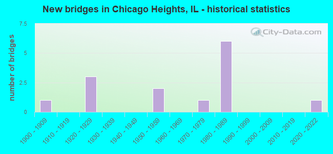
- New bridges - historical statistics
- 11900-1909
- 31920-1929
- 21950-1959
- 11970-1979
- 61980-1989
- 12020-2022

- Reconstructed bridges - Historical Statistics
- 11980-1989
- 01990-1999
- 02000-2009
- 12010-2019


- Bridge Condition - Deck
- 14.3%Good
- 57.1%Satisfactory
- 28.6%Fair

- Bridge Condition - Superstructure
- 14.3%Good
- 57.1%Satisfactory
- 28.6%Fair

- Bridge Condition - Substructure
- 14.3%Very good
- 28.6%Good
- 57.1%Satisfactory

- Bridge Condition - Channel
- 10.0%Very good
- 30.0%Satisfactory
- 50.0%Fair
- 10.0%Poor

- Bridge Condition - Culverts
- 33.3%Very good
- 66.7%Satisfactory
Find on map >> Show street view
Structure Number: 160919, Location: 0.5 M E IL 1 (Lat: 41.520703, Lng: -87.625531), Route carried "on" structure: Other road , Year Built: 1958, Status: Open, Structure Length: 1.41m (4.63ft), Average Daily Traffic: 16,600 (year 2021), Truck Traffic: 9%, Average Future Daily Traffic: 17,922 (year 2032), Design Load: H 20, Features Intersected: THORN CREEK, Facility Carried by Structure: JOE ORR RD
Minimum Vertical Clearance: 30+ m (98+ ft), Kilometerpoint: 4.104, Lanes on structure: 4, Base Highway Network: Yes, Owner: State Highway Agency, Approaching Roadway Width: 14.6m (47.9ft), Skew: 3 degrees, Material/Design: Steel, Design/Construction: Stringer/Multi-beam, Number Of Spans In Main Unit: 1, Length of Maximum Span: 12.8m (42.0ft), Curb or Sidewalk Widths: Left: 1.5m (4.9ft), Right: 1.5m (4.9ft), Curb-To-Curb Width: 14.6m (47.9ft), Out-to-Out Width: 17.7m (58.1ft)
Condition: Deck: Fair, Superstructure: Fair, Substructure: Satisfactory, Channel: Fair, Operating Rating: 58.6 metric tons, Method Used To Determine Operating Rating: Load Factor (LF) rating reported by rating factor (RF) method using MS18 loading, Inventory Rating: 35.3 metric tons, Method Used To Determine Inventory Rating: Load Factor (LF) rating reported by rating factor (RF) method using MS18 loading, Structural Evaluation: Somewhat better than minimum adequacy, Deck Geometry: High priority of replacement, Waterway Adequacy: Equal to present desirable criteria, Approach Roadway Alignment: Equal to present desirable criteria, Length Of Structure Improvement: 2.07m (6.79ft), Designated Inspection Frequency: Every 24 months, Inspection Date: May 2020, Bridge Improvement Cost: $339,000, Roadway Improvement Cost: $34,000, Total Project Cost: $509,000, Deck Structure Type: Concrete Cast-file-Place, Wearing Surface/Protective System: Wearing Surface: Latex Concrete
Find on map >> Show street view
Structure Number: 1623, Location: 1.0 M E OF WESTERN (Lat: 41.491522, Lng: -87.654550), Route carried "on" structure: Other road , Year Built: 1928, Status: Open, Structure Length: 1.03m (3.38ft), Average Daily Traffic: 5,850 (year 2021), Truck Traffic: 4%, Average Future Daily Traffic: 8,652 (year 2032), Features Intersected: THORN CREEK, Facility Carried by Structure: 26TH ST
Minimum Vertical Clearance: 30+ m (98+ ft), Kilometerpoint: 1.658, Lanes on structure: 2, Owner: State Highway Agency, Approaching Roadway Width: 7.3m (24.0ft), Material/Design: Concrete continuous, Design/Construction: Culvert, Number Of Spans In Main Unit: 5, Length of Maximum Span: 1.7m (5.6ft)
Condition: Channel: Fair, Culverts: Satisfactory, Operating Rating: 54.1 metric tons, Method Used To Determine Operating Rating: Load Factor (LF) rating reported by rating factor (RF) method using MS18 loading, Inventory Rating: 32.4 metric tons, Method Used To Determine Inventory Rating: Load Factor (LF) rating reported by rating factor (RF) method using MS18 loading, Structural Evaluation: Equal to present minimum criteria, Waterway Adequacy: Somewhat better than minimum adequacy, Approach Roadway Alignment: Equal to present desirable criteria, Designated Inspection Frequency: Every 24 months, Inspection Date: April 2021
Find on map >> Show street view
Structure Number: 162305, Location: .03 M N IL 1 CUTOFF (Lat: 41.515647, Lng: -87.642808), Route carried "on" structure: Other road , Year Built: 2020, Status: Open, Structure Length: 1.18m (3.87ft), Average Daily Traffic: 5,450 (year 2021), Truck Traffic: 6%, Average Future Daily Traffic: 5,460 (year 2043), Design Load: HS 25 or greater, Features Intersected: THORN CREEK TRIB, Facility Carried by Structure: CHICAGO RD
Minimum Vertical Clearance: 30+ m (98+ ft), Kilometerpoint: 7.274, Lanes on structure: 4, Owner: State Highway Agency, Approaching Roadway Width: 14.6m (47.9ft), Material/Design: Concrete continuous, Design/Construction: Culvert, Number Of Spans In Main Unit: 3, Length of Maximum Span: 3.7m (12.1ft), Curb or Sidewalk Widths: Left: 3.2m (10.5ft), Right: 2.4m (7.9ft), Curb-To-Curb Width: 14.6m (47.9ft)
Condition: Channel: Very good, Culverts: Very good, Operating Rating: 71.9 metric tons, Method Used To Determine Operating Rating: Load and Resistance Factor Rating (LRFR) rating reported by rating factor(RF) method using HL-93 loadings, Inventory Rating: 55.4 metric tons, Method Used To Determine Inventory Rating: Load and Resistance Factor Rating (LRFR) rating reported by rating factor(RF) method using HL-93 loadings, Structural Evaluation: Equal to present desirable criteria, Deck Geometry: High priority of replacement, Waterway Adequacy: Equal to present minimum criteria, Approach Roadway Alignment: Equal to present desirable criteria, Designated Inspection Frequency: Every 24 months, Inspection Date: April 2021
Find on map >> Show street view
Structure Number: 162503, Location: 2 M W IL 394 (Lat: 41.506219, Lng: -87.613297), Route carried "on" structure: US 30, Year Built: 1982, Year Reconstructed: 2010, Status: Open, Structure Length: 1.01m (3.31ft), Average Daily Traffic: 17,100 (year 2021), Truck Traffic: 11%, Average Future Daily Traffic: 16,480 (year 2032), Design Load: HS 20, Features Intersected: THIRD CREEK
Minimum Vertical Clearance: 30+ m (98+ ft), Kilometerpoint: 237.645, Lanes on structure: 4, Base Highway Network: Yes, Owner: State Highway Agency, Approaching Roadway Width: 15.8m (51.8ft), Material/Design: Prestressed concrete, Design/Construction: Box Beam or Girders - Multiple, Number Of Spans In Main Unit: 1, Length of Maximum Span: 9.8m (32.2ft), Curb or Sidewalk Widths: Left: 0.0m, Right: 1.5m (4.9ft), Curb-To-Curb Width: 15.8m (51.8ft), Out-to-Out Width: 18.3m (60.0ft)
Condition: Deck: Satisfactory, Superstructure: Satisfactory, Substructure: Good, Channel: Fair, Operating Rating: 79.4 metric tons, Method Used To Determine Operating Rating: Load Factor (LF) rating reported by rating factor (RF) method using MS18 loading, Inventory Rating: 47.6 metric tons, Method Used To Determine Inventory Rating: Load Factor (LF) rating reported by rating factor (RF) method using MS18 loading, Structural Evaluation: Equal to present minimum criteria, Deck Geometry: Meets minimum limits, Waterway Adequacy: Better than present minimum criteria, Approach Roadway Alignment: Equal to present desirable criteria, Designated Inspection Frequency: Every 24 months, Inspection Date: May 2020, Deck Structure Type: Concrete Cast-file-Place, Wearing Surface/Protective System: Wearing Surface: Integral Concrete, Deck Protection: Epoxy Coated Reinforcing
Find on map >> Show street view
Structure Number: 162537, Location: 0.2 M W OF IL 1 (Lat: 41.506075, Lng: -87.644544), Route carried "on" structure: US 30, Year Built: 1986, Status: Open, Structure Length: 1.96m (6.43ft), Average Daily Traffic: 22,300 (year 2021), Truck Traffic: 6%, Average Future Daily Traffic: 24,617 (year 2032), Design Load: HS 20, Features Intersected: THORN CREEK
Minimum Vertical Clearance: 30+ m (98+ ft), Kilometerpoint: 235.006, Lanes on structure: 4, Base Highway Network: Yes, Owner: State Highway Agency, Approaching Roadway Width: 16.8m (55.1ft), Skew: 1 degrees, Material/Design: Concrete continuous, Design/Construction: Slab, Number Of Spans In Main Unit: 3, Length of Maximum Span: 7.3m (24.0ft), Curb or Sidewalk Widths: Left: 1.5m (4.9ft), Right: 1.5m (4.9ft), Curb-To-Curb Width: 16.8m (55.1ft), Out-to-Out Width: 20.4m (66.9ft)
Condition: Deck: Satisfactory, Superstructure: Satisfactory, Substructure: Good, Channel: Fair, Operating Rating: 48.0 metric tons, Method Used To Determine Operating Rating: Load Factor (LF) rating reported by rating factor (RF) method using MS18 loading, Inventory Rating: 28.5 metric tons, Method Used To Determine Inventory Rating: Load Factor (LF) rating reported by rating factor (RF) method using MS18 loading, Structural Evaluation: Equal to present minimum criteria, Deck Geometry: Somewhat better than minimum adequacy, Waterway Adequacy: Equal to present desirable criteria, Approach Roadway Alignment: Equal to present desirable criteria, Designated Inspection Frequency: Every 24 months, Inspection Date: July 2021, Deck Structure Type: Concrete Cast-file-Place, Wearing Surface/Protective System: Wearing Surface: Latex Concrete, Deck Protection: Epoxy Coated Reinforcing
Find on map >> Show street view
Structure Number: 162545, Location: 0.6 M N OF US 30 (Lat: 41.513961, Lng: -87.635592), Route carried "on" structure: Other road , Year Built: 1986, Status: Open, Structure Length: 3.00m (9.84ft), Average Daily Traffic: 7,050 (year 2021), Truck Traffic: 7%, Average Future Daily Traffic: 11,330 (year 2032), Features Intersected: THORN CREEK, Facility Carried by Structure: HALSTED ST
Minimum Vertical Clearance: 30+ m (98+ ft), Kilometerpoint: 0.129, Lanes on structure: 4, Owner: State Highway Agency, Approaching Roadway Width: 13.4m (44.0ft), Skew: 4 degrees, Material/Design: Prestressed concrete, Design/Construction: Stringer/Multi-beam, Number Of Spans In Main Unit: 1, Length of Maximum Span: 28.2m (92.5ft), Curb or Sidewalk Widths: Left: 1.5m (4.9ft), Right: 1.5m (4.9ft), Curb-To-Curb Width: 16.1m (52.8ft), Out-to-Out Width: 20.6m (67.6ft)
Condition: Deck: Satisfactory, Superstructure: Satisfactory, Substructure: Satisfactory, Channel: Satisfactory, Operating Rating: 83.3 metric tons, Method Used To Determine Operating Rating: Load Factor (LF) rating reported by rating factor (RF) method using MS18 loading, Inventory Rating: 38.2 metric tons, Method Used To Determine Inventory Rating: Load Factor (LF) rating reported by rating factor (RF) method using MS18 loading, Structural Evaluation: Equal to present minimum criteria, Deck Geometry: Meets minimum limits, Waterway Adequacy: Equal to present desirable criteria, Approach Roadway Alignment: Equal to present desirable criteria, Designated Inspection Frequency: Every 24 months, Inspection Date: July 2021, Deck Structure Type: Concrete Cast-file-Place, Wearing Surface/Protective System: Deck Protection: Epoxy Coated Reinforcing
Find on map >> Show street view
Structure Number: 162546, Location: 0.5 M N OF US 30 (Lat: 41.509044, Lng: -87.641433), Route carried "on" structure: State highway 1, Year Built: 1987, Status: Open, Structure Length: 2.54m (8.33ft), Average Daily Traffic: 9,250 (year 2021), Truck Traffic: 5%, Average Future Daily Traffic: 22,866 (year 2032), Design Load: HS 20, Features Intersected: THORN CREEK
Minimum Vertical Clearance: 30+ m (98+ ft), Kilometerpoint: 497.354, Lanes on structure: 4, Base Highway Network: Yes, Owner: State Highway Agency, Approaching Roadway Width: 15.8m (51.8ft), Material/Design: Steel, Design/Construction: Stringer/Multi-beam, Number Of Spans In Main Unit: 1, Length of Maximum Span: 24.1m (79.1ft), Curb or Sidewalk Widths: Left: 1.5m (4.9ft), Right: 1.5m (4.9ft), Curb-To-Curb Width: 15.8m (51.8ft), Out-to-Out Width: 19.5m (64.0ft)
Condition: Deck: Good, Superstructure: Good, Substructure: Very good, Channel: Fair, Operating Rating: 89.1 metric tons, Method Used To Determine Operating Rating: Load Factor (LF) rating reported by rating factor (RF) method using MS18 loading, Inventory Rating: 54.1 metric tons, Method Used To Determine Inventory Rating: Load Factor (LF) rating reported by rating factor (RF) method using MS18 loading, Structural Evaluation: Better than present minimum criteria, Deck Geometry: Meets minimum limits, Waterway Adequacy: Equal to present desirable criteria, Approach Roadway Alignment: Equal to present desirable criteria, Designated Inspection Frequency: Every 48 months, Inspection Date: March 2019, Deck Structure Type: Concrete Cast-file-Place, Wearing Surface/Protective System: Deck Protection: Epoxy Coated Reinforcing
Find on map >> Show street view
Structure Number: 163224, Location: 0.7M.S.OF US-30 (Lat: 41.495856, Lng: -87.616194), Route carried "on" structure: Other road , Year Built: 1987, Status: Open, Structure Length: 0.84m (2.76ft), Average Daily Traffic: 4,600 (year 2018), Truck Traffic: 18%, Average Future Daily Traffic: 5,459 (year 2032), Design Load: HS 20, Features Intersected: THIRD CREEK, Facility Carried by Structure: STATE ST.
Minimum Vertical Clearance: 30+ m (98+ ft), Kilometerpoint: 5.375, Lanes on structure: 4, Owner: County Highway Agency, Approaching Roadway Width: 20.7m (67.9ft), Skew: 23 degrees, Material/Design: Concrete, Design/Construction: Culvert, Number Of Spans In Main Unit: 2, Length of Maximum Span: 4.4m (14.4ft)
Condition: Channel: Poor, Culverts: Satisfactory, Operating Rating: 78.4 metric tons, Method Used To Determine Operating Rating: Load Factor (LF) rating reported by rating factor (RF) method using MS18 loading, Inventory Rating: 48.3 metric tons, Method Used To Determine Inventory Rating: Load Factor (LF) rating reported by rating factor (RF) method using MS18 loading, Structural Evaluation: Equal to present minimum criteria, Waterway Adequacy: Better than present minimum criteria, Approach Roadway Alignment: Equal to present desirable criteria, Designated Inspection Frequency: Every 24 months, Inspection Date: November 2021
Find on map >> Show street view
Structure Number: 1664, Location: 0.5 M E ASHLND P2 (Lat: 41.504289, Lng: -87.640619), Route carried "on" structure: City street , Year Built: 1926, Status: Open, Structure Length: 1.16m (3.81ft), Average Daily Traffic: 1,050 (year 2018), Truck Traffic: 17%, Average Future Daily Traffic: 318 (year 2032), Features Intersected: THORN CREEK, Facility Carried by Structure: 15TH ST
Minimum Vertical Clearance: 30+ m (98+ ft), Kilometerpoint: 2.816, Lanes on structure: 2, Owner: City or Municipal Highway Agency, Approaching Roadway Width: 10.4m (34.1ft), Material/Design: Concrete, Design/Construction: Tee Beam, Number Of Spans In Main Unit: 1, Length of Maximum Span: 10.7m (35.1ft), Curb or Sidewalk Widths: Left: 1.5m (4.9ft), Right: 1.5m (4.9ft), Curb-To-Curb Width: 11.0m (36.1ft), Out-to-Out Width: 14.6m (47.9ft)
Condition: Deck: Satisfactory, Superstructure: Satisfactory, Substructure: Satisfactory, Channel: Satisfactory, Operating Rating: 40.5 metric tons, Method Used To Determine Operating Rating: Field evaluation and documented engineering judgment, Inventory Rating: 24.3 metric tons, Method Used To Determine Inventory Rating: Field evaluation and documented engineering judgment, Structural Evaluation: Equal to present minimum criteria, Deck Geometry: Equal to present minimum criteria, Waterway Adequacy: Equal to present desirable criteria, Approach Roadway Alignment: Equal to present minimum criteria, Designated Inspection Frequency: Every 24 months, Inspection Date: May 2020, Deck Structure Type: Concrete Cast-file-Place, Wearing Surface/Protective System: Wearing Surface: Bituminous
Find on map >> Show street view
Structure Number: 166755, Location: 0.5 M E ASHLAND AVE (Lat: 41.502444, Lng: -87.641792), Route carried "on" structure: City street , Year Built: 1926, Year Reconstructed: 1993, Status: Open, Structure Length: 1.16m (3.81ft), Average Daily Traffic: 875 (year 2018), Truck Traffic: 15%, Average Future Daily Traffic: 1,906 (year 2032), Design Load: HS 20, Features Intersected: THORN CREEK, Facility Carried by Structure: 16TH STREET
Minimum Vertical Clearance: 30+ m (98+ ft), Kilometerpoint: 2.301, Lanes on structure: 2, Owner: City or Municipal Highway Agency, Approaching Roadway Width: 9.1m (29.9ft), Skew: 3 degrees, Material/Design: Concrete, Design/Construction: Tee Beam, Number Of Spans In Main Unit: 1, Length of Maximum Span: 10.7m (35.1ft), Curb or Sidewalk Widths: Left: 1.5m (4.9ft), Right: 1.5m (4.9ft), Curb-To-Curb Width: 9.1m (29.9ft), Out-to-Out Width: 12.8m (42.0ft)
Condition: Deck: Fair, Superstructure: Fair, Substructure: Satisfactory, Channel: Satisfactory, Operating Rating: 50.9 metric tons, Method Used To Determine Operating Rating: Load Factor (LF) rating reported by rating factor (RF) method using MS18 loading, Inventory Rating: 30.5 metric tons, Method Used To Determine Inventory Rating: Load Factor (LF) rating reported by rating factor (RF) method using MS18 loading, Structural Evaluation: Somewhat better than minimum adequacy, Deck Geometry: Equal to present minimum criteria, Waterway Adequacy: Equal to present desirable criteria, Approach Roadway Alignment: Equal to present desirable criteria, Designated Inspection Frequency: Every 24 months, Inspection Date: May 2020, Deck Structure Type: Concrete Precast Panels, Wearing Surface/Protective System: Wearing Surface: Bituminous, Membrane: Built-up
Find on map >> Show street view
Structure Number: 160278, Location: 2.8 M W ILL 394 P2 (Lat: 41.506106, Lng: -87.633597), Route carried "under" structure: US 30, Year Built: 1900, Structure Length: 0. m, Average Daily Traffic: 17,500 (year 2021), Truck Traffic: 7%, Features Intersected: US 30 (LINCOLN HWY), Facility Carried by Structure: UP (CSXT) SOO RR
Minimum Vertical Clearance: 4.11m (13.48ft), Kilometerpoint: 235.939, Lanes under structure: 4, Material/Design: Concrete, Length of Maximum Span: 21.3m (69.9ft)
Find on map >> Show street view
Structure Number: 16092, Location: 2.2 M W ILL 394 P2 (Lat: 41.520711, Lng: -87.623981), Route carried "under" structure: Other road , Year Built: 1958, Structure Length: 0. m, Average Daily Traffic: 16,600 (year 2021), Truck Traffic: 9%, Features Intersected: JOE ORR RD, Facility Carried by Structure: UP (CSXT) SOO RR
Minimum Vertical Clearance: 4.34m (14.24ft), Kilometerpoint: 4.232, Lanes under structure: 2, Material/Design: Steel, Length of Maximum Span: 21.0m (68.9ft)
Find on map >> Show street view
Structure Number: 162306, Location: 0.01M N of 195th (Lat: 41.535425, Lng: -87.635906), Route carried "under" structure: State highway 1, Year Built: 1970, Structure Length: 0. m, Average Daily Traffic: 21,000 (year 2021), Truck Traffic: 7%, Features Intersected: IL 1 HALSTED ST, Facility Carried by Structure: PEDESTRIAN OVERPAS
Minimum Vertical Clearance: 5.26m (17.26ft), Kilometerpoint: 500.524, Lanes under structure: 4, Material/Design: Steel, Length of Maximum Span: 24.4m (80.1ft)
Find on map >> Show street view
Structure Number: 166756, Location: .5M W.OFHALSTED ST. (Lat: 41.506028, Lng: -87.651489), Route carried "under" structure: US 30, Year Built: 1986, Structure Length: 0. m, Average Daily Traffic: 22,300 (year 2021), Truck Traffic: 6%, Features Intersected: LINCOLN HWY/US 30, Facility Carried by Structure: PEDESTRIAN OVRPASS
Minimum Vertical Clearance: 5.33m (17.49ft), Kilometerpoint: 234.443, Lanes under structure: 4, Material/Design: Steel, Design/Construction: Stringer/Multi-beam, Length of Maximum Span: 28.0m (91.9ft)