Bridge Statistics for Cheverly, Maryland (MD)
Condition, Traffic, Stress, Structural Evaluation, Project Costs
- National Bridge Inventory (NBI) Statistics
- 14Number of bridges
- 164ft / 50.4mTotal length
- $4,316,000Total costs
- 812,570Total average daily traffic
- 22,952Total average daily truck traffic
- National Bridge Inventory (NBI) Registered Bridges for Cheverly
- No street view available for this location
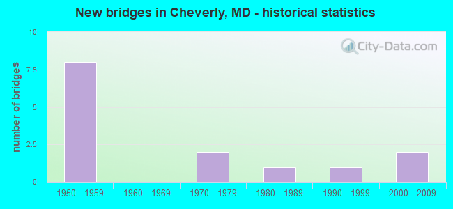
- New bridges - historical statistics
- 81950-1959
- 21970-1979
- 11980-1989
- 11990-1999
- 22000-2009

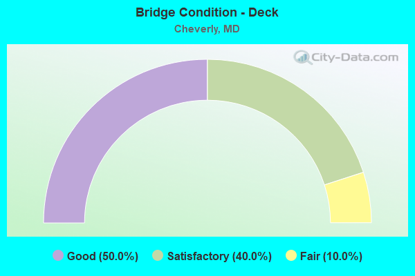
- Bridge Condition - Deck
- 50.0%Good
- 40.0%Satisfactory
- 10.0%Fair
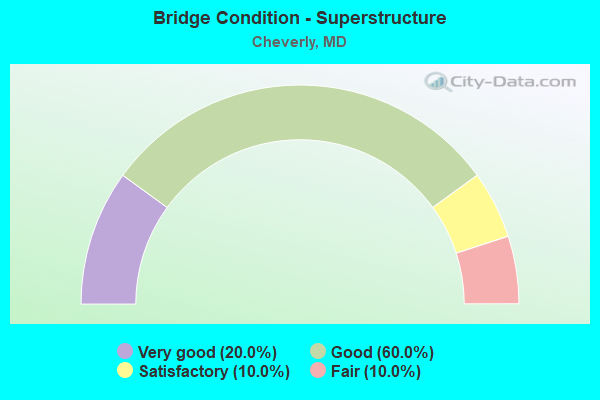
- Bridge Condition - Superstructure
- 20.0%Very good
- 60.0%Good
- 10.0%Satisfactory
- 10.0%Fair
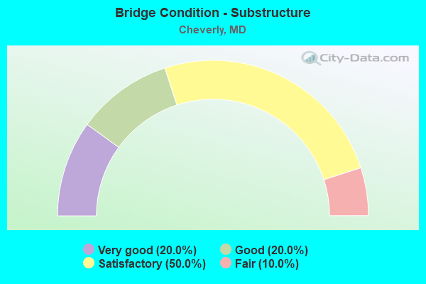
- Bridge Condition - Substructure
- 20.0%Very good
- 20.0%Good
- 50.0%Satisfactory
- 10.0%Fair
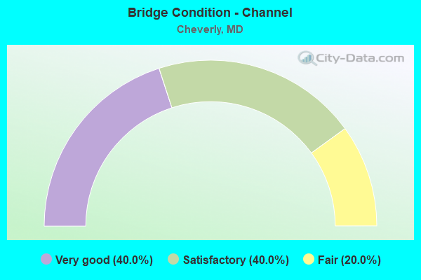
- Bridge Condition - Channel
- 40.0%Very good
- 40.0%Satisfactory
- 20.0%Fair
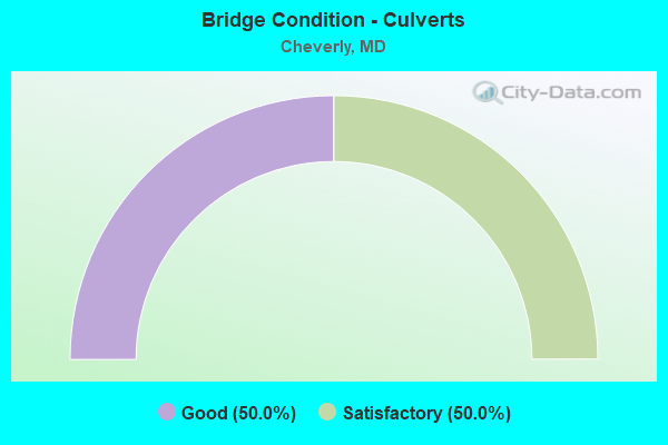
- Bridge Condition - Culverts
- 50.0%Good
- 50.0%Satisfactory
Find on map >> Show street view
Structure Number: 10000016002604, Location: 0.12 MILE NORTH OF MD 459 (Lat: 38.924342, Lng: -76.928928), Route carried "on" structure: State highway 201, Year Built: 1953, Status: Open, Structure Length: 1.43m (4.69ft), Average Daily Traffic: 32,080 (year 2009), Truck Traffic: 8%, Average Future Daily Traffic: 38,971 (year 2026), Design Load: HS 20, Features Intersected: CSX TRANS.
Minimum Vertical Clearance: 30+ m (98+ ft), Kilometerpoint: 1.512, Lanes on structure: 4, Base Highway Network: Yes, Owner: State Highway Agency, Approaching Roadway Width: 26.8m (87.9ft), Skew: 21 degrees, Material/Design: Concrete, Design/Construction: Frame, Number Of Spans In Main Unit: 1, Length of Maximum Span: 11.9m (39.0ft), Curb or Sidewalk Widths: Left: 1.5m (4.9ft), Right: 1.5m (4.9ft), Curb-To-Curb Width: 19.5m (64.0ft), Out-to-Out Width: 23.6m (77.4ft)
Condition: Deck: Good, Superstructure: Good, Substructure: Satisfactory, Operating Rating: 56.7 metric tons, Method Used To Determine Operating Rating: Load Factor (LF), Inventory Rating: 33.6 metric tons, Method Used To Determine Inventory Rating: Load Factor (LF), Structural Evaluation: Equal to present minimum criteria, Deck Geometry: Better than present minimum criteria, Underclear: Somewhat better than minimum adequacy, Approach Roadway Alignment: Equal to present desirable criteria, Designated Inspection Frequency: Every 24 months, Inspection Date: June 2021, Deck Structure Type: Concrete Cast-file-Place, Wearing Surface/Protective System: Wearing Surface: Monolithic Concrete
Find on map >> Show street view
Structure Number: 100000160028011, Location: 0.16 MILE SOUTH OF US 50 (Lat: 38.924672, Lng: -76.928633), Route carried "on" structure: State highway 201, Year Built: 2008, Status: Open, Structure Length: 8.69m (28.51ft), Average Daily Traffic: 132,060 (year 2009), Truck Traffic: 5%, Average Future Daily Traffic: 133,760 (year 2029), Design Load: HS 25 or greater, Features Intersected: AMTRAK,SER RD,BEAVERDAM
Minimum Vertical Clearance: 30+ m (98+ ft), Kilometerpoint: 0.547, Lanes on structure: 4, Lanes under structure: 2, Base Highway Network: Yes, Owner: State Highway Agency, Approaching Roadway Width: 20.7m (67.9ft), Material/Design: Steel, Design/Construction: Stringer/Multi-beam, Number Of Spans In Main Unit: 2, Length of Maximum Span: 42.7m (140.1ft), Curb-To-Curb Width: 20.7m (67.9ft), Out-to-Out Width: 21.9m (71.9ft)
Condition: Deck: Satisfactory, Superstructure: Very good, Substructure: Very good, Channel: Very good, Inventory Rating: 55.3 metric tons, Method Used To Determine Inventory Rating: Load Factor (LF), Structural Evaluation: Equal to present desirable criteria, Deck Geometry: Equal to present minimum criteria, Underclear: Equal to present desirable criteria, Waterway Adequacy: Equal to present desirable criteria, Approach Roadway Alignment: Equal to present desirable criteria, Designated Inspection Frequency: Every 24 months, Inspection Date: January 2021, Deck Structure Type: Concrete Cast-file-Place, Wearing Surface/Protective System: Wearing Surface: Integral Concrete, Deck Protection: Epoxy Coated Reinforcing
Find on map >> Show street view
Structure Number: 100000160028012, Location: 0.16 MILE SOUTH OF US 50 (Lat: 38.924894, Lng: -76.928658), Route carried "on" structure: State highway 201, Year Built: 2008, Status: Open, Structure Length: 8.87m (29.10ft), Average Daily Traffic: 132,060 (year 2009), Truck Traffic: 5%, Average Future Daily Traffic: 133,760 (year 2029), Design Load: HS 25 or greater, Features Intersected: AMTRAK,SER RD,BEAVERDAM
Minimum Vertical Clearance: 30+ m (98+ ft), Kilometerpoint: 0.547, Lanes on structure: 4, Lanes under structure: 2, Base Highway Network: Yes, Owner: State Highway Agency, Approaching Roadway Width: 20.7m (67.9ft), Material/Design: Steel, Design/Construction: Stringer/Multi-beam, Number Of Spans In Main Unit: 2, Length of Maximum Span: 22.6m (74.1ft), Curb-To-Curb Width: 20.7m (67.9ft), Out-to-Out Width: 21.9m (71.9ft)
Condition: Deck: Good, Superstructure: Very good, Substructure: Very good, Channel: Very good, Inventory Rating: 75.3 metric tons, Method Used To Determine Inventory Rating: Load Factor (LF), Structural Evaluation: Equal to present desirable criteria, Deck Geometry: Equal to present minimum criteria, Underclear: Equal to present desirable criteria, Waterway Adequacy: Equal to present desirable criteria, Approach Roadway Alignment: Equal to present desirable criteria, Designated Inspection Frequency: Every 24 months, Inspection Date: January 2021, Deck Structure Type: Concrete Cast-file-Place, Wearing Surface/Protective System: Wearing Surface: Bituminous
Find on map >> Show street view
Structure Number: 200000P-020802, Location: 0.1 MI. W OF JUTEWOOD AVE (Lat: 38.912069, Lng: -76.914869), Route carried "on" structure: County highway 540, Year Built: 1990, Status: Open, Structure Length: 0.67m (2.20ft), Average Daily Traffic: 724 (year 2017), Truck Traffic: 1%, Average Future Daily Traffic: 1,074 (year 2037), Features Intersected: BEAVERDAM CREEK, Facility Carried by Structure: NORTH ENGLEWOOD DR
Minimum Vertical Clearance: 30+ m (98+ ft), Kilometerpoint: 0.000, Lanes on structure: 2, Owner: County Highway Agency, Approaching Roadway Width: 10.1m (33.1ft), Skew: 3 degrees, Material/Design: Concrete, Design/Construction: Culvert, Number Of Spans In Main Unit: 2, Length of Maximum Span: 3.0m (9.8ft), Curb or Sidewalk Widths: Left: 1.2m (3.9ft), Right: 1.2m (3.9ft)
Condition: Channel: Fair, Culverts: Good, Operating Rating: 32.7 metric tons, Method Used To Determine Operating Rating: Field evaluation and documented engineering judgment, Inventory Rating: 32.7 metric tons, Method Used To Determine Inventory Rating: Field evaluation and documented engineering judgment, Structural Evaluation: Better than present minimum criteria, Waterway Adequacy: Somewhat better than minimum adequacy, Approach Roadway Alignment: Equal to present minimum criteria, Designated Inspection Frequency: Every 24 months, Inspection Date: March 2021
Find on map >> Show street view
Structure Number: 200000P-027501, Location: 125 FEET SOUTH OF US 50 (Lat: 38.916856, Lng: -76.914875), Route carried "on" structure: County highway 3668, Year Built: 1977, Year Reconstructed: 2003, Status: Open, Structure Length: 6.98m (22.90ft), Average Daily Traffic: 18,782 (year 2016), Truck Traffic: 7%, Average Future Daily Traffic: 27,909 (year 2036), Design Load: HS 25 or greater, Features Intersected: AMTRAK/WMATA/CSXT, Facility Carried by Structure: COLUMBIA PARK ROAD
Minimum Vertical Clearance: 30+ m (98+ ft), Kilometerpoint: 2.977, Lanes on structure: 3, Owner: County Highway Agency, Approaching Roadway Width: 16.5m (54.1ft), Material/Design: Steel continuous, Design/Construction: Stringer/Multi-beam, Number Of Spans In Main Unit: 3, Length of Maximum Span: 26.2m (86.0ft), Curb or Sidewalk Widths: Left: 0.0m, Right: 2.1m (6.9ft), Curb-To-Curb Width: 14.6m (47.9ft), Out-to-Out Width: 17.8m (58.4ft)
Condition: Deck: Satisfactory, Superstructure: Good, Substructure: Satisfactory, Inventory Rating: 59.9 metric tons, Method Used To Determine Inventory Rating: Load Factor (LF), Structural Evaluation: Equal to present minimum criteria, Deck Geometry: Somewhat better than minimum adequacy, Underclear: Better than present minimum criteria, Approach Roadway Alignment: Equal to present minimum criteria, Designated Inspection Frequency: Every 24 months, Inspection Date: March 2020, Deck Structure Type: Concrete Cast-file-Place, Wearing Surface/Protective System: Wearing Surface: Integral Concrete, Deck Protection: Epoxy Coated Reinforcing
Find on map >> Show street view
Structure Number: 200000P-028103, Location: 0.17 MI E OF US 50 (Lat: 38.916014, Lng: -76.913903), Route carried "on" structure: County highway 3668, Year Built: 1977, Status: Open, Structure Length: 3.29m (10.79ft), Average Daily Traffic: 27,778 (year 2017), Truck Traffic: 10%, Average Future Daily Traffic: 41,276 (year 2037), Design Load: HS 20, Features Intersected: BEAVERDAM CREEK, Facility Carried by Structure: COLUMBIA PARK ROAD
Minimum Vertical Clearance: 30+ m (98+ ft), Kilometerpoint: 2.800, Lanes on structure: 4, Owner: County Highway Agency, Approaching Roadway Width: 13.4m (44.0ft), Material/Design: Steel, Design/Construction: Culvert, Number Of Spans In Main Unit: 3, Length of Maximum Span: 9.8m (32.2ft), Curb or Sidewalk Widths: Left: 1.8m (5.9ft), Right: 1.2m (3.9ft)
Condition: Channel: Satisfactory, Culverts: Satisfactory, Operating Rating: 87.1 metric tons, Method Used To Determine Operating Rating: Load Factor (LF), Inventory Rating: 52.2 metric tons, Method Used To Determine Inventory Rating: Load Factor (LF), Structural Evaluation: Equal to present minimum criteria, Waterway Adequacy: Equal to present minimum criteria, Approach Roadway Alignment: Equal to present desirable criteria, Length Of Structure Improvement: 3.23m (10.60ft), Designated Inspection Frequency: Every 24 months, Inspection Date: March 2021, Bridge Improvement Cost: $2,000, Roadway Improvement Cost: $22,000, Total Project Cost: $24,000
Find on map >> Show street view
Structure Number: 200000P-CH2101, Location: 0.11 MI N OF STATE STREET (Lat: 38.915981, Lng: -76.911069), Route carried "on" structure: City street 641, Year Built: 1980, Year Reconstructed: 1996, Status: Open, Structure Length: 0.91m (2.99ft), Average Daily Traffic: 209 (year 2017), Truck Traffic: 1%, Average Future Daily Traffic: 309 (year 2037), Design Load: HS 20, Features Intersected: CABIN BRANCH, Facility Carried by Structure: 64TH AVENUE
Minimum Vertical Clearance: 30+ m (98+ ft), Kilometerpoint: 0.113, Lanes on structure: 2, Owner: Town or Township Highway Agency, Approaching Roadway Width: 7.3m (24.0ft), Material/Design: Prestressed concrete, Design/Construction: Box Beam or Girders - Multiple, Number Of Spans In Main Unit: 1, Length of Maximum Span: 8.5m (27.9ft), Curb or Sidewalk Widths: Left: 1.8m (5.9ft), Right: 0.0m, Curb-To-Curb Width: 6.8m (22.3ft), Out-to-Out Width: 9.4m (30.8ft)
Condition: Deck: Good, Superstructure: Good, Substructure: Good, Channel: Satisfactory, Operating Rating: 83.9 metric tons, Method Used To Determine Operating Rating: Load Factor (LF), Inventory Rating: 50.3 metric tons, Method Used To Determine Inventory Rating: Load Factor (LF), Structural Evaluation: Better than present minimum criteria, Deck Geometry: Meets minimum limits, Waterway Adequacy: Equal to present minimum criteria, Approach Roadway Alignment: Equal to present desirable criteria, Length Of Structure Improvement: 0.91m (2.99ft), Designated Inspection Frequency: Every 24 months, Inspection Date: April 2021, Wearing Surface/Protective System: Wearing Surface: Bituminous
Find on map >> Show street view
Structure Number: 3530017P, Location: 0.8 MILES NORTH OF MD ROU (Lat: 38.934250, Lng: -76.917833), Route carried "on" structure: Federal lands road 1, Year Built: 1953, Status: Open, Structure Length: 3.24m (10.63ft), Average Daily Traffic: 80,000 (year 2012), Truck Traffic: 1%, Average Future Daily Traffic: 88,000 (year 2032), Design Load: HS 20, Features Intersected: MD ROUTE 202, Facility Carried by Structure: BW PARKWAY
Minimum Vertical Clearance: 30+ m (98+ ft), Kilometerpoint: 2.900, Lanes on structure: 8, Lanes under structure: 6, Owner: National Park Service, Approaching Roadway Width: 33.7m (110.6ft), Skew: 31 degrees, Material/Design: Concrete continuous, Design/Construction: Frame, Number Of Spans In Main Unit: 2, Length of Maximum Span: 14.3m (46.9ft), Curb-To-Curb Width: 36.1m (118.4ft), Out-to-Out Width: 40.0m (131.2ft)
Condition: Deck: Satisfactory, Superstructure: Satisfactory, Substructure: Satisfactory, Inventory Rating: 62.6 metric tons, Method Used To Determine Inventory Rating: Load Factor (LF), Structural Evaluation: Equal to present minimum criteria, Deck Geometry: Better than present minimum criteria, Underclear: Meets minimum limits, Approach Roadway Alignment: Equal to present desirable criteria, Designated Inspection Frequency: Every 24 months, Inspection Date: Febuary 2020, Bridge Improvement Cost: $55,000, Roadway Improvement Cost: $6,000, Total Project Cost: $83,000 ( Estimate for 2018), Deck Structure Type: Concrete Cast-file-Place, Wearing Surface/Protective System: Wearing Surface: Bituminous
Find on map >> Show street view
Structure Number: 3530018P, Location: 0.8 MILES SOUTH OF MD ROU (Lat: 38.926778, Lng: -76.928250), Route carried "on" structure: Federal lands road 1, Year Built: 1953, Status: Open, Structure Length: 4.07m (13.35ft), Average Daily Traffic: 80,000 (year 2012), Truck Traffic: 1%, Average Future Daily Traffic: 88,000 (year 2032), Design Load: HS 20, Features Intersected: MD ROUTE 201, Facility Carried by Structure: BW PARKWAY
Minimum Vertical Clearance: 30+ m (98+ ft), Kilometerpoint: 1.550, Lanes on structure: 6, Lanes under structure: 4, Owner: National Park Service, Approaching Roadway Width: 28.0m (91.9ft), Skew: 33 degrees, Material/Design: Concrete continuous, Design/Construction: Frame, Number Of Spans In Main Unit: 2, Length of Maximum Span: 20.5m (67.3ft), Curb-To-Curb Width: 28.1m (92.2ft), Out-to-Out Width: 30.1m (98.8ft)
Condition: Deck: Good, Superstructure: Good, Substructure: Good, Operating Rating: 49.9 metric tons, Method Used To Determine Operating Rating: Load Factor (LF), Inventory Rating: 29.9 metric tons, Method Used To Determine Inventory Rating: Load Factor (LF), Structural Evaluation: Better than present minimum criteria, Deck Geometry: Equal to present minimum criteria, Underclear: Equal to present minimum criteria, Approach Roadway Alignment: Equal to present desirable criteria, Designated Inspection Frequency: Every 24 months, Inspection Date: Febuary 2020, Bridge Improvement Cost: $45,000, Roadway Improvement Cost: $5,000, Total Project Cost: $68,000 ( Estimate for 2018), Deck Structure Type: Concrete Cast-file-Place, Wearing Surface/Protective System: Wearing Surface: Bituminous
Find on map >> Show street view
Structure Number: 3530019P, Location: 0.1 MILES SOUTH OF MD ROU (Lat: 38.925583, Lng: -76.929556), Route carried "on" structure: Federal lands road 1, Year Built: 1953, Status: Open, Structure Length: 1.66m (5.45ft), Average Daily Traffic: 80,000 (year 2012), Truck Traffic: 1%, Average Future Daily Traffic: 88,000 (year 2032), Design Load: HS 20, Features Intersected: CSX RAILROAD, Facility Carried by Structure: BW PARKWAY
Minimum Vertical Clearance: 30+ m (98+ ft), Kilometerpoint: 1.370, Lanes on structure: 6, Owner: National Park Service, Approaching Roadway Width: 36.2m (118.8ft), Skew: 32 degrees, Material/Design: Concrete, Design/Construction: Frame, Number Of Spans In Main Unit: 1, Length of Maximum Span: 12.6m (41.3ft), Curb-To-Curb Width: 36.3m (119.1ft), Out-to-Out Width: 47.3m (155.2ft)
Condition: Deck: Good, Superstructure: Good, Substructure: Satisfactory, Inventory Rating: 68.0 metric tons, Method Used To Determine Inventory Rating: Load Factor (LF), Structural Evaluation: Equal to present minimum criteria, Deck Geometry: Superior to present desirable criteria, Underclear: Somewhat better than minimum adequacy, Approach Roadway Alignment: Equal to present desirable criteria, Designated Inspection Frequency: Every 24 months, Inspection Date: Febuary 2020, Bridge Improvement Cost: $25,000, Roadway Improvement Cost: $3,000, Total Project Cost: $38,000 ( Estimate for 2018), Deck Structure Type: Concrete Cast-file-Place, Wearing Surface/Protective System: Wearing Surface: Bituminous
Find on map >> Show street view
Structure Number: 3530020P, Location: 0.1 MILES NORTH OF U.S. R (Lat: 38.921250, Lng: -76.932500), Route carried "on" structure: Ramp Federal lands road 501, Year Built: 1954, Status: Open, Structure Length: 7.56m (24.80ft), Average Daily Traffic: 34,075 (year 2012), Truck Traffic: 1%, Average Future Daily Traffic: 40,000 (year 2032), Design Load: HS 20, Features Intersected: MD ROUTE 201, Facility Carried by Structure: BW PARKWAY ACCESS
Minimum Vertical Clearance: 30+ m (98+ ft), Kilometerpoint: 0.680, Lanes on structure: 2, Lanes under structure: 2, Owner: National Park Service, Approaching Roadway Width: 10.3m (33.8ft), Skew: 9 degrees, Material/Design: Steel, Design/Construction: Stringer/Multi-beam, Number Of Spans In Main Unit: 3, Length of Maximum Span: 34.6m (113.5ft), Curb-To-Curb Width: 10.5m (34.4ft), Out-to-Out Width: 11.1m (36.4ft)
Condition: Deck: Fair, Superstructure: Fair, Substructure: Fair, Operating Rating: 37.2 metric tons, Method Used To Determine Operating Rating: Load Factor (LF), Inventory Rating: 21.8 metric tons, Method Used To Determine Inventory Rating: Load Factor (LF), Structural Evaluation: Somewhat better than minimum adequacy, Deck Geometry: Better than present minimum criteria, Underclear: Better than present minimum criteria, Approach Roadway Alignment: Equal to present minimum criteria, Designated Inspection Frequency: Every 24 months, Inspection Date: Febuary 2020, Bridge Improvement Cost: $2,385,000, Roadway Improvement Cost: $239,000, Total Project Cost: $3,578,000 ( Estimate for 2018), Deck Structure Type: Concrete Cast-file-Place, Wearing Surface/Protective System: Wearing Surface: Monolithic Concrete
Find on map >> Show street view
Structure Number: 3530021P, Location: 0.6 MILES SOUTH OF MD ROU (Lat: 38.921139, Lng: -76.932889), Route carried "on" structure: Federal lands road 501, Year Built: 1954, Status: Open, Structure Length: 3.05m (10.01ft), Average Daily Traffic: 34,075 (year 2012), Truck Traffic: 1%, Average Future Daily Traffic: 40,000 (year 2032), Design Load: HS 20, Features Intersected: ACCESS RAMP TO BW PARKWA, Facility Carried by Structure: BW PARKWAY (SBL)
Minimum Vertical Clearance: 30+ m (98+ ft), Kilometerpoint: 0.630, Lanes on structure: 2, Lanes under structure: 2, Owner: National Park Service, Approaching Roadway Width: 8.5m (27.9ft), Skew: 5 degrees, Material/Design: Concrete, Design/Construction: Frame, Number Of Spans In Main Unit: 1, Length of Maximum Span: 24.5m (80.4ft), Curb-To-Curb Width: 9.4m (30.8ft), Out-to-Out Width: 10.9m (35.8ft)
Condition: Deck: Satisfactory, Superstructure: Good, Substructure: Satisfactory, Operating Rating: 33.6 metric tons, Method Used To Determine Operating Rating: Load Factor (LF), Inventory Rating: 20.0 metric tons, Method Used To Determine Inventory Rating: Load Factor (LF), Structural Evaluation: Somewhat better than minimum adequacy, Deck Geometry: High priority of replacement, Underclear: Equal to present minimum criteria, Approach Roadway Alignment: Equal to present desirable criteria, Designated Inspection Frequency: Every 24 months, Inspection Date: Febuary 2020, Bridge Improvement Cost: $350,000, Roadway Improvement Cost: $35,000, Total Project Cost: $525,000 ( Estimate for 2018), Deck Structure Type: Concrete Cast-file-Place, Wearing Surface/Protective System: Wearing Surface: Latex Concrete
Find on map >> Show street view
Structure Number: 10000016010601, Location: 1.41 MILES WEST OF MD 410 (Lat: 38.929003, Lng: -76.898825), Route carried "under" structure: US 50, Year Built: 1959, Structure Length: 0. m, Average Daily Traffic: 76,555 (year 2009), Features Intersected: US 50, Facility Carried by Structure: MD 202 RAMP 'E'
Minimum Vertical Clearance: 4.88m (16.01ft), Kilometerpoint: 4.328, Lanes on structure: 4, Lanes under structure: 6, Material/Design: Steel, Design/Construction: Stringer/Multi-beam, Length of Maximum Span: 24.7m (81.0ft)
Find on map >> Show street view
Structure Number: 10000016010714, Location: 0.44 MILE WEST OF MD 459 (Lat: 38.916908, Lng: -76.923739), Route carried "under" structure: US 50, Year Built: 1959, Structure Length: 0. m, Average Daily Traffic: 84,172 (year 2009), Features Intersected: US 50 & MD RTE 459, Facility Carried by Structure: CSX TRANSPORTATION
Minimum Vertical Clearance: 30+ m (98+ ft), Kilometerpoint: 1.607, Lanes under structure: 6, Material/Design: Steel, Design/Construction: Girder and Floorbeam System, Length of Maximum Span: 18.3m (60.0ft)