Bridge Statistics for Chester, Virginia (VA)
Condition, Traffic, Stress, Structural Evaluation, Project Costs
- National Bridge Inventory (NBI) Statistics
- 47Number of bridges
- 453ft / 138mTotal length
- $7,344,000Total costs
- 3,272,425Total average daily traffic
- 249,931Total average daily truck traffic
- National Bridge Inventory (NBI) Registered Bridges for Chester
- No street view available for this location
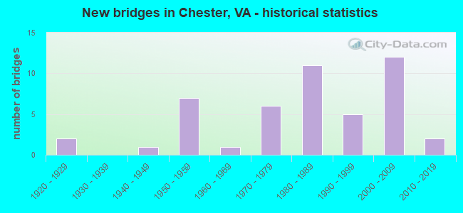
- New bridges - historical statistics
- 21920-1929
- 11940-1949
- 71950-1959
- 11960-1969
- 61970-1979
- 111980-1989
- 51990-1999
- 122000-2009
- 22010-2019


- Bridge Condition - Deck
- 53.8%Good
- 30.8%Satisfactory
- 11.5%Fair
- 3.8%Poor

- Bridge Condition - Superstructure
- 7.7%Very good
- 38.5%Good
- 26.9%Satisfactory
- 23.1%Fair
- 3.8%Poor

- Bridge Condition - Substructure
- 42.3%Good
- 23.1%Satisfactory
- 30.8%Fair
- 3.8%Poor

- Bridge Condition - Channel
- 33.3%Satisfactory
- 55.6%Fair
- 11.1%Poor

- Bridge Condition - Culverts
- 25.0%Good
- 75.0%Satisfactory
Find on map >> Show street view
Structure Number: 1441, Location: 1.73-Rt.623/1.70-Rt.776 (Lat: 37.500622, Lng: -78.956614), Route carried "on" structure: County highway 622, Year Built: 1953, Status: Posted for load, Structure Length: 0.76m (2.49ft), Average Daily Traffic: 117 (year 2020), Truck Traffic: 2%, Average Future Daily Traffic: 129 (year 2040), Features Intersected: Christian Mill Creek, Facility Carried by Structure: Stapleton Road
Minimum Vertical Clearance: 30+ m (98+ ft), Kilometerpoint: 20.869, Lanes on structure: 2, Owner: State Highway Agency, Approaching Roadway Width: 4.9m (16.1ft), Material/Design: Steel, Design/Construction: Stringer/Multi-beam, Number Of Spans In Main Unit: 1, Length of Maximum Span: 6.8m (22.3ft), Curb or Sidewalk Widths: Left: 0.2m (0.7ft), Right: 0.2m (0.7ft), Curb-To-Curb Width: 5.9m (19.4ft), Out-to-Out Width: 6.3m (20.7ft)
Condition: Deck: Good, Superstructure: Fair, Substructure: Satisfactory, Channel: Fair, Operating Rating: 34.5 metric tons, Method Used To Determine Operating Rating: Load Factor (LF), Inventory Rating: 20.9 metric tons, Method Used To Determine Inventory Rating: Load Factor (LF), Structural Evaluation: Somewhat better than minimum adequacy, Deck Geometry: High priority of corrective action, Waterway Adequacy: Somewhat better than minimum adequacy, Approach Roadway Alignment: Equal to present minimum criteria, Designated Inspection Frequency: Every 12 months, Inspection Date: January 2022, Deck Structure Type: Wood or Timber, Wearing Surface/Protective System: Wearing Surface: Bituminous
Find on map >> Show street view
Structure Number: 4994, Location: 0.60 Fr 746 & 1.15 To 859 (Lat: 37.321814, Lng: -77.405728), Route carried "on" structure: US 1, Year Built: 1928, Year Reconstructed: 2001, Status: Open, Structure Length: 0.66m (2.17ft), Average Daily Traffic: 13,666 (year 2020), Truck Traffic: 2%, Average Future Daily Traffic: 15,896 (year 2040), Design Load: HS 20+Mod, Features Intersected: ASHTON CREEK, Facility Carried by Structure: JEFF DAVIS HIGHWAY
Minimum Vertical Clearance: 30+ m (98+ ft), Kilometerpoint: 124.757, Lanes on structure: 5, Base Highway Network: Yes, Owner: State Highway Agency, Approaching Roadway Width: 18.6m (61.0ft), Skew: 3 degrees, Material/Design: Prestressed concrete, Design/Construction: Box Beam or Girders - Multiple, Number Of Spans In Main Unit: 1, Length of Maximum Span: 6.1m (20.0ft), Curb-To-Curb Width: 18.5m (60.7ft), Out-to-Out Width: 19.5m (64.0ft)
Condition: Deck: Satisfactory, Superstructure: Satisfactory, Substructure: Poor, Channel: Poor, Operating Rating: 71.7 metric tons, Method Used To Determine Operating Rating: Load and Resistance Factor (LRFR), Inventory Rating: 55.3 metric tons, Method Used To Determine Inventory Rating: Load and Resistance Factor (LRFR), Structural Evaluation: Meets minimum limits, Deck Geometry: High priority of corrective action, Waterway Adequacy: Meets minimum limits, Approach Roadway Alignment: Equal to present desirable criteria, Designated Inspection Frequency: Every 12 months, Underwater Inspection Frequency: Every 12 months, Inspection Date: August 2021, Underwater Inspection Date: August 2021, Deck Structure Type: Other, Wearing Surface/Protective System: Wearing Surface: Bituminous, Membrane: Epoxy, Deck Protection: Epoxy Coated Reinforcing
Find on map >> Show street view
Structure Number: 4995, Location: 0.57 Fr 619 & 0.40 To 620 (Lat: 37.299631, Lng: -77.409406), Route carried "on" structure: US 1, Year Built: 1928, Status: Open, Structure Length: 0.70m (2.30ft), Average Daily Traffic: 15,719 (year 2020), Truck Traffic: 2%, Average Future Daily Traffic: 17,635 (year 2040), Design Load: H 15, Features Intersected: TINSBERRY CREEK, Facility Carried by Structure: JEFF DAVIS HIGHWAY
Minimum Vertical Clearance: 30+ m (98+ ft), Kilometerpoint: 122.278, Lanes on structure: 4, Base Highway Network: Yes, Owner: State Highway Agency, Approaching Roadway Width: 14.2m (46.6ft), Material/Design: Concrete, Design/Construction: Slab, Number Of Spans In Main Unit: 1, Length of Maximum Span: 6.4m (21.0ft), Curb or Sidewalk Widths: Left: 0.2m (0.7ft), Right: 0.2m (0.7ft), Curb-To-Curb Width: 14.2m (46.6ft), Out-to-Out Width: 14.6m (47.9ft)
Condition: Deck: Fair, Superstructure: Fair, Substructure: Fair, Channel: Fair, Operating Rating: 39.0 metric tons, Method Used To Determine Operating Rating: Load Factor (LF), Inventory Rating: 23.6 metric tons, Method Used To Determine Inventory Rating: Load Factor (LF), Structural Evaluation: Somewhat better than minimum adequacy, Deck Geometry: High priority of replacement, Waterway Adequacy: Equal to present desirable criteria, Approach Roadway Alignment: Equal to present desirable criteria, Length Of Structure Improvement: 1.22m (4.00ft), Designated Inspection Frequency: Every 24 months, Underwater Inspection Frequency: Every 36 months, Inspection Date: November 2020, Underwater Inspection Date: November 2020, Bridge Improvement Cost: $540,000, Roadway Improvement Cost: $190,000, Total Project Cost: $876,000, Deck Structure Type: Concrete Cast-file-Place, Wearing Surface/Protective System: Wearing Surface: Bituminous
Find on map >> Show street view
Structure Number: 5, Location: .18 FR 144 & .1 TO 144 (Lat: 37.357136, Lng: -77.443656), Route carried "on" structure: State highway 10, Year Built: 1990, Status: Open, Structure Length: 4.39m (14.40ft), Average Daily Traffic: 28,629 (year 2020), Truck Traffic: 2%, Average Future Daily Traffic: 40,081 (year 2040), Design Load: HS 20+Mod, Features Intersected: CSX TRANSPORTATION, Facility Carried by Structure: WEST HUNDRED ROAD
Minimum Vertical Clearance: 30+ m (98+ ft), Kilometerpoint: 24.494, Lanes on structure: 4, Base Highway Network: Yes, Owner: State Highway Agency, Approaching Roadway Width: 19.8m (65.0ft), Skew: 1 degrees, Material/Design: Steel continuous, Design/Construction: Stringer/Multi-beam, Number Of Spans In Main Unit: 3, Length of Maximum Span: 19.8m (65.0ft), Curb or Sidewalk Widths: Left: 2.4m (7.9ft), Right: 2.4m (7.9ft), Curb-To-Curb Width: 19.5m (64.0ft), Out-to-Out Width: 25.0m (82.0ft)
Condition: Deck: Good, Superstructure: Good, Substructure: Good, Operating Rating: 89.8 metric tons, Method Used To Determine Operating Rating: Load and Resistance Factor (LRFR), Inventory Rating: 84.4 metric tons, Method Used To Determine Inventory Rating: Load and Resistance Factor (LRFR), Structural Evaluation: Better than present minimum criteria, Deck Geometry: Better than present minimum criteria, Underclear: Better than present minimum criteria, Approach Roadway Alignment: Equal to present desirable criteria, Designated Inspection Frequency: Every 24 months, Inspection Date: April 2020, Deck Structure Type: Concrete Cast-file-Place, Wearing Surface/Protective System: Deck Protection: Epoxy Coated Reinforcing
Find on map >> Show street view
Structure Number: 5051, Location: 0.40 Fr 620 & 2.40 To 10 (Lat: 37.316689, Lng: -77.400439), Route carried "on" structure: Interstate 95, Year Built: 1957, Status: Open, Structure Length: 1.07m (3.51ft), Average Daily Traffic: 90,488 (year 2020), Truck Traffic: 9%, Average Future Daily Traffic: 118,532 (year 2040), Design Load: HS 20, Features Intersected: ASHTON CREEK
Minimum Vertical Clearance: 30+ m (98+ ft), Kilometerpoint: 94.899, Lanes on structure: 6, Base Highway Network: Yes, Owner: State Highway Agency, Approaching Roadway Width: 34.1m (111.9ft), Skew: 2 degrees, Material/Design: Concrete, Design/Construction: Culvert, Number Of Spans In Main Unit: 3, Length of Maximum Span: 3.4m (11.2ft)
Condition: Channel: Fair, Culverts: Satisfactory, Operating Rating: 54.4 metric tons, Method Used To Determine Operating Rating: Field evaluation and documented engineering judgment, Inventory Rating: 32.7 metric tons, Method Used To Determine Inventory Rating: Field evaluation and documented engineering judgment, Structural Evaluation: Equal to present minimum criteria, Waterway Adequacy: Equal to present minimum criteria, Approach Roadway Alignment: Equal to present desirable criteria, Designated Inspection Frequency: Every 24 months, Inspection Date: July 2020
Find on map >> Show street view
Structure Number: 5055, Location: .86 FR 10 & .81 TO 288 (Lat: 37.366661, Lng: -77.403431), Route carried "on" structure: Interstate 95, Year Built: 1958, Status: Open, Structure Length: 2.34m (7.68ft), Average Daily Traffic: 112,354 (year 2020), Truck Traffic: 9%, Average Future Daily Traffic: 152,304 (year 2040), Design Load: HS 20, Features Intersected: RTE 616 (OSBORNE RD)
Minimum Vertical Clearance: 30+ m (98+ ft), Kilometerpoint: 100.144, Lanes on structure: 6, Lanes under structure: 2, Base Highway Network: Yes, Owner: State Highway Agency, Approaching Roadway Width: 36.0m (118.1ft), Skew: 31 degrees, Material/Design: Steel, Design/Construction: Stringer/Multi-beam, Number Of Spans In Main Unit: 1, Length of Maximum Span: 21.9m (71.9ft), Curb-To-Curb Width: 36.0m (118.1ft), Out-to-Out Width: 37.8m (124.0ft)
Condition: Deck: Fair, Superstructure: Satisfactory, Substructure: Fair, Operating Rating: 62.6 metric tons, Method Used To Determine Operating Rating: Load and Resistance Factor (LRFR), Inventory Rating: 48.1 metric tons, Method Used To Determine Inventory Rating: Load and Resistance Factor (LRFR), Structural Evaluation: Somewhat better than minimum adequacy, Deck Geometry: Superior to present desirable criteria, Underclear: Meets minimum limits, Approach Roadway Alignment: Equal to present desirable criteria, Designated Inspection Frequency: Every 24 months, Inspection Date: May 2021, Deck Structure Type: Concrete Cast-file-Place, Wearing Surface/Protective System: Wearing Surface: Bituminous
Find on map >> Show street view
Structure Number: 5086, Location: 3.05 Fr 620 & 1.61 To 288 (Lat: 37.354339, Lng: -77.404567), Route carried "on" structure: Interstate 95, Year Built: 1958, Year Reconstructed: 1996, Status: Open, Structure Length: 4.98m (16.34ft), Average Daily Traffic: 112,354 (year 2020), Truck Traffic: 8%, Average Future Daily Traffic: 152,304 (year 2040), Design Load: HS 20+Mod, Features Intersected: ROUTE 10
Minimum Vertical Clearance: 30+ m (98+ ft), Kilometerpoint: 98.760, Lanes on structure: 8, Lanes under structure: 6, Base Highway Network: Yes, Owner: State Highway Agency, Approaching Roadway Width: 43.6m (143.0ft), Skew: 30 degrees, Material/Design: Steel, Design/Construction: Stringer/Multi-beam, Number Of Spans In Main Unit: 4, Length of Maximum Span: 15.6m (51.2ft), Curb-To-Curb Width: 43.3m (142.1ft), Out-to-Out Width: 45.1m (148.0ft)
Condition: Deck: Satisfactory, Superstructure: Fair, Substructure: Fair, Operating Rating: 76.2 metric tons, Method Used To Determine Operating Rating: Load and Resistance Factor (LRFR), Inventory Rating: 58.1 metric tons, Method Used To Determine Inventory Rating: Load and Resistance Factor (LRFR), Structural Evaluation: Somewhat better than minimum adequacy, Deck Geometry: Superior to present desirable criteria, Underclear: Equal to present minimum criteria, Approach Roadway Alignment: Equal to present desirable criteria, Designated Inspection Frequency: Every 24 months, Inspection Date: March 2022, Deck Structure Type: Concrete Cast-file-Place, Wearing Surface/Protective System: Deck Protection: Epoxy Coated Reinforcing
Find on map >> Show street view
Structure Number: 509, Location: 0.85 FR 10 & 0.10 TO 616 (Lat: 37.366244, Lng: -77.403397), Route carried "on" structure: Interstate 95, Year Built: 1958, Status: Open, Structure Length: 6.10m (20.01ft), Average Daily Traffic: 112,354 (year 2020), Truck Traffic: 9%, Average Future Daily Traffic: 152,304 (year 2040), Design Load: HS 20, Features Intersected: REDWATER CREEK
Minimum Vertical Clearance: 30+ m (98+ ft), Kilometerpoint: 100.128, Lanes on structure: 6, Base Highway Network: Yes, Owner: State Highway Agency, Approaching Roadway Width: 28.0m (91.9ft), Material/Design: Concrete, Design/Construction: Culvert, Number Of Spans In Main Unit: 2, Length of Maximum Span: 3.0m (9.8ft)
Condition: Channel: Fair, Culverts: Satisfactory, Operating Rating: 89.8 metric tons, Method Used To Determine Operating Rating: Field evaluation and documented engineering judgment, Inventory Rating: 89.8 metric tons, Method Used To Determine Inventory Rating: Field evaluation and documented engineering judgment, Structural Evaluation: Equal to present minimum criteria, Waterway Adequacy: Equal to present minimum criteria, Approach Roadway Alignment: Equal to present desirable criteria, Designated Inspection Frequency: Every 24 months, Inspection Date: March 2022
Find on map >> Show street view
Structure Number: 51, Location: 1.51 FR 10 & .26 TO 145 (Lat: 37.377358, Lng: -77.452383), Route carried "on" structure: State highway 144, Year Built: 1949, Status: Open, Structure Length: 1.39m (4.56ft), Average Daily Traffic: 10,054 (year 2020), Truck Traffic: 2%, Average Future Daily Traffic: 12,383 (year 2040), Design Load: H 20, Features Intersected: GREAT BRANCH CREEK, Facility Carried by Structure: CHESTER ROAD
Minimum Vertical Clearance: 30+ m (98+ ft), Kilometerpoint: 22.063, Lanes on structure: 2, Owner: State Highway Agency, Approaching Roadway Width: 8.8m (28.9ft), Skew: 4 degrees, Material/Design: Concrete, Design/Construction: Tee Beam, Number Of Spans In Main Unit: 1, Length of Maximum Span: 12.5m (41.0ft), Curb or Sidewalk Widths: Left: 0.5m (1.6ft), Right: 0.5m (1.6ft), Curb-To-Curb Width: 7.3m (24.0ft), Out-to-Out Width: 7.8m (25.6ft)
Condition: Deck: Fair, Superstructure: Fair, Substructure: Satisfactory, Channel: Fair, Operating Rating: 46.0 metric tons, Method Used To Determine Operating Rating: Load and Resistance Factor (LRFR), Inventory Rating: 27.6 metric tons, Method Used To Determine Inventory Rating: Load and Resistance Factor (LRFR), Structural Evaluation: Somewhat better than minimum adequacy, Deck Geometry: High priority of replacement, Waterway Adequacy: Equal to present minimum criteria, Approach Roadway Alignment: Equal to present desirable criteria, Length Of Structure Improvement: 1.37m (4.49ft), Designated Inspection Frequency: Every 24 months, Inspection Date: September 2021, Bridge Improvement Cost: $270,000, Roadway Improvement Cost: $65,000, Total Project Cost: $345,000, Deck Structure Type: Concrete Cast-file-Place, Wearing Surface/Protective System: Wearing Surface: Bituminous
Find on map >> Show street view
Structure Number: 5171, Location: 0.01 Beg 288 & 1.04 To 1 (Lat: 37.377772, Lng: -77.408111), Route carried "on" structure: State highway 288, Year Built: 1989, Status: Open, Structure Length: 7.38m (24.21ft), Average Daily Traffic: 2,418 (year 2020), Truck Traffic: 4%, Average Future Daily Traffic: 3,387 (year 2040), Design Load: HS 20+Mod, Features Intersected: INTERSTATE-95
Minimum Vertical Clearance: 30+ m (98+ ft), Kilometerpoint: 0.016, Lanes on structure: 1, Lanes under structure: 7, Base Highway Network: Yes, Owner: State Highway Agency, Approaching Roadway Width: 9.4m (30.8ft), Skew: 1 degrees, Material/Design: Steel, Design/Construction: Stringer/Multi-beam, Number Of Spans In Main Unit: 2, Length of Maximum Span: 37.4m (122.7ft), Curb-To-Curb Width: 9.3m (30.5ft), Out-to-Out Width: 10.3m (33.8ft)
Condition: Deck: Good, Superstructure: Good, Substructure: Satisfactory, Inventory Rating: 73.5 metric tons, Method Used To Determine Inventory Rating: Load and Resistance Factor (LRFR), Structural Evaluation: Equal to present minimum criteria, Deck Geometry: Meets minimum limits, Underclear: Equal to present minimum criteria, Approach Roadway Alignment: Equal to present desirable criteria, Designated Inspection Frequency: Every 24 months, Inspection Date: December 2021, Deck Structure Type: Concrete Cast-file-Place, Wearing Surface/Protective System: Deck Protection: Epoxy Coated Reinforcing
Find on map >> Show street view
Structure Number: 5173, Location: 0.04 Beg 288 & 1.04 To 1 (Lat: 37.377917, Lng: -77.408267), Route carried "on" structure: State highway 288, Year Built: 1989, Status: Open, Structure Length: 7.38m (24.21ft), Average Daily Traffic: 6,430 (year 2020), Truck Traffic: 8%, Average Future Daily Traffic: 9,003 (year 2040), Design Load: HS 20+Mod, Features Intersected: INTERSTATE 95
Minimum Vertical Clearance: 30+ m (98+ ft), Kilometerpoint: 0.048, Lanes on structure: 1, Lanes under structure: 7, Base Highway Network: Yes, Owner: State Highway Agency, Approaching Roadway Width: 9.4m (30.8ft), Skew: 1 degrees, Material/Design: Steel, Design/Construction: Stringer/Multi-beam, Number Of Spans In Main Unit: 2, Length of Maximum Span: 37.4m (122.7ft), Curb-To-Curb Width: 9.3m (30.5ft), Out-to-Out Width: 10.3m (33.8ft)
Condition: Deck: Good, Superstructure: Good, Substructure: Satisfactory, Operating Rating: 84.4 metric tons, Method Used To Determine Operating Rating: Load and Resistance Factor (LRFR), Inventory Rating: 64.4 metric tons, Method Used To Determine Inventory Rating: Load and Resistance Factor (LRFR), Structural Evaluation: Equal to present minimum criteria, Deck Geometry: Meets minimum limits, Underclear: Equal to present minimum criteria, Approach Roadway Alignment: Equal to present desirable criteria, Designated Inspection Frequency: Every 24 months, Inspection Date: December 2021, Deck Structure Type: Concrete Cast-file-Place, Wearing Surface/Protective System: Wearing Surface: Epoxy Overlay, Deck Protection: Epoxy Coated Reinforcing
Find on map >> Show street view
Structure Number: 5175, Location: 0.56FRI-95&0.06TO1(301) (Lat: 37.376764, Lng: -77.418853), Route carried "on" structure: State highway 288, Year Built: 1989, Status: Open, Structure Length: 0.73m (2.40ft), Average Daily Traffic: 35,303 (year 2020), Truck Traffic: 5%, Average Future Daily Traffic: 49,424 (year 2040), Design Load: HS 20+Mod, Features Intersected: CATTLE RUN CREEK
Minimum Vertical Clearance: 30+ m (98+ ft), Kilometerpoint: 0.901, Lanes on structure: 5, Base Highway Network: Yes, Owner: State Highway Agency, Approaching Roadway Width: 12.2m (40.0ft), Skew: 24 degrees, Material/Design: Concrete, Design/Construction: Culvert, Number Of Spans In Main Unit: 2, Length of Maximum Span: 3.4m (11.2ft)
Condition: Channel: Poor, Culverts: Satisfactory, Operating Rating: 54.4 metric tons, Method Used To Determine Operating Rating: Field evaluation and documented engineering judgment, Inventory Rating: 32.7 metric tons, Method Used To Determine Inventory Rating: Field evaluation and documented engineering judgment, Structural Evaluation: Equal to present minimum criteria, Waterway Adequacy: Equal to present desirable criteria, Approach Roadway Alignment: Equal to present desirable criteria, Designated Inspection Frequency: Every 24 months, Inspection Date: September 2021
Find on map >> Show street view
Structure Number: 5176, Location: 1.0 FR I-95 & 1.78 TO 145 (Lat: 37.376803, Lng: -77.420006), Route carried "on" structure: State highway 288, Year Built: 1989, Status: Open, Structure Length: 5.74m (18.83ft), Average Daily Traffic: 17,651 (year 2020), Truck Traffic: 5%, Average Future Daily Traffic: 24,713 (year 2040), Design Load: HS 20+Mod, Features Intersected: ROUTE 1 (301)
Minimum Vertical Clearance: 30+ m (98+ ft), Kilometerpoint: 1.673, Lanes on structure: 3, Lanes under structure: 6, Base Highway Network: Yes, Owner: State Highway Agency, Approaching Roadway Width: 15.5m (50.9ft), Skew: 2 degrees, Material/Design: Steel continuous, Design/Construction: Stringer/Multi-beam, Number Of Spans In Main Unit: 2, Length of Maximum Span: 28.0m (91.9ft), Curb-To-Curb Width: 15.4m (50.5ft), Out-to-Out Width: 16.4m (53.8ft)
Condition: Deck: Good, Superstructure: Satisfactory, Substructure: Fair, Operating Rating: 68.0 metric tons, Method Used To Determine Operating Rating: Load and Resistance Factor (LRFR), Inventory Rating: 52.6 metric tons, Method Used To Determine Inventory Rating: Load and Resistance Factor (LRFR), Structural Evaluation: Somewhat better than minimum adequacy, Deck Geometry: Somewhat better than minimum adequacy, Underclear: Equal to present minimum criteria, Approach Roadway Alignment: Equal to present desirable criteria, Designated Inspection Frequency: Every 24 months, Inspection Date: October 2021, Deck Structure Type: Concrete Cast-file-Place, Wearing Surface/Protective System: Deck Protection: Epoxy Coated Reinforcing
Find on map >> Show street view
Structure Number: 5178, Location: 1.04 FR I-95 & 1.78 TO145 (Lat: 37.377053, Lng: -77.420094), Route carried "on" structure: State highway 288, Year Built: 1989, Status: Open, Structure Length: 5.74m (18.83ft), Average Daily Traffic: 17,651 (year 2020), Truck Traffic: 5%, Average Future Daily Traffic: 24,713 (year 2040), Design Load: HS 20+Mod, Features Intersected: ROUTE 1 (301)
Minimum Vertical Clearance: 30+ m (98+ ft), Kilometerpoint: 1.673, Lanes on structure: 3, Lanes under structure: 6, Base Highway Network: Yes, Owner: State Highway Agency, Approaching Roadway Width: 15.5m (50.9ft), Skew: 2 degrees, Material/Design: Steel continuous, Design/Construction: Stringer/Multi-beam, Number Of Spans In Main Unit: 2, Length of Maximum Span: 28.0m (91.9ft), Curb-To-Curb Width: 15.4m (50.5ft), Out-to-Out Width: 16.4m (53.8ft)
Condition: Deck: Good, Superstructure: Satisfactory, Substructure: Fair, Operating Rating: 68.9 metric tons, Method Used To Determine Operating Rating: Load and Resistance Factor (LRFR), Inventory Rating: 52.6 metric tons, Method Used To Determine Inventory Rating: Load and Resistance Factor (LRFR), Structural Evaluation: Somewhat better than minimum adequacy, Deck Geometry: Somewhat better than minimum adequacy, Underclear: Equal to present minimum criteria, Approach Roadway Alignment: Equal to present desirable criteria, Designated Inspection Frequency: Every 24 months, Inspection Date: October 2021, Deck Structure Type: Concrete Cast-file-Place, Wearing Surface/Protective System: Deck Protection: Epoxy Coated Reinforcing
Find on map >> Show street view
Structure Number: 5181, Location: 0.08 Fr 145 & 3.22 To 10 (Lat: 37.389967, Lng: -77.452525), Route carried "on" structure: State highway 288, Year Built: 1990, Status: Open, Structure Length: 4.24m (13.91ft), Average Daily Traffic: 19,185 (year 2020), Truck Traffic: 5%, Average Future Daily Traffic: 26,859 (year 2040), Design Load: HS 20+Mod, Features Intersected: CSX TRANSPORTATION
Minimum Vertical Clearance: 30+ m (98+ ft), Kilometerpoint: 5.004, Lanes on structure: 3, Base Highway Network: Yes, Owner: State Highway Agency, Approaching Roadway Width: 16.1m (52.8ft), Material/Design: Steel continuous, Design/Construction: Stringer/Multi-beam, Number Of Spans In Main Unit: 3, Length of Maximum Span: 15.8m (51.8ft), Curb-To-Curb Width: 16.1m (52.8ft), Out-to-Out Width: 17.1m (56.1ft)
Condition: Deck: Good, Superstructure: Good, Substructure: Good, Operating Rating: 89.8 metric tons, Method Used To Determine Operating Rating: Load and Resistance Factor (LRFR), Inventory Rating: 86.2 metric tons, Method Used To Determine Inventory Rating: Load and Resistance Factor (LRFR), Structural Evaluation: Better than present minimum criteria, Deck Geometry: Equal to present minimum criteria, Underclear: Somewhat better than minimum adequacy, Approach Roadway Alignment: Equal to present desirable criteria, Designated Inspection Frequency: Every 24 months, Inspection Date: May 2020, Deck Structure Type: Concrete Cast-file-Place, Wearing Surface/Protective System: Deck Protection: Epoxy Coated Reinforcing
Find on map >> Show street view
Structure Number: 5182, Location: 0.08 Fr 145 & 3.22 To 10 (Lat: 37.389744, Lng: -77.452658), Route carried "on" structure: State highway 288, Year Built: 1990, Status: Open, Structure Length: 4.24m (13.91ft), Average Daily Traffic: 19,185 (year 2020), Truck Traffic: 5%, Average Future Daily Traffic: 26,859 (year 2040), Design Load: HS 20+Mod, Features Intersected: CSX TRANSPORTATION
Minimum Vertical Clearance: 30+ m (98+ ft), Kilometerpoint: 5.004, Lanes on structure: 3, Base Highway Network: Yes, Owner: State Highway Agency, Approaching Roadway Width: 16.2m (53.1ft), Material/Design: Steel continuous, Design/Construction: Stringer/Multi-beam, Number Of Spans In Main Unit: 3, Length of Maximum Span: 15.8m (51.8ft), Curb-To-Curb Width: 16.1m (52.8ft), Out-to-Out Width: 17.1m (56.1ft)
Condition: Deck: Good, Superstructure: Good, Substructure: Good, Operating Rating: 89.8 metric tons, Method Used To Determine Operating Rating: Load and Resistance Factor (LRFR), Inventory Rating: 86.2 metric tons, Method Used To Determine Inventory Rating: Load and Resistance Factor (LRFR), Structural Evaluation: Better than present minimum criteria, Deck Geometry: Equal to present minimum criteria, Underclear: Somewhat better than minimum adequacy, Approach Roadway Alignment: Equal to present desirable criteria, Designated Inspection Frequency: Every 24 months, Inspection Date: May 2020, Deck Structure Type: Concrete Cast-file-Place, Wearing Surface/Protective System: Deck Protection: Epoxy Coated Reinforcing
Find on map >> Show street view
Structure Number: 5183, Location: 0.14 Fr 145 & 3.16 To 10 (Lat: 37.390586, Lng: -77.453889), Route carried "on" structure: State highway 288, Year Built: 1990, Status: Open, Structure Length: 5.24m (17.19ft), Average Daily Traffic: 19,185 (year 2020), Truck Traffic: 4%, Average Future Daily Traffic: 26,859 (year 2040), Design Load: HS 20+Mod, Features Intersected: CSX TRANSPORTATION
Minimum Vertical Clearance: 30+ m (98+ ft), Kilometerpoint: 5.101, Lanes on structure: 3, Base Highway Network: Yes, Owner: State Highway Agency, Approaching Roadway Width: 16.5m (54.1ft), Skew: 2 degrees, Material/Design: Steel continuous, Design/Construction: Stringer/Multi-beam, Number Of Spans In Main Unit: 3, Length of Maximum Span: 19.5m (64.0ft), Curb-To-Curb Width: 16.1m (52.8ft), Out-to-Out Width: 17.1m (56.1ft)
Condition: Deck: Good, Superstructure: Good, Substructure: Good, Operating Rating: 89.8 metric tons, Method Used To Determine Operating Rating: Load and Resistance Factor (LRFR), Inventory Rating: 80.7 metric tons, Method Used To Determine Inventory Rating: Load and Resistance Factor (LRFR), Structural Evaluation: Better than present minimum criteria, Deck Geometry: Equal to present minimum criteria, Underclear: Equal to present minimum criteria, Approach Roadway Alignment: Equal to present desirable criteria, Designated Inspection Frequency: Every 24 months, Inspection Date: May 2020, Deck Structure Type: Concrete Cast-file-Place, Wearing Surface/Protective System: Deck Protection: Epoxy Coated Reinforcing
Find on map >> Show street view
Structure Number: 5184, Location: 0.14 Fr 145 & 3.16 To 10 (Lat: 37.390306, Lng: -77.453897), Route carried "on" structure: State highway 288, Year Built: 1990, Status: Open, Structure Length: 5.24m (17.19ft), Average Daily Traffic: 19,185 (year 2020), Truck Traffic: 4%, Average Future Daily Traffic: 26,859 (year 2040), Design Load: HS 20+Mod, Features Intersected: CSX TRANSPORTATION
Minimum Vertical Clearance: 30+ m (98+ ft), Kilometerpoint: 5.101, Lanes on structure: 3, Base Highway Network: Yes, Owner: State Highway Agency, Approaching Roadway Width: 16.5m (54.1ft), Skew: 2 degrees, Material/Design: Steel continuous, Design/Construction: Stringer/Multi-beam, Number Of Spans In Main Unit: 3, Length of Maximum Span: 19.5m (64.0ft), Curb-To-Curb Width: 16.1m (52.8ft), Out-to-Out Width: 17.1m (56.1ft)
Condition: Deck: Good, Superstructure: Good, Substructure: Good, Operating Rating: 89.8 metric tons, Method Used To Determine Operating Rating: Load and Resistance Factor (LRFR), Inventory Rating: 80.7 metric tons, Method Used To Determine Inventory Rating: Load and Resistance Factor (LRFR), Structural Evaluation: Better than present minimum criteria, Deck Geometry: Equal to present minimum criteria, Underclear: Equal to present minimum criteria, Approach Roadway Alignment: Equal to present desirable criteria, Designated Inspection Frequency: Every 24 months, Inspection Date: May 2020, Deck Structure Type: Concrete Cast-file-Place, Wearing Surface/Protective System: Deck Protection: Epoxy Coated Reinforcing
Find on map >> Show street view
Structure Number: 5245, Location: 0.60 Fr 616 & 1.10 To 732 (Lat: 37.374308, Lng: -77.406506), Route carried "on" structure: County highway 615, Year Built: 1977, Status: Open, Structure Length: 5.61m (18.41ft), Average Daily Traffic: 1,056 (year 2020), Truck Traffic: 13%, Average Future Daily Traffic: 1,162 (year 2040), Design Load: HS 20+Mod, Features Intersected: INTERSTATE-95, Facility Carried by Structure: COXENDALE ROAD
Minimum Vertical Clearance: 30+ m (98+ ft), Kilometerpoint: 0.965, Lanes on structure: 2, Lanes under structure: 8, Owner: State Highway Agency, Approaching Roadway Width: 10.4m (34.1ft), Material/Design: Steel continuous, Design/Construction: Stringer/Multi-beam, Number Of Spans In Main Unit: 2, Length of Maximum Span: 27.4m (89.9ft), Curb-To-Curb Width: 10.4m (34.1ft), Out-to-Out Width: 11.6m (38.1ft)
Condition: Deck: Satisfactory, Superstructure: Fair, Substructure: Good, Operating Rating: 56.2 metric tons, Method Used To Determine Operating Rating: Load and Resistance Factor (LRFR), Inventory Rating: 43.5 metric tons, Method Used To Determine Inventory Rating: Load and Resistance Factor (LRFR), Structural Evaluation: Somewhat better than minimum adequacy, Deck Geometry: Equal to present minimum criteria, Underclear: High priority of corrective action, Approach Roadway Alignment: Equal to present desirable criteria, Designated Inspection Frequency: Every 24 months, Inspection Date: November 2021, Deck Structure Type: Concrete Cast-file-Place, Wearing Surface/Protective System: Wearing Surface: Epoxy Overlay
Find on map >> Show street view
Structure Number: 5254, Location: 0.64 FR 1 & 0.50 TO 620 (Lat: 37.299622, Lng: -77.405028), Route carried "on" structure: County highway 619, Year Built: 1971, Status: Open, Structure Length: 0.76m (2.49ft), Average Daily Traffic: 293 (year 2020), Truck Traffic: 9%, Average Future Daily Traffic: 302 (year 2040), Design Load: HS 20, Features Intersected: TINSBERRY CREEK, Facility Carried by Structure: HAPPY HILL ROAD
Minimum Vertical Clearance: 30+ m (98+ ft), Kilometerpoint: 1.030, Lanes on structure: 2, Owner: State Highway Agency, Approaching Roadway Width: 9.1m (29.9ft), Material/Design: Concrete, Design/Construction: Culvert, Number Of Spans In Main Unit: 3, Length of Maximum Span: 2.4m (7.9ft)
Condition: Channel: Fair, Culverts: Satisfactory, Operating Rating: 54.4 metric tons, Method Used To Determine Operating Rating: Field evaluation and documented engineering judgment, Inventory Rating: 32.7 metric tons, Method Used To Determine Inventory Rating: Field evaluation and documented engineering judgment, Structural Evaluation: Equal to present minimum criteria, Waterway Adequacy: Equal to present minimum criteria, Approach Roadway Alignment: Equal to present desirable criteria, Designated Inspection Frequency: Every 24 months, Inspection Date: July 2021
Find on map >> Show street view
Structure Number: 5261, Location: 1.71 FR 636 & .55 TO 634 (Lat: 37.322136, Lng: -77.525314), Route carried "on" structure: County highway 626, Year Built: 1977, Status: Open, Structure Length: 3.75m (12.30ft), Average Daily Traffic: 1,399 (year 2020), Truck Traffic: 4%, Average Future Daily Traffic: 1,959 (year 2040), Design Load: HS 20+Mod, Features Intersected: SECOND BRANCH, Facility Carried by Structure: WOODPECKER ROAD
Minimum Vertical Clearance: 30+ m (98+ ft), Kilometerpoint: 7.804, Lanes on structure: 2, Owner: State Highway Agency, Approaching Roadway Width: 8.5m (27.9ft), Skew: 1 degrees, Material/Design: Steel, Design/Construction: Stringer/Multi-beam, Number Of Spans In Main Unit: 3, Length of Maximum Span: 13.7m (44.9ft), Curb-To-Curb Width: 8.5m (27.9ft), Out-to-Out Width: 9.8m (32.2ft)
Condition: Deck: Satisfactory, Superstructure: Satisfactory, Substructure: Satisfactory, Channel: Fair, Operating Rating: 64.4 metric tons, Method Used To Determine Operating Rating: Load and Resistance Factor (LRFR), Inventory Rating: 49.0 metric tons, Method Used To Determine Inventory Rating: Load and Resistance Factor (LRFR), Structural Evaluation: Equal to present minimum criteria, Deck Geometry: Somewhat better than minimum adequacy, Waterway Adequacy: Equal to present desirable criteria, Approach Roadway Alignment: Equal to present desirable criteria, Designated Inspection Frequency: Every 24 months, Inspection Date: August 2021, Deck Structure Type: Concrete Cast-file-Place
Find on map >> Show street view
Structure Number: 5268, Location: 1.33 Fr 626 & 1.05 To 632 (Lat: 37.314619, Lng: -77.494731), Route carried "on" structure: County highway 631, Year Built: 1964, Status: Open, Structure Length: 4.36m (14.30ft), Average Daily Traffic: 5,537 (year 2020), Truck Traffic: 2%, Average Future Daily Traffic: 6,877 (year 2040), Design Load: HS 20+Mod, Features Intersected: SWIFT CREEK, Facility Carried by Structure: BRADLEY BRIDGE RD.
Minimum Vertical Clearance: 30+ m (98+ ft), Kilometerpoint: 5.862, Lanes on structure: 2, Base Highway Network: Yes, Owner: State Highway Agency, Approaching Roadway Width: 7.9m (25.9ft), Material/Design: Concrete, Design/Construction: Tee Beam, Number Of Spans In Main Unit: 3, Length of Maximum Span: 14.1m (46.3ft), Curb or Sidewalk Widths: Left: 0.3m (1.0ft), Right: 0.3m (1.0ft), Curb-To-Curb Width: 6.7m (22.0ft), Out-to-Out Width: 7.2m (23.6ft)
Condition: Deck: Satisfactory, Superstructure: Fair, Substructure: Fair, Channel: Fair, Operating Rating: 38.1 metric tons, Method Used To Determine Operating Rating: Load and Resistance Factor (LRFR), Inventory Rating: 29.0 metric tons, Method Used To Determine Inventory Rating: Load and Resistance Factor (LRFR), Structural Evaluation: Somewhat better than minimum adequacy, Deck Geometry: High priority of replacement, Waterway Adequacy: Equal to present desirable criteria, Approach Roadway Alignment: Equal to present desirable criteria, Length Of Structure Improvement: 4.36m (14.30ft), Designated Inspection Frequency: Every 24 months, Inspection Date: August 2020, Bridge Improvement Cost: $1,578,000, Roadway Improvement Cost: $380,000, Total Project Cost: $2,545,000, Deck Structure Type: Concrete Cast-file-Place
Find on map >> Show street view
Structure Number: 5309, Location: 0.15 FR 636 & 0.84 TO 10 (Lat: 37.367806, Lng: -77.518036), Route carried "on" structure: County highway 655, Year Built: 1972, Status: Open, Structure Length: 5.33m (17.49ft), Average Daily Traffic: 13,156 (year 2020), Truck Traffic: 3%, Average Future Daily Traffic: 18,418 (year 2040), Design Load: HS 20+Mod, Features Intersected: SWIFT CREEK, Facility Carried by Structure: BEACH ROAD
Minimum Vertical Clearance: 30+ m (98+ ft), Kilometerpoint: 21.995, Lanes on structure: 2, Owner: State Highway Agency, Approaching Roadway Width: 10.1m (33.1ft), Skew: 3 degrees, Material/Design: Steel, Design/Construction: Stringer/Multi-beam, Number Of Spans In Main Unit: 3, Length of Maximum Span: 18.0m (59.1ft), Curb-To-Curb Width: 9.1m (29.9ft), Out-to-Out Width: 10.4m (34.1ft)
Condition: Deck: Satisfactory, Superstructure: Satisfactory, Substructure: Fair, Channel: Satisfactory, Operating Rating: 66.2 metric tons, Method Used To Determine Operating Rating: Load and Resistance Factor (LRFR), Inventory Rating: 50.8 metric tons, Method Used To Determine Inventory Rating: Load and Resistance Factor (LRFR), Structural Evaluation: Somewhat better than minimum adequacy, Deck Geometry: High priority of corrective action, Waterway Adequacy: Equal to present desirable criteria, Approach Roadway Alignment: Equal to present desirable criteria, Length Of Structure Improvement: 5.33m (17.49ft), Designated Inspection Frequency: Every 24 months, Inspection Date: May 2020, Bridge Improvement Cost: $2,677,000, Roadway Improvement Cost: $75,000, Total Project Cost: $3,578,000, Deck Structure Type: Concrete Cast-file-Place
Find on map >> Show street view
Structure Number: 25381, Location: 0.84 FR 1 & 0.20 TO 746 (Lat: 37.311025, Lng: -77.398278), Route carried "on" structure: County highway 620, Year Built: 2001, Status: Open, Structure Length: 9.06m (29.72ft), Average Daily Traffic: 15,577 (year 2020), Truck Traffic: 2%, Average Future Daily Traffic: 20,060 (year 2040), Design Load: HS 20+Mod, Features Intersected: Rt 95 & LOOP A FR Rt 620, Facility Carried by Structure: WOODS EDGE ROAD
Minimum Vertical Clearance: 30+ m (98+ ft), Kilometerpoint: 1.352, Lanes on structure: 5, Lanes under structure: 8, Owner: State Highway Agency, Approaching Roadway Width: 24.7m (81.0ft), Skew: 20 degrees, Material/Design: Steel continuous, Design/Construction: Stringer/Multi-beam, Number Of Spans In Main Unit: 2, Length of Maximum Span: 45.7m (149.9ft), Curb-To-Curb Width: 29.4m (96.5ft), Out-to-Out Width: 30.4m (99.7ft)
Condition: Deck: Good, Superstructure: Good, Substructure: Good, Operating Rating: 62.6 metric tons, Method Used To Determine Operating Rating: Load and Resistance Factor (LRFR), Inventory Rating: 48.1 metric tons, Method Used To Determine Inventory Rating: Load and Resistance Factor (LRFR), Structural Evaluation: Better than present minimum criteria, Deck Geometry: Superior to present desirable criteria, Underclear: Meets minimum limits, Approach Roadway Alignment: Equal to present desirable criteria, Designated Inspection Frequency: Every 24 months, Inspection Date: June 2021, Deck Structure Type: Concrete Cast-file-Place, Wearing Surface/Protective System: Deck Protection: Epoxy Coated Reinforcing
Find on map >> Show street view
Structure Number: 25382, Location: 0.26 Fr 1 & 0.41 To 620 (Lat: 37.314261, Lng: -77.404297), Route carried "on" structure: County highway 746, Year Built: 2001, Status: Open, Structure Length: 5.80m (19.03ft), Average Daily Traffic: 5,971 (year 2020), Truck Traffic: 3%, Average Future Daily Traffic: 8,359 (year 2040), Design Load: HS 20+Mod, Features Intersected: CSX TRANSPORTATION, Facility Carried by Structure: RUFFIN MILL ROAD
Minimum Vertical Clearance: 30+ m (98+ ft), Kilometerpoint: 0.418, Lanes on structure: 2, Owner: State Highway Agency, Approaching Roadway Width: 13.2m (43.3ft), Skew: 3 degrees, Material/Design: Steel continuous, Design/Construction: Stringer/Multi-beam, Number Of Spans In Main Unit: 3, Length of Maximum Span: 25.3m (83.0ft), Curb-To-Curb Width: 13.2m (43.3ft), Out-to-Out Width: 14.2m (46.6ft)
Condition: Deck: Good, Superstructure: Good, Substructure: Good, Operating Rating: 55.3 metric tons, Method Used To Determine Operating Rating: Load and Resistance Factor (LRFR), Inventory Rating: 42.6 metric tons, Method Used To Determine Inventory Rating: Load and Resistance Factor (LRFR), Structural Evaluation: Better than present minimum criteria, Deck Geometry: Somewhat better than minimum adequacy, Underclear: Equal to present desirable criteria, Approach Roadway Alignment: Equal to present desirable criteria, Designated Inspection Frequency: Every 24 months, Inspection Date: June 2021, Deck Structure Type: Concrete Cast-file-Place, Wearing Surface/Protective System: Deck Protection: Epoxy Coated Reinforcing
Find on map >> Show street view
Structure Number: 25383, Location: 0.45 FR 1 & 0.22 TO 620 (Lat: 37.313906, Lng: -77.400125), Route carried "on" structure: County highway 746, Year Built: 2001, Status: Open, Structure Length: 11.22m (36.81ft), Average Daily Traffic: 5,971 (year 2020), Truck Traffic: 2%, Average Future Daily Traffic: 8,359 (year 2040), Design Load: HS 20+Mod, Features Intersected: RTE 95 & RAMP C & LOOP B, Facility Carried by Structure: RUFFIN MILL ROAD
Minimum Vertical Clearance: 30+ m (98+ ft), Kilometerpoint: 0.724, Lanes on structure: 2, Lanes under structure: 8, Owner: State Highway Agency, Approaching Roadway Width: 13.1m (43.0ft), Skew: 2 degrees, Material/Design: Steel continuous, Design/Construction: Stringer/Multi-beam, Number Of Spans In Main Unit: 4, Length of Maximum Span: 29.6m (97.1ft), Curb-To-Curb Width: 13.2m (43.3ft), Out-to-Out Width: 14.2m (46.6ft)
Condition: Deck: Good, Superstructure: Very good, Substructure: Good, Operating Rating: 37.2 metric tons, Method Used To Determine Operating Rating: Load and Resistance Factor (LRFR), Inventory Rating: 28.1 metric tons, Method Used To Determine Inventory Rating: Load and Resistance Factor (LRFR), Structural Evaluation: Better than present minimum criteria, Deck Geometry: Somewhat better than minimum adequacy, Underclear: High priority of corrective action, Approach Roadway Alignment: Equal to present desirable criteria, Designated Inspection Frequency: Every 24 months, Inspection Date: June 2021, Deck Structure Type: Concrete Cast-file-Place, Wearing Surface/Protective System: Deck Protection: Epoxy Coated Reinforcing
Find on map >> Show street view
Structure Number: 25384, Location: 0.10 FR 746 & 1.72 TO 818 (Lat: 37.314053, Lng: -77.395839), Route carried "on" structure: County highway 620, Year Built: 2001, Status: Open, Structure Length: 12.60m (41.34ft), Average Daily Traffic: 7,037 (year 2020), Truck Traffic: 4%, Average Future Daily Traffic: 9,852 (year 2040), Design Load: HS 20+Mod, Features Intersected: ASHTON CREEK, Facility Carried by Structure: WOODS EDGE ROAD
Minimum Vertical Clearance: 30+ m (98+ ft), Kilometerpoint: 1.754, Lanes on structure: 6, Owner: State Highway Agency, Approaching Roadway Width: 28.3m (92.8ft), Skew: 20 degrees, Material/Design: Prestressed concrete continuous, Design/Construction: Stringer/Multi-beam, Number Of Spans In Main Unit: 6, Length of Maximum Span: 20.0m (65.6ft), Curb-To-Curb Width: 29.4m (96.5ft), Out-to-Out Width: 30.4m (99.7ft)
Condition: Deck: Satisfactory, Superstructure: Good, Substructure: Satisfactory, Channel: Satisfactory, Operating Rating: 44.5 metric tons, Method Used To Determine Operating Rating: Load and Resistance Factor (LRFR), Inventory Rating: 34.5 metric tons, Method Used To Determine Inventory Rating: Load and Resistance Factor (LRFR), Structural Evaluation: Equal to present minimum criteria, Deck Geometry: Superior to present desirable criteria, Waterway Adequacy: Better than present minimum criteria, Approach Roadway Alignment: Equal to present desirable criteria, Designated Inspection Frequency: Every 24 months, Inspection Date: June 2021, Deck Structure Type: Concrete Cast-file-Place, Wearing Surface/Protective System: Deck Protection: Epoxy Coated Reinforcing
Find on map >> Show street view
Structure Number: 28291, Location: .05 FR 5146 &.1 T DEADEND (Lat: 37.522775, Lng: -77.683656), Route carried "on" structure: County highway 5147, Year Built: 2005, Status: Open, Structure Length: 0.91m (2.99ft), Average Daily Traffic: 116 (year 2016), Average Future Daily Traffic: 130 (year 2040), Design Load: HS 20, Features Intersected: BRANCH OF MICHAUX BRANCH, Facility Carried by Structure: LASTINGHAM DRIVE
Minimum Vertical Clearance: 30+ m (98+ ft), Kilometerpoint: 0.451, Lanes on structure: 2, Owner: State Highway Agency, Approaching Roadway Width: 8.8m (28.9ft), Material/Design: Concrete, Design/Construction: Frame, Number Of Spans In Main Unit: 1, Length of Maximum Span: 8.5m (27.9ft), Curb-To-Curb Width: 8.8m (28.9ft), Out-to-Out Width: 18.3m (60.0ft)
Condition: Deck: Satisfactory, Superstructure: Satisfactory, Substructure: Good, Channel: Satisfactory, Operating Rating: 96.3 metric tons, Method Used To Determine Operating Rating: Load Factor (LF), Inventory Rating: 56.8 metric tons, Method Used To Determine Inventory Rating: Load Factor (LF), Structural Evaluation: Equal to present minimum criteria, Deck Geometry: Equal to present minimum criteria, Waterway Adequacy: Superior to present desirable criteria, Approach Roadway Alignment: Equal to present desirable criteria, Designated Inspection Frequency: Every 24 months, Inspection Date: March 2022
Find on map >> Show street view
Structure Number: 28486, Location: 2.30 Fr 636 & 0.10 To5186 (Lat: 37.330189, Lng: -77.517172), Route carried "on" structure: County highway 5160, Year Built: 2004, Status: Open, Structure Length: 0.79m (2.59ft), Average Daily Traffic: 1,452 (year 2016), Average Future Daily Traffic: 1,626 (year 2040), Design Load: HS 20+Mod, Features Intersected: LICKING CREEK, Facility Carried by Structure: HIGHLAND GLEN DRVE
Minimum Vertical Clearance: 30+ m (98+ ft), Kilometerpoint: 0.000, Lanes on structure: 2, Owner: State Highway Agency, Approaching Roadway Width: 12.8m (42.0ft), Material/Design: Concrete, Design/Construction: Culvert, Number Of Spans In Main Unit: 2, Length of Maximum Span: 3.7m (12.1ft)
Condition: Channel: Fair, Culverts: Satisfactory, Operating Rating: 89.8 metric tons, Method Used To Determine Operating Rating: Field evaluation and documented engineering judgment, Inventory Rating: 89.8 metric tons, Method Used To Determine Inventory Rating: Field evaluation and documented engineering judgment, Structural Evaluation: Equal to present minimum criteria, Waterway Adequacy: Equal to present desirable criteria, Approach Roadway Alignment: Equal to present desirable criteria, Designated Inspection Frequency: Every 24 months, Inspection Date: November 2020
Find on map >> Show street view
Structure Number: 28487, Location: 0.80 FR 626 & 2.10 TO 636 (Lat: 37.328769, Lng: -77.516253), Route carried "on" structure: County highway 5186, Year Built: 2004, Status: Open, Structure Length: 1.55m (5.09ft), Average Daily Traffic: 987 (year 2016), Average Future Daily Traffic: 1,105 (year 2040), Design Load: HS 20+Mod, Features Intersected: LICKING CREEK, Facility Carried by Structure: EASTFAIR DRIVE
Minimum Vertical Clearance: 30+ m (98+ ft), Kilometerpoint: 0.000, Lanes on structure: 2, Owner: State Highway Agency, Approaching Roadway Width: 10.7m (35.1ft), Material/Design: Concrete, Design/Construction: Culvert, Number Of Spans In Main Unit: 2, Length of Maximum Span: 7.3m (24.0ft)
Condition: Channel: Fair, Culverts: Satisfactory, Operating Rating: 54.4 metric tons, Method Used To Determine Operating Rating: Field evaluation and documented engineering judgment, Inventory Rating: 32.7 metric tons, Method Used To Determine Inventory Rating: Field evaluation and documented engineering judgment, Structural Evaluation: Equal to present minimum criteria, Waterway Adequacy: Equal to present desirable criteria, Approach Roadway Alignment: Equal to present desirable criteria, Designated Inspection Frequency: Every 24 months, Inspection Date: November 2020
Find on map >> Show street view
Structure Number: 29316, Location: 0.05 Fr 732 & 1.92 To 618 (Lat: 37.353383, Lng: -77.395447), Route carried "on" structure: US 10, Year Built: 2012, Status: Open, Structure Length: 3.83m (12.57ft), Average Daily Traffic: 48,182 (year 2020), Truck Traffic: 6%, Average Future Daily Traffic: 64,066 (year 2040), Design Load: HS 20+Mod, Features Intersected: CSX TRANSPORTATION, Facility Carried by Structure: WEST HUNDRED ROAD
Minimum Vertical Clearance: 30+ m (98+ ft), Kilometerpoint: 0.000, Lanes on structure: 9, Base Highway Network: Yes, Owner: State Highway Agency, Approaching Roadway Width: 44.7m (146.7ft), Skew: 23 degrees, Material/Design: Steel, Design/Construction: Stringer/Multi-beam, Number Of Spans In Main Unit: 1, Length of Maximum Span: 37.5m (123.0ft), Curb or Sidewalk Widths: Left: 2.4m (7.9ft), Right: 2.4m (7.9ft), Curb-To-Curb Width: 39.0m (128.0ft), Out-to-Out Width: 44.7m (146.7ft)
Condition: Deck: Good, Superstructure: Very good, Substructure: Good, Operating Rating: 83.3 metric tons, Method Used To Determine Operating Rating: Load and Resistance Factor (LRFR), Inventory Rating: 64.2 metric tons, Method Used To Determine Inventory Rating: Load and Resistance Factor (LRFR), Structural Evaluation: Better than present minimum criteria, Deck Geometry: Superior to present desirable criteria, Underclear: Superior to present desirable criteria, Approach Roadway Alignment: Equal to present desirable criteria, Designated Inspection Frequency: Every 24 months, Inspection Date: June 2021, Deck Structure Type: Concrete Cast-file-Place, Wearing Surface/Protective System: Wearing Surface: Epoxy Overlay, Deck Protection: Epoxy Coated Reinforcing
Find on map >> Show street view
Structure Number: 31007, Location: 0.1Fr10&0.2toWeatherby (Lat: 37.352389, Lng: -77.463194), Route carried "on" structure: County highway 7952, Year Built: 2017, Status: Open, Structure Length: 0.67m (2.20ft), Average Daily Traffic: 11,638 (year 2014), Average Future Daily Traffic: 15,304 (year 2035), Design Load: HS 20+Mod, Features Intersected: UNNAMED TRIBUTARY, Facility Carried by Structure: IRON RIVER ROAD
Minimum Vertical Clearance: 30+ m (98+ ft), Kilometerpoint: 0.000, Lanes on structure: 2, Owner: State Highway Agency, Approaching Roadway Width: 7.3m (24.0ft), Design/Construction: Culvert, Number Of Spans In Main Unit: 1, Length of Maximum Span: 1.8m (5.9ft), Curb or Sidewalk Widths: Left: 0.6m (2.0ft), Right: 2.1m (6.9ft)
Condition: Channel: Satisfactory, Culverts: Good, Operating Rating: 89.8 metric tons, Method Used To Determine Operating Rating: Field evaluation and documented engineering judgment, Inventory Rating: 89.8 metric tons, Method Used To Determine Inventory Rating: Field evaluation and documented engineering judgment, Structural Evaluation: Better than present minimum criteria, Waterway Adequacy: Equal to present minimum criteria, Approach Roadway Alignment: Equal to present minimum criteria, Designated Inspection Frequency: Every 24 months, Inspection Date: August 2021
Find on map >> Show street view
Structure Number: 31138, Location: .05FRRTE4933&.05TORTE4930 (Lat: 37.322417, Lng: -77.444028), Route carried "on" structure: County highway 4932, Year Built: 1989, Status: Open, Structure Length: 1.55m (5.09ft), Average Daily Traffic: 820 (year 2017), Average Future Daily Traffic: 818 (year 2035), Design Load: HS 20, Features Intersected: TINSBERRY CREEK, Facility Carried by Structure: TWIN CEDAR RD
Minimum Vertical Clearance: 30+ m (98+ ft), Kilometerpoint: 0.000, Lanes on structure: 2, Owner: State Highway Agency, Approaching Roadway Width: 7.3m (24.0ft), Material/Design: Steel, Design/Construction: Culvert, Number Of Spans In Main Unit: 1, Length of Maximum Span: 2.3m (7.5ft)
Condition: Channel: Satisfactory, Culverts: Good, Operating Rating: 44.5 metric tons, Method Used To Determine Operating Rating: Field evaluation and documented engineering judgment, Inventory Rating: 32.7 metric tons, Method Used To Determine Inventory Rating: Field evaluation and documented engineering judgment, Structural Evaluation: Better than present minimum criteria, Waterway Adequacy: Equal to present desirable criteria, Approach Roadway Alignment: Equal to present desirable criteria, Designated Inspection Frequency: Every 24 months, Inspection Date: June 2020
Find on map >> Show street view
Structure Number: 31139, Location: 0.05FR4939&0.05TO4930 (Lat: 37.324231, Lng: -77.445958), Route carried "on" structure: City street 4943, Year Built: 1989, Status: Posted for load, Structure Length: 1.55m (5.09ft), Average Daily Traffic: 720 (year 2020), Average Future Daily Traffic: 712 (year 2035), Design Load: HS 15, Features Intersected: TIMSBERRY CREEK, Facility Carried by Structure: CEDAR CLIFF DR
Minimum Vertical Clearance: 30+ m (98+ ft), Kilometerpoint: 0.000, Lanes on structure: 2, Owner: State Highway Agency, Approaching Roadway Width: 6.7m (22.0ft), Material/Design: Steel, Design/Construction: Arch - Deck, Number Of Spans In Main Unit: 4, Length of Maximum Span: 3.7m (12.1ft), Curb-To-Curb Width: 9.4m (30.8ft), Out-to-Out Width: 12.8m (42.0ft)
Condition: Deck: Poor, Superstructure: Poor, Substructure: Fair, Channel: Satisfactory, Operating Rating: 12.7 metric tons, Method Used To Determine Operating Rating: Field evaluation and documented engineering judgment, Inventory Rating: 7.3 metric tons, Method Used To Determine Inventory Rating: Field evaluation and documented engineering judgment, Structural Evaluation: High priority of corrective action, Deck Geometry: Equal to present minimum criteria, Waterway Adequacy: Equal to present desirable criteria, Approach Roadway Alignment: Equal to present desirable criteria, Bridge Posting: Required (Relationship of Operating Rating to Maximum Legal Load: > 39.9% below), Designated Inspection Frequency: Every 12 months, Inspection Date: June 2021, Deck Structure Type: Other
Find on map >> Show street view
Structure Number: 5055, Location: .86 FR 10 & .81 TO 288 (Lat: 37.366661, Lng: -77.403431), Route carried "under" structure: County highway 616, Year Built: 1958, Structure Length: 0. m, Average Daily Traffic: 2,600 (year 2019), Truck Traffic: 1%, Features Intersected: RTE 616 (OSBORNE RD), Facility Carried by Structure: ROUTE 0095
Minimum Vertical Clearance: 4.57m (14.99ft), Kilometerpoint: 6.710, Lanes on structure: 6, Lanes under structure: 2, Material/Design: Steel, Design/Construction: Stringer/Multi-beam, Length of Maximum Span: 21.9m (71.9ft)
Find on map >> Show street view
Structure Number: 5086, Location: 3.05 Fr 620 & 1.61 To 288 (Lat: 37.354339, Lng: -77.404567), Route carried "under" structure: State highway 10, Year Built: 1958, Structure Length: 0. m, Average Daily Traffic: 52,000 (year 2018), Truck Traffic: 5%, Features Intersected: ROUTE 10, Facility Carried by Structure: I-95
Minimum Vertical Clearance: 4.60m (15.09ft), Kilometerpoint: 28.125, Lanes on structure: 8, Lanes under structure: 6, Material/Design: Steel, Design/Construction: Stringer/Multi-beam, Length of Maximum Span: 15.6m (51.2ft)
Find on map >> Show street view
Structure Number: 5171, Location: 0.01 Beg 288 & 1.04 To 1 (Lat: 37.377772, Lng: -77.408111), Route carried "under" structure: Interstate 95, Year Built: 1989, Structure Length: 0. m, Average Daily Traffic: 999,999 (year 2018), Truck Traffic: 8%, Features Intersected: INTERSTATE-95, Facility Carried by Structure: ROUTE 288 SBL
Minimum Vertical Clearance: 5.74m (18.83ft), Kilometerpoint: 101.383, Lanes on structure: 1, Lanes under structure: 7, Material/Design: Steel, Design/Construction: Stringer/Multi-beam, Length of Maximum Span: 37.4m (122.7ft)
Find on map >> Show street view
Structure Number: 5173, Location: 0.04 Beg 288 & 1.04 To 1 (Lat: 37.377917, Lng: -77.408267), Route carried "under" structure: Interstate 95, Year Built: 1989, Structure Length: 0. m, Average Daily Traffic: 999,999 (year 2018), Truck Traffic: 8%, Features Intersected: INTERSTATE 95, Facility Carried by Structure: ROUTE 288 NBL
Minimum Vertical Clearance: 5.66m (18.57ft), Kilometerpoint: 101.399, Lanes on structure: 1, Lanes under structure: 7, Material/Design: Steel, Design/Construction: Stringer/Multi-beam, Length of Maximum Span: 37.4m (122.7ft)
Find on map >> Show street view
Structure Number: 5176, Location: 1.0 FR I-95 & 1.78 TO 145 (Lat: 37.376803, Lng: -77.420006), Route carried "under" structure: US 1, Year Built: 1989, Structure Length: 0. m, Average Daily Traffic: 20,000 (year 2020), Truck Traffic: 2%, Features Intersected: ROUTE 1 (301), Facility Carried by Structure: SBL ROUTE 0288
Minimum Vertical Clearance: 5.64m (18.50ft), Kilometerpoint: 131.037, Lanes on structure: 3, Lanes under structure: 6, Material/Design: Steel continuous, Design/Construction: Stringer/Multi-beam, Length of Maximum Span: 28.0m (91.9ft)
Find on map >> Show street view
Structure Number: 5178, Location: 1.04 FR I-95 & 1.78 TO145 (Lat: 37.377053, Lng: -77.420094), Route carried "under" structure: US 1, Year Built: 1989, Structure Length: 0. m, Average Daily Traffic: 20,000 (year 2020), Truck Traffic: 2%, Features Intersected: ROUTE 1 (301), Facility Carried by Structure: NBL ROUTE 0288
Minimum Vertical Clearance: 5.92m (19.42ft), Kilometerpoint: 131.037, Lanes on structure: 3, Lanes under structure: 6, Material/Design: Steel continuous, Design/Construction: Stringer/Multi-beam, Length of Maximum Span: 28.0m (91.9ft)
Find on map >> Show street view
Structure Number: 5245, Location: 0.60 Fr 616 & 1.10 To 732 (Lat: 37.374308, Lng: -77.406506), Route carried "under" structure: Interstate 95, Year Built: 1977, Structure Length: 0. m, Average Daily Traffic: 122,000 (year 2020), Truck Traffic: 10%, Features Intersected: INTERSTATE-95, Facility Carried by Structure: COXENDALE ROAD
Minimum Vertical Clearance: 4.93m (16.17ft), Kilometerpoint: 101.029, Lanes on structure: 2, Lanes under structure: 8, Material/Design: Steel continuous, Design/Construction: Stringer/Multi-beam, Length of Maximum Span: 27.4m (89.9ft)
Find on map >> Show street view
Structure Number: 525, Location: 0.19 Fr 1 & 0.13 To 680 (Lat: 37.342692, Lng: -77.406156), Route carried "under" structure: Interstate 95, Year Built: 1977, Structure Length: 0. m, Average Daily Traffic: 88,487 (year 2008), Truck Traffic: 5%, Features Intersected: INTERSTATE -95, Facility Carried by Structure: OLD BERM HUND RD
Minimum Vertical Clearance: 4.59m (15.06ft), Kilometerpoint: 97.457, Lanes on structure: 2, Lanes under structure: 6, Material/Design: Steel continuous, Design/Construction: Stringer/Multi-beam, Length of Maximum Span: 28.0m (91.9ft)
Find on map >> Show street view
Structure Number: 25381, Location: 0.84 FR 1 & 0.20 TO 746 (Lat: 37.311025, Lng: -77.398278), Route carried "under" structure: Interstate 95, Year Built: 2001, Structure Length: 0. m, Average Daily Traffic: 95,000 (year 2020), Truck Traffic: 10%, Features Intersected: Rt 95 & LOOP A FR Rt 620, Facility Carried by Structure: WOODS EDGE ROAD
Minimum Vertical Clearance: 5.79m (19.00ft), Kilometerpoint: 93.837, Lanes on structure: 5, Lanes under structure: 7, Material/Design: Steel continuous, Design/Construction: Stringer/Multi-beam, Length of Maximum Span: 45.7m (149.9ft)
Find on map >> Show street view
Structure Number: 25381, Location: 0.84 FR 1 & 0.20 TO 746 (Lat: 37.311025, Lng: -77.398278), Route carried "under" structure: Ramp Interstate 620, Year Built: 2001, Structure Length: 0. m, Average Daily Traffic: 5,300 (year 2020), Truck Traffic: 5%, Features Intersected: Rt 95 & LOOP A FR Rt 620, Facility Carried by Structure: WOODS EDGE ROAD
Minimum Vertical Clearance: 5.31m (17.42ft), Kilometerpoint: 0.000, Lanes on structure: 5, Lanes under structure: 1, Material/Design: Steel continuous, Design/Construction: Stringer/Multi-beam, Length of Maximum Span: 45.7m (149.9ft)
Find on map >> Show street view
Structure Number: 25383, Location: 0.45 FR 1 & 0.22 TO 620 (Lat: 37.313906, Lng: -77.400125), Route carried "under" structure: Interstate 95, Year Built: 2001, Structure Length: 0. m, Average Daily Traffic: 91,000 (year 2020), Truck Traffic: 10%, Features Intersected: RTE 95 & RAMP C & LOOP B, Facility Carried by Structure: RUFFIN MILL ROAD
Minimum Vertical Clearance: 6.49m (21.29ft), Kilometerpoint: 94.159, Lanes on structure: 2, Lanes under structure: 6, Material/Design: Steel continuous, Design/Construction: Stringer/Multi-beam, Length of Maximum Span: 29.6m (97.1ft)
Find on map >> Show street view
Structure Number: 25383, Location: 0.45 FR 1 & 0.22 TO 620 (Lat: 37.313906, Lng: -77.400125), Route carried "under" structure: Ramp Interstate 95, Year Built: 2001, Structure Length: 0. m, Average Daily Traffic: 3,900 (year 2020), Truck Traffic: 5%, Features Intersected: RTE 95 & RAMP C & LOOP B, Facility Carried by Structure: RUFFIN MILL ROAD
Minimum Vertical Clearance: 6.86m (22.51ft), Kilometerpoint: 0.000, Lanes on structure: 2, Lanes under structure: 1, Material/Design: Steel continuous, Design/Construction: Stringer/Multi-beam, Length of Maximum Span: 29.6m (97.1ft)
Find on map >> Show street view
Structure Number: 25383, Location: 0.45 FR 1 & 0.22 TO 620 (Lat: 37.313906, Lng: -77.400125), Route carried "under" structure: Ramp Interstate 620, Year Built: 2001, Structure Length: 0. m, Average Daily Traffic: 300 (year 2002), Truck Traffic: 5%, Features Intersected: RTE 95 & RAMP C & LOOP B, Facility Carried by Structure: RUFFIN MILL ROAD
Minimum Vertical Clearance: 5.16m (16.93ft), Kilometerpoint: 0.000, Lanes on structure: 2, Lanes under structure: 1, Material/Design: Steel continuous, Design/Construction: Stringer/Multi-beam, Length of Maximum Span: 29.6m (97.1ft)