Bridge Statistics for Cheat Lake, West Virginia (WV)
Condition, Traffic, Stress, Structural Evaluation, Project Costs
- National Bridge Inventory (NBI) Statistics
- 39Number of bridges
- 1,299ft / 396mTotal length
- $6,175,000Total costs
- 301,501Total average daily traffic
- 44,217Total average daily truck traffic
- National Bridge Inventory (NBI) Registered Bridges for Cheat Lake
- No street view available for this location
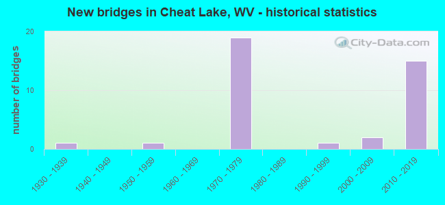
- New bridges - historical statistics
- 11930-1939
- 11950-1959
- 191970-1979
- 11990-1999
- 22000-2009
- 152010-2019


- Bridge Condition - Deck
- 4.8%Very good
- 47.6%Good
- 38.1%Satisfactory
- 4.8%Fair
- 4.8%Poor

- Bridge Condition - Superstructure
- 8.7%Very good
- 73.9%Good
- 8.7%Satisfactory
- 4.3%Fair
- 4.3%Poor

- Bridge Condition - Substructure
- 69.6%Good
- 13.0%Satisfactory
- 8.7%Fair
- 8.7%Poor

- Bridge Condition - Channel
- 77.8%Very good
- 22.2%Good
Find on map >> Show street view
Structure Number: 31A124, Location: 0.01 MI SOUTH MGL CO 857 (Lat: 39.670969, Lng: -79.859061), Route carried "on" structure: County highway 85717, Year Built: 1973, Status: Open, Structure Length: 4.80m (15.75ft), Average Daily Traffic: 2,000 (year 2019), Truck Traffic: 6%, Average Future Daily Traffic: 3,100 (year 2041), Design Load: HS 20, Features Intersected: MGL CO RT 857/17, Facility Carried by Structure: MGL CO RT 857/17
Minimum Vertical Clearance: 30+ m (98+ ft), Kilometerpoint: 0.016, Lanes on structure: 2, Lanes under structure: 4, Owner: State Highway Agency, Approaching Roadway Width: 9.8m (32.2ft), Skew: 2 degrees, Material/Design: Concrete, Design/Construction: Box Beam or Girders - Single/Spread, Number Of Spans In Main Unit: 1, Length of Maximum Span: 45.8m (150.3ft), Curb-To-Curb Width: 9.9m (32.5ft), Out-to-Out Width: 11.2m (36.7ft)
Condition: Superstructure: Good, Substructure: Good, Operating Rating: 85.3 metric tons, Method Used To Determine Operating Rating: Field evaluation and documented engineering judgment, Inventory Rating: 32.7 metric tons, Method Used To Determine Inventory Rating: Field evaluation and documented engineering judgment, Structural Evaluation: Better than present minimum criteria, Deck Geometry: Somewhat better than minimum adequacy, Underclear: Somewhat better than minimum adequacy, Approach Roadway Alignment: Better than present minimum criteria, Designated Inspection Frequency: Every 24 months, Inspection Date: May 2021, Deck Structure Type: Concrete Cast-file-Place, Wearing Surface/Protective System: Wearing Surface: Bituminous, Membrane: Preformed Fabric
Find on map >> Show street view
Structure Number: 31A126, Location: 3.08 MI EAST CO RT 857 (Lat: 39.671500, Lng: -79.851000), Route carried "on" structure: Interstate 6800, Year Built: 1973, Status: Open, Structure Length: 5.49m (18.01ft), Average Daily Traffic: 9,000 (year 2019), Truck Traffic: 16%, Average Future Daily Traffic: 12,870 (year 2041), Design Load: HS 20, Features Intersected: Mon Co 69/6, Facility Carried by Structure: INTERSTATE 68 EB
Minimum Vertical Clearance: 30+ m (98+ ft), Kilometerpoint: 16.544, Lanes on structure: 3, Lanes under structure: 3, Base Highway Network: Yes, Owner: State Highway Agency, Approaching Roadway Width: 13.4m (44.0ft), Material/Design: Steel continuous, Design/Construction: Stringer/Multi-beam, Number Of Spans In Main Unit: 1, Number Of Approach Spans: 2, Length of Maximum Span: 23.2m (76.1ft), Curb-To-Curb Width: 14.2m (46.6ft), Out-to-Out Width: 15.4m (50.5ft)
Condition: Deck: Satisfactory, Superstructure: Good, Substructure: Fair, Operating Rating: 63.5 metric tons, Method Used To Determine Operating Rating: Load Factor (LF), Inventory Rating: 38.1 metric tons, Method Used To Determine Inventory Rating: Load Factor (LF), Structural Evaluation: Somewhat better than minimum adequacy, Deck Geometry: Meets minimum limits, Underclear: Meets minimum limits, Approach Roadway Alignment: Better than present minimum criteria, Length Of Structure Improvement: 5.49m (18.01ft), Designated Inspection Frequency: Every 24 months, Inspection Date: December 2021, Bridge Improvement Cost: $431,000, Roadway Improvement Cost: $183,000, Total Project Cost: $953,000 ( Estimate for 2022), Deck Structure Type: Concrete Cast-file-Place, Wearing Surface/Protective System: Wearing Surface: Monolithic Concrete
Find on map >> Show street view
Structure Number: 31A127, Location: 3.08 MI EAST CO RT 857 (Lat: 39.671600, Lng: -79.850900), Route carried "on" structure: Interstate 6800, Year Built: 1973, Status: Open, Structure Length: 5.49m (18.01ft), Average Daily Traffic: 9,000 (year 2019), Truck Traffic: 16%, Average Future Daily Traffic: 12,870 (year 2041), Design Load: HS 20, Features Intersected: Mon. Co. 69/6, Facility Carried by Structure: INTERSTATE 68 WB
Minimum Vertical Clearance: 30+ m (98+ ft), Kilometerpoint: 16.544, Lanes on structure: 2, Lanes under structure: 3, Base Highway Network: Yes, Owner: State Highway Agency, Approaching Roadway Width: 11.6m (38.1ft), Material/Design: Steel continuous, Design/Construction: Stringer/Multi-beam, Number Of Spans In Main Unit: 1, Number Of Approach Spans: 2, Length of Maximum Span: 23.2m (76.1ft), Curb-To-Curb Width: 12.3m (40.4ft), Out-to-Out Width: 13.6m (44.6ft)
Condition: Deck: Satisfactory, Superstructure: Good, Substructure: Fair, Operating Rating: 63.5 metric tons, Method Used To Determine Operating Rating: Load Factor (LF), Inventory Rating: 38.1 metric tons, Method Used To Determine Inventory Rating: Load Factor (LF), Structural Evaluation: Somewhat better than minimum adequacy, Deck Geometry: Better than present minimum criteria, Underclear: Somewhat better than minimum adequacy, Approach Roadway Alignment: Better than present minimum criteria, Length Of Structure Improvement: 5.49m (18.01ft), Designated Inspection Frequency: Every 24 months, Inspection Date: December 2021, Bridge Improvement Cost: $431,000, Roadway Improvement Cost: $183,000, Total Project Cost: $953,000 ( Estimate for 2022), Deck Structure Type: Concrete Cast-file-Place, Wearing Surface/Protective System: Wearing Surface: Monolithic Concrete
Find on map >> Show street view
Structure Number: 31A142, Location: 1.44 MI WEST MON CO 857 (Lat: 39.627239, Lng: -79.903461), Route carried "on" structure: Interstate 6800, Year Built: 1975, Status: Open, Structure Length: 4.43m (14.53ft), Average Daily Traffic: 19,350 (year 2018), Truck Traffic: 18%, Average Future Daily Traffic: 26,325 (year 2038), Design Load: HS 20, Features Intersected: Mgl Co Rt 68/7, Facility Carried by Structure: INTERSTATE 68 EB
Minimum Vertical Clearance: 30+ m (98+ ft), Kilometerpoint: 9.270, Lanes on structure: 2, Lanes under structure: 2, Base Highway Network: Yes, Owner: State Highway Agency, Approaching Roadway Width: 11.6m (38.1ft), Skew: 3 degrees, Material/Design: Steel continuous, Design/Construction: Stringer/Multi-beam, Number Of Spans In Main Unit: 1, Number Of Approach Spans: 2, Length of Maximum Span: 16.5m (54.1ft), Curb-To-Curb Width: 12.3m (40.4ft), Out-to-Out Width: 13.6m (44.6ft)
Condition: Deck: Fair, Superstructure: Good, Substructure: Satisfactory, Operating Rating: 62.6 metric tons, Method Used To Determine Operating Rating: Load Factor (LF), Inventory Rating: 37.2 metric tons, Method Used To Determine Inventory Rating: Load Factor (LF), Structural Evaluation: Equal to present minimum criteria, Deck Geometry: Better than present minimum criteria, Underclear: Somewhat better than minimum adequacy, Approach Roadway Alignment: Equal to present desirable criteria, Length Of Structure Improvement: 4.39m (14.40ft), Designated Inspection Frequency: Every 24 months, Inspection Date: January 2020, Bridge Improvement Cost: $281,000, Roadway Improvement Cost: $92,000, Total Project Cost: $428,000 ( Estimate for 2020), Deck Structure Type: Concrete Cast-file-Place, Wearing Surface/Protective System: Wearing Surface: Monolithic Concrete
Find on map >> Show street view
Structure Number: 31A143, Location: 0.02 MI NORTH CO RT 857 (Lat: 39.653681, Lng: -79.889281), Route carried "on" structure: County highway 6700, Year Built: 1976, Status: Open, Structure Length: 6.90m (22.64ft), Average Daily Traffic: 4,400 (year 2018), Truck Traffic: 6%, Average Future Daily Traffic: 5,975 (year 2038), Design Load: HS 20, Features Intersected: I-68 (X), Facility Carried by Structure: MON CO Rt. 67
Minimum Vertical Clearance: 30+ m (98+ ft), Kilometerpoint: 4.152, Lanes on structure: 2, Lanes under structure: 4, Owner: State Highway Agency, Approaching Roadway Width: 8.5m (27.9ft), Material/Design: Steel continuous, Design/Construction: Stringer/Multi-beam, Number Of Spans In Main Unit: 2, Length of Maximum Span: 33.7m (110.6ft), Curb-To-Curb Width: 9.9m (32.5ft), Out-to-Out Width: 11.2m (36.7ft)
Condition: Deck: Satisfactory, Superstructure: Good, Substructure: Good, Operating Rating: 67.1 metric tons, Method Used To Determine Operating Rating: Load Factor (LF), Inventory Rating: 39.9 metric tons, Method Used To Determine Inventory Rating: Load Factor (LF), Structural Evaluation: Better than present minimum criteria, Deck Geometry: Meets minimum limits, Underclear: Somewhat better than minimum adequacy, Approach Roadway Alignment: Equal to present desirable criteria, Designated Inspection Frequency: Every 24 months, Inspection Date: March 2020, Deck Structure Type: Concrete Cast-file-Place, Wearing Surface/Protective System: Wearing Surface: Monolithic Concrete
Find on map >> Show street view
Structure Number: 31A147, Location: 0.05 MI SOUTH CO RT 71/1 (Lat: 39.705069, Lng: -79.830831), Route carried "on" structure: County highway 7100, Year Built: 1950, Status: Posted for load, Structure Length: 0.75m (2.46ft), Average Daily Traffic: 250 (year 2018), Truck Traffic: 6%, Average Future Daily Traffic: 350 (year 2038), Features Intersected: MORGAN RUN, Facility Carried by Structure: MONONGALIA CR 71
Minimum Vertical Clearance: 30+ m (98+ ft), Kilometerpoint: 1.465, Lanes on structure: 1, Owner: State Highway Agency, Approaching Roadway Width: 3.7m (12.1ft), Skew: 1 degrees, Material/Design: Steel continuous, Design/Construction: Stringer/Multi-beam, Number Of Spans In Main Unit: 1, Number Of Approach Spans: 1, Length of Maximum Span: 3.5m (11.5ft), Curb-To-Curb Width: 3.6m (11.8ft), Out-to-Out Width: 3.6m (11.8ft)
Condition: Deck: Good, Superstructure: Poor, Substructure: Poor, Channel: Good, Operating Rating: 31.7 metric tons, Method Used To Determine Operating Rating: Load Factor (LF), Inventory Rating: 19.0 metric tons, Method Used To Determine Inventory Rating: Load Factor (LF), Structural Evaluation: Meets minimum limits, Deck Geometry: High priority of replacement, Waterway Adequacy: Better than present minimum criteria, Approach Roadway Alignment: Meets minimum limits, Length Of Structure Improvement: 1.34m (4.40ft), Designated Inspection Frequency: Every 24 months, Inspection Date: May 2020, Bridge Improvement Cost: $171,000, Roadway Improvement Cost: $132,000, Total Project Cost: $364,000 ( Estimate for 2020), Deck Structure Type: Wood or Timber, Wearing Surface/Protective System: Wearing Surface: Bituminous
Find on map >> Show street view
Structure Number: 31A148, Location: 0.88 MI WEST CO RT 69/6 (Lat: 39.669311, Lng: -79.863700), Route carried "on" structure: Interstate 6800, Year Built: 1976, Status: Open, Structure Length: 59.92m (196.59ft), Average Daily Traffic: 33,946 (year 2020), Truck Traffic: 18%, Average Future Daily Traffic: 45,500 (year 2040), Design Load: HS 20, Features Intersected: Cheat Lake & Mon Co 857, Facility Carried by Structure: INTERSTATE 68
Minimum Vertical Clearance: 30+ m (98+ ft), Kilometerpoint: 15.128, Lanes on structure: 4, Lanes under structure: 1, Base Highway Network: Yes, Owner: State Highway Agency, Approaching Roadway Width: 25.9m (85.0ft), Skew: 30 degrees, Material/Design: Steel continuous, Design/Construction: Truss - Deck, Number Of Spans In Main Unit: 5, Number Of Approach Spans: 2, Length of Maximum Span: 110.9m (363.8ft), Curb-To-Curb Width: 24.8m (81.4ft), Out-to-Out Width: 26.6m (87.3ft)
Condition: Deck: Satisfactory, Superstructure: Fair, Substructure: Satisfactory, Channel: Very good, Operating Rating: 43.5 metric tons, Method Used To Determine Operating Rating: Load Factor (LF), Inventory Rating: 25.4 metric tons, Method Used To Determine Inventory Rating: Load Factor (LF), Structural Evaluation: Somewhat better than minimum adequacy, Deck Geometry: Superior to present desirable criteria, Underclear: Better than present minimum criteria, Waterway Adequacy: Superior to present desirable criteria, Approach Roadway Alignment: Better than present minimum criteria, Length Of Structure Improvement: 59.92m (196.59ft), Designated Inspection Frequency: Every 24 months, Critical Feature Inspection Frequency: Every 24 months, Underwater Inspection Frequency: Every 60 months, Other Special Inspection Frequency: Every 12 months, Inspection Date: September 2021, Critical Feature Inspection Date: September 2021, Underwater Inspection Date: September 2019, Other Special Inspection Date: September 2021, Bridge Improvement Cost: $1,664,000, Roadway Improvement Cost: $117,000, Total Project Cost: $2,148,000 ( Estimate for 2018), Deck Structure Type: Concrete Cast-file-Place, Wearing Surface/Protective System: Wearing Surface: Monolithic Concrete
Find on map >> Show street view
Structure Number: 31A206, Location: 0.36 MI SOUTH CO RT 67 (Lat: 39.646600, Lng: -79.894600), Route carried "on" structure: County highway 85700, Year Built: 1973, Status: Open, Structure Length: 6.43m (21.10ft), Average Daily Traffic: 27,300 (year 2019), Truck Traffic: 6%, Average Future Daily Traffic: 42,320 (year 2041), Design Load: HL 93, Features Intersected: I-68 (X), Facility Carried by Structure: MONONGALIA CR 857
Minimum Vertical Clearance: 30+ m (98+ ft), Kilometerpoint: 11.684, Lanes on structure: 6, Lanes under structure: 4, Base Highway Network: Yes, Owner: State Highway Agency, Approaching Roadway Width: 24.4m (80.1ft), Skew: 1 degrees, Material/Design: Steel continuous, Design/Construction: Stringer/Multi-beam, Number Of Spans In Main Unit: 2, Length of Maximum Span: 31.6m (103.7ft), Curb-To-Curb Width: 27.4m (89.9ft), Out-to-Out Width: 28.2m (92.5ft)
Condition: Deck: Very good, Superstructure: Satisfactory, Substructure: Good, Operating Rating: 68.0 metric tons, Method Used To Determine Operating Rating: Load Factor (LF), Inventory Rating: 40.8 metric tons, Method Used To Determine Inventory Rating: Load Factor (LF), Structural Evaluation: Equal to present minimum criteria, Deck Geometry: Better than present minimum criteria, Underclear: Somewhat better than minimum adequacy, Approach Roadway Alignment: Equal to present desirable criteria, Length Of Structure Improvement: 6.71m (22.01ft), Designated Inspection Frequency: Every 24 months, Inspection Date: November 2021, Deck Structure Type: Concrete Cast-file-Place, Wearing Surface/Protective System: Wearing Surface: Integral Concrete
Find on map >> Show street view
Structure Number: 31A208, Location: 0.02 MI SOUTH CO RT 69/2 (Lat: 39.697081, Lng: -79.816719), Route carried "on" structure: County highway 85700, Year Built: 1936, Status: Open, Structure Length: 0.82m (2.69ft), Average Daily Traffic: 2,000 (year 2019), Truck Traffic: 6%, Average Future Daily Traffic: 3,100 (year 2041), Features Intersected: DARNELL RUN, Facility Carried by Structure: MON CO RT 857
Minimum Vertical Clearance: 30+ m (98+ ft), Kilometerpoint: 22.000, Lanes on structure: 2, Owner: State Highway Agency, Approaching Roadway Width: 7.9m (25.9ft), Material/Design: Masonry, Design/Construction: Arch - Deck, Number Of Spans In Main Unit: 1, Length of Maximum Span: 7.3m (24.0ft), Curb-To-Curb Width: 10.3m (33.8ft), Out-to-Out Width: 11.1m (36.4ft)
Condition: Superstructure: Satisfactory, Substructure: Good, Channel: Very good, Operating Rating: 63.5 metric tons, Method Used To Determine Operating Rating: Field evaluation and documented engineering judgment, Inventory Rating: 29.0 metric tons, Method Used To Determine Inventory Rating: Field evaluation and documented engineering judgment, Structural Evaluation: Equal to present minimum criteria, Deck Geometry: Somewhat better than minimum adequacy, Waterway Adequacy: Equal to present desirable criteria, Approach Roadway Alignment: High priority of replacement, Length Of Structure Improvement: 1.37m (4.49ft), Designated Inspection Frequency: Every 24 months, Inspection Date: April 2021, Bridge Improvement Cost: $324,000, Roadway Improvement Cost: $163,000, Total Project Cost: $522,000 ( Estimate for 2021)
Find on map >> Show street view
Structure Number: 31A27, Location: 0.02 MI NORTH CO RT 75/1 (Lat: 39.658681, Lng: -79.863981), Route carried "on" structure: County highway 7500, Year Built: 1996, Status: Open, Structure Length: 0.94m (3.08ft), Average Daily Traffic: 3,300 (year 2019), Truck Traffic: 6%, Average Future Daily Traffic: 5,100 (year 2041), Design Load: HS 25 or greater, Features Intersected: WHITES RUN, Facility Carried by Structure: MON. CO. Rt. 75
Minimum Vertical Clearance: 30+ m (98+ ft), Kilometerpoint: 6.840, Lanes on structure: 2, Owner: State Highway Agency, Approaching Roadway Width: 7.9m (25.9ft), Skew: 2 degrees, Material/Design: Prestressed concrete, Design/Construction: Box Beam or Girders - Multiple, Number Of Spans In Main Unit: 1, Length of Maximum Span: 7.9m (25.9ft), Curb-To-Curb Width: 8.0m (26.2ft), Out-to-Out Width: 8.5m (27.9ft)
Condition: Deck: Satisfactory, Superstructure: Good, Substructure: Good, Channel: Good, Operating Rating: 88.9 metric tons, Method Used To Determine Operating Rating: Load Factor (LF), Inventory Rating: 88.9 metric tons, Method Used To Determine Inventory Rating: Load Factor (LF), Structural Evaluation: Better than present minimum criteria, Deck Geometry: High priority of corrective action, Waterway Adequacy: Equal to present desirable criteria, Approach Roadway Alignment: Equal to present desirable criteria, Length Of Structure Improvement: 1.07m (3.51ft), Designated Inspection Frequency: Every 24 months, Inspection Date: April 2021, Bridge Improvement Cost: $211,000, Roadway Improvement Cost: $89,000, Total Project Cost: $348,000 ( Estimate for 2021), Deck Structure Type: Other, Wearing Surface/Protective System: Deck Protection: Epoxy Coated Reinforcing
Find on map >> Show street view
Structure Number: 31A312, Location: 0.21 mi. N. of I 68 (Lat: 39.675800, Lng: -79.848581), Route carried "on" structure: State highway 43, Year Built: 2010, Status: Open, Structure Length: 8.96m (29.40ft), Average Daily Traffic: 900 (year 2019), Truck Traffic: 6%, Average Future Daily Traffic: 1,160 (year 2041), Design Load: HS 25 or greater, Features Intersected: Mon. Co. Rt. 857
Minimum Vertical Clearance: 30+ m (98+ ft), Kilometerpoint: 0.338, Lanes on structure: 3, Lanes under structure: 3, Owner: State Highway Agency, Approaching Roadway Width: 14.0m (45.9ft), Skew: 3 degrees, Material/Design: Prestressed concrete continuous, Design/Construction: Stringer/Multi-beam, Number Of Spans In Main Unit: 1, Number Of Approach Spans: 2, Length of Maximum Span: 37.5m (123.0ft), Curb-To-Curb Width: 14.7m (48.2ft), Out-to-Out Width: 15.5m (50.9ft)
Condition: Deck: Good, Superstructure: Good, Substructure: Good, Operating Rating: 77.1 metric tons, Method Used To Determine Operating Rating: Load Factor (LF), Inventory Rating: 46.3 metric tons, Method Used To Determine Inventory Rating: Load Factor (LF), Structural Evaluation: Better than present minimum criteria, Deck Geometry: Meets minimum limits, Underclear: Meets minimum limits, Approach Roadway Alignment: Equal to present desirable criteria, Designated Inspection Frequency: Every 24 months, Inspection Date: December 2021, Deck Structure Type: Concrete Cast-file-Place, Wearing Surface/Protective System: Deck Protection: Epoxy Coated Reinforcing
Find on map >> Show street view
Structure Number: 31A313, Location: 0.21 mi. N. I 68 (Lat: 39.675739, Lng: -79.848939), Route carried "on" structure: State highway 43, Year Built: 2010, Status: Open, Structure Length: 8.96m (29.40ft), Average Daily Traffic: 900 (year 2019), Truck Traffic: 6%, Average Future Daily Traffic: 1,160 (year 2041), Design Load: HS 25 or greater, Features Intersected: Mon. Co. Rt. 857
Minimum Vertical Clearance: 7.67m (25.16ft), Kilometerpoint: 0.338, Lanes on structure: 2, Lanes under structure: 3, Owner: State Highway Agency, Approaching Roadway Width: 13.4m (44.0ft), Skew: 3 degrees, Material/Design: Prestressed concrete continuous, Design/Construction: Stringer/Multi-beam, Number Of Spans In Main Unit: 1, Number Of Approach Spans: 2, Length of Maximum Span: 37.5m (123.0ft), Curb-To-Curb Width: 13.5m (44.3ft), Out-to-Out Width: 14.3m (46.9ft)
Condition: Deck: Good, Superstructure: Good, Substructure: Good, Operating Rating: 77.1 metric tons, Method Used To Determine Operating Rating: Load Factor (LF), Inventory Rating: 46.3 metric tons, Method Used To Determine Inventory Rating: Load Factor (LF), Structural Evaluation: Better than present minimum criteria, Deck Geometry: Superior to present desirable criteria, Underclear: Meets minimum limits, Approach Roadway Alignment: Equal to present desirable criteria, Designated Inspection Frequency: Every 24 months, Inspection Date: December 2021, Deck Structure Type: Concrete Cast-file-Place, Wearing Surface/Protective System: Deck Protection: Epoxy Coated Reinforcing
Find on map >> Show street view
Structure Number: 31A314, Location: 0.4 mi. N of MON CO 857 (Lat: 39.680500, Lng: -79.847600), Route carried "on" structure: State highway 43, Year Built: 2010, Status: Open, Structure Length: 9.60m (31.50ft), Average Daily Traffic: 900 (year 2019), Truck Traffic: 6%, Average Future Daily Traffic: 1,160 (year 2041), Design Load: HS 25 or greater, Features Intersected: Mon Co Rt 88/1 (SLS)
Minimum Vertical Clearance: 30+ m (98+ ft), Kilometerpoint: 0.901, Lanes on structure: 4, Lanes under structure: 2, Owner: State Highway Agency, Approaching Roadway Width: 15.5m (50.9ft), Skew: 13 degrees, Material/Design: Prestressed concrete continuous, Design/Construction: Stringer/Multi-beam, Number Of Spans In Main Unit: 1, Number Of Approach Spans: 2, Length of Maximum Span: 42.8m (140.4ft), Curb-To-Curb Width: 20.6m (67.6ft), Out-to-Out Width: 21.3m (69.9ft)
Condition: Deck: Good, Superstructure: Good, Substructure: Good, Operating Rating: 88.9 metric tons, Method Used To Determine Operating Rating: Load Factor (LF), Inventory Rating: 54.4 metric tons, Method Used To Determine Inventory Rating: Load Factor (LF), Structural Evaluation: Better than present minimum criteria, Deck Geometry: Equal to present minimum criteria, Underclear: Somewhat better than minimum adequacy, Approach Roadway Alignment: Equal to present desirable criteria, Designated Inspection Frequency: Every 24 months, Inspection Date: December 2021, Deck Structure Type: Concrete Cast-file-Place, Wearing Surface/Protective System: Deck Protection: Epoxy Coated Reinforcing
Find on map >> Show street view
Structure Number: 31A315, Location: 0.6 mi. N of MON CO 857 (Lat: 39.680900, Lng: -79.848000), Route carried "on" structure: State highway 43, Year Built: 2011, Status: Open, Structure Length: 9.60m (31.50ft), Average Daily Traffic: 900 (year 2019), Truck Traffic: 6%, Average Future Daily Traffic: 1,160 (year 2041), Design Load: HS 25 or greater, Features Intersected: MON CO RT 88/1 (SLS)
Minimum Vertical Clearance: 30+ m (98+ ft), Kilometerpoint: 0.901, Lanes on structure: 3, Lanes under structure: 2, Owner: State Highway Agency, Approaching Roadway Width: 15.5m (50.9ft), Skew: 3 degrees, Material/Design: Prestressed concrete continuous, Design/Construction: Stringer/Multi-beam, Number Of Spans In Main Unit: 1, Number Of Approach Spans: 2, Length of Maximum Span: 42.8m (140.4ft), Curb-To-Curb Width: 18.2m (59.7ft), Out-to-Out Width: 19.0m (62.3ft)
Condition: Deck: Good, Superstructure: Good, Substructure: Good, Operating Rating: 88.9 metric tons, Method Used To Determine Operating Rating: Load Factor (LF), Inventory Rating: 54.4 metric tons, Method Used To Determine Inventory Rating: Load Factor (LF), Structural Evaluation: Better than present minimum criteria, Deck Geometry: Better than present minimum criteria, Underclear: Somewhat better than minimum adequacy, Approach Roadway Alignment: Equal to present desirable criteria, Designated Inspection Frequency: Every 24 months, Inspection Date: December 2021, Deck Structure Type: Concrete Cast-file-Place, Wearing Surface/Protective System: Deck Protection: Epoxy Coated Reinforcing
Find on map >> Show street view
Structure Number: 31A316, Location: 1.0 MILES N OF MON CO 857 (Lat: 39.687489, Lng: -79.845381), Route carried "on" structure: State highway 4300, Year Built: 2010, Status: Open, Structure Length: 44.01m (144.39ft), Average Daily Traffic: 900 (year 2019), Truck Traffic: 6%, Average Future Daily Traffic: 1,160 (year 2041), Design Load: HS 25 or greater, Features Intersected: Mon. Co. 69/17, Facility Carried by Structure: WV Rt. 43
Minimum Vertical Clearance: 30+ m (98+ ft), Kilometerpoint: 1.754, Lanes on structure: 3, Lanes under structure: 2, Owner: State Highway Agency, Approaching Roadway Width: 14.0m (45.9ft), Skew: 10 degrees, Material/Design: Prestressed concrete continuous, Design/Construction: Stringer/Multi-beam, Number Of Spans In Main Unit: 1, Number Of Approach Spans: 2, Length of Maximum Span: 16.5m (54.1ft), Curb-To-Curb Width: 14.6m (47.9ft), Out-to-Out Width: 15.4m (50.5ft)
Condition: Deck: Good, Superstructure: Good, Substructure: Good, Operating Rating: 78.9 metric tons, Method Used To Determine Operating Rating: Load Factor (LF), Inventory Rating: 47.2 metric tons, Method Used To Determine Inventory Rating: Load Factor (LF), Structural Evaluation: Better than present minimum criteria, Deck Geometry: Meets minimum limits, Underclear: High priority of corrective action, Approach Roadway Alignment: Equal to present desirable criteria, Designated Inspection Frequency: Every 24 months, Inspection Date: September 2021, Deck Structure Type: Concrete Cast-file-Place, Wearing Surface/Protective System: Deck Protection: Epoxy Coated Reinforcing
Find on map >> Show street view
Structure Number: 31A317, Location: 1.0 MILES N OF MON CO 857 (Lat: 39.687669, Lng: -79.845600), Route carried "on" structure: State highway 4300, Year Built: 2010, Status: Open, Structure Length: 4.40m (14.44ft), Average Daily Traffic: 900 (year 2019), Truck Traffic: 6%, Average Future Daily Traffic: 1,160 (year 2041), Design Load: HS 25 or greater, Features Intersected: MON. CO. 69/17, Facility Carried by Structure: WV Rt. 43
Minimum Vertical Clearance: 30+ m (98+ ft), Kilometerpoint: 1.754, Lanes on structure: 3, Lanes under structure: 2, Owner: State Highway Agency, Approaching Roadway Width: 14.9m (48.9ft), Skew: 10 degrees, Material/Design: Prestressed concrete continuous, Design/Construction: Stringer/Multi-beam, Number Of Spans In Main Unit: 1, Number Of Approach Spans: 2, Length of Maximum Span: 16.5m (54.1ft), Curb-To-Curb Width: 19.4m (63.6ft), Out-to-Out Width: 20.2m (66.3ft)
Condition: Deck: Good, Superstructure: Good, Substructure: Good, Operating Rating: 71.7 metric tons, Method Used To Determine Operating Rating: Load Factor (LF), Inventory Rating: 43.5 metric tons, Method Used To Determine Inventory Rating: Load Factor (LF), Structural Evaluation: Better than present minimum criteria, Deck Geometry: Superior to present desirable criteria, Underclear: High priority of corrective action, Approach Roadway Alignment: Equal to present desirable criteria, Designated Inspection Frequency: Every 24 months, Inspection Date: September 2021, Deck Structure Type: Concrete Cast-file-Place, Wearing Surface/Protective System: Deck Protection: Epoxy Coated Reinforcing
Find on map >> Show street view
Structure Number: 31A318, Location: 2.48 mi. N. of I68 (Lat: 39.701919, Lng: -79.829050), Route carried "on" structure: State highway 43, Year Built: 2008, Status: Open, Structure Length: 42.20m (138.45ft), Average Daily Traffic: 900 (year 2019), Truck Traffic: 6%, Average Future Daily Traffic: 900 (year 2038), Design Load: HS 25 or greater, Features Intersected: Mon Co 71, Morgan Run
Minimum Vertical Clearance: 30+ m (98+ ft), Kilometerpoint: 3.991, Lanes on structure: 2, Lanes under structure: 2, Base Highway Network: Yes, Owner: State Highway Agency, Approaching Roadway Width: 11.3m (37.1ft), Material/Design: Steel continuous, Design/Construction: Stringer/Multi-beam, Number Of Spans In Main Unit: 2, Number Of Approach Spans: 4, Length of Maximum Span: 76.0m (249.3ft), Curb-To-Curb Width: 9.6m (31.5ft), Out-to-Out Width: 10.4m (34.1ft)
Condition: Deck: Good, Superstructure: Very good, Substructure: Good, Channel: Very good, Operating Rating: 63.5 metric tons, Method Used To Determine Operating Rating: Assigned rating based on Load Factor Design (LFD) reported in metric tons, Inventory Rating: 40.8 metric tons, Method Used To Determine Inventory Rating: Assigned rating based on Load Factor Design (LFD) reported in metric tons, Structural Evaluation: Better than present minimum criteria, Deck Geometry: Meets minimum limits, Underclear: Superior to present desirable criteria, Waterway Adequacy: Better than present minimum criteria, Approach Roadway Alignment: Equal to present desirable criteria, Designated Inspection Frequency: Every 24 months, Inspection Date: July 2021, Deck Structure Type: Concrete Cast-file-Place, Wearing Surface/Protective System: Wearing Surface: Monolithic Concrete, Deck Protection: Epoxy Coated Reinforcing
Find on map >> Show street view
Structure Number: 31A319, Location: 2.48 mi. N. of I68 (Lat: 39.702200, Lng: -79.829100), Route carried "on" structure: State highway 43, Year Built: 2008, Status: Open, Structure Length: 42.20m (138.45ft), Average Daily Traffic: 900 (year 2019), Truck Traffic: 6%, Average Future Daily Traffic: 900 (year 2038), Design Load: HS 25 or greater, Features Intersected: Mon Co 71 & Morgan Run
Minimum Vertical Clearance: 30+ m (98+ ft), Kilometerpoint: 3.991, Lanes on structure: 2, Lanes under structure: 2, Base Highway Network: Yes, Owner: State Highway Agency, Approaching Roadway Width: 11.3m (37.1ft), Material/Design: Steel continuous, Design/Construction: Stringer/Multi-beam, Number Of Spans In Main Unit: 1, Number Of Approach Spans: 5, Length of Maximum Span: 80.0m (262.5ft), Curb-To-Curb Width: 9.6m (31.5ft), Out-to-Out Width: 10.4m (34.1ft)
Condition: Deck: Good, Superstructure: Very good, Substructure: Good, Channel: Very good, Operating Rating: 63.5 metric tons, Method Used To Determine Operating Rating: Assigned rating based on Load Factor Design (LFD) reported in metric tons, Inventory Rating: 40.8 metric tons, Method Used To Determine Inventory Rating: Assigned rating based on Load Factor Design (LFD) reported in metric tons, Structural Evaluation: Better than present minimum criteria, Deck Geometry: Meets minimum limits, Underclear: Superior to present desirable criteria, Waterway Adequacy: Superior to present desirable criteria, Approach Roadway Alignment: Equal to present desirable criteria, Designated Inspection Frequency: Every 24 months, Inspection Date: July 2021, Deck Structure Type: Concrete Cast-file-Place, Wearing Surface/Protective System: Wearing Surface: Monolithic Concrete, Deck Protection: Epoxy Coated Reinforcing
Find on map >> Show street view
Structure Number: 31A32, Location: 0.2 miles S of PA line (Lat: 39.718831, Lng: -79.822419), Route carried "on" structure: State highway 43, Year Built: 2011, Status: Open, Structure Length: 44.00m (144.36ft), Average Daily Traffic: 900 (year 2019), Truck Traffic: 6%, Average Future Daily Traffic: 900 (year 2038), Design Load: HS 25 or greater, Features Intersected: Rubles Run
Minimum Vertical Clearance: 30+ m (98+ ft), Kilometerpoint: 5.697, Lanes on structure: 2, Base Highway Network: Yes, Owner: State Highway Agency, Approaching Roadway Width: 11.3m (37.1ft), Material/Design: Steel continuous, Design/Construction: Stringer/Multi-beam, Number Of Spans In Main Unit: 2, Number Of Approach Spans: 4, Length of Maximum Span: 84.0m (275.6ft), Curb-To-Curb Width: 9.6m (31.5ft), Out-to-Out Width: 10.6m (34.8ft)
Condition: Deck: Satisfactory, Superstructure: Good, Substructure: Good, Channel: Very good, Operating Rating: 63.5 metric tons, Method Used To Determine Operating Rating: Assigned rating based on Load Factor Design (LFD) reported in metric tons, Inventory Rating: 40.8 metric tons, Method Used To Determine Inventory Rating: Assigned rating based on Load Factor Design (LFD) reported in metric tons, Structural Evaluation: Better than present minimum criteria, Deck Geometry: Meets minimum limits, Waterway Adequacy: Superior to present desirable criteria, Approach Roadway Alignment: Equal to present desirable criteria, Designated Inspection Frequency: Every 24 months, Inspection Date: July 2021, Deck Structure Type: Concrete Cast-file-Place, Wearing Surface/Protective System: Wearing Surface: Latex Concrete, Deck Protection: Epoxy Coated Reinforcing
Find on map >> Show street view
Structure Number: 31A321, Location: 1.7mi s of penn.st. 3002 (Lat: 39.719011, Lng: -79.822669), Route carried "on" structure: State highway 43, Year Built: 2011, Status: Open, Structure Length: 41.85m (137.30ft), Average Daily Traffic: 900 (year 2019), Truck Traffic: 6%, Average Future Daily Traffic: 900 (year 2038), Design Load: HS 25 or greater, Features Intersected: Rubles Run
Minimum Vertical Clearance: 30+ m (98+ ft), Kilometerpoint: 5.697, Lanes on structure: 2, Base Highway Network: Yes, Owner: State Highway Agency, Approaching Roadway Width: 11.3m (37.1ft), Material/Design: Steel continuous, Design/Construction: Stringer/Multi-beam, Number Of Spans In Main Unit: 2, Number Of Approach Spans: 4, Length of Maximum Span: 77.5m (254.3ft), Curb-To-Curb Width: 9.6m (31.5ft), Out-to-Out Width: 10.6m (34.8ft)
Condition: Deck: Satisfactory, Superstructure: Good, Substructure: Good, Channel: Very good, Operating Rating: 63.5 metric tons, Method Used To Determine Operating Rating: Assigned rating based on Load Factor Design (LFD) reported in metric tons, Inventory Rating: 40.8 metric tons, Method Used To Determine Inventory Rating: Assigned rating based on Load Factor Design (LFD) reported in metric tons, Structural Evaluation: Better than present minimum criteria, Deck Geometry: Meets minimum limits, Waterway Adequacy: Superior to present desirable criteria, Approach Roadway Alignment: Equal to present desirable criteria, Designated Inspection Frequency: Every 24 months, Inspection Date: July 2021, Deck Structure Type: Concrete Cast-file-Place, Wearing Surface/Protective System: Wearing Surface: Latex Concrete, Deck Protection: Epoxy Coated Reinforcing
Find on map >> Show street view
Structure Number: 31A324, Location: 0.20 mi. S. of Co. 69/8 (Lat: 39.667300, Lng: -79.860600), Route carried "on" structure: County highway 857, Year Built: 2012, Status: Open, Structure Length: 29.50m (96.78ft), Average Daily Traffic: 5,300 (year 2018), Truck Traffic: 6%, Average Future Daily Traffic: 7,200 (year 2038), Design Load: HL 93, Features Intersected: CHEAT LAKE
Minimum Vertical Clearance: 30+ m (98+ ft), Kilometerpoint: 16.415, Lanes on structure: 2, Owner: State Highway Agency, Approaching Roadway Width: 11.0m (36.1ft), Skew: 9 degrees, Material/Design: Steel continuous, Design/Construction: Stringer/Multi-beam, Number Of Spans In Main Unit: 2, Number Of Approach Spans: 2, Length of Maximum Span: 79.2m (259.8ft), Curb or Sidewalk Widths: Left: 1.6m (5.2ft), Right: 0.0m, Curb-To-Curb Width: 9.1m (29.9ft), Out-to-Out Width: 11.4m (37.4ft)
Condition: Deck: Good, Superstructure: Good, Substructure: Good, Channel: Very good, Operating Rating: 57.1 metric tons, Method Used To Determine Operating Rating: Load and Resistance Factor (LRFR), Inventory Rating: 43.5 metric tons, Method Used To Determine Inventory Rating: Load and Resistance Factor (LRFR), Structural Evaluation: Better than present minimum criteria, Deck Geometry: Meets minimum limits, Waterway Adequacy: Superior to present desirable criteria, Approach Roadway Alignment: Meets minimum limits, Designated Inspection Frequency: Every 24 months, Underwater Inspection Frequency: Every 60 months, Inspection Date: December 2020, Underwater Inspection Date: September 2018, Deck Structure Type: Concrete Cast-file-Place, Wearing Surface/Protective System: Deck Protection: Epoxy Coated Reinforcing
Find on map >> Show street view
Structure Number: 39A1, Location: 0.05 MI SOUTH CO RT 73/73 (Lat: 39.658489, Lng: -79.780669), Route carried "on" structure: County highway 7312, Year Built: 1972, Status: Open, Structure Length: 7.07m (23.20ft), Average Daily Traffic: 400 (year 2019), Truck Traffic: 7%, Average Future Daily Traffic: 560 (year 2041), Design Load: HS 20, Features Intersected: I-68, Facility Carried by Structure: PRESTON CO 73/12
Minimum Vertical Clearance: 30+ m (98+ ft), Kilometerpoint: 0.080, Lanes on structure: 2, Lanes under structure: 4, Owner: State Highway Agency, Approaching Roadway Width: 12.2m (40.0ft), Material/Design: Steel continuous, Design/Construction: Stringer/Multi-beam, Number Of Spans In Main Unit: 2, Number Of Approach Spans: 2, Length of Maximum Span: 22.8m (74.8ft), Curb-To-Curb Width: 11.7m (38.4ft), Out-to-Out Width: 13.0m (42.7ft)
Condition: Deck: Poor, Superstructure: Good, Substructure: Poor, Operating Rating: 73.5 metric tons, Method Used To Determine Operating Rating: Load Factor (LF), Inventory Rating: 43.5 metric tons, Method Used To Determine Inventory Rating: Load Factor (LF), Structural Evaluation: Meets minimum limits, Deck Geometry: Superior to present desirable criteria, Underclear: Somewhat better than minimum adequacy, Approach Roadway Alignment: Equal to present desirable criteria, Length Of Structure Improvement: 7.01m (23.00ft), Designated Inspection Frequency: Every 24 months, Inspection Date: June 2021, Bridge Improvement Cost: $332,000, Roadway Improvement Cost: $101,000, Total Project Cost: $459,000 ( Estimate for 2021), Deck Structure Type: Concrete Cast-file-Place
Find on map >> Show street view
Structure Number: 39A151, Location: 0.15 MI SOUTH CO RT 73/73 (Lat: 39.655711, Lng: -79.762939), Route carried "on" structure: County highway 7302, Year Built: 1972, Status: Open, Structure Length: 7.93m (26.02ft), Average Daily Traffic: 200 (year 2019), Truck Traffic: 7%, Average Future Daily Traffic: 280 (year 2041), Design Load: HS 20, Features Intersected: PRESTON CO RT 73/2, Facility Carried by Structure: PRESTON CO RT 73/2
Minimum Vertical Clearance: 30+ m (98+ ft), Kilometerpoint: 5.150, Lanes on structure: 2, Lanes under structure: 5, Owner: State Highway Agency, Approaching Roadway Width: 7.9m (25.9ft), Skew: 2 degrees, Material/Design: Steel continuous, Design/Construction: Stringer/Multi-beam, Number Of Spans In Main Unit: 2, Number Of Approach Spans: 2, Length of Maximum Span: 24.5m (80.4ft), Curb-To-Curb Width: 9.9m (32.5ft), Out-to-Out Width: 11.2m (36.7ft)
Condition: Deck: Satisfactory, Superstructure: Good, Substructure: Satisfactory, Operating Rating: 66.2 metric tons, Method Used To Determine Operating Rating: Load Factor (LF), Inventory Rating: 39.9 metric tons, Method Used To Determine Inventory Rating: Load Factor (LF), Structural Evaluation: Equal to present minimum criteria, Deck Geometry: Better than present minimum criteria, Underclear: Somewhat better than minimum adequacy, Approach Roadway Alignment: Equal to present desirable criteria, Designated Inspection Frequency: Every 24 months, Inspection Date: June 2021, Deck Structure Type: Concrete Cast-file-Place
Find on map >> Show street view
Structure Number: 31A124, Location: 0.01 MI SOUTH MGL CO 857 (Lat: 39.670969, Lng: -79.859061), Route carried "under" structure: Interstate 6800, Year Built: 1973, Structure Length: 0. m, Average Daily Traffic: 27,450 (year 0017), Truck Traffic: 18%, Features Intersected: MGL CO RT 857/17, Facility Carried by Structure: MGL CO RT 857/17
Minimum Vertical Clearance: 5.72m (18.77ft), Kilometerpoint: 15.820, Lanes on structure: 2, Lanes under structure: 4, Length of Maximum Span: 45.8m (150.3ft)
Find on map >> Show street view
Structure Number: 31A125, Location: 0.37 MI WEST CO RT 69/6 (Lat: 39.671361, Lng: -79.857769), Route carried "under" structure: Interstate 6800, Year Built: 1973, Structure Length: 0. m, Average Daily Traffic: 30,800 (year 2019), Truck Traffic: 16%, Features Intersected: I-68, Facility Carried by Structure: GOLF CART ROADWAY
Minimum Vertical Clearance: 6.40m (21.00ft), Kilometerpoint: 15.949, Lanes under structure: 4, Material/Design: Concrete, Design/Construction: Box Beam or Girders - Single/Spread, Length of Maximum Span: 27.0m (88.6ft)
Find on map >> Show street view
Structure Number: 31A126, Location: 3.08 MI EAST CO RT 857 (Lat: 39.671500, Lng: -79.850950), Route carried "under" structure: County highway 696, Year Built: 1973, Structure Length: 0. m, Average Daily Traffic: 1,200 (year 0018), Truck Traffic: 6%, Features Intersected: Mon Co 69/6, Facility Carried by Structure: INTERSTATE 68 EB
Minimum Vertical Clearance: 5.59m (18.34ft), Kilometerpoint: 0.402, Lanes on structure: 3, Lanes under structure: 3, Length of Maximum Span: 23.2m (76.1ft)
Find on map >> Show street view
Structure Number: 31A127, Location: 3.08 MI EAST CO RT 857 (Lat: 39.671681, Lng: -79.850811), Route carried "under" structure: County highway 6906, Year Built: 1973, Structure Length: 0. m, Average Daily Traffic: 1,200 (year 0018), Truck Traffic: 6%, Features Intersected: Mon. Co. 69/6, Facility Carried by Structure: INTERSTATE 68 WB
Minimum Vertical Clearance: 6.63m (21.75ft), Kilometerpoint: 0.402, Lanes on structure: 2, Lanes under structure: 3, Length of Maximum Span: 23.2m (76.1ft)
Find on map >> Show street view
Structure Number: 31A143, Location: 0.02 MI NORTH CO RT 857 (Lat: 39.653681, Lng: -79.889281), Route carried "under" structure: Interstate 6800, Year Built: 1976, Structure Length: 0. m, Average Daily Traffic: 34,200 (year 0018), Truck Traffic: 18%, Features Intersected: I-68 (X), Facility Carried by Structure: MON CO Rt. 67
Minimum Vertical Clearance: 5.11m (16.77ft), Kilometerpoint: 12.505, Lanes on structure: 2, Lanes under structure: 4, Length of Maximum Span: 33.7m (110.6ft)
Find on map >> Show street view
Structure Number: 31A148, Location: 0.88 MI WEST CO RT 69/6 (Lat: 39.670481, Lng: -79.860369), Route carried "under" structure: County highway 85700, Year Built: 1976, Structure Length: 0. m, Average Daily Traffic: 5,300 (year 0018), Truck Traffic: 6%, Features Intersected: Cheat Lake & Mon Co 857, Facility Carried by Structure: INTERSTATE 68
Minimum Vertical Clearance: 5.08m (16.67ft), Kilometerpoint: 16.962, Lanes on structure: 4, Lanes under structure: 2, Length of Maximum Span: 110.9m (363.8ft)
Find on map >> Show street view
Structure Number: 31A148, Location: 0.88 MI WEST CO RT 69/6 (Lat: 39.670481, Lng: -79.860369), Route carried "under" structure: Other road , Year Built: 1976, Structure Length: 0. m, Average Daily Traffic: 20 (year 0009), Features Intersected: Cheat Lake & Mon Co 857, Facility Carried by Structure: INTERSTATE 68
Minimum Vertical Clearance: 7.62m (25.00ft), Kilometerpoint: 0.000, Lanes on structure: 4, Lanes under structure: 1, Length of Maximum Span: 110.9m (363.8ft)
Find on map >> Show street view
Structure Number: 31A206, Location: 0.36 MI SOUTH CO RT 67 (Lat: 39.646550, Lng: -79.894831), Route carried "under" structure: Interstate 6800, Year Built: 1973, Structure Length: 0. m, Average Daily Traffic: 34,200 (year 0018), Truck Traffic: 18%, Features Intersected: I-68 (X), Facility Carried by Structure: MONONGALIA CR 857
Minimum Vertical Clearance: 4.98m (16.34ft), Kilometerpoint: 11.587, Lanes on structure: 6, Lanes under structure: 4, Length of Maximum Span: 31.6m (103.7ft)
Find on map >> Show street view
Structure Number: 31A312, Location: 0.21 mi. N. of I 68 (Lat: 39.675711, Lng: -79.848931), Route carried "under" structure: County highway 857, Year Built: 2010, Structure Length: 0. m, Average Daily Traffic: 2,000 (year 2018), Truck Traffic: 6%, Features Intersected: Mon. Co. Rt. 857, Facility Carried by Structure: WV RT. 43
Minimum Vertical Clearance: 6.00m (19.69ft), Kilometerpoint: 18.186, Lanes on structure: 3, Length of Maximum Span: 37.5m (123.0ft)
Find on map >> Show street view
Structure Number: 31A313, Location: 0.21 mi. N. I 68 (Lat: 39.677061, Lng: -79.848811), Route carried "under" structure: County highway 857, Year Built: 2010, Structure Length: 0. m, Average Daily Traffic: 2,000 (year 2018), Truck Traffic: 6%, Features Intersected: Mon. Co. Rt. 857, Facility Carried by Structure: WV RT. 43
Minimum Vertical Clearance: 7.32m (24.02ft), Kilometerpoint: 18.186, Lanes on structure: 2, Lanes under structure: 3, Length of Maximum Span: 37.5m (123.0ft)
Find on map >> Show street view
Structure Number: 31A314, Location: 0.4 mi. N of MON CO 857 (Lat: 39.680581, Lng: -79.847731), Route carried "under" structure: County highway 881, Year Built: 2010, Structure Length: 0. m, Average Daily Traffic: 100 (year 0018), Features Intersected: Mon Co Rt 88/1 (SLS), Facility Carried by Structure: WV RT. 43
Minimum Vertical Clearance: 6.05m (19.85ft), Kilometerpoint: 0.966, Lanes on structure: 4, Lanes under structure: 2, Length of Maximum Span: 42.8m (140.4ft)
Find on map >> Show street view
Structure Number: 31A315, Location: 0.6 mi. N of MON CO 857 (Lat: 39.680781, Lng: -79.848050), Route carried "under" structure: County highway 881, Year Built: 2011, Structure Length: 0. m, Average Daily Traffic: 10 (year 0016), Features Intersected: MON CO RT 88/1 (SLS), Facility Carried by Structure: WV RT. 43
Minimum Vertical Clearance: 6.10m (20.01ft), Kilometerpoint: 0.966, Lanes on structure: 3, Length of Maximum Span: 42.8m (140.4ft)
Find on map >> Show street view
Structure Number: 31A316, Location: 1.0 MILES N OF MON CO 857 (Lat: 39.687400, Lng: -79.845450), Route carried "under" structure: County highway 6917, Year Built: 2010, Structure Length: 0. m, Average Daily Traffic: 100 (year 2018), Features Intersected: Mon. Co. 69/17, Facility Carried by Structure: WV Rt. 43
Minimum Vertical Clearance: 5.41m (17.75ft), Kilometerpoint: 0.772, Lanes on structure: 3, Length of Maximum Span: 16.5m (54.1ft)
Find on map >> Show street view
Structure Number: 31A317, Location: 1.0 MILES N OF MON CO 857 (Lat: 39.687531, Lng: -79.845619), Route carried "under" structure: County highway 6917, Year Built: 2010, Structure Length: 0. m, Average Daily Traffic: 100 (year 2018), Features Intersected: MON. CO. 69/17, Facility Carried by Structure: WV Rt. 43
Minimum Vertical Clearance: 6.86m (22.51ft), Kilometerpoint: 0.772, Lanes on structure: 3, Length of Maximum Span: 16.5m (54.1ft)
Find on map >> Show street view
Structure Number: 39A1, Location: 0.05 MI SOUTH CO RT 73/73 (Lat: 39.658489, Lng: -79.780669), Route carried "under" structure: Interstate 6800, Year Built: 1972, Structure Length: 0. m, Average Daily Traffic: 19,300 (year 0018), Truck Traffic: 15%, Features Intersected: I-68, Facility Carried by Structure: PRESTON CO 73/12
Minimum Vertical Clearance: 6.02m (19.75ft), Kilometerpoint: 23.883, Lanes on structure: 2, Lanes under structure: 4, Length of Maximum Span: 22.8m (74.8ft)
Find on map >> Show street view
Structure Number: 39A151, Location: 0.15 MI SOUTH CO RT 73/73 (Lat: 39.655711, Lng: -79.762939), Route carried "under" structure: Interstate 6800, Year Built: 1972, Structure Length: 0. m, Average Daily Traffic: 18,075 (year 0017), Truck Traffic: 15%, Features Intersected: PRESTON CO RT 73/2, Facility Carried by Structure: PRESTON CO RT 73/2
Minimum Vertical Clearance: 5.05m (16.57ft), Kilometerpoint: 25.492, Lanes on structure: 2, Lanes under structure: 5, Length of Maximum Span: 24.5m (80.4ft)