Bridge Statistics for Channahon, Illinois (IL)
Condition, Traffic, Stress, Structural Evaluation, Project Costs
- National Bridge Inventory (NBI) Statistics
- 42Number of bridges
- 735ft / 224mTotal length
- $2,614,000Total costs
- 637,800Total average daily traffic
- 143,866Total average daily truck traffic
- National Bridge Inventory (NBI) Registered Bridges for Channahon
- No street view available for this location
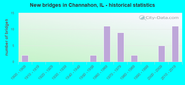
- New bridges - historical statistics
- 21900-1909
- 21950-1959
- 111960-1969
- 91970-1979
- 21980-1989
- 52000-2009
- 112010-2019

- Reconstructed bridges - Historical Statistics
- 31980-1989
- 21990-1999
- 12000-2009
- 12010-2019


- Bridge Condition - Deck
- 10.7%Very good
- 28.6%Good
- 25.0%Satisfactory
- 14.3%Fair
- 10.7%Poor
- 10.7%Serious

- Bridge Condition - Superstructure
- 21.4%Very good
- 21.4%Good
- 17.9%Satisfactory
- 10.7%Fair
- 17.9%Poor
- 10.7%Serious

- Bridge Condition - Substructure
- 25.0%Very good
- 32.1%Good
- 14.3%Satisfactory
- 17.9%Fair
- 7.1%Poor
- 3.6%Critical

- Bridge Condition - Channel
- 10.0%Excellent
- 35.0%Very good
- 40.0%Good
- 15.0%Satisfactory

- Bridge Condition - Culverts
- 33.3%Very good
- 33.3%Good
- 33.3%Satisfactory
Find on map >> Show street view
Structure Number: 320059, Location: 4.48 MI E OF ILL 47 (Lat: 41.427531, Lng: -88.353139), Route carried "on" structure: County highway , Year Built: 1960, Status: Open, Structure Length: 7.01m (23.00ft), Average Daily Traffic: 350 (year 2019), Truck Traffic: 8%, Average Future Daily Traffic: 370 (year 2032), Design Load: HS 15, Features Intersected: FAI 80, Facility Carried by Structure: Brown Rd / TR 150
Minimum Vertical Clearance: 30+ m (98+ ft), Kilometerpoint: 1.996, Lanes on structure: 2, Lanes under structure: 4, Owner: State Highway Agency, Approaching Roadway Width: 5.5m (18.0ft), Skew: 5 degrees, Material/Design: Prestressed concrete, Design/Construction: Stringer/Multi-beam, Number Of Spans In Main Unit: 4, Length of Maximum Span: 19.9m (65.3ft), Curb-To-Curb Width: 7.3m (24.0ft), Out-to-Out Width: 9.2m (30.2ft)
Condition: Deck: Poor, Superstructure: Poor, Substructure: Fair, Operating Rating: 89.1 metric tons, Method Used To Determine Operating Rating: Load Factor (LF) rating reported by rating factor (RF) method using MS18 loading, Inventory Rating: 54.1 metric tons, Method Used To Determine Inventory Rating: Load Factor (LF) rating reported by rating factor (RF) method using MS18 loading, Structural Evaluation: Meets minimum limits, Deck Geometry: Somewhat better than minimum adequacy, Underclear: High priority of corrective action, Approach Roadway Alignment: Equal to present minimum criteria, Designated Inspection Frequency: Every 12 months, Inspection Date: March 2021, Deck Structure Type: Concrete Cast-file-Place
Find on map >> Show street view
Structure Number: 320075, Location: 5.27 E OF ROUTE 47 (Lat: 41.417203, Lng: -88.337717), Route carried "on" structure: US 6, Year Built: 1974, Status: Open, Structure Length: 7.44m (24.41ft), Average Daily Traffic: 5,950 (year 2021), Truck Traffic: 12%, Average Future Daily Traffic: 7,738 (year 2032), Design Load: HS 20, Features Intersected: CSX Railroad
Minimum Vertical Clearance: 30+ m (98+ ft), Kilometerpoint: 208.807, Lanes on structure: 2, Base Highway Network: Yes, Owner: State Highway Agency, Approaching Roadway Width: 13.4m (44.0ft), Skew: 5 degrees, Material/Design: Steel continuous, Design/Construction: Stringer/Multi-beam, Number Of Spans In Main Unit: 3, Length of Maximum Span: 28.0m (91.9ft), Curb-To-Curb Width: 13.0m (42.7ft), Out-to-Out Width: 14.0m (45.9ft)
Condition: Deck: Serious, Superstructure: Poor, Substructure: Poor, Operating Rating: 48.9 metric tons, Method Used To Determine Operating Rating: Load Factor (LF) rating reported by rating factor (RF) method using MS18 loading, Inventory Rating: 29.5 metric tons, Method Used To Determine Inventory Rating: Load Factor (LF) rating reported by rating factor (RF) method using MS18 loading, Structural Evaluation: Meets minimum limits, Deck Geometry: Somewhat better than minimum adequacy, Underclear: Better than present minimum criteria, Approach Roadway Alignment: Equal to present desirable criteria, Designated Inspection Frequency: Every 12 months, Inspection Date: August 2021, Deck Structure Type: Concrete Cast-file-Place, Wearing Surface/Protective System: Wearing Surface: Bituminous, Membrane: Built-up
Find on map >> Show street view
Structure Number: 320101, Location: 4.63 MI E OF ILL 47 (Lat: 41.429150, Lng: -88.350264), Route carried "on" structure: Interstate 80, Year Built: 2003, Status: Open, Structure Length: 2.65m (8.69ft), Average Daily Traffic: 36,900 (year 2021), Truck Traffic: 30%, Average Future Daily Traffic: 43,813 (year 2032), Design Load: HS 20+Mod, Features Intersected: WALLEY RUN CR
Minimum Vertical Clearance: 30+ m (98+ ft), Kilometerpoint: 187.886, Lanes on structure: 4, Base Highway Network: Yes, Owner: State Highway Agency, Approaching Roadway Width: 16.2m (53.1ft), Skew: 33 degrees, Material/Design: Prestressed concrete, Design/Construction: Stringer/Multi-beam, Number Of Spans In Main Unit: 1, Length of Maximum Span: 23.8m (78.1ft), Curb-To-Curb Width: 36.0m (118.1ft), Out-to-Out Width: 38.0m (124.7ft)
Condition: Deck: Good, Superstructure: Very good, Substructure: Very good, Channel: Very good, Operating Rating: 76.1 metric tons, Method Used To Determine Operating Rating: Load Factor (LF) rating reported by rating factor (RF) method using MS18 loading, Inventory Rating: 47.3 metric tons, Method Used To Determine Inventory Rating: Load Factor (LF) rating reported by rating factor (RF) method using MS18 loading, Structural Evaluation: Equal to present desirable criteria, Deck Geometry: Superior to present desirable criteria, Waterway Adequacy: Equal to present desirable criteria, Approach Roadway Alignment: Equal to present desirable criteria, Designated Inspection Frequency: Every 24 months, Inspection Date: March 2021, Deck Structure Type: Concrete Cast-file-Place, Wearing Surface/Protective System: Deck Protection: Epoxy Coated Reinforcing
Find on map >> Show street view
Structure Number: 320103, Location: 4.7MI E I 80 IL 47 (Lat: 41.428508, Lng: -88.350825), Route carried "on" structure: County highway , Year Built: 2003, Status: Open, Structure Length: 2.32m (7.61ft), Average Daily Traffic: 800 (year 2019), Truck Traffic: 8%, Average Future Daily Traffic: 1,707 (year 2032), Design Load: HS 20, Features Intersected: WALLEY RUN CREEK, Facility Carried by Structure: TR 17(FR)
Minimum Vertical Clearance: 30+ m (98+ ft), Kilometerpoint: 0.370, Lanes on structure: 2, Owner: Town or Township Highway Agency, Approaching Roadway Width: 8.4m (27.6ft), Skew: 3 degrees, Material/Design: Prestressed concrete, Design/Construction: Stringer/Multi-beam, Number Of Spans In Main Unit: 1, Length of Maximum Span: 23.2m (76.1ft), Curb-To-Curb Width: 8.4m (27.6ft), Out-to-Out Width: 9.4m (30.8ft)
Condition: Deck: Very good, Superstructure: Very good, Substructure: Very good, Channel: Very good, Operating Rating: 68.7 metric tons, Method Used To Determine Operating Rating: Load Factor (LF) rating reported by rating factor (RF) method using MS18 loading, Inventory Rating: 36.6 metric tons, Method Used To Determine Inventory Rating: Load Factor (LF) rating reported by rating factor (RF) method using MS18 loading, Structural Evaluation: Equal to present desirable criteria, Deck Geometry: Somewhat better than minimum adequacy, Waterway Adequacy: Equal to present desirable criteria, Approach Roadway Alignment: Equal to present desirable criteria, Designated Inspection Frequency: Every 48 months, Inspection Date: October 2018, Deck Structure Type: Concrete Cast-file-Place, Wearing Surface/Protective System: Deck Protection: Epoxy Coated Reinforcing
Find on map >> Show street view
Structure Number: 320104, Location: 3.93 MI E OF ILL 47 (Lat: 41.422750, Lng: -88.361644), Route carried "on" structure: Interstate 80, Year Built: 2003, Status: Open, Structure Length: 3.19m (10.47ft), Average Daily Traffic: 36,900 (year 2021), Truck Traffic: 30%, Average Future Daily Traffic: 43,813 (year 2032), Design Load: HS 20+Mod, Features Intersected: COLLINS RUN CREEK
Minimum Vertical Clearance: 30+ m (98+ ft), Kilometerpoint: 186.759, Lanes on structure: 4, Base Highway Network: Yes, Owner: State Highway Agency, Approaching Roadway Width: 19.0m (62.3ft), Skew: 31 degrees, Material/Design: Prestressed concrete, Design/Construction: Stringer/Multi-beam, Number Of Spans In Main Unit: 1, Length of Maximum Span: 31.0m (101.7ft), Curb-To-Curb Width: 36.0m (118.1ft), Out-to-Out Width: 38.0m (124.7ft)
Condition: Deck: Good, Superstructure: Very good, Substructure: Very good, Channel: Very good, Operating Rating: 79.4 metric tons, Method Used To Determine Operating Rating: Load Factor (LF) rating reported by rating factor (RF) method using MS18 loading, Inventory Rating: 47.6 metric tons, Method Used To Determine Inventory Rating: Load Factor (LF) rating reported by rating factor (RF) method using MS18 loading, Structural Evaluation: Equal to present desirable criteria, Deck Geometry: Superior to present desirable criteria, Waterway Adequacy: Equal to present desirable criteria, Approach Roadway Alignment: Equal to present desirable criteria, Designated Inspection Frequency: Every 24 months, Inspection Date: Febuary 2020, Deck Structure Type: Concrete Cast-file-Place, Wearing Surface/Protective System: Deck Protection: Epoxy Coated Reinforcing
Find on map >> Show street view
Structure Number: 320115, Location: 3.72 MI E OF ILL 47 (Lat: 41.421086, Lng: -88.364889), Route carried "on" structure: Other road , Year Built: 2011, Status: Open, Structure Length: 7.66m (25.13ft), Average Daily Traffic: 1,825 (year 2019), Truck Traffic: 18%, Average Future Daily Traffic: 1,000 (year 2032), Design Load: HS 25 or greater, Features Intersected: FAI 80, Facility Carried by Structure: BRISBIN RD (FAU 40
Minimum Vertical Clearance: 30+ m (98+ ft), Kilometerpoint: 2.736, Lanes on structure: 2, Lanes under structure: 4, Owner: State Highway Agency, Approaching Roadway Width: 21.9m (71.9ft), Skew: 33 degrees, Material/Design: Steel continuous, Design/Construction: Stringer/Multi-beam, Number Of Spans In Main Unit: 2, Length of Maximum Span: 37.0m (121.4ft), Curb-To-Curb Width: 21.9m (71.9ft), Out-to-Out Width: 24.7m (81.0ft)
Condition: Deck: Good, Superstructure: Good, Substructure: Very good, Operating Rating: 62.9 metric tons, Method Used To Determine Operating Rating: Load and Resistance Factor Rating (LRFR) rating reported by rating factor(RF) method using HL-93 loadings, Inventory Rating: 48.6 metric tons, Method Used To Determine Inventory Rating: Load and Resistance Factor Rating (LRFR) rating reported by rating factor(RF) method using HL-93 loadings, Structural Evaluation: Better than present minimum criteria, Deck Geometry: Superior to present desirable criteria, Approach Roadway Alignment: Equal to present desirable criteria, Designated Inspection Frequency: Every 24 months, Inspection Date: March 2021, Deck Structure Type: Concrete Cast-file-Place, Wearing Surface/Protective System: Deck Protection: Epoxy Coated Reinforcing
Find on map >> Show street view
Structure Number: 320117, Location: SE QUAD I-80/BRISBIN (Lat: 41.422633, Lng: -88.361156), Route carried "on" structure: Other road , Year Built: 2011, Status: Open, Structure Length: 3.41m (11.19ft), Average Daily Traffic: 1,050 (year 2019), Truck Traffic: 24%, Average Future Daily Traffic: 5,000 (year 2032), Design Load: HS 25 or greater, Features Intersected: COLLINS RUN, Facility Carried by Structure: I-80EB Entrance Ra
Minimum Vertical Clearance: 30+ m (98+ ft), Kilometerpoint: 0.483, Lanes on structure: 1, Base Highway Network: Yes (Inventory Route: 10080041, Subroute: 90), Owner: State Highway Agency, Approaching Roadway Width: 7.9m (25.9ft), Skew: 1 degrees, Material/Design: Prestressed concrete, Design/Construction: Stringer/Multi-beam, Number Of Spans In Main Unit: 1, Length of Maximum Span: 33.2m (108.9ft), Curb-To-Curb Width: 8.2m (26.9ft), Out-to-Out Width: 9.2m (30.2ft)
Condition: Deck: Good, Superstructure: Very good, Substructure: Very good, Channel: Very good, Operating Rating: 61.6 metric tons, Method Used To Determine Operating Rating: Load and Resistance Factor Rating (LRFR) rating reported by rating factor(RF) method using HL-93 loadings, Inventory Rating: 47.3 metric tons, Method Used To Determine Inventory Rating: Load and Resistance Factor Rating (LRFR) rating reported by rating factor(RF) method using HL-93 loadings, Structural Evaluation: Equal to present desirable criteria, Deck Geometry: Meets minimum limits, Waterway Adequacy: Equal to present desirable criteria, Approach Roadway Alignment: Equal to present desirable criteria, Designated Inspection Frequency: Every 24 months, Inspection Date: March 2021, Deck Structure Type: Concrete Cast-file-Place, Wearing Surface/Protective System: Deck Protection: Epoxy Coated Reinforcing
Find on map >> Show street view
Structure Number: 320118, Location: NE QUAD I-80/BRISBIN (Lat: 41.423072, Lng: -88.361722), Route carried "on" structure: Other road , Year Built: 2011, Status: Open, Structure Length: 3.15m (10.33ft), Average Daily Traffic: 1,350 (year 2019), Truck Traffic: 16%, Average Future Daily Traffic: 358 (year 2037), Design Load: HS 25 or greater, Features Intersected: COLLINS RUN, Facility Carried by Structure: I-80 WB Exit Ramp
Minimum Vertical Clearance: 30+ m (98+ ft), Kilometerpoint: 0.257, Lanes on structure: 1, Base Highway Network: Yes (Inventory Route: 10080041, Subroute: 30), Owner: State Highway Agency, Approaching Roadway Width: 7.9m (25.9ft), Skew: 1 degrees, Material/Design: Prestressed concrete, Design/Construction: Stringer/Multi-beam, Number Of Spans In Main Unit: 1, Length of Maximum Span: 30.6m (100.4ft), Curb-To-Curb Width: 7.9m (25.9ft), Out-to-Out Width: 8.9m (29.2ft)
Condition: Deck: Good, Superstructure: Very good, Substructure: Very good, Channel: Very good, Operating Rating: 64.2 metric tons, Method Used To Determine Operating Rating: Load and Resistance Factor Rating (LRFR) rating reported by rating factor(RF) method using HL-93 loadings, Inventory Rating: 49.6 metric tons, Method Used To Determine Inventory Rating: Load and Resistance Factor Rating (LRFR) rating reported by rating factor(RF) method using HL-93 loadings, Structural Evaluation: Equal to present desirable criteria, Deck Geometry: Meets minimum limits, Waterway Adequacy: Equal to present desirable criteria, Approach Roadway Alignment: Equal to present desirable criteria, Designated Inspection Frequency: Every 24 months, Inspection Date: March 2021, Deck Structure Type: Concrete Cast-file-Place, Wearing Surface/Protective System: Deck Protection: Epoxy Coated Reinforcing
Find on map >> Show street view
Structure Number: 323911, Location: 1.43 MI S MINOOKA RD (Lat: 41.425250, Lng: -88.365025), Route carried "on" structure: Other road , Year Built: 1978, Status: Open, Structure Length: 2.87m (9.42ft), Average Daily Traffic: 1,100 (year 2019), Truck Traffic: 9%, Average Future Daily Traffic: 398 (year 2032), Design Load: HS 20, Features Intersected: COLLINS RUN, Facility Carried by Structure: BRISBIN RD FAU401
Minimum Vertical Clearance: 30+ m (98+ ft), Kilometerpoint: 2.301, Lanes on structure: 2, Owner: County Highway Agency, Approaching Roadway Width: 7.3m (24.0ft), Material/Design: Concrete, Design/Construction: Channel Beam, Number Of Spans In Main Unit: 3, Length of Maximum Span: 9.8m (32.2ft), Curb-To-Curb Width: 7.4m (24.3ft), Out-to-Out Width: 8.0m (26.2ft)
Condition: Deck: Serious, Superstructure: Serious, Substructure: Satisfactory, Channel: Good, Operating Rating: 46.7 metric tons, Method Used To Determine Operating Rating: Load Factor (LF) rating reported by rating factor (RF) method using MS18 loading, Inventory Rating: 27.9 metric tons, Method Used To Determine Inventory Rating: Load Factor (LF) rating reported by rating factor (RF) method using MS18 loading, Structural Evaluation: High priority of corrective action, Deck Geometry: Meets minimum limits, Waterway Adequacy: Somewhat better than minimum adequacy, Approach Roadway Alignment: Better than present minimum criteria, Designated Inspection Frequency: Every 24 months, Inspection Date: October 2020, Deck Structure Type: Concrete Precast Panels
Find on map >> Show street view
Structure Number: 323916, Location: .15 MI E BRISBIN RD (Lat: 41.423614, Lng: -88.362133), Route carried "on" structure: County highway , Year Built: 1976, Status: Open, Structure Length: 2.99m (9.81ft), Average Daily Traffic: 375 (year 2019), Truck Traffic: 7%, Average Future Daily Traffic: 398 (year 2032), Design Load: HS 20, Features Intersected: COLLINS RUN, Facility Carried by Structure: NORTH RD TR-11
Minimum Vertical Clearance: 30+ m (98+ ft), Kilometerpoint: 0.306, Lanes on structure: 2, Owner: Town or Township Highway Agency, Approaching Roadway Width: 7.3m (24.0ft), Skew: 2 degrees, Material/Design: Concrete, Design/Construction: Channel Beam, Number Of Spans In Main Unit: 3, Length of Maximum Span: 9.8m (32.2ft), Curb-To-Curb Width: 7.4m (24.3ft), Out-to-Out Width: 8.0m (26.2ft)
Condition: Deck: Fair, Superstructure: Serious, Substructure: Satisfactory, Channel: Satisfactory, Operating Rating: 46.0 metric tons, Method Used To Determine Operating Rating: Load Factor (LF) rating reported by rating factor (RF) method using MS18 loading, Inventory Rating: 27.5 metric tons, Method Used To Determine Inventory Rating: Load Factor (LF) rating reported by rating factor (RF) method using MS18 loading, Structural Evaluation: High priority of corrective action, Deck Geometry: Somewhat better than minimum adequacy, Waterway Adequacy: Somewhat better than minimum adequacy, Approach Roadway Alignment: Equal to present desirable criteria, Designated Inspection Frequency: Every 24 months, Inspection Date: July 2021, Deck Structure Type: Concrete Precast Panels, Wearing Surface/Protective System: Wearing Surface: Bituminous
Find on map >> Show street view
Structure Number: 323921, Location: W. OF MCLINDON RD (Lat: 41.404742, Lng: -88.290125), Route carried "on" structure: County highway , Year Built: 1984, Status: Open, Structure Length: 2.32m (7.61ft), Average Daily Traffic: 400 (year 2019), Truck Traffic: 3%, Average Future Daily Traffic: 512 (year 2032), Design Load: HS 20, Features Intersected: I&M CANAL, Facility Carried by Structure: TR 25A CEMETERY RD
Minimum Vertical Clearance: 30+ m (98+ ft), Kilometerpoint: 0.386, Lanes on structure: 2, Owner: Town or Township Highway Agency, Approaching Roadway Width: 7.9m (25.9ft), Skew: 3 degrees, Material/Design: Prestressed concrete, Design/Construction: Box Beam or Girders - Multiple, Number Of Spans In Main Unit: 2, Length of Maximum Span: 15.2m (49.9ft), Curb-To-Curb Width: 8.0m (26.2ft), Out-to-Out Width: 8.2m (26.9ft)
Condition: Deck: Satisfactory, Superstructure: Satisfactory, Substructure: Good, Channel: Very good, Operating Rating: 59.6 metric tons, Method Used To Determine Operating Rating: Load Factor (LF) rating reported by rating factor (RF) method using MS18 loading, Inventory Rating: 35.6 metric tons, Method Used To Determine Inventory Rating: Load Factor (LF) rating reported by rating factor (RF) method using MS18 loading, Structural Evaluation: Equal to present minimum criteria, Deck Geometry: Somewhat better than minimum adequacy, Waterway Adequacy: Equal to present desirable criteria, Approach Roadway Alignment: Equal to present desirable criteria, Designated Inspection Frequency: Every 24 months, Inspection Date: October 2020, Deck Structure Type: Concrete Precast Panels, Wearing Surface/Protective System: Wearing Surface: Bituminous
Find on map >> Show street view
Structure Number: 32393, Location: .02 MI NO CEMETERY R (Lat: 41.396850, Lng: -88.328208), Route carried "on" structure: County highway , Year Built: 1961, Status: Open, Structure Length: 1.04m (3.41ft), Average Daily Traffic: 500 (year 2019), Truck Traffic: 24%, Average Future Daily Traffic: 683 (year 2032), Features Intersected: I & M CANAL, Facility Carried by Structure: TR-174A TABLER RD
Minimum Vertical Clearance: 30+ m (98+ ft), Kilometerpoint: 2.848, Lanes on structure: 2, Owner: Town or Township Highway Agency, Approaching Roadway Width: 7.3m (24.0ft), Material/Design: Concrete, Design/Construction: Slab, Number Of Spans In Main Unit: 1, Length of Maximum Span: 9.8m (32.2ft), Curb-To-Curb Width: 7.4m (24.3ft), Out-to-Out Width: 8.6m (28.2ft)
Condition: Deck: Satisfactory, Superstructure: Good, Substructure: Critical, Channel: Good, Operating Rating: 40.5 metric tons, Method Used To Determine Operating Rating: Field evaluation and documented engineering judgment, Inventory Rating: 24.3 metric tons, Method Used To Determine Inventory Rating: Field evaluation and documented engineering judgment, Structural Evaluation: High priority of replacement, Deck Geometry: Meets minimum limits, Waterway Adequacy: Equal to present minimum criteria, Approach Roadway Alignment: Equal to present minimum criteria, Designated Inspection Frequency: Every 24 months, Inspection Date: October 2021, Deck Structure Type: Concrete Cast-file-Place, Wearing Surface/Protective System: Wearing Surface: Bituminous
Find on map >> Show street view
Structure Number: 323941, Location: .13 MI W TABLER RD (Lat: 41.395564, Lng: -88.330192), Route carried "on" structure: County highway , Year Built: 1979, Status: Posted for load, Structure Length: 4.27m (14.01ft), Average Daily Traffic: 650 (year 2019), Truck Traffic: 5%, Average Future Daily Traffic: 797 (year 2032), Design Load: HS 20, Features Intersected: AUX SABLE CR, Facility Carried by Structure: CEMETERY RD TR-25
Minimum Vertical Clearance: 30+ m (98+ ft), Kilometerpoint: 5.954, Lanes on structure: 2, Owner: Town or Township Highway Agency, Approaching Roadway Width: 7.3m (24.0ft), Material/Design: Prestressed concrete, Design/Construction: Box Beam or Girders - Multiple, Number Of Spans In Main Unit: 3, Length of Maximum Span: 14.0m (45.9ft), Curb-To-Curb Width: 7.3m (24.0ft), Out-to-Out Width: 7.3m (24.0ft)
Condition: Deck: Poor, Superstructure: Poor, Substructure: Good, Channel: Good, Operating Rating: 33.4 metric tons, Method Used To Determine Operating Rating: Load Factor (LF) rating reported by rating factor (RF) method using MS18 loading, Inventory Rating: 19.8 metric tons, Method Used To Determine Inventory Rating: Load Factor (LF) rating reported by rating factor (RF) method using MS18 loading, Structural Evaluation: Meets minimum limits, Deck Geometry: Meets minimum limits, Waterway Adequacy: Equal to present desirable criteria, Approach Roadway Alignment: Equal to present desirable criteria, Bridge Posting: Required (Relationship of Operating Rating to Maximum Legal Load: 30.0 - 39.9% below), Designated Inspection Frequency: Every 24 months, Inspection Date: October 2020, Deck Structure Type: Concrete Precast Panels, Wearing Surface/Protective System: Wearing Surface: Bituminous
Find on map >> Show street view
Structure Number: 3245, Location: 2 MI N PINE BLUFF RD (Lat: 41.372131, Lng: -88.268378), Route carried "on" structure: County highway , Year Built: 1975, Status: Posted for load, Structure Length: 11.99m (39.34ft), Average Daily Traffic: 1,750 (year 2019), Truck Traffic: 6%, Average Future Daily Traffic: 2,162 (year 2032), Design Load: HS 20, Features Intersected: Com.Ed.Flumes, Facility Carried by Structure: TR-204 Dresden Rd
Minimum Vertical Clearance: 30+ m (98+ ft), Kilometerpoint: 1.143, Lanes on structure: 2, Owner: Town or Township Highway Agency, Approaching Roadway Width: 8.5m (27.9ft), Skew: 4 degrees, Material/Design: Concrete, Design/Construction: Channel Beam, Number Of Spans In Main Unit: 13, Length of Maximum Span: 8.8m (28.9ft), Curb-To-Curb Width: 9.7m (31.8ft), Out-to-Out Width: 10.3m (33.8ft)
Condition: Deck: Serious, Superstructure: Serious, Substructure: Poor, Channel: Satisfactory, Operating Rating: 41.8 metric tons, Method Used To Determine Operating Rating: Load Factor (LF) rating reported by rating factor (RF) method using MS18 loading, Inventory Rating: 21.7 metric tons, Method Used To Determine Inventory Rating: Load Factor (LF) rating reported by rating factor (RF) method using MS18 loading, Structural Evaluation: High priority of corrective action, Deck Geometry: Somewhat better than minimum adequacy, Waterway Adequacy: Equal to present desirable criteria, Approach Roadway Alignment: Equal to present desirable criteria, Designated Inspection Frequency: Every 24 months, Inspection Date: November 2021, Deck Structure Type: Concrete Precast Panels, Wearing Surface/Protective System: Wearing Surface: Bituminous
Find on map >> Show street view
Structure Number: 990008, Location: 2.3 M S OF US 6 (Lat: 41.419814, Lng: -88.194350), Route carried "on" structure: Interstate 55, Year Built: 1957, Year Reconstructed: 2002, Status: Open, Structure Length: 42.85m (140.58ft), Average Daily Traffic: 25,650 (year 2021), Truck Traffic: 6%, Average Future Daily Traffic: 36,073 (year 2032), Features Intersected: DES PLAINES RIVER
Minimum Vertical Clearance: 5.33m (17.49ft), Kilometerpoint: 395.469, Lanes on structure: 2, Base Highway Network: Yes, Owner: State Highway Agency, Approaching Roadway Width: 9.9m (32.5ft), Navigation Control: Yes ( Vertical Clearance: 14.3m (46.9ft), Horizontal Clearance: 106.7m (350.1ft)), Material/Design: Steel continuous, Design/Construction: Truss - Thru, Number Of Spans In Main Unit: 3, Number Of Approach Spans: 4, Length of Maximum Span: 148.1m (485.9ft), Curb-To-Curb Width: 9.9m (32.5ft), Out-to-Out Width: 10.9m (35.8ft)
Condition: Deck: Fair, Superstructure: Fair, Substructure: Fair, Channel: Good, Operating Rating: 49.6 metric tons, Method Used To Determine Operating Rating: Load Factor (LF) rating reported by rating factor (RF) method using MS18 loading, Inventory Rating: 29.8 metric tons, Method Used To Determine Inventory Rating: Load Factor (LF) rating reported by rating factor (RF) method using MS18 loading, Structural Evaluation: Somewhat better than minimum adequacy, Deck Geometry: Meets minimum limits, Waterway Adequacy: Equal to present desirable criteria, Approach Roadway Alignment: Equal to present desirable criteria, Designated Inspection Frequency: Every 24 months, Critical Feature Inspection Frequency: Every 24 months, Underwater Inspection Frequency: Every 60 months, Inspection Date: August 2021, Critical Feature Inspection Date: August 2021, Underwater Inspection Date: August 2021, Deck Structure Type: Closed Grating, Wearing Surface/Protective System: Wearing Surface: Bituminous, Membrane: Built-up
Find on map >> Show street view
Structure Number: 990009, Location: 2.3 M S OF US 6 (Lat: 41.420039, Lng: -88.194358), Route carried "on" structure: Interstate 55, Year Built: 1957, Year Reconstructed: 2002, Status: Open, Structure Length: 42.85m (140.58ft), Average Daily Traffic: 25,650 (year 2021), Truck Traffic: 6%, Average Future Daily Traffic: 36,073 (year 2032), Features Intersected: DES PLAINES RIVER
Minimum Vertical Clearance: 5.33m (17.49ft), Kilometerpoint: 395.502, Lanes on structure: 2, Base Highway Network: Yes, Owner: State Highway Agency, Approaching Roadway Width: 9.9m (32.5ft), Navigation Control: Yes ( Vertical Clearance: 14.3m (46.9ft), Horizontal Clearance: 106.7m (350.1ft)), Material/Design: Steel continuous, Design/Construction: Truss - Thru, Number Of Spans In Main Unit: 3, Number Of Approach Spans: 4, Length of Maximum Span: 148.1m (485.9ft), Curb-To-Curb Width: 9.9m (32.5ft), Out-to-Out Width: 10.9m (35.8ft)
Condition: Deck: Fair, Superstructure: Fair, Substructure: Fair, Channel: Good, Operating Rating: 49.6 metric tons, Method Used To Determine Operating Rating: Load Factor (LF) rating reported by rating factor (RF) method using MS18 loading, Inventory Rating: 29.8 metric tons, Method Used To Determine Inventory Rating: Load Factor (LF) rating reported by rating factor (RF) method using MS18 loading, Structural Evaluation: Somewhat better than minimum adequacy, Deck Geometry: Meets minimum limits, Waterway Adequacy: Equal to present desirable criteria, Approach Roadway Alignment: Equal to present desirable criteria, Designated Inspection Frequency: Every 24 months, Critical Feature Inspection Frequency: Every 24 months, Underwater Inspection Frequency: Every 60 months, Inspection Date: August 2021, Critical Feature Inspection Date: August 2021, Underwater Inspection Date: August 2021, Deck Structure Type: Closed Grating, Wearing Surface/Protective System: Wearing Surface: Bituminous, Membrane: Built-up
Find on map >> Show street view
Structure Number: 990042, Location: 0.25 M W OF I-55 (Lat: 41.485858, Lng: -88.204264), Route carried "on" structure: Interstate 80, Year Built: 1960, Year Reconstructed: 2005, Status: Open, Structure Length: 0.85m (2.79ft), Average Daily Traffic: 28,700 (year 2019), Truck Traffic: 24%, Average Future Daily Traffic: 30,642 (year 2032), Design Load: HS 20+Mod, Features Intersected: FRONTAGE ROAD
Minimum Vertical Clearance: 30+ m (98+ ft), Kilometerpoint: 202.675, Lanes on structure: 2, Lanes under structure: 2, Base Highway Network: Yes, Owner: State Highway Agency, Approaching Roadway Width: 14.0m (45.9ft), Material/Design: Concrete, Design/Construction: Slab, Number Of Spans In Main Unit: 1, Length of Maximum Span: 8.3m (27.2ft), Curb-To-Curb Width: 19.6m (64.3ft), Out-to-Out Width: 20.6m (67.6ft)
Condition: Deck: Satisfactory, Superstructure: Satisfactory, Substructure: Good, Operating Rating: 78.4 metric tons, Method Used To Determine Operating Rating: Load Factor (LF) rating reported by rating factor (RF) method using MS18 loading, Inventory Rating: 47.0 metric tons, Method Used To Determine Inventory Rating: Load Factor (LF) rating reported by rating factor (RF) method using MS18 loading, Structural Evaluation: Equal to present minimum criteria, Deck Geometry: Superior to present desirable criteria, Approach Roadway Alignment: Equal to present desirable criteria, Designated Inspection Frequency: Every 24 months, Inspection Date: September 2021, Deck Structure Type: Concrete Cast-file-Place, Wearing Surface/Protective System: Wearing Surface: Other
Find on map >> Show street view
Structure Number: 990043, Location: 0.25 M WEST OF I-55 (Lat: 41.485878, Lng: -88.203992), Route carried "on" structure: Interstate 80, Year Built: 1960, Status: Open, Structure Length: 0.85m (2.79ft), Average Daily Traffic: 28,700 (year 2019), Truck Traffic: 24%, Average Future Daily Traffic: 30,642 (year 2032), Design Load: HS 20+Mod, Features Intersected: FRONTAGE ROAD
Minimum Vertical Clearance: 30+ m (98+ ft), Kilometerpoint: 202.691, Lanes on structure: 2, Lanes under structure: 2, Base Highway Network: Yes, Owner: State Highway Agency, Approaching Roadway Width: 13.6m (44.6ft), Material/Design: Concrete, Design/Construction: Slab, Number Of Spans In Main Unit: 1, Length of Maximum Span: 8.3m (27.2ft), Curb-To-Curb Width: 13.6m (44.6ft), Out-to-Out Width: 14.5m (47.6ft)
Condition: Deck: Satisfactory, Superstructure: Satisfactory, Substructure: Good, Operating Rating: 78.1 metric tons, Method Used To Determine Operating Rating: Load Factor (LF) rating reported by rating factor (RF) method using MS18 loading, Inventory Rating: 47.0 metric tons, Method Used To Determine Inventory Rating: Load Factor (LF) rating reported by rating factor (RF) method using MS18 loading, Structural Evaluation: Equal to present minimum criteria, Deck Geometry: Superior to present desirable criteria, Underclear: High priority of corrective action, Approach Roadway Alignment: Equal to present desirable criteria, Designated Inspection Frequency: Every 24 months, Inspection Date: September 2021, Deck Structure Type: Concrete Cast-file-Place, Wearing Surface/Protective System: Wearing Surface: Other
Find on map >> Show street view
Structure Number: 990044, Location: 4 M E GRUNDY CO LIN (Lat: 41.486211, Lng: -88.197539), Route carried "on" structure: Interstate 80, Year Built: 1960, Year Reconstructed: 1993, Status: Open, Structure Length: 7.29m (23.92ft), Average Daily Traffic: 28,700 (year 2019), Truck Traffic: 24%, Average Future Daily Traffic: 30,642 (year 2032), Design Load: HS 20+Mod, Features Intersected: I- 55
Minimum Vertical Clearance: 30+ m (98+ ft), Kilometerpoint: 203.190, Lanes on structure: 3, Lanes under structure: 6, Base Highway Network: Yes, Owner: State Highway Agency, Approaching Roadway Width: 16.5m (54.1ft), Material/Design: Steel continuous, Design/Construction: Stringer/Multi-beam, Number Of Spans In Main Unit: 4, Length of Maximum Span: 22.5m (73.8ft), Curb-To-Curb Width: 14.6m (47.9ft), Out-to-Out Width: 15.6m (51.2ft)
Condition: Deck: Fair, Superstructure: Poor, Substructure: Satisfactory, Operating Rating: 59.3 metric tons, Method Used To Determine Operating Rating: Load Factor (LF) rating reported by rating factor (RF) method using MS18 loading, Inventory Rating: 35.3 metric tons, Method Used To Determine Inventory Rating: Load Factor (LF) rating reported by rating factor (RF) method using MS18 loading, Structural Evaluation: Meets minimum limits, Deck Geometry: Meets minimum limits, Underclear: High priority of corrective action, Approach Roadway Alignment: Equal to present desirable criteria, Length Of Structure Improvement: 7.19m (23.59ft), Designated Inspection Frequency: Every 12 months, Other Special Inspection Frequency: Every 48 months, Inspection Date: August 2021, Other Special Inspection Date: August 2018, Bridge Improvement Cost: $871,000, Roadway Improvement Cost: $87,000, Total Project Cost: $1,307,000, Deck Structure Type: Concrete Cast-file-Place, Wearing Surface/Protective System: Deck Protection: Epoxy Coated Reinforcing
Find on map >> Show street view
Structure Number: 990045, Location: 4 M E GRUNDY CO LIN (Lat: 41.486211, Lng: -88.197300), Route carried "on" structure: Interstate 80, Year Built: 1960, Year Reconstructed: 1993, Status: Open, Structure Length: 7.29m (23.92ft), Average Daily Traffic: 31,300 (year 2021), Truck Traffic: 25%, Average Future Daily Traffic: 33,793 (year 2032), Design Load: HS 20+Mod, Features Intersected: I- 55
Minimum Vertical Clearance: 30+ m (98+ ft), Kilometerpoint: 203.206, Lanes on structure: 3, Lanes under structure: 6, Base Highway Network: Yes, Owner: State Highway Agency, Approaching Roadway Width: 16.5m (54.1ft), Material/Design: Steel continuous, Design/Construction: Stringer/Multi-beam, Number Of Spans In Main Unit: 4, Length of Maximum Span: 22.5m (73.8ft), Curb-To-Curb Width: 14.6m (47.9ft), Out-to-Out Width: 15.6m (51.2ft)
Condition: Deck: Satisfactory, Superstructure: Fair, Substructure: Satisfactory, Operating Rating: 64.2 metric tons, Method Used To Determine Operating Rating: Load Factor (LF) rating reported by rating factor (RF) method using MS18 loading, Inventory Rating: 38.6 metric tons, Method Used To Determine Inventory Rating: Load Factor (LF) rating reported by rating factor (RF) method using MS18 loading, Structural Evaluation: Somewhat better than minimum adequacy, Deck Geometry: Meets minimum limits, Underclear: High priority of corrective action, Approach Roadway Alignment: Equal to present desirable criteria, Length Of Structure Improvement: 7.19m (23.59ft), Designated Inspection Frequency: Every 24 months, Other Special Inspection Frequency: Every 48 months, Inspection Date: September 2021, Other Special Inspection Date: August 2018, Bridge Improvement Cost: $871,000, Roadway Improvement Cost: $87,000, Total Project Cost: $1,307,000, Deck Structure Type: Concrete Cast-file-Place, Wearing Surface/Protective System: Deck Protection: Epoxy Coated Reinforcing
Find on map >> Show street view
Structure Number: 990308, Location: I-55SB TO I-80WB RMP (Lat: 41.486286, Lng: -88.203617), Route carried "on" structure: Other road , Year Built: 2005, Status: Open, Structure Length: 0.89m (2.92ft), Average Daily Traffic: 9,300 (year 2021), Truck Traffic: 22%, Average Future Daily Traffic: 4,828 (year 2032), Features Intersected: WEST FRONTAGE RD, Facility Carried by Structure: I- 55 SB TO I-80 W
Minimum Vertical Clearance: 30+ m (98+ ft), Kilometerpoint: 0.595, Lanes on structure: 1, Lanes under structure: 2, Base Highway Network: Yes (Inventory Route: 10080040, Subroute: 80), Owner: State Highway Agency, Approaching Roadway Width: 9.1m (29.9ft), Material/Design: Concrete, Design/Construction: Slab, Number Of Spans In Main Unit: 1, Length of Maximum Span: 8.6m (28.2ft), Curb-To-Curb Width: 9.1m (29.9ft), Out-to-Out Width: 10.1m (33.1ft)
Condition: Deck: Good, Superstructure: Good, Substructure: Good, Operating Rating: 89.1 metric tons, Method Used To Determine Operating Rating: Load Factor (LF) rating reported by rating factor (RF) method using MS18 loading, Inventory Rating: 62.5 metric tons, Method Used To Determine Inventory Rating: Load Factor (LF) rating reported by rating factor (RF) method using MS18 loading, Structural Evaluation: Better than present minimum criteria, Deck Geometry: High priority of corrective action, Underclear: Meets minimum limits, Approach Roadway Alignment: Equal to present desirable criteria, Designated Inspection Frequency: Every 24 months, Inspection Date: September 2021, Deck Structure Type: Concrete Cast-file-Place, Wearing Surface/Protective System: Deck Protection: Epoxy Coated Reinforcing
Find on map >> Show street view
Structure Number: 990347, Location: 2.6 M S OF I-80 (Lat: 41.417944, Lng: -88.193817), Route carried "on" structure: Other road , Year Built: 2012, Status: Open, Structure Length: 6.61m (21.69ft), Average Daily Traffic: 1,900 (year 2019), Truck Traffic: 11%, Average Future Daily Traffic: 3,000 (year 2037), Design Load: HS 25 or greater, Features Intersected: I- 55, Facility Carried by Structure: ARSENAL RD
Minimum Vertical Clearance: 30+ m (98+ ft), Kilometerpoint: 0.080, Lanes on structure: 2, Lanes under structure: 4, Base Highway Network: Yes, Owner: State Highway Agency, Approaching Roadway Width: 16.5m (54.1ft), Material/Design: Prestressed concrete continuous, Design/Construction: Stringer/Multi-beam, Number Of Spans In Main Unit: 2, Length of Maximum Span: 32.6m (107.0ft), Curb-To-Curb Width: 16.5m (54.1ft), Out-to-Out Width: 17.4m (57.1ft)
Condition: Deck: Good, Superstructure: Good, Substructure: Very good, Operating Rating: 60.6 metric tons, Method Used To Determine Operating Rating: Load and Resistance Factor Rating (LRFR) rating reported by rating factor(RF) method using HL-93 loadings, Inventory Rating: 46.7 metric tons, Method Used To Determine Inventory Rating: Load and Resistance Factor Rating (LRFR) rating reported by rating factor(RF) method using HL-93 loadings, Structural Evaluation: Better than present minimum criteria, Deck Geometry: Superior to present desirable criteria, Approach Roadway Alignment: Equal to present desirable criteria, Designated Inspection Frequency: Every 24 months, Inspection Date: January 2021, Deck Structure Type: Concrete Cast-file-Place, Wearing Surface/Protective System: Deck Protection: Epoxy Coated Reinforcing
Find on map >> Show street view
Structure Number: 990348, Location: 1.6mile S of Arsenal (Lat: 41.395231, Lng: -88.193536), Route carried "on" structure: Other road , Year Built: 2012, Status: Open, Structure Length: 6.68m (21.92ft), Average Daily Traffic: 6,200 (year 2021), Truck Traffic: 69%, Average Future Daily Traffic: 1,500 (year 2032), Design Load: HS 25 or greater, Features Intersected: I- 55, Facility Carried by Structure: I- 55 SB TO ARSENA
Minimum Vertical Clearance: 30+ m (98+ ft), Kilometerpoint: 0.692, Lanes on structure: 2, Lanes under structure: 6, Base Highway Network: Yes (Inventory Route: 10055041, Subroute: 60), Owner: State Highway Agency, Approaching Roadway Width: 18.0m (59.1ft), Skew: 3 degrees, Material/Design: Steel continuous, Design/Construction: Stringer/Multi-beam, Number Of Spans In Main Unit: 2, Length of Maximum Span: 33.4m (109.6ft), Curb-To-Curb Width: 18.0m (59.1ft), Out-to-Out Width: 19.0m (62.3ft)
Condition: Deck: Good, Superstructure: Good, Substructure: Good, Operating Rating: 62.9 metric tons, Method Used To Determine Operating Rating: Load and Resistance Factor Rating (LRFR) rating reported by rating factor(RF) method using HL-93 loadings, Inventory Rating: 48.6 metric tons, Method Used To Determine Inventory Rating: Load and Resistance Factor Rating (LRFR) rating reported by rating factor(RF) method using HL-93 loadings, Structural Evaluation: Better than present minimum criteria, Deck Geometry: Superior to present desirable criteria, Approach Roadway Alignment: Equal to present desirable criteria, Designated Inspection Frequency: Every 24 months, Inspection Date: January 2021, Deck Structure Type: Concrete Cast-file-Place, Wearing Surface/Protective System: Deck Protection: Epoxy Coated Reinforcing
Find on map >> Show street view
Structure Number: 993024, Location: 0.7 Mi N Blodgett Rd (Lat: 41.387669, Lng: -88.192344), Route carried "on" structure: Other road , Year Built: 2016, Status: Open, Structure Length: 0.86m (2.82ft), Average Daily Traffic: 15,700 (year 2019), Truck Traffic: 49%, Average Future Daily Traffic: 1,650 (year 2041), Design Load: HS 25 or greater, Features Intersected: N Branch Grant Creek, Facility Carried by Structure: CH 17 E Frontage R
Minimum Vertical Clearance: 30+ m (98+ ft), Kilometerpoint: 3.685, Lanes on structure: 2, Owner: Town or Township Highway Agency, Approaching Roadway Width: 10.4m (34.1ft), Skew: 3 degrees, Material/Design: Concrete continuous, Design/Construction: Culvert, Number Of Spans In Main Unit: 2, Length of Maximum Span: 4.2m (13.8ft)
Condition: Channel: Excellent, Culverts: Good, Operating Rating: 42.1 metric tons, Method Used To Determine Operating Rating: Assigned ratings based on Load and Resistance Factor Design (LRFD) reported by rating factor (RF) using HL93 loadings, Inventory Rating: 32.4 metric tons, Method Used To Determine Inventory Rating: Assigned ratings based on Load and Resistance Factor Design (LRFD) reported by rating factor (RF) using HL93 loadings, Structural Evaluation: Better than present minimum criteria, Waterway Adequacy: Superior to present desirable criteria, Approach Roadway Alignment: Equal to present desirable criteria, Designated Inspection Frequency: Every 24 months, Inspection Date: July 2020
Find on map >> Show street view
Structure Number: 993098, Location: 0.7 M N of Blodgett (Lat: 41.387242, Lng: -88.193119), Route carried "on" structure: Other road , Year Built: 2014, Status: Open, Structure Length: 0.84m (2.76ft), Average Daily Traffic: 1,900 (year 2019), Truck Traffic: 11%, Average Future Daily Traffic: 1,609 (year 2032), Design Load: HS 25 or greater, Features Intersected: North Br Grant Cr, Facility Carried by Structure: CH 17, W Frontage
Minimum Vertical Clearance: 30+ m (98+ ft), Kilometerpoint: 3.782, Lanes on structure: 2, Owner: Town or Township Highway Agency, Approaching Roadway Width: 10.4m (34.1ft), Skew: 3 degrees, Material/Design: Concrete continuous, Design/Construction: Culvert, Number Of Spans In Main Unit: 2, Length of Maximum Span: 4.1m (13.5ft)
Condition: Channel: Excellent, Culverts: Very good, Operating Rating: 42.1 metric tons, Method Used To Determine Operating Rating: Assigned ratings based on Load and Resistance Factor Design (LRFD) reported by rating factor (RF) using HL93 loadings, Inventory Rating: 32.4 metric tons, Method Used To Determine Inventory Rating: Assigned ratings based on Load and Resistance Factor Design (LRFD) reported by rating factor (RF) using HL93 loadings, Structural Evaluation: Equal to present desirable criteria, Waterway Adequacy: Superior to present desirable criteria, Approach Roadway Alignment: Equal to present desirable criteria, Designated Inspection Frequency: Every 48 months, Inspection Date: July 2020
Find on map >> Show street view
Structure Number: 993176, Location: 1.3 MI E COUNTY LN R (Lat: 41.387764, Lng: -88.227981), Route carried "on" structure: County highway , Year Built: 1900, Year Reconstructed: 1986, Status: Open, Structure Length: 2.16m (7.09ft), Average Daily Traffic: 75 (year 2019), Truck Traffic: 7%, Average Future Daily Traffic: 134 (year 2032), Design Load: HS 20, Features Intersected: GRANT CREEK CUTOFF, Facility Carried by Structure: DESPLAINES RIVER R
Minimum Vertical Clearance: 30+ m (98+ ft), Kilometerpoint: 1.078, Lanes on structure: 2, Owner: Town or Township Highway Agency, Approaching Roadway Width: 6.4m (21.0ft), Material/Design: Prestressed concrete, Design/Construction: Box Beam or Girders - Multiple, Number Of Spans In Main Unit: 1, Length of Maximum Span: 21.2m (69.6ft), Curb-To-Curb Width: 6.4m (21.0ft), Out-to-Out Width: 6.4m (21.0ft)
Condition: Deck: Satisfactory, Superstructure: Satisfactory, Substructure: Good, Channel: Very good, Operating Rating: 50.2 metric tons, Method Used To Determine Operating Rating: Load Factor (LF) rating reported by rating factor (RF) method using MS18 loading, Inventory Rating: 30.1 metric tons, Method Used To Determine Inventory Rating: Load Factor (LF) rating reported by rating factor (RF) method using MS18 loading, Structural Evaluation: Equal to present minimum criteria, Deck Geometry: Somewhat better than minimum adequacy, Waterway Adequacy: Better than present minimum criteria, Approach Roadway Alignment: Equal to present minimum criteria, Designated Inspection Frequency: Every 24 months, Underwater Inspection Frequency: Every 60 months, Inspection Date: May 2021, Underwater Inspection Date: June 2021, Deck Structure Type: Concrete Precast Panels, Wearing Surface/Protective System: Wearing Surface: Bituminous, Membrane: Built-up
Find on map >> Show street view
Structure Number: 9933, Location: 1/2 MI N LORENZO RD (Lat: 41.355194, Lng: -88.248681), Route carried "on" structure: County highway , Year Built: 1971, Status: Open, Structure Length: 4.58m (15.03ft), Average Daily Traffic: 1,250 (year 2019), Truck Traffic: 5%, Average Future Daily Traffic: 1,743 (year 2032), Design Load: HS 20, Features Intersected: DRESDEN COOLING LAKE, Facility Carried by Structure: COUNTY LINE RD
Minimum Vertical Clearance: 4.60m (15.09ft), Kilometerpoint: 3.186, Lanes on structure: 2, Owner: Private, Approaching Roadway Width: 10.1m (33.1ft), Material/Design: Concrete, Design/Construction: Channel Beam, Number Of Spans In Main Unit: 5, Length of Maximum Span: 8.9m (29.2ft), Curb or Sidewalk Widths: Left: 1.8m (5.9ft), Right: 1.8m (5.9ft), Curb-To-Curb Width: 9.1m (29.9ft), Out-to-Out Width: 14.9m (48.9ft)
Condition: Deck: Satisfactory, Superstructure: Satisfactory, Substructure: Good, Channel: Good, Operating Rating: 67.7 metric tons, Method Used To Determine Operating Rating: Load Factor (LF) rating reported by rating factor (RF) method using MS18 loading, Inventory Rating: 40.8 metric tons, Method Used To Determine Inventory Rating: Load Factor (LF) rating reported by rating factor (RF) method using MS18 loading, Structural Evaluation: Equal to present minimum criteria, Deck Geometry: Somewhat better than minimum adequacy, Waterway Adequacy: Equal to present desirable criteria, Approach Roadway Alignment: Equal to present desirable criteria, Designated Inspection Frequency: Every 24 months, Underwater Inspection Frequency: Every 60 months, Inspection Date: June 2020, Underwater Inspection Date: June 2021, Deck Structure Type: Concrete Precast Panels, Wearing Surface/Protective System: Wearing Surface: Bituminous
Find on map >> Show street view
Structure Number: 993301, Location: 0.2 MI N LORENZO RD (Lat: 41.349625, Lng: -88.248533), Route carried "on" structure: County highway , Year Built: 1971, Status: Open, Structure Length: 4.58m (15.03ft), Average Daily Traffic: 1,250 (year 2019), Truck Traffic: 5%, Average Future Daily Traffic: 1,743 (year 2032), Design Load: HS 20, Features Intersected: DRESDEN COOLING LAKE, Facility Carried by Structure: COUNTY LINE RD
Minimum Vertical Clearance: 30+ m (98+ ft), Kilometerpoint: 3.814, Lanes on structure: 2, Owner: Private, Approaching Roadway Width: 14.6m (47.9ft), Material/Design: Concrete, Design/Construction: Channel Beam, Number Of Spans In Main Unit: 5, Length of Maximum Span: 8.9m (29.2ft), Curb-To-Curb Width: 14.3m (46.9ft), Out-to-Out Width: 15.1m (49.5ft)
Condition: Deck: Very good, Superstructure: Very good, Substructure: Good, Channel: Good, Operating Rating: 67.7 metric tons, Method Used To Determine Operating Rating: Load Factor (LF) rating reported by rating factor (RF) method using MS18 loading, Inventory Rating: 40.5 metric tons, Method Used To Determine Inventory Rating: Load Factor (LF) rating reported by rating factor (RF) method using MS18 loading, Structural Evaluation: Better than present minimum criteria, Deck Geometry: Superior to present desirable criteria, Waterway Adequacy: Equal to present desirable criteria, Approach Roadway Alignment: Equal to present desirable criteria, Designated Inspection Frequency: Every 24 months, Underwater Inspection Frequency: Every 60 months, Inspection Date: June 2020, Underwater Inspection Date: June 2021, Deck Structure Type: Concrete Precast Panels, Wearing Surface/Protective System: Wearing Surface: Bituminous
Find on map >> Show street view
Structure Number: 993309, Location: 1.4 M N LORENZO RD (Lat: 41.368089, Lng: -88.248931), Route carried "on" structure: County highway , Year Built: 1974, Year Reconstructed: 2017, Status: Open, Structure Length: 26.74m (87.73ft), Average Daily Traffic: 1,250 (year 2019), Truck Traffic: 5%, Average Future Daily Traffic: 1,743 (year 2032), Design Load: HS 20, Features Intersected: KANKAKEE RIVER, Facility Carried by Structure: COUNTY LINE ROAD
Minimum Vertical Clearance: 30+ m (98+ ft), Kilometerpoint: 1.770, Lanes on structure: 2, Owner: Town or Township Highway Agency, Approaching Roadway Width: 9.0m (29.5ft), Skew: 2 degrees, Material/Design: Steel continuous, Design/Construction: Stringer/Multi-beam, Number Of Spans In Main Unit: 6, Length of Maximum Span: 44.2m (145.0ft), Curb-To-Curb Width: 8.8m (28.9ft), Out-to-Out Width: 9.8m (32.2ft)
Condition: Deck: Very good, Superstructure: Good, Substructure: Fair, Channel: Good, Operating Rating: 90.7 metric tons, Method Used To Determine Operating Rating: Load Factor (LF) rating reported by rating factor (RF) method using MS18 loading, Inventory Rating: 54.4 metric tons, Method Used To Determine Inventory Rating: Load Factor (LF) rating reported by rating factor (RF) method using MS18 loading, Structural Evaluation: Somewhat better than minimum adequacy, Deck Geometry: Somewhat better than minimum adequacy, Waterway Adequacy: Equal to present desirable criteria, Approach Roadway Alignment: Equal to present desirable criteria, Designated Inspection Frequency: Every 24 months, Underwater Inspection Frequency: Every 60 months, Inspection Date: October 2021, Underwater Inspection Date: June 2021, Deck Structure Type: Concrete Cast-file-Place, Wearing Surface/Protective System: Deck Protection: Epoxy Coated Reinforcing
Find on map >> Show street view
Structure Number: 994252, Location: 0.5 MI SE RIVER RD (Lat: 41.468197, Lng: -88.209422), Route carried "on" structure: County highway , Year Built: 1980, Status: Posted for load, Structure Length: 4.80m (15.75ft), Average Daily Traffic: 1,500 (year 2019), Truck Traffic: 9%, Average Future Daily Traffic: 1,944 (year 2032), Design Load: HS 20, Features Intersected: DU PAGE RIV, Facility Carried by Structure: SHEPLEY RD
Minimum Vertical Clearance: 30+ m (98+ ft), Kilometerpoint: 3.701, Lanes on structure: 2, Owner: Town or Township Highway Agency, Approaching Roadway Width: 10.4m (34.1ft), Material/Design: Prestressed concrete, Design/Construction: Box Beam or Girders - Multiple, Number Of Spans In Main Unit: 3, Length of Maximum Span: 15.2m (49.9ft), Curb-To-Curb Width: 9.8m (32.2ft), Out-to-Out Width: 9.8m (32.2ft)
Condition: Deck: Poor, Superstructure: Poor, Substructure: Fair, Channel: Satisfactory, Operating Rating: 22.7 metric tons, Method Used To Determine Operating Rating: Load Factor (LF) rating reported by rating factor (RF) method using MS18 loading, Inventory Rating: 13.6 metric tons, Method Used To Determine Inventory Rating: Load Factor (LF) rating reported by rating factor (RF) method using MS18 loading, Structural Evaluation: Meets minimum limits, Deck Geometry: Somewhat better than minimum adequacy, Waterway Adequacy: Equal to present desirable criteria, Approach Roadway Alignment: High priority of corrective action, Bridge Posting: Required (Relationship of Operating Rating to Maximum Legal Load: > 39.9% below), Designated Inspection Frequency: Every 24 months, Other Special Inspection Frequency: Every 6 months, Inspection Date: July 2020, Other Special Inspection Date: December 2021, Deck Structure Type: Concrete Precast Panels, Wearing Surface/Protective System: Wearing Surface: Bituminous
Find on map >> Show street view
Structure Number: 999908, Location: .48M E OF IL55 (Lat: 41.420381, Lng: -88.185136), Route carried "on" structure: Other road , Year Built: 1971, Status: Open, Structure Length: 0.74m (2.43ft), Average Daily Traffic: 13,300 (year 2019), Truck Traffic: 56%, Average Future Daily Traffic: 33,100 (year 2040), Design Load: HS 20, Features Intersected: Exxon Pipeline Under, Facility Carried by Structure: Arsenal Rd
Minimum Vertical Clearance: 30+ m (98+ ft), Kilometerpoint: 0.772, Lanes on structure: 4, Base Highway Network: Yes, Owner: Private, Approaching Roadway Width: 18.3m (60.0ft), Material/Design: Concrete, Design/Construction: Culvert, Number Of Spans In Main Unit: 1, Length of Maximum Span: 6.9m (22.6ft), Curb-To-Curb Width: 15.8m (51.8ft)
Condition: Culverts: Satisfactory, Operating Rating: 88.8 metric tons, Method Used To Determine Operating Rating: Load Factor (LF) rating reported by rating factor (RF) method using MS18 loading, Inventory Rating: 59.3 metric tons, Method Used To Determine Inventory Rating: Load Factor (LF) rating reported by rating factor (RF) method using MS18 loading, Structural Evaluation: Equal to present minimum criteria, Deck Geometry: Meets minimum limits, Approach Roadway Alignment: Equal to present desirable criteria, Designated Inspection Frequency: Every 24 months, Inspection Date: May 2018
Find on map >> Show street view
Structure Number: 320059, Location: 4.48 MI E OF ILL 47 (Lat: 41.427531, Lng: -88.353139), Route carried "under" structure: Interstate 80, Year Built: 1960, Structure Length: 0. m, Average Daily Traffic: 36,900 (year 2021), Truck Traffic: 30%, Features Intersected: FAI 80, Facility Carried by Structure: Brown Rd / TR 150
Minimum Vertical Clearance: 5.08m (16.67ft), Kilometerpoint: 187.644, Lanes on structure: 2, Lanes under structure: 4, Material/Design: Prestressed concrete, Design/Construction: Stringer/Multi-beam, Length of Maximum Span: 19.9m (65.3ft)
Find on map >> Show street view
Structure Number: 320115, Location: 3.72 MI E OF ILL 47 (Lat: 41.420919, Lng: -88.364889), Route carried "under" structure: Interstate 80, Year Built: 2011, Structure Length: 0. m, Average Daily Traffic: 36,900 (year 2021), Truck Traffic: 30%, Features Intersected: FAI 80, Facility Carried by Structure: BRISBIN RD (FAU 40
Minimum Vertical Clearance: 5.11m (16.77ft), Kilometerpoint: 186.421, Lanes on structure: 2, Lanes under structure: 4, Material/Design: Steel continuous, Design/Construction: Stringer/Multi-beam, Length of Maximum Span: 37.0m (121.4ft)
Find on map >> Show street view
Structure Number: 3299, Location: GOOSELAKE SEC 22-27 (Lat: 41.403372, Lng: -88.297558), Route carried "under" structure: County highway , Year Built: 1900, Structure Length: 0. m, Average Daily Traffic: 375 (year 2019), Truck Traffic: 4%, Features Intersected: TR 25, Facility Carried by Structure: E.J. & E RR
Minimum Vertical Clearance: 3.76m (12.34ft), Kilometerpoint: 8.883, Lanes under structure: 2, Material/Design: Steel, Design/Construction: Stringer/Multi-beam, Length of Maximum Span: 8.5m (27.9ft)
Find on map >> Show street view
Structure Number: 990042, Location: 0.25 M W OF I-55 (Lat: 41.485900, Lng: -88.203664), Route carried "under" structure: Other road , Year Built: 1960, Structure Length: 0. m, Average Daily Traffic: 4,700 (year 2019), Truck Traffic: 15%, Features Intersected: FRONTAGE ROAD, Facility Carried by Structure: I- 80 EB
Minimum Vertical Clearance: 4.37m (14.34ft), Kilometerpoint: 2.671, Lanes on structure: 2, Lanes under structure: 2, Material/Design: Concrete, Design/Construction: Slab, Length of Maximum Span: 8.3m (27.2ft)
Find on map >> Show street view
Structure Number: 990043, Location: 0.25 M WEST OF I-55 (Lat: 41.486144, Lng: -88.203689), Route carried "under" structure: Other road , Year Built: 1960, Structure Length: 0. m, Average Daily Traffic: 4,700 (year 2019), Truck Traffic: 15%, Features Intersected: FRONTAGE ROAD, Facility Carried by Structure: I- 80 WB
Minimum Vertical Clearance: 4.37m (14.34ft), Kilometerpoint: 2.639, Lanes on structure: 2, Lanes under structure: 2, Material/Design: Concrete, Design/Construction: Slab, Length of Maximum Span: 8.3m (27.2ft)
Find on map >> Show street view
Structure Number: 990044, Location: 4 M E GRUNDY CO LIN (Lat: 41.486025, Lng: -88.197289), Route carried "under" structure: Interstate 55, Year Built: 1960, Structure Length: 0. m, Average Daily Traffic: 66,700 (year 2021), Truck Traffic: 21%, Features Intersected: I- 55, Facility Carried by Structure: I- 80 EB
Minimum Vertical Clearance: 5.36m (17.59ft), Kilometerpoint: 402.808, Lanes on structure: 3, Lanes under structure: 6, Material/Design: Steel continuous, Design/Construction: Stringer/Multi-beam, Length of Maximum Span: 22.5m (73.8ft)
Find on map >> Show street view
Structure Number: 990045, Location: 4 M E GRUNDY CO LIN (Lat: 41.486283, Lng: -88.197303), Route carried "under" structure: Interstate 55, Year Built: 1960, Structure Length: 0. m, Average Daily Traffic: 66,700 (year 2021), Truck Traffic: 21%, Features Intersected: I- 55, Facility Carried by Structure: I- 80 WB
Minimum Vertical Clearance: 5.31m (17.42ft), Kilometerpoint: 402.840, Lanes on structure: 3, Lanes under structure: 6, Material/Design: Steel continuous, Design/Construction: Stringer/Multi-beam, Length of Maximum Span: 22.5m (73.8ft)
Find on map >> Show street view
Structure Number: 990308, Location: I-55SB TO I-80WB RMP (Lat: 41.486267, Lng: -88.203711), Route carried "under" structure: Other road , Year Built: 2005, Structure Length: 0. m, Average Daily Traffic: 4,700 (year 2019), Truck Traffic: 15%, Features Intersected: WEST FRONTAGE RD, Facility Carried by Structure: I- 55 SB TO I-80 W
Minimum Vertical Clearance: 4.39m (14.40ft), Kilometerpoint: 2.623, Lanes on structure: 1, Lanes under structure: 2, Material/Design: Concrete, Design/Construction: Slab, Length of Maximum Span: 8.6m (28.2ft)
Find on map >> Show street view
Structure Number: 990347, Location: 2.6 M S OF I-80 (Lat: 41.417919, Lng: -88.194192), Route carried "under" structure: Interstate 55, Year Built: 2012, Structure Length: 0. m, Average Daily Traffic: 51,300 (year 2021), Truck Traffic: 6%, Features Intersected: I- 55, Facility Carried by Structure: ARSENAL RD
Minimum Vertical Clearance: 5.33m (17.49ft), Kilometerpoint: 395.196, Lanes on structure: 2, Lanes under structure: 4, Material/Design: Prestressed concrete continuous, Design/Construction: Stringer/Multi-beam, Length of Maximum Span: 32.6m (107.0ft)
Find on map >> Show street view
Structure Number: 990348, Location: 1.6mile S of Arsenal (Lat: 41.394869, Lng: -88.192889), Route carried "under" structure: Interstate 55, Year Built: 2012, Structure Length: 0. m, Average Daily Traffic: 39,300 (year 2021), Truck Traffic: 8%, Features Intersected: I- 55
Minimum Vertical Clearance: 5.36m (17.59ft), Kilometerpoint: 392.717, Lanes on structure: 2, Lanes under structure: 6, Material/Design: Steel continuous, Design/Construction: Stringer/Multi-beam, Length of Maximum Span: 33.4m (109.6ft)
Find on map >> Show street view
Structure Number: 99092, Location: 0.18 M E of I-55 (Lat: 41.419833, Lng: -88.191097), Route carried "under" structure: Other road , Year Built: 2015, Structure Length: 0. m, Average Daily Traffic: 13,300 (year 2019), Truck Traffic: 56%, Features Intersected: ARSENAL RD, Facility Carried by Structure: EXXON CONVEYOR SYS
Minimum Vertical Clearance: 6.20m (20.34ft), Kilometerpoint: 0.274, Lanes under structure: 4, Material/Design: Steel, Design/Construction: Truss - Thru, Length of Maximum Span: 0.0m