Bridge Statistics for Catonsville, Maryland (MD)
Condition, Traffic, Stress, Structural Evaluation, Project Costs
- National Bridge Inventory (NBI) Statistics
- 17Number of bridges
- 174ft / 53.4mTotal length
- $5,491,000Total costs
- 552,148Total average daily traffic
- 43,877Total average daily truck traffic
- National Bridge Inventory (NBI) Registered Bridges for Catonsville
- No street view available for this location
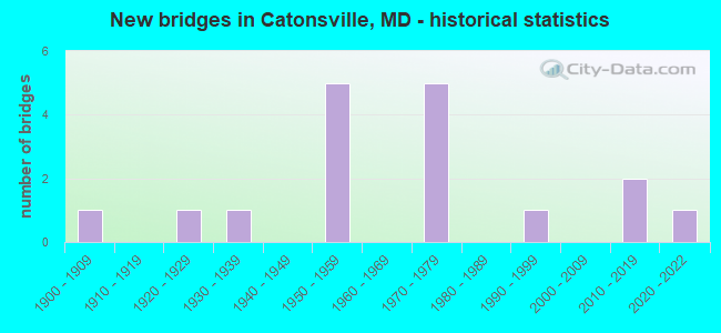
- New bridges - historical statistics
- 11900-1909
- 11920-1929
- 11930-1939
- 51950-1959
- 51970-1979
- 11990-1999
- 22010-2019
- 12020-2022

- Reconstructed bridges - Historical Statistics
- 11960-1969
- 11970-1979
- 11980-1989
- 01990-1999
- 12000-2009


- Bridge Condition - Deck
- 25.0%Good
- 62.5%Satisfactory
- 12.5%Fair

- Bridge Condition - Superstructure
- 11.1%Very good
- 22.2%Good
- 44.4%Satisfactory
- 22.2%Fair

- Bridge Condition - Substructure
- 22.2%Very good
- 11.1%Good
- 33.3%Satisfactory
- 22.2%Fair
- 11.1%Poor

- Bridge Condition - Channel
- 16.7%Very good
- 50.0%Good
- 16.7%Satisfactory
- 16.7%Fair

- Bridge Condition - Culverts
- 50.0%Good
- 50.0%Fair
Find on map >> Show street view
Structure Number: 10000003010901, Location: ON HOWARD CO LINE (Lat: 39.295058, Lng: -76.778836), Route carried "on" structure: US 40, Year Built: 1936, Year Reconstructed: 2011, Status: Open, Structure Length: 10.18m (33.40ft), Average Daily Traffic: 37,530 (year 2009), Truck Traffic: 8%, Average Future Daily Traffic: 45,637 (year 2026), Design Load: H 20, Features Intersected: PATAPSCO RIVER
Minimum Vertical Clearance: 30+ m (98+ ft), Kilometerpoint: 0.000, Lanes on structure: 4, Base Highway Network: Yes, Owner: State Highway Agency, Approaching Roadway Width: 21.9m (71.9ft), Material/Design: Concrete, Design/Construction: Arch - Deck, Number Of Spans In Main Unit: 1, Length of Maximum Span: 54.9m (180.1ft), Curb or Sidewalk Widths: Left: 0.9m (3.0ft), Right: 0.9m (3.0ft), Curb-To-Curb Width: 15.2m (49.9ft), Out-to-Out Width: 18.1m (59.4ft)
Condition: Deck: Good, Superstructure: Good, Substructure: Very good, Channel: Very good, Operating Rating: 63.9 metric tons, Method Used To Determine Operating Rating: Load Factor (LF), Inventory Rating: 38.1 metric tons, Method Used To Determine Inventory Rating: Load Factor (LF), Structural Evaluation: Better than present minimum criteria, Deck Geometry: High priority of corrective action, Waterway Adequacy: Equal to present desirable criteria, Approach Roadway Alignment: Equal to present desirable criteria, Length Of Structure Improvement: 10.18m (33.40ft), Designated Inspection Frequency: Every 24 months, Inspection Date: April 2021, Bridge Improvement Cost: $1,188,000, Roadway Improvement Cost: $119,000, Total Project Cost: $1,307,000, Deck Structure Type: Concrete Cast-file-Place, Wearing Surface/Protective System: Wearing Surface: Monolithic Concrete
Find on map >> Show street view
Structure Number: 10000003012101, Location: 0.05 MI E OF WADE AVENUE (Lat: 0.000108, Lng: -0.000019), Route carried "on" structure: State highway 144, Year Built: 2013, Status: Open, Structure Length: 6.30m (20.67ft), Average Daily Traffic: 19,200 (year 2015), Truck Traffic: 1%, Average Future Daily Traffic: 23,040 (year 2035), Features Intersected: IS 695
Minimum Vertical Clearance: 30+ m (98+ ft), Kilometerpoint: 6.549, Lanes on structure: 6, Lanes under structure: 7, Base Highway Network: Yes, Owner: State Highway Agency, Approaching Roadway Width: 22.9m (75.1ft), Material/Design: Steel continuous, Design/Construction: Stringer/Multi-beam, Number Of Spans In Main Unit: 2, Length of Maximum Span: 32.3m (106.0ft), Curb or Sidewalk Widths: Left: 1.7m (5.6ft), Right: 2.7m (8.9ft), Curb-To-Curb Width: 22.9m (75.1ft), Out-to-Out Width: 28.3m (92.8ft)
Condition: Deck: Good, Superstructure: Good, Substructure: Good, Operating Rating: 64.5 metric tons, Method Used To Determine Operating Rating: Load and Resistance Factor Rating (LRFR) rating reported by rating factor(RF) method using HL-93 loadings, Inventory Rating: 49.6 metric tons, Method Used To Determine Inventory Rating: Load and Resistance Factor Rating (LRFR) rating reported by rating factor(RF) method using HL-93 loadings, Structural Evaluation: Better than present minimum criteria, Deck Geometry: Meets minimum limits, Underclear: High priority of corrective action, Approach Roadway Alignment: Equal to present desirable criteria, Length Of Structure Improvement: 6.31m (20.70ft), Designated Inspection Frequency: Every 24 months, Inspection Date: September 2020, Deck Structure Type: Concrete Cast-file-Place, Wearing Surface/Protective System: Wearing Surface: Monolithic Concrete, Deck Protection: Epoxy Coated Reinforcing
Find on map >> Show street view
Structure Number: 10000003012401, Location: 1.23 MILE NORTH OF MD 144 (Lat: 39.286056, Lng: -76.738200), Route carried "on" structure: Interstate 695, Year Built: 1958, Year Reconstructed: 1978, Status: Open, Structure Length: 7.38m (24.21ft), Average Daily Traffic: 188,860 (year 2009), Truck Traffic: 8%, Average Future Daily Traffic: 203,606 (year 2029), Design Load: HS 20, Features Intersected: US 40
Minimum Vertical Clearance: 30+ m (98+ ft), Kilometerpoint: 9.316, Lanes on structure: 9, Lanes under structure: 8, Base Highway Network: Yes, Owner: State Highway Agency, Approaching Roadway Width: 38.4m (126.0ft), Skew: 22 degrees, Material/Design: Steel, Design/Construction: Stringer/Multi-beam, Number Of Spans In Main Unit: 4, Length of Maximum Span: 25.0m (82.0ft), Curb-To-Curb Width: 39.0m (128.0ft), Out-to-Out Width: 39.9m (130.9ft)
Condition: Deck: Satisfactory, Superstructure: Fair, Substructure: Poor, Operating Rating: 76.2 metric tons, Method Used To Determine Operating Rating: Load Factor (LF), Inventory Rating: 45.4 metric tons, Method Used To Determine Inventory Rating: Load Factor (LF), Structural Evaluation: Meets minimum limits, Deck Geometry: Equal to present minimum criteria, Underclear: Equal to present minimum criteria, Approach Roadway Alignment: Equal to present desirable criteria, Length Of Structure Improvement: 7.38m (24.21ft), Designated Inspection Frequency: Every 24 months, Inspection Date: November 2021, Bridge Improvement Cost: $3,804,000, Roadway Improvement Cost: $380,000, Total Project Cost: $4,184,000, Deck Structure Type: Concrete Cast-file-Place, Wearing Surface/Protective System: Wearing Surface: Bituminous
Find on map >> Show street view
Structure Number: 100000030291011, Location: 0.38 MILE NORTH OF IS 195 (Lat: 39.245369, Lng: -76.715656), Route carried "on" structure: State highway 166, Year Built: 1975, Status: Open, Structure Length: 8.17m (26.80ft), Average Daily Traffic: 11,636 (year 2012), Truck Traffic: 8%, Average Future Daily Traffic: 13,964 (year 2032), Design Load: HS 20, Features Intersected: RAMP 5 FROM UMBC
Minimum Vertical Clearance: 30+ m (98+ ft), Kilometerpoint: 0.571, Lanes on structure: 3, Lanes under structure: 2, Base Highway Network: Yes, Owner: State Highway Agency, Approaching Roadway Width: 12.2m (40.0ft), Skew: 4 degrees, Material/Design: Steel continuous, Design/Construction: Stringer/Multi-beam, Number Of Spans In Main Unit: 3, Length of Maximum Span: 28.0m (91.9ft), Curb-To-Curb Width: 15.7m (51.5ft), Out-to-Out Width: 16.7m (54.8ft)
Condition: Deck: Satisfactory, Superstructure: Satisfactory, Substructure: Satisfactory, Operating Rating: 60.3 metric tons, Method Used To Determine Operating Rating: Load Factor (LF), Inventory Rating: 36.3 metric tons, Method Used To Determine Inventory Rating: Load Factor (LF), Structural Evaluation: Equal to present minimum criteria, Deck Geometry: Somewhat better than minimum adequacy, Underclear: Equal to present minimum criteria, Approach Roadway Alignment: Equal to present desirable criteria, Designated Inspection Frequency: Every 24 months, Inspection Date: April 2021, Deck Structure Type: Concrete Cast-file-Place, Wearing Surface/Protective System: Wearing Surface: Monolithic Concrete
Find on map >> Show street view
Structure Number: 100000030291012, Location: 0.38 MILE NORTH OF IS 195 (Lat: 39.245517, Lng: -76.716406), Route carried "on" structure: State highway 166, Year Built: 1975, Status: Open, Structure Length: 8.17m (26.80ft), Average Daily Traffic: 9,143 (year 2012), Truck Traffic: 8%, Average Future Daily Traffic: 10,971 (year 2032), Design Load: HS 20, Features Intersected: RAMP 5'X' FROM UMBC
Minimum Vertical Clearance: 30+ m (98+ ft), Kilometerpoint: 0.571, Lanes on structure: 2, Lanes under structure: 1, Base Highway Network: Yes, Owner: State Highway Agency, Approaching Roadway Width: 12.2m (40.0ft), Skew: 4 degrees, Material/Design: Steel continuous, Design/Construction: Stringer/Multi-beam, Number Of Spans In Main Unit: 3, Length of Maximum Span: 28.0m (91.9ft), Curb-To-Curb Width: 16.6m (54.5ft), Out-to-Out Width: 17.6m (57.7ft)
Condition: Deck: Satisfactory, Superstructure: Satisfactory, Substructure: Satisfactory, Operating Rating: 58.5 metric tons, Method Used To Determine Operating Rating: Load Factor (LF), Inventory Rating: 34.9 metric tons, Method Used To Determine Inventory Rating: Load Factor (LF), Structural Evaluation: Equal to present minimum criteria, Deck Geometry: Superior to present desirable criteria, Underclear: Equal to present minimum criteria, Approach Roadway Alignment: Equal to present desirable criteria, Designated Inspection Frequency: Every 24 months, Inspection Date: April 2021, Deck Structure Type: Concrete Cast-file-Place, Wearing Surface/Protective System: Wearing Surface: Monolithic Concrete
Find on map >> Show street view
Structure Number: 200000B-005501, Location: 0.2 MI N FREDERICK RD (Lat: 39.268194, Lng: -76.791222), Route carried "on" structure: County highway 2929, Year Built: 1900, Year Reconstructed: 1968, Status: Open, Structure Length: 3.11m (10.20ft), Average Daily Traffic: 1,730 (year 2018), Truck Traffic: 5%, Average Future Daily Traffic: 4,590 (year 2038), Design Load: HS 20, Features Intersected: RAVINE WITH BICYCLE TRAI, Facility Carried by Structure: WESTCHESTER AVENUE
Minimum Vertical Clearance: 30+ m (98+ ft), Kilometerpoint: 0.306, Lanes on structure: 1, Owner: County Highway Agency, Approaching Roadway Width: 4.3m (14.1ft), Material/Design: Steel, Design/Construction: Truss - Thru, Number Of Spans In Main Unit: 1, Length of Maximum Span: 30.5m (100.1ft), Curb-To-Curb Width: 4.1m (13.5ft), Out-to-Out Width: 5.0m (16.4ft)
Condition: Deck: Fair, Superstructure: Satisfactory, Substructure: Fair, Operating Rating: 39.5 metric tons, Method Used To Determine Operating Rating: Load Factor (LF), Inventory Rating: 23.6 metric tons, Method Used To Determine Inventory Rating: Load Factor (LF), Structural Evaluation: Somewhat better than minimum adequacy, Deck Geometry: High priority of replacement, Approach Roadway Alignment: Equal to present minimum criteria, Designated Inspection Frequency: Every 24 months, Critical Feature Inspection Frequency: Every 24 months, Inspection Date: January 2020, Critical Feature Inspection Date: January 2020, Deck Structure Type: Steel plate, Wearing Surface/Protective System: Wearing Surface: Other
Find on map >> Show street view
Structure Number: 200000B-005601, Location: 1.58 MI S OF MD RTE 144 (Lat: 39.251272, Lng: -76.763756), Route carried "on" structure: County highway 2934, Year Built: 1955, Year Reconstructed: 1980, Status: Open, Structure Length: 5.67m (18.60ft), Average Daily Traffic: 2,000 (year 2021), Truck Traffic: 5%, Average Future Daily Traffic: 3,350 (year 2041), Design Load: HS 20, Features Intersected: PATAPSCO RIVER, Facility Carried by Structure: ILCHESTER ROAD
Minimum Vertical Clearance: 30+ m (98+ ft), Kilometerpoint: 2.542, Lanes on structure: 2, Owner: County Highway Agency, Approaching Roadway Width: 7.9m (25.9ft), Skew: 2 degrees, Material/Design: Steel, Design/Construction: Stringer/Multi-beam, Number Of Spans In Main Unit: 2, Length of Maximum Span: 27.4m (89.9ft), Curb or Sidewalk Widths: Left: 0.0m, Right: 0.9m (3.0ft), Curb-To-Curb Width: 8.7m (28.5ft), Out-to-Out Width: 10.4m (34.1ft)
Condition: Deck: Satisfactory, Superstructure: Satisfactory, Substructure: Fair, Channel: Good, Operating Rating: 67.1 metric tons, Method Used To Determine Operating Rating: Load Factor (LF), Inventory Rating: 39.9 metric tons, Method Used To Determine Inventory Rating: Load Factor (LF), Structural Evaluation: Somewhat better than minimum adequacy, Deck Geometry: Somewhat better than minimum adequacy, Waterway Adequacy: Equal to present desirable criteria, Approach Roadway Alignment: High priority of corrective action, Designated Inspection Frequency: Every 24 months, Underwater Inspection Frequency: Every 48 months, Inspection Date: November 2021, Underwater Inspection Date: November 2019, Deck Structure Type: Concrete Cast-file-Place, Wearing Surface/Protective System: Wearing Surface: Monolithic Concrete
Find on map >> Show street view
Structure Number: 200000B-017701, Location: 0.57 MI S OF MD 144 (Lat: 39.257667, Lng: -76.765111), Route carried "on" structure: County highway 2936, Year Built: 1920, Status: Posted for load, Structure Length: 1.39m (4.56ft), Average Daily Traffic: 2,400 (year 2013), Truck Traffic: 5%, Average Future Daily Traffic: 4,400 (year 2035), Features Intersected: TRIB. TO PATAPSCO RIVER, Facility Carried by Structure: THISTLE ROAD
Minimum Vertical Clearance: 30+ m (98+ ft), Kilometerpoint: 0.917, Lanes on structure: 2, Owner: County Highway Agency, Approaching Roadway Width: 6.7m (22.0ft), Skew: 3 degrees, Material/Design: Concrete continuous, Design/Construction: Tee Beam, Number Of Spans In Main Unit: 2, Length of Maximum Span: 7.3m (24.0ft), Curb-To-Curb Width: 8.6m (28.2ft), Out-to-Out Width: 9.1m (29.9ft)
Condition: Deck: Satisfactory, Superstructure: Fair, Substructure: Satisfactory, Channel: Satisfactory, Operating Rating: 13.6 metric tons, Method Used To Determine Operating Rating: Field evaluation and documented engineering judgment, Inventory Rating: 13.6 metric tons, Method Used To Determine Inventory Rating: Field evaluation and documented engineering judgment, Structural Evaluation: Meets minimum limits, Deck Geometry: Meets minimum limits, Waterway Adequacy: Equal to present minimum criteria, Approach Roadway Alignment: Equal to present minimum criteria, Bridge Posting: Required (Relationship of Operating Rating to Maximum Legal Load: > 39.9% below), Designated Inspection Frequency: Every 12 months, Inspection Date: June 2021, Deck Structure Type: Concrete Cast-file-Place, Wearing Surface/Protective System: Wearing Surface: Bituminous
Find on map >> Show street view
Structure Number: 200000B-018401, Location: 1.24 MILES S OF MD 144 (Lat: 39.253306, Lng: -76.768917), Route carried "on" structure: County highway 2934, Year Built: 2020, Status: Open, Structure Length: 1.17m (3.84ft), Average Daily Traffic: 956 (year 2019), Truck Traffic: 5%, Average Future Daily Traffic: 1,168 (year 2039), Features Intersected: TRIB OF PATAPSCO RIVER, Facility Carried by Structure: RIVER ROAD
Minimum Vertical Clearance: 30+ m (98+ ft), Kilometerpoint: 1.995, Lanes on structure: 2, Owner: County Highway Agency, Approaching Roadway Width: 6.7m (22.0ft), Material/Design: Concrete, Design/Construction: Arch - Deck, Number Of Spans In Main Unit: 1, Length of Maximum Span: 11.3m (37.1ft), Curb-To-Curb Width: 6.7m (22.0ft), Out-to-Out Width: 7.9m (25.9ft)
Condition: Superstructure: Very good, Substructure: Very good, Channel: Good, Operating Rating: 55.1 metric tons, Method Used To Determine Operating Rating: Load and Resistance Factor Rating (LRFR) rating reported by rating factor(RF) method using HL-93 loadings, Inventory Rating: 38.9 metric tons, Method Used To Determine Inventory Rating: Load and Resistance Factor Rating (LRFR) rating reported by rating factor(RF) method using HL-93 loadings, Structural Evaluation: Equal to present desirable criteria, Deck Geometry: Meets minimum limits, Waterway Adequacy: Superior to present desirable criteria, Approach Roadway Alignment: Equal to present minimum criteria, Designated Inspection Frequency: Every 24 months, Inspection Date: October 2020
Find on map >> Show street view
Structure Number: 200000B-040502, Location: 200' S. OF EDMONDSON AVE. (Lat: 39.272653, Lng: -76.753217), Route carried "on" structure: County highway 2879, Year Built: 1979, Status: Posted for load, Structure Length: 0.88m (2.89ft), Average Daily Traffic: 6,522 (year 2018), Truck Traffic: 4%, Average Future Daily Traffic: 9,895 (year 2040), Design Load: HS 20, Features Intersected: TRIB TO PATAPSCO RIVER, Facility Carried by Structure: DUTTON AVE, EDMOND
Minimum Vertical Clearance: 30+ m (98+ ft), Kilometerpoint: 0.032, Lanes on structure: 2, Owner: County Highway Agency, Approaching Roadway Width: 9.8m (32.2ft), Skew: 5 degrees, Material/Design: Concrete, Design/Construction: Culvert, Length of Maximum Span: 3.0m (9.8ft), Curb or Sidewalk Widths: Left: 1.5m (4.9ft), Right: 1.5m (4.9ft)
Condition: Channel: Good, Culverts: Fair, Operating Rating: 42.6 metric tons, Method Used To Determine Operating Rating: Load Factor (LF), Inventory Rating: 25.4 metric tons, Method Used To Determine Inventory Rating: Load Factor (LF), Structural Evaluation: Somewhat better than minimum adequacy, Waterway Adequacy: Better than present minimum criteria, Approach Roadway Alignment: Equal to present desirable criteria, Designated Inspection Frequency: Every 24 months, Inspection Date: January 2020
Find on map >> Show street view
Structure Number: 200000B-044003, Location: 0.1 MI W OF ROLLING ROAD (Lat: 39.250494, Lng: -76.728678), Route carried "on" structure: County highway 7569, Year Built: 1991, Status: Open, Structure Length: 1.00m (3.28ft), Average Daily Traffic: 1,000 (year 2019), Truck Traffic: 5%, Average Future Daily Traffic: 1,500 (year 2039), Design Load: HS 20, Features Intersected: BULL BRANCH, Facility Carried by Structure: COLLEGIATE DRIVE
Minimum Vertical Clearance: 30+ m (98+ ft), Kilometerpoint: 0.000, Lanes on structure: 2, Owner: County Highway Agency, Approaching Roadway Width: 12.2m (40.0ft), Skew: 1 degrees, Material/Design: Steel, Design/Construction: Culvert, Length of Maximum Span: 4.3m (14.1ft), Curb or Sidewalk Widths: Left: 1.2m (3.9ft), Right: 0.0m
Condition: Channel: Fair, Culverts: Good, Structural Evaluation: Better than present minimum criteria, Waterway Adequacy: Better than present minimum criteria, Approach Roadway Alignment: Equal to present desirable criteria, Designated Inspection Frequency: Every 24 months, Inspection Date: July 2021
Find on map >> Show street view
Structure Number: 10000003012101, Location: 1.24 MILE NORTH OF MD 372 (Lat: 39.273494, Lng: -76.724694), Route carried "under" structure: Interstate 695, Year Built: 2013, Structure Length: 0. m, Average Daily Traffic: 193,762 (year 2012), Truck Traffic: 12%, Features Intersected: IS 695, Facility Carried by Structure: MD 144
Minimum Vertical Clearance: 5.18m (16.99ft), Kilometerpoint: 7.337, Lanes on structure: 6, Lanes under structure: 7, Material/Design: Steel continuous, Design/Construction: Stringer/Multi-beam, Length of Maximum Span: 19.8m (65.0ft)
Find on map >> Show street view
Structure Number: 100000030122016, Location: 0.48 MI N OF MD 144 (Lat: 39.279817, Lng: -76.727228), Route carried "under" structure: County highway 2600, Year Built: 1957, Structure Length: 0. m, Average Daily Traffic: 7,767 (year 2007), Features Intersected: EDMONDSON AVENUE, Facility Carried by Structure: IS 695 OL
Minimum Vertical Clearance: 4.88m (16.01ft), Kilometerpoint: 4.135, Lanes on structure: 8, Lanes under structure: 4, Material/Design: Steel, Design/Construction: Stringer/Multi-beam, Length of Maximum Span: 20.4m (66.9ft)
Find on map >> Show street view
Structure Number: 10000003012301, Location: 0.48 MI S OF US 40 (Lat: 39.281989, Lng: -76.731089), Route carried "under" structure: County highway 2621, Year Built: 1957, Structure Length: 0. m, Average Daily Traffic: 7,638 (year 2007), Features Intersected: INGLESIDE AVENUE, Facility Carried by Structure: IS 695
Minimum Vertical Clearance: 3.96m (12.99ft), Kilometerpoint: 1.175, Lanes on structure: 9, Lanes under structure: 2, Material/Design: Steel, Design/Construction: Stringer/Multi-beam, Length of Maximum Span: 14.9m (48.9ft)
Find on map >> Show street view
Structure Number: 10000003012401, Location: 1.23 MI N OF MD 144 (Lat: 39.286056, Lng: -76.738200), Route carried "under" structure: US 40, Year Built: 1958, Structure Length: 0. m, Average Daily Traffic: 51,160 (year 2009), Features Intersected: US 40(BALTO NAT'L PIKE), Facility Carried by Structure: IS 695
Minimum Vertical Clearance: 4.88m (16.01ft), Kilometerpoint: 3.926, Lanes on structure: 9, Lanes under structure: 8, Material/Design: Steel, Design/Construction: Stringer/Multi-beam, Length of Maximum Span: 25.0m (82.0ft)
Find on map >> Show street view
Structure Number: 100000030291011, Location: 0.38 MI N OF IS 195 (Lat: 39.245369, Lng: -76.715656), Route carried "under" structure: State lands road 166, Year Built: 1975, Structure Length: 0. m, Average Daily Traffic: 5,422 (year 2012), Features Intersected: RAMP 5'X' FROM UMBC
Minimum Vertical Clearance: 6.10m (20.01ft), Kilometerpoint: 0.182, Lanes on structure: 2, Lanes under structure: 1, Material/Design: Steel continuous, Design/Construction: Stringer/Multi-beam, Length of Maximum Span: 28.0m (91.9ft)
Find on map >> Show street view
Structure Number: 100000030291012, Location: 0.38 MI N OF IS 195 (Lat: 39.245517, Lng: -76.716406), Route carried "under" structure: State lands road 166, Year Built: 1975, Structure Length: 0. m, Average Daily Traffic: 5,422 (year 2012), Features Intersected: RAMP 5'X' FROM UMBC
Minimum Vertical Clearance: 6.10m (20.01ft), Kilometerpoint: 0.212, Lanes on structure: 2, Lanes under structure: 1, Material/Design: Steel continuous, Design/Construction: Stringer/Multi-beam, Length of Maximum Span: 28.0m (91.9ft)