Bridge Statistics for Carnot-Moon, Pennsylvania (PA)
Condition, Traffic, Stress, Structural Evaluation, Project Costs
- National Bridge Inventory (NBI) Statistics
- 42Number of bridges
- 466ft / 142mTotal length
- $1,816,000Total costs
- 360,831Total average daily traffic
- 38,398Total average daily truck traffic
- National Bridge Inventory (NBI) Registered Bridges for Carnot-Moon
- No street view available for this location
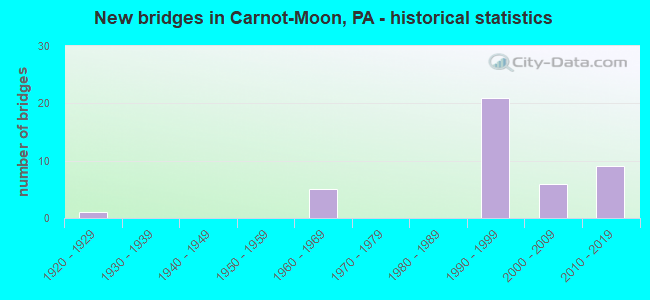
- New bridges - historical statistics
- 11920-1929
- 51960-1969
- 211990-1999
- 62000-2009
- 92010-2019
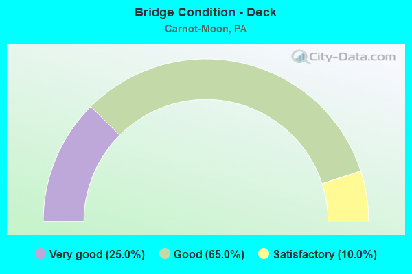
- Bridge Condition - Deck
- 25.0%Very good
- 65.0%Good
- 10.0%Satisfactory
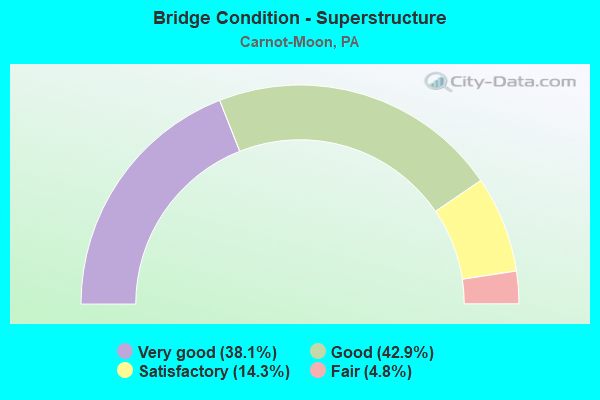
- Bridge Condition - Superstructure
- 38.1%Very good
- 42.9%Good
- 14.3%Satisfactory
- 4.8%Fair
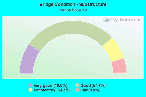
- Bridge Condition - Substructure
- 19.0%Very good
- 57.1%Good
- 14.3%Satisfactory
- 9.5%Fair
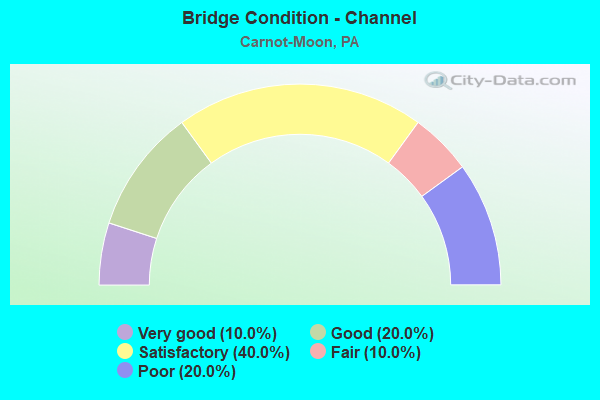
- Bridge Condition - Channel
- 10.0%Very good
- 20.0%Good
- 40.0%Satisfactory
- 10.0%Fair
- 20.0%Poor
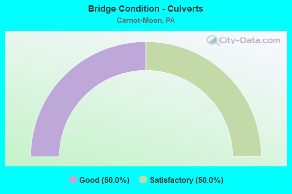
- Bridge Condition - Culverts
- 50.0%Good
- 50.0%Satisfactory
Find on map >> Show street view
Structure Number: 761, Location: @ YAMAHA / SUZUKI (Lat: 40.537194, Lng: -80.196211), Route carried "on" structure: State highway 51, Year Built: 1962, Status: Open, Structure Length: 0.64m (2.10ft), Average Daily Traffic: 23,170 (year 2022), Truck Traffic: 9%, Average Future Daily Traffic: 26,507 (year 2032), Design Load: HS 20, Features Intersected: NARROWS RUN, Facility Carried by Structure: STOOPS FERRY RD
Minimum Vertical Clearance: 30+ m (98+ ft), Kilometerpoint: 52.996, Lanes on structure: 4, Base Highway Network: Yes, Owner: State Highway Agency, Approaching Roadway Width: 21.9m (71.9ft), Skew: 35 degrees, Material/Design: Concrete, Design/Construction: Culvert, Number Of Spans In Main Unit: 1, Length of Maximum Span: 6.4m (21.0ft)
Condition: Channel: Satisfactory, Culverts: Satisfactory, Operating Rating: 49.0 metric tons, Method Used To Determine Operating Rating: Field evaluation and documented engineering judgment, Inventory Rating: 32.7 metric tons, Method Used To Determine Inventory Rating: Field evaluation and documented engineering judgment, Structural Evaluation: Equal to present minimum criteria, Waterway Adequacy: Equal to present minimum criteria, Approach Roadway Alignment: Equal to present desirable criteria, Length Of Structure Improvement: 0.60m (1.97ft), Designated Inspection Frequency: Every 24 months, Inspection Date: December 2019
Find on map >> Show street view
Structure Number: 1853, Location: 1/4 MI. E. OF TWP. RD.114 (Lat: 40.529300, Lng: -80.237625), Route carried "on" structure: State highway , Year Built: 1925, Status: Open, Structure Length: 1.83m (6.00ft), Average Daily Traffic: 5,309 (year 2022), Truck Traffic: 6%, Average Future Daily Traffic: 7,227 (year 2032), Design Load: HS 20, Features Intersected: FLAUGHERTY RUN, Facility Carried by Structure: FLAUGHERTY RUN RD
Minimum Vertical Clearance: 30+ m (98+ ft), Kilometerpoint: 11.055, Lanes on structure: 2, Owner: State Highway Agency, Approaching Roadway Width: 6.1m (20.0ft), Skew: 3 degrees, Material/Design: Concrete, Design/Construction: Arch - Deck, Number Of Spans In Main Unit: 1, Length of Maximum Span: 9.1m (29.9ft), Curb-To-Curb Width: 6.5m (21.3ft), Out-to-Out Width: 8.5m (27.9ft)
Condition: Superstructure: Fair, Substructure: Fair, Channel: Poor, Operating Rating: 49.0 metric tons, Method Used To Determine Operating Rating: Field evaluation and documented engineering judgment, Inventory Rating: 32.7 metric tons, Method Used To Determine Inventory Rating: Field evaluation and documented engineering judgment, Structural Evaluation: Somewhat better than minimum adequacy, Deck Geometry: High priority of replacement, Waterway Adequacy: Equal to present minimum criteria, Approach Roadway Alignment: Equal to present desirable criteria, Length Of Structure Improvement: 1.80m (5.91ft), Designated Inspection Frequency: Every 24 months, Inspection Date: November 2019, Bridge Improvement Cost: $22,000, Roadway Improvement Cost: $65,000, Total Project Cost: $297,000
Find on map >> Show street view
Structure Number: 1896, Location: 1/4 MI E OF AIRSIDE BUS P (Lat: 40.485000, Lng: -80.203333), Route carried "on" structure: State highway , Year Built: 1991, Status: Open, Structure Length: 4.82m (15.81ft), Average Daily Traffic: 8,360 (year 2022), Truck Traffic: 8%, Average Future Daily Traffic: 2,911 (year 2032), Design Load: HS 20, Features Intersected: SR 3160 - BUSINESS 376, Facility Carried by Structure: CORAOPOLIS HTS RD
Minimum Vertical Clearance: 30+ m (98+ ft), Kilometerpoint: 0.000, Lanes on structure: 4, Lanes under structure: 10, Owner: State Highway Agency, Approaching Roadway Width: 19.2m (63.0ft), Material/Design: Steel, Design/Construction: Stringer/Multi-beam, Number Of Spans In Main Unit: 1, Length of Maximum Span: 46.3m (151.9ft), Curb or Sidewalk Widths: Left: 1.5m (4.9ft), Right: 0.2m (0.7ft), Curb-To-Curb Width: 19.4m (63.6ft), Out-to-Out Width: 21.5m (70.5ft)
Condition: Deck: Good, Superstructure: Good, Substructure: Good, Inventory Rating: 67.1 metric tons, Method Used To Determine Inventory Rating: Load Factor (LF), Structural Evaluation: Better than present minimum criteria, Deck Geometry: Better than present minimum criteria, Underclear: Meets minimum limits, Approach Roadway Alignment: Equal to present desirable criteria, Length Of Structure Improvement: 4.80m (15.75ft), Designated Inspection Frequency: Every 24 months, Inspection Date: October 2019, Deck Structure Type: Concrete Cast-file-Place, Wearing Surface/Protective System: Wearing Surface: Monolithic Concrete, Deck Protection: Epoxy Coated Reinforcing
Find on map >> Show street view
Structure Number: 1899, Location: EXIT TO SR 376 BUSINESS (Lat: 40.522933, Lng: -80.273131), Route carried "on" structure: Interstate 376B, Year Built: 1991, Status: Open, Structure Length: 16.82m (55.18ft), Average Daily Traffic: 4,973 (year 2022), Truck Traffic: 2%, Average Future Daily Traffic: 6,869 (year 2032), Design Load: HS 20, Features Intersected: INTERSTATE 376, Facility Carried by Structure: RAMP FR-E
Minimum Vertical Clearance: 30+ m (98+ ft), Kilometerpoint: 0.000, Lanes on structure: 2, Lanes under structure: 4, Base Highway Network: Yes, Owner: State Highway Agency, Approaching Roadway Width: 12.2m (40.0ft), Material/Design: Steel continuous, Design/Construction: Stringer/Multi-beam, Number Of Spans In Main Unit: 2, Number Of Approach Spans: 1, Length of Maximum Span: 76.8m (252.0ft), Curb or Sidewalk Widths: Left: 0.2m (0.7ft), Right: 0.2m (0.7ft), Curb-To-Curb Width: 12.2m (40.0ft), Out-to-Out Width: 13.3m (43.6ft)
Condition: Deck: Satisfactory, Superstructure: Good, Substructure: Satisfactory, Operating Rating: 73.5 metric tons, Method Used To Determine Operating Rating: Load Factor (LF), Inventory Rating: 43.5 metric tons, Method Used To Determine Inventory Rating: Load Factor (LF), Structural Evaluation: Equal to present minimum criteria, Deck Geometry: Better than present minimum criteria, Underclear: Superior to present desirable criteria, Approach Roadway Alignment: Equal to present desirable criteria, Length Of Structure Improvement: 16.80m (55.12ft), Designated Inspection Frequency: Every 24 months, Inspection Date: October 2019, Deck Structure Type: Concrete Cast-file-Place, Wearing Surface/Protective System: Wearing Surface: Monolithic Concrete, Deck Protection: Epoxy Coated Reinforcing
Find on map >> Show street view
Structure Number: 226, Location: OPA107 APO1 AIRPORT 5-1 (Lat: 40.496697, Lng: -80.256697), Route carried "on" structure: Ramp Other road , Year Built: 1992, Status: Open, Structure Length: 41.64m (136.61ft), Average Daily Traffic: 4,601 (year 2002), Truck Traffic: 6%, Average Future Daily Traffic: 4,601 (year 2019), Design Load: HS 25 or greater, Features Intersected: RAMP DP-E, BAGGAGE BRDGS, Facility Carried by Structure: RAMP EP-E RD
Minimum Vertical Clearance: 30+ m (98+ ft), Kilometerpoint: 0.000, Lanes on structure: 2, Lanes under structure: 12, Owner: Local Agency, Approaching Roadway Width: 8.5m (27.9ft), Material/Design: Steel continuous, Design/Construction: Stringer/Multi-beam, Number Of Spans In Main Unit: 9, Number Of Approach Spans: 6, Length of Maximum Span: 42.7m (140.1ft), Curb or Sidewalk Widths: Left: 0.2m (0.7ft), Right: 1.5m (4.9ft), Curb-To-Curb Width: 8.6m (28.2ft), Out-to-Out Width: 11.4m (37.4ft)
Condition: Deck: Good, Superstructure: Good, Substructure: Good, Operating Rating: 64.4 metric tons, Method Used To Determine Operating Rating: Load Factor (LF), Inventory Rating: 38.1 metric tons, Method Used To Determine Inventory Rating: Load Factor (LF), Structural Evaluation: Better than present minimum criteria, Deck Geometry: Meets minimum limits, Underclear: High priority of corrective action, Approach Roadway Alignment: Equal to present desirable criteria, Length Of Structure Improvement: 41.60m (136.48ft), Designated Inspection Frequency: Every 24 months, Critical Feature Inspection Frequency: Every 24 months, Inspection Date: June 2021, Critical Feature Inspection Date: June 2021, Deck Structure Type: Concrete Cast-file-Place, Wearing Surface/Protective System: Wearing Surface: Latex Concrete, Deck Protection: Epoxy Coated Reinforcing
Find on map >> Show street view
Structure Number: 2265, Location: OPA110 AP06 AIRPORT 10-2 (Lat: 40.493297, Lng: -80.256697), Route carried "on" structure: Ramp Other road , Year Built: 1992, Status: Open, Structure Length: 2.99m (9.81ft), Average Daily Traffic: 5,566 (year 2002), Truck Traffic: 6%, Average Future Daily Traffic: 5,566 (year 2019), Design Load: HS 25 or greater, Features Intersected: RAMP EP-E(SOUTH), Facility Carried by Structure: RAMP EP-W RD
Minimum Vertical Clearance: 30+ m (98+ ft), Kilometerpoint: 0.000, Lanes on structure: 2, Lanes under structure: 2, Base Highway Network: Yes, Owner: Local Agency, Approaching Roadway Width: 14.3m (46.9ft), Skew: 3 degrees, Material/Design: Steel, Design/Construction: Stringer/Multi-beam, Number Of Spans In Main Unit: 1, Length of Maximum Span: 28.3m (92.8ft), Curb or Sidewalk Widths: Left: 0.2m (0.7ft), Right: 0.2m (0.7ft), Curb-To-Curb Width: 12.7m (41.7ft), Out-to-Out Width: 13.6m (44.6ft)
Condition: Deck: Good, Superstructure: Good, Substructure: Good, Operating Rating: 75.3 metric tons, Method Used To Determine Operating Rating: Load Factor (LF), Inventory Rating: 45.4 metric tons, Method Used To Determine Inventory Rating: Load Factor (LF), Structural Evaluation: Better than present minimum criteria, Deck Geometry: Superior to present desirable criteria, Underclear: Equal to present minimum criteria, Approach Roadway Alignment: Equal to present desirable criteria, Length Of Structure Improvement: 3.00m (9.84ft), Designated Inspection Frequency: Every 24 months, Inspection Date: June 2021, Deck Structure Type: Concrete Cast-file-Place, Wearing Surface/Protective System: Wearing Surface: Latex Concrete, Deck Protection: Epoxy Coated Reinforcing
Find on map >> Show street view
Structure Number: 2266, Location: OPA111 AIRPORT 10-4 AP07 (Lat: 40.493297, Lng: -80.258300), Route carried "on" structure: Ramp Other road , Year Built: 1992, Status: Open, Structure Length: 3.05m (10.01ft), Average Daily Traffic: 4,344 (year 2002), Truck Traffic: 6%, Average Future Daily Traffic: 5,566 (year 2017), Design Load: HS 25 or greater, Features Intersected: RAMP EP-E, Facility Carried by Structure: RAMP CM RD
Minimum Vertical Clearance: 30+ m (98+ ft), Kilometerpoint: 0.000, Lanes on structure: 1, Lanes under structure: 1, Owner: Local Agency, Approaching Roadway Width: 6.7m (22.0ft), Skew: 3 degrees, Material/Design: Steel, Design/Construction: Stringer/Multi-beam, Number Of Spans In Main Unit: 1, Length of Maximum Span: 28.3m (92.8ft), Curb or Sidewalk Widths: Left: 0.2m (0.7ft), Right: 0.2m (0.7ft), Curb-To-Curb Width: 6.7m (22.0ft), Out-to-Out Width: 7.5m (24.6ft)
Condition: Deck: Satisfactory, Superstructure: Satisfactory, Substructure: Good, Operating Rating: 74.4 metric tons, Method Used To Determine Operating Rating: Load Factor (LF), Inventory Rating: 44.5 metric tons, Method Used To Determine Inventory Rating: Load Factor (LF), Structural Evaluation: Equal to present minimum criteria, Deck Geometry: Equal to present minimum criteria, Underclear: Equal to present minimum criteria, Approach Roadway Alignment: Better than present minimum criteria, Length Of Structure Improvement: 3.00m (9.84ft), Designated Inspection Frequency: Every 24 months, Critical Feature Inspection Frequency: Every 24 months, Inspection Date: June 2021, Critical Feature Inspection Date: June 2021, Deck Structure Type: Concrete Cast-file-Place, Wearing Surface/Protective System: Wearing Surface: Latex Concrete, Deck Protection: Epoxy Coated Reinforcing
Find on map >> Show street view
Structure Number: 2267, Location: OPA112 AP08 AIRPORT 10-5 (Lat: 40.493297, Lng: -80.258300), Route carried "on" structure: Business Other road , Year Built: 1992, Status: Open, Structure Length: 2.96m (9.71ft), Average Daily Traffic: 2,867 (year 2002), Truck Traffic: 6%, Average Future Daily Traffic: 2,867 (year 2019), Design Load: HS 25 or greater, Features Intersected: RAMP EP-E, Facility Carried by Structure: RENTAL ACCESS RD
Minimum Vertical Clearance: 30+ m (98+ ft), Kilometerpoint: 0.000, Lanes on structure: 2, Lanes under structure: 1, Owner: Local Agency, Approaching Roadway Width: 11.6m (38.1ft), Skew: 3 degrees, Material/Design: Steel, Design/Construction: Stringer/Multi-beam, Number Of Spans In Main Unit: 1, Length of Maximum Span: 27.4m (89.9ft), Curb or Sidewalk Widths: Left: 0.2m (0.7ft), Right: 0.2m (0.7ft), Curb-To-Curb Width: 11.6m (38.1ft), Out-to-Out Width: 12.3m (40.4ft)
Condition: Deck: Good, Superstructure: Satisfactory, Substructure: Satisfactory, Operating Rating: 70.8 metric tons, Method Used To Determine Operating Rating: Load Factor (LF), Inventory Rating: 41.7 metric tons, Method Used To Determine Inventory Rating: Load Factor (LF), Structural Evaluation: Equal to present minimum criteria, Deck Geometry: Somewhat better than minimum adequacy, Underclear: Equal to present minimum criteria, Approach Roadway Alignment: Equal to present minimum criteria, Length Of Structure Improvement: 3.70m (12.14ft), Designated Inspection Frequency: Every 24 months, Inspection Date: June 2021, Deck Structure Type: Concrete Cast-file-Place, Wearing Surface/Protective System: Wearing Surface: Latex Concrete, Deck Protection: Epoxy Coated Reinforcing
Find on map >> Show street view
Structure Number: 2268, Location: OPA113 AP09 AIRPORT 10-6 (Lat: 40.491700, Lng: -80.256697), Route carried "on" structure: Ramp Other road , Year Built: 1992, Status: Open, Structure Length: 2.19m (7.19ft), Average Daily Traffic: 5,566 (year 2002), Truck Traffic: 6%, Average Future Daily Traffic: 5,566 (year 2019), Design Load: HS 25 or greater, Features Intersected: RENTAL CAR ACCESS ROAD, Facility Carried by Structure: RAMP EP-W RD
Minimum Vertical Clearance: 30+ m (98+ ft), Kilometerpoint: 0.000, Lanes on structure: 2, Lanes under structure: 2, Base Highway Network: Yes, Owner: Local Agency, Approaching Roadway Width: 8.8m (28.9ft), Material/Design: Steel, Design/Construction: Stringer/Multi-beam, Number Of Spans In Main Unit: 1, Length of Maximum Span: 21.3m (69.9ft), Curb or Sidewalk Widths: Left: 0.2m (0.7ft), Right: 0.2m (0.7ft), Curb-To-Curb Width: 8.5m (27.9ft), Out-to-Out Width: 9.3m (30.5ft)
Condition: Deck: Good, Superstructure: Satisfactory, Substructure: Good, Operating Rating: 69.9 metric tons, Method Used To Determine Operating Rating: Load Factor (LF), Inventory Rating: 41.7 metric tons, Method Used To Determine Inventory Rating: Load Factor (LF), Structural Evaluation: Equal to present minimum criteria, Deck Geometry: High priority of corrective action, Underclear: Better than present minimum criteria, Approach Roadway Alignment: Equal to present desirable criteria, Length Of Structure Improvement: 2.90m (9.51ft), Designated Inspection Frequency: Every 24 months, Inspection Date: June 2021, Deck Structure Type: Concrete Cast-file-Place, Wearing Surface/Protective System: Wearing Surface: Latex Concrete, Deck Protection: Epoxy Coated Reinforcing
Find on map >> Show street view
Structure Number: 2332, Location: 213001 N FLAUGHERTY RN RD (Lat: 40.544028, Lng: -80.256081), Route carried "on" structure: City street , Year Built: 1960, Year Reconstructed: 2013, Status: Open, Structure Length: 0.76m (2.49ft), Average Daily Traffic: 100 (year 2019), Truck Traffic: 2%, Average Future Daily Traffic: 105 (year 2041), Design Load: HL 93, Features Intersected: BOGGS RUN, Facility Carried by Structure: N-FLAUGHERTY-RN RD
Minimum Vertical Clearance: 30+ m (98+ ft), Kilometerpoint: 0.000, Lanes on structure: 2, Owner: Town or Township Highway Agency, Approaching Roadway Width: 7.0m (23.0ft), Skew: 3 degrees, Material/Design: Prestressed concrete, Design/Construction: Slab, Number Of Spans In Main Unit: 1, Length of Maximum Span: 7.0m (23.0ft), Curb-To-Curb Width: 7.4m (24.3ft), Out-to-Out Width: 8.3m (27.2ft)
Condition: Deck: Good, Superstructure: Good, Substructure: Satisfactory, Channel: Fair, Operating Rating: 59.9 metric tons, Method Used To Determine Operating Rating: Assigned ratings based on Load and Resistance Factor Design (LRFD) reported by rating factor (RF) using HL93 loadings, Inventory Rating: 34.3 metric tons, Method Used To Determine Inventory Rating: Assigned ratings based on Load and Resistance Factor Design (LRFD) reported by rating factor (RF) using HL93 loadings, Structural Evaluation: Equal to present minimum criteria, Deck Geometry: Equal to present minimum criteria, Waterway Adequacy: Better than present minimum criteria, Approach Roadway Alignment: Better than present minimum criteria, Length Of Structure Improvement: 0.80m (2.62ft), Designated Inspection Frequency: Every 24 months, Inspection Date: June 2021, Roadway Improvement Cost: $50,000, Total Project Cost: $78,000, Deck Structure Type: Concrete Cast-file-Place, Wearing Surface/Protective System: Wearing Surface: Monolithic Concrete, Deck Protection: Epoxy Coated Reinforcing
Find on map >> Show street view
Structure Number: 2943, Location: 1/8 MILE FROM MOON CLN RD (Lat: 40.513039, Lng: -80.275911), Route carried "on" structure: Ramp State highway , Year Built: 1992, Status: Open, Structure Length: 11.80m (38.71ft), Average Daily Traffic: 3,008 (year 2021), Truck Traffic: 5%, Average Future Daily Traffic: 5,009 (year 2032), Design Load: HS 25 or greater, Features Intersected: SR 0376 EB WB, Facility Carried by Structure: RAMP FR-A
Minimum Vertical Clearance: 30+ m (98+ ft), Kilometerpoint: 0.000, Lanes on structure: 1, Lanes under structure: 6, Base Highway Network: Yes, Owner: State Highway Agency, Approaching Roadway Width: 12.2m (40.0ft), Material/Design: Steel continuous, Design/Construction: Stringer/Multi-beam, Number Of Spans In Main Unit: 2, Length of Maximum Span: 61.0m (200.1ft), Curb or Sidewalk Widths: Left: 0.2m (0.7ft), Right: 0.2m (0.7ft), Curb-To-Curb Width: 12.2m (40.0ft), Out-to-Out Width: 13.3m (43.6ft)
Condition: Deck: Good, Superstructure: Very good, Substructure: Good, Operating Rating: 68.0 metric tons, Method Used To Determine Operating Rating: Load Factor (LF), Inventory Rating: 40.8 metric tons, Method Used To Determine Inventory Rating: Load Factor (LF), Structural Evaluation: Better than present minimum criteria, Deck Geometry: Superior to present desirable criteria, Underclear: Equal to present minimum criteria, Approach Roadway Alignment: Equal to present desirable criteria, Length Of Structure Improvement: 11.80m (38.71ft), Designated Inspection Frequency: Every 24 months, Inspection Date: October 2019, Deck Structure Type: Concrete Cast-file-Place, Wearing Surface/Protective System: Wearing Surface: Monolithic Concrete, Deck Protection: Epoxy Coated Reinforcing
Find on map >> Show street view
Structure Number: 3697, Location: 3/4 MI. N. ALLEG. CO.LINE (Lat: 40.549833, Lng: -80.276372), Route carried "on" structure: State highway , Year Built: 1968, Year Reconstructed: 2011, Status: Open, Structure Length: 9.60m (31.50ft), Average Daily Traffic: 908 (year 2020), Truck Traffic: 1%, Average Future Daily Traffic: 1,679 (year 2032), Design Load: HS 20, Features Intersected: SR 0376 EB-WB, Facility Carried by Structure: GRINGO CLINTON RD
Minimum Vertical Clearance: 30+ m (98+ ft), Kilometerpoint: 1.411, Lanes on structure: 2, Lanes under structure: 8, Owner: State Highway Agency, Approaching Roadway Width: 11.0m (36.1ft), Skew: 4 degrees, Material/Design: Prestressed concrete, Design/Construction: Stringer/Multi-beam, Number Of Spans In Main Unit: 4, Length of Maximum Span: 26.5m (86.9ft), Curb or Sidewalk Widths: Left: 0.2m (0.7ft), Right: 0.2m (0.7ft), Curb-To-Curb Width: 9.8m (32.2ft), Out-to-Out Width: 11.0m (36.1ft)
Condition: Deck: Good, Superstructure: Good, Substructure: Good, Operating Rating: 71.7 metric tons, Method Used To Determine Operating Rating: Load Factor (LF), Inventory Rating: 29.9 metric tons, Method Used To Determine Inventory Rating: Load Factor (LF), Structural Evaluation: Better than present minimum criteria, Deck Geometry: Equal to present minimum criteria, Underclear: Somewhat better than minimum adequacy, Approach Roadway Alignment: Better than present minimum criteria, Length Of Structure Improvement: 9.60m (31.50ft), Designated Inspection Frequency: Every 24 months, Inspection Date: April 2021, Bridge Improvement Cost: $107,000, Roadway Improvement Cost: $314,000, Total Project Cost: $1,441,000, Deck Structure Type: Concrete Cast-file-Place, Wearing Surface/Protective System: Wearing Surface: Monolithic Concrete, Deck Protection: Epoxy Coated Reinforcing
Find on map >> Show street view
Structure Number: 40338, Location: EWING ROAD OVER OLD SR 60 (Lat: 40.481061, Lng: -80.201975), Route carried "on" structure: Alternate State highway , Year Built: 1998, Status: Open, Structure Length: 12.71m (41.70ft), Average Daily Traffic: 496 (year 2022), Truck Traffic: 2%, Average Future Daily Traffic: 796 (year 2032), Design Load: HS 20, Features Intersected: OLD ROUTE 60, Facility Carried by Structure: EWING RD
Minimum Vertical Clearance: 30+ m (98+ ft), Kilometerpoint: 2.831, Lanes on structure: 2, Lanes under structure: 8, Owner: State Highway Agency, Approaching Roadway Width: 18.3m (60.0ft), Skew: 22 degrees, Material/Design: Steel continuous, Design/Construction: Stringer/Multi-beam, Number Of Spans In Main Unit: 2, Length of Maximum Span: 66.4m (217.8ft), Curb or Sidewalk Widths: Left: 0.2m (0.7ft), Right: 0.2m (0.7ft), Curb-To-Curb Width: 18.0m (59.1ft), Out-to-Out Width: 19.0m (62.3ft)
Condition: Deck: Good, Superstructure: Good, Substructure: Good, Channel: Very good, Operating Rating: 78.0 metric tons, Method Used To Determine Operating Rating: Load Factor (LF), Inventory Rating: 46.3 metric tons, Method Used To Determine Inventory Rating: Load Factor (LF), Structural Evaluation: Better than present minimum criteria, Deck Geometry: Superior to present desirable criteria, Underclear: Meets minimum limits, Waterway Adequacy: Equal to present desirable criteria, Approach Roadway Alignment: Equal to present desirable criteria, Length Of Structure Improvement: 12.70m (41.67ft), Designated Inspection Frequency: Every 24 months, Inspection Date: October 2019, Deck Structure Type: Concrete Cast-file-Place, Wearing Surface/Protective System: Wearing Surface: Monolithic Concrete, Deck Protection: Epoxy Coated Reinforcing
Find on map >> Show street view
Structure Number: 40832, Location: 1300 FT SOUTH OF EWING RD (Lat: 40.480633, Lng: -80.200625), Route carried "on" structure: Ramp State highway , Year Built: 1997, Status: Open, Structure Length: 1.52m (4.99ft), Average Daily Traffic: 3,678 (year 2022), Truck Traffic: 10%, Average Future Daily Traffic: 4,112 (year 2032), Design Load: HS 20, Features Intersected: BRANCH OF MCCLAREN RUN, Facility Carried by Structure: RAMP A
Minimum Vertical Clearance: 30+ m (98+ ft), Kilometerpoint: 0.000, Lanes on structure: 1, Base Highway Network: Yes, Owner: State Highway Agency, Approaching Roadway Width: 10.1m (33.1ft), Skew: 7 degrees, Material/Design: Concrete, Design/Construction: Culvert, Number Of Spans In Main Unit: 1, Length of Maximum Span: 15.2m (49.9ft)
Condition: Channel: Satisfactory, Culverts: Good, Inventory Rating: 99.8 metric tons, Method Used To Determine Inventory Rating: Load Factor (LF), Structural Evaluation: Better than present minimum criteria, Waterway Adequacy: Superior to present desirable criteria, Approach Roadway Alignment: Equal to present desirable criteria, Length Of Structure Improvement: 1.50m (4.92ft), Designated Inspection Frequency: Every 24 months, Inspection Date: November 2019
Find on map >> Show street view
Structure Number: 41918, Location: 1 MILE S. OF 3089 INTCH (Lat: 40.508664, Lng: -80.250678), Route carried "on" structure: State highway , Year Built: 2003, Status: Open, Structure Length: 4.85m (15.91ft), Average Daily Traffic: 3,833 (year 2022), Truck Traffic: 10%, Average Future Daily Traffic: 6,295 (year 2032), Design Load: HS 20, Features Intersected: INTERSTATE 376, Facility Carried by Structure: INTERNATIONAL DR
Minimum Vertical Clearance: 30+ m (98+ ft), Kilometerpoint: 0.000, Lanes on structure: 4, Lanes under structure: 8, Owner: State Highway Agency, Approaching Roadway Width: 20.4m (66.9ft), Material/Design: Prestressed concrete continuous, Design/Construction: Box Beam or Girders - Single/Spread, Number Of Spans In Main Unit: 2, Length of Maximum Span: 23.8m (78.1ft), Curb or Sidewalk Widths: Left: 0.2m (0.7ft), Right: 0.2m (0.7ft), Curb-To-Curb Width: 20.4m (66.9ft), Out-to-Out Width: 20.4m (66.9ft)
Condition: Deck: Good, Superstructure: Good, Substructure: Good, Operating Rating: 65.3 metric tons, Method Used To Determine Operating Rating: Load Factor (LF), Inventory Rating: 49.9 metric tons, Method Used To Determine Inventory Rating: Load Factor (LF), Structural Evaluation: Better than present minimum criteria, Deck Geometry: Superior to present desirable criteria, Underclear: Better than present minimum criteria, Approach Roadway Alignment: Equal to present desirable criteria, Length Of Structure Improvement: 4.80m (15.75ft), Designated Inspection Frequency: Every 24 months, Inspection Date: October 2019, Deck Structure Type: Concrete Cast-file-Place, Wearing Surface/Protective System: Wearing Surface: Monolithic Concrete, Deck Protection: Epoxy Coated Reinforcing
Find on map >> Show street view
Structure Number: 43528, Location: AIRPORT RAMP FROM SR 60 S (Lat: 40.491667, Lng: -80.241667), Route carried "on" structure: Ramp State highway , Year Built: 2005, Status: Open, Structure Length: 4.91m (16.11ft), Average Daily Traffic: 3,742 (year 2021), Truck Traffic: 6%, Average Future Daily Traffic: 7,777 (year 2032), Design Load: HS 20, Features Intersected: TURNPIKE ON RAMP(RAMP E), Facility Carried by Structure: RAMP MT-B
Minimum Vertical Clearance: 30+ m (98+ ft), Kilometerpoint: 0.000, Lanes on structure: 2, Lanes under structure: 1, Base Highway Network: Yes, Owner: State Highway Agency, Approaching Roadway Width: 12.8m (42.0ft), Skew: 1 degrees, Material/Design: Steel, Design/Construction: Stringer/Multi-beam, Number Of Spans In Main Unit: 1, Length of Maximum Span: 47.9m (157.2ft), Curb or Sidewalk Widths: Left: 0.2m (0.7ft), Right: 0.2m (0.7ft), Curb-To-Curb Width: 13.1m (43.0ft), Out-to-Out Width: 14.1m (46.3ft)
Condition: Deck: Very good, Superstructure: Good, Substructure: Good, Inventory Rating: 66.2 metric tons, Method Used To Determine Inventory Rating: Load Factor (LF), Structural Evaluation: Better than present minimum criteria, Deck Geometry: Superior to present desirable criteria, Underclear: Equal to present minimum criteria, Approach Roadway Alignment: Equal to present desirable criteria, Length Of Structure Improvement: 4.90m (16.08ft), Designated Inspection Frequency: Every 24 months, Inspection Date: October 2019, Deck Structure Type: Concrete Cast-file-Place, Wearing Surface/Protective System: Wearing Surface: Monolithic Concrete, Deck Protection: Epoxy Coated Reinforcing
Find on map >> Show street view
Structure Number: 4563, Location: 2 MI NE OF SR 60 (Lat: 40.537667, Lng: -80.222722), Route carried "on" structure: State highway , Year Built: 2009, Status: Open, Structure Length: 2.07m (6.79ft), Average Daily Traffic: 6,515 (year 2022), Truck Traffic: 5%, Average Future Daily Traffic: 10,274 (year 2032), Design Load: HS 20, Features Intersected: FLAUGHERTY RUN, Facility Carried by Structure: FLAUGHERTY RUN RD
Minimum Vertical Clearance: 30+ m (98+ ft), Kilometerpoint: 12.767, Lanes on structure: 2, Owner: State Highway Agency, Approaching Roadway Width: 9.4m (30.8ft), Skew: 4 degrees, Material/Design: Prestressed concrete, Design/Construction: Box Beam or Girders - Single/Spread, Number Of Spans In Main Unit: 1, Length of Maximum Span: 20.7m (67.9ft), Curb-To-Curb Width: 9.8m (32.2ft), Out-to-Out Width: 12.0m (39.4ft)
Condition: Deck: Good, Superstructure: Very good, Substructure: Good, Channel: Good, Operating Rating: 79.8 metric tons, Method Used To Determine Operating Rating: Load Factor (LF), Inventory Rating: 47.2 metric tons, Method Used To Determine Inventory Rating: Load Factor (LF), Structural Evaluation: Better than present minimum criteria, Deck Geometry: Meets minimum limits, Waterway Adequacy: Equal to present minimum criteria, Approach Roadway Alignment: Better than present minimum criteria, Designated Inspection Frequency: Every 24 months, Inspection Date: November 2019, Deck Structure Type: Concrete Cast-file-Place, Wearing Surface/Protective System: Wearing Surface: Monolithic Concrete, Deck Protection: Epoxy Coated Reinforcing
Find on map >> Show street view
Structure Number: 46944, Location: BG01 BOGGS RUN 1 (Lat: 40.541825, Lng: -80.247897), Route carried "on" structure: County highway , Year Built: 2011, Status: Open, Structure Length: 0.91m (2.99ft), Average Daily Traffic: 2,134 (year 2012), Truck Traffic: 1%, Average Future Daily Traffic: 2,611 (year 2032), Design Load: HS 20, Features Intersected: BOGGS RUN, Facility Carried by Structure: SPRING RUN RD EXT
Minimum Vertical Clearance: 30+ m (98+ ft), Kilometerpoint: 0.000, Lanes on structure: 1, Owner: County Highway Agency, Approaching Roadway Width: 11.0m (36.1ft), Skew: 3 degrees, Material/Design: Prestressed concrete, Design/Construction: Box Beam or Girders - Single/Spread, Number Of Spans In Main Unit: 1, Length of Maximum Span: 8.5m (27.9ft), Curb or Sidewalk Widths: Left: 0.2m (0.7ft), Right: 0.2m (0.7ft), Curb-To-Curb Width: 11.0m (36.1ft), Out-to-Out Width: 12.0m (39.4ft)
Condition: Deck: Very good, Superstructure: Very good, Substructure: Good, Channel: Satisfactory, Operating Rating: 64.4 metric tons, Method Used To Determine Operating Rating: Load Factor (LF), Inventory Rating: 38.1 metric tons, Method Used To Determine Inventory Rating: Load Factor (LF), Structural Evaluation: Better than present minimum criteria, Deck Geometry: Somewhat better than minimum adequacy, Waterway Adequacy: Equal to present desirable criteria, Approach Roadway Alignment: Equal to present desirable criteria, Designated Inspection Frequency: Every 24 months, Inspection Date: December 2021, Deck Structure Type: Concrete Cast-file-Place, Wearing Surface/Protective System: Wearing Surface: Monolithic Concrete, Deck Protection: Epoxy Coated Reinforcing
Find on map >> Show street view
Structure Number: 47564, Location: @ Interchange w/ SR 3089 (Lat: 40.533889, Lng: -80.229167), Route carried "on" structure: State highway , Year Built: 2012, Status: Open, Structure Length: 1.77m (5.81ft), Average Daily Traffic: 5,370 (year 2022), Truck Traffic: 2%, Average Future Daily Traffic: 5,063 (year 2032), Design Load: HL 93, Features Intersected: Flaugherty Run, Facility Carried by Structure: Brodhead Rd
Minimum Vertical Clearance: 30+ m (98+ ft), Kilometerpoint: 12.601, Lanes on structure: 2, Owner: State Highway Agency, Approaching Roadway Width: 14.0m (45.9ft), Material/Design: Prestressed concrete, Design/Construction: Stringer/Multi-beam, Number Of Spans In Main Unit: 1, Length of Maximum Span: 16.8m (55.1ft), Curb or Sidewalk Widths: Left: 0.2m (0.7ft), Right: 0.2m (0.7ft), Curb-To-Curb Width: 13.1m (43.0ft), Out-to-Out Width: 14.1m (46.3ft)
Condition: Deck: Good, Superstructure: Very good, Substructure: Very good, Channel: Poor, Operating Rating: 67.7 metric tons, Method Used To Determine Operating Rating: Assigned ratings based on Load and Resistance Factor Design (LRFD) reported by rating factor (RF) using HL93 loadings, Inventory Rating: 42.1 metric tons, Method Used To Determine Inventory Rating: Assigned ratings based on Load and Resistance Factor Design (LRFD) reported by rating factor (RF) using HL93 loadings, Structural Evaluation: Equal to present desirable criteria, Deck Geometry: Somewhat better than minimum adequacy, Waterway Adequacy: Superior to present desirable criteria, Approach Roadway Alignment: Equal to present desirable criteria, Designated Inspection Frequency: Every 24 months, Inspection Date: November 2019, Deck Structure Type: Concrete Cast-file-Place, Wearing Surface/Protective System: Wearing Surface: Monolithic Concrete, Deck Protection: Epoxy Coated Reinforcing
Find on map >> Show street view
Structure Number: 49127, Location: 70' fr Flaugherty Run Rd (Lat: 40.528558, Lng: -80.240919), Route carried "on" structure: City street /0, Year Built: 1998, Status: Open, Structure Length: 1.16m (3.81ft), Average Daily Traffic: 50 (year 2015), Truck Traffic: 5%, Average Future Daily Traffic: 100 (year 2035), Design Load: HS 20, Features Intersected: Flaugherty Run, Facility Carried by Structure: Becks Run Road
Minimum Vertical Clearance: 30+ m (98+ ft), Kilometerpoint: 0.000, Lanes on structure: 2, Owner: Town or Township Highway Agency, Approaching Roadway Width: 5.2m (17.1ft), Skew: 1 degrees, Material/Design: Steel, Design/Construction: Stringer/Multi-beam, Number Of Spans In Main Unit: 1, Length of Maximum Span: 11.3m (37.1ft), Curb or Sidewalk Widths: Left: 1.5m (4.9ft), Right: 0.0m, Curb-To-Curb Width: 7.3m (24.0ft), Out-to-Out Width: 10.0m (32.8ft)
Condition: Deck: Good, Superstructure: Very good, Substructure: Fair, Channel: Satisfactory, Operating Rating: 69.9 metric tons, Method Used To Determine Operating Rating: Load Factor (LF), Inventory Rating: 41.7 metric tons, Method Used To Determine Inventory Rating: Load Factor (LF), Structural Evaluation: Somewhat better than minimum adequacy, Deck Geometry: Equal to present minimum criteria, Waterway Adequacy: Better than present minimum criteria, Approach Roadway Alignment: Equal to present desirable criteria, Designated Inspection Frequency: Every 24 months, Inspection Date: August 2021, Deck Structure Type: Concrete Cast-file-Place, Wearing Surface/Protective System: Wearing Surface: Monolithic Concrete
Find on map >> Show street view
Structure Number: 53659, Location: 1 MI S Beaver Co. Line (Lat: 40.532358, Lng: -80.272342), Route carried "on" structure: State highway , Year Built: 2016, Status: Open, Structure Length: 6.74m (22.11ft), Average Daily Traffic: 795 (year 2020), Truck Traffic: 4%, Average Future Daily Traffic: 4,095 (year 2032), Design Load: HL 93, Features Intersected: SR 0376 EB WB, Facility Carried by Structure: ECONOMY GRADE ROAD
Minimum Vertical Clearance: 30+ m (98+ ft), Kilometerpoint: 0.676, Lanes on structure: 2, Lanes under structure: 6, Owner: State Highway Agency, Approaching Roadway Width: 13.4m (44.0ft), Skew: 9 degrees, Material/Design: Prestressed concrete continuous, Design/Construction: Box Beam or Girders - Single/Spread, Number Of Spans In Main Unit: 3, Length of Maximum Span: 27.4m (89.9ft), Curb or Sidewalk Widths: Left: 0.2m (0.7ft), Right: 0.2m (0.7ft), Curb-To-Curb Width: 13.4m (44.0ft), Out-to-Out Width: 14.4m (47.2ft)
Condition: Deck: Very good, Superstructure: Very good, Substructure: Very good, Operating Rating: 47.0 metric tons, Method Used To Determine Operating Rating: Assigned ratings based on Load and Resistance Factor Design (LRFD) reported by rating factor (RF) using HL93 loadings, Inventory Rating: 36.3 metric tons, Method Used To Determine Inventory Rating: Assigned ratings based on Load and Resistance Factor Design (LRFD) reported by rating factor (RF) using HL93 loadings, Structural Evaluation: Equal to present desirable criteria, Deck Geometry: Superior to present desirable criteria, Underclear: Equal to present minimum criteria, Approach Roadway Alignment: Better than present minimum criteria, Designated Inspection Frequency: Every 24 months, Inspection Date: November 2019, Deck Structure Type: Concrete Cast-file-Place, Wearing Surface/Protective System: Wearing Surface: Monolithic Concrete, Deck Protection: Epoxy Coated Reinforcing
Find on map >> Show street view
Structure Number: 54242, Location: 1 Mi North of Old Airport (Lat: 40.513469, Lng: -80.269497), Route carried "on" structure: State highway , Year Built: 2017, Status: Open, Structure Length: 3.99m (13.09ft), Average Daily Traffic: 8,739 (year 2022), Truck Traffic: 5%, Average Future Daily Traffic: 15,458 (year 2032), Design Load: HL 93, Features Intersected: SR 3160 - Business 376, Facility Carried by Structure: Flaugherty Run Rd.
Minimum Vertical Clearance: 30+ m (98+ ft), Kilometerpoint: 7.532, Lanes on structure: 3, Lanes under structure: 4, Owner: State Highway Agency, Approaching Roadway Width: 15.2m (49.9ft), Material/Design: Prestressed concrete continuous, Design/Construction: Box Beam or Girders - Single/Spread, Number Of Spans In Main Unit: 2, Length of Maximum Span: 19.8m (65.0ft), Curb-To-Curb Width: 15.2m (49.9ft), Out-to-Out Width: 16.2m (53.1ft)
Condition: Deck: Very good, Superstructure: Very good, Substructure: Very good, Operating Rating: 49.6 metric tons, Method Used To Determine Operating Rating: Assigned ratings based on Load and Resistance Factor Design (LRFD) reported by rating factor (RF) using HL93 loadings, Inventory Rating: 38.2 metric tons, Method Used To Determine Inventory Rating: Assigned ratings based on Load and Resistance Factor Design (LRFD) reported by rating factor (RF) using HL93 loadings, Structural Evaluation: Equal to present desirable criteria, Deck Geometry: Equal to present minimum criteria, Underclear: Somewhat better than minimum adequacy, Approach Roadway Alignment: Equal to present desirable criteria, Designated Inspection Frequency: Every 24 months, Inspection Date: October 2019, Deck Structure Type: Concrete Cast-file-Place, Wearing Surface/Protective System: Wearing Surface: Monolithic Concrete, Deck Protection: Epoxy Coated Reinforcing
Find on map >> Show street view
Structure Number: 57373, Location: AT SR 3089 INT (Lat: 40.543089, Lng: -80.217389), Route carried "on" structure: State highway 51, Year Built: 2019, Status: Open, Structure Length: 2.44m (8.01ft), Average Daily Traffic: 10,982 (year 2020), Truck Traffic: 11%, Average Future Daily Traffic: 16,887 (year 2032), Design Load: HL 93, Features Intersected: Flaugherty Run, Facility Carried by Structure: Stoops Ferry Road
Minimum Vertical Clearance: 30+ m (98+ ft), Kilometerpoint: 54.592, Lanes on structure: 2, Base Highway Network: Yes, Owner: State Highway Agency, Approaching Roadway Width: 14.9m (48.9ft), Material/Design: Prestressed concrete, Design/Construction: Box Beam or Girders - Single/Spread, Number Of Spans In Main Unit: 1, Length of Maximum Span: 23.5m (77.1ft), Curb or Sidewalk Widths: Left: 0.0m, Right: 1.7m (5.6ft), Curb-To-Curb Width: 14.9m (48.9ft), Out-to-Out Width: 17.6m (57.7ft)
Condition: Deck: Very good, Superstructure: Very good, Substructure: Very good, Channel: Good, Operating Rating: 47.3 metric tons, Method Used To Determine Operating Rating: Assigned ratings based on Load and Resistance Factor Design (LRFD) reported by rating factor (RF) using HL93 loadings, Inventory Rating: 35.0 metric tons, Method Used To Determine Inventory Rating: Assigned ratings based on Load and Resistance Factor Design (LRFD) reported by rating factor (RF) using HL93 loadings, Structural Evaluation: Equal to present desirable criteria, Deck Geometry: Superior to present desirable criteria, Waterway Adequacy: Equal to present desirable criteria, Approach Roadway Alignment: Equal to present desirable criteria, Designated Inspection Frequency: Every 24 months, Inspection Date: December 2019, Deck Structure Type: Concrete Cast-file-Place, Wearing Surface/Protective System: Wearing Surface: Epoxy Overlay, Deck Protection: Epoxy Coated Reinforcing
Find on map >> Show street view
Structure Number: 798, Location: 1/2 MILE FROM INT 3160 (Lat: 40.517336, Lng: -80.275800), Route carried "under" structure: Interstate 376, Year Built: 1991, Structure Length: 0. m, Average Daily Traffic: 14,959 (year 2021), Truck Traffic: 18%, Features Intersected: SR 0376 EB WB, Facility Carried by Structure: HOOKSTOWN GRADE RD
Minimum Vertical Clearance: 16.15m (52.99ft), Kilometerpoint: 2.192, Lanes on structure: 2, Lanes under structure: 4, Material/Design: Prestressed concrete continuous, Design/Construction: Stringer/Multi-beam, Length of Maximum Span: 47.2m (154.9ft)
Find on map >> Show street view
Structure Number: 798, Location: 1/2 MILE FROM INT 3160 (Lat: 40.517336, Lng: -80.275800), Route carried "under" structure: Interstate 376, Year Built: 1991, Structure Length: 0. m, Average Daily Traffic: 13,351 (year 2021), Truck Traffic: 23%, Features Intersected: SR 0376 EB WB, Facility Carried by Structure: HOOKSTOWN GRADE RD
Minimum Vertical Clearance: 16.15m (52.99ft), Kilometerpoint: 2.136, Lanes on structure: 2, Lanes under structure: 4, Material/Design: Prestressed concrete continuous, Design/Construction: Stringer/Multi-beam, Length of Maximum Span: 47.2m (154.9ft)
Find on map >> Show street view
Structure Number: 1896, Location: 1/4 MI E OF AIRSIDE BUS P (Lat: 40.485000, Lng: -80.203333), Route carried "under" structure: Interstate 376B, Year Built: 1991, Structure Length: 0. m, Average Daily Traffic: 13,218 (year 2022), Truck Traffic: 3%, Features Intersected: SR 3160 - BUSINESS 376, Facility Carried by Structure: CORAOPOLIS HTS RD
Minimum Vertical Clearance: 4.88m (16.01ft), Kilometerpoint: 6.822, Lanes on structure: 4, Lanes under structure: 5, Material/Design: Steel, Design/Construction: Stringer/Multi-beam, Length of Maximum Span: 46.3m (151.9ft)
Find on map >> Show street view
Structure Number: 1896, Location: 1/4 MI E OF AIRSIDE BUS P (Lat: 40.485000, Lng: -80.203333), Route carried "under" structure: Interstate 376B, Year Built: 1991, Structure Length: 0. m, Average Daily Traffic: 7,720 (year 2022), Truck Traffic: 3%, Features Intersected: SR 3160 - BUSINESS 376, Facility Carried by Structure: CORAOPOLIS HTS RD
Minimum Vertical Clearance: 5.11m (16.77ft), Kilometerpoint: 6.952, Lanes on structure: 4, Lanes under structure: 5, Material/Design: Steel, Design/Construction: Stringer/Multi-beam, Length of Maximum Span: 46.3m (151.9ft)
Find on map >> Show street view
Structure Number: 1899, Location: EXIT TO SR 376 BUSINESS (Lat: 40.522933, Lng: -80.273131), Route carried "under" structure: Interstate 376, Year Built: 1991, Structure Length: 0. m, Average Daily Traffic: 14,959 (year 2021), Truck Traffic: 18%, Features Intersected: INTERSTATE 376, Facility Carried by Structure: RAMP FR-E
Minimum Vertical Clearance: 5.61m (18.41ft), Kilometerpoint: 1.376, Lanes on structure: 2, Lanes under structure: 2, Material/Design: Steel continuous, Design/Construction: Stringer/Multi-beam, Length of Maximum Span: 76.8m (252.0ft)
Find on map >> Show street view
Structure Number: 1899, Location: EXIT TO SR 376 BUSINESS (Lat: 40.522933, Lng: -80.273131), Route carried "under" structure: Interstate 376, Year Built: 1991, Structure Length: 0. m, Average Daily Traffic: 13,351 (year 2021), Truck Traffic: 23%, Features Intersected: INTERSTATE 376, Facility Carried by Structure: RAMP FR-E
Minimum Vertical Clearance: 5.23m (17.16ft), Kilometerpoint: 1.331, Lanes on structure: 2, Lanes under structure: 2, Material/Design: Steel continuous, Design/Construction: Stringer/Multi-beam, Length of Maximum Span: 76.8m (252.0ft)
Find on map >> Show street view
Structure Number: 2943, Location: 1/8 MILE FROM MOON CLN RD (Lat: 40.513039, Lng: -80.275911), Route carried "under" structure: Interstate 376, Year Built: 1992, Structure Length: 0. m, Average Daily Traffic: 14,959 (year 2021), Truck Traffic: 18%, Features Intersected: SR 0376 EB WB, Facility Carried by Structure: RAMP FR-A
Minimum Vertical Clearance: 5.08m (16.67ft), Kilometerpoint: 2.990, Lanes on structure: 1, Lanes under structure: 4, Material/Design: Steel continuous, Design/Construction: Stringer/Multi-beam, Length of Maximum Span: 61.0m (200.1ft)
Find on map >> Show street view
Structure Number: 2943, Location: 1/8 MILE FROM MOON CLN RD (Lat: 40.513039, Lng: -80.275911), Route carried "under" structure: Interstate 376, Year Built: 1992, Structure Length: 0. m, Average Daily Traffic: 13,351 (year 2021), Truck Traffic: 23%, Features Intersected: SR 0376 EB WB, Facility Carried by Structure: RAMP FR-A
Minimum Vertical Clearance: 5.08m (16.67ft), Kilometerpoint: 2.940, Lanes on structure: 1, Lanes under structure: 2, Material/Design: Steel continuous, Design/Construction: Stringer/Multi-beam, Length of Maximum Span: 61.0m (200.1ft)
Find on map >> Show street view
Structure Number: 3697, Location: 3/4 MI. N. ALLEG. CO.LINE (Lat: 40.549833, Lng: -80.276372), Route carried "under" structure: Interstate 376, Year Built: 1968, Structure Length: 0. m, Average Daily Traffic: 20,532 (year 2021), Truck Traffic: 14%, Features Intersected: SR 0376 EB-WB, Facility Carried by Structure: GRINGO CLINTON RD
Minimum Vertical Clearance: 5.06m (16.60ft), Kilometerpoint: 27.644, Lanes on structure: 2, Lanes under structure: 4, Material/Design: Prestressed concrete, Design/Construction: Stringer/Multi-beam, Length of Maximum Span: 26.5m (86.9ft)
Find on map >> Show street view
Structure Number: 3697, Location: 3/4 MI. N. ALLEG. CO.LINE (Lat: 40.549833, Lng: -80.276372), Route carried "under" structure: Interstate 376, Year Built: 1968, Structure Length: 0. m, Average Daily Traffic: 20,899 (year 2021), Truck Traffic: 11%, Features Intersected: SR 0376 EB-WB, Facility Carried by Structure: GRINGO CLINTON RD
Minimum Vertical Clearance: 5.06m (16.60ft), Kilometerpoint: 27.700, Lanes on structure: 2, Lanes under structure: 4, Material/Design: Prestressed concrete, Design/Construction: Stringer/Multi-beam, Length of Maximum Span: 26.5m (86.9ft)
Find on map >> Show street view
Structure Number: 40338, Location: EWING ROAD OVER OLD SR 60 (Lat: 40.481061, Lng: -80.201975), Route carried "under" structure: Interstate 376B, Year Built: 1998, Structure Length: 0. m, Average Daily Traffic: 13,218 (year 2022), Truck Traffic: 3%, Features Intersected: OLD ROUTE 60, Facility Carried by Structure: EWING RD
Minimum Vertical Clearance: 6.20m (20.34ft), Kilometerpoint: 8.184, Lanes on structure: 2, Lanes under structure: 4, Material/Design: Steel continuous, Design/Construction: Stringer/Multi-beam, Length of Maximum Span: 66.4m (217.8ft)
Find on map >> Show street view
Structure Number: 40338, Location: EWING ROAD OVER OLD SR 60 (Lat: 40.481061, Lng: -80.201975), Route carried "under" structure: Interstate 376B, Year Built: 1998, Structure Length: 0. m, Average Daily Traffic: 15,925 (year 2022), Truck Traffic: 3%, Features Intersected: OLD ROUTE 60, Facility Carried by Structure: EWING RD
Minimum Vertical Clearance: 6.20m (20.34ft), Kilometerpoint: 8.309, Lanes on structure: 2, Lanes under structure: 4, Material/Design: Steel continuous, Design/Construction: Stringer/Multi-beam, Length of Maximum Span: 66.4m (217.8ft)
Find on map >> Show street view
Structure Number: 41918, Location: 1 MILE S. OF 3089 INTCH (Lat: 40.508664, Lng: -80.250678), Route carried "under" structure: Interstate 376B, Year Built: 2003, Structure Length: 0. m, Average Daily Traffic: 7,151 (year 2022), Truck Traffic: 7%, Features Intersected: INTERSTATE 376, Facility Carried by Structure: INTERNATIONAL DR
Minimum Vertical Clearance: 5.18m (16.99ft), Kilometerpoint: 3.124, Lanes on structure: 4, Lanes under structure: 4, Material/Design: Prestressed concrete continuous, Design/Construction: Box Beam or Girders - Single/Spread, Length of Maximum Span: 23.8m (78.1ft)
Find on map >> Show street view
Structure Number: 41918, Location: 1 MILE S. OF 3089 INTCH (Lat: 40.508664, Lng: -80.250678), Route carried "under" structure: Interstate 376B, Year Built: 2003, Structure Length: 0. m, Average Daily Traffic: 10,410 (year 2022), Truck Traffic: 7%, Features Intersected: INTERSTATE 376, Facility Carried by Structure: INTERNATIONAL DR
Minimum Vertical Clearance: 5.18m (16.99ft), Kilometerpoint: 3.367, Lanes on structure: 4, Lanes under structure: 4, Material/Design: Prestressed concrete continuous, Design/Construction: Box Beam or Girders - Single/Spread, Length of Maximum Span: 23.8m (78.1ft)
Find on map >> Show street view
Structure Number: 43528, Location: AIRPORT RAMP FROM SR 60 S (Lat: 40.491667, Lng: -80.241667), Route carried "under" structure: Ramp State highway , Year Built: 2005, Structure Length: 0. m, Average Daily Traffic: 356 (year 2009), Truck Traffic: 7%, Features Intersected: TURNPIKE ON RAMP(RAMP E), Facility Carried by Structure: RAMP MT-B
Minimum Vertical Clearance: 5.03m (16.50ft), Kilometerpoint: 0.000, Lanes on structure: 2, Lanes under structure: 1, Material/Design: Steel, Design/Construction: Stringer/Multi-beam, Length of Maximum Span: 47.9m (157.2ft)
Find on map >> Show street view
Structure Number: 53659, Location: 1 MI S Beaver Co. Line (Lat: 40.532358, Lng: -80.272342), Route carried "under" structure: Interstate 376, Year Built: 2016, Structure Length: 0. m, Average Daily Traffic: 20,532 (year 2021), Truck Traffic: 14%, Features Intersected: SR 0376 EB WB, Facility Carried by Structure: ECONOMY GRADE ROAD
Minimum Vertical Clearance: 5.33m (17.49ft), Kilometerpoint: 0.571, Lanes on structure: 2, Lanes under structure: 3, Material/Design: Prestressed concrete continuous, Design/Construction: Box Beam or Girders - Single/Spread, Length of Maximum Span: 27.4m (89.9ft)
Find on map >> Show street view
Structure Number: 53659, Location: 1 MI S Beaver Co. Line (Lat: 40.532358, Lng: -80.272342), Route carried "under" structure: Interstate 376, Year Built: 2016, Structure Length: 0. m, Average Daily Traffic: 20,899 (year 2021), Truck Traffic: 11%, Features Intersected: SR 0376 EB WB, Facility Carried by Structure: ECONOMY GRADE ROAD
Minimum Vertical Clearance: 5.33m (17.49ft), Kilometerpoint: 0.526, Lanes on structure: 2, Lanes under structure: 3, Material/Design: Prestressed concrete continuous, Design/Construction: Box Beam or Girders - Single/Spread, Length of Maximum Span: 27.4m (89.9ft)
Find on map >> Show street view
Structure Number: 54242, Location: 1 Mi North of Old Airport (Lat: 40.513469, Lng: -80.269497), Route carried "under" structure: Interstate 376B, Year Built: 2017, Structure Length: 0. m, Average Daily Traffic: 4,973 (year 2022), Truck Traffic: 2%, Features Intersected: SR 3160 - Business 376, Facility Carried by Structure: Flaugherty Run Rd.
Minimum Vertical Clearance: 5.52m (18.11ft), Kilometerpoint: 1.215, Lanes on structure: 3, Lanes under structure: 2, Material/Design: Prestressed concrete continuous, Design/Construction: Box Beam or Girders - Single/Spread, Length of Maximum Span: 19.8m (65.0ft)
Find on map >> Show street view
Structure Number: 54242, Location: 1 Mi North of Old Airport (Lat: 40.513469, Lng: -80.269497), Route carried "under" structure: Interstate 376B, Year Built: 2017, Structure Length: 0. m, Average Daily Traffic: 4,962 (year 2022), Truck Traffic: 2%, Features Intersected: SR 3160 - Business 376, Facility Carried by Structure: Flaugherty Run Rd.
Minimum Vertical Clearance: 5.52m (18.11ft), Kilometerpoint: 1.114, Lanes on structure: 3, Lanes under structure: 2, Material/Design: Prestressed concrete continuous, Design/Construction: Box Beam or Girders - Single/Spread, Length of Maximum Span: 19.8m (65.0ft)