Bridge Statistics for Carney, Maryland (MD)
Condition, Traffic, Stress, Structural Evaluation, Project Costs
- National Bridge Inventory (NBI) Statistics
- 15Number of bridges
- 105ft / 31.6mTotal length
- $891,000Total costs
- 265,822Total average daily traffic
- 16,307Total average daily truck traffic
- National Bridge Inventory (NBI) Registered Bridges for Carney
- No street view available for this location
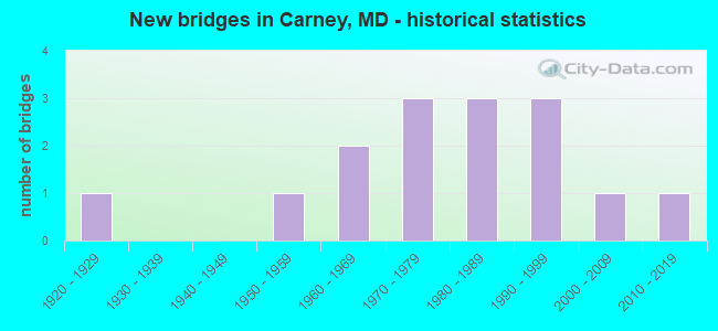
- New bridges - historical statistics
- 11920-1929
- 11950-1959
- 21960-1969
- 31970-1979
- 31980-1989
- 31990-1999
- 12000-2009
- 12010-2019


- Bridge Condition - Deck
- 14.3%Very good
- 71.4%Good
- 14.3%Satisfactory

- Bridge Condition - Superstructure
- 14.3%Excellent
- 85.7%Good

- Bridge Condition - Substructure
- 14.3%Excellent
- 71.4%Good
- 14.3%Satisfactory

- Bridge Condition - Channel
- 20.0%Good
- 40.0%Satisfactory
- 30.0%Fair
- 10.0%Poor

- Bridge Condition - Culverts
- 50.0%Good
- 16.7%Satisfactory
- 16.7%Fair
- 16.7%Poor
Find on map >> Show street view
Structure Number: 10000003016801, Location: 0.09 MI N OF MD 41 (Lat: 39.392889, Lng: -76.542767), Route carried "on" structure: County highway 3600, Year Built: 2017, Status: Open, Structure Length: 8.70m (28.54ft), Average Daily Traffic: 15,925 (year 2013), Truck Traffic: 4%, Average Future Daily Traffic: 18,675 (year 2033), Features Intersected: IS 695, Facility Carried by Structure: OLD HARFORD ROAD
Minimum Vertical Clearance: 30+ m (98+ ft), Kilometerpoint: 2.516, Lanes on structure: 3, Lanes under structure: 8, Owner: State Highway Agency, Approaching Roadway Width: 13.7m (44.9ft), Skew: 7 degrees, Material/Design: Steel, Design/Construction: Stringer/Multi-beam, Number Of Spans In Main Unit: 2, Length of Maximum Span: 43.0m (141.1ft), Curb or Sidewalk Widths: Left: 1.7m (5.6ft), Right: 1.7m (5.6ft), Curb-To-Curb Width: 13.8m (45.3ft), Out-to-Out Width: 18.1m (59.4ft)
Condition: Deck: Good, Superstructure: Excellent, Substructure: Excellent, Operating Rating: 54.1 metric tons, Method Used To Determine Operating Rating: Load and Resistance Factor Rating (LRFR) rating reported by rating factor(RF) method using HL-93 loadings, Inventory Rating: 41.8 metric tons, Method Used To Determine Inventory Rating: Load and Resistance Factor Rating (LRFR) rating reported by rating factor(RF) method using HL-93 loadings, Structural Evaluation: Superior to present desirable criteria, Deck Geometry: Somewhat better than minimum adequacy, Underclear: Equal to present minimum criteria, Approach Roadway Alignment: Equal to present desirable criteria, Designated Inspection Frequency: Every 24 months, Inspection Date: August 2021, Deck Structure Type: Concrete Cast-file-Place, Wearing Surface/Protective System: Wearing Surface: Integral Concrete, Deck Protection: Epoxy Coated Reinforcing
Find on map >> Show street view
Structure Number: 100000030173015, Location: 0.44 MI E OF MD 147 (Lat: 0.000108, Lng: -0.000019), Route carried "on" structure: Interstate 695, Year Built: 1993, Status: Open, Structure Length: 2.68m (8.79ft), Average Daily Traffic: 83,476 (year 2006), Truck Traffic: 8%, Average Future Daily Traffic: 90,154 (year 2026), Design Load: HS 20+Mod, Features Intersected: AVONDALE ROAD
Minimum Vertical Clearance: 30+ m (98+ ft), Kilometerpoint: 41.708, Lanes on structure: 6, Lanes under structure: 2, Base Highway Network: Yes, Owner: State Highway Agency, Approaching Roadway Width: 32.0m (105.0ft), Skew: 32 degrees, Material/Design: Steel, Design/Construction: Stringer/Multi-beam, Number Of Spans In Main Unit: 1, Length of Maximum Span: 25.3m (83.0ft), Curb-To-Curb Width: 31.7m (104.0ft), Out-to-Out Width: 34.0m (111.5ft)
Condition: Deck: Good, Superstructure: Good, Substructure: Good, Operating Rating: 76.2 metric tons, Method Used To Determine Operating Rating: Load Factor (LF), Inventory Rating: 45.8 metric tons, Method Used To Determine Inventory Rating: Load Factor (LF), Structural Evaluation: Better than present minimum criteria, Deck Geometry: Superior to present desirable criteria, Underclear: Meets minimum limits, Approach Roadway Alignment: Equal to present desirable criteria, Designated Inspection Frequency: Every 24 months, Inspection Date: November 2020, Deck Structure Type: Concrete Cast-file-Place, Wearing Surface/Protective System: Wearing Surface: Integral Concrete, Deck Protection: Epoxy Coated Reinforcing
Find on map >> Show street view
Structure Number: 100000030173016, Location: 0.44 MI E OF MD 147 (Lat: 0.000108, Lng: -0.000019), Route carried "on" structure: Interstate 695, Year Built: 1993, Status: Open, Structure Length: 2.59m (8.50ft), Average Daily Traffic: 83,476 (year 2006), Truck Traffic: 8%, Average Future Daily Traffic: 90,154 (year 2026), Design Load: HS 20+Mod, Features Intersected: AVONDALE ROAD
Minimum Vertical Clearance: 30+ m (98+ ft), Kilometerpoint: 41.708, Lanes on structure: 5, Lanes under structure: 2, Base Highway Network: Yes, Owner: State Highway Agency, Approaching Roadway Width: 25.6m (84.0ft), Skew: 2 degrees, Material/Design: Steel, Design/Construction: Stringer/Multi-beam, Number Of Spans In Main Unit: 1, Length of Maximum Span: 24.4m (80.1ft), Curb-To-Curb Width: 25.7m (84.3ft), Out-to-Out Width: 26.9m (88.3ft)
Condition: Deck: Very good, Superstructure: Good, Substructure: Good, Operating Rating: 76.2 metric tons, Method Used To Determine Operating Rating: Load Factor (LF), Inventory Rating: 45.8 metric tons, Method Used To Determine Inventory Rating: Load Factor (LF), Structural Evaluation: Better than present minimum criteria, Deck Geometry: Better than present minimum criteria, Underclear: High priority of corrective action, Approach Roadway Alignment: Equal to present desirable criteria, Designated Inspection Frequency: Every 24 months, Inspection Date: November 2020, Deck Structure Type: Concrete Cast-file-Place, Wearing Surface/Protective System: Wearing Surface: Integral Concrete, Deck Protection: Epoxy Coated Reinforcing
Find on map >> Show street view
Structure Number: 200000B-007501, Location: 0.02 MI E OF MD 567 (Lat: 39.425356, Lng: -76.529061), Route carried "on" structure: County highway 3887, Year Built: 1998, Status: Open, Structure Length: 7.56m (24.80ft), Average Daily Traffic: 14,402 (year 2021), Truck Traffic: 5%, Average Future Daily Traffic: 17,572 (year 2041), Features Intersected: GUNPOWDER FALLS, Facility Carried by Structure: GLEN ARM ROAD
Minimum Vertical Clearance: 30+ m (98+ ft), Kilometerpoint: 0.032, Lanes on structure: 2, Owner: County Highway Agency, Approaching Roadway Width: 9.1m (29.9ft), Skew: 4 degrees, Material/Design: Steel continuous, Design/Construction: Stringer/Multi-beam, Number Of Spans In Main Unit: 3, Length of Maximum Span: 27.4m (89.9ft), Curb or Sidewalk Widths: Left: 1.6m (5.2ft), Right: 0.0m, Curb-To-Curb Width: 9.1m (29.9ft), Out-to-Out Width: 11.5m (37.7ft)
Condition: Deck: Good, Superstructure: Good, Substructure: Good, Channel: Good, Operating Rating: 66.2 metric tons, Method Used To Determine Operating Rating: Load Factor (LF), Inventory Rating: 39.5 metric tons, Method Used To Determine Inventory Rating: Load Factor (LF), Structural Evaluation: Better than present minimum criteria, Deck Geometry: Meets minimum limits, Waterway Adequacy: Equal to present desirable criteria, Approach Roadway Alignment: High priority of corrective action, Designated Inspection Frequency: Every 24 months, Inspection Date: October 2021, Deck Structure Type: Concrete Cast-file-Place, Wearing Surface/Protective System: Wearing Surface: Integral Concrete, Deck Protection: Epoxy Coated Reinforcing
Find on map >> Show street view
Structure Number: 200000B-013301, Location: 0.6 MI E HARFORD RD (Lat: 39.406778, Lng: -76.503850), Route carried "on" structure: County highway 3785, Year Built: 1973, Status: Open, Structure Length: 2.44m (8.01ft), Average Daily Traffic: 10,959 (year 2019), Truck Traffic: 5%, Average Future Daily Traffic: 13,161 (year 2039), Design Load: HS 20, Features Intersected: JENNIFER BRANCH, Facility Carried by Structure: NORTH WIND ROAD
Minimum Vertical Clearance: 30+ m (98+ ft), Kilometerpoint: 0.708, Lanes on structure: 2, Owner: County Highway Agency, Approaching Roadway Width: 12.2m (40.0ft), Skew: 2 degrees, Material/Design: Steel, Design/Construction: Stringer/Multi-beam, Number Of Spans In Main Unit: 1, Length of Maximum Span: 22.9m (75.1ft), Curb or Sidewalk Widths: Left: 1.5m (4.9ft), Right: 1.5m (4.9ft), Curb-To-Curb Width: 12.2m (40.0ft), Out-to-Out Width: 15.9m (52.2ft)
Condition: Deck: Satisfactory, Superstructure: Good, Substructure: Good, Channel: Satisfactory, Operating Rating: 88.4 metric tons, Method Used To Determine Operating Rating: Load Factor (LF), Inventory Rating: 53.1 metric tons, Method Used To Determine Inventory Rating: Load Factor (LF), Structural Evaluation: Better than present minimum criteria, Deck Geometry: Somewhat better than minimum adequacy, Waterway Adequacy: Equal to present desirable criteria, Approach Roadway Alignment: Equal to present minimum criteria, Designated Inspection Frequency: Every 24 months, Inspection Date: March 2021, Deck Structure Type: Concrete Cast-file-Place, Wearing Surface/Protective System: Wearing Surface: Monolithic Concrete
Find on map >> Show street view
Structure Number: 200000B-022101, Location: 0.2 MI E OF CROMWELL BR R (Lat: 39.424444, Lng: -76.527778), Route carried "on" structure: County highway 3807, Year Built: 1920, Year Reconstructed: 1971, Status: Open, Structure Length: 0.94m (3.08ft), Average Daily Traffic: 7,580 (year 2019), Truck Traffic: 5%, Average Future Daily Traffic: 11,045 (year 2039), Features Intersected: BRANCH OF GUNPOWDER FALL, Facility Carried by Structure: CUB HILL ROAD
Minimum Vertical Clearance: 30+ m (98+ ft), Kilometerpoint: 0.097, Lanes on structure: 2, Owner: County Highway Agency, Approaching Roadway Width: 6.7m (22.0ft), Skew: 2 degrees, Material/Design: Concrete continuous, Design/Construction: Slab, Number Of Spans In Main Unit: 2, Length of Maximum Span: 4.9m (16.1ft), Curb or Sidewalk Widths: Left: 0.3m (1.0ft), Right: 0.3m (1.0ft), Curb-To-Curb Width: 5.9m (19.4ft), Out-to-Out Width: 6.6m (21.7ft)
Condition: Deck: Good, Superstructure: Good, Substructure: Satisfactory, Channel: Fair, Operating Rating: 59.4 metric tons, Method Used To Determine Operating Rating: Load Factor (LF), Inventory Rating: 35.4 metric tons, Method Used To Determine Inventory Rating: Load Factor (LF), Structural Evaluation: Equal to present minimum criteria, Deck Geometry: High priority of replacement, Waterway Adequacy: Equal to present minimum criteria, Approach Roadway Alignment: Equal to present minimum criteria, Designated Inspection Frequency: Every 24 months, Inspection Date: May 2021, Deck Structure Type: Concrete Cast-file-Place, Wearing Surface/Protective System: Wearing Surface: Bituminous
Find on map >> Show street view
Structure Number: 200000B-036502, Location: 0.2 MI E OF MD RTE 147 (Lat: 39.401908, Lng: -76.514203), Route carried "on" structure: County highway 3763, Year Built: 1978, Status: Posted for load, Structure Length: 0.70m (2.30ft), Average Daily Traffic: 647 (year 2021), Truck Traffic: 5%, Average Future Daily Traffic: 872 (year 2041), Design Load: HS 20, Features Intersected: JENNIFER BRANCH, Facility Carried by Structure: HOMELAND AVENUE
Minimum Vertical Clearance: 30+ m (98+ ft), Kilometerpoint: 0.048, Lanes on structure: 2, Owner: County Highway Agency, Approaching Roadway Width: 6.1m (20.0ft), Material/Design: Concrete, Design/Construction: Culvert, Number Of Spans In Main Unit: 2, Length of Maximum Span: 3.4m (11.2ft)
Condition: Channel: Satisfactory, Culverts: Good, Operating Rating: 29.9 metric tons, Method Used To Determine Operating Rating: Load Factor (LF), Inventory Rating: 18.1 metric tons, Method Used To Determine Inventory Rating: Load Factor (LF), Structural Evaluation: Somewhat better than minimum adequacy, Waterway Adequacy: Better than present minimum criteria, Approach Roadway Alignment: Equal to present desirable criteria, Bridge Posting: Required (Relationship of Operating Rating to Maximum Legal Load: 10.0 - 19.9% below), Length Of Structure Improvement: 1.37m (4.49ft), Designated Inspection Frequency: Every 12 months, Inspection Date: June 2021, Bridge Improvement Cost: $810,000, Roadway Improvement Cost: $81,000, Total Project Cost: $891,000
Find on map >> Show street view
Structure Number: 200000B-036602, Location: 0.05 MI W OF HOMELAND AVE (Lat: 39.402358, Lng: -76.513086), Route carried "on" structure: County highway 3764, Year Built: 1978, Status: Posted for load, Structure Length: 0.88m (2.89ft), Average Daily Traffic: 552 (year 2021), Truck Traffic: 10%, Average Future Daily Traffic: 820 (year 2041), Design Load: HS 20, Features Intersected: JENNIFER BRANCH, Facility Carried by Structure: SUMMIT AVENUE
Minimum Vertical Clearance: 30+ m (98+ ft), Kilometerpoint: 0.772, Lanes on structure: 2, Owner: County Highway Agency, Approaching Roadway Width: 7.3m (24.0ft), Skew: 1 degrees, Material/Design: Concrete, Design/Construction: Culvert, Number Of Spans In Main Unit: 2, Length of Maximum Span: 4.3m (14.1ft), Curb-To-Curb Width: 13.0m (42.7ft), Out-to-Out Width: 13.6m (44.6ft)
Condition: Channel: Satisfactory, Culverts: Good, Operating Rating: 23.6 metric tons, Method Used To Determine Operating Rating: Load Factor (LF), Inventory Rating: 14.1 metric tons, Method Used To Determine Inventory Rating: Load Factor (LF), Structural Evaluation: Meets minimum limits, Deck Geometry: Superior to present desirable criteria, Waterway Adequacy: Equal to present desirable criteria, Approach Roadway Alignment: Equal to present minimum criteria, Bridge Posting: Required (Relationship of Operating Rating to Maximum Legal Load: 30.0 - 39.9% below), Designated Inspection Frequency: Every 12 months, Inspection Date: June 2021
Find on map >> Show street view
Structure Number: 200000B-046303, Location: 0.2 MI N OF MD RTE 567 (Lat: 39.416519, Lng: -76.546319), Route carried "on" structure: County highway , Year Built: 2006, Status: Open, Structure Length: 1.72m (5.64ft), Average Daily Traffic: 300 (year 2013), Truck Traffic: 5%, Average Future Daily Traffic: 700 (year 2035), Features Intersected: MINEBANK RUN, Facility Carried by Structure: MERRICK ACCESS ROA
Minimum Vertical Clearance: 30+ m (98+ ft), Kilometerpoint: 0.000, Lanes on structure: 1, Owner: County Highway Agency, Approaching Roadway Width: 4.9m (16.1ft), Material/Design: Prestressed concrete, Design/Construction: Box Beam or Girders - Multiple, Number Of Spans In Main Unit: 1, Length of Maximum Span: 16.8m (55.1ft), Curb-To-Curb Width: 4.0m (13.1ft), Out-to-Out Width: 4.9m (16.1ft)
Condition: Deck: Good, Superstructure: Good, Substructure: Good, Channel: Good, Inventory Rating: 79.8 metric tons, Method Used To Determine Inventory Rating: Load Factor (LF), Structural Evaluation: Better than present minimum criteria, Deck Geometry: High priority of replacement, Waterway Adequacy: Equal to present minimum criteria, Approach Roadway Alignment: Equal to present minimum criteria, Designated Inspection Frequency: Every 24 months, Inspection Date: August 2021, Deck Structure Type: Concrete Cast-file-Place, Wearing Surface/Protective System: Wearing Surface: Monolithic Concrete, Deck Protection: Epoxy Coated Reinforcing
Find on map >> Show street view
Structure Number: 200000B-053003, Location: 2 MI NE EXIT 30 I-695 (Lat: 39.407592, Lng: -76.533689), Route carried "on" structure: Other road 6423, Year Built: 1980, Status: Open, Structure Length: 0.77m (2.53ft), Average Daily Traffic: 244 (year 2020), Truck Traffic: 5%, Average Future Daily Traffic: 377 (year 2042), Features Intersected: TRIBUTARY TO GUNPOWDER F, Facility Carried by Structure: EBONY ROAD
Minimum Vertical Clearance: 30+ m (98+ ft), Kilometerpoint: 0.000, Lanes on structure: 2, Owner: County Highway Agency, Approaching Roadway Width: 7.9m (25.9ft), Material/Design: Steel, Design/Construction: Culvert, Length of Maximum Span: 3.7m (12.1ft), Curb or Sidewalk Widths: Left: 1.2m (3.9ft), Right: 1.2m (3.9ft)
Condition: Channel: Satisfactory, Culverts: Fair, Structural Evaluation: Somewhat better than minimum adequacy, Waterway Adequacy: Better than present minimum criteria, Approach Roadway Alignment: Equal to present minimum criteria, Designated Inspection Frequency: Every 24 months, Inspection Date: March 2020
Find on map >> Show street view
Structure Number: 200000B-053103, Location: 1.9MI E OF EXIT 30 I-695 (Lat: 0.000108, Lng: -0.000214), Route carried "on" structure: Other road 3534, Year Built: 1980, Status: Open, Structure Length: 0.85m (2.79ft), Average Daily Traffic: 9,216 (year 2020), Truck Traffic: 5%, Average Future Daily Traffic: 14,247 (year 2042), Features Intersected: TRIBUTARY TO GUNPOWDER F, Facility Carried by Structure: WALTHAM WOODS ROAD
Minimum Vertical Clearance: 30+ m (98+ ft), Kilometerpoint: 0.000, Lanes on structure: 2, Owner: County Highway Agency, Approaching Roadway Width: 15.2m (49.9ft), Skew: 2 degrees, Material/Design: Steel, Design/Construction: Culvert, Length of Maximum Span: 3.7m (12.1ft), Curb or Sidewalk Widths: Left: 1.2m (3.9ft), Right: 1.2m (3.9ft)
Condition: Channel: Fair, Culverts: Good, Structural Evaluation: Better than present minimum criteria, Waterway Adequacy: Better than present minimum criteria, Approach Roadway Alignment: Equal to present minimum criteria, Designated Inspection Frequency: Every 24 months, Inspection Date: March 2020
Find on map >> Show street view
Structure Number: 200000B-053203, Location: 1.4 MI N OF JOPPA RD (Lat: 39.413664, Lng: -76.890625), Route carried "on" structure: Other road 6062, Year Built: 1980, Status: Open, Structure Length: 0.79m (2.59ft), Average Daily Traffic: 200 (year 2013), Truck Traffic: 5%, Average Future Daily Traffic: 210 (year 2040), Features Intersected: TRIBUTARY TO GUNPOWDER F, Facility Carried by Structure: BELLBECK ROAD
Minimum Vertical Clearance: 30+ m (98+ ft), Kilometerpoint: 0.000, Lanes on structure: 2, Owner: County Highway Agency, Approaching Roadway Width: 9.1m (29.9ft), Material/Design: Steel, Design/Construction: Culvert, Length of Maximum Span: 3.7m (12.1ft), Curb or Sidewalk Widths: Left: 1.2m (3.9ft), Right: 1.2m (3.9ft)
Condition: Channel: Poor, Culverts: Satisfactory, Structural Evaluation: Equal to present minimum criteria, Waterway Adequacy: Better than present minimum criteria, Approach Roadway Alignment: Equal to present desirable criteria, Designated Inspection Frequency: Every 24 months, Inspection Date: March 2020
Find on map >> Show street view
Structure Number: 200000B-059703, Location: 0.25 NE OF NORTH END MD41 (Lat: 39.405003, Lng: -76.535922), Route carried "on" structure: County highway , Year Built: 1960, Status: Open, Structure Length: 0.98m (3.22ft), Average Daily Traffic: 1,695 (year 2015), Truck Traffic: 5%, Average Future Daily Traffic: 2,095 (year 2037), Features Intersected: TRIBUTARY TO GUNPOWDER F, Facility Carried by Structure: COVERED BRIDGE ROA
Minimum Vertical Clearance: 30+ m (98+ ft), Kilometerpoint: 0.000, Lanes on structure: 2, Owner: County Highway Agency, Approaching Roadway Width: 9.1m (29.9ft), Skew: 4 degrees, Material/Design: Steel, Design/Construction: Culvert, Length of Maximum Span: 4.6m (15.1ft), Curb or Sidewalk Widths: Left: 1.2m (3.9ft), Right: 1.2m (3.9ft)
Condition: Channel: Fair, Culverts: Poor, Operating Rating: 59.4 metric tons, Method Used To Determine Operating Rating: Load Factor (LF), Inventory Rating: 35.4 metric tons, Method Used To Determine Inventory Rating: Load Factor (LF), Structural Evaluation: Meets minimum limits, Waterway Adequacy: Better than present minimum criteria, Approach Roadway Alignment: Equal to present desirable criteria, Designated Inspection Frequency: Every 24 months, Inspection Date: September 2020
Find on map >> Show street view
Structure Number: 10000003016401, Location: 0.17 MI W OF MD 542 (Lat: 39.401989, Lng: -76.568253), Route carried "under" structure: County highway 3353, Year Built: 1957, Structure Length: 0. m, Average Daily Traffic: 15,830 (year 2009), Features Intersected: CROMWELL BRIDGE ROAD, Facility Carried by Structure: IS 695
Minimum Vertical Clearance: 4.57m (14.99ft), Kilometerpoint: 1.545, Lanes on structure: 6, Lanes under structure: 4, Material/Design: Steel, Design/Construction: Stringer/Multi-beam, Length of Maximum Span: 26.2m (86.0ft)
Find on map >> Show street view
Structure Number: 10000003016701, Location: 0.33 M S OF JOPPA ROAD (Lat: 39.396853, Lng: -76.548681), Route carried "under" structure: State highway 41, Year Built: 1961, Structure Length: 0. m, Average Daily Traffic: 21,320 (year 2010), Features Intersected: MD 41, Facility Carried by Structure: IS 695
Minimum Vertical Clearance: 4.88m (16.01ft), Kilometerpoint: 3.652, Lanes on structure: 6, Lanes under structure: 4, Material/Design: Steel, Design/Construction: Stringer/Multi-beam, Length of Maximum Span: 16.2m (53.1ft)