Bridge Statistics for Carnegie, Pennsylvania (PA)
Condition, Traffic, Stress, Structural Evaluation, Project Costs
- National Bridge Inventory (NBI) Statistics
- 25Number of bridges
- 367ft / 112mTotal length
- $9,403,000Total costs
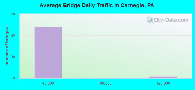
- 410,157Total average daily traffic
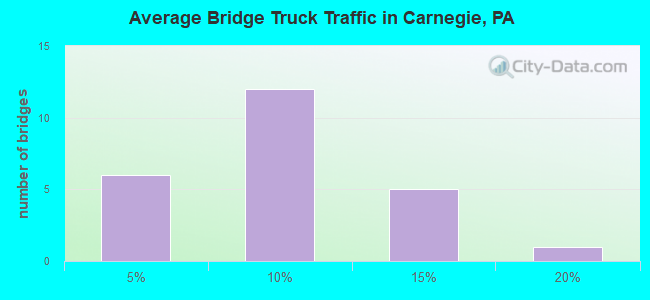
- 35,595Total average daily truck traffic
- National Bridge Inventory (NBI) Registered Bridges for Carnegie
- No street view available for this location
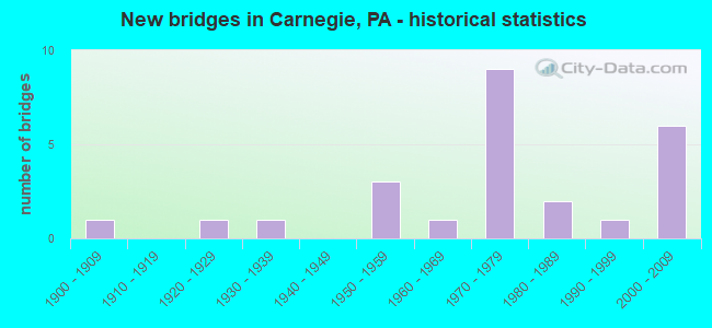
- New bridges - historical statistics
- 11900-1909
- 11920-1929
- 11930-1939
- 31950-1959
- 11960-1969
- 91970-1979
- 21980-1989
- 11990-1999
- 62000-2009
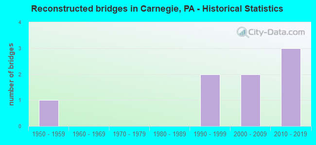
- Reconstructed bridges - Historical Statistics
- 11950-1959
- 01960-1969
- 01970-1979
- 01980-1989
- 21990-1999
- 22000-2009
- 32010-2019
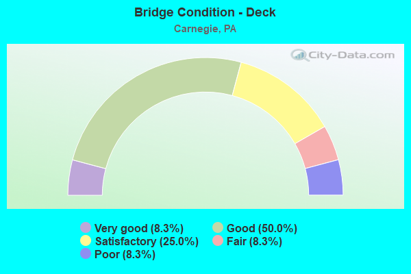
- Bridge Condition - Deck
- 8.3%Very good
- 50.0%Good
- 25.0%Satisfactory
- 8.3%Fair
- 8.3%Poor
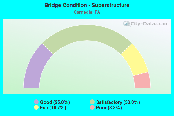
- Bridge Condition - Superstructure
- 25.0%Good
- 50.0%Satisfactory
- 16.7%Fair
- 8.3%Poor
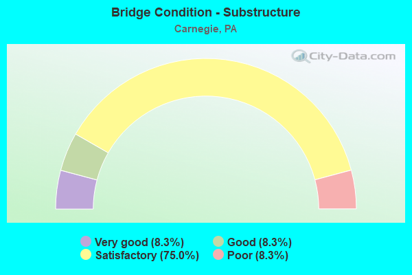
- Bridge Condition - Substructure
- 8.3%Very good
- 8.3%Good
- 75.0%Satisfactory
- 8.3%Poor
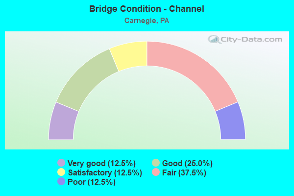
- Bridge Condition - Channel
- 12.5%Very good
- 25.0%Good
- 12.5%Satisfactory
- 37.5%Fair
- 12.5%Poor
Find on map >> Show street view
Structure Number: 975, Location: POC RR,BELL&ARCH ST (Lat: 40.415000, Lng: -80.084222), Route carried "on" structure: Interstate 376, Year Built: 1952, Year Reconstructed: 2016, Status: Open, Structure Length: 15.54m (50.98ft), Average Daily Traffic: 105,201 (year 2022), Truck Traffic: 5%, Average Future Daily Traffic: 97,504 (year 2032), Design Load: HS 20, Features Intersected: BUSWY,ARCH,BELL,POC RR, Facility Carried by Structure: PENN LINC PW
Minimum Vertical Clearance: 30+ m (98+ ft), Kilometerpoint: 25.424, Lanes on structure: 2, Lanes under structure: 4, Base Highway Network: Yes, Owner: State Highway Agency, Approaching Roadway Width: 21.9m (71.9ft), Skew: 30 degrees, Material/Design: Steel, Design/Construction: Stringer/Multi-beam, Number Of Spans In Main Unit: 5, Number Of Approach Spans: 1, Length of Maximum Span: 32.3m (106.0ft), Curb or Sidewalk Widths: Left: 0.2m (0.7ft), Right: 0.2m (0.7ft), Curb-To-Curb Width: 22.0m (72.2ft), Out-to-Out Width: 23.8m (78.1ft)
Condition: Deck: Good, Superstructure: Good, Substructure: Satisfactory, Operating Rating: 74.4 metric tons, Method Used To Determine Operating Rating: Load Factor (LF), Inventory Rating: 44.5 metric tons, Method Used To Determine Inventory Rating: Load Factor (LF), Structural Evaluation: Equal to present minimum criteria, Deck Geometry: Superior to present desirable criteria, Underclear: Meets minimum limits, Approach Roadway Alignment: Equal to present desirable criteria, Length Of Structure Improvement: 15.50m (50.85ft), Designated Inspection Frequency: Every 24 months, Inspection Date: August 2021, Bridge Improvement Cost: $247,000, Roadway Improvement Cost: $726,000, Total Project Cost: $3,330,000, Deck Structure Type: Concrete Cast-file-Place, Wearing Surface/Protective System: Wearing Surface: Monolithic Concrete, Deck Protection: Epoxy Coated Reinforcing
Find on map >> Show street view
Structure Number: 1782, Location: AT I-79 INTERCHANGE (Lat: 40.399283, Lng: -80.103172), Route carried "on" structure: State highway , Year Built: 1972, Year Reconstructed: 2021, Status: Open, Structure Length: 9.20m (30.18ft), Average Daily Traffic: 16,062 (year 2022), Truck Traffic: 6%, Average Future Daily Traffic: 11,640 (year 2039), Design Load: HL 93, Features Intersected: ROBINSON RUN, Facility Carried by Structure: NOBLESTOWN ROAD
Minimum Vertical Clearance: 30+ m (98+ ft), Kilometerpoint: 9.688, Lanes on structure: 2, Owner: State Highway Agency, Approaching Roadway Width: 24.1m (79.1ft), Skew: 23 degrees, Material/Design: Steel, Design/Construction: Stringer/Multi-beam, Number Of Spans In Main Unit: 3, Length of Maximum Span: 40.8m (133.9ft), Curb or Sidewalk Widths: Left: 0.2m (0.7ft), Right: 0.2m (0.7ft), Curb-To-Curb Width: 22.4m (73.5ft), Out-to-Out Width: 23.6m (77.4ft)
Condition: Deck: Very good, Superstructure: Satisfactory, Substructure: Satisfactory, Channel: Very good, Operating Rating: 55.4 metric tons, Method Used To Determine Operating Rating: Assigned ratings based on Load and Resistance Factor Design (LRFD) reported in metric tons, Inventory Rating: 42.6 metric tons, Method Used To Determine Inventory Rating: Assigned ratings based on Load and Resistance Factor Design (LRFD) reported in metric tons, Structural Evaluation: Equal to present minimum criteria, Deck Geometry: Superior to present desirable criteria, Waterway Adequacy: Superior to present desirable criteria, Approach Roadway Alignment: Equal to present desirable criteria, Length Of Structure Improvement: 9.20m (30.18ft), Designated Inspection Frequency: Every 24 months, Inspection Date: May 2021, Bridge Improvement Cost: $243,000, Roadway Improvement Cost: $715,000, Total Project Cost: $3,277,000, Deck Structure Type: Concrete Cast-file-Place, Wearing Surface/Protective System: Wearing Surface: Latex Concrete
Find on map >> Show street view
Structure Number: 1784, Location: O/CHARTIERS CR SR 3048 (Lat: 40.407750, Lng: -80.088286), Route carried "on" structure: State highway , Year Built: 1967, Year Reconstructed: 1999, Status: Open, Structure Length: 6.00m (19.69ft), Average Daily Traffic: 10,683 (year 2022), Truck Traffic: 7%, Average Future Daily Traffic: 16,462 (year 2032), Design Load: HS 20, Features Intersected: CHARTIERS CREEK, Facility Carried by Structure: MANSFIELD BLVD
Minimum Vertical Clearance: 30+ m (98+ ft), Kilometerpoint: 11.871, Lanes on structure: 5, Owner: State Highway Agency, Approaching Roadway Width: 22.9m (75.1ft), Skew: 23 degrees, Material/Design: Prestressed concrete, Design/Construction: Stringer/Multi-beam, Number Of Spans In Main Unit: 2, Length of Maximum Span: 29.0m (95.1ft), Curb or Sidewalk Widths: Left: 0.5m (1.6ft), Right: 1.5m (4.9ft), Curb-To-Curb Width: 20.1m (65.9ft), Out-to-Out Width: 22.9m (75.1ft)
Condition: Deck: Good, Superstructure: Satisfactory, Substructure: Satisfactory, Channel: Good, Operating Rating: 95.3 metric tons, Method Used To Determine Operating Rating: Load Factor (LF), Inventory Rating: 19.1 metric tons, Method Used To Determine Inventory Rating: Load Factor (LF), Structural Evaluation: Meets minimum limits, Deck Geometry: Somewhat better than minimum adequacy, Waterway Adequacy: Better than present minimum criteria, Approach Roadway Alignment: Equal to present desirable criteria, Length Of Structure Improvement: 6.00m (19.69ft), Designated Inspection Frequency: Every 24 months, Inspection Date: October 2020, Bridge Improvement Cost: $43,000, Roadway Improvement Cost: $127,000, Total Project Cost: $583,000, Deck Structure Type: Concrete Cast-file-Place, Wearing Surface/Protective System: Wearing Surface: Monolithic Concrete
Find on map >> Show street view
Structure Number: 1796, Location: 1/4 MI. N. CARN. I-79 INT (Lat: 40.404703, Lng: -80.107347), Route carried "on" structure: State highway , Year Built: 1972, Year Reconstructed: 2006, Status: Open, Structure Length: 11.67m (38.29ft), Average Daily Traffic: 2,137 (year 2022), Truck Traffic: 2%, Average Future Daily Traffic: 3,631 (year 2032), Design Load: HL 93, Features Intersected: SR 0079 NB-SB, Facility Carried by Structure: EWING ROAD
Minimum Vertical Clearance: 30+ m (98+ ft), Kilometerpoint: 6.009, Lanes on structure: 2, Lanes under structure: 12, Owner: State Highway Agency, Approaching Roadway Width: 8.8m (28.9ft), Skew: 4 degrees, Material/Design: Prestressed concrete, Design/Construction: Stringer/Multi-beam, Number Of Spans In Main Unit: 4, Length of Maximum Span: 43.3m (142.1ft), Curb or Sidewalk Widths: Left: 0.2m (0.7ft), Right: 0.2m (0.7ft), Curb-To-Curb Width: 11.0m (36.1ft), Out-to-Out Width: 12.0m (39.4ft)
Condition: Deck: Good, Superstructure: Good, Substructure: Good, Operating Rating: 98.0 metric tons, Method Used To Determine Operating Rating: Load and Resistance Factor (LRFR), Inventory Rating: 47.2 metric tons, Method Used To Determine Inventory Rating: Load and Resistance Factor (LRFR), Structural Evaluation: Better than present minimum criteria, Deck Geometry: Somewhat better than minimum adequacy, Underclear: Meets minimum limits, Approach Roadway Alignment: Better than present minimum criteria, Length Of Structure Improvement: 11.60m (38.06ft), Designated Inspection Frequency: Every 24 months, Inspection Date: May 2021, Bridge Improvement Cost: $97,000, Roadway Improvement Cost: $284,000, Total Project Cost: $1,304,000, Deck Structure Type: Concrete Cast-file-Place, Wearing Surface/Protective System: Wearing Surface: Monolithic Concrete, Deck Protection: Epoxy Coated Reinforcing
Find on map >> Show street view
Structure Number: 1798, Location: 2300'SOUTH OF SR 3058 (Lat: 40.407036, Lng: -80.076253), Route carried "on" structure: State highway , Year Built: 1992, Status: Open, Structure Length: 2.74m (8.99ft), Average Daily Traffic: 10,750 (year 2020), Truck Traffic: 1%, Average Future Daily Traffic: 16,506 (year 2032), Design Load: HS 20, Features Intersected: WHEELING & LE RR, Facility Carried by Structure: FORSYTHE RD
Minimum Vertical Clearance: 30+ m (98+ ft), Kilometerpoint: 0.694, Lanes on structure: 2, Owner: State Highway Agency, Approaching Roadway Width: 7.3m (24.0ft), Skew: 3 degrees, Material/Design: Prestressed concrete, Design/Construction: Box Beam or Girders - Multiple, Number Of Spans In Main Unit: 1, Length of Maximum Span: 26.8m (87.9ft), Curb or Sidewalk Widths: Left: 0.0m, Right: 1.8m (5.9ft), Curb-To-Curb Width: 8.5m (27.9ft), Out-to-Out Width: 11.4m (37.4ft)
Condition: Deck: Satisfactory, Superstructure: Satisfactory, Substructure: Satisfactory, Inventory Rating: 49.9 metric tons, Method Used To Determine Inventory Rating: Load Factor (LF), Structural Evaluation: Equal to present minimum criteria, Deck Geometry: High priority of replacement, Underclear: High priority of corrective action, Approach Roadway Alignment: Equal to present desirable criteria, Length Of Structure Improvement: 3.50m (11.48ft), Designated Inspection Frequency: Every 48 months, Inspection Date: March 2021, Deck Structure Type: Concrete Cast-file-Place, Wearing Surface/Protective System: Wearing Surface: Monolithic Concrete, Deck Protection: Epoxy Coated Reinforcing
Find on map >> Show street view
Structure Number: 2564, Location: CC04 CHARTIERS CRK # 4 (Lat: 40.411883, Lng: -80.084125), Route carried "on" structure: City street , Year Built: 1983, Year Reconstructed: 2015, Status: Open, Structure Length: 5.61m (18.41ft), Average Daily Traffic: 5,924 (year 2006), Truck Traffic: 6%, Average Future Daily Traffic: 10,314 (year 2028), Design Load: HS 20, Features Intersected: CHARTIERS CREEK, Facility Carried by Structure: CHESTNUT ST
Minimum Vertical Clearance: 30+ m (98+ ft), Kilometerpoint: 0.000, Lanes on structure: 2, Owner: County Highway Agency, Approaching Roadway Width: 9.1m (29.9ft), Skew: 1 degrees, Material/Design: Steel continuous, Design/Construction: Stringer/Multi-beam, Number Of Spans In Main Unit: 2, Length of Maximum Span: 27.4m (89.9ft), Curb or Sidewalk Widths: Left: 1.6m (5.2ft), Right: 1.6m (5.2ft), Curb-To-Curb Width: 9.1m (29.9ft), Out-to-Out Width: 13.9m (45.6ft)
Condition: Deck: Good, Superstructure: Satisfactory, Substructure: Satisfactory, Channel: Fair, Operating Rating: 55.3 metric tons, Method Used To Determine Operating Rating: Load Factor (LF), Inventory Rating: 33.6 metric tons, Method Used To Determine Inventory Rating: Load Factor (LF), Structural Evaluation: Equal to present minimum criteria, Deck Geometry: High priority of corrective action, Waterway Adequacy: Equal to present desirable criteria, Approach Roadway Alignment: Better than present minimum criteria, Length Of Structure Improvement: 5.60m (18.37ft), Designated Inspection Frequency: Every 24 months, Underwater Inspection Frequency: Every 60 months, Inspection Date: March 2021, Underwater Inspection Date: May 2017, Bridge Improvement Cost: $33,000, Roadway Improvement Cost: $98,000, Total Project Cost: $448,000, Deck Structure Type: Concrete Cast-file-Place, Wearing Surface/Protective System: Wearing Surface: Monolithic Concrete, Deck Protection: Epoxy Coated Reinforcing
Find on map >> Show street view
Structure Number: 2565, Location: CC06 CHARTIERS CRK # 6 (Lat: 40.402236, Lng: -80.088639), Route carried "on" structure: City street , Year Built: 1927, Year Reconstructed: 2014, Status: Open, Structure Length: 4.45m (14.60ft), Average Daily Traffic: 8,513 (year 2006), Truck Traffic: 4%, Average Future Daily Traffic: 14,821 (year 2026), Design Load: HS 20, Features Intersected: CHARTIERS CREEK, Facility Carried by Structure: CAROTHERS ST
Minimum Vertical Clearance: 30+ m (98+ ft), Kilometerpoint: 0.000, Lanes on structure: 2, Owner: County Highway Agency, Approaching Roadway Width: 9.1m (29.9ft), Material/Design: Steel, Design/Construction: Truss - Thru, Number Of Spans In Main Unit: 1, Length of Maximum Span: 42.7m (140.1ft), Curb or Sidewalk Widths: Left: 1.7m (5.6ft), Right: 1.7m (5.6ft), Curb-To-Curb Width: 8.5m (27.9ft), Out-to-Out Width: 9.9m (32.5ft)
Condition: Deck: Satisfactory, Superstructure: Fair, Substructure: Satisfactory, Channel: Satisfactory, Operating Rating: 72.6 metric tons, Method Used To Determine Operating Rating: Load Factor (LF), Inventory Rating: 43.5 metric tons, Method Used To Determine Inventory Rating: Load Factor (LF), Structural Evaluation: Somewhat better than minimum adequacy, Deck Geometry: High priority of replacement, Waterway Adequacy: Superior to present desirable criteria, Approach Roadway Alignment: Equal to present minimum criteria, Length Of Structure Improvement: 4.40m (14.44ft), Designated Inspection Frequency: Every 24 months, Critical Feature Inspection Frequency: Every 24 months, Inspection Date: December 2020, Critical Feature Inspection Date: December 2020, Bridge Improvement Cost: $14,000, Roadway Improvement Cost: $40,000, Total Project Cost: $186,000, Deck Structure Type: Corrugated Steel, Wearing Surface/Protective System: Wearing Surface: Latex Concrete
Find on map >> Show street view
Structure Number: 2566, Location: CC16 CHARTIERS CRK # 16 (Lat: 40.400408, Lng: -80.096878), Route carried "on" structure: City street , Year Built: 1984, Year Reconstructed: 2015, Status: Open, Structure Length: 4.39m (14.40ft), Average Daily Traffic: 3,127 (year 2005), Truck Traffic: 6%, Average Future Daily Traffic: 5,444 (year 2022), Design Load: HS 20, Features Intersected: CHARTIERS CREEK, Facility Carried by Structure: HAMMOND ST
Minimum Vertical Clearance: 30+ m (98+ ft), Kilometerpoint: 0.000, Lanes on structure: 2, Owner: County Highway Agency, Approaching Roadway Width: 7.3m (24.0ft), Material/Design: Steel, Design/Construction: Stringer/Multi-beam, Number Of Spans In Main Unit: 2, Length of Maximum Span: 24.1m (79.1ft), Curb or Sidewalk Widths: Left: 0.2m (0.7ft), Right: 1.7m (5.6ft), Curb-To-Curb Width: 9.1m (29.9ft), Out-to-Out Width: 12.0m (39.4ft)
Condition: Deck: Good, Superstructure: Satisfactory, Substructure: Satisfactory, Channel: Fair, Operating Rating: 92.5 metric tons, Method Used To Determine Operating Rating: Load Factor (LF), Inventory Rating: 55.3 metric tons, Method Used To Determine Inventory Rating: Load Factor (LF), Structural Evaluation: Equal to present minimum criteria, Deck Geometry: Meets minimum limits, Waterway Adequacy: Equal to present desirable criteria, Approach Roadway Alignment: Meets minimum limits, Length Of Structure Improvement: 4.40m (14.44ft), Designated Inspection Frequency: Every 24 months, Underwater Inspection Frequency: Every 60 months, Inspection Date: March 2021, Underwater Inspection Date: May 2020, Bridge Improvement Cost: $9,000, Roadway Improvement Cost: $28,000, Total Project Cost: $118,000, Deck Structure Type: Concrete Cast-file-Place, Wearing Surface/Protective System: Wearing Surface: Monolithic Concrete, Deck Protection: Epoxy Coated Reinforcing
Find on map >> Show street view
Structure Number: 2567, Location: CM03 INT CAMPBELLS RN R (Lat: 40.408061, Lng: -80.090139), Route carried "on" structure: City street , Year Built: 1902, Year Reconstructed: 1957, Status: Open, Structure Length: 1.68m (5.51ft), Average Daily Traffic: 2,938 (year 2019), Truck Traffic: 2%, Average Future Daily Traffic: 3,673 (year 2039), Design Load: HS 20, Features Intersected: CAMPBELLS RUN, Facility Carried by Structure: RAILROAD AV
Minimum Vertical Clearance: 30+ m (98+ ft), Kilometerpoint: 0.000, Lanes on structure: 2, Owner: County Highway Agency, Approaching Roadway Width: 6.7m (22.0ft), Skew: 5 degrees, Material/Design: Prestressed concrete, Design/Construction: Box Beam or Girders - Multiple, Number Of Spans In Main Unit: 1, Length of Maximum Span: 16.2m (53.1ft), Curb or Sidewalk Widths: Left: 2.0m (6.6ft), Right: 2.0m (6.6ft), Curb-To-Curb Width: 6.0m (19.7ft), Out-to-Out Width: 10.2m (33.5ft)
Condition: Deck: Fair, Superstructure: Fair, Substructure: Satisfactory, Channel: Good, Operating Rating: 41.7 metric tons, Method Used To Determine Operating Rating: Load Factor (LF), Inventory Rating: 17.2 metric tons, Method Used To Determine Inventory Rating: Load Factor (LF), Structural Evaluation: Meets minimum limits, Deck Geometry: High priority of replacement, Waterway Adequacy: Equal to present desirable criteria, Approach Roadway Alignment: Equal to present desirable criteria, Length Of Structure Improvement: 2.10m (6.89ft), Designated Inspection Frequency: Every 24 months, Inspection Date: April 2021, Bridge Improvement Cost: $12,000, Roadway Improvement Cost: $50,000, Total Project Cost: $157,000, Deck Structure Type: Other, Wearing Surface/Protective System: Wearing Surface: Bituminous
Find on map >> Show street view
Structure Number: 42057, Location: 1/4 MILE SW CARNEGIE (Lat: 40.406767, Lng: -80.088058), Route carried "on" structure: City street , Year Built: 1934, Year Reconstructed: 2002, Status: Open, Structure Length: 4.21m (13.81ft), Average Daily Traffic: 1,200 (year 2019), Truck Traffic: 1%, Average Future Daily Traffic: 1,325 (year 2041), Features Intersected: CHARTIERS CREEK, Facility Carried by Structure: EAST MAIN STREET
Minimum Vertical Clearance: 30+ m (98+ ft), Kilometerpoint: 0.000, Lanes on structure: 2, Owner: City or Municipal Highway Agency, Approaching Roadway Width: 6.7m (22.0ft), Material/Design: Concrete, Design/Construction: Frame, Number Of Spans In Main Unit: 2, Length of Maximum Span: 21.6m (70.9ft), Curb or Sidewalk Widths: Left: 4.8m (15.7ft), Right: 4.8m (15.7ft), Curb-To-Curb Width: 6.7m (22.0ft), Out-to-Out Width: 16.7m (54.8ft)
Condition: Deck: Poor, Superstructure: Poor, Substructure: Poor, Channel: Fair, Operating Rating: 32.7 metric tons, Method Used To Determine Operating Rating: Field evaluation and documented engineering judgment, Inventory Rating: 19.1 metric tons, Method Used To Determine Inventory Rating: Field evaluation and documented engineering judgment, Structural Evaluation: Meets minimum limits, Deck Geometry: High priority of corrective action, Waterway Adequacy: Better than present minimum criteria, Approach Roadway Alignment: Equal to present desirable criteria, Length Of Structure Improvement: 4.90m (16.08ft), Designated Inspection Frequency: Every 24 months, Underwater Inspection Frequency: Every 24 months, Inspection Date: August 2021, Underwater Inspection Date: June 2020, Wearing Surface/Protective System: Wearing Surface: Bituminous
Find on map >> Show street view
Structure Number: 45197, Location: 79/376 INTERCHANGE (Lat: 40.416667, Lng: -80.106667), Route carried "on" structure: Ramp State highway , Year Built: 2008, Status: Open, Structure Length: 45.29m (148.59ft), Average Daily Traffic: 6,065 (year 2021), Truck Traffic: 7%, Average Future Daily Traffic: 7,529 (year 2032), Design Load: HS 20, Features Intersected: I-79,376E&W, CAMBLS RNRD, Facility Carried by Structure: SR 8009 RAMP G
Minimum Vertical Clearance: 30+ m (98+ ft), Kilometerpoint: 0.000, Lanes on structure: 1, Lanes under structure: 13, Base Highway Network: Yes, Owner: State Highway Agency, Approaching Roadway Width: 8.8m (28.9ft), Skew: 30 degrees, Material/Design: Steel continuous, Design/Construction: Stringer/Multi-beam, Number Of Spans In Main Unit: 7, Length of Maximum Span: 72.5m (237.9ft), Curb-To-Curb Width: 8.8m (28.9ft), Out-to-Out Width: 9.9m (32.5ft)
Condition: Deck: Good, Superstructure: Good, Substructure: Very good, Operating Rating: 77.1 metric tons, Method Used To Determine Operating Rating: Load Factor (LF), Inventory Rating: 46.3 metric tons, Method Used To Determine Inventory Rating: Load Factor (LF), Structural Evaluation: Better than present minimum criteria, Deck Geometry: Superior to present desirable criteria, Underclear: High priority of corrective action, Approach Roadway Alignment: Better than present minimum criteria, Designated Inspection Frequency: Every 48 months, Inspection Date: June 2018, Deck Structure Type: Concrete Cast-file-Place, Wearing Surface/Protective System: Wearing Surface: Monolithic Concrete, Deck Protection: Epoxy Coated Reinforcing
Find on map >> Show street view
Structure Number: 45929, Location: 1 mile north of Glendale (Lat: 40.410297, Lng: -80.091717), Route carried "on" structure: City street , Year Built: 1973, Status: Open, Structure Length: 0.85m (2.79ft), Average Daily Traffic: 150 (year 2019), Truck Traffic: 1%, Average Future Daily Traffic: 160 (year 2041), Design Load: HL 93, Features Intersected: Trib of Chartiers Cr, Facility Carried by Structure: Morrow St
Minimum Vertical Clearance: 30+ m (98+ ft), Kilometerpoint: 0.000, Lanes on structure: 2, Owner: Town or Township Highway Agency, Approaching Roadway Width: 6.7m (22.0ft), Skew: 3 degrees, Material/Design: Steel, Design/Construction: Stringer/Multi-beam, Number Of Spans In Main Unit: 1, Length of Maximum Span: 7.6m (24.9ft), Curb or Sidewalk Widths: Left: 1.2m (3.9ft), Right: 1.2m (3.9ft), Curb-To-Curb Width: 7.6m (24.9ft), Out-to-Out Width: 10.6m (34.8ft)
Condition: Deck: Satisfactory, Superstructure: Satisfactory, Substructure: Satisfactory, Channel: Poor, Operating Rating: 49.0 metric tons, Method Used To Determine Operating Rating: Load Factor (LF), Inventory Rating: 29.0 metric tons, Method Used To Determine Inventory Rating: Load Factor (LF), Structural Evaluation: Equal to present minimum criteria, Deck Geometry: Somewhat better than minimum adequacy, Waterway Adequacy: Equal to present minimum criteria, Approach Roadway Alignment: Equal to present desirable criteria, Designated Inspection Frequency: Every 24 months, Inspection Date: May 2021, Deck Structure Type: Concrete Cast-file-Place, Wearing Surface/Protective System: Wearing Surface: Monolithic Concrete
Find on map >> Show street view
Structure Number: 866, Location: I 79 NB OVER SR 3048 (Lat: 40.398525, Lng: -80.104769), Route carried "under" structure: State highway , Year Built: 1972, Structure Length: 0. m, Average Daily Traffic: 7,207 (year 2022), Truck Traffic: 5%, Features Intersected: SR 3048-NOBLESTOWN RD., Facility Carried by Structure: RAYMOND SHAFER HW
Minimum Vertical Clearance: 5.18m (16.99ft), Kilometerpoint: 9.688, Lanes on structure: 4, Lanes under structure: 5, Material/Design: Steel, Design/Construction: Stringer/Multi-beam, Length of Maximum Span: 35.1m (115.2ft)
Find on map >> Show street view
Structure Number: 866, Location: I 79 NB OVER SR 3048 (Lat: 40.398525, Lng: -80.104769), Route carried "under" structure: State highway , Year Built: 1972, Structure Length: 0. m, Average Daily Traffic: 2,677 (year 2022), Truck Traffic: 10%, Features Intersected: SR 3048-NOBLESTOWN RD., Facility Carried by Structure: RAYMOND SHAFER HW
Minimum Vertical Clearance: 5.87m (19.26ft), Kilometerpoint: 9.688, Lanes on structure: 4, Lanes under structure: 5, Material/Design: Steel, Design/Construction: Stringer/Multi-beam, Length of Maximum Span: 35.1m (115.2ft)
Find on map >> Show street view
Structure Number: 868, Location: I 79 SB OVER SR 3048 (Lat: 40.400000, Lng: -80.100000), Route carried "under" structure: State highway , Year Built: 1972, Structure Length: 0. m, Average Daily Traffic: 2,677 (year 2022), Truck Traffic: 10%, Features Intersected: NOBLESTOWN RD., Facility Carried by Structure: RAYMOND SHAFER HW
Minimum Vertical Clearance: 5.41m (17.75ft), Kilometerpoint: 9.688, Lanes on structure: 4, Lanes under structure: 2, Material/Design: Steel, Design/Construction: Stringer/Multi-beam, Length of Maximum Span: 35.1m (115.2ft)
Find on map >> Show street view
Structure Number: 868, Location: I 79 SB OVER SR 3048 (Lat: 40.400000, Lng: -80.100000), Route carried "under" structure: State highway , Year Built: 1972, Structure Length: 0. m, Average Daily Traffic: 7,207 (year 2022), Truck Traffic: 5%, Features Intersected: NOBLESTOWN RD., Facility Carried by Structure: RAYMOND SHAFER HW
Minimum Vertical Clearance: 5.11m (16.77ft), Kilometerpoint: 9.688, Lanes on structure: 4, Lanes under structure: 2, Material/Design: Steel, Design/Construction: Stringer/Multi-beam, Length of Maximum Span: 35.1m (115.2ft)
Find on map >> Show street view
Structure Number: 975, Location: POC RR,BELL&ARCH ST (Lat: 40.415000, Lng: -80.084222), Route carried "under" structure: City street , Year Built: 1952, Structure Length: 0. m, Average Daily Traffic: 50 (year 2017), Features Intersected: BUSWY,ARCH,BELL,POC RR, Facility Carried by Structure: PENN LINC PW
Minimum Vertical Clearance: 12.74m (41.80ft), Kilometerpoint: 0.000, Lanes on structure: 2, Lanes under structure: 2, Material/Design: Steel, Design/Construction: Stringer/Multi-beam, Length of Maximum Span: 32.3m (106.0ft)
Find on map >> Show street view
Structure Number: 975, Location: POC RR,BELL&ARCH ST (Lat: 40.415000, Lng: -80.084222), Route carried "under" structure: City street , Year Built: 1952, Structure Length: 0. m, Average Daily Traffic: 1,000 (year 2017), Truck Traffic: 5%, Features Intersected: BUSWY,ARCH,BELL,POC RR, Facility Carried by Structure: PENN LINC PW
Minimum Vertical Clearance: 12.25m (40.19ft), Kilometerpoint: 0.000, Lanes on structure: 2, Lanes under structure: 2, Material/Design: Steel, Design/Construction: Stringer/Multi-beam, Length of Maximum Span: 32.3m (106.0ft)
Find on map >> Show street view
Structure Number: 1796, Location: 1/4 MI. N. CARN. I-79 INT (Lat: 40.404703, Lng: -80.107347), Route carried "under" structure: Interstate 79, Year Built: 1972, Structure Length: 0. m, Average Daily Traffic: 36,259 (year 2022), Truck Traffic: 12%, Features Intersected: SR 0079 NB-SB, Facility Carried by Structure: EWING ROAD
Minimum Vertical Clearance: 5.03m (16.50ft), Kilometerpoint: 11.074, Lanes on structure: 2, Lanes under structure: 6, Material/Design: Prestressed concrete, Design/Construction: Stringer/Multi-beam, Length of Maximum Span: 43.3m (142.1ft)
Find on map >> Show street view
Structure Number: 1796, Location: 1/4 MI. N. CARN. I-79 INT (Lat: 40.404703, Lng: -80.107347), Route carried "under" structure: Interstate 79, Year Built: 1972, Structure Length: 0. m, Average Daily Traffic: 33,286 (year 2022), Truck Traffic: 12%, Features Intersected: SR 0079 NB-SB, Facility Carried by Structure: EWING ROAD
Minimum Vertical Clearance: 5.03m (16.50ft), Kilometerpoint: 11.080, Lanes on structure: 2, Lanes under structure: 6, Material/Design: Prestressed concrete, Design/Construction: Stringer/Multi-beam, Length of Maximum Span: 43.3m (142.1ft)
Find on map >> Show street view
Structure Number: 45197, Location: 79/376 INTERCHANGE (Lat: 40.416667, Lng: -80.106667), Route carried "under" structure: Interstate 376, Year Built: 2008, Structure Length: 0. m, Average Daily Traffic: 38,532 (year 2022), Truck Traffic: 9%, Features Intersected: I-79,376E&W, CAMBLS RNRD, Facility Carried by Structure: SR 8009 RAMP G
Minimum Vertical Clearance: 30+ m (98+ ft), Kilometerpoint: 23.018, Lanes on structure: 1, Lanes under structure: 2, Material/Design: Steel continuous, Design/Construction: Stringer/Multi-beam, Length of Maximum Span: 72.5m (237.9ft)
Find on map >> Show street view
Structure Number: 45197, Location: 79/376 INTERCHANGE (Lat: 40.416667, Lng: -80.106667), Route carried "under" structure: Ramp State highway , Year Built: 2008, Structure Length: 0. m, Average Daily Traffic: 4,585 (year 2021), Truck Traffic: 7%, Features Intersected: I-79,376E&W, CAMBLS RNRD, Facility Carried by Structure: SR 8009 RAMP G
Minimum Vertical Clearance: 30+ m (98+ ft), Kilometerpoint: 0.000, Lanes on structure: 1, Lanes under structure: 1, Material/Design: Steel continuous, Design/Construction: Stringer/Multi-beam, Length of Maximum Span: 72.5m (237.9ft)
Find on map >> Show street view
Structure Number: 45197, Location: 79/376 INTERCHANGE (Lat: 40.416667, Lng: -80.106667), Route carried "under" structure: Interstate 79, Year Built: 2008, Structure Length: 0. m, Average Daily Traffic: 31,419 (year 2021), Truck Traffic: 14%, Features Intersected: I-79,376E&W, CAMBLS RNRD, Facility Carried by Structure: SR 8009 RAMP G
Minimum Vertical Clearance: 30+ m (98+ ft), Kilometerpoint: 13.481, Lanes on structure: 1, Lanes under structure: 3, Material/Design: Steel continuous, Design/Construction: Stringer/Multi-beam, Length of Maximum Span: 72.5m (237.9ft)
Find on map >> Show street view
Structure Number: 45197, Location: 79/376 INTERCHANGE (Lat: 40.416667, Lng: -80.106667), Route carried "under" structure: Interstate 79, Year Built: 2008, Structure Length: 0. m, Average Daily Traffic: 34,254 (year 2021), Truck Traffic: 17%, Features Intersected: I-79,376E&W, CAMBLS RNRD, Facility Carried by Structure: SR 8009 RAMP G
Minimum Vertical Clearance: 30+ m (98+ ft), Kilometerpoint: 13.488, Lanes on structure: 1, Lanes under structure: 3, Material/Design: Steel continuous, Design/Construction: Stringer/Multi-beam, Length of Maximum Span: 72.5m (237.9ft)
Find on map >> Show street view
Structure Number: 45197, Location: 79/376 INTERCHANGE (Lat: 40.416667, Lng: -80.106667), Route carried "under" structure: Interstate 376, Year Built: 2008, Structure Length: 0. m, Average Daily Traffic: 38,254 (year 2022), Truck Traffic: 9%, Features Intersected: I-79,376E&W, CAMBLS RNRD, Facility Carried by Structure: SR 8009 RAMP G
Minimum Vertical Clearance: 30+ m (98+ ft), Kilometerpoint: 23.031, Lanes on structure: 1, Lanes under structure: 2, Material/Design: Steel continuous, Design/Construction: Stringer/Multi-beam, Length of Maximum Span: 72.5m (237.9ft)