Bridge Statistics for Capitola, California (CA)
Condition, Traffic, Stress, Structural Evaluation, Project Costs
- National Bridge Inventory (NBI) Statistics
- 19Number of bridges
- 187ft / 57.2mTotal length
- $880,000Total costs
- 657,519Total average daily traffic
- 24,594Total average daily truck traffic
- National Bridge Inventory (NBI) Registered Bridges for Capitola
- No street view available for this location
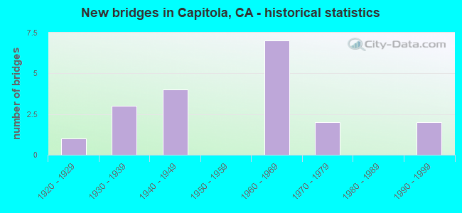
- New bridges - historical statistics
- 11920-1929
- 31930-1939
- 41940-1949
- 71960-1969
- 21970-1979
- 21990-1999

- Reconstructed bridges - Historical Statistics
- 21980-1989
- 11990-1999


- Bridge Condition - Deck
- 81.8%Good
- 9.1%Fair
- 9.1%Poor

- Bridge Condition - Superstructure
- 81.8%Good
- 18.2%Fair

- Bridge Condition - Substructure
- 90.9%Good
- 9.1%Fair

- Bridge Condition - Channel
- 20.0%Very good
- 40.0%Satisfactory
- 20.0%Fair
- 20.0%Poor
Find on map >> Show street view
Structure Number: 36 001, Location: 05-SCR-236-1.03 (Lat: 37.131983, Lng: -122.137114), Route carried "on" structure: State highway 236, Year Built: 1921, Status: Open, Structure Length: 2.35m (7.71ft), Average Daily Traffic: 1,350 (year 2017), Truck Traffic: 4%, Average Future Daily Traffic: 1,754 (year 2042), Features Intersected: BOULDER CREEK
Minimum Vertical Clearance: 30+ m (98+ ft), Kilometerpoint: 1.030, Lanes on structure: 2, Owner: State Highway Agency, Approaching Roadway Width: 6.7m (22.0ft), Material/Design: Concrete, Design/Construction: Arch - Deck, Number Of Spans In Main Unit: 1, Length of Maximum Span: 16.8m (55.1ft), Curb or Sidewalk Widths: Left: 0.1m (0.3ft), Right: 0.1m (0.3ft), Curb-To-Curb Width: 6.4m (21.0ft), Out-to-Out Width: 7.2m (23.6ft)
Condition: Deck: Good, Superstructure: Good, Substructure: Good, Channel: Satisfactory, Operating Rating: 25.9 metric tons, Method Used To Determine Operating Rating: Load Factor (LF), Inventory Rating: 15.6 metric tons, Method Used To Determine Inventory Rating: Load Factor (LF), Structural Evaluation: Meets minimum limits, Deck Geometry: High priority of replacement, Waterway Adequacy: Equal to present desirable criteria, Approach Roadway Alignment: High priority of corrective action, Designated Inspection Frequency: Every 24 months, Inspection Date: May 2020, Deck Structure Type: Concrete Cast-file-Place, Wearing Surface/Protective System: Wearing Surface: Bituminous
Find on map >> Show street view
Structure Number: 36 0013, Location: 05-SCR-001-13.31-CPTL (Lat: 36.983136, Lng: -121.959386), Route carried "on" structure: State highway 1, Year Built: 1947, Year Reconstructed: 1995, Status: Open, Structure Length: 9.85m (32.32ft), Average Daily Traffic: 97,000 (year 2019), Truck Traffic: 4%, Average Future Daily Traffic: 160,823 (year 2043), Design Load: HS 20, Features Intersected: SOQUEL CREEK, WHARF RD
Minimum Vertical Clearance: 30+ m (98+ ft), Kilometerpoint: 13.310, Lanes on structure: 6, Lanes under structure: 2, Base Highway Network: Yes (, Subroute: 1), Owner: State Highway Agency, Approaching Roadway Width: 29.3m (96.1ft), Skew: 30 degrees, Material/Design: Concrete, Design/Construction: Arch - Deck, Number Of Spans In Main Unit: 1, Number Of Approach Spans: 10, Length of Maximum Span: 38.4m (126.0ft), Curb-To-Curb Width: 29.4m (96.5ft), Out-to-Out Width: 31.0m (101.7ft)
Condition: Deck: Good, Superstructure: Good, Substructure: Good, Channel: Poor, Operating Rating: 53.1 metric tons, Method Used To Determine Operating Rating: Load Factor (LF), Inventory Rating: 32.1 metric tons, Method Used To Determine Inventory Rating: Load Factor (LF), Structural Evaluation: Better than present minimum criteria, Deck Geometry: Better than present minimum criteria, Underclear: High priority of corrective action, Waterway Adequacy: Better than present minimum criteria, Approach Roadway Alignment: Equal to present desirable criteria, Designated Inspection Frequency: Every 24 months, Inspection Date: July 2021, Deck Structure Type: Concrete Cast-file-Place
Find on map >> Show street view
Structure Number: 36 0022, Location: 05-SCR-001-8.35 (Lat: 36.970125, Lng: -121.873347), Route carried "on" structure: County highway E203, Year Built: 1969, Status: Open, Structure Length: 6.14m (20.14ft), Average Daily Traffic: 10,700 (year 1998), Truck Traffic: 1%, Average Future Daily Traffic: 10,688 (year 2039), Design Load: HS 20, Features Intersected: STATE ROUTE 1, Facility Carried by Structure: FREEDOM BOULEVARD
Minimum Vertical Clearance: 30+ m (98+ ft), Kilometerpoint: 0.000, Lanes on structure: 4, Lanes under structure: 4, Owner: State Highway Agency, Approaching Roadway Width: 19.5m (64.0ft), Skew: 1 degrees, Material/Design: Prestressed concrete continuous, Design/Construction: Box Beam or Girders - Multiple, Number Of Spans In Main Unit: 2, Length of Maximum Span: 33.3m (109.3ft), Curb or Sidewalk Widths: Left: 0.0m, Right: 1.5m (4.9ft), Curb-To-Curb Width: 19.5m (64.0ft), Out-to-Out Width: 21.6m (70.9ft)
Condition: Deck: Good, Superstructure: Good, Substructure: Good, Operating Rating: 30.8 metric tons, Method Used To Determine Operating Rating: Load and Resistance Factor Rating (LRFR) rating reported by rating factor(RF) method using HL-93 loadings, Inventory Rating: 19.4 metric tons, Method Used To Determine Inventory Rating: Load and Resistance Factor Rating (LRFR) rating reported by rating factor(RF) method using HL-93 loadings, Structural Evaluation: Meets minimum limits, Deck Geometry: Better than present minimum criteria, Underclear: High priority of corrective action, Approach Roadway Alignment: Equal to present minimum criteria, Designated Inspection Frequency: Every 24 months, Inspection Date: November 2021, Deck Structure Type: Concrete Cast-file-Place
Find on map >> Show street view
Structure Number: 36 0024, Location: 05-SCR-001-12.93-CPTL (Lat: 36.983478, Lng: -121.952031), Route carried "on" structure: Business City street E192, Year Built: 1948, Status: Open, Structure Length: 4.39m (14.40ft), Average Daily Traffic: 17,316 (year 2017), Truck Traffic: 3%, Average Future Daily Traffic: 22,231 (year 2039), Design Load: HS 20, Features Intersected: STATE ROUTE 1, Facility Carried by Structure: CAPITOLA AVENUE
Minimum Vertical Clearance: 30+ m (98+ ft), Kilometerpoint: 0.000, Lanes on structure: 2, Lanes under structure: 4, Owner: State Highway Agency, Approaching Roadway Width: 11.3m (37.1ft), Skew: 1 degrees, Material/Design: Concrete continuous, Design/Construction: Tee Beam, Number Of Spans In Main Unit: 4, Length of Maximum Span: 12.3m (40.4ft), Curb or Sidewalk Widths: Left: 1.0m (3.3ft), Right: 1.0m (3.3ft), Curb-To-Curb Width: 7.9m (25.9ft), Out-to-Out Width: 10.5m (34.4ft)
Condition: Deck: Fair, Superstructure: Good, Substructure: Good, Operating Rating: 25.9 metric tons, Method Used To Determine Operating Rating: Load and Resistance Factor Rating (LRFR) rating reported by rating factor(RF) method using HL-93 loadings, Inventory Rating: 20.1 metric tons, Method Used To Determine Inventory Rating: Load and Resistance Factor Rating (LRFR) rating reported by rating factor(RF) method using HL-93 loadings, Structural Evaluation: Somewhat better than minimum adequacy, Deck Geometry: High priority of replacement, Underclear: High priority of corrective action, Approach Roadway Alignment: Equal to present desirable criteria, Designated Inspection Frequency: Every 24 months, Inspection Date: July 2021, Deck Structure Type: Concrete Cast-file-Place
Find on map >> Show street view
Structure Number: 36 0029L, Location: 05-SCR-001-12.09-CPTL (Lat: 36.983942, Lng: -121.936814), Route carried "on" structure: State highway 1, Year Built: 1963, Status: Open, Structure Length: 3.75m (12.30ft), Average Daily Traffic: 39,000 (year 2019), Truck Traffic: 3%, Average Future Daily Traffic: 64,267 (year 2037), Design Load: HS 20, Features Intersected: PARK AVENUE
Minimum Vertical Clearance: 30+ m (98+ ft), Kilometerpoint: 12.090, Lanes on structure: 2, Lanes under structure: 4, Base Highway Network: Yes (, Subroute: 1), Owner: State Highway Agency, Approaching Roadway Width: 10.1m (33.1ft), Skew: 1 degrees, Material/Design: Concrete continuous, Design/Construction: Tee Beam, Number Of Spans In Main Unit: 3, Length of Maximum Span: 17.1m (56.1ft), Curb-To-Curb Width: 12.8m (42.0ft), Out-to-Out Width: 13.6m (44.6ft)
Condition: Deck: Good, Superstructure: Good, Substructure: Good, Operating Rating: 54.4 metric tons, Method Used To Determine Operating Rating: Load Factor (LF), Inventory Rating: 34.3 metric tons, Method Used To Determine Inventory Rating: Load Factor (LF), Structural Evaluation: Better than present minimum criteria, Deck Geometry: Equal to present desirable criteria, Underclear: High priority of corrective action, Approach Roadway Alignment: Equal to present desirable criteria, Designated Inspection Frequency: Every 48 months, Inspection Date: July 2019, Deck Structure Type: Concrete Cast-file-Place, Wearing Surface/Protective System: Wearing Surface: Bituminous
Find on map >> Show street view
Structure Number: 36 0029R, Location: 05-SCR-001-12.09-CPTL (Lat: 36.984119, Lng: -121.936794), Route carried "on" structure: State highway 1, Year Built: 1963, Status: Open, Structure Length: 3.75m (12.30ft), Average Daily Traffic: 39,000 (year 2019), Truck Traffic: 3%, Average Future Daily Traffic: 64,267 (year 2037), Design Load: HS 20, Features Intersected: PARK AVENUE
Minimum Vertical Clearance: 30+ m (98+ ft), Kilometerpoint: 12.090, Lanes on structure: 2, Lanes under structure: 4, Base Highway Network: Yes (, Subroute: 1), Owner: State Highway Agency, Approaching Roadway Width: 10.7m (35.1ft), Skew: 1 degrees, Material/Design: Concrete continuous, Design/Construction: Tee Beam, Number Of Spans In Main Unit: 3, Length of Maximum Span: 17.1m (56.1ft), Curb-To-Curb Width: 12.8m (42.0ft), Out-to-Out Width: 13.6m (44.6ft)
Condition: Deck: Good, Superstructure: Good, Substructure: Good, Operating Rating: 51.5 metric tons, Method Used To Determine Operating Rating: Load Factor (LF), Inventory Rating: 32.4 metric tons, Method Used To Determine Inventory Rating: Load Factor (LF), Structural Evaluation: Better than present minimum criteria, Deck Geometry: Equal to present desirable criteria, Underclear: High priority of corrective action, Approach Roadway Alignment: Equal to present desirable criteria, Designated Inspection Frequency: Every 48 months, Inspection Date: July 2019, Deck Structure Type: Concrete Cast-file-Place, Wearing Surface/Protective System: Wearing Surface: Bituminous
Find on map >> Show street view
Structure Number: 36 0031, Location: 05-SCR-001-31.55 (Lat: 37.040492, Lng: -122.228842), Route carried "on" structure: State highway 1, Year Built: 1939, Status: Open, Structure Length: 4.93m (16.17ft), Average Daily Traffic: 4,800 (year 2017), Average Future Daily Traffic: 7,531 (year 2039), Design Load: H 15, Features Intersected: SCOTT CREEK
Minimum Vertical Clearance: 30+ m (98+ ft), Kilometerpoint: 31.550, Lanes on structure: 2, Base Highway Network: Yes (, Subroute: 1), Owner: State Highway Agency, Approaching Roadway Width: 9.8m (32.2ft), Material/Design: Concrete continuous, Design/Construction: Tee Beam, Number Of Spans In Main Unit: 4, Length of Maximum Span: 14.0m (45.9ft), Curb or Sidewalk Widths: Left: 0.4m (1.3ft), Right: 0.4m (1.3ft), Curb-To-Curb Width: 7.9m (25.9ft), Out-to-Out Width: 9.2m (30.2ft)
Condition: Deck: Good, Superstructure: Fair, Substructure: Good, Channel: Fair, Operating Rating: 36.9 metric tons, Method Used To Determine Operating Rating: Load Factor (LF), Inventory Rating: 22.0 metric tons, Method Used To Determine Inventory Rating: Load Factor (LF), Structural Evaluation: Somewhat better than minimum adequacy, Deck Geometry: High priority of corrective action, Waterway Adequacy: Better than present minimum criteria, Approach Roadway Alignment: Equal to present desirable criteria, Designated Inspection Frequency: Every 24 months, Inspection Date: July 2021, Deck Structure Type: Concrete Cast-file-Place
Find on map >> Show street view
Structure Number: 36 0036, Location: 05-SCR-001-13.20-CPTL (Lat: 36.983411, Lng: -121.956769), Route carried "on" structure: State highway 1, Year Built: 1995, Status: Open, Structure Length: 4.27m (14.01ft), Average Daily Traffic: 97,000 (year 2019), Truck Traffic: 4%, Average Future Daily Traffic: 160,823 (year 2043), Design Load: HS 20+Mod, Features Intersected: BAY AVENUE
Minimum Vertical Clearance: 30+ m (98+ ft), Kilometerpoint: 13.200, Lanes on structure: 4, Lanes under structure: 6, Base Highway Network: Yes (, Subroute: 1), Owner: State Highway Agency, Approaching Roadway Width: 34.1m (111.9ft), Skew: 30 degrees, Material/Design: Prestressed concrete, Design/Construction: Slab, Number Of Spans In Main Unit: 2, Length of Maximum Span: 21.0m (68.9ft), Curb-To-Curb Width: 34.1m (111.9ft), Out-to-Out Width: 35.8m (117.5ft)
Condition: Deck: Good, Superstructure: Good, Substructure: Good, Operating Rating: 54.1 metric tons, Method Used To Determine Operating Rating: Assigned rating based on Load Factor Design (LFD) reported in metric tons, Inventory Rating: 32.4 metric tons, Method Used To Determine Inventory Rating: Assigned rating based on Load Factor Design (LFD) reported in metric tons, Structural Evaluation: Better than present minimum criteria, Deck Geometry: Superior to present desirable criteria, Underclear: Somewhat better than minimum adequacy, Approach Roadway Alignment: Equal to present desirable criteria, Designated Inspection Frequency: Every 24 months, Inspection Date: July 2021, Deck Structure Type: Concrete Cast-file-Place
Find on map >> Show street view
Structure Number: 36 0086, Location: 05-SCR-001-13.62-CPTL (Lat: 36.982417, Lng: -121.964283), Route carried "on" structure: Business City street E127, Year Built: 1961, Year Reconstructed: 1988, Status: Open, Structure Length: 6.92m (22.70ft), Average Daily Traffic: 38,600 (year 2017), Truck Traffic: 2%, Average Future Daily Traffic: 49,486 (year 2041), Design Load: HS 20+Mod, Features Intersected: STATE ROUTE 1, Facility Carried by Structure: 41ST AVENUE
Minimum Vertical Clearance: 30+ m (98+ ft), Kilometerpoint: 0.000, Lanes on structure: 5, Lanes under structure: 6, Base Highway Network: Yes, Owner: State Highway Agency, Approaching Roadway Width: 21.3m (69.9ft), Material/Design: Prestressed concrete, Design/Construction: Stringer/Multi-beam, Number Of Spans In Main Unit: 2, Number Of Approach Spans: 2, Length of Maximum Span: 35.6m (116.8ft), Curb or Sidewalk Widths: Left: 1.5m (4.9ft), Right: 1.5m (4.9ft), Curb-To-Curb Width: 21.3m (69.9ft), Out-to-Out Width: 25.0m (82.0ft)
Condition: Deck: Good, Superstructure: Good, Substructure: Good, Operating Rating: 54.1 metric tons, Method Used To Determine Operating Rating: Assigned rating based on Load Factor Design (LFD) reported in metric tons, Inventory Rating: 32.4 metric tons, Method Used To Determine Inventory Rating: Assigned rating based on Load Factor Design (LFD) reported in metric tons, Structural Evaluation: Better than present minimum criteria, Deck Geometry: Somewhat better than minimum adequacy, Underclear: High priority of corrective action, Approach Roadway Alignment: Equal to present minimum criteria, Designated Inspection Frequency: Every 24 months, Inspection Date: July 2021, Deck Structure Type: Concrete Cast-file-Place, Wearing Surface/Protective System: Wearing Surface: Integral Concrete
Find on map >> Show street view
Structure Number: 36C0101, Location: 0.1 MI E STATE RTE 9 (Lat: 37.052422, Lng: -122.071397), Route carried "on" structure: County highway , Year Built: 1938, Year Reconstructed: 1989, Status: Open, Structure Length: 6.72m (22.05ft), Average Daily Traffic: 30,100 (year 2016), Truck Traffic: 3%, Average Future Daily Traffic: 31,535 (year 2043), Features Intersected: SAN LORENZO RIVER, Facility Carried by Structure: GRAHAM HILL RD
Minimum Vertical Clearance: 30+ m (98+ ft), Kilometerpoint: 0.000, Lanes on structure: 4, Owner: County Highway Agency, Approaching Roadway Width: 17.7m (58.1ft), Skew: 34 degrees, Material/Design: Concrete continuous, Design/Construction: Box Beam or Girders - Multiple, Number Of Spans In Main Unit: 3, Length of Maximum Span: 35.2m (115.5ft), Curb or Sidewalk Widths: Left: 1.4m (4.6ft), Right: 1.4m (4.6ft), Curb-To-Curb Width: 17.7m (58.1ft), Out-to-Out Width: 23.8m (78.1ft)
Condition: Deck: Good, Superstructure: Good, Substructure: Good, Channel: Satisfactory, Operating Rating: 48.9 metric tons, Method Used To Determine Operating Rating: Load Factor (LF), Inventory Rating: 29.5 metric tons, Method Used To Determine Inventory Rating: Load Factor (LF), Structural Evaluation: Better than present minimum criteria, Deck Geometry: Somewhat better than minimum adequacy, Waterway Adequacy: Better than present minimum criteria, Approach Roadway Alignment: Equal to present desirable criteria, Designated Inspection Frequency: Every 24 months, Inspection Date: October 2021, Deck Structure Type: Concrete Cast-file-Place, Wearing Surface/Protective System: Wearing Surface: Bituminous, Membrane: Preformed Fabric
Find on map >> Show street view
Structure Number: 36C011, Location: AT THE ESPLANADE (Lat: 36.972297, Lng: -121.953181), Route carried "on" structure: City street , Year Built: 1934, Status: Open, Structure Length: 4.11m (13.48ft), Average Daily Traffic: 15,000 (year 2013), Truck Traffic: 10%, Average Future Daily Traffic: 20,403 (year 2041), Features Intersected: SOQUEL CREEK, Facility Carried by Structure: STOCKTON AVE
Minimum Vertical Clearance: 30+ m (98+ ft), Kilometerpoint: 0.000, Lanes on structure: 2, Owner: City or Municipal Highway Agency, Approaching Roadway Width: 9.1m (29.9ft), Material/Design: Concrete continuous, Design/Construction: Box Beam or Girders - Multiple, Number Of Spans In Main Unit: 3, Length of Maximum Span: 25.9m (85.0ft), Curb or Sidewalk Widths: Left: 1.5m (4.9ft), Right: 1.5m (4.9ft), Curb-To-Curb Width: 9.1m (29.9ft), Out-to-Out Width: 12.9m (42.3ft)
Condition: Deck: Poor, Superstructure: Fair, Substructure: Fair, Channel: Very good, Operating Rating: 54.4 metric tons, Method Used To Determine Operating Rating: Load Factor (LF), Inventory Rating: 32.7 metric tons, Method Used To Determine Inventory Rating: Load Factor (LF), Structural Evaluation: Somewhat better than minimum adequacy, Deck Geometry: High priority of corrective action, Waterway Adequacy: Better than present minimum criteria, Approach Roadway Alignment: Equal to present desirable criteria, Length Of Structure Improvement: 4.11m (13.48ft), Designated Inspection Frequency: Every 24 months, Inspection Date: September 2021, Bridge Improvement Cost: $524,000, Roadway Improvement Cost: $104,000, Total Project Cost: $880,000 ( Estimate for 2020), Deck Structure Type: Concrete Cast-file-Place
Find on map >> Show street view
Structure Number: 36 0013, Location: 05-SCR-001-13.31-CPTL (Lat: 36.983136, Lng: -121.959386), Route carried "under" structure: Business City street , Year Built: 1947, Structure Length: 0. m, Average Daily Traffic: 5,310 (year 2013), Truck Traffic: 3%, Features Intersected: SOQUEL CREEK, WHARF RD, Facility Carried by Structure: STATE ROUTE 1
Minimum Vertical Clearance: 4.72m (15.49ft), Kilometerpoint: 0.000, Lanes on structure: 6, Lanes under structure: 2, Material/Design: Concrete, Design/Construction: Arch - Deck, Length of Maximum Span: 38.4m (126.0ft)
Find on map >> Show street view
Structure Number: 36 0024, Location: 05-SCR-001-12.93-CPTL (Lat: 36.983478, Lng: -121.952031), Route carried "under" structure: State highway 1, Year Built: 1948, Structure Length: 0. m, Average Daily Traffic: 97,000 (year 2017), Truck Traffic: 4%, Features Intersected: STATE ROUTE 1, Facility Carried by Structure: CAPITOLA AVENUE
Minimum Vertical Clearance: 4.41m (14.47ft), Kilometerpoint: 12.930, Lanes on structure: 2, Lanes under structure: 4, Material/Design: Concrete continuous, Design/Construction: Tee Beam, Length of Maximum Span: 12.3m (40.4ft)
Find on map >> Show street view
Structure Number: 36 0029L, Location: 05-SCR-001-12.09-CPTL (Lat: 36.983942, Lng: -121.936814), Route carried "under" structure: Business City street E194, Year Built: 1963, Structure Length: 0. m, Average Daily Traffic: 15,476 (year 2019), Truck Traffic: 3%, Features Intersected: PARK AVENUE, Facility Carried by Structure: STATE ROUTE 1 SB
Minimum Vertical Clearance: 5.28m (17.32ft), Kilometerpoint: 0.000, Lanes on structure: 2, Lanes under structure: 4, Material/Design: Concrete continuous, Design/Construction: Tee Beam, Length of Maximum Span: 17.1m (56.1ft)
Find on map >> Show street view
Structure Number: 36 0029R, Location: 05-SCR-001-12.09-CPTL (Lat: 36.984119, Lng: -121.936794), Route carried "under" structure: Business City street E194, Year Built: 1963, Structure Length: 0. m, Average Daily Traffic: 15,476 (year 2017), Truck Traffic: 3%, Features Intersected: PARK AVENUE, Facility Carried by Structure: STATE ROUTE 1 NB
Minimum Vertical Clearance: 4.72m (15.49ft), Kilometerpoint: 0.000, Lanes on structure: 2, Lanes under structure: 4, Material/Design: Concrete continuous, Design/Construction: Tee Beam, Length of Maximum Span: 17.1m (56.1ft)
Find on map >> Show street view
Structure Number: 36 0036, Location: 05-SCR-001-13.20-CPTL (Lat: 36.983411, Lng: -121.956769), Route carried "under" structure: Business City street E193, Year Built: 1995, Structure Length: 0. m, Average Daily Traffic: 20,562 (year 2013), Truck Traffic: 3%, Features Intersected: BAY AVENUE, Facility Carried by Structure: STATE ROUTE 1
Minimum Vertical Clearance: 4.52m (14.83ft), Kilometerpoint: 0.000, Lanes on structure: 4, Lanes under structure: 6, Material/Design: Prestressed concrete, Design/Construction: Slab, Length of Maximum Span: 21.0m (68.9ft)
Find on map >> Show street view
Structure Number: 36 0086, Location: 05-SCR-001-13.62-CPTL (Lat: 36.982417, Lng: -121.964283), Route carried "under" structure: State highway 1, Year Built: 1961, Structure Length: 0. m, Average Daily Traffic: 97,000 (year 2019), Truck Traffic: 4%, Features Intersected: STATE ROUTE 1
Minimum Vertical Clearance: 5.13m (16.83ft), Kilometerpoint: 13.620, Lanes on structure: 5, Lanes under structure: 6, Material/Design: Prestressed concrete, Design/Construction: Stringer/Multi-beam, Length of Maximum Span: 35.6m (116.8ft)
Find on map >> Show street view
Structure Number: 36C0109, Location: SOUTH OF C.R. #31 (Lat: 36.972667, Lng: -121.953903), Route carried "under" structure: City street , Year Built: 1970, Structure Length: 0. m, Average Daily Traffic: 10,129 (year 2017), Truck Traffic: 5%, Features Intersected: SOQUEL WHARF RD, Facility Carried by Structure: SCCRTC
Minimum Vertical Clearance: 4.34m (14.24ft), Kilometerpoint: 0.000, Lanes under structure: 2, Material/Design: Prestressed concrete, Design/Construction: Stringer/Multi-beam, Length of Maximum Span: 20.7m (67.9ft)
Find on map >> Show street view
Structure Number: 36C0111, Location: 0.1 MI N CLIFF DR (Lat: 36.973856, Lng: -121.953233), Route carried "under" structure: City street , Year Built: 1970, Structure Length: 0. m, Average Daily Traffic: 6,700 (year 2009), Truck Traffic: 10%, Features Intersected: CAPITOLA AVE, Facility Carried by Structure: SCCRT
Minimum Vertical Clearance: 11.90m (39.04ft), Kilometerpoint: 0.000, Lanes under structure: 2, Material/Design: Prestressed concrete, Design/Construction: Box Beam or Girders - Multiple, Length of Maximum Span: 12.8m (42.0ft)