Bridge Statistics for Burrillville, Rhode Island (RI)
Condition, Traffic, Stress, Structural Evaluation, Project Costs
- National Bridge Inventory (NBI) Statistics
- 22Number of bridges
- 151ft / 45.8mTotal length
- $28,963,000Total costs
- 112,570Total average daily traffic
- 8,105Total average daily truck traffic
- 125,767Total future (year 2036) average daily traffic
- National Bridge Inventory (NBI) Registered Bridges for Burrillville
- No street view available for this location
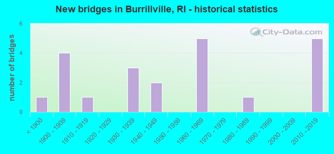
- New bridges - historical statistics
- 1Before 1900
- 41900-1909
- 11910-1919
- 31930-1939
- 21940-1949
- 51960-1969
- 11980-1989
- 52010-2019

- Reconstructed bridges - Historical Statistics
- 11910-1919
- 11920-1929
- 01930-1939
- 01940-1949
- 01950-1959
- 01960-1969
- 01970-1979
- 01980-1989
- 31990-1999
- 22000-2009


- Bridge Condition - Deck
- 6.7%Excellent
- 26.7%Very good
- 20.0%Good
- 40.0%Satisfactory
- 6.7%Poor

- Bridge Condition - Superstructure
- 4.5%Excellent
- 4.5%Very good
- 36.4%Good
- 9.1%Satisfactory
- 22.7%Fair
- 18.2%Poor
- 4.5%Serious

- Bridge Condition - Substructure
- 13.6%Very good
- 22.7%Good
- 9.1%Satisfactory
- 22.7%Fair
- 27.3%Poor
- 4.5%Serious

- Bridge Condition - Channel
- 9.5%Very good
- 38.1%Good
- 38.1%Satisfactory
- 9.5%Fair
- 4.8%Poor
Find on map >> Show street view
Structure Number: 105, Location: 0.6 Mi N of JCT RI 102 (Lat: 41.956611, Lng: -71.649358), Route carried "on" structure: City street , Year Built: 1918, Status: Posted for load, Structure Length: 1.83m (6.00ft), Average Daily Traffic: 770 (year 2021), Truck Traffic: 8%, Average Future Daily Traffic: 847 (year 2041), Design Load: HS 20, Features Intersected: PASCOAG RIVER, Facility Carried by Structure: VICTORY HWY
Minimum Vertical Clearance: 30+ m (98+ ft), Kilometerpoint: 3.676, Lanes on structure: 2, Owner: State Highway Agency, Approaching Roadway Width: 6.3m (20.7ft), Material/Design: Concrete, Design/Construction: Arch - Deck, Number Of Spans In Main Unit: 1, Length of Maximum Span: 18.3m (60.0ft), Curb or Sidewalk Widths: Left: 0.0m, Right: 1.4m (4.6ft), Curb-To-Curb Width: 6.3m (20.7ft), Out-to-Out Width: 8.5m (27.9ft)
Condition: Superstructure: Fair, Substructure: Fair, Channel: Satisfactory, Operating Rating: 26.9 metric tons, Method Used To Determine Operating Rating: Load and Resistance Factor Rating (LRFR) rating reported by rating factor(RF) method using HL-93 loadings, Inventory Rating: 20.7 metric tons, Method Used To Determine Inventory Rating: Load and Resistance Factor Rating (LRFR) rating reported by rating factor(RF) method using HL-93 loadings, Structural Evaluation: Somewhat better than minimum adequacy, Deck Geometry: High priority of corrective action, Waterway Adequacy: Equal to present desirable criteria, Approach Roadway Alignment: Equal to present minimum criteria, Bridge Posting: Required (Relationship of Operating Rating to Maximum Legal Load: 20.0 - 29.9% below), Length Of Structure Improvement: 1.86m (6.10ft), Designated Inspection Frequency: Every 24 months, Other Special Inspection Frequency: Every 12 months, Inspection Date: November 2021, Other Special Inspection Date: November 2021, Bridge Improvement Cost: $896,000, Roadway Improvement Cost: $90,000, Total Project Cost: $1,344,000
Find on map >> Show street view
Structure Number: 111, Location: 0.3 Mi S of JCT RI 102 (Lat: 41.978197, Lng: -71.615044), Route carried "on" structure: State highway 7, Year Built: 1907, Year Reconstructed: 1923, Status: Open, Structure Length: 1.52m (4.99ft), Average Daily Traffic: 5,454 (year 2014), Truck Traffic: 3%, Average Future Daily Traffic: 6,545 (year 2036), Design Load: HS 20, Features Intersected: BRANCH RIVER
Minimum Vertical Clearance: 30+ m (98+ ft), Kilometerpoint: 23.627, Lanes on structure: 2, Owner: State Highway Agency, Approaching Roadway Width: 6.8m (22.3ft), Material/Design: Masonry, Design/Construction: Arch - Deck, Number Of Spans In Main Unit: 1, Length of Maximum Span: 15.2m (49.9ft), Curb or Sidewalk Widths: Left: 0.5m (1.6ft), Right: 0.5m (1.6ft), Curb-To-Curb Width: 6.8m (22.3ft), Out-to-Out Width: 8.5m (27.9ft)
Condition: Superstructure: Fair, Substructure: Poor, Channel: Fair, Structural Evaluation: Meets minimum limits, Deck Geometry: High priority of replacement, Waterway Adequacy: Equal to present desirable criteria, Approach Roadway Alignment: Meets minimum limits, Length Of Structure Improvement: 1.52m (4.99ft), Designated Inspection Frequency: Every 24 months, Other Special Inspection Frequency: Every 3 months, Inspection Date: January 2022, Other Special Inspection Date: January 2022, Bridge Improvement Cost: $697,000, Roadway Improvement Cost: $70,000, Total Project Cost: $1,046,000
Find on map >> Show street view
Structure Number: 112, Location: 0.9 Mi N of JCT RI 107 (Lat: 41.973711, Lng: -71.631936), Route carried "on" structure: Alternate City street , Year Built: 1987, Status: Posted for load, Structure Length: 2.12m (6.96ft), Average Daily Traffic: 3,300 (year 2021), Truck Traffic: 7%, Average Future Daily Traffic: 3,630 (year 2041), Design Load: HS 20, Features Intersected: BRANCH RIVER, Facility Carried by Structure: VICTORY HWY
Minimum Vertical Clearance: 30+ m (98+ ft), Kilometerpoint: 6.127, Lanes on structure: 2, Owner: State Highway Agency, Approaching Roadway Width: 9.1m (29.9ft), Material/Design: Prestressed concrete, Design/Construction: Box Beam or Girders - Multiple, Number Of Spans In Main Unit: 1, Length of Maximum Span: 20.0m (65.6ft), Curb or Sidewalk Widths: Left: 1.5m (4.9ft), Right: 1.5m (4.9ft), Curb-To-Curb Width: 9.1m (29.9ft), Out-to-Out Width: 12.8m (42.0ft)
Condition: Deck: Satisfactory, Superstructure: Serious, Substructure: Good, Channel: Satisfactory, Operating Rating: 23.0 metric tons, Method Used To Determine Operating Rating: Load and Resistance Factor Rating (LRFR) rating reported by rating factor(RF) method using HL-93 loadings, Inventory Rating: 17.8 metric tons, Method Used To Determine Inventory Rating: Load and Resistance Factor Rating (LRFR) rating reported by rating factor(RF) method using HL-93 loadings, Structural Evaluation: High priority of corrective action, Deck Geometry: Meets minimum limits, Waterway Adequacy: Equal to present desirable criteria, Approach Roadway Alignment: Somewhat better than minimum adequacy, Bridge Posting: Required (Relationship of Operating Rating to Maximum Legal Load: 30.0 - 39.9% below), Length Of Structure Improvement: 2.04m (6.69ft), Designated Inspection Frequency: Every 24 months, Other Special Inspection Frequency: Every 12 months, Inspection Date: July 2020, Other Special Inspection Date: July 2021, Bridge Improvement Cost: $543,000, Roadway Improvement Cost: $54,000, Total Project Cost: $815,000, Deck Structure Type: Concrete Precast Panels, Wearing Surface/Protective System: Wearing Surface: Bituminous, Membrane: Other
Find on map >> Show street view
Structure Number: 198, Location: 0.1 Mi W of Main St (Lat: 41.955719, Lng: -71.703122), Route carried "on" structure: State highway 100, Year Built: 1865, Year Reconstructed: 1925, Status: Open, Structure Length: 1.04m (3.41ft), Average Daily Traffic: 5,800 (year 2021), Truck Traffic: 7%, Average Future Daily Traffic: 6,380 (year 2041), Design Load: HS 20, Features Intersected: PASCOAG RIVER, Facility Carried by Structure: HIGH ST
Minimum Vertical Clearance: 30+ m (98+ ft), Kilometerpoint: 5.222, Lanes on structure: 2, Owner: State Highway Agency, Approaching Roadway Width: 8.2m (26.9ft), Material/Design: Masonry, Design/Construction: Arch - Deck, Number Of Spans In Main Unit: 2, Length of Maximum Span: 4.3m (14.1ft), Curb or Sidewalk Widths: Left: 1.5m (4.9ft), Right: 1.5m (4.9ft), Curb-To-Curb Width: 8.2m (26.9ft), Out-to-Out Width: 12.3m (40.4ft)
Condition: Superstructure: Poor, Substructure: Poor, Channel: Satisfactory, Operating Rating: 74.2 metric tons, Method Used To Determine Operating Rating: Allowable Stress (AS), Inventory Rating: 44.5 metric tons, Method Used To Determine Inventory Rating: Allowable Stress (AS), Structural Evaluation: Meets minimum limits, Deck Geometry: High priority of replacement, Waterway Adequacy: Equal to present minimum criteria, Approach Roadway Alignment: Equal to present minimum criteria, Length Of Structure Improvement: 1.04m (3.41ft), Designated Inspection Frequency: Every 24 months, Other Special Inspection Frequency: Every 12 months, Inspection Date: September 2021, Other Special Inspection Date: September 2021, Bridge Improvement Cost: $650,000, Roadway Improvement Cost: $65,000, Total Project Cost: $975,000
Find on map >> Show street view
Structure Number: 222, Location: 0.1 Mi E of JCT RI 100 (Lat: 41.965767, Lng: -71.712214), Route carried "on" structure: City street , Year Built: 1946, Status: Open, Structure Length: 0.79m (2.59ft), Average Daily Traffic: 300 (year 2021), Truck Traffic: 7%, Average Future Daily Traffic: 330 (year 2041), Design Load: HS 20, Features Intersected: CLEAR RIVER, Facility Carried by Structure: LAUREL RIDGE
Minimum Vertical Clearance: 30+ m (98+ ft), Kilometerpoint: 0.154, Lanes on structure: 2, Owner: Town or Township Highway Agency, Approaching Roadway Width: 6.1m (20.0ft), Material/Design: Steel, Design/Construction: Stringer/Multi-beam, Number Of Spans In Main Unit: 1, Length of Maximum Span: 6.7m (22.0ft), Curb-To-Curb Width: 6.2m (20.3ft), Out-to-Out Width: 6.9m (22.6ft)
Condition: Deck: Satisfactory, Superstructure: Satisfactory, Substructure: Poor, Channel: Fair, Operating Rating: 39.5 metric tons, Method Used To Determine Operating Rating: Load and Resistance Factor Rating (LRFR) rating reported by rating factor(RF) method using HL-93 loadings, Inventory Rating: 30.5 metric tons, Method Used To Determine Inventory Rating: Load and Resistance Factor Rating (LRFR) rating reported by rating factor(RF) method using HL-93 loadings, Structural Evaluation: Meets minimum limits, Deck Geometry: Meets minimum limits, Waterway Adequacy: Somewhat better than minimum adequacy, Approach Roadway Alignment: Better than present minimum criteria, Length Of Structure Improvement: 0.79m (2.59ft), Designated Inspection Frequency: Every 24 months, Other Special Inspection Frequency: Every 12 months, Inspection Date: April 2020, Other Special Inspection Date: April 2021, Bridge Improvement Cost: $348,000, Roadway Improvement Cost: $35,000, Total Project Cost: $522,000, Deck Structure Type: Concrete Cast-file-Place, Wearing Surface/Protective System: Wearing Surface: Bituminous
Find on map >> Show street view
Structure Number: 306, Location: 1.7 Mi W of JCT RI 102 (Lat: 41.965444, Lng: -71.674514), Route carried "on" structure: Alternate State highway 107, Year Built: 1902, Status: Posted for load, Structure Length: 1.50m (4.92ft), Average Daily Traffic: 8,750 (year 2021), Truck Traffic: 7%, Average Future Daily Traffic: 9,625 (year 2041), Design Load: HS 20, Features Intersected: PASCOAG RIVER
Minimum Vertical Clearance: 30+ m (98+ ft), Kilometerpoint: 3.241, Lanes on structure: 2, Owner: State Highway Agency, Approaching Roadway Width: 7.7m (25.3ft), Material/Design: Masonry, Design/Construction: Arch - Deck, Number Of Spans In Main Unit: 1, Length of Maximum Span: 15.0m (49.2ft), Curb or Sidewalk Widths: Left: 0.0m, Right: 1.8m (5.9ft), Curb-To-Curb Width: 7.7m (25.3ft), Out-to-Out Width: 10.6m (34.8ft)
Condition: Superstructure: Poor, Substructure: Poor, Channel: Good, Operating Rating: 63.6 metric tons, Method Used To Determine Operating Rating: Allowable Stress (AS), Inventory Rating: 38.1 metric tons, Method Used To Determine Inventory Rating: Load and Resistance Factor (LRFR), Structural Evaluation: Meets minimum limits, Deck Geometry: High priority of replacement, Waterway Adequacy: Equal to present desirable criteria, Approach Roadway Alignment: Better than present minimum criteria, Bridge Posting: Required (Relationship of Operating Rating to Maximum Legal Load: > 39.9% below), Length Of Structure Improvement: 3.41m (11.19ft), Designated Inspection Frequency: Every 24 months, Other Special Inspection Frequency: Every 12 months, Inspection Date: September 2021, Other Special Inspection Date: September 2021, Bridge Improvement Cost: $3,981,000, Roadway Improvement Cost: $398,000, Total Project Cost: $5,972,000
Find on map >> Show street view
Structure Number: 3075, Location: 0.4 Mi N of JCT RI 107 (Lat: 41.970931, Lng: -71.678439), Route carried "on" structure: State highway 98, Year Built: 2016, Status: Open, Structure Length: 3.22m (10.56ft), Average Daily Traffic: 1,750 (year 2019), Truck Traffic: 11%, Average Future Daily Traffic: 1,925 (year 2041), Design Load: Greater than HL93, Features Intersected: NIPMUC RIVER
Minimum Vertical Clearance: 30+ m (98+ ft), Kilometerpoint: 4.999, Lanes on structure: 2, Owner: State Highway Agency, Approaching Roadway Width: 9.1m (29.9ft), Skew: 1 degrees, Material/Design: Prestressed concrete, Design/Construction: Box Beam or Girders - Multiple, Number Of Spans In Main Unit: 1, Length of Maximum Span: 31.6m (103.7ft), Curb or Sidewalk Widths: Left: 1.7m (5.6ft), Right: 0.0m, Curb-To-Curb Width: 9.1m (29.9ft), Out-to-Out Width: 12.1m (39.7ft)
Condition: Deck: Very good, Superstructure: Good, Substructure: Very good, Channel: Poor, Operating Rating: 85.2 metric tons, Method Used To Determine Operating Rating: Load and Resistance Factor Rating (LRFR) rating reported by rating factor(RF) method using HL-93 loadings, Inventory Rating: 56.7 metric tons, Method Used To Determine Inventory Rating: Load and Resistance Factor Rating (LRFR) rating reported by rating factor(RF) method using HL-93 loadings, Structural Evaluation: Better than present minimum criteria, Deck Geometry: Somewhat better than minimum adequacy, Waterway Adequacy: Better than present minimum criteria, Approach Roadway Alignment: Equal to present minimum criteria, Length Of Structure Improvement: 2.35m (7.71ft), Designated Inspection Frequency: Every 24 months, Inspection Date: December 2020, Bridge Improvement Cost: $1,143,000, Roadway Improvement Cost: $114,000, Total Project Cost: $1,715,000, Deck Structure Type: Concrete Precast Panels, Wearing Surface/Protective System: Wearing Surface: Bituminous, Membrane: Preformed Fabric, Deck Protection: Galvanized Reinforcing
Find on map >> Show street view
Structure Number: 308, Location: 0.4 Mi W of JCT RI 98 (Lat: 41.968703, Lng: -71.685714), Route carried "on" structure: State highway 107, Year Built: 1947, Year Reconstructed: 2009, Status: Open, Structure Length: 2.23m (7.32ft), Average Daily Traffic: 7,650 (year 2021), Truck Traffic: 4%, Average Future Daily Traffic: 8,415 (year 2041), Design Load: HS 20, Features Intersected: PASCOAG RIVER
Minimum Vertical Clearance: 30+ m (98+ ft), Kilometerpoint: 2.155, Lanes on structure: 2, Owner: State Highway Agency, Approaching Roadway Width: 13.4m (44.0ft), Skew: 4 degrees, Material/Design: Concrete continuous, Design/Construction: Slab, Number Of Spans In Main Unit: 3, Length of Maximum Span: 7.7m (25.3ft), Curb or Sidewalk Widths: Left: 1.5m (4.9ft), Right: 1.5m (4.9ft), Curb-To-Curb Width: 13.4m (44.0ft), Out-to-Out Width: 17.3m (56.8ft)
Condition: Deck: Good, Superstructure: Good, Substructure: Good, Channel: Good, Operating Rating: 60.3 metric tons, Method Used To Determine Operating Rating: Load and Resistance Factor Rating (LRFR) rating reported by rating factor(RF) method using HL-93 loadings, Inventory Rating: 46.7 metric tons, Method Used To Determine Inventory Rating: Load and Resistance Factor Rating (LRFR) rating reported by rating factor(RF) method using HL-93 loadings, Structural Evaluation: Better than present minimum criteria, Deck Geometry: Equal to present minimum criteria, Waterway Adequacy: Equal to present desirable criteria, Approach Roadway Alignment: Better than present minimum criteria, Length Of Structure Improvement: 2.44m (8.01ft), Designated Inspection Frequency: Every 24 months, Inspection Date: November 2020, Bridge Improvement Cost: $1,380,000, Roadway Improvement Cost: $138,000, Total Project Cost: $2,070,000, Deck Structure Type: Concrete Cast-file-Place, Wearing Surface/Protective System: Wearing Surface: Bituminous, Membrane: Other
Find on map >> Show street view
Structure Number: 31, Location: 1.0 Mi N of JCT RI 100 (Lat: 41.965503, Lng: -71.692814), Route carried "on" structure: State highway 107, Year Built: 1933, Year Reconstructed: 1997, Status: Open, Structure Length: 1.72m (5.64ft), Average Daily Traffic: 14,200 (year 2021), Truck Traffic: 9%, Average Future Daily Traffic: 15,620 (year 2041), Design Load: HS 25 or greater, Features Intersected: PASCOAG RIVER
Minimum Vertical Clearance: 30+ m (98+ ft), Kilometerpoint: 1.447, Lanes on structure: 2, Owner: State Highway Agency, Approaching Roadway Width: 9.8m (32.2ft), Skew: 4 degrees, Material/Design: Prestressed concrete, Design/Construction: Box Beam or Girders - Multiple, Number Of Spans In Main Unit: 1, Length of Maximum Span: 15.5m (50.9ft), Curb or Sidewalk Widths: Left: 1.5m (4.9ft), Right: 1.5m (4.9ft), Curb-To-Curb Width: 9.8m (32.2ft), Out-to-Out Width: 13.4m (44.0ft)
Condition: Deck: Satisfactory, Superstructure: Fair, Substructure: Satisfactory, Channel: Satisfactory, Operating Rating: 59.0 metric tons, Method Used To Determine Operating Rating: Load and Resistance Factor Rating (LRFR) rating reported by rating factor(RF) method using HL-93 loadings, Inventory Rating: 45.4 metric tons, Method Used To Determine Inventory Rating: Load and Resistance Factor Rating (LRFR) rating reported by rating factor(RF) method using HL-93 loadings, Structural Evaluation: Somewhat better than minimum adequacy, Deck Geometry: Meets minimum limits, Waterway Adequacy: Equal to present desirable criteria, Approach Roadway Alignment: Somewhat better than minimum adequacy, Length Of Structure Improvement: 1.46m (4.79ft), Designated Inspection Frequency: Every 24 months, Inspection Date: April 2020, Bridge Improvement Cost: $1,934,000, Roadway Improvement Cost: $193,000, Total Project Cost: $2,901,000, Deck Structure Type: Concrete Precast Panels, Wearing Surface/Protective System: Wearing Surface: Bituminous, Membrane: Other
Find on map >> Show street view
Structure Number: 315, Location: 150 ft W of Main St (Lat: 41.957139, Lng: -71.701864), Route carried "on" structure: City street , Year Built: 1938, Status: Open, Structure Length: 0.76m (2.49ft), Average Daily Traffic: 4,600 (year 2021), Truck Traffic: 5%, Average Future Daily Traffic: 5,060 (year 2041), Design Load: HS 20, Features Intersected: PASCOAG RIVER, Facility Carried by Structure: BRIDGEWAY RD
Minimum Vertical Clearance: 30+ m (98+ ft), Kilometerpoint: 0.056, Lanes on structure: 2, Owner: Town or Township Highway Agency, Approaching Roadway Width: 12.2m (40.0ft), Material/Design: Concrete, Design/Construction: Arch - Deck, Number Of Spans In Main Unit: 1, Length of Maximum Span: 7.6m (24.9ft), Curb or Sidewalk Widths: Left: 1.8m (5.9ft), Right: 1.8m (5.9ft), Curb-To-Curb Width: 10.4m (34.1ft), Out-to-Out Width: 15.2m (49.9ft)
Condition: Superstructure: Good, Substructure: Fair, Channel: Satisfactory, Operating Rating: 97.2 metric tons, Method Used To Determine Operating Rating: Load and Resistance Factor Rating (LRFR) rating reported by rating factor(RF) method using HL-93 loadings, Inventory Rating: 97.2 metric tons, Method Used To Determine Inventory Rating: Load and Resistance Factor Rating (LRFR) rating reported by rating factor(RF) method using HL-93 loadings, Structural Evaluation: Somewhat better than minimum adequacy, Deck Geometry: Somewhat better than minimum adequacy, Waterway Adequacy: Equal to present desirable criteria, Approach Roadway Alignment: Equal to present minimum criteria, Length Of Structure Improvement: 0.76m (2.49ft), Designated Inspection Frequency: Every 24 months, Inspection Date: April 2020, Bridge Improvement Cost: $150,000, Roadway Improvement Cost: $15,000, Total Project Cost: $225,000
Find on map >> Show street view
Structure Number: 337, Location: 0.1 Mi E of Gazza Rd (Lat: 41.948550, Lng: -71.644969), Route carried "on" structure: State highway 107, Year Built: 1903, Year Reconstructed: 2004, Status: Open, Structure Length: 1.00m (3.28ft), Average Daily Traffic: 2,700 (year 2021), Truck Traffic: 9%, Average Future Daily Traffic: 2,970 (year 2041), Design Load: HS 25 or greater, Features Intersected: CHEPACHET RIVER
Minimum Vertical Clearance: 30+ m (98+ ft), Kilometerpoint: 0.208, Lanes on structure: 2, Owner: Town or Township Highway Agency, Approaching Roadway Width: 9.1m (29.9ft), Material/Design: Concrete, Design/Construction: Frame, Number Of Spans In Main Unit: 1, Length of Maximum Span: 9.1m (29.9ft), Curb or Sidewalk Widths: Left: 1.5m (4.9ft), Right: 1.5m (4.9ft), Curb-To-Curb Width: 9.1m (29.9ft), Out-to-Out Width: 13.1m (43.0ft)
Condition: Deck: Good, Superstructure: Good, Substructure: Satisfactory, Channel: Good, Operating Rating: 89.4 metric tons, Method Used To Determine Operating Rating: Load and Resistance Factor Rating (LRFR) rating reported by rating factor(RF) method using HL-93 loadings, Inventory Rating: 69.0 metric tons, Method Used To Determine Inventory Rating: Load and Resistance Factor Rating (LRFR) rating reported by rating factor(RF) method using HL-93 loadings, Structural Evaluation: Equal to present minimum criteria, Deck Geometry: Meets minimum limits, Waterway Adequacy: Equal to present minimum criteria, Approach Roadway Alignment: Equal to present desirable criteria, Length Of Structure Improvement: 1.07m (3.51ft), Designated Inspection Frequency: Every 24 months, Underwater Inspection Frequency: Every 48 months, Inspection Date: March 2022, Underwater Inspection Date: March 2018, Bridge Improvement Cost: $611,000, Roadway Improvement Cost: $61,000, Total Project Cost: $917,000, Deck Structure Type: Concrete Precast Panels, Wearing Surface/Protective System: Wearing Surface: Bituminous
Find on map >> Show street view
Structure Number: 353, Location: 0.5 Mi S of JCT MAIN ST (Lat: 41.942208, Lng: -71.647517), Route carried "on" structure: City street , Year Built: 1965, Year Reconstructed: 2008, Status: Open, Structure Length: 1.19m (3.90ft), Average Daily Traffic: 305 (year 2021), Truck Traffic: 7%, Average Future Daily Traffic: 336 (year 2041), Design Load: HS 20, Features Intersected: CHEPACHET RIVER, Facility Carried by Structure: GAZZA RD
Minimum Vertical Clearance: 30+ m (98+ ft), Kilometerpoint: 1.493, Lanes on structure: 2, Owner: Town or Township Highway Agency, Approaching Roadway Width: 8.2m (26.9ft), Skew: 2 degrees, Material/Design: Prestressed concrete, Design/Construction: Slab, Number Of Spans In Main Unit: 1, Length of Maximum Span: 11.1m (36.4ft), Curb-To-Curb Width: 8.2m (26.9ft), Out-to-Out Width: 9.1m (29.9ft)
Condition: Deck: Good, Superstructure: Good, Substructure: Fair, Channel: Satisfactory, Operating Rating: 49.6 metric tons, Method Used To Determine Operating Rating: Load and Resistance Factor Rating (LRFR) rating reported by rating factor(RF) method using HL-93 loadings, Inventory Rating: 38.6 metric tons, Method Used To Determine Inventory Rating: Load and Resistance Factor Rating (LRFR) rating reported by rating factor(RF) method using HL-93 loadings, Structural Evaluation: Somewhat better than minimum adequacy, Deck Geometry: Somewhat better than minimum adequacy, Waterway Adequacy: Equal to present desirable criteria, Approach Roadway Alignment: Equal to present minimum criteria, Length Of Structure Improvement: 1.19m (3.90ft), Designated Inspection Frequency: Every 24 months, Inspection Date: March 2020, Bridge Improvement Cost: $707,000, Roadway Improvement Cost: $71,000, Total Project Cost: $1,061,000, Deck Structure Type: Concrete Precast Panels, Wearing Surface/Protective System: Wearing Surface: Bituminous
Find on map >> Show street view
Structure Number: 3545, Location: 0.1 Mi E of Chapel St (Lat: 41.967431, Lng: -71.689406), Route carried "on" structure: City street , Year Built: 2018, Status: Open, Structure Length: 1.58m (5.18ft), Average Daily Traffic: 184 (year 2021), Truck Traffic: 5%, Average Future Daily Traffic: 202 (year 2041), Design Load: HL 93, Features Intersected: PASCOAG RIVER, Facility Carried by Structure: RAILROAD AVE
Minimum Vertical Clearance: 30+ m (98+ ft), Kilometerpoint: 0.526, Lanes on structure: 2, Owner: Town or Township Highway Agency, Approaching Roadway Width: 7.3m (24.0ft), Design/Construction: Arch - Deck, Number Of Spans In Main Unit: 1, Length of Maximum Span: 11.6m (38.1ft), Curb or Sidewalk Widths: Left: 0.0m, Right: 1.8m (5.9ft), Curb-To-Curb Width: 7.3m (24.0ft), Out-to-Out Width: 10.2m (33.5ft)
Condition: Deck: Very good, Superstructure: Very good, Substructure: Very good, Channel: Very good, Operating Rating: 59.6 metric tons, Method Used To Determine Operating Rating: Load and Resistance Factor Rating (LRFR) rating reported by rating factor(RF) method using HL-93 loadings, Inventory Rating: 46.0 metric tons, Method Used To Determine Inventory Rating: Load and Resistance Factor Rating (LRFR) rating reported by rating factor(RF) method using HL-93 loadings, Structural Evaluation: Equal to present desirable criteria, Deck Geometry: Somewhat better than minimum adequacy, Waterway Adequacy: Equal to present desirable criteria, Approach Roadway Alignment: Better than present minimum criteria, Length Of Structure Improvement: 0.91m (2.99ft), Designated Inspection Frequency: Every 24 months, Inspection Date: October 2020, Bridge Improvement Cost: $185,000, Roadway Improvement Cost: $19,000, Total Project Cost: $278,000, Deck Structure Type: Other, Wearing Surface/Protective System: Wearing Surface: Bituminous
Find on map >> Show street view
Structure Number: 355, Location: 0.2 Mi N of JCT RI 100 (Lat: 41.967911, Lng: -71.716433), Route carried "on" structure: City street , Year Built: 2010, Status: Open, Structure Length: 1.29m (4.23ft), Average Daily Traffic: 62 (year 2021), Truck Traffic: 22%, Average Future Daily Traffic: 68 (year 2041), Design Load: HS 20, Features Intersected: CLEAR RIVER, Facility Carried by Structure: WARNER LANE
Minimum Vertical Clearance: 30+ m (98+ ft), Kilometerpoint: 0.214, Lanes on structure: 2, Owner: Town or Township Highway Agency, Approaching Roadway Width: 7.6m (24.9ft), Material/Design: Prestressed concrete, Design/Construction: Box Beam or Girders - Multiple, Number Of Spans In Main Unit: 1, Length of Maximum Span: 11.6m (38.1ft), Curb-To-Curb Width: 7.6m (24.9ft), Out-to-Out Width: 8.5m (27.9ft)
Condition: Deck: Very good, Superstructure: Good, Substructure: Good, Channel: Good, Operating Rating: 55.5 metric tons, Method Used To Determine Operating Rating: Load and Resistance Factor (LRFR), Inventory Rating: 38.6 metric tons, Method Used To Determine Inventory Rating: Load and Resistance Factor (LRFR), Structural Evaluation: Better than present minimum criteria, Deck Geometry: Equal to present minimum criteria, Waterway Adequacy: Equal to present desirable criteria, Approach Roadway Alignment: Equal to present minimum criteria, Length Of Structure Improvement: 0.91m (2.99ft), Designated Inspection Frequency: Every 24 months, Inspection Date: October 2021, Bridge Improvement Cost: $357,000, Roadway Improvement Cost: $36,000, Total Project Cost: $536,000, Deck Structure Type: Concrete Precast Panels, Wearing Surface/Protective System: Wearing Surface: Bituminous, Membrane: Preformed Fabric
Find on map >> Show street view
Structure Number: 356, Location: 0.3 Mi S of JCT RI 7 (Lat: 41.964639, Lng: -71.598383), Route carried "on" structure: City street , Year Built: 1935, Year Reconstructed: 2004, Status: Open, Structure Length: 1.10m (3.61ft), Average Daily Traffic: 1,095 (year 2021), Truck Traffic: 11%, Average Future Daily Traffic: 1,205 (year 2041), Design Load: HS 20, Features Intersected: TARKILN POND, Facility Carried by Structure: TARKILN RD
Minimum Vertical Clearance: 30+ m (98+ ft), Kilometerpoint: 5.398, Lanes on structure: 2, Owner: Town or Township Highway Agency, Approaching Roadway Width: 8.4m (27.6ft), Material/Design: Concrete, Design/Construction: Arch - Deck, Number Of Spans In Main Unit: 1, Length of Maximum Span: 11.0m (36.1ft), Curb-To-Curb Width: 8.4m (27.6ft), Out-to-Out Width: 9.1m (29.9ft)
Condition: Superstructure: Good, Substructure: Good, Channel: Good, Operating Rating: 60.9 metric tons, Method Used To Determine Operating Rating: Load and Resistance Factor Rating (LRFR) rating reported by rating factor(RF) method using HL-93 loadings, Inventory Rating: 46.7 metric tons, Method Used To Determine Inventory Rating: Load and Resistance Factor Rating (LRFR) rating reported by rating factor(RF) method using HL-93 loadings, Structural Evaluation: Better than present minimum criteria, Deck Geometry: Meets minimum limits, Waterway Adequacy: Equal to present desirable criteria, Approach Roadway Alignment: Meets minimum limits, Length Of Structure Improvement: 1.19m (3.90ft), Designated Inspection Frequency: Every 24 months, Inspection Date: March 2020, Bridge Improvement Cost: $669,000, Roadway Improvement Cost: $67,000, Total Project Cost: $1,004,000
Find on map >> Show street view
Structure Number: 378, Location: 0.3 Mi N of JCT RI 98 (Lat: 41.970122, Lng: -71.684947), Route carried "on" structure: State highway 96, Year Built: 2010, Status: Open, Structure Length: 2.37m (7.78ft), Average Daily Traffic: 3,181 (year 2021), Truck Traffic: 14%, Average Future Daily Traffic: 3,499 (year 2041), Design Load: HL 93, Features Intersected: PASCOAG RIVER
Minimum Vertical Clearance: 30+ m (98+ ft), Kilometerpoint: 0.578, Lanes on structure: 2, Owner: State Highway Agency, Approaching Roadway Width: 8.2m (26.9ft), Skew: 2 degrees, Material/Design: Prestressed concrete, Design/Construction: Box Beam or Girders - Multiple, Number Of Spans In Main Unit: 1, Length of Maximum Span: 22.0m (72.2ft), Curb or Sidewalk Widths: Left: 1.4m (4.6ft), Right: 1.5m (4.9ft), Curb-To-Curb Width: 8.2m (26.9ft), Out-to-Out Width: 14.6m (47.9ft)
Condition: Deck: Very good, Superstructure: Good, Substructure: Good, Channel: Good, Operating Rating: 42.4 metric tons, Method Used To Determine Operating Rating: Load and Resistance Factor Rating (LRFR) rating reported by rating factor(RF) method using HL-93 loadings, Inventory Rating: 33.4 metric tons, Method Used To Determine Inventory Rating: Load and Resistance Factor Rating (LRFR) rating reported by rating factor(RF) method using HL-93 loadings, Structural Evaluation: Better than present minimum criteria, Deck Geometry: High priority of corrective action, Waterway Adequacy: Equal to present desirable criteria, Approach Roadway Alignment: Equal to present desirable criteria, Length Of Structure Improvement: 1.77m (5.81ft), Designated Inspection Frequency: Every 24 months, Inspection Date: July 2020, Bridge Improvement Cost: $477,000, Roadway Improvement Cost: $48,000, Total Project Cost: $716,000, Wearing Surface/Protective System: Wearing Surface: Bituminous, Membrane: Epoxy
Find on map >> Show street view
Structure Number: 4125, Location: 0.1 Mi N of Laurel Hll Rd (Lat: 41.967150, Lng: -71.708858), Route carried "on" structure: City street , Year Built: 2017, Status: Open, Structure Length: 1.33m (4.36ft), Average Daily Traffic: 454 (year 2021), Truck Traffic: 7%, Average Future Daily Traffic: 499 (year 2041), Design Load: HL 93, Features Intersected: CLEAR RIVER, Facility Carried by Structure: NORTH ROAD
Minimum Vertical Clearance: 30+ m (98+ ft), Kilometerpoint: 0.113, Lanes on structure: 2, Owner: Town or Township Highway Agency, Approaching Roadway Width: 8.0m (26.2ft), Material/Design: Prestressed concrete, Design/Construction: Box Beam or Girders - Multiple, Number Of Spans In Main Unit: 1, Length of Maximum Span: 12.4m (40.7ft), Curb or Sidewalk Widths: Left: 0.1m (0.3ft), Right: 0.1m (0.3ft), Curb-To-Curb Width: 8.0m (26.2ft), Out-to-Out Width: 9.2m (30.2ft)
Condition: Deck: Excellent, Superstructure: Excellent, Substructure: Very good, Channel: Very good, Operating Rating: 97.2 metric tons, Method Used To Determine Operating Rating: Load and Resistance Factor Rating (LRFR) rating reported by rating factor(RF) method using HL-93 loadings, Inventory Rating: 76.8 metric tons, Method Used To Determine Inventory Rating: Load and Resistance Factor Rating (LRFR) rating reported by rating factor(RF) method using HL-93 loadings, Structural Evaluation: Equal to present desirable criteria, Deck Geometry: Somewhat better than minimum adequacy, Waterway Adequacy: Equal to present desirable criteria, Approach Roadway Alignment: Equal to present desirable criteria, Designated Inspection Frequency: Every 24 months, Inspection Date: April 2020, Deck Structure Type: Concrete Cast-file-Place, Wearing Surface/Protective System: Wearing Surface: Bituminous, Membrane: Preformed Fabric, Deck Protection: Galvanized Reinforcing
Find on map >> Show street view
Structure Number: 512, Location: 0.1 Mi N of JCT RI 100 (Lat: 41.956267, Lng: -71.702519), Route carried "on" structure: City street , Year Built: 1906, Status: Open, Structure Length: 0.73m (2.40ft), Average Daily Traffic: 3,600 (year 2021), Truck Traffic: 8%, Average Future Daily Traffic: 3,960 (year 2041), Design Load: HS 20, Features Intersected: PASCOAG RIVER, Facility Carried by Structure: SAYLES Avenue
Minimum Vertical Clearance: 30+ m (98+ ft), Kilometerpoint: 0.212, Lanes on structure: 2, Owner: Town or Township Highway Agency, Approaching Roadway Width: 8.4m (27.6ft), Material/Design: Masonry, Design/Construction: Arch - Deck, Number Of Spans In Main Unit: 1, Length of Maximum Span: 7.3m (24.0ft), Curb or Sidewalk Widths: Left: 0.0m, Right: 1.6m (5.2ft), Curb-To-Curb Width: 8.4m (27.6ft), Out-to-Out Width: 10.9m (35.8ft)
Condition: Superstructure: Satisfactory, Substructure: Fair, Channel: Satisfactory, Operating Rating: 38.5 metric tons, Method Used To Determine Operating Rating: Allowable Stress (AS), Inventory Rating: 23.1 metric tons, Method Used To Determine Inventory Rating: Allowable Stress (AS), Structural Evaluation: Somewhat better than minimum adequacy, Deck Geometry: High priority of corrective action, Waterway Adequacy: Equal to present desirable criteria, Approach Roadway Alignment: Better than present minimum criteria, Length Of Structure Improvement: 0.73m (2.40ft), Designated Inspection Frequency: Every 24 months, Inspection Date: July 2021, Bridge Improvement Cost: $154,000, Roadway Improvement Cost: $15,000, Total Project Cost: $231,000
Find on map >> Show street view
Structure Number: 67, Location: 2.3 Mi S of JCT RI 7 (Lat: 41.960436, Lng: -71.650011), Route carried "on" structure: Alternate State highway 102, Year Built: 1965, Status: Open, Structure Length: 3.25m (10.66ft), Average Daily Traffic: 9,300 (year 2021), Truck Traffic: 14%, Average Future Daily Traffic: 10,230 (year 2041), Design Load: HS 20, Features Intersected: PASCOAG RIVER
Minimum Vertical Clearance: 30+ m (98+ ft), Kilometerpoint: 63.540, Lanes on structure: 3, Base Highway Network: Yes, Owner: State Highway Agency, Approaching Roadway Width: 13.4m (44.0ft), Skew: 3 degrees, Material/Design: Steel, Design/Construction: Stringer/Multi-beam, Number Of Spans In Main Unit: 1, Length of Maximum Span: 30.5m (100.1ft), Curb-To-Curb Width: 13.4m (44.0ft), Out-to-Out Width: 15.4m (50.5ft)
Condition: Deck: Satisfactory, Superstructure: Fair, Substructure: Fair, Channel: Good, Operating Rating: 31.1 metric tons, Method Used To Determine Operating Rating: Load and Resistance Factor Rating (LRFR) rating reported by rating factor(RF) method using HL-93 loadings, Inventory Rating: 24.0 metric tons, Method Used To Determine Inventory Rating: Load and Resistance Factor Rating (LRFR) rating reported by rating factor(RF) method using HL-93 loadings, Structural Evaluation: Somewhat better than minimum adequacy, Deck Geometry: Somewhat better than minimum adequacy, Waterway Adequacy: Equal to present desirable criteria, Approach Roadway Alignment: Equal to present desirable criteria, Length Of Structure Improvement: 3.20m (10.50ft), Designated Inspection Frequency: Every 24 months, Inspection Date: July 2020, Bridge Improvement Cost: $966,000, Roadway Improvement Cost: $97,000, Total Project Cost: $1,448,000, Deck Structure Type: Concrete Cast-file-Place, Wearing Surface/Protective System: Wearing Surface: Bituminous, Membrane: Other
Find on map >> Show street view
Structure Number: 671, Location: 2.2 Mi S of JCT RI 7 (Lat: 41.961283, Lng: -71.649336), Route carried "on" structure: State highway 102, Year Built: 1964, Status: Open, Structure Length: 2.62m (8.60ft), Average Daily Traffic: 9,200 (year 2021), Truck Traffic: 13%, Average Future Daily Traffic: 10,120 (year 2041), Design Load: HS 20, Features Intersected: WHIPPLE AV
Minimum Vertical Clearance: 30+ m (98+ ft), Kilometerpoint: 63.650, Lanes on structure: 3, Lanes under structure: 2, Base Highway Network: Yes, Owner: State Highway Agency, Approaching Roadway Width: 13.4m (44.0ft), Material/Design: Steel, Design/Construction: Stringer/Multi-beam, Number Of Spans In Main Unit: 1, Length of Maximum Span: 24.4m (80.1ft), Curb-To-Curb Width: 13.4m (44.0ft), Out-to-Out Width: 15.4m (50.5ft)
Condition: Deck: Poor, Superstructure: Fair, Substructure: Poor, Operating Rating: 51.2 metric tons, Method Used To Determine Operating Rating: Load and Resistance Factor Rating (LRFR) rating reported by rating factor(RF) method using HL-93 loadings, Inventory Rating: 39.5 metric tons, Method Used To Determine Inventory Rating: Load and Resistance Factor Rating (LRFR) rating reported by rating factor(RF) method using HL-93 loadings, Structural Evaluation: Meets minimum limits, Deck Geometry: Somewhat better than minimum adequacy, Underclear: Equal to present minimum criteria, Approach Roadway Alignment: Equal to present desirable criteria, Length Of Structure Improvement: 5.52m (18.11ft), Designated Inspection Frequency: Every 24 months, Other Special Inspection Frequency: Every 12 months, Inspection Date: September 2020, Other Special Inspection Date: September 2021, Bridge Improvement Cost: $839,000, Roadway Improvement Cost: $84,000, Total Project Cost: $1,258,000, Deck Structure Type: Concrete Cast-file-Place, Wearing Surface/Protective System: Wearing Surface: Bituminous, Membrane: Other
Find on map >> Show street view
Structure Number: 672, Location: 0.9 Mi S of JCT RI 7 (Lat: 41.974497, Lng: -71.632000), Route carried "on" structure: State highway 102, Year Built: 1967, Status: Open, Structure Length: 5.71m (18.73ft), Average Daily Traffic: 15,976 (year 2021), Truck Traffic: 5%, Average Future Daily Traffic: 17,574 (year 2041), Design Load: HS 20, Features Intersected: BRANCH RVR & JOSLIN RD
Minimum Vertical Clearance: 30+ m (98+ ft), Kilometerpoint: 65.745, Lanes on structure: 2, Lanes under structure: 2, Base Highway Network: Yes, Owner: State Highway Agency, Approaching Roadway Width: 13.4m (44.0ft), Skew: 2 degrees, Material/Design: Steel, Design/Construction: Stringer/Multi-beam, Number Of Spans In Main Unit: 2, Length of Maximum Span: 27.4m (89.9ft), Curb-To-Curb Width: 13.4m (44.0ft), Out-to-Out Width: 15.4m (50.5ft)
Condition: Deck: Satisfactory, Superstructure: Poor, Substructure: Poor, Channel: Good, Operating Rating: 31.8 metric tons, Method Used To Determine Operating Rating: Load and Resistance Factor Rating (LRFR) rating reported by rating factor(RF) method using HL-93 loadings, Inventory Rating: 24.6 metric tons, Method Used To Determine Inventory Rating: Load and Resistance Factor Rating (LRFR) rating reported by rating factor(RF) method using HL-93 loadings, Structural Evaluation: Meets minimum limits, Deck Geometry: Equal to present minimum criteria, Underclear: High priority of corrective action, Waterway Adequacy: Equal to present desirable criteria, Approach Roadway Alignment: Equal to present desirable criteria, Length Of Structure Improvement: 6.22m (20.41ft), Designated Inspection Frequency: Every 24 months, Other Special Inspection Frequency: Every 12 months, Inspection Date: August 2020, Other Special Inspection Date: August 2021, Bridge Improvement Cost: $1,994,000, Roadway Improvement Cost: $199,000, Total Project Cost: $2,990,000, Deck Structure Type: Concrete Cast-file-Place, Wearing Surface/Protective System: Wearing Surface: Bituminous, Membrane: Other
Find on map >> Show street view
Structure Number: 673, Location: 0.1 Mi S of JCT RI 7 (Lat: 41.981567, Lng: -71.617622), Route carried "on" structure: State highway 102, Year Built: 1966, Status: Posted for load, Structure Length: 6.91m (22.67ft), Average Daily Traffic: 13,939 (year 2014), Truck Traffic: 1%, Average Future Daily Traffic: 16,727 (year 2036), Design Load: HS 20, Features Intersected: BRANCH RIVER
Minimum Vertical Clearance: 30+ m (98+ ft), Kilometerpoint: 67.213, Lanes on structure: 2, Base Highway Network: Yes, Owner: State Highway Agency, Approaching Roadway Width: 13.4m (44.0ft), Material/Design: Steel, Design/Construction: Stringer/Multi-beam, Number Of Spans In Main Unit: 2, Length of Maximum Span: 33.5m (109.9ft), Curb or Sidewalk Widths: Left: 0.0m, Right: 0.6m (2.0ft), Curb-To-Curb Width: 7.3m (24.0ft), Out-to-Out Width: 8.2m (26.9ft)
Condition: Deck: Satisfactory, Superstructure: Poor, Substructure: Serious, Channel: Satisfactory, Operating Rating: 18.5 metric tons, Method Used To Determine Operating Rating: Load and Resistance Factor Rating (LRFR) rating reported by rating factor(RF) method using HL-93 loadings, Inventory Rating: 11.7 metric tons, Method Used To Determine Inventory Rating: Load and Resistance Factor Rating (LRFR) rating reported by rating factor(RF) method using HL-93 loadings, Structural Evaluation: High priority of corrective action, Deck Geometry: High priority of replacement, Waterway Adequacy: Equal to present desirable criteria, Approach Roadway Alignment: Equal to present minimum criteria, Bridge Posting: Required (Relationship of Operating Rating to Maximum Legal Load: 20.0 - 29.9% below), Length Of Structure Improvement: 6.89m (22.60ft), Designated Inspection Frequency: Every 24 months, Other Special Inspection Frequency: Every 12 months, Inspection Date: July 2020, Other Special Inspection Date: July 2021, Bridge Improvement Cost: $626,000, Roadway Improvement Cost: $63,000, Total Project Cost: $939,000, Deck Structure Type: Concrete Cast-file-Place, Wearing Surface/Protective System: Wearing Surface: Bituminous, Membrane: Other