Bridge Statistics for Burlington, Washington (WA)
Condition, Traffic, Stress, Structural Evaluation, Project Costs
- National Bridge Inventory (NBI) Statistics
- 33Number of bridges
- 413ft / 126mTotal length
- $78,290,000Total costs
- 667,580Total average daily traffic
- 51,901Total average daily truck traffic
- National Bridge Inventory (NBI) Registered Bridges for Burlington
- No street view available for this location
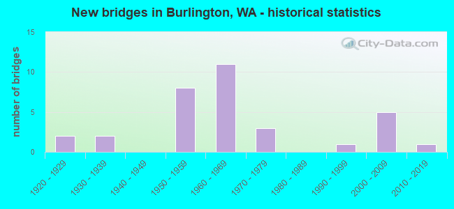
- New bridges - historical statistics
- 21920-1929
- 21930-1939
- 81950-1959
- 111960-1969
- 31970-1979
- 11990-1999
- 52000-2009
- 12010-2019


- Bridge Condition - Deck
- 3.7%Very good
- 37.0%Good
- 48.1%Satisfactory
- 3.7%Fair
- 7.4%Poor

- Bridge Condition - Superstructure
- 3.6%Very good
- 60.7%Good
- 25.0%Satisfactory
- 10.7%Fair

- Bridge Condition - Substructure
- 7.1%Very good
- 71.4%Good
- 17.9%Satisfactory
- 3.6%Poor

- Bridge Condition - Channel
- 71.4%Very good
- 14.3%Good
- 14.3%Satisfactory
Find on map >> Show street view
Structure Number: 397A, Location: 2.9 N JCT I-5 (Lat: 48.516917, Lng: -122.378750), Route carried "on" structure: State highway 11, Year Built: 1920, Status: Open, Structure Length: 2.29m (7.51ft), Average Daily Traffic: 4,096 (year 2019), Truck Traffic: 7%, Average Future Daily Traffic: 6,029 (year 2039), Features Intersected: SAMISH RIVER
Minimum Vertical Clearance: 30+ m (98+ ft), Kilometerpoint: 4.715, Lanes on structure: 2, Owner: State Highway Agency, Approaching Roadway Width: 8.5m (27.9ft), Skew: 3 degrees, Material/Design: Concrete, Design/Construction: Arch - Deck, Number Of Spans In Main Unit: 1, Length of Maximum Span: 22.9m (75.1ft), Curb or Sidewalk Widths: Left: 0.0m, Right: 1.4m (4.6ft), Curb-To-Curb Width: 6.7m (22.0ft), Out-to-Out Width: 7.9m (25.9ft)
Condition: Superstructure: Satisfactory, Substructure: Good, Channel: Very good, Operating Rating: 46.7 metric tons, Method Used To Determine Operating Rating: Load and Resistance Factor Rating (LRFR) rating reported by rating factor(RF) method using HL-93 loadings, Inventory Rating: 36.0 metric tons, Method Used To Determine Inventory Rating: Load and Resistance Factor Rating (LRFR) rating reported by rating factor(RF) method using HL-93 loadings, Structural Evaluation: Equal to present minimum criteria, Deck Geometry: High priority of replacement, Waterway Adequacy: Equal to present desirable criteria, Approach Roadway Alignment: Equal to present desirable criteria, Length Of Structure Improvement: 2.29m (7.51ft), Designated Inspection Frequency: Every 48 months, Inspection Date: September 2018, Bridge Improvement Cost: $450,000, Roadway Improvement Cost: $90,000, Total Project Cost: $900,000 ( Estimate for 2014), Wearing Surface/Protective System: Wearing Surface: Bituminous
Find on map >> Show street view
Structure Number: 584A, Location: 0.7 N JCT I-5 (Lat: 48.493278, Lng: -122.346944), Route carried "on" structure: State highway 11, Year Built: 1922, Status: Open, Structure Length: 0.98m (3.22ft), Average Daily Traffic: 4,909 (year 2019), Truck Traffic: 6%, Average Future Daily Traffic: 7,226 (year 2039), Design Load: H 20, Features Intersected: JOE LEARY SLOUGH
Minimum Vertical Clearance: 30+ m (98+ ft), Kilometerpoint: 1.223, Lanes on structure: 2, Owner: State Highway Agency, Approaching Roadway Width: 9.8m (32.2ft), Skew: 4 degrees, Material/Design: Concrete, Design/Construction: Slab, Number Of Spans In Main Unit: 1, Length of Maximum Span: 9.1m (29.9ft), Curb or Sidewalk Widths: Left: 0.2m (0.7ft), Right: 0.2m (0.7ft), Curb-To-Curb Width: 7.3m (24.0ft), Out-to-Out Width: 8.2m (26.9ft)
Condition: Deck: Satisfactory, Superstructure: Fair, Substructure: Good, Channel: Very good, Operating Rating: 32.7 metric tons, Method Used To Determine Operating Rating: Load and Resistance Factor Rating (LRFR) rating reported by rating factor(RF) method using HL-93 loadings, Inventory Rating: 25.3 metric tons, Method Used To Determine Inventory Rating: Load and Resistance Factor Rating (LRFR) rating reported by rating factor(RF) method using HL-93 loadings, Structural Evaluation: Somewhat better than minimum adequacy, Deck Geometry: High priority of replacement, Waterway Adequacy: Equal to present desirable criteria, Approach Roadway Alignment: Equal to present desirable criteria, Length Of Structure Improvement: 0.98m (3.22ft), Designated Inspection Frequency: Every 24 months, Inspection Date: March 2020, Bridge Improvement Cost: $218,000, Roadway Improvement Cost: $44,000, Total Project Cost: $435,000 ( Estimate for 2014), Deck Structure Type: Concrete Cast-file-Place, Wearing Surface/Protective System: Wearing Surface: Bituminous
Find on map >> Show street view
Structure Number: 4795B, Location: 1.7 N JCT SR 538 (Lat: 48.458806, Lng: -122.341389), Route carried "on" structure: Interstate 5, Year Built: 1954, Year Reconstructed: 1973, Status: Open, Structure Length: 3.17m (10.40ft), Average Daily Traffic: 33,164 (year 2019), Truck Traffic: 9%, Average Future Daily Traffic: 48,817 (year 2039), Design Load: HS 20+Mod, Features Intersected: GAGES SLOUGH
Minimum Vertical Clearance: 30+ m (98+ ft), Kilometerpoint: 369.071, Lanes on structure: 2, Base Highway Network: Yes, Owner: State Highway Agency, Approaching Roadway Width: 11.6m (38.1ft), Material/Design: Concrete continuous, Design/Construction: Slab, Number Of Spans In Main Unit: 5, Length of Maximum Span: 6.7m (22.0ft), Curb-To-Curb Width: 11.6m (38.1ft), Out-to-Out Width: 12.5m (41.0ft)
Condition: Deck: Good, Superstructure: Good, Substructure: Good, Channel: Very good, Operating Rating: 38.2 metric tons, Method Used To Determine Operating Rating: Load and Resistance Factor Rating (LRFR) rating reported by rating factor(RF) method using HL-93 loadings, Inventory Rating: 29.5 metric tons, Method Used To Determine Inventory Rating: Load and Resistance Factor Rating (LRFR) rating reported by rating factor(RF) method using HL-93 loadings, Structural Evaluation: Better than present minimum criteria, Deck Geometry: Equal to present minimum criteria, Waterway Adequacy: Equal to present desirable criteria, Approach Roadway Alignment: Equal to present desirable criteria, Length Of Structure Improvement: 3.17m (10.40ft), Designated Inspection Frequency: Every 24 months, Inspection Date: March 2021, Bridge Improvement Cost: $832,000, Roadway Improvement Cost: $166,000, Total Project Cost: $1,664,000 ( Estimate for 2014), Deck Structure Type: Concrete Cast-file-Place, Wearing Surface/Protective System: Wearing Surface: Bituminous
Find on map >> Show street view
Structure Number: 4795C, Location: 1.7 N JCT SR 538 (Lat: 48.458806, Lng: -122.341611), Route carried "on" structure: Interstate 5, Year Built: 1954, Year Reconstructed: 1973, Status: Open, Structure Length: 3.17m (10.40ft), Average Daily Traffic: 33,164 (year 2019), Truck Traffic: 9%, Average Future Daily Traffic: 48,817 (year 2039), Design Load: HS 20+Mod, Features Intersected: GAGES SLOUGH
Minimum Vertical Clearance: 30+ m (98+ ft), Kilometerpoint: 369.071, Lanes on structure: 2, Base Highway Network: Yes, Owner: State Highway Agency, Approaching Roadway Width: 11.6m (38.1ft), Material/Design: Concrete continuous, Design/Construction: Slab, Number Of Spans In Main Unit: 5, Length of Maximum Span: 6.7m (22.0ft), Curb-To-Curb Width: 11.6m (38.1ft), Out-to-Out Width: 12.5m (41.0ft)
Condition: Deck: Good, Superstructure: Good, Substructure: Good, Channel: Very good, Operating Rating: 38.2 metric tons, Method Used To Determine Operating Rating: Load and Resistance Factor Rating (LRFR) rating reported by rating factor(RF) method using HL-93 loadings, Inventory Rating: 29.5 metric tons, Method Used To Determine Inventory Rating: Load and Resistance Factor Rating (LRFR) rating reported by rating factor(RF) method using HL-93 loadings, Structural Evaluation: Better than present minimum criteria, Deck Geometry: Equal to present minimum criteria, Waterway Adequacy: Equal to present desirable criteria, Approach Roadway Alignment: Equal to present desirable criteria, Length Of Structure Improvement: 3.17m (10.40ft), Designated Inspection Frequency: Every 24 months, Inspection Date: March 2021, Bridge Improvement Cost: $832,000, Roadway Improvement Cost: $166,000, Total Project Cost: $1,664,000 ( Estimate for 2014), Deck Structure Type: Concrete Cast-file-Place, Wearing Surface/Protective System: Wearing Surface: Bituminous
Find on map >> Show street view
Structure Number: 4833A, Location: 2.4 N JCT SR 538 (Lat: 48.470472, Lng: -122.342044), Route carried "on" structure: Interstate 5, Year Built: 1955, Year Reconstructed: 1972, Status: Open, Structure Length: 7.44m (24.41ft), Average Daily Traffic: 76,510 (year 2019), Truck Traffic: 9%, Average Future Daily Traffic: 112,622 (year 2039), Design Load: HS 20+Mod, Features Intersected: SR 20, BNSF RR & CITY ST
Minimum Vertical Clearance: 30+ m (98+ ft), Kilometerpoint: 370.374, Lanes on structure: 6, Lanes under structure: 6, Base Highway Network: Yes, Owner: State Highway Agency, Approaching Roadway Width: 35.1m (115.2ft), Skew: 32 degrees, Material/Design: Concrete continuous, Design/Construction: Tee Beam, Number Of Spans In Main Unit: 4, Length of Maximum Span: 21.3m (69.9ft), Curb-To-Curb Width: 35.4m (116.1ft), Out-to-Out Width: 36.1m (118.4ft)
Condition: Deck: Good, Superstructure: Good, Substructure: Good, Operating Rating: 20.7 metric tons, Method Used To Determine Operating Rating: Load and Resistance Factor Rating (LRFR) rating reported by rating factor(RF) method using HL-93 loadings, Inventory Rating: 15.9 metric tons, Method Used To Determine Inventory Rating: Load and Resistance Factor Rating (LRFR) rating reported by rating factor(RF) method using HL-93 loadings, Structural Evaluation: High priority of corrective action, Deck Geometry: Superior to present desirable criteria, Underclear: High priority of corrective action, Approach Roadway Alignment: Equal to present desirable criteria, Length Of Structure Improvement: 7.44m (24.41ft), Designated Inspection Frequency: Every 24 months, Inspection Date: March 2021, Bridge Improvement Cost: $5,710,000, Roadway Improvement Cost: $1,142,000, Total Project Cost: $11,419,000 ( Estimate for 2014), Deck Structure Type: Concrete Cast-file-Place, Wearing Surface/Protective System: Wearing Surface: Bituminous
Find on map >> Show street view
Structure Number: 6011A, Location: JCT I-5 (Lat: 48.485222, Lng: -122.337583), Route carried "on" structure: State highway 11, Year Built: 1959, Status: Open, Structure Length: 8.78m (28.81ft), Average Daily Traffic: 10,391 (year 2019), Truck Traffic: 9%, Average Future Daily Traffic: 15,295 (year 2039), Design Load: HS 20, Features Intersected: I-5
Minimum Vertical Clearance: 30+ m (98+ ft), Kilometerpoint: 0.001, Lanes on structure: 2, Lanes under structure: 6, Owner: State Highway Agency, Approaching Roadway Width: 12.2m (40.0ft), Skew: 1 degrees, Material/Design: Prestressed concrete, Design/Construction: Stringer/Multi-beam, Number Of Spans In Main Unit: 4, Length of Maximum Span: 24.1m (79.1ft), Curb-To-Curb Width: 9.6m (31.5ft), Out-to-Out Width: 10.5m (34.4ft)
Condition: Deck: Satisfactory, Superstructure: Satisfactory, Substructure: Satisfactory, Operating Rating: 64.4 metric tons, Method Used To Determine Operating Rating: Load Factor (LF), Inventory Rating: 38.1 metric tons, Method Used To Determine Inventory Rating: Load Factor (LF), Structural Evaluation: Equal to present minimum criteria, Deck Geometry: Meets minimum limits, Underclear: High priority of corrective action, Approach Roadway Alignment: Equal to present desirable criteria, Length Of Structure Improvement: 8.78m (28.81ft), Designated Inspection Frequency: Every 24 months, Inspection Date: May 2021, Bridge Improvement Cost: $2,419,000, Roadway Improvement Cost: $484,000, Total Project Cost: $4,838,000 ( Estimate for 2014), Deck Structure Type: Concrete Cast-file-Place, Wearing Surface/Protective System: Wearing Surface: Latex Concrete
Find on map >> Show street view
Structure Number: 7124A, Location: 2.1 N JCT SR 11 (Lat: 48.514444, Lng: -122.343056), Route carried "on" structure: Interstate 5, Year Built: 1963, Status: Open, Structure Length: 8.23m (27.00ft), Average Daily Traffic: 26,796 (year 2019), Truck Traffic: 7%, Average Future Daily Traffic: 39,443 (year 2039), Design Load: HS 20, Features Intersected: GN RY
Minimum Vertical Clearance: 30+ m (98+ ft), Kilometerpoint: 375.508, Lanes on structure: 2, Base Highway Network: Yes, Owner: State Highway Agency, Approaching Roadway Width: 11.6m (38.1ft), Material/Design: Concrete continuous, Design/Construction: Box Beam or Girders - Multiple, Number Of Spans In Main Unit: 5, Length of Maximum Span: 24.4m (80.1ft), Curb-To-Curb Width: 10.1m (33.1ft), Out-to-Out Width: 11.0m (36.1ft)
Condition: Deck: Satisfactory, Superstructure: Good, Substructure: Good, Operating Rating: 42.4 metric tons, Method Used To Determine Operating Rating: Load and Resistance Factor Rating (LRFR) rating reported by rating factor(RF) method using HL-93 loadings, Inventory Rating: 32.7 metric tons, Method Used To Determine Inventory Rating: Load and Resistance Factor Rating (LRFR) rating reported by rating factor(RF) method using HL-93 loadings, Structural Evaluation: Better than present minimum criteria, Deck Geometry: Meets minimum limits, Underclear: Equal to present minimum criteria, Approach Roadway Alignment: Equal to present desirable criteria, Length Of Structure Improvement: 8.23m (27.00ft), Designated Inspection Frequency: Every 24 months, Inspection Date: July 2020, Bridge Improvement Cost: $2,160,000, Roadway Improvement Cost: $432,000, Total Project Cost: $4,320,000 ( Estimate for 2014), Deck Structure Type: Concrete Cast-file-Place, Wearing Surface/Protective System: Wearing Surface: Latex Concrete
Find on map >> Show street view
Structure Number: 7124B, Location: 2.1 N JCT SR 11 (Lat: 48.514667, Lng: -122.343500), Route carried "on" structure: Interstate 5, Year Built: 1963, Status: Open, Structure Length: 8.23m (27.00ft), Average Daily Traffic: 26,796 (year 2019), Truck Traffic: 7%, Average Future Daily Traffic: 39,443 (year 2039), Design Load: HS 20, Features Intersected: GN RY
Minimum Vertical Clearance: 30+ m (98+ ft), Kilometerpoint: 375.540, Lanes on structure: 2, Base Highway Network: Yes, Owner: State Highway Agency, Approaching Roadway Width: 11.6m (38.1ft), Material/Design: Concrete continuous, Design/Construction: Box Beam or Girders - Multiple, Number Of Spans In Main Unit: 5, Length of Maximum Span: 24.4m (80.1ft), Curb-To-Curb Width: 10.0m (32.8ft), Out-to-Out Width: 10.9m (35.8ft)
Condition: Deck: Satisfactory, Superstructure: Good, Substructure: Good, Operating Rating: 42.4 metric tons, Method Used To Determine Operating Rating: Load and Resistance Factor Rating (LRFR) rating reported by rating factor(RF) method using HL-93 loadings, Inventory Rating: 32.7 metric tons, Method Used To Determine Inventory Rating: Load and Resistance Factor Rating (LRFR) rating reported by rating factor(RF) method using HL-93 loadings, Structural Evaluation: Better than present minimum criteria, Deck Geometry: Meets minimum limits, Underclear: Somewhat better than minimum adequacy, Approach Roadway Alignment: Equal to present desirable criteria, Length Of Structure Improvement: 8.23m (27.00ft), Designated Inspection Frequency: Every 48 months, Inspection Date: May 2018, Bridge Improvement Cost: $2,160,000, Roadway Improvement Cost: $432,000, Total Project Cost: $4,320,000 ( Estimate for 2014), Deck Structure Type: Concrete Cast-file-Place, Wearing Surface/Protective System: Wearing Surface: Latex Concrete
Find on map >> Show street view
Structure Number: 7127A, Location: 1.6 N JCT SR 11 (Lat: 48.507750, Lng: -122.339611), Route carried "on" structure: County highway , Year Built: 1963, Status: Open, Structure Length: 3.87m (12.70ft), Average Daily Traffic: 10,683 (year 2012), Truck Traffic: 1%, Average Future Daily Traffic: 17,093 (year 2036), Design Load: HS 20, Features Intersected: I-5, Facility Carried by Structure: COOK RD
Minimum Vertical Clearance: 30+ m (98+ ft), Kilometerpoint: 0.080, Lanes on structure: 2, Lanes under structure: 4, Owner: State Highway Agency, Approaching Roadway Width: 12.2m (40.0ft), Skew: 2 degrees, Material/Design: Concrete continuous, Design/Construction: Slab, Number Of Spans In Main Unit: 2, Length of Maximum Span: 18.6m (61.0ft), Curb or Sidewalk Widths: Left: 0.6m (2.0ft), Right: 0.6m (2.0ft), Curb-To-Curb Width: 8.5m (27.9ft), Out-to-Out Width: 10.9m (35.8ft)
Condition: Deck: Good, Superstructure: Satisfactory, Substructure: Good, Operating Rating: 49.9 metric tons, Method Used To Determine Operating Rating: Load and Resistance Factor Rating (LRFR) rating reported by rating factor(RF) method using HL-93 loadings, Inventory Rating: 38.2 metric tons, Method Used To Determine Inventory Rating: Load and Resistance Factor Rating (LRFR) rating reported by rating factor(RF) method using HL-93 loadings, Structural Evaluation: Equal to present minimum criteria, Deck Geometry: High priority of replacement, Underclear: Somewhat better than minimum adequacy, Approach Roadway Alignment: Equal to present desirable criteria, Length Of Structure Improvement: 3.87m (12.70ft), Designated Inspection Frequency: Every 24 months, Inspection Date: March 2020, Bridge Improvement Cost: $1,067,000, Roadway Improvement Cost: $213,000, Total Project Cost: $2,134,000 ( Estimate for 2014), Deck Structure Type: Concrete Cast-file-Place, Wearing Surface/Protective System: Wearing Surface: Bituminous, Membrane: Preformed Fabric
Find on map >> Show street view
Structure Number: 7141A, Location: 2.9 N JCT SR 11 (Lat: 48.524083, Lng: -122.348806), Route carried "on" structure: Interstate 5, Year Built: 1963, Status: Open, Structure Length: 5.70m (18.70ft), Average Daily Traffic: 26,796 (year 2019), Truck Traffic: 7%, Average Future Daily Traffic: 39,443 (year 2039), Design Load: HS 20, Features Intersected: SAMISH RIVER, PVT RD
Minimum Vertical Clearance: 30+ m (98+ ft), Kilometerpoint: 376.651, Lanes on structure: 2, Base Highway Network: Yes, Owner: State Highway Agency, Approaching Roadway Width: 11.6m (38.1ft), Material/Design: Concrete continuous, Design/Construction: Slab, Number Of Spans In Main Unit: 5, Length of Maximum Span: 14.6m (47.9ft), Curb-To-Curb Width: 10.1m (33.1ft), Out-to-Out Width: 11.0m (36.1ft)
Condition: Deck: Satisfactory, Superstructure: Good, Substructure: Satisfactory, Channel: Satisfactory, Operating Rating: 42.8 metric tons, Method Used To Determine Operating Rating: Load and Resistance Factor Rating (LRFR) rating reported by rating factor(RF) method using HL-93 loadings, Inventory Rating: 33.0 metric tons, Method Used To Determine Inventory Rating: Load and Resistance Factor Rating (LRFR) rating reported by rating factor(RF) method using HL-93 loadings, Structural Evaluation: Equal to present minimum criteria, Deck Geometry: High priority of corrective action, Waterway Adequacy: Equal to present desirable criteria, Approach Roadway Alignment: Equal to present desirable criteria, Length Of Structure Improvement: 5.70m (18.70ft), Designated Inspection Frequency: Every 48 months, Inspection Date: May 2018, Bridge Improvement Cost: $1,496,000, Roadway Improvement Cost: $299,000, Total Project Cost: $2,992,000 ( Estimate for 2014), Deck Structure Type: Concrete Precast Panels, Wearing Surface/Protective System: Wearing Surface: Latex Concrete
Find on map >> Show street view
Structure Number: 7141B, Location: 2.9 N JCT SR 11 (Lat: 48.524000, Lng: -122.349028), Route carried "on" structure: Interstate 5, Year Built: 1963, Status: Open, Structure Length: 5.70m (18.70ft), Average Daily Traffic: 26,796 (year 2019), Truck Traffic: 7%, Average Future Daily Traffic: 39,443 (year 2039), Design Load: HS 20, Features Intersected: SAMISH RIVER, PVT RD
Minimum Vertical Clearance: 30+ m (98+ ft), Kilometerpoint: 376.651, Lanes on structure: 2, Base Highway Network: Yes, Owner: State Highway Agency, Approaching Roadway Width: 11.9m (39.0ft), Material/Design: Concrete continuous, Design/Construction: Slab, Number Of Spans In Main Unit: 5, Length of Maximum Span: 14.6m (47.9ft), Curb-To-Curb Width: 10.2m (33.5ft), Out-to-Out Width: 10.9m (35.8ft)
Condition: Deck: Poor, Superstructure: Satisfactory, Substructure: Good, Channel: Satisfactory, Operating Rating: 40.5 metric tons, Method Used To Determine Operating Rating: Load and Resistance Factor Rating (LRFR) rating reported by rating factor(RF) method using HL-93 loadings, Inventory Rating: 31.1 metric tons, Method Used To Determine Inventory Rating: Load and Resistance Factor Rating (LRFR) rating reported by rating factor(RF) method using HL-93 loadings, Structural Evaluation: Equal to present minimum criteria, Deck Geometry: High priority of corrective action, Waterway Adequacy: Equal to present desirable criteria, Approach Roadway Alignment: Equal to present desirable criteria, Length Of Structure Improvement: 5.70m (18.70ft), Designated Inspection Frequency: Every 24 months, Inspection Date: May 2020, Bridge Improvement Cost: $1,821,000, Roadway Improvement Cost: $364,000, Total Project Cost: $3,642,000 ( Estimate for 2022), Deck Structure Type: Concrete Cast-file-Place, Wearing Surface/Protective System: Wearing Surface: Monolithic Concrete
Find on map >> Show street view
Structure Number: 7216A, Location: 0.6 N JCT SR 11 (Lat: 48.493083, Lng: -122.335361), Route carried "on" structure: Interstate 5, Year Built: 1963, Status: Open, Structure Length: 2.07m (6.79ft), Average Daily Traffic: 27,582 (year 2019), Truck Traffic: 7%, Average Future Daily Traffic: 40,600 (year 2039), Design Load: HS 20, Features Intersected: DRAINAGE DITCH
Minimum Vertical Clearance: 30+ m (98+ ft), Kilometerpoint: 373.030, Lanes on structure: 2, Base Highway Network: Yes, Owner: State Highway Agency, Approaching Roadway Width: 11.6m (38.1ft), Material/Design: Concrete continuous, Design/Construction: Slab, Number Of Spans In Main Unit: 3, Length of Maximum Span: 13.7m (44.9ft), Curb-To-Curb Width: 11.6m (38.1ft), Out-to-Out Width: 12.6m (41.3ft)
Condition: Deck: Satisfactory, Superstructure: Good, Substructure: Good, Channel: Very good, Operating Rating: 73.5 metric tons, Method Used To Determine Operating Rating: Load Factor (LF), Inventory Rating: 43.5 metric tons, Method Used To Determine Inventory Rating: Load Factor (LF), Structural Evaluation: Better than present minimum criteria, Deck Geometry: Equal to present minimum criteria, Waterway Adequacy: Equal to present desirable criteria, Approach Roadway Alignment: Equal to present desirable criteria, Length Of Structure Improvement: 2.07m (6.79ft), Designated Inspection Frequency: Every 24 months, Inspection Date: March 2020, Bridge Improvement Cost: $544,000, Roadway Improvement Cost: $109,000, Total Project Cost: $1,088,000 ( Estimate for 2014), Deck Structure Type: Concrete Cast-file-Place, Wearing Surface/Protective System: Wearing Surface: Monolithic Concrete
Find on map >> Show street view
Structure Number: 7216B, Location: 0.6 N JCT SR 11 (Lat: 48.493083, Lng: -122.335639), Route carried "on" structure: Interstate 5, Year Built: 1964, Status: Open, Structure Length: 2.07m (6.79ft), Average Daily Traffic: 27,582 (year 2019), Truck Traffic: 7%, Average Future Daily Traffic: 40,600 (year 2039), Design Load: HS 20, Features Intersected: JOE LEARY SLOUGH
Minimum Vertical Clearance: 30+ m (98+ ft), Kilometerpoint: 373.030, Lanes on structure: 2, Base Highway Network: Yes, Owner: State Highway Agency, Approaching Roadway Width: 11.6m (38.1ft), Material/Design: Concrete continuous, Design/Construction: Slab, Number Of Spans In Main Unit: 3, Length of Maximum Span: 13.7m (44.9ft), Curb-To-Curb Width: 11.6m (38.1ft), Out-to-Out Width: 12.6m (41.3ft)
Condition: Deck: Satisfactory, Superstructure: Good, Substructure: Good, Channel: Very good, Operating Rating: 73.5 metric tons, Method Used To Determine Operating Rating: Load Factor (LF), Inventory Rating: 43.5 metric tons, Method Used To Determine Inventory Rating: Load Factor (LF), Structural Evaluation: Better than present minimum criteria, Deck Geometry: Equal to present minimum criteria, Waterway Adequacy: Equal to present desirable criteria, Approach Roadway Alignment: Equal to present desirable criteria, Length Of Structure Improvement: 2.07m (6.79ft), Designated Inspection Frequency: Every 24 months, Inspection Date: March 2020, Bridge Improvement Cost: $544,000, Roadway Improvement Cost: $109,000, Total Project Cost: $1,088,000 ( Estimate for 2014), Deck Structure Type: Concrete Cast-file-Place, Wearing Surface/Protective System: Wearing Surface: Monolithic Concrete
Find on map >> Show street view
Structure Number: 7216C, Location: 2.4 N JCT SR 11 (Lat: 48.518833, Lng: -122.345694), Route carried "on" structure: Interstate 5, Year Built: 1964, Status: Open, Structure Length: 4.63m (15.19ft), Average Daily Traffic: 26,796 (year 2019), Truck Traffic: 7%, Average Future Daily Traffic: 39,443 (year 2039), Design Load: HS 20, Features Intersected: DRAINAGE DITCH
Minimum Vertical Clearance: 30+ m (98+ ft), Kilometerpoint: 376.023, Lanes on structure: 2, Base Highway Network: Yes, Owner: State Highway Agency, Approaching Roadway Width: 11.6m (38.1ft), Material/Design: Concrete continuous, Design/Construction: Slab, Number Of Spans In Main Unit: 5, Length of Maximum Span: 10.4m (34.1ft), Curb-To-Curb Width: 11.9m (39.0ft), Out-to-Out Width: 12.8m (42.0ft)
Condition: Deck: Satisfactory, Superstructure: Good, Substructure: Good, Channel: Very good, Operating Rating: 37.9 metric tons, Method Used To Determine Operating Rating: Load and Resistance Factor Rating (LRFR) rating reported by rating factor(RF) method using HL-93 loadings, Inventory Rating: 29.2 metric tons, Method Used To Determine Inventory Rating: Load and Resistance Factor Rating (LRFR) rating reported by rating factor(RF) method using HL-93 loadings, Structural Evaluation: Better than present minimum criteria, Deck Geometry: Equal to present minimum criteria, Waterway Adequacy: Equal to present desirable criteria, Approach Roadway Alignment: Equal to present desirable criteria, Length Of Structure Improvement: 4.63m (15.19ft), Designated Inspection Frequency: Every 24 months, Inspection Date: March 2021, Bridge Improvement Cost: $1,216,000, Roadway Improvement Cost: $243,000, Total Project Cost: $2,432,000 ( Estimate for 2014), Deck Structure Type: Concrete Cast-file-Place, Wearing Surface/Protective System: Wearing Surface: Monolithic Concrete
Find on map >> Show street view
Structure Number: 7216D, Location: 2.4 N JCT SR 11 (Lat: 48.518964, Lng: -122.346078), Route carried "on" structure: Interstate 5, Year Built: 1964, Status: Open, Structure Length: 4.63m (15.19ft), Average Daily Traffic: 26,796 (year 2019), Truck Traffic: 7%, Average Future Daily Traffic: 39,443 (year 2039), Design Load: HS 20, Features Intersected: DRAINAGE DITCH
Minimum Vertical Clearance: 30+ m (98+ ft), Kilometerpoint: 376.023, Lanes on structure: 2, Base Highway Network: Yes, Owner: State Highway Agency, Approaching Roadway Width: 11.9m (39.0ft), Material/Design: Concrete continuous, Design/Construction: Slab, Number Of Spans In Main Unit: 5, Length of Maximum Span: 10.4m (34.1ft), Curb-To-Curb Width: 11.6m (38.1ft), Out-to-Out Width: 12.5m (41.0ft)
Condition: Deck: Satisfactory, Superstructure: Good, Substructure: Good, Channel: Very good, Operating Rating: 37.9 metric tons, Method Used To Determine Operating Rating: Load and Resistance Factor Rating (LRFR) rating reported by rating factor(RF) method using HL-93 loadings, Inventory Rating: 29.2 metric tons, Method Used To Determine Inventory Rating: Load and Resistance Factor Rating (LRFR) rating reported by rating factor(RF) method using HL-93 loadings, Structural Evaluation: Better than present minimum criteria, Deck Geometry: Equal to present minimum criteria, Waterway Adequacy: Equal to present desirable criteria, Approach Roadway Alignment: Equal to present desirable criteria, Length Of Structure Improvement: 4.63m (15.19ft), Designated Inspection Frequency: Every 24 months, Inspection Date: March 2021, Bridge Improvement Cost: $1,246,000, Roadway Improvement Cost: $249,000, Total Project Cost: $2,493,000 ( Estimate for 2014), Deck Structure Type: Concrete Cast-file-Place, Wearing Surface/Protective System: Wearing Surface: Monolithic Concrete
Find on map >> Show street view
Structure Number: 8453B, Location: 2.2 E JCT SR 536 (Lat: 48.455250, Lng: -122.388833), Route carried "on" structure: State highway 20, Year Built: 1968, Status: Open, Structure Length: 2.19m (7.19ft), Average Daily Traffic: 13,918 (year 2019), Truck Traffic: 8%, Average Future Daily Traffic: 20,487 (year 2039), Design Load: HS 20+Mod, Features Intersected: HIGGINS SLOUGH
Minimum Vertical Clearance: 30+ m (98+ ft), Kilometerpoint: 91.958, Lanes on structure: 2, Base Highway Network: Yes, Owner: State Highway Agency, Approaching Roadway Width: 11.6m (38.1ft), Skew: 1 degrees, Material/Design: Concrete continuous, Design/Construction: Slab, Number Of Spans In Main Unit: 3, Length of Maximum Span: 8.5m (27.9ft), Curb or Sidewalk Widths: Left: 0.2m (0.7ft), Right: 0.2m (0.7ft), Curb-To-Curb Width: 12.2m (40.0ft), Out-to-Out Width: 13.3m (43.6ft)
Condition: Deck: Good, Superstructure: Good, Substructure: Good, Channel: Very good, Operating Rating: 41.1 metric tons, Method Used To Determine Operating Rating: Load and Resistance Factor Rating (LRFR) rating reported by rating factor(RF) method using HL-93 loadings, Inventory Rating: 31.8 metric tons, Method Used To Determine Inventory Rating: Load and Resistance Factor Rating (LRFR) rating reported by rating factor(RF) method using HL-93 loadings, Structural Evaluation: Better than present minimum criteria, Deck Geometry: Better than present minimum criteria, Waterway Adequacy: Equal to present desirable criteria, Approach Roadway Alignment: Equal to present desirable criteria, Length Of Structure Improvement: 2.19m (7.19ft), Designated Inspection Frequency: Every 24 months, Inspection Date: March 2021, Bridge Improvement Cost: $576,000, Roadway Improvement Cost: $115,000, Total Project Cost: $1,152,000 ( Estimate for 2014), Deck Structure Type: Concrete Cast-file-Place, Wearing Surface/Protective System: Wearing Surface: Bituminous, Membrane: Preformed Fabric
Find on map >> Show street view
Structure Number: 9547A, Location: 1.1 N JCT SR 538 (Lat: 48.452169, Lng: -122.341692), Route carried "on" structure: County highway , Year Built: 1974, Status: Open, Structure Length: 6.37m (20.90ft), Average Daily Traffic: 11,673 (year 2007), Truck Traffic: 1%, Average Future Daily Traffic: 20,136 (year 2036), Design Load: HS 20+Mod, Features Intersected: I-5, Facility Carried by Structure: GEORGE HOPPER RD
Minimum Vertical Clearance: 30+ m (98+ ft), Kilometerpoint: 0.257, Lanes on structure: 3, Lanes under structure: 4, Owner: State Highway Agency, Approaching Roadway Width: 11.6m (38.1ft), Material/Design: Prestressed concrete continuous, Design/Construction: Stringer/Multi-beam, Number Of Spans In Main Unit: 2, Length of Maximum Span: 37.2m (122.0ft), Curb-To-Curb Width: 11.6m (38.1ft), Out-to-Out Width: 12.6m (41.3ft)
Condition: Deck: Satisfactory, Superstructure: Good, Substructure: Good, Operating Rating: 63.5 metric tons, Method Used To Determine Operating Rating: Load Factor (LF), Inventory Rating: 37.2 metric tons, Method Used To Determine Inventory Rating: Load Factor (LF), Structural Evaluation: Better than present minimum criteria, Deck Geometry: High priority of replacement, Underclear: Equal to present minimum criteria, Approach Roadway Alignment: Equal to present desirable criteria, Length Of Structure Improvement: 6.37m (20.90ft), Designated Inspection Frequency: Every 48 months, Inspection Date: May 2018, Bridge Improvement Cost: $1,672,000, Roadway Improvement Cost: $334,000, Total Project Cost: $3,344,000 ( Estimate for 2014), Deck Structure Type: Concrete Cast-file-Place, Wearing Surface/Protective System: Wearing Surface: Monolithic Concrete
Find on map >> Show street view
Structure Number: 17484A, Location: 2.2 E JCT SR 536 (Lat: 48.455056, Lng: -122.388639), Route carried "on" structure: State highway 20, Year Built: 2008, Status: Open, Structure Length: 2.26m (7.41ft), Average Daily Traffic: 13,918 (year 2019), Truck Traffic: 8%, Average Future Daily Traffic: 20,487 (year 2039), Design Load: HL 93, Features Intersected: HIGGINS SLOUGH
Minimum Vertical Clearance: 30+ m (98+ ft), Kilometerpoint: 91.958, Lanes on structure: 2, Base Highway Network: Yes, Owner: State Highway Agency, Approaching Roadway Width: 11.6m (38.1ft), Skew: 1 degrees, Material/Design: Prestressed concrete, Design/Construction: Slab, Number Of Spans In Main Unit: 1, Length of Maximum Span: 20.4m (66.9ft), Curb-To-Curb Width: 11.6m (38.1ft), Out-to-Out Width: 12.2m (40.0ft)
Condition: Deck: Good, Superstructure: Good, Substructure: Good, Channel: Very good, Operating Rating: 89.8 metric tons, Method Used To Determine Operating Rating: Load Factor (LF), Inventory Rating: 54.4 metric tons, Method Used To Determine Inventory Rating: Load Factor (LF), Structural Evaluation: Better than present minimum criteria, Deck Geometry: Better than present minimum criteria, Waterway Adequacy: Equal to present desirable criteria, Approach Roadway Alignment: Equal to present desirable criteria, Length Of Structure Improvement: 2.26m (7.41ft), Designated Inspection Frequency: Every 48 months, Inspection Date: March 2019, Bridge Improvement Cost: $592,000, Roadway Improvement Cost: $118,000, Total Project Cost: $1,184,000 ( Estimate for 2014), Deck Structure Type: Concrete Cast-file-Place, Wearing Surface/Protective System: Wearing Surface: Monolithic Concrete, Deck Protection: Epoxy Coated Reinforcing
Find on map >> Show street view
Structure Number: 17484B, Location: 2.4 N JCT SR 538 (Lat: 48.467778, Lng: -122.344167), Route carried "on" structure: Ramp Interstate 5, Year Built: 2009, Status: Open, Structure Length: 3.51m (11.52ft), Average Daily Traffic: 5,543 (year 2019), Truck Traffic: 14%, Average Future Daily Traffic: 8,159 (year 2039), Design Load: HL 93, Features Intersected: NEVITT ROAD
Minimum Vertical Clearance: 30+ m (98+ ft), Kilometerpoint: 0.644, Lanes on structure: 3, Lanes under structure: 3, Owner: State Highway Agency, Approaching Roadway Width: 22.6m (74.1ft), Skew: 30 degrees, Material/Design: Prestressed concrete, Design/Construction: Stringer/Multi-beam, Number Of Spans In Main Unit: 1, Length of Maximum Span: 33.5m (109.9ft), Curb-To-Curb Width: 22.6m (74.1ft), Out-to-Out Width: 24.1m (79.1ft)
Condition: Deck: Good, Superstructure: Very good, Substructure: Very good, Operating Rating: 50.2 metric tons, Method Used To Determine Operating Rating: Load and Resistance Factor Rating (LRFR) rating reported by rating factor(RF) method using HL-93 loadings, Inventory Rating: 37.6 metric tons, Method Used To Determine Inventory Rating: Load and Resistance Factor Rating (LRFR) rating reported by rating factor(RF) method using HL-93 loadings, Structural Evaluation: Equal to present desirable criteria, Deck Geometry: Superior to present desirable criteria, Underclear: Superior to present desirable criteria, Approach Roadway Alignment: Equal to present desirable criteria, Length Of Structure Improvement: 3.51m (11.52ft), Designated Inspection Frequency: Every 24 months, Inspection Date: July 2021, Bridge Improvement Cost: $1,748,000, Roadway Improvement Cost: $350,000, Total Project Cost: $3,496,000 ( Estimate for 2014), Deck Structure Type: Concrete Cast-file-Place, Wearing Surface/Protective System: Wearing Surface: Monolithic Concrete, Deck Protection: Epoxy Coated Reinforcing
Find on map >> Show street view
Structure Number: 80191, Location: 2.8 W JCT SR9 (Lat: 48.468156, Lng: -122.294019), Route carried "on" structure: County highway 79000, Year Built: 1979, Status: Open, Structure Length: 3.96m (12.99ft), Average Daily Traffic: 4,395 (year 2018), Truck Traffic: 5%, Average Future Daily Traffic: 7,938 (year 2038), Design Load: HS 20, Features Intersected: NOOKACHAMPS CREEK, Facility Carried by Structure: FRANCIS ROAD
Minimum Vertical Clearance: 30+ m (98+ ft), Kilometerpoint: 0.001, Lanes on structure: 2, Owner: County Highway Agency, Approaching Roadway Width: 8.5m (27.9ft), Material/Design: Concrete, Design/Construction: Stringer/Multi-beam, Number Of Spans In Main Unit: 3, Length of Maximum Span: 30.5m (100.1ft), Curb-To-Curb Width: 8.5m (27.9ft), Out-to-Out Width: 9.1m (29.9ft)
Condition: Deck: Satisfactory, Superstructure: Satisfactory, Substructure: Good, Channel: Satisfactory, Operating Rating: 59.0 metric tons, Method Used To Determine Operating Rating: Load and Resistance Factor (LRFR), Inventory Rating: 35.4 metric tons, Method Used To Determine Inventory Rating: Load and Resistance Factor (LRFR), Structural Evaluation: Equal to present minimum criteria, Deck Geometry: Meets minimum limits, Waterway Adequacy: Meets minimum limits, Approach Roadway Alignment: Equal to present desirable criteria, Length Of Structure Improvement: 3.96m (12.99ft), Designated Inspection Frequency: Every 24 months, Inspection Date: August 2020, Bridge Improvement Cost: $780,000, Roadway Improvement Cost: $156,000, Total Project Cost: $1,560,000 ( Estimate for 2014), Deck Structure Type: Concrete Cast-file-Place, Wearing Surface/Protective System: Wearing Surface: Monolithic Concrete
Find on map >> Show street view
Structure Number: 80501, Location: 2.6 N JCT COOK RD. (Lat: 48.545789, Lng: -122.338144), Route carried "on" structure: County highway 50510, Year Built: 1934, Status: Posted for load, Structure Length: 11.73m (38.48ft), Average Daily Traffic: 3,700 (year 2017), Truck Traffic: 13%, Average Future Daily Traffic: 6,682 (year 2037), Design Load: H 15, Features Intersected: SAMISH RIVER, Facility Carried by Structure: OLD HWY 99 NORTH
Minimum Vertical Clearance: 4.65m (15.26ft), Kilometerpoint: 0.001, Lanes on structure: 2, Owner: County Highway Agency, Approaching Roadway Width: 10.7m (35.1ft), Material/Design: Steel, Design/Construction: Truss - Thru, Number Of Spans In Main Unit: 1, Number Of Approach Spans: 8, Length of Maximum Span: 43.3m (142.1ft), Curb or Sidewalk Widths: Left: 0.2m (0.7ft), Right: 1.2m (3.9ft), Curb-To-Curb Width: 7.3m (24.0ft), Out-to-Out Width: 7.9m (25.9ft)
Condition: Deck: Very good, Superstructure: Satisfactory, Substructure: Satisfactory, Channel: Good, Operating Rating: 21.1 metric tons, Method Used To Determine Operating Rating: Load and Resistance Factor Rating (LRFR) rating reported by rating factor(RF) method using HL-93 loadings, Inventory Rating: 16.2 metric tons, Method Used To Determine Inventory Rating: Load and Resistance Factor Rating (LRFR) rating reported by rating factor(RF) method using HL-93 loadings, Structural Evaluation: Meets minimum limits, Deck Geometry: High priority of replacement, Waterway Adequacy: Equal to present desirable criteria, Approach Roadway Alignment: Equal to present desirable criteria, Bridge Posting: Required (Relationship of Operating Rating to Maximum Legal Load: 10.0 - 19.9% below), Length Of Structure Improvement: 11.73m (38.48ft), Designated Inspection Frequency: Every 24 months, Critical Feature Inspection Frequency: Every 24 months, Inspection Date: March 2020, Critical Feature Inspection Date: March 2020, Bridge Improvement Cost: $2,849,000, Roadway Improvement Cost: $570,000, Total Project Cost: $5,698,000 ( Estimate for 2014), Deck Structure Type: Concrete Cast-file-Place, Wearing Surface/Protective System: Wearing Surface: Monolithic Concrete
Find on map >> Show street view
Structure Number: 82204, Location: 0.01 S KELLEHER RD (Lat: 48.525028, Lng: -122.334794), Route carried "on" structure: County highway 61410, Year Built: 1958, Status: Open, Structure Length: 1.55m (5.09ft), Average Daily Traffic: 71 (year 2020), Truck Traffic: 8%, Average Future Daily Traffic: 105 (year 2040), Design Load: H 20, Features Intersected: THOMAS CREEK, Facility Carried by Structure: GREEN ROAD
Minimum Vertical Clearance: 30+ m (98+ ft), Kilometerpoint: 0.001, Lanes on structure: 2, Owner: County Highway Agency, Approaching Roadway Width: 6.1m (20.0ft), Material/Design: Concrete, Design/Construction: Tee Beam, Number Of Spans In Main Unit: 2, Length of Maximum Span: 7.6m (24.9ft), Curb-To-Curb Width: 7.3m (24.0ft), Out-to-Out Width: 7.9m (25.9ft)
Condition: Deck: Satisfactory, Superstructure: Satisfactory, Substructure: Satisfactory, Channel: Good, Operating Rating: 54.4 metric tons, Method Used To Determine Operating Rating: Field evaluation and documented engineering judgment, Inventory Rating: 32.7 metric tons, Method Used To Determine Inventory Rating: Field evaluation and documented engineering judgment, Structural Evaluation: Equal to present minimum criteria, Deck Geometry: Equal to present minimum criteria, Waterway Adequacy: Somewhat better than minimum adequacy, Approach Roadway Alignment: Equal to present desirable criteria, Length Of Structure Improvement: 1.86m (6.10ft), Designated Inspection Frequency: Every 24 months, Inspection Date: September 2020, Bridge Improvement Cost: $927,000, Roadway Improvement Cost: $185,000, Total Project Cost: $1,854,000 ( Estimate for 2014), Deck Structure Type: Concrete Cast-file-Place, Wearing Surface/Protective System: Wearing Surface: Monolithic Concrete
Find on map >> Show street view
Structure Number: 82392, Location: 1.4 N JCT COOK RD. (Lat: 48.525806, Lng: -122.340167), Route carried "on" structure: County highway 50510, Year Built: 1934, Status: Temporarily open, Structure Length: 1.58m (5.18ft), Average Daily Traffic: 4,372 (year 2019), Truck Traffic: 10%, Average Future Daily Traffic: 7,895 (year 2039), Design Load: HS 20, Features Intersected: THOMAS CREEK, Facility Carried by Structure: OLD HWY 99 NORTH
Minimum Vertical Clearance: 30+ m (98+ ft), Kilometerpoint: 0.001, Lanes on structure: 2, Owner: County Highway Agency, Approaching Roadway Width: 10.4m (34.1ft), Material/Design: Wood or Timber, Design/Construction: Stringer/Multi-beam, Number Of Spans In Main Unit: 3, Length of Maximum Span: 5.5m (18.0ft), Curb-To-Curb Width: 9.1m (29.9ft), Out-to-Out Width: 9.8m (32.2ft)
Condition: Deck: Poor, Superstructure: Fair, Substructure: Poor, Channel: Very good, Operating Rating: 15.2 metric tons, Method Used To Determine Operating Rating: Allowable Stress (AS) rating reported by rating factor (RF) method using MS18 loading, Inventory Rating: 6.2 metric tons, Method Used To Determine Inventory Rating: Allowable Stress (AS) rating reported by rating factor (RF) method using MS18 loading, Structural Evaluation: High priority of replacement, Deck Geometry: Meets minimum limits, Waterway Adequacy: Somewhat better than minimum adequacy, Approach Roadway Alignment: Equal to present desirable criteria, Bridge Posting: Required (Relationship of Operating Rating to Maximum Legal Load: > 39.9% below), Length Of Structure Improvement: 1.89m (6.20ft), Designated Inspection Frequency: Every 24 months, Inspection Date: August 2020, Bridge Improvement Cost: $942,000, Roadway Improvement Cost: $188,000, Total Project Cost: $1,885,000 ( Estimate for 2014), Deck Structure Type: Concrete Cast-file-Place, Wearing Surface/Protective System: Wearing Surface: Bituminous, Membrane: Preformed Fabric
Find on map >> Show street view
Structure Number: 83364, Location: .6 S JCT SR 11 (Lat: 48.493475, Lng: -122.356686), Route carried "on" structure: County highway 34410, Year Built: 1955, Status: Open, Structure Length: 1.19m (3.90ft), Average Daily Traffic: 832 (year 2019), Truck Traffic: 13%, Average Future Daily Traffic: 1,503 (year 2039), Design Load: H 15, Features Intersected: JOE LEARY SLOUGH, Facility Carried by Structure: PULVER ROAD
Minimum Vertical Clearance: 30+ m (98+ ft), Kilometerpoint: 0.001, Lanes on structure: 2, Owner: County Highway Agency, Approaching Roadway Width: 7.6m (24.9ft), Material/Design: Concrete continuous, Design/Construction: Tee Beam, Number Of Spans In Main Unit: 2, Length of Maximum Span: 7.9m (25.9ft), Curb-To-Curb Width: 7.3m (24.0ft), Out-to-Out Width: 7.9m (25.9ft)
Condition: Deck: Fair, Superstructure: Fair, Substructure: Satisfactory, Channel: Good, Operating Rating: 22.7 metric tons, Method Used To Determine Operating Rating: Field evaluation and documented engineering judgment, Inventory Rating: 13.6 metric tons, Method Used To Determine Inventory Rating: Field evaluation and documented engineering judgment, Structural Evaluation: Meets minimum limits, Deck Geometry: Meets minimum limits, Waterway Adequacy: Equal to present minimum criteria, Approach Roadway Alignment: Equal to present desirable criteria, Length Of Structure Improvement: 1.49m (4.89ft), Designated Inspection Frequency: Every 24 months, Inspection Date: July 2021, Bridge Improvement Cost: $745,000, Roadway Improvement Cost: $149,000, Total Project Cost: $1,490,000 ( Estimate for 2014), Deck Structure Type: Concrete Cast-file-Place, Wearing Surface/Protective System: Wearing Surface: Monolithic Concrete
Find on map >> Show street view
Structure Number: 86417, Location: 1.02 MI SO OF COOK RD (Lat: 48.493167, Lng: -122.335056), Route carried "on" structure: City street 50510, Year Built: 1997, Status: Open, Structure Length: 0.79m (2.59ft), Average Daily Traffic: 4,635 (year 2021), Truck Traffic: 12%, Average Future Daily Traffic: 8,371 (year 2041), Design Load: HS 20, Features Intersected: JOE LEARY SL, Facility Carried by Structure: OLD HWY 99 N
Minimum Vertical Clearance: 30+ m (98+ ft), Kilometerpoint: 0.001, Lanes on structure: 2, Owner: City or Municipal Highway Agency, Approaching Roadway Width: 10.4m (34.1ft), Material/Design: Prestressed concrete, Design/Construction: Culvert, Number Of Spans In Main Unit: 1, Length of Maximum Span: 7.3m (24.0ft), Curb-To-Curb Width: 10.4m (34.1ft), Out-to-Out Width: 12.2m (40.0ft)
Condition: Channel: Very good, Culverts: Good, Operating Rating: 61.2 metric tons, Method Used To Determine Operating Rating: Load Factor (LF) rating reported by rating factor (RF) method using MS18 loading, Inventory Rating: 36.6 metric tons, Method Used To Determine Inventory Rating: Load Factor (LF) rating reported by rating factor (RF) method using MS18 loading, Structural Evaluation: Better than present minimum criteria, Deck Geometry: Somewhat better than minimum adequacy, Waterway Adequacy: Equal to present desirable criteria, Approach Roadway Alignment: Equal to present desirable criteria, Length Of Structure Improvement: 1.10m (3.61ft), Designated Inspection Frequency: Every 24 months, Inspection Date: September 2021, Bridge Improvement Cost: $547,000, Roadway Improvement Cost: $109,000, Total Project Cost: $1,094,000 ( Estimate for 2014)
Find on map >> Show street view
Structure Number: 86553, Location: 0.5 E JCT INTERSTATE 5 (Lat: 48.507583, Lng: -122.327889), Route carried "on" structure: County highway 63000, Year Built: 2000, Status: Open, Structure Length: 1.16m (3.81ft), Average Daily Traffic: 13,903 (year 2019), Truck Traffic: 9%, Average Future Daily Traffic: 25,108 (year 2039), Design Load: HS 25 or greater, Features Intersected: DD#14 DITCH, Facility Carried by Structure: COOK ROAD
Minimum Vertical Clearance: 30+ m (98+ ft), Kilometerpoint: 0.001, Lanes on structure: 2, Owner: County Highway Agency, Approaching Roadway Width: 12.2m (40.0ft), Skew: 2 degrees, Material/Design: Prestressed concrete, Design/Construction: Stringer/Multi-beam, Number Of Spans In Main Unit: 1, Length of Maximum Span: 11.3m (37.1ft), Curb-To-Curb Width: 12.2m (40.0ft), Out-to-Out Width: 13.1m (43.0ft)
Condition: Deck: Good, Superstructure: Good, Substructure: Good, Channel: Very good, Operating Rating: 74.4 metric tons, Method Used To Determine Operating Rating: Load and Resistance Factor (LRFR), Inventory Rating: 51.7 metric tons, Method Used To Determine Inventory Rating: Load and Resistance Factor (LRFR), Structural Evaluation: Better than present minimum criteria, Deck Geometry: Somewhat better than minimum adequacy, Waterway Adequacy: Equal to present minimum criteria, Approach Roadway Alignment: Equal to present minimum criteria, Length Of Structure Improvement: 1.16m (3.81ft), Designated Inspection Frequency: Every 24 months, Inspection Date: August 2021, Bridge Improvement Cost: $319,000, Roadway Improvement Cost: $64,000, Total Project Cost: $638,000 ( Estimate for 2014), Deck Structure Type: Other, Wearing Surface/Protective System: Wearing Surface: Bituminous, Membrane: Preformed Fabric, Deck Protection: Epoxy Coated Reinforcing
Find on map >> Show street view
Structure Number: 88011, Location: 1.0 N JCT COOK RD. (Lat: 48.523583, Lng: -122.339750), Route carried "on" structure: County highway 50510, Year Built: 2006, Status: Open, Structure Length: 3.29m (10.79ft), Average Daily Traffic: 4,372 (year 2021), Truck Traffic: 10%, Average Future Daily Traffic: 7,896 (year 2041), Design Load: HL 93, Features Intersected: OVERFLOW CHANNEL, Facility Carried by Structure: OLD HWY 99
Minimum Vertical Clearance: 30+ m (98+ ft), Kilometerpoint: 0.001, Lanes on structure: 2, Owner: County Highway Agency, Approaching Roadway Width: 13.4m (44.0ft), Material/Design: Prestressed concrete, Design/Construction: Slab, Number Of Spans In Main Unit: 2, Number Of Approach Spans: 2, Length of Maximum Span: 16.2m (53.1ft), Curb-To-Curb Width: 12.5m (41.0ft), Out-to-Out Width: 13.4m (44.0ft)
Condition: Deck: Satisfactory, Superstructure: Good, Substructure: Good, Channel: Very good, Operating Rating: 77.1 metric tons, Method Used To Determine Operating Rating: Load and Resistance Factor (LRFR), Inventory Rating: 53.5 metric tons, Method Used To Determine Inventory Rating: Load and Resistance Factor (LRFR), Structural Evaluation: Better than present minimum criteria, Deck Geometry: Equal to present minimum criteria, Waterway Adequacy: Equal to present desirable criteria, Approach Roadway Alignment: Equal to present desirable criteria, Length Of Structure Improvement: 3.29m (10.79ft), Designated Inspection Frequency: Every 24 months, Inspection Date: August 2021, Bridge Improvement Cost: $994,000, Roadway Improvement Cost: $199,000, Total Project Cost: $1,987,000 ( Estimate for 2014), Deck Structure Type: Concrete Cast-file-Place, Wearing Surface/Protective System: Wearing Surface: Monolithic Concrete, Deck Protection: Epoxy Coated Reinforcing
Find on map >> Show street view
Structure Number: 88148, Location: .3 N. of W. MCCORQUEDALE (Lat: 48.458778, Lng: -122.342083), Route carried "on" structure: City street 72990, Year Built: 2005, Status: Open, Structure Length: 3.54m (11.61ft), Average Daily Traffic: 2,679 (year 2021), Truck Traffic: 9%, Average Future Daily Traffic: 4,839 (year 2041), Design Load: HS 20, Features Intersected: GAGES SLOUGH, Facility Carried by Structure: SOUTH GOLDENROD
Minimum Vertical Clearance: 30+ m (98+ ft), Kilometerpoint: 0.001, Lanes on structure: 2, Owner: City or Municipal Highway Agency, Approaching Roadway Width: 12.2m (40.0ft), Material/Design: Prestressed concrete continuous, Design/Construction: Stringer/Multi-beam, Number Of Spans In Main Unit: 1, Number Of Approach Spans: 2, Length of Maximum Span: 32.3m (106.0ft), Curb or Sidewalk Widths: Left: 1.8m (5.9ft), Right: 0.0m, Curb-To-Curb Width: 12.2m (40.0ft), Out-to-Out Width: 14.9m (48.9ft)
Condition: Deck: Good, Superstructure: Good, Substructure: Good, Channel: Very good, Operating Rating: 89.8 metric tons, Method Used To Determine Operating Rating: Load Factor (LF), Inventory Rating: 53.5 metric tons, Method Used To Determine Inventory Rating: Load Factor (LF), Structural Evaluation: Better than present minimum criteria, Deck Geometry: Equal to present minimum criteria, Waterway Adequacy: Equal to present desirable criteria, Approach Roadway Alignment: Equal to present desirable criteria, Length Of Structure Improvement: 3.54m (11.61ft), Designated Inspection Frequency: Every 24 months, Inspection Date: September 2021, Bridge Improvement Cost: $974,000, Roadway Improvement Cost: $195,000, Total Project Cost: $1,949,000 ( Estimate for 2014), Deck Structure Type: Concrete Cast-file-Place, Wearing Surface/Protective System: Wearing Surface: Monolithic Concrete, Deck Protection: Epoxy Coated Reinforcing
Find on map >> Show street view
Structure Number: 89068, Location: 0.25 N JCT COOK ROAD (Lat: 48.511922, Lng: -122.337725), Route carried "on" structure: County highway 50510, Year Built: 2018, Status: Open, Structure Length: 12.04m (39.50ft), Average Daily Traffic: 4,674 (year 2018), Truck Traffic: 12%, Average Future Daily Traffic: 8,441 (year 2038), Design Load: HL 93, Features Intersected: BNSF Railway, Facility Carried by Structure: Old Highway 99 N
Minimum Vertical Clearance: 30+ m (98+ ft), Kilometerpoint: 0.001, Lanes on structure: 2, Owner: County Highway Agency, Approaching Roadway Width: 10.1m (33.1ft), Skew: 9 degrees, Material/Design: Prestressed concrete, Design/Construction: Stringer/Multi-beam, Number Of Spans In Main Unit: 3, Number Of Approach Spans: 2, Length of Maximum Span: 60.0m (196.9ft), Curb or Sidewalk Widths: Left: 1.7m (5.6ft), Right: 0.0m, Curb-To-Curb Width: 11.6m (38.1ft), Out-to-Out Width: 13.8m (45.3ft)
Condition: Deck: Good, Superstructure: Good, Substructure: Very good, Operating Rating: 53.8 metric tons, Method Used To Determine Operating Rating: Load and Resistance Factor Rating (LRFR) rating reported by rating factor(RF) method using HL-93 loadings, Inventory Rating: 37.9 metric tons, Method Used To Determine Inventory Rating: Load and Resistance Factor Rating (LRFR) rating reported by rating factor(RF) method using HL-93 loadings, Structural Evaluation: Better than present minimum criteria, Deck Geometry: Somewhat better than minimum adequacy, Underclear: Superior to present desirable criteria, Approach Roadway Alignment: Equal to present desirable criteria, Length Of Structure Improvement: 12.04m (39.50ft), Designated Inspection Frequency: Every 24 months, Inspection Date: July 2021, Bridge Improvement Cost: $2,765,000, Roadway Improvement Cost: $553,000, Total Project Cost: $5,530,000 ( Estimate for 2014), Deck Structure Type: Concrete Cast-file-Place, Wearing Surface/Protective System: Wearing Surface: Monolithic Concrete, Deck Protection: Epoxy Coated Reinforcing
Find on map >> Show street view
Structure Number: 4833A, Location: 4.6 E JCT SR 536 (Lat: 48.470472, Lng: -122.342044), Route carried "under" structure: State highway 20, Year Built: 1955, Structure Length: 0. m, Average Daily Traffic: 27,625 (year 2019), Truck Traffic: 8%, Features Intersected: SR 20, BNSF RR & CITY ST, Facility Carried by Structure: I-5
Minimum Vertical Clearance: 6.15m (20.18ft), Kilometerpoint: 95.820, Lanes on structure: 6, Lanes under structure: 6, Material/Design: Concrete continuous, Design/Construction: Tee Beam, Length of Maximum Span: 21.3m (69.9ft)
Find on map >> Show street view
Structure Number: 6011A, Location: 1.1 N JCT SR 20 (Lat: 48.485222, Lng: -122.337583), Route carried "under" structure: Interstate 5, Year Built: 1959, Structure Length: 0. m, Average Daily Traffic: 50,772 (year 2019), Truck Traffic: 7%, Features Intersected: I-5, Facility Carried by Structure: SR 11
Minimum Vertical Clearance: 5.08m (16.67ft), Kilometerpoint: 372.096, Lanes on structure: 2, Lanes under structure: 6, Material/Design: Prestressed concrete, Design/Construction: Stringer/Multi-beam, Length of Maximum Span: 24.1m (79.1ft)
Find on map >> Show street view
Structure Number: 7127A, Location: 1.6 N JCT SR 11 (Lat: 48.507750, Lng: -122.339611), Route carried "under" structure: Interstate 5, Year Built: 1963, Structure Length: 0. m, Average Daily Traffic: 45,314 (year 2019), Truck Traffic: 7%, Features Intersected: I-5, Facility Carried by Structure: COOK RD
Minimum Vertical Clearance: 5.08m (16.67ft), Kilometerpoint: 374.704, Lanes on structure: 2, Lanes under structure: 4, Material/Design: Concrete continuous, Design/Construction: Slab, Length of Maximum Span: 18.6m (61.0ft)
Find on map >> Show street view
Structure Number: 9547A, Location: 1.1 N JCT SR 538 (Lat: 48.452169, Lng: -122.341692), Route carried "under" structure: Interstate 5, Year Built: 1974, Structure Length: 0. m, Average Daily Traffic: 66,327 (year 2019), Truck Traffic: 9%, Features Intersected: I-5, Facility Carried by Structure: GEORGE HOPPER RD
Minimum Vertical Clearance: 5.16m (16.93ft), Kilometerpoint: 368.331, Lanes on structure: 3, Lanes under structure: 4, Material/Design: Prestressed concrete continuous, Design/Construction: Stringer/Multi-beam, Length of Maximum Span: 37.2m (122.0ft)