Bridge Statistics for Burlington, Vermont (VT)
Condition, Traffic, Stress, Structural Evaluation, Project Costs
- National Bridge Inventory (NBI) Statistics
- 15Number of bridges
- 190ft / 58.1mTotal length
- $10,678,000Total costs
- 212,950Total average daily traffic
- 16,160Total average daily truck traffic
- National Bridge Inventory (NBI) Registered Bridges for Burlington
- No street view available for this location
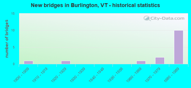
- New bridges - historical statistics
- 11900-1909
- 11920-1929
- 11960-1969
- 21970-1979
- 101980-1989


- Bridge Condition - Deck
- 12.5%Very good
- 50.0%Good
- 25.0%Satisfactory
- 12.5%Fair

- Bridge Condition - Superstructure
- 62.5%Very good
- 12.5%Good
- 25.0%Satisfactory

- Bridge Condition - Substructure
- 25.0%Very good
- 50.0%Good
- 25.0%Satisfactory
Find on map >> Show street view
Structure Number: 100403000204031, Location: 0.18 MI TO JCT W CL2 TH8 (Lat: 44.446397, Lng: -73.217719), Route carried "on" structure: Other road C2007, Year Built: 1966, Year Reconstructed: 1973, Status: Open, Structure Length: 2.47m (8.10ft), Average Daily Traffic: 1,900 (year 2019), Truck Traffic: 20%, Average Future Daily Traffic: 1,995 (year 2029), Design Load: HS 15, Features Intersected: VERMONT RAILWAY
Minimum Vertical Clearance: 30+ m (98+ ft), Kilometerpoint: 0.000, Lanes on structure: 1, Owner: Town or Township Highway Agency, Approaching Roadway Width: 8.5m (27.9ft), Material/Design: Steel, Design/Construction: Stringer/Multi-beam, Number Of Spans In Main Unit: 1, Length of Maximum Span: 24.1m (79.1ft), Curb or Sidewalk Widths: Left: 1.3m (4.3ft), Right: 0.0m, Curb-To-Curb Width: 4.3m (14.1ft), Out-to-Out Width: 5.2m (17.1ft)
Condition: Deck: Satisfactory, Superstructure: Satisfactory, Substructure: Good, Operating Rating: 59.9 metric tons, Method Used To Determine Operating Rating: Allowable Stress (AS), Inventory Rating: 34.5 metric tons, Method Used To Determine Inventory Rating: Allowable Stress (AS), Structural Evaluation: Equal to present minimum criteria, Deck Geometry: High priority of replacement, Underclear: High priority of corrective action, Approach Roadway Alignment: Equal to present desirable criteria, Length Of Structure Improvement: 2.47m (8.10ft), Designated Inspection Frequency: Every 24 months, Inspection Date: September 2021, Bridge Improvement Cost: $488,000, Roadway Improvement Cost: $50,000, Total Project Cost: $538,000 ( Estimate for 2020), Deck Structure Type: Concrete Cast-file-Place, Wearing Surface/Protective System: Wearing Surface: Bituminous
Find on map >> Show street view
Structure Number: 200019001702132, Location: 4.2 MI N EXIT 2 (Lat: 42.947756, Lng: -73.177250), Route carried "on" structure: US 7, Year Built: 1978, Status: Open, Structure Length: 4.69m (15.39ft), Average Daily Traffic: 7,800 (year 2018), Truck Traffic: 9%, Average Future Daily Traffic: 8,190 (year 2028), Design Load: HS 20, Features Intersected: US 7 OVER TH NO 6
Minimum Vertical Clearance: 30+ m (98+ ft), Kilometerpoint: 27.622, Lanes on structure: 3, Lanes under structure: 2, Base Highway Network: Yes, Owner: State Highway Agency, Approaching Roadway Width: 14.0m (45.9ft), Material/Design: Prestressed concrete continuous, Design/Construction: Stringer/Multi-beam, Number Of Spans In Main Unit: 3, Length of Maximum Span: 21.3m (69.9ft), Curb or Sidewalk Widths: Left: 0.2m (0.7ft), Right: 0.2m (0.7ft), Curb-To-Curb Width: 13.6m (44.6ft), Out-to-Out Width: 15.8m (51.8ft)
Condition: Deck: Good, Superstructure: Very good, Substructure: Satisfactory, Operating Rating: 34.5 metric tons, Method Used To Determine Operating Rating: Load Factor (LF), Inventory Rating: 20.9 metric tons, Method Used To Determine Inventory Rating: Load Factor (LF), Structural Evaluation: Somewhat better than minimum adequacy, Deck Geometry: Somewhat better than minimum adequacy, Underclear: Superior to present desirable criteria, Approach Roadway Alignment: Equal to present desirable criteria, Length Of Structure Improvement: 4.69m (15.39ft), Designated Inspection Frequency: Every 24 months, Inspection Date: May 2021, Bridge Improvement Cost: $2,803,000, Roadway Improvement Cost: $50,000, Total Project Cost: $2,853,000 ( Estimate for 2020), Deck Structure Type: Concrete Cast-file-Place, Wearing Surface/Protective System: Wearing Surface: Bituminous, Membrane: Preformed Fabric
Find on map >> Show street view
Structure Number: 200019147A04032, Location: I189 EXIT 1 (Lat: 44.447006, Lng: -73.209386), Route carried "on" structure: US 7, Year Built: 1988, Status: Open, Structure Length: 5.88m (19.29ft), Average Daily Traffic: 39,000 (year 2018), Truck Traffic: 7%, Average Future Daily Traffic: 40,950 (year 2028), Design Load: HS 20+Mod, Features Intersected: US 7 OVER I 189
Minimum Vertical Clearance: 30+ m (98+ ft), Kilometerpoint: 210.858, Lanes on structure: 6, Lanes under structure: 4, Base Highway Network: Yes, Owner: State Highway Agency, Approaching Roadway Width: 23.2m (76.1ft), Skew: 2 degrees, Material/Design: Steel continuous, Design/Construction: Stringer/Multi-beam, Number Of Spans In Main Unit: 2, Length of Maximum Span: 29.0m (95.1ft), Curb or Sidewalk Widths: Left: 1.5m (4.9ft), Right: 1.5m (4.9ft), Curb-To-Curb Width: 25.2m (82.7ft), Out-to-Out Width: 29.1m (95.5ft)
Condition: Deck: Good, Superstructure: Very good, Substructure: Good, Operating Rating: 82.6 metric tons, Method Used To Determine Operating Rating: Load Factor (LF), Inventory Rating: 49.9 metric tons, Method Used To Determine Inventory Rating: Load Factor (LF), Structural Evaluation: Better than present minimum criteria, Deck Geometry: Somewhat better than minimum adequacy, Underclear: Somewhat better than minimum adequacy, Approach Roadway Alignment: Equal to present desirable criteria, Designated Inspection Frequency: Every 24 months, Inspection Date: June 2020, Deck Structure Type: Concrete Cast-file-Place, Wearing Surface/Protective System: Wearing Surface: Bituminous, Membrane: Preformed Fabric, Deck Protection: Epoxy Coated Reinforcing
Find on map >> Show street view
Structure Number: 2004030D1504031, Location: 0.95 MI N JCT NORTH ST (Lat: 44.517592, Lng: -73.241300), Route carried "on" structure: County highway THEHP, Year Built: 1984, Status: Open, Structure Length: 6.80m (22.31ft), Average Daily Traffic: 15,000 (year 2019), Truck Traffic: 6%, Average Future Daily Traffic: 15,750 (year 2029), Design Load: H 20, Features Intersected: E A PKY OVER VT 127, Facility Carried by Structure: ETHAN ALLEN PRKWAY
Minimum Vertical Clearance: 4.64m (15.22ft), Kilometerpoint: 0.000, Lanes on structure: 1, Lanes under structure: 4, Owner: City or Municipal Highway Agency, Approaching Roadway Width: 5.5m (18.0ft), Skew: 2 degrees, Material/Design: Steel continuous, Design/Construction: Stringer/Multi-beam, Number Of Spans In Main Unit: 3, Length of Maximum Span: 45.7m (149.9ft), Curb or Sidewalk Widths: Left: 0.2m (0.7ft), Right: 0.2m (0.7ft), Curb-To-Curb Width: 4.9m (16.1ft), Out-to-Out Width: 5.4m (17.7ft)
Condition: Deck: Good, Superstructure: Very good, Substructure: Very good, Operating Rating: 55.3 metric tons, Method Used To Determine Operating Rating: Allowable Stress (AS), Inventory Rating: 27.2 metric tons, Method Used To Determine Inventory Rating: Allowable Stress (AS), Structural Evaluation: Equal to present minimum criteria, Deck Geometry: High priority of replacement, Underclear: Meets minimum limits, Approach Roadway Alignment: Equal to present desirable criteria, Designated Inspection Frequency: Every 24 months, Inspection Date: July 2020, Deck Structure Type: Concrete Cast-file-Place, Wearing Surface/Protective System: Deck Protection: Epoxy Coated Reinforcing
Find on map >> Show street view
Structure Number: 205000015004032, Location: 0.2 MI S JCT. VT.15 (Lat: 44.489136, Lng: -73.186581), Route carried "on" structure: US 7, Year Built: 1928, Status: Open, Structure Length: 10.94m (35.89ft), Average Daily Traffic: 31,300 (year 2018), Truck Traffic: 7%, Average Future Daily Traffic: 32,865 (year 2028), Design Load: HS 20, Features Intersected: WINOOSKI RIVER
Minimum Vertical Clearance: 30+ m (98+ ft), Kilometerpoint: 217.521, Lanes on structure: 4, Base Highway Network: Yes, Owner: City or Municipal Highway Agency, Approaching Roadway Width: 19.2m (63.0ft), Material/Design: Steel continuous, Design/Construction: Stringer/Multi-beam, Number Of Spans In Main Unit: 3, Length of Maximum Span: 41.1m (134.8ft), Curb or Sidewalk Widths: Left: 1.8m (5.9ft), Right: 1.8m (5.9ft), Curb-To-Curb Width: 12.8m (42.0ft), Out-to-Out Width: 17.6m (57.7ft)
Condition: Deck: Fair, Superstructure: Satisfactory, Substructure: Good, Channel: Very good, Operating Rating: 56.2 metric tons, Method Used To Determine Operating Rating: Allowable Stress (AS), Inventory Rating: 24.5 metric tons, Method Used To Determine Inventory Rating: Allowable Stress (AS), Structural Evaluation: Equal to present minimum criteria, Deck Geometry: High priority of replacement, Waterway Adequacy: Equal to present desirable criteria, Approach Roadway Alignment: Equal to present desirable criteria, Length Of Structure Improvement: 10.94m (35.89ft), Designated Inspection Frequency: Every 24 months, Inspection Date: May 2021, Bridge Improvement Cost: $7,237,000, Roadway Improvement Cost: $50,000, Total Project Cost: $7,287,000 ( Estimate for 2020), Deck Structure Type: Concrete Cast-file-Place, Wearing Surface/Protective System: Wearing Surface: Bituminous, Membrane: Preformed Fabric
Find on map >> Show street view
Structure Number: 205009000104032, Location: 0.31 MI N MANHATTAN DRIVE (Lat: 44.490967, Lng: -73.222847), Route carried "on" structure: City street 127, Year Built: 1971, Status: Open, Structure Length: 2.56m (8.40ft), Average Daily Traffic: 14,800 (year 2016), Truck Traffic: 6%, Average Future Daily Traffic: 15,540 (year 2026), Design Load: HS 20+Mod, Features Intersected: N.E.C.R.R.
Minimum Vertical Clearance: 30+ m (98+ ft), Kilometerpoint: 0.499, Lanes on structure: 2, Base Highway Network: Yes, Owner: City or Municipal Highway Agency, Approaching Roadway Width: 14.0m (45.9ft), Skew: 1 degrees, Material/Design: Steel, Design/Construction: Stringer/Multi-beam, Number Of Spans In Main Unit: 1, Length of Maximum Span: 25.0m (82.0ft), Curb or Sidewalk Widths: Left: 0.2m (0.7ft), Right: 0.2m (0.7ft), Curb-To-Curb Width: 13.4m (44.0ft), Out-to-Out Width: 15.1m (49.5ft)
Condition: Deck: Satisfactory, Superstructure: Good, Substructure: Good, Operating Rating: 89.8 metric tons, Method Used To Determine Operating Rating: Load Factor (LF), Inventory Rating: 58.1 metric tons, Method Used To Determine Inventory Rating: Load Factor (LF), Structural Evaluation: Better than present minimum criteria, Deck Geometry: Equal to present minimum criteria, Underclear: Equal to present minimum criteria, Approach Roadway Alignment: Equal to present desirable criteria, Designated Inspection Frequency: Every 24 months, Inspection Date: July 2020, Deck Structure Type: Other, Wearing Surface/Protective System: Wearing Surface: Bituminous
Find on map >> Show street view
Structure Number: 205009000504032, Location: 3.43 MI N MANHATTAN DRIVE (Lat: 44.524889, Lng: -73.255425), Route carried "on" structure: City street 127, Year Built: 1983, Status: Open, Structure Length: 20.73m (68.01ft), Average Daily Traffic: 14,800 (year 2016), Truck Traffic: 7%, Average Future Daily Traffic: 15,540 (year 2026), Design Load: HS 25 or greater, Features Intersected: WINOOSKI RIVER
Minimum Vertical Clearance: 30+ m (98+ ft), Kilometerpoint: 0.000, Lanes on structure: 2, Base Highway Network: Yes, Owner: City or Municipal Highway Agency, Approaching Roadway Width: 12.8m (42.0ft), Material/Design: Steel continuous, Design/Construction: Stringer/Multi-beam, Number Of Spans In Main Unit: 3, Length of Maximum Span: 79.2m (259.8ft), Curb or Sidewalk Widths: Left: 0.2m (0.7ft), Right: 2.5m (8.2ft), Curb-To-Curb Width: 13.0m (42.7ft), Out-to-Out Width: 16.8m (55.1ft)
Condition: Deck: Good, Superstructure: Very good, Substructure: Very good, Channel: Very good, Operating Rating: 89.8 metric tons, Method Used To Determine Operating Rating: Load Factor (LF), Inventory Rating: 89.8 metric tons, Method Used To Determine Inventory Rating: Load Factor (LF), Structural Evaluation: Equal to present desirable criteria, Deck Geometry: Somewhat better than minimum adequacy, Waterway Adequacy: Equal to present desirable criteria, Approach Roadway Alignment: Equal to present desirable criteria, Designated Inspection Frequency: Every 24 months, Inspection Date: July 2020, Deck Structure Type: Concrete Cast-file-Place, Wearing Surface/Protective System: Wearing Surface: Bituminous, Membrane: Preformed Fabric, Deck Protection: Epoxy Coated Reinforcing
Find on map >> Show street view
Structure Number: 2050270D1204032, Location: NORTH AVE. INTERCHANGE (Lat: 44.502208, Lng: -73.230758), Route carried "on" structure: City street TH11, Year Built: 1984, Status: Open, Structure Length: 4.02m (13.19ft), Average Daily Traffic: 5,000 (year 2019), Truck Traffic: 2%, Average Future Daily Traffic: 5,250 (year 2029), Design Load: HS 25 or greater, Features Intersected: FAU TH11 OVER VT127
Minimum Vertical Clearance: 30+ m (98+ ft), Kilometerpoint: 0.000, Lanes on structure: 2, Lanes under structure: 5, Base Highway Network: Yes, Owner: City or Municipal Highway Agency, Approaching Roadway Width: 12.2m (40.0ft), Skew: 20 degrees, Material/Design: Steel, Design/Construction: Stringer/Multi-beam, Number Of Spans In Main Unit: 1, Length of Maximum Span: 39.0m (128.0ft), Curb or Sidewalk Widths: Left: 0.2m (0.7ft), Right: 0.2m (0.7ft), Curb-To-Curb Width: 16.7m (54.8ft), Out-to-Out Width: 17.9m (58.7ft)
Condition: Deck: Very good, Superstructure: Very good, Substructure: Satisfactory, Operating Rating: 89.8 metric tons, Method Used To Determine Operating Rating: Allowable Stress (AS), Inventory Rating: 45.4 metric tons, Method Used To Determine Inventory Rating: Allowable Stress (AS), Structural Evaluation: Equal to present minimum criteria, Deck Geometry: Superior to present desirable criteria, Underclear: High priority of corrective action, Approach Roadway Alignment: Equal to present desirable criteria, Designated Inspection Frequency: Every 24 months, Inspection Date: July 2020, Deck Structure Type: Concrete Cast-file-Place, Wearing Surface/Protective System: Wearing Surface: Bituminous, Membrane: Preformed Fabric, Deck Protection: Epoxy Coated Reinforcing
Find on map >> Show street view
Structure Number: 100403001104031, Location: 0.1 MI TO JCT W PINE ST. (Lat: 44.461228, Lng: -73.218733), Route carried "under" structure: Other road C3LAK, Year Built: 1909, Structure Length: 0. m, Average Daily Traffic: 2,000 (year 1999), Truck Traffic: 2%, Features Intersected: VERMONT RAILWAY, Facility Carried by Structure: RAILROAD
Kilometerpoint: 0.000, Material/Design: Steel, Design/Construction: Stringer/Multi-beam, Length of Maximum Span: 7.9m (25.9ft)
Find on map >> Show street view
Structure Number: 100403001604031, Location: 0.11 MI TO JCT W PINE ST (Lat: 44.461236, Lng: -73.218797), Route carried "under" structure: Other road C3LAK, Year Built: 1988, Structure Length: 0. m, Average Daily Traffic: 2,000 (year 1999), Truck Traffic: 2%, Features Intersected: BURLINGTON BIKEPATH, Facility Carried by Structure: PEDESTRIAN
Kilometerpoint: 0.000, Material/Design: Steel, Design/Construction: Truss - Thru, Length of Maximum Span: 21.0m (68.9ft)
Find on map >> Show street view
Structure Number: 200019147A04032, Location: I189 EXIT 1 (Lat: 44.447006, Lng: -73.209386), Route carried "under" structure: Spur Interstate 189, Year Built: 1988, Structure Length: 0. m, Average Daily Traffic: 39,100 (year 1998), Truck Traffic: 8%, Features Intersected: I189 UNDER US 7, Facility Carried by Structure: US 00007 ML
Minimum Vertical Clearance: 5.10m (16.73ft), Kilometerpoint: 0.132, Lanes on structure: 6, Material/Design: Steel continuous, Design/Construction: Stringer/Multi-beam, Length of Maximum Span: 29.0m (95.1ft)
Find on map >> Show street view
Structure Number: 2004030D1504031, Location: 0.95 MI N JCT NORTH ST (Lat: 44.517592, Lng: -73.241300), Route carried "under" structure: City street 127, Year Built: 1984, Structure Length: 0. m, Average Daily Traffic: 9,100 (year 1997), Truck Traffic: 10%, Features Intersected: E A PKY OVER VT 127, Facility Carried by Structure: ETHAN ALLEN PRKWAY
Minimum Vertical Clearance: 4.64m (15.22ft), Kilometerpoint: 3.765, Lanes on structure: 1, Material/Design: Steel continuous, Design/Construction: Stringer/Multi-beam, Length of Maximum Span: 45.7m (149.9ft)
Find on map >> Show street view
Structure Number: 205009001304032, Location: 1.43 MI N MANHATTAN DRIVE (Lat: 44.505219, Lng: -73.232906), Route carried "under" structure: City street 127, Year Built: 1984, Structure Length: 0. m, Average Daily Traffic: 9,100 (year 1997), Truck Traffic: 10%, Features Intersected: PED BRG OVER VT127, Facility Carried by Structure: PEDESTRIAN
Kilometerpoint: 2.333, Material/Design: Wood or Timber, Design/Construction: Arch - Thru, Length of Maximum Span: 42.7m (140.1ft)
Find on map >> Show street view
Structure Number: 205009001404032, Location: 2.14 MI N MANHATTAN DRIVE (Lat: 44.514783, Lng: -73.236200), Route carried "under" structure: City street 127, Year Built: 1984, Structure Length: 0. m, Average Daily Traffic: 9,100 (year 1997), Truck Traffic: 10%, Features Intersected: BIKE PATH OVER VT127, Facility Carried by Structure: PEDESTRIAN
Kilometerpoint: 3.443, Material/Design: Steel, Design/Construction: Suspension, Length of Maximum Span: 38.7m (127.0ft)
Find on map >> Show street view
Structure Number: 2050270D1204032, Location: NORTH AVE. INTERCHANGE (Lat: 44.502208, Lng: -73.230758), Route carried "under" structure: City street 127, Year Built: 1984, Structure Length: 0. m, Average Daily Traffic: 12,950 (year 1997), Truck Traffic: 10%, Features Intersected: FAU TH 11 OVER VT 127, Facility Carried by Structure: FAU TH11
Minimum Vertical Clearance: 5.18m (16.99ft), Kilometerpoint: 1.899, Lanes on structure: 2, Material/Design: Steel, Design/Construction: Stringer/Multi-beam, Length of Maximum Span: 39.0m (128.0ft)