Bridge Statistics for Burke, Virginia (VA)
Condition, Traffic, Stress, Structural Evaluation, Project Costs
- National Bridge Inventory (NBI) Statistics
- 17Number of bridges
- 128ft / 39.2mTotal length
- $6,175,000Total costs
- 164,533Total average daily traffic
- 1,853Total average daily truck traffic
- National Bridge Inventory (NBI) Registered Bridges for Burke
- No street view available for this location
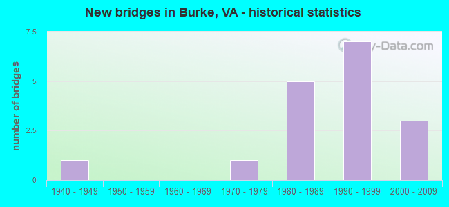
- New bridges - historical statistics
- 11940-1949
- 11970-1979
- 51980-1989
- 71990-1999
- 32000-2009


- Bridge Condition - Deck
- 62.5%Good
- 25.0%Satisfactory
- 12.5%Fair

- Bridge Condition - Superstructure
- 62.5%Good
- 37.5%Satisfactory

- Bridge Condition - Substructure
- 50.0%Good
- 37.5%Satisfactory
- 12.5%Fair

- Bridge Condition - Channel
- 20.0%Good
- 60.0%Satisfactory
- 20.0%Fair
Find on map >> Show street view
Structure Number: 6449, Location: 00.13FR643/00.18TO660 (Lat: 38.800431, Lng: -77.325517), Route carried "on" structure: State highway 123, Year Built: 1948, Status: Open, Structure Length: 5.64m (18.50ft), Average Daily Traffic: 13,391 (year 2020), Truck Traffic: 2%, Average Future Daily Traffic: 18,749 (year 2040), Design Load: HS 20+Mod, Features Intersected: NS RAILWAY, Facility Carried by Structure: OX ROAD
Minimum Vertical Clearance: 30+ m (98+ ft), Kilometerpoint: 18.471, Lanes on structure: 2, Base Highway Network: Yes, Owner: State Highway Agency, Approaching Roadway Width: 9.1m (29.9ft), Material/Design: Steel continuous, Design/Construction: Stringer/Multi-beam, Number Of Spans In Main Unit: 3, Length of Maximum Span: 21.3m (69.9ft), Curb-To-Curb Width: 8.7m (28.5ft), Out-to-Out Width: 9.4m (30.8ft)
Condition: Deck: Fair, Superstructure: Satisfactory, Substructure: Fair, Operating Rating: 60.8 metric tons, Method Used To Determine Operating Rating: Load and Resistance Factor (LRFR), Inventory Rating: 47.2 metric tons, Method Used To Determine Inventory Rating: Load and Resistance Factor (LRFR), Structural Evaluation: Somewhat better than minimum adequacy, Deck Geometry: High priority of corrective action, Underclear: Superior to present desirable criteria, Approach Roadway Alignment: Equal to present desirable criteria, Length Of Structure Improvement: 4.88m (16.01ft), Designated Inspection Frequency: Every 24 months, Inspection Date: March 2020, Bridge Improvement Cost: $137,000, Roadway Improvement Cost: $5,000, Total Project Cost: $145,000 ( Estimate for 2014), Deck Structure Type: Concrete Cast-file-Place, Wearing Surface/Protective System: Wearing Surface: Monolithic Concrete, Deck Protection: Epoxy Coated Reinforcing
Find on map >> Show street view
Structure Number: 6454, Location: 00.13FR643/00.18TO660 (Lat: 38.800492, Lng: -77.325289), Route carried "on" structure: State highway 123, Year Built: 1985, Status: Open, Structure Length: 4.85m (15.91ft), Average Daily Traffic: 13,391 (year 2020), Truck Traffic: 2%, Average Future Daily Traffic: 18,749 (year 2040), Design Load: HS 20+Mod, Features Intersected: NS RAILWAY, Facility Carried by Structure: OX ROAD
Minimum Vertical Clearance: 30+ m (98+ ft), Kilometerpoint: 18.471, Lanes on structure: 2, Base Highway Network: Yes, Owner: State Highway Agency, Approaching Roadway Width: 12.8m (42.0ft), Material/Design: Steel, Design/Construction: Stringer/Multi-beam, Number Of Spans In Main Unit: 3, Length of Maximum Span: 21.3m (69.9ft), Curb or Sidewalk Widths: Left: 0.0m, Right: 2.7m (8.9ft), Curb-To-Curb Width: 11.7m (38.4ft), Out-to-Out Width: 15.8m (51.8ft)
Condition: Deck: Satisfactory, Superstructure: Satisfactory, Substructure: Satisfactory, Operating Rating: 89.8 metric tons, Method Used To Determine Operating Rating: Load and Resistance Factor (LRFR), Inventory Rating: 89.8 metric tons, Method Used To Determine Inventory Rating: Load and Resistance Factor (LRFR), Structural Evaluation: Equal to present minimum criteria, Deck Geometry: Better than present minimum criteria, Underclear: Superior to present desirable criteria, Approach Roadway Alignment: Equal to present desirable criteria, Length Of Structure Improvement: 4.85m (15.91ft), Designated Inspection Frequency: Every 24 months, Inspection Date: March 2020, Bridge Improvement Cost: $25,000, Roadway Improvement Cost: $1,000, Total Project Cost: $27,000 ( Estimate for 2014), Deck Structure Type: Concrete Precast Panels, Wearing Surface/Protective System: Wearing Surface: Monolithic Concrete, Deck Protection: Epoxy Coated Reinforcing
Find on map >> Show street view
Structure Number: 6737, Location: 00.10 7501 / 00.05 7523 (Lat: 38.752953, Lng: -77.244333), Route carried "on" structure: County highway 636, Year Built: 1980, Status: Open, Structure Length: 0.98m (3.22ft), Average Daily Traffic: 1,778 (year 2020), Truck Traffic: 3%, Average Future Daily Traffic: 1,956 (year 2040), Design Load: HS 20+Mod, Features Intersected: MIDDLE RUN, Facility Carried by Structure: HOOES ROAD
Minimum Vertical Clearance: 30+ m (98+ ft), Kilometerpoint: 5.899, Lanes on structure: 2, Owner: State Highway Agency, Approaching Roadway Width: 11.0m (36.1ft), Material/Design: Concrete, Design/Construction: Culvert, Number Of Spans In Main Unit: 3, Length of Maximum Span: 3.0m (9.8ft)
Condition: Channel: Fair, Culverts: Good, Operating Rating: 64.4 metric tons, Method Used To Determine Operating Rating: Field evaluation and documented engineering judgment, Inventory Rating: 38.1 metric tons, Method Used To Determine Inventory Rating: Field evaluation and documented engineering judgment, Structural Evaluation: Better than present minimum criteria, Waterway Adequacy: Somewhat better than minimum adequacy, Approach Roadway Alignment: Better than present minimum criteria, Length Of Structure Improvement: 0.30m (0.98ft), Designated Inspection Frequency: Every 24 months, Inspection Date: April 2021, Bridge Improvement Cost: $1,000, Roadway Improvement Cost: $2,000, Total Project Cost: $4,000 ( Estimate for 2017)
Find on map >> Show street view
Structure Number: 6755, Location: 00.15FR1031/00.15TO4521 (Lat: 38.775011, Lng: -77.246022), Route carried "on" structure: County highway 644, Year Built: 1974, Status: Open, Structure Length: 3.74m (12.27ft), Average Daily Traffic: 28,201 (year 2020), Truck Traffic: 2%, Average Future Daily Traffic: 31,220 (year 2040), Design Load: HS 20, Features Intersected: POHICK CREEK, Facility Carried by Structure: OLD KEENE MILL RD.
Minimum Vertical Clearance: 30+ m (98+ ft), Kilometerpoint: 4.103, Lanes on structure: 4, Owner: State Highway Agency, Approaching Roadway Width: 14.0m (45.9ft), Skew: 21 degrees, Material/Design: Steel, Design/Construction: Stringer/Multi-beam, Number Of Spans In Main Unit: 3, Length of Maximum Span: 12.2m (40.0ft), Curb or Sidewalk Widths: Left: 1.5m (4.9ft), Right: 1.5m (4.9ft), Curb-To-Curb Width: 15.2m (49.9ft), Out-to-Out Width: 25.8m (84.6ft)
Condition: Deck: Good, Superstructure: Satisfactory, Substructure: Good, Channel: Good, Operating Rating: 90.6 metric tons, Method Used To Determine Operating Rating: Load and Resistance Factor (LRFR), Inventory Rating: 69.9 metric tons, Method Used To Determine Inventory Rating: Load and Resistance Factor (LRFR), Structural Evaluation: Equal to present minimum criteria, Deck Geometry: High priority of corrective action, Waterway Adequacy: Equal to present desirable criteria, Approach Roadway Alignment: Equal to present desirable criteria, Length Of Structure Improvement: 3.66m (12.01ft), Designated Inspection Frequency: Every 24 months, Inspection Date: May 2021, Bridge Improvement Cost: $100,000, Roadway Improvement Cost: $77,000, Total Project Cost: $250,000, Deck Structure Type: Concrete Cast-file-Place, Wearing Surface/Protective System: Wearing Surface: Latex Concrete
Find on map >> Show street view
Structure Number: 6761, Location: 00.10FR652/00.08TO5847 (Lat: 38.792400, Lng: -77.273400), Route carried "on" structure: County highway 645, Year Built: 1986, Status: Open, Structure Length: 2.68m (8.79ft), Average Daily Traffic: 25,771 (year 2020), Truck Traffic: 2%, Average Future Daily Traffic: 36,079 (year 2040), Design Load: HS 20, Features Intersected: POHICK CREEK, Facility Carried by Structure: BURKE LAKE ROAD
Minimum Vertical Clearance: 30+ m (98+ ft), Kilometerpoint: 30.523, Lanes on structure: 4, Owner: State Highway Agency, Approaching Roadway Width: 16.5m (54.1ft), Skew: 20 degrees, Material/Design: Steel, Design/Construction: Stringer/Multi-beam, Number Of Spans In Main Unit: 1, Length of Maximum Span: 26.8m (87.9ft), Curb or Sidewalk Widths: Left: 2.7m (8.9ft), Right: 2.7m (8.9ft), Curb-To-Curb Width: 16.5m (54.1ft), Out-to-Out Width: 27.4m (89.9ft)
Condition: Deck: Good, Superstructure: Good, Substructure: Satisfactory, Channel: Satisfactory, Operating Rating: 85.3 metric tons, Method Used To Determine Operating Rating: Load and Resistance Factor (LRFR), Inventory Rating: 65.3 metric tons, Method Used To Determine Inventory Rating: Load and Resistance Factor (LRFR), Structural Evaluation: Equal to present minimum criteria, Deck Geometry: Meets minimum limits, Waterway Adequacy: Better than present minimum criteria, Approach Roadway Alignment: Equal to present desirable criteria, Length Of Structure Improvement: 2.68m (8.79ft), Designated Inspection Frequency: Every 24 months, Inspection Date: May 2020, Bridge Improvement Cost: $100,000, Roadway Improvement Cost: $20,000, Total Project Cost: $125,000, Deck Structure Type: Concrete Cast-file-Place, Wearing Surface/Protective System: Deck Protection: Epoxy Coated Reinforcing
Find on map >> Show street view
Structure Number: 677, Location: 00.10FR652/00.55TO5101 (Lat: 38.796511, Lng: -77.272744), Route carried "on" structure: County highway 645, Year Built: 1987, Status: Open, Structure Length: 3.96m (12.99ft), Average Daily Traffic: 25,771 (year 2020), Average Future Daily Traffic: 36,079 (year 2040), Design Load: HS 20, Features Intersected: SOUTHERN RAILWAY., Facility Carried by Structure: BURKE LAKE ROAD
Minimum Vertical Clearance: 30+ m (98+ ft), Kilometerpoint: 30.838, Lanes on structure: 5, Owner: State Highway Agency, Approaching Roadway Width: 26.8m (87.9ft), Skew: 20 degrees, Material/Design: Steel, Design/Construction: Stringer/Multi-beam, Number Of Spans In Main Unit: 2, Length of Maximum Span: 21.6m (70.9ft), Curb or Sidewalk Widths: Left: 2.7m (8.9ft), Right: 2.7m (8.9ft), Curb-To-Curb Width: 20.1m (65.9ft), Out-to-Out Width: 27.4m (89.9ft)
Condition: Deck: Satisfactory, Superstructure: Good, Substructure: Satisfactory, Operating Rating: 80.7 metric tons, Method Used To Determine Operating Rating: Load and Resistance Factor (LRFR), Inventory Rating: 61.7 metric tons, Method Used To Determine Inventory Rating: Load and Resistance Factor (LRFR), Structural Evaluation: Equal to present minimum criteria, Deck Geometry: Somewhat better than minimum adequacy, Underclear: Superior to present desirable criteria, Approach Roadway Alignment: Equal to present desirable criteria, Length Of Structure Improvement: 3.96m (12.99ft), Designated Inspection Frequency: Every 24 months, Inspection Date: June 2021, Bridge Improvement Cost: $55,000, Roadway Improvement Cost: $120,000, Total Project Cost: $199,000, Deck Structure Type: Concrete Cast-file-Place, Wearing Surface/Protective System: Wearing Surface: Monolithic Concrete, Deck Protection: Epoxy Coated Reinforcing
Find on map >> Show street view
Structure Number: 6999, Location: 00.15FR4582 / 00.20TO4504 (Lat: 38.764514, Lng: -77.266731), Route carried "on" structure: County highway 4592, Year Built: 1980, Status: Open, Structure Length: 0.85m (2.79ft), Average Daily Traffic: 1,093 (year 2019), Average Future Daily Traffic: 1,208 (year 2040), Design Load: HS 20+Mod, Features Intersected: CHERRY RUN, Facility Carried by Structure: COTTTONTAIL COURT
Minimum Vertical Clearance: 30+ m (98+ ft), Kilometerpoint: 0.434, Lanes on structure: 2, Owner: State Highway Agency, Approaching Roadway Width: 11.0m (36.1ft), Skew: 3 degrees, Material/Design: Concrete, Design/Construction: Culvert, Number Of Spans In Main Unit: 3, Length of Maximum Span: 2.7m (8.9ft)
Condition: Channel: Satisfactory, Culverts: Good, Operating Rating: 89.8 metric tons, Method Used To Determine Operating Rating: Load Factor (LF), Inventory Rating: 64.4 metric tons, Method Used To Determine Inventory Rating: Load Factor (LF), Structural Evaluation: Better than present minimum criteria, Waterway Adequacy: Somewhat better than minimum adequacy, Approach Roadway Alignment: Equal to present desirable criteria, Designated Inspection Frequency: Every 24 months, Inspection Date: Febuary 2021
Find on map >> Show street view
Structure Number: 23472, Location: 00.02FR6911/00.38TO4551 (Lat: 38.755906, Lng: -77.236986), Route carried "on" structure: County highway 640, Year Built: 1992, Status: Open, Structure Length: 4.05m (13.29ft), Average Daily Traffic: 4,579 (year 2020), Truck Traffic: 2%, Average Future Daily Traffic: 4,948 (year 2040), Design Load: HS 20, Features Intersected: FAIRFAX COUNTY PKWY., Facility Carried by Structure: SYDENSTRICKER RD.
Minimum Vertical Clearance: 30+ m (98+ ft), Kilometerpoint: 3.492, Lanes on structure: 4, Lanes under structure: 4, Owner: State Highway Agency, Approaching Roadway Width: 18.9m (62.0ft), Material/Design: Steel, Design/Construction: Stringer/Multi-beam, Number Of Spans In Main Unit: 1, Length of Maximum Span: 39.9m (130.9ft), Curb-To-Curb Width: 22.1m (72.5ft), Out-to-Out Width: 23.1m (75.8ft)
Condition: Deck: Good, Superstructure: Good, Substructure: Good, Operating Rating: 42.6 metric tons, Method Used To Determine Operating Rating: Load and Resistance Factor (LRFR), Inventory Rating: 32.9 metric tons, Method Used To Determine Inventory Rating: Load and Resistance Factor (LRFR), Structural Evaluation: Better than present minimum criteria, Deck Geometry: Superior to present desirable criteria, Underclear: Equal to present minimum criteria, Approach Roadway Alignment: Equal to present desirable criteria, Length Of Structure Improvement: 4.05m (13.29ft), Designated Inspection Frequency: Every 24 months, Inspection Date: April 2020, Bridge Improvement Cost: $44,000, Roadway Improvement Cost: $99,000, Total Project Cost: $150,000 ( Estimate for 2014), Deck Structure Type: Concrete Cast-file-Place, Wearing Surface/Protective System: Wearing Surface: Monolithic Concrete, Deck Protection: Epoxy Coated Reinforcing
Find on map >> Show street view
Structure Number: 23473, Location: 00.28FR6997/00.01TO0000 (Lat: 38.757022, Lng: -77.233228), Route carried "on" structure: County highway 640, Year Built: 1992, Status: Open, Structure Length: 4.02m (13.19ft), Average Daily Traffic: 4,829 (year 2020), Truck Traffic: 2%, Average Future Daily Traffic: 5,312 (year 2040), Design Load: HS 20, Features Intersected: FAIRFAX CO. PKWY., Facility Carried by Structure: GAMBRILL ROAD
Minimum Vertical Clearance: 4.82m (15.81ft), Kilometerpoint: 3.974, Lanes on structure: 4, Lanes under structure: 4, Owner: State Highway Agency, Approaching Roadway Width: 16.8m (55.1ft), Material/Design: Steel, Design/Construction: Stringer/Multi-beam, Number Of Spans In Main Unit: 1, Length of Maximum Span: 39.6m (129.9ft), Curb or Sidewalk Widths: Left: 0.0m, Right: 2.6m (8.5ft), Curb-To-Curb Width: 15.8m (51.8ft), Out-to-Out Width: 19.4m (63.6ft)
Condition: Deck: Good, Superstructure: Good, Substructure: Good, Operating Rating: 41.5 metric tons, Method Used To Determine Operating Rating: Load and Resistance Factor (LRFR), Inventory Rating: 32.0 metric tons, Method Used To Determine Inventory Rating: Load and Resistance Factor (LRFR), Structural Evaluation: Better than present minimum criteria, Deck Geometry: Meets minimum limits, Underclear: Equal to present minimum criteria, Approach Roadway Alignment: Equal to present desirable criteria, Length Of Structure Improvement: 1.52m (4.99ft), Designated Inspection Frequency: Every 24 months, Inspection Date: October 2020, Bridge Improvement Cost: $100,000, Roadway Improvement Cost: $100,000, Total Project Cost: $210,000 ( Estimate for 2014), Deck Structure Type: Concrete Cast-file-Place, Wearing Surface/Protective System: Wearing Surface: Monolithic Concrete, Deck Protection: Epoxy Coated Reinforcing
Find on map >> Show street view
Structure Number: 23789, Location: 00.08FR1583/00.22TO0000 (Lat: 38.752808, Lng: -77.247478), Route carried "on" structure: County highway 7516, Year Built: 1990, Status: Open, Structure Length: 0.98m (3.22ft), Average Daily Traffic: 2,224 (year 2001), Average Future Daily Traffic: 2,658 (year 2040), Design Load: HS 20+Mod, Features Intersected: MIDDLE RUN, Facility Carried by Structure: THORNCLIFF LANE
Minimum Vertical Clearance: 30+ m (98+ ft), Kilometerpoint: 0.000, Lanes on structure: 2, Owner: State Highway Agency, Approaching Roadway Width: 11.6m (38.1ft), Skew: 2 degrees, Material/Design: Concrete, Design/Construction: Culvert, Number Of Spans In Main Unit: 3, Length of Maximum Span: 3.0m (9.8ft)
Condition: Channel: Satisfactory, Culverts: Good, Operating Rating: 89.8 metric tons, Method Used To Determine Operating Rating: Load Factor (LF), Inventory Rating: 78.0 metric tons, Method Used To Determine Inventory Rating: Load Factor (LF), Structural Evaluation: Better than present minimum criteria, Waterway Adequacy: Better than present minimum criteria, Approach Roadway Alignment: Equal to present desirable criteria, Length Of Structure Improvement: 9.69m (31.79ft), Designated Inspection Frequency: Every 24 months, Inspection Date: June 2020, Bridge Improvement Cost: $12,000, Roadway Improvement Cost: $35,000, Total Project Cost: $55,000
Find on map >> Show street view
Structure Number: 25218, Location: 0.7 FR 643 & 0.2 TO 651 (Lat: 38.797269, Lng: -77.302381), Route carried "on" structure: County highway 6197, Year Built: 2001, Status: Open, Structure Length: 7.47m (24.51ft), Average Daily Traffic: 13,105 (year 2020), Average Future Daily Traffic: 18,347 (year 2040), Design Load: HS 20, Features Intersected: NS RAILWAY, Facility Carried by Structure: ROBERTS PARKWAY
Minimum Vertical Clearance: 30+ m (98+ ft), Kilometerpoint: 1.947, Lanes on structure: 4, Lanes under structure: 4, Owner: State Highway Agency, Approaching Roadway Width: 26.8m (87.9ft), Skew: 21 degrees, Material/Design: Steel, Design/Construction: Stringer/Multi-beam, Number Of Spans In Main Unit: 2, Length of Maximum Span: 36.9m (121.1ft), Curb or Sidewalk Widths: Left: 2.1m (6.9ft), Right: 3.0m (9.8ft), Curb-To-Curb Width: 16.2m (53.1ft), Out-to-Out Width: 27.6m (90.6ft)
Condition: Deck: Good, Superstructure: Good, Substructure: Good, Operating Rating: 68.9 metric tons, Method Used To Determine Operating Rating: Load and Resistance Factor (LRFR), Inventory Rating: 52.6 metric tons, Method Used To Determine Inventory Rating: Load and Resistance Factor (LRFR), Structural Evaluation: Better than present minimum criteria, Deck Geometry: Meets minimum limits, Underclear: High priority of replacement, Approach Roadway Alignment: Better than present minimum criteria, Length Of Structure Improvement: 7.47m (24.51ft), Designated Inspection Frequency: Every 24 months, Inspection Date: September 2021, Bridge Improvement Cost: $200,000, Roadway Improvement Cost: $4,800,000, Total Project Cost: $5,010,000, Deck Structure Type: Concrete Cast-file-Place, Wearing Surface/Protective System: Wearing Surface: Monolithic Concrete, Deck Protection: Epoxy Coated Reinforcing
Find on map >> Show street view
Structure Number: 23472, Location: 00.02FR6911/00.38TO4551 (Lat: 38.755906, Lng: -77.236986), Route carried "under" structure: County highway 286, Year Built: 1992, Structure Length: 0. m, Average Daily Traffic: 5,000 (year 1994), Features Intersected: FAIRFAX COUNTY PKWY., Facility Carried by Structure: SYDENSTRICKER RD.
Minimum Vertical Clearance: 5.28m (17.32ft), Kilometerpoint: 0.000, Lanes on structure: 4, Lanes under structure: 2, Material/Design: Steel, Design/Construction: Stringer/Multi-beam, Length of Maximum Span: 39.9m (130.9ft)
Find on map >> Show street view
Structure Number: 23472, Location: 00.02FR6911/00.38TO4551 (Lat: 38.755906, Lng: -77.236986), Route carried "under" structure: County highway 286, Year Built: 1992, Structure Length: 0. m, Average Daily Traffic: 5,000 (year 1994), Features Intersected: FAIRFAX COUNTY PKWY., Facility Carried by Structure: SYDENSTRICKER RD.
Minimum Vertical Clearance: 6.17m (20.24ft), Kilometerpoint: 0.000, Lanes on structure: 4, Lanes under structure: 2, Material/Design: Steel, Design/Construction: Stringer/Multi-beam, Length of Maximum Span: 39.9m (130.9ft)
Find on map >> Show street view
Structure Number: 23473, Location: 00.28FR6997/00.01TO0000 (Lat: 38.757022, Lng: -77.233228), Route carried "under" structure: County highway 286, Year Built: 1992, Structure Length: 0. m, Average Daily Traffic: 10,000 (year 1994), Features Intersected: FAIRFAX CO. PKWY., Facility Carried by Structure: GAMBRILL ROAD
Minimum Vertical Clearance: 6.27m (20.57ft), Kilometerpoint: 0.000, Lanes on structure: 4, Lanes under structure: 2, Material/Design: Steel, Design/Construction: Stringer/Multi-beam, Length of Maximum Span: 39.6m (129.9ft)
Find on map >> Show street view
Structure Number: 23473, Location: 00.28FR6997/00.01TO0000 (Lat: 38.757022, Lng: -77.233228), Route carried "under" structure: County highway 286, Year Built: 1992, Structure Length: 0. m, Average Daily Traffic: 10,000 (year 1994), Features Intersected: FAIRFAX CO. PKWY., Facility Carried by Structure: GAMBRILL ROAD
Minimum Vertical Clearance: 5.69m (18.67ft), Kilometerpoint: 0.000, Lanes on structure: 4, Lanes under structure: 2, Material/Design: Steel, Design/Construction: Stringer/Multi-beam, Length of Maximum Span: 39.6m (129.9ft)
Find on map >> Show street view
Structure Number: 25218, Location: 0.7 FR 643 & 0.2 TO 651 (Lat: 38.797269, Lng: -77.302381), Route carried "under" structure: County highway , Year Built: 2001, Structure Length: 0. m, Average Daily Traffic: 200 (year 2003), Features Intersected: NS RAILWAY, Facility Carried by Structure: ROBERTS PARKWAY
Minimum Vertical Clearance: 10.54m (34.58ft), Kilometerpoint: 0.000, Lanes on structure: 4, Lanes under structure: 2, Material/Design: Steel, Design/Construction: Stringer/Multi-beam, Length of Maximum Span: 36.9m (121.1ft)
Find on map >> Show street view
Structure Number: 25218, Location: 0.7 FR 643 & 0.2 TO 651 (Lat: 38.797269, Lng: -77.302381), Route carried "under" structure: Other road , Year Built: 2001, Structure Length: 0. m, Average Daily Traffic: 200 (year 2003), Features Intersected: NS RAILWAY, Facility Carried by Structure: ROBERTS PARKWAY
Minimum Vertical Clearance: 7.11m (23.33ft), Kilometerpoint: 0.000, Lanes on structure: 4, Lanes under structure: 2, Material/Design: Steel, Design/Construction: Stringer/Multi-beam, Length of Maximum Span: 36.9m (121.1ft)