Bridge Statistics for Bull Run, Virginia (VA)
Condition, Traffic, Stress, Structural Evaluation, Project Costs
- National Bridge Inventory (NBI) Statistics
- 27Number of bridges
- 177ft / 53.5mTotal length
- $2,167,000Total costs
- 659,205Total average daily traffic
- 39,094Total average daily truck traffic
- National Bridge Inventory (NBI) Registered Bridges for Bull Run
- No street view available for this location
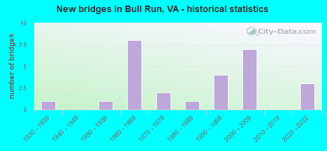
- New bridges - historical statistics
- 11930-1939
- 11950-1959
- 81960-1969
- 21970-1979
- 11980-1989
- 41990-1999
- 72000-2009
- 32020-2022


- Bridge Condition - Deck
- 9.1%Very good
- 63.6%Good
- 18.2%Satisfactory
- 9.1%Fair

- Bridge Condition - Superstructure
- 18.2%Very good
- 45.5%Good
- 27.3%Satisfactory
- 9.1%Fair

- Bridge Condition - Substructure
- 9.1%Very good
- 36.4%Good
- 36.4%Satisfactory
- 18.2%Fair

- Bridge Condition - Channel
- 23.1%Very good
- 7.7%Good
- 30.8%Satisfactory
- 38.5%Fair

- Bridge Condition - Culverts
- 50.0%Good
- 50.0%Satisfactory
Find on map >> Show street view
Structure Number: 14196, Location: 00.30FR622/00.97TO234 (Lat: 38.814039, Lng: -77.543947), Route carried "on" structure: US 29, Year Built: 1935, Status: Open, Structure Length: 0.78m (2.56ft), Average Daily Traffic: 20,527 (year 2020), Truck Traffic: 1%, Average Future Daily Traffic: 22,580 (year 2040), Design Load: HS 20, Features Intersected: DOGANS BRANCH, Facility Carried by Structure: LEE HIGHWAY
Minimum Vertical Clearance: 30+ m (98+ ft), Kilometerpoint: 355.798, Lanes on structure: 2, Base Highway Network: Yes, Owner: State Highway Agency, Approaching Roadway Width: 7.0m (23.0ft), Skew: 4 degrees, Material/Design: Concrete, Design/Construction: Slab, Number Of Spans In Main Unit: 1, Length of Maximum Span: 5.5m (18.0ft), Curb or Sidewalk Widths: Left: 0.2m (0.7ft), Right: 0.2m (0.7ft), Curb-To-Curb Width: 11.7m (38.4ft), Out-to-Out Width: 12.8m (42.0ft)
Condition: Deck: Fair, Superstructure: Fair, Substructure: Satisfactory, Channel: Satisfactory, Operating Rating: 36.3 metric tons, Method Used To Determine Operating Rating: Load and Resistance Factor (LRFR), Inventory Rating: 28.1 metric tons, Method Used To Determine Inventory Rating: Load and Resistance Factor (LRFR), Structural Evaluation: Somewhat better than minimum adequacy, Deck Geometry: Somewhat better than minimum adequacy, Waterway Adequacy: Equal to present desirable criteria, Approach Roadway Alignment: Equal to present desirable criteria, Length Of Structure Improvement: 0.55m (1.80ft), Designated Inspection Frequency: Every 24 months, Inspection Date: June 2021, Bridge Improvement Cost: $66,000, Roadway Improvement Cost: $120,000, Total Project Cost: $200,000 ( Estimate for 2017), Deck Structure Type: Concrete Cast-file-Place, Wearing Surface/Protective System: Wearing Surface: Bituminous
Find on map >> Show street view
Structure Number: 14202, Location: 02.60FR234/04.70TO29 (Lat: 38.801569, Lng: -77.520233), Route carried "on" structure: Interstate 66, Year Built: 1961, Status: Open, Structure Length: 6.07m (19.91ft), Average Daily Traffic: 52,065 (year 2020), Truck Traffic: 9%, Average Future Daily Traffic: 72,891 (year 2040), Design Load: HS 20, Features Intersected: ROUTE 234 - SUDLEY ROAD
Minimum Vertical Clearance: 30+ m (98+ ft), Kilometerpoint: 76.428, Lanes on structure: 5, Lanes under structure: 7, Base Highway Network: Yes, Owner: State Highway Agency, Approaching Roadway Width: 26.2m (86.0ft), Skew: 1 degrees, Material/Design: Steel continuous, Design/Construction: Stringer/Multi-beam, Number Of Spans In Main Unit: 4, Length of Maximum Span: 18.9m (62.0ft), Curb-To-Curb Width: 26.2m (86.0ft), Out-to-Out Width: 27.1m (88.9ft)
Condition: Deck: Good, Superstructure: Satisfactory, Substructure: Satisfactory, Operating Rating: 56.5 metric tons, Method Used To Determine Operating Rating: Load and Resistance Factor (LRFR), Inventory Rating: 43.6 metric tons, Method Used To Determine Inventory Rating: Load and Resistance Factor (LRFR), Structural Evaluation: Equal to present minimum criteria, Deck Geometry: Superior to present desirable criteria, Underclear: High priority of corrective action, Approach Roadway Alignment: Equal to present desirable criteria, Length Of Structure Improvement: 3.05m (10.01ft), Designated Inspection Frequency: Every 24 months, Inspection Date: Febuary 2021, Bridge Improvement Cost: $200,000, Roadway Improvement Cost: $50,000, Total Project Cost: $300,000 ( Estimate for 2015), Deck Structure Type: Concrete Cast-file-Place, Wearing Surface/Protective System: Wearing Surface: Monolithic Concrete, Deck Protection: Epoxy Coated Reinforcing
Find on map >> Show street view
Structure Number: 14275, Location: 01.15FR66/00.05TO29 (Lat: 38.817736, Lng: -77.526394), Route carried "on" structure: State highway 234, Year Built: 1971, Status: Open, Structure Length: 1.34m (4.40ft), Average Daily Traffic: 10,315 (year 2020), Truck Traffic: 7%, Average Future Daily Traffic: 14,441 (year 2040), Design Load: HS 20, Features Intersected: YOUNGS BRANCH, Facility Carried by Structure: SUDLEY RD.
Minimum Vertical Clearance: 30+ m (98+ ft), Kilometerpoint: 43.684, Lanes on structure: 3, Base Highway Network: Yes, Owner: State Highway Agency, Approaching Roadway Width: 12.2m (40.0ft), Material/Design: Concrete, Design/Construction: Culvert, Number Of Spans In Main Unit: 4, Length of Maximum Span: 3.0m (9.8ft)
Condition: Channel: Fair, Culverts: Good, Operating Rating: 63.5 metric tons, Method Used To Determine Operating Rating: Load Factor (LF), Inventory Rating: 38.1 metric tons, Method Used To Determine Inventory Rating: Load Factor (LF), Structural Evaluation: Better than present minimum criteria, Waterway Adequacy: Better than present minimum criteria, Approach Roadway Alignment: Equal to present desirable criteria, Length Of Structure Improvement: 6.10m (20.01ft), Designated Inspection Frequency: Every 24 months, Inspection Date: May 2021, Bridge Improvement Cost: $55,000, Roadway Improvement Cost: $75,000, Total Project Cost: $140,000
Find on map >> Show street view
Structure Number: 14277, Location: 00.42 659 / 00.11 622 (Lat: 38.842722, Lng: -77.539028), Route carried "on" structure: State highway 234, Year Built: 1950, Status: Open, Structure Length: 5.55m (18.21ft), Average Daily Traffic: 9,992 (year 2020), Truck Traffic: 7%, Average Future Daily Traffic: 13,989 (year 2040), Design Load: HS 20, Features Intersected: LITTLE BULL RUN, Facility Carried by Structure: SUDLEY ROAD
Minimum Vertical Clearance: 30+ m (98+ ft), Kilometerpoint: 46.741, Lanes on structure: 2, Base Highway Network: Yes, Owner: State Highway Agency, Approaching Roadway Width: 9.8m (32.2ft), Material/Design: Steel, Design/Construction: Stringer/Multi-beam, Number Of Spans In Main Unit: 5, Length of Maximum Span: 11.0m (36.1ft), Curb or Sidewalk Widths: Left: 0.5m (1.6ft), Right: 0.5m (1.6ft), Curb-To-Curb Width: 7.3m (24.0ft), Out-to-Out Width: 8.4m (27.6ft)
Condition: Deck: Good, Superstructure: Satisfactory, Substructure: Fair, Channel: Fair, Operating Rating: 79.7 metric tons, Method Used To Determine Operating Rating: Load and Resistance Factor (LRFR), Inventory Rating: 61.2 metric tons, Method Used To Determine Inventory Rating: Load and Resistance Factor (LRFR), Structural Evaluation: Somewhat better than minimum adequacy, Deck Geometry: High priority of replacement, Waterway Adequacy: Better than present minimum criteria, Approach Roadway Alignment: Better than present minimum criteria, Length Of Structure Improvement: 6.10m (20.01ft), Designated Inspection Frequency: Every 24 months, Inspection Date: October 2021, Bridge Improvement Cost: $200,000, Roadway Improvement Cost: $50,000, Total Project Cost: $260,000, Deck Structure Type: Concrete Cast-file-Place, Wearing Surface/Protective System: Wearing Surface: Monolithic Concrete, Deck Protection: Epoxy Coated Reinforcing
Find on map >> Show street view
Structure Number: 1429, Location: 00.06 621 / 00.11 1599 (Lat: 38.798161, Lng: -77.518192), Route carried "on" structure: State highway 234, Year Built: 1968, Status: Open, Structure Length: 0.64m (2.10ft), Average Daily Traffic: 36,636 (year 2020), Truck Traffic: 3%, Average Future Daily Traffic: 40,300 (year 2040), Design Load: HS 20, Features Intersected: HOLKUMS BRANCH, Facility Carried by Structure: SUDLEY ROAD
Minimum Vertical Clearance: 30+ m (98+ ft), Kilometerpoint: 9.461, Lanes on structure: 5, Owner: State Highway Agency, Approaching Roadway Width: 19.8m (65.0ft), Skew: 3 degrees, Material/Design: Concrete, Design/Construction: Culvert, Number Of Spans In Main Unit: 3, Length of Maximum Span: 1.8m (5.9ft)
Condition: Channel: Very good, Culverts: Satisfactory, Operating Rating: 44.5 metric tons, Method Used To Determine Operating Rating: Field evaluation and documented engineering judgment, Inventory Rating: 32.7 metric tons, Method Used To Determine Inventory Rating: Field evaluation and documented engineering judgment, Structural Evaluation: Equal to present minimum criteria, Waterway Adequacy: Equal to present minimum criteria, Approach Roadway Alignment: Better than present minimum criteria, Length Of Structure Improvement: 0.30m (0.98ft), Designated Inspection Frequency: Every 24 months, Inspection Date: January 2021, Bridge Improvement Cost: $20,000, Roadway Improvement Cost: $20,000, Total Project Cost: $45,000 ( Estimate for 2015)
Find on map >> Show street view
Structure Number: 14312, Location: 0107FR MIRAMAR 0003TO234 (Lat: 38.797800, Lng: -77.518856), Route carried "on" structure: County highway 621, Year Built: 1970, Status: Open, Structure Length: 0.61m (2.00ft), Average Daily Traffic: 16,671 (year 2020), Truck Traffic: 9%, Average Future Daily Traffic: 23,339 (year 2040), Design Load: HS 20, Features Intersected: HOLKUMS BRANCH, Facility Carried by Structure: BALLS FORD ROAD
Minimum Vertical Clearance: 30+ m (98+ ft), Kilometerpoint: 8.174, Lanes on structure: 5, Owner: State Highway Agency, Approaching Roadway Width: 18.3m (60.0ft), Skew: 4 degrees, Material/Design: Concrete, Design/Construction: Culvert, Number Of Spans In Main Unit: 2, Length of Maximum Span: 3.0m (9.8ft)
Condition: Channel: Very good, Culverts: Satisfactory, Operating Rating: 44.5 metric tons, Method Used To Determine Operating Rating: Field evaluation and documented engineering judgment, Inventory Rating: 32.7 metric tons, Method Used To Determine Inventory Rating: Field evaluation and documented engineering judgment, Structural Evaluation: Equal to present minimum criteria, Waterway Adequacy: Equal to present desirable criteria, Approach Roadway Alignment: Equal to present desirable criteria, Length Of Structure Improvement: 0.61m (2.00ft), Designated Inspection Frequency: Every 24 months, Inspection Date: January 2021, Bridge Improvement Cost: $50,000, Roadway Improvement Cost: $10,000, Total Project Cost: $65,000 ( Estimate for 2015)
Find on map >> Show street view
Structure Number: 14315, Location: 00.01FR705/00.81TO29 (Lat: 38.801611, Lng: -77.549081), Route carried "on" structure: County highway 622, Year Built: 1962, Status: Open, Structure Length: 0.64m (2.10ft), Average Daily Traffic: 3,757 (year 2020), Truck Traffic: 2%, Average Future Daily Traffic: 5,260 (year 2040), Design Load: HS 20, Features Intersected: YOUNGS BRANCH, Facility Carried by Structure: GROVETON ROAD
Minimum Vertical Clearance: 30+ m (98+ ft), Kilometerpoint: 0.949, Lanes on structure: 2, Owner: State Highway Agency, Approaching Roadway Width: 10.4m (34.1ft), Material/Design: Concrete, Design/Construction: Culvert, Number Of Spans In Main Unit: 3, Length of Maximum Span: 1.8m (5.9ft)
Condition: Channel: Satisfactory, Culverts: Satisfactory, Operating Rating: 89.8 metric tons, Method Used To Determine Operating Rating: Load Factor (LF), Inventory Rating: 89.7 metric tons, Method Used To Determine Inventory Rating: Load Factor (LF), Structural Evaluation: Equal to present minimum criteria, Waterway Adequacy: Equal to present minimum criteria, Approach Roadway Alignment: Equal to present desirable criteria, Designated Inspection Frequency: Every 24 months, Inspection Date: April 2020
Find on map >> Show street view
Structure Number: 14353, Location: 00.30fr234/02.80to613 (Lat: 38.849122, Lng: -77.545978), Route carried "on" structure: County highway 659, Year Built: 1968, Status: Open, Structure Length: 3.51m (11.52ft), Average Daily Traffic: 14,363 (year 2020), Truck Traffic: 4%, Average Future Daily Traffic: 20,108 (year 2040), Design Load: HS 20, Features Intersected: BULL RUN, Facility Carried by Structure: GUM SPRINGS ROAD
Minimum Vertical Clearance: 30+ m (98+ ft), Kilometerpoint: 0.418, Lanes on structure: 2, Owner: State Highway Agency, Approaching Roadway Width: 7.3m (24.0ft), Skew: 1 degrees, Material/Design: Concrete, Design/Construction: Tee Beam, Number Of Spans In Main Unit: 3, Length of Maximum Span: 11.9m (39.0ft), Curb or Sidewalk Widths: Left: 0.2m (0.7ft), Right: 0.2m (0.7ft), Curb-To-Curb Width: 8.7m (28.5ft), Out-to-Out Width: 9.8m (32.2ft)
Condition: Deck: Satisfactory, Superstructure: Good, Substructure: Satisfactory, Channel: Fair, Operating Rating: 65.3 metric tons, Method Used To Determine Operating Rating: Load and Resistance Factor (LRFR), Inventory Rating: 49.9 metric tons, Method Used To Determine Inventory Rating: Load and Resistance Factor (LRFR), Structural Evaluation: Equal to present minimum criteria, Deck Geometry: High priority of replacement, Waterway Adequacy: Equal to present desirable criteria, Approach Roadway Alignment: Better than present minimum criteria, Length Of Structure Improvement: 3.51m (11.52ft), Designated Inspection Frequency: Every 24 months, Inspection Date: April 2020, Bridge Improvement Cost: $20,000, Roadway Improvement Cost: $10,000, Total Project Cost: $32,000, Deck Structure Type: Concrete Cast-file-Place
Find on map >> Show street view
Structure Number: 14376, Location: 1.8 FR 29 & .01 TO 622 (Lat: 38.801236, Lng: -77.549256), Route carried "on" structure: County highway 705, Year Built: 1962, Year Reconstructed: 1999, Status: Open, Structure Length: 0.67m (2.20ft), Average Daily Traffic: 635 (year 2020), Average Future Daily Traffic: 698 (year 2040), Design Load: HS 20, Features Intersected: TRIB. OF CATHARPIN RUN, Facility Carried by Structure: PAGELAND LANE
Minimum Vertical Clearance: 30+ m (98+ ft), Kilometerpoint: 0.016, Lanes on structure: 2, Owner: State Highway Agency, Approaching Roadway Width: 6.4m (21.0ft), Skew: 4 degrees, Material/Design: Concrete, Design/Construction: Culvert, Number Of Spans In Main Unit: 2, Length of Maximum Span: 3.0m (9.8ft)
Condition: Channel: Satisfactory, Culverts: Good, Operating Rating: 89.8 metric tons, Method Used To Determine Operating Rating: Load Factor (LF), Inventory Rating: 77.1 metric tons, Method Used To Determine Inventory Rating: Load Factor (LF), Structural Evaluation: Better than present minimum criteria, Waterway Adequacy: Better than present minimum criteria, Approach Roadway Alignment: Equal to present desirable criteria, Length Of Structure Improvement: 6.58m (21.59ft), Designated Inspection Frequency: Every 24 months, Inspection Date: January 2022, Bridge Improvement Cost: $10,000, Roadway Improvement Cost: $30,000, Total Project Cost: $50,000
Find on map >> Show street view
Structure Number: 14428, Location: 00.03 234 / 00.30 2007 (Lat: 38.844267, Lng: -77.547958), Route carried "on" structure: County highway 2005, Year Built: 1965, Status: Open, Structure Length: 2.71m (8.89ft), Average Daily Traffic: 242 (year 2016), Average Future Daily Traffic: 271 (year 2040), Design Load: HS 20, Features Intersected: CATHARPIN RUN, Facility Carried by Structure: ROBIN DRIVE
Minimum Vertical Clearance: 30+ m (98+ ft), Kilometerpoint: 1.165, Lanes on structure: 2, Owner: State Highway Agency, Approaching Roadway Width: 7.0m (23.0ft), Material/Design: Steel, Design/Construction: Stringer/Multi-beam, Number Of Spans In Main Unit: 2, Length of Maximum Span: 13.4m (44.0ft), Curb or Sidewalk Widths: Left: 0.5m (1.6ft), Right: 0.5m (1.6ft), Curb-To-Curb Width: 8.5m (27.9ft), Out-to-Out Width: 10.1m (33.1ft)
Condition: Deck: Satisfactory, Superstructure: Satisfactory, Substructure: Satisfactory, Channel: Satisfactory, Operating Rating: 63.6 metric tons, Method Used To Determine Operating Rating: Load and Resistance Factor (LRFR), Inventory Rating: 49.1 metric tons, Method Used To Determine Inventory Rating: Load and Resistance Factor (LRFR), Structural Evaluation: Equal to present minimum criteria, Deck Geometry: Equal to present minimum criteria, Waterway Adequacy: Better than present minimum criteria, Approach Roadway Alignment: Equal to present desirable criteria, Designated Inspection Frequency: Every 24 months, Inspection Date: December 2021, Bridge Improvement Cost: $157,000, Total Project Cost: $158,000, Deck Structure Type: Concrete Cast-file-Place, Wearing Surface/Protective System: Wearing Surface: Monolithic Concrete
Find on map >> Show street view
Structure Number: 23035, Location: 00.08FR1500/00.50TO1566 (Lat: 38.790300, Lng: -77.521100), Route carried "on" structure: County highway 1600, Year Built: 1989, Status: Open, Structure Length: 0.64m (2.10ft), Average Daily Traffic: 15,541 (year 2020), Truck Traffic: 1%, Average Future Daily Traffic: 21,757 (year 2040), Design Load: HS 20, Features Intersected: TRIB OF HOLKUMS BRANCH., Facility Carried by Structure: ASHTON AVE
Minimum Vertical Clearance: 30+ m (98+ ft), Kilometerpoint: 3.492, Lanes on structure: 5, Owner: State Highway Agency, Approaching Roadway Width: 19.8m (65.0ft), Material/Design: Concrete, Design/Construction: Culvert, Number Of Spans In Main Unit: 2, Length of Maximum Span: 3.0m (9.8ft)
Condition: Channel: Good, Culverts: Satisfactory, Operating Rating: 87.1 metric tons, Method Used To Determine Operating Rating: Load Factor (LF), Inventory Rating: 51.7 metric tons, Method Used To Determine Inventory Rating: Load Factor (LF), Structural Evaluation: Equal to present minimum criteria, Waterway Adequacy: Equal to present desirable criteria, Approach Roadway Alignment: Equal to present desirable criteria, Length Of Structure Improvement: 0.30m (0.98ft), Designated Inspection Frequency: Every 24 months, Inspection Date: August 2021, Bridge Improvement Cost: $1,000, Roadway Improvement Cost: $1,000, Total Project Cost: $3,000
Find on map >> Show street view
Structure Number: 24927, Location: 00.89FRGodw/00.20TO234 BP (Lat: 38.755000, Lng: -77.524100), Route carried "on" structure: County highway 840, Year Built: 1996, Status: Open, Structure Length: 1.31m (4.30ft), Average Daily Traffic: 6,448 (year 2020), Truck Traffic: 1%, Average Future Daily Traffic: 7,093 (year 2040), Design Load: HS 20+Mod, Features Intersected: TRIB. CANNON BRANCH, Facility Carried by Structure: UNIVERSITY BLVD.
Minimum Vertical Clearance: 30+ m (98+ ft), Kilometerpoint: 0.000, Lanes on structure: 3, Owner: State Highway Agency, Approaching Roadway Width: 18.3m (60.0ft), Skew: 4 degrees, Material/Design: Concrete, Design/Construction: Culvert, Number Of Spans In Main Unit: 3, Length of Maximum Span: 4.3m (14.1ft)
Condition: Channel: Fair, Culverts: Good, Operating Rating: 89.8 metric tons, Method Used To Determine Operating Rating: Load Factor (LF), Inventory Rating: 71.7 metric tons, Method Used To Determine Inventory Rating: Load Factor (LF), Structural Evaluation: Better than present minimum criteria, Waterway Adequacy: Better than present minimum criteria, Approach Roadway Alignment: Equal to present desirable criteria, Length Of Structure Improvement: 0.30m (0.98ft), Designated Inspection Frequency: Every 24 months, Inspection Date: August 2020, Bridge Improvement Cost: $1,000, Roadway Improvement Cost: $1,000, Total Project Cost: $3,000
Find on map >> Show street view
Structure Number: 2596, Location: 00.40FR621/00.90TO29 (Lat: 38.799008, Lng: -77.548939), Route carried "on" structure: County highway 622, Year Built: 1999, Status: Open, Structure Length: 9.27m (30.41ft), Average Daily Traffic: 4,469 (year 2020), Truck Traffic: 2%, Average Future Daily Traffic: 6,257 (year 2040), Design Load: HS 20+Mod, Features Intersected: IS-00066-E & IS-00066-W, Facility Carried by Structure: GROVETON RD
Minimum Vertical Clearance: 30+ m (98+ ft), Kilometerpoint: 0.644, Lanes on structure: 2, Lanes under structure: 8, Owner: State Highway Agency, Approaching Roadway Width: 7.9m (25.9ft), Material/Design: Steel continuous, Design/Construction: Stringer/Multi-beam, Number Of Spans In Main Unit: 2, Length of Maximum Span: 52.1m (170.9ft), Curb-To-Curb Width: 9.6m (31.5ft), Out-to-Out Width: 10.6m (34.8ft)
Condition: Deck: Good, Superstructure: Good, Substructure: Good, Operating Rating: 67.1 metric tons, Method Used To Determine Operating Rating: Load and Resistance Factor (LRFR), Inventory Rating: 51.7 metric tons, Method Used To Determine Inventory Rating: Load and Resistance Factor (LRFR), Structural Evaluation: Better than present minimum criteria, Deck Geometry: Meets minimum limits, Underclear: Somewhat better than minimum adequacy, Approach Roadway Alignment: Equal to present desirable criteria, Length Of Structure Improvement: 9.27m (30.41ft), Designated Inspection Frequency: Every 24 months, Inspection Date: October 2021, Bridge Improvement Cost: $50,000, Roadway Improvement Cost: $50,000, Total Project Cost: $150,000, Deck Structure Type: Concrete Cast-file-Place, Wearing Surface/Protective System: Deck Protection: Epoxy Coated Reinforcing
Find on map >> Show street view
Structure Number: 26207, Location: 00.12FR234/02.17TO621 (Lat: 38.818900, Lng: -77.524700), Route carried "on" structure: US 29, Year Built: 2001, Status: Open, Structure Length: 1.65m (5.41ft), Average Daily Traffic: 20,527 (year 2020), Truck Traffic: 1%, Average Future Daily Traffic: 22,580 (year 2040), Design Load: HS 20+Mod, Features Intersected: YOUNGS BRANCH (1011), Facility Carried by Structure: LEE HIGHWAY
Minimum Vertical Clearance: 30+ m (98+ ft), Kilometerpoint: 0.000, Lanes on structure: 3, Base Highway Network: Yes, Owner: State Highway Agency, Approaching Roadway Width: 14.6m (47.9ft), Skew: 3 degrees, Material/Design: Concrete, Design/Construction: Box Beam or Girders - Multiple, Number Of Spans In Main Unit: 1, Length of Maximum Span: 16.5m (54.1ft), Curb-To-Curb Width: 14.0m (45.9ft), Out-to-Out Width: 18.5m (60.7ft)
Condition: Deck: Good, Superstructure: Very good, Substructure: Good, Channel: Very good, Operating Rating: 89.8 metric tons, Method Used To Determine Operating Rating: Load and Resistance Factor (LRFR), Inventory Rating: 75.3 metric tons, Method Used To Determine Inventory Rating: Load and Resistance Factor (LRFR), Structural Evaluation: Better than present minimum criteria, Deck Geometry: Somewhat better than minimum adequacy, Waterway Adequacy: Better than present minimum criteria, Approach Roadway Alignment: Equal to present desirable criteria, Length Of Structure Improvement: 1.65m (5.41ft), Designated Inspection Frequency: Every 24 months, Inspection Date: December 2021, Bridge Improvement Cost: $56,000, Roadway Improvement Cost: $89,000, Total Project Cost: $150,000, Deck Structure Type: Concrete Cast-file-Place, Wearing Surface/Protective System: Wearing Surface: Monolithic Concrete, Deck Protection: Epoxy Coated Reinforcing
Find on map >> Show street view
Structure Number: 28305, Location: 04.32FR.29/2.4TO234 (Lat: 38.801344, Lng: -77.520139), Route carried "on" structure: Interstate 66, Year Built: 2006, Status: Open, Structure Length: 6.07m (19.91ft), Average Daily Traffic: 73,977 (year 2020), Truck Traffic: 9%, Average Future Daily Traffic: 103,568 (year 2040), Design Load: HS 20, Features Intersected: SUDLEY ROAD
Minimum Vertical Clearance: 30+ m (98+ ft), Kilometerpoint: 75.977, Lanes on structure: 4, Lanes under structure: 7, Base Highway Network: Yes, Owner: State Highway Agency, Approaching Roadway Width: 21.9m (71.9ft), Skew: 1 degrees, Material/Design: Steel, Design/Construction: Stringer/Multi-beam, Number Of Spans In Main Unit: 4, Length of Maximum Span: 18.9m (62.0ft), Curb-To-Curb Width: 22.2m (72.8ft), Out-to-Out Width: 23.2m (76.1ft)
Condition: Deck: Good, Superstructure: Good, Substructure: Fair, Operating Rating: 82.6 metric tons, Method Used To Determine Operating Rating: Load and Resistance Factor (LRFR), Inventory Rating: 63.5 metric tons, Method Used To Determine Inventory Rating: Load and Resistance Factor (LRFR), Structural Evaluation: Somewhat better than minimum adequacy, Deck Geometry: Superior to present desirable criteria, Underclear: High priority of replacement, Approach Roadway Alignment: Equal to present desirable criteria, Length Of Structure Improvement: 6.04m (19.82ft), Designated Inspection Frequency: Every 24 months, Inspection Date: April 2020, Bridge Improvement Cost: $350,000, Roadway Improvement Cost: $100,000, Total Project Cost: $455,000 ( Estimate for 2014), Deck Structure Type: Concrete Cast-file-Place, Wearing Surface/Protective System: Wearing Surface: Monolithic Concrete, Deck Protection: Epoxy Coated Reinforcing
Find on map >> Show street view
Structure Number: 28459, Location: 00.30FR234BP/01.25TO234BS (Lat: 38.772867, Lng: -77.531433), Route carried "on" structure: County highway 1566, Year Built: 2006, Status: Open, Structure Length: 2.50m (8.20ft), Average Daily Traffic: 10,854 (year 2020), Truck Traffic: 2%, Average Future Daily Traffic: 15,196 (year 2040), Design Load: HS 20, Features Intersected: N.S. RAILROAD, Facility Carried by Structure: SUDLEY MANOR DR.
Minimum Vertical Clearance: 30+ m (98+ ft), Kilometerpoint: 0.000, Lanes on structure: 2, Owner: State Highway Agency, Approaching Roadway Width: 8.2m (26.9ft), Skew: 1 degrees, Material/Design: Steel, Design/Construction: Stringer/Multi-beam, Number Of Spans In Main Unit: 1, Length of Maximum Span: 22.3m (73.2ft), Curb or Sidewalk Widths: Left: 0.0m, Right: 4.0m (13.1ft), Curb-To-Curb Width: 8.2m (26.9ft), Out-to-Out Width: 13.1m (43.0ft)
Condition: Deck: Good, Superstructure: Good, Substructure: Good, Operating Rating: 87.1 metric tons, Method Used To Determine Operating Rating: Load and Resistance Factor (LRFR), Inventory Rating: 67.1 metric tons, Method Used To Determine Inventory Rating: Load and Resistance Factor (LRFR), Structural Evaluation: Better than present minimum criteria, Deck Geometry: High priority of corrective action, Underclear: Superior to present desirable criteria, Approach Roadway Alignment: Equal to present desirable criteria, Length Of Structure Improvement: 0.03m (0.10ft), Designated Inspection Frequency: Every 24 months, Inspection Date: December 2020, Bridge Improvement Cost: $1,000, Roadway Improvement Cost: $1,000, Total Project Cost: $3,000, Deck Structure Type: Concrete Cast-file-Place, Wearing Surface/Protective System: Wearing Surface: Monolithic Concrete, Deck Protection: Epoxy Coated Reinforcing
Find on map >> Show street view
Structure Number: 2846, Location: 00.30FR234BP/01.25TO234BS (Lat: 38.773047, Lng: -77.531506), Route carried "on" structure: County highway 1566, Year Built: 2006, Status: Open, Structure Length: 2.50m (8.20ft), Average Daily Traffic: 10,854 (year 2020), Truck Traffic: 2%, Average Future Daily Traffic: 15,196 (year 2040), Design Load: HS 20, Features Intersected: N.S. RAILROAD, Facility Carried by Structure: SUDLEY MANOR DR.
Minimum Vertical Clearance: 30.18m (99.02ft), Kilometerpoint: 0.000, Lanes on structure: 2, Owner: State Highway Agency, Approaching Roadway Width: 8.2m (26.9ft), Skew: 1 degrees, Material/Design: Steel, Design/Construction: Stringer/Multi-beam, Number Of Spans In Main Unit: 1, Length of Maximum Span: 22.3m (73.2ft), Curb or Sidewalk Widths: Left: 0.0m, Right: 1.8m (5.9ft), Curb-To-Curb Width: 8.2m (26.9ft), Out-to-Out Width: 11.6m (38.1ft)
Condition: Deck: Good, Superstructure: Good, Substructure: Good, Operating Rating: 79.8 metric tons, Method Used To Determine Operating Rating: Load and Resistance Factor (LRFR), Inventory Rating: 60.8 metric tons, Method Used To Determine Inventory Rating: Load and Resistance Factor (LRFR), Structural Evaluation: Better than present minimum criteria, Deck Geometry: High priority of corrective action, Underclear: Superior to present desirable criteria, Approach Roadway Alignment: Equal to present desirable criteria, Length Of Structure Improvement: 0.03m (0.10ft), Designated Inspection Frequency: Every 24 months, Inspection Date: December 2020, Bridge Improvement Cost: $1,000, Roadway Improvement Cost: $1,000, Total Project Cost: $3,000, Deck Structure Type: Concrete Cast-file-Place, Wearing Surface/Protective System: Wearing Surface: Monolithic Concrete, Deck Protection: Epoxy Coated Reinforcing
Find on map >> Show street view
Structure Number: 28464, Location: 01.18FR234BP/01.00TO234BS (Lat: 38.799875, Lng: -77.541594), Route carried "on" structure: Interstate 66, Year Built: 2006, Status: Open, Structure Length: 0.61m (2.00ft), Average Daily Traffic: 114,846 (year 2020), Truck Traffic: 8%, Average Future Daily Traffic: 160,784 (year 2040), Design Load: HS 20, Features Intersected: TRIB. OF YOUNGS BRANCH
Minimum Vertical Clearance: 30+ m (98+ ft), Kilometerpoint: 74.030, Lanes on structure: 8, Base Highway Network: Yes, Owner: State Highway Agency, Approaching Roadway Width: 40.8m (133.9ft), Skew: 4 degrees, Material/Design: Concrete, Design/Construction: Culvert, Number Of Spans In Main Unit: 2, Length of Maximum Span: 2.7m (8.9ft)
Condition: Channel: Fair, Culverts: Good, Operating Rating: 89.8 metric tons, Method Used To Determine Operating Rating: Load Factor (LF), Inventory Rating: 58.1 metric tons, Method Used To Determine Inventory Rating: Load Factor (LF), Structural Evaluation: Better than present minimum criteria, Waterway Adequacy: Equal to present desirable criteria, Approach Roadway Alignment: Equal to present desirable criteria, Length Of Structure Improvement: 17.74m (58.20ft), Designated Inspection Frequency: Every 24 months, Inspection Date: Febuary 2021, Bridge Improvement Cost: $44,000, Roadway Improvement Cost: $79,000, Total Project Cost: $150,000 ( Estimate for 2015)
Find on map >> Show street view
Structure Number: 3094, Location: 4.80fr29 00.28to234SB (Lat: 38.801833, Lng: -77.520006), Route carried "on" structure: Ramp Interstate 66, Year Built: 2020, Status: Open, Structure Length: 6.46m (21.19ft), Average Daily Traffic: 66,907 (year 2018), Truck Traffic: 9%, Average Future Daily Traffic: 87,109 (year 2035), Design Load: HL 93, Features Intersected: RTE 234 BUS
Minimum Vertical Clearance: 30.18m (99.02ft), Kilometerpoint: 0.000, Lanes on structure: 2, Lanes under structure: 7, Base Highway Network: Yes, Owner: State Highway Agency, Approaching Roadway Width: 12.2m (40.0ft), Skew: 1 degrees, Material/Design: Prestressed concrete, Design/Construction: Stringer/Multi-beam, Number Of Spans In Main Unit: 2, Length of Maximum Span: 32.3m (106.0ft), Curb-To-Curb Width: 7.3m (24.0ft), Out-to-Out Width: 13.4m (44.0ft)
Condition: Deck: Very good, Superstructure: Very good, Substructure: Very good, Operating Rating: 89.8 metric tons, Method Used To Determine Operating Rating: Load and Resistance Factor (LRFR), Inventory Rating: 63.5 metric tons, Method Used To Determine Inventory Rating: Load and Resistance Factor (LRFR), Structural Evaluation: Equal to present desirable criteria, Deck Geometry: High priority of replacement, Underclear: High priority of corrective action, Approach Roadway Alignment: Equal to present desirable criteria, Designated Inspection Frequency: Every 24 months, Inspection Date: November 2021, Deck Structure Type: Concrete Cast-file-Place, Wearing Surface/Protective System: Wearing Surface: Monolithic Concrete, Deck Protection: Other
Find on map >> Show street view
Structure Number: 14202, Location: 02.60FR234/04.70TO29 (Lat: 38.801569, Lng: -77.520233), Route carried "under" structure: State highway 234, Year Built: 1961, Structure Length: 0. m, Average Daily Traffic: 15,599 (year 2008), Truck Traffic: 3%, Features Intersected: ROUTE 234 - SUDLEY ROAD, Facility Carried by Structure: I-66 WBL
Minimum Vertical Clearance: 4.70m (15.42ft), Kilometerpoint: 41.770, Lanes on structure: 5, Lanes under structure: 3, Material/Design: Steel continuous, Design/Construction: Stringer/Multi-beam, Length of Maximum Span: 18.9m (62.0ft)
Find on map >> Show street view
Structure Number: 14202, Location: 02.60FR234/04.70TO29 (Lat: 38.801569, Lng: -77.520233), Route carried "under" structure: State highway 234, Year Built: 1961, Structure Length: 0. m, Average Daily Traffic: 15,599 (year 2008), Truck Traffic: 3%, Features Intersected: ROUTE 234 - SUDLEY ROAD, Facility Carried by Structure: I-66 WBL
Minimum Vertical Clearance: 4.78m (15.68ft), Kilometerpoint: 41.770, Lanes on structure: 5, Lanes under structure: 4, Material/Design: Steel continuous, Design/Construction: Stringer/Multi-beam, Length of Maximum Span: 18.9m (62.0ft)
Find on map >> Show street view
Structure Number: 2596, Location: 00.40FR621/00.90TO29 (Lat: 38.799008, Lng: -77.548939), Route carried "under" structure: Interstate 66, Year Built: 1999, Structure Length: 0. m, Average Daily Traffic: 24,500 (year 1993), Truck Traffic: 6%, Features Intersected: IS-00066-E & IS-00066-W, Facility Carried by Structure: GROVETON RD
Minimum Vertical Clearance: 5.33m (17.49ft), Kilometerpoint: 73.596, Lanes on structure: 2, Lanes under structure: 4, Material/Design: Steel continuous, Design/Construction: Stringer/Multi-beam, Length of Maximum Span: 52.1m (170.9ft)
Find on map >> Show street view
Structure Number: 2596, Location: 00.40FR621/00.90TO29 (Lat: 38.799008, Lng: -77.548939), Route carried "under" structure: Interstate 66, Year Built: 1999, Structure Length: 0. m, Average Daily Traffic: 90,483 (year 2008), Truck Traffic: 4%, Features Intersected: IS-00066-E & IS-00066-W, Facility Carried by Structure: GROVETON RD
Minimum Vertical Clearance: 5.28m (17.32ft), Kilometerpoint: 73.403, Lanes on structure: 2, Lanes under structure: 4, Material/Design: Steel continuous, Design/Construction: Stringer/Multi-beam, Length of Maximum Span: 52.1m (170.9ft)
Find on map >> Show street view
Structure Number: 28305, Location: 04.32FR.29/2.4TO234 (Lat: 38.801344, Lng: -77.520139), Route carried "under" structure: State highway 234, Year Built: 2006, Structure Length: 0. m, Average Daily Traffic: 15,599 (year 2008), Truck Traffic: 3%, Features Intersected: SUDLEY ROAD, Facility Carried by Structure: ROUTE 66 EB
Minimum Vertical Clearance: 4.93m (16.17ft), Kilometerpoint: 41.737, Lanes on structure: 4, Lanes under structure: 4, Material/Design: Steel, Design/Construction: Stringer/Multi-beam, Length of Maximum Span: 18.9m (62.0ft)
Find on map >> Show street view
Structure Number: 28305, Location: 04.32FR.29/2.4TO234 (Lat: 38.801344, Lng: -77.520139), Route carried "under" structure: State highway 234, Year Built: 2006, Structure Length: 0. m, Average Daily Traffic: 7,799 (year 2008), Truck Traffic: 3%, Features Intersected: SUDLEY ROAD, Facility Carried by Structure: ROUTE 66 EB
Minimum Vertical Clearance: 4.75m (15.58ft), Kilometerpoint: 41.705, Lanes on structure: 4, Lanes under structure: 3, Material/Design: Steel, Design/Construction: Stringer/Multi-beam, Length of Maximum Span: 18.9m (62.0ft)
Find on map >> Show street view
Structure Number: 3094, Location: 4.80fr29 00.28to234SB (Lat: 38.801833, Lng: -77.520006), Route carried "under" structure: State highway 234, Year Built: 2020, Structure Length: 0. m, Features Intersected: RTE 234 BUS, Facility Carried by Structure: I-66 WB
Minimum Vertical Clearance: 5.46m (17.91ft), Kilometerpoint: 0.000, Lanes on structure: 2, Lanes under structure: 3, Material/Design: Prestressed concrete, Design/Construction: Stringer/Multi-beam, Length of Maximum Span: 32.3m (106.0ft)
Find on map >> Show street view
Structure Number: 3094, Location: 4.80fr29 00.28to234SB (Lat: 38.801833, Lng: -77.520006), Route carried "under" structure: State highway 234_, Year Built: 2020, Structure Length: 0. m, Features Intersected: RTE 234 BUS, Facility Carried by Structure: I-66 WB
Minimum Vertical Clearance: 5.59m (18.34ft), Kilometerpoint: 0.000, Lanes on structure: 2, Lanes under structure: 4, Material/Design: Prestressed concrete, Design/Construction: Stringer/Multi-beam, Length of Maximum Span: 32.3m (106.0ft)