Bridge Statistics for Buford, Georgia (GA)
Condition, Traffic, Stress, Structural Evaluation, Project Costs
- National Bridge Inventory (NBI) Statistics
- 47Number of bridges
- 623ft / 190mTotal length
- $130,185,000Total costs
- 1,256,550Total average daily traffic
- 55,105Total average daily truck traffic
- National Bridge Inventory (NBI) Registered Bridges for Buford
- No street view available for this location
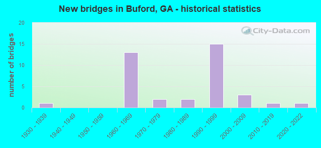
- New bridges - historical statistics
- 11930-1939
- 131960-1969
- 21970-1979
- 21980-1989
- 151990-1999
- 32000-2009
- 12010-2019
- 12020-2022

- Reconstructed bridges - Historical Statistics
- 11940-1949
- 01950-1959
- 01960-1969
- 01970-1979
- 01980-1989
- 11990-1999


- Bridge Condition - Deck
- 4.8%Very good
- 90.5%Good
- 4.8%Fair

- Bridge Condition - Superstructure
- 61.9%Very good
- 38.1%Good

- Bridge Condition - Substructure
- 38.1%Very good
- 61.9%Good

- Bridge Condition - Channel
- 3.6%Excellent
- 39.3%Very good
- 32.1%Good
- 17.9%Satisfactory
- 7.1%Fair

- Bridge Condition - Culverts
- 5.9%Very good
- 88.2%Good
- 5.9%Satisfactory
Find on map >> Show street view
Structure Number: 135002, Location: IN CITY OF WINDER (Lat: 34.015008, Lng: -83.725478), Route carried "on" structure: City street 5416, Year Built: 1969, Status: Open, Structure Length: 1.01m (3.31ft), Average Daily Traffic: 2,640 (year 2012), Truck Traffic: 1%, Average Future Daily Traffic: 3,960 (year 2032), Design Load: H 15, Features Intersected: CEDAR CREEK, Facility Carried by Structure: MILES PATRICK RD
Minimum Vertical Clearance: 30+ m (98+ ft), Kilometerpoint: 1.609, Lanes on structure: 2, Base Highway Network: Yes, Owner: County Highway Agency, Approaching Roadway Width: 6.4m (21.0ft), Skew: 1 degrees, Material/Design: Concrete, Design/Construction: Culvert, Number Of Spans In Main Unit: 3, Length of Maximum Span: 3.0m (9.8ft)
Condition: Channel: Satisfactory, Culverts: Good, Operating Rating: 89.8 metric tons, Method Used To Determine Operating Rating: Load Factor (LF), Inventory Rating: 53.5 metric tons, Method Used To Determine Inventory Rating: Load Factor (LF), Structural Evaluation: Better than present minimum criteria, Waterway Adequacy: Superior to present desirable criteria, Approach Roadway Alignment: Equal to present desirable criteria, Designated Inspection Frequency: Every 24 months, Inspection Date: March 2021, Bridge Improvement Cost: $129,000, Roadway Improvement Cost: $13,000, Total Project Cost: $193,000
Find on map >> Show street view
Structure Number: 135003, Location: IN CITY OF WINDER (Lat: 34.013819, Lng: -83.731269), Route carried "on" structure: City street 5415, Year Built: 1976, Status: Open, Structure Length: 0.88m (2.89ft), Average Daily Traffic: 730 (year 2012), Truck Traffic: 1%, Average Future Daily Traffic: 1,095 (year 2032), Design Load: H 15, Features Intersected: CEDAR CREEK, Facility Carried by Structure: 5TH AVENUE
Minimum Vertical Clearance: 30+ m (98+ ft), Kilometerpoint: 1.609, Lanes on structure: 2, Base Highway Network: Yes, Owner: County Highway Agency, Approaching Roadway Width: 7.9m (25.9ft), Material/Design: Concrete, Design/Construction: Culvert, Number Of Spans In Main Unit: 3, Length of Maximum Span: 2.7m (8.9ft)
Condition: Channel: Satisfactory, Culverts: Good, Operating Rating: 82.5 metric tons, Method Used To Determine Operating Rating: Load Factor (LF), Inventory Rating: 48.9 metric tons, Method Used To Determine Inventory Rating: Load Factor (LF), Structural Evaluation: Better than present minimum criteria, Waterway Adequacy: Equal to present desirable criteria, Approach Roadway Alignment: Equal to present minimum criteria, Designated Inspection Frequency: Every 24 months, Inspection Date: March 2021, Bridge Improvement Cost: $113,000, Roadway Improvement Cost: $11,000, Total Project Cost: $170,000
Find on map >> Show street view
Structure Number: 1350017, Location: IN SOUTH BUFORD (Lat: 34.090581, Lng: -83.998894), Route carried "on" structure: US 23, Year Built: 1965, Status: Open, Structure Length: 1.22m (4.00ft), Average Daily Traffic: 46,860 (year 2012), Truck Traffic: 4%, Average Future Daily Traffic: 70,290 (year 2032), Design Load: H 15, Features Intersected: SUWANEE CREEK
Minimum Vertical Clearance: 30+ m (98+ ft), Kilometerpoint: 9.656, Lanes on structure: 4, Base Highway Network: Yes, Owner: State Highway Agency, Approaching Roadway Width: 14.6m (47.9ft), Skew: 11 degrees, Material/Design: Concrete, Design/Construction: Culvert, Number Of Spans In Main Unit: 4, Length of Maximum Span: 2.7m (8.9ft)
Condition: Channel: Good, Culverts: Good, Structural Evaluation: Better than present minimum criteria, Waterway Adequacy: Equal to present desirable criteria, Approach Roadway Alignment: Equal to present desirable criteria, Designated Inspection Frequency: Every 24 months, Inspection Date: December 2021, Bridge Improvement Cost: $242,000, Roadway Improvement Cost: $24,000, Total Project Cost: $362,000
Find on map >> Show street view
Structure Number: 1350021, Location: 3.1 MI S OF BUFORD (Lat: 34.066856, Lng: -84.010256), Route carried "on" structure: County highway 96, Year Built: 1966, Status: Open, Structure Length: 8.78m (28.81ft), Average Daily Traffic: 2,290 (year 2012), Truck Traffic: 2%, Average Future Daily Traffic: 3,435 (year 2032), Design Load: HS 20, Features Intersected: SR 419 (I-985 US 23), Facility Carried by Structure: WOODWARD MILL ROAD
Minimum Vertical Clearance: 30+ m (98+ ft), Kilometerpoint: 3.219, Lanes on structure: 2, Lanes under structure: 4, Base Highway Network: Yes, Owner: State Highway Agency, Approaching Roadway Width: 6.7m (22.0ft), Skew: 2 degrees, Material/Design: Steel continuous, Design/Construction: Stringer/Multi-beam, Number Of Spans In Main Unit: 4, Length of Maximum Span: 25.9m (85.0ft), Curb or Sidewalk Widths: Left: 0.6m (2.0ft), Right: 0.6m (2.0ft), Curb-To-Curb Width: 7.3m (24.0ft), Out-to-Out Width: 9.1m (29.9ft)
Condition: Deck: Fair, Superstructure: Very good, Substructure: Good, Operating Rating: 33.5 metric tons, Method Used To Determine Operating Rating: Load Factor (LF), Inventory Rating: 19.9 metric tons, Method Used To Determine Inventory Rating: Load Factor (LF), Structural Evaluation: Somewhat better than minimum adequacy, Deck Geometry: High priority of replacement, Underclear: Somewhat better than minimum adequacy, Approach Roadway Alignment: Equal to present minimum criteria, Length Of Structure Improvement: 48.98m (160.70ft), Designated Inspection Frequency: Every 24 months, Inspection Date: October 2021, Bridge Improvement Cost: $1,125,000, Roadway Improvement Cost: $113,000, Total Project Cost: $1,688,000, Deck Structure Type: Concrete Cast-file-Place
Find on map >> Show street view
Structure Number: 1350029, Location: 1.3 MI E OF BUFORD (Lat: 34.119853, Lng: -83.970858), Route carried "on" structure: City street 5500, Year Built: 1968, Status: Open, Structure Length: 7.13m (23.39ft), Average Daily Traffic: 7,130 (year 2012), Truck Traffic: 1%, Average Future Daily Traffic: 10,695 (year 2032), Design Load: HS 20+Mod, Features Intersected: SR 419 (I-985 US 23), Facility Carried by Structure: THOMPSON MILL ROAD
Minimum Vertical Clearance: 30+ m (98+ ft), Kilometerpoint: 4.828, Lanes on structure: 2, Lanes under structure: 4, Base Highway Network: Yes, Owner: State Highway Agency, Approaching Roadway Width: 11.0m (36.1ft), Skew: 2 degrees, Material/Design: Steel, Design/Construction: Stringer/Multi-beam, Number Of Spans In Main Unit: 4, Length of Maximum Span: 22.6m (74.1ft), Curb or Sidewalk Widths: Left: 0.2m (0.7ft), Right: 0.2m (0.7ft), Curb-To-Curb Width: 9.4m (30.8ft), Out-to-Out Width: 10.6m (34.8ft)
Condition: Deck: Good, Superstructure: Very good, Substructure: Good, Operating Rating: 76.2 metric tons, Method Used To Determine Operating Rating: Load Factor (LF), Inventory Rating: 45.3 metric tons, Method Used To Determine Inventory Rating: Load Factor (LF), Structural Evaluation: Better than present minimum criteria, Deck Geometry: Meets minimum limits, Underclear: Meets minimum limits, Approach Roadway Alignment: Better than present minimum criteria, Designated Inspection Frequency: Every 24 months, Inspection Date: October 2021, Bridge Improvement Cost: $914,000, Roadway Improvement Cost: $91,000, Total Project Cost: $1,371,000, Deck Structure Type: Concrete Cast-file-Place
Find on map >> Show street view
Structure Number: 1350032, Location: EAST SIDE OF BUFORD (Lat: 34.106956, Lng: -83.981342), Route carried "on" structure: City street 5504, Year Built: 1968, Year Reconstructed: 1996, Status: Open, Structure Length: 6.49m (21.29ft), Average Daily Traffic: 14,640 (year 2012), Truck Traffic: 1%, Average Future Daily Traffic: 21,960 (year 2032), Design Load: HS 20, Features Intersected: SR 419 (I-985 US 23), Facility Carried by Structure: HAMILTON MILL ROAD
Minimum Vertical Clearance: 30+ m (98+ ft), Kilometerpoint: 0.000, Lanes on structure: 4, Lanes under structure: 4, Base Highway Network: Yes, Owner: State Highway Agency, Approaching Roadway Width: 20.1m (65.9ft), Skew: 11 degrees, Material/Design: Steel continuous, Design/Construction: Stringer/Multi-beam, Number Of Spans In Main Unit: 4, Length of Maximum Span: 22.3m (73.2ft), Curb or Sidewalk Widths: Left: 1.8m (5.9ft), Right: 1.8m (5.9ft), Curb-To-Curb Width: 19.5m (64.0ft), Out-to-Out Width: 28.7m (94.2ft)
Condition: Deck: Good, Superstructure: Good, Substructure: Good, Operating Rating: 35.3 metric tons, Method Used To Determine Operating Rating: Load Factor (LF), Inventory Rating: 20.8 metric tons, Method Used To Determine Inventory Rating: Load Factor (LF), Structural Evaluation: Somewhat better than minimum adequacy, Deck Geometry: Better than present minimum criteria, Underclear: Meets minimum limits, Approach Roadway Alignment: Better than present minimum criteria, Designated Inspection Frequency: Every 24 months, Inspection Date: October 2021, Bridge Improvement Cost: $1,286,000, Roadway Improvement Cost: $129,000, Total Project Cost: $1,929,000, Deck Structure Type: Concrete Cast-file-Place
Find on map >> Show street view
Structure Number: 1350044, Location: 3.4 MI SE OF BUFORD (Lat: 34.070194, Lng: -83.973161), Route carried "on" structure: State highway 324, Year Built: 1972, Status: Open, Structure Length: 0.88m (2.89ft), Average Daily Traffic: 17,010 (year 2012), Truck Traffic: 1%, Average Future Daily Traffic: 25,515 (year 2032), Design Load: H 15, Features Intersected: IVY CREEK, Facility Carried by Structure: MT GRAVEL SPNGS RD
Minimum Vertical Clearance: 30+ m (98+ ft), Kilometerpoint: 1.609, Lanes on structure: 2, Base Highway Network: Yes, Owner: State Highway Agency, Approaching Roadway Width: 6.4m (21.0ft), Material/Design: Concrete, Design/Construction: Culvert, Number Of Spans In Main Unit: 3, Length of Maximum Span: 2.7m (8.9ft), Curb or Sidewalk Widths: Left: 0.0m, Right: 1.2m (3.9ft)
Condition: Channel: Good, Culverts: Good, Structural Evaluation: Better than present minimum criteria, Waterway Adequacy: Superior to present desirable criteria, Approach Roadway Alignment: Equal to present minimum criteria, Designated Inspection Frequency: Every 24 months, Inspection Date: September 2021, Bridge Improvement Cost: $113,000, Roadway Improvement Cost: $11,000, Total Project Cost: $170,000
Find on map >> Show street view
Structure Number: 1350057, Location: 4 MI SE OF BUFORD (Lat: 34.056678, Lng: -83.976100), Route carried "on" structure: Interstate 85, Year Built: 1962, Status: Open, Structure Length: 0.88m (2.89ft), Average Daily Traffic: 76,290 (year 2012), Truck Traffic: 1%, Average Future Daily Traffic: 114,435 (year 2032), Design Load: HS 20+Mod, Features Intersected: LITTLE IVY CREEK
Minimum Vertical Clearance: 30+ m (98+ ft), Kilometerpoint: 186.684, Lanes on structure: 8, Base Highway Network: Yes, Owner: State Highway Agency, Approaching Roadway Width: 23.2m (76.1ft), Skew: 12 degrees, Material/Design: Concrete, Design/Construction: Culvert, Number Of Spans In Main Unit: 3, Length of Maximum Span: 2.7m (8.9ft)
Condition: Channel: Very good, Culverts: Good, Operating Rating: 55.3 metric tons, Method Used To Determine Operating Rating: Field evaluation and documented engineering judgment, Inventory Rating: 32.6 metric tons, Method Used To Determine Inventory Rating: Field evaluation and documented engineering judgment, Structural Evaluation: Better than present minimum criteria, Waterway Adequacy: Equal to present desirable criteria, Approach Roadway Alignment: Better than present minimum criteria, Designated Inspection Frequency: Every 24 months, Inspection Date: November 2021, Bridge Improvement Cost: $175,000, Roadway Improvement Cost: $18,000, Total Project Cost: $263,000
Find on map >> Show street view
Structure Number: 1350058, Location: 4.3 MI SE OF BUFORD (Lat: 34.066267, Lng: -83.938867), Route carried "on" structure: Interstate 85, Year Built: 1962, Status: Open, Structure Length: 0.70m (2.30ft), Average Daily Traffic: 76,290 (year 2012), Truck Traffic: 1%, Average Future Daily Traffic: 114,435 (year 2032), Design Load: HS 20+Mod, Features Intersected: LITTLE IVY CREEK
Minimum Vertical Clearance: 30+ m (98+ ft), Kilometerpoint: 189.903, Lanes on structure: 8, Base Highway Network: Yes, Owner: State Highway Agency, Approaching Roadway Width: 23.2m (76.1ft), Skew: 10 degrees, Material/Design: Concrete, Design/Construction: Culvert, Number Of Spans In Main Unit: 3, Length of Maximum Span: 2.1m (6.9ft)
Condition: Channel: Fair, Culverts: Good, Structural Evaluation: Better than present minimum criteria, Waterway Adequacy: Equal to present desirable criteria, Approach Roadway Alignment: Better than present minimum criteria, Designated Inspection Frequency: Every 24 months, Inspection Date: November 2021, Bridge Improvement Cost: $139,000, Roadway Improvement Cost: $14,000, Total Project Cost: $208,000
Find on map >> Show street view
Structure Number: 1350101, Location: 3.4 MI SE OF DULUTH (Lat: 33.977756, Lng: -84.095125), Route carried "on" structure: State highway 120, Year Built: 1960, Status: Open, Structure Length: 0.67m (2.20ft), Average Daily Traffic: 22,020 (year 2012), Truck Traffic: 1%, Average Future Daily Traffic: 33,030 (year 2032), Design Load: HS 20+Mod, Features Intersected: FORK CREEK
Minimum Vertical Clearance: 30+ m (98+ ft), Kilometerpoint: 9.656, Lanes on structure: 5, Base Highway Network: Yes, Owner: State Highway Agency, Approaching Roadway Width: 25.3m (83.0ft), Skew: 9 degrees, Material/Design: Concrete, Design/Construction: Culvert, Number Of Spans In Main Unit: 2, Length of Maximum Span: 3.4m (11.2ft)
Condition: Channel: Good, Culverts: Good, Operating Rating: 55.3 metric tons, Method Used To Determine Operating Rating: Field evaluation and documented engineering judgment, Inventory Rating: 32.6 metric tons, Method Used To Determine Inventory Rating: Field evaluation and documented engineering judgment, Structural Evaluation: Better than present minimum criteria, Waterway Adequacy: Equal to present desirable criteria, Approach Roadway Alignment: Equal to present desirable criteria, Designated Inspection Frequency: Every 24 months, Inspection Date: December 2021, Bridge Improvement Cost: $156,000, Roadway Improvement Cost: $16,000, Total Project Cost: $234,000
Find on map >> Show street view
Structure Number: 1350108, Location: IN SOUTH BUFORD (Lat: 34.092347, Lng: -84.004753), Route carried "on" structure: US 23, Year Built: 1965, Status: Open, Structure Length: 0.85m (2.79ft), Average Daily Traffic: 41,790 (year 2012), Truck Traffic: 1%, Average Future Daily Traffic: 62,685 (year 2032), Design Load: H 15, Features Intersected: SUWANEE CREEK TRIB
Minimum Vertical Clearance: 30+ m (98+ ft), Kilometerpoint: 9.656, Lanes on structure: 4, Base Highway Network: Yes, Owner: State Highway Agency, Approaching Roadway Width: 22.9m (75.1ft), Skew: 14 degrees, Material/Design: Concrete, Design/Construction: Culvert, Number Of Spans In Main Unit: 3, Length of Maximum Span: 2.4m (7.9ft)
Condition: Channel: Good, Culverts: Good, Structural Evaluation: Better than present minimum criteria, Waterway Adequacy: Equal to present desirable criteria, Approach Roadway Alignment: Equal to present desirable criteria, Designated Inspection Frequency: Every 24 months, Inspection Date: December 2021, Bridge Improvement Cost: $169,000, Roadway Improvement Cost: $17,000, Total Project Cost: $254,000
Find on map >> Show street view
Structure Number: 135502, Location: 2.8 MI E OF BUFORD (Lat: 34.110847, Lng: -83.950228), Route carried "on" structure: County highway 120, Year Built: 1965, Status: Open, Structure Length: 0.73m (2.40ft), Average Daily Traffic: 5,400 (year 2012), Truck Traffic: 1%, Average Future Daily Traffic: 8,100 (year 2032), Design Load: H 15, Features Intersected: IVY CREEK, Facility Carried by Structure: THOMPSON MILL ROAD
Minimum Vertical Clearance: 30+ m (98+ ft), Kilometerpoint: 8.047, Lanes on structure: 2, Base Highway Network: Yes, Owner: County Highway Agency, Approaching Roadway Width: 7.3m (24.0ft), Skew: 3 degrees, Material/Design: Concrete, Design/Construction: Culvert, Number Of Spans In Main Unit: 2, Length of Maximum Span: 3.7m (12.1ft)
Condition: Channel: Satisfactory, Culverts: Good, Operating Rating: 43.5 metric tons, Method Used To Determine Operating Rating: Field evaluation and documented engineering judgment, Inventory Rating: 24.4 metric tons, Method Used To Determine Inventory Rating: Field evaluation and documented engineering judgment, Structural Evaluation: Equal to present minimum criteria, Waterway Adequacy: Equal to present desirable criteria, Approach Roadway Alignment: Equal to present desirable criteria, Designated Inspection Frequency: Every 24 months, Inspection Date: September 2021, Bridge Improvement Cost: $94,000, Roadway Improvement Cost: $9,000, Total Project Cost: $141,000
Find on map >> Show street view
Structure Number: 1355021, Location: IN CITY OF BUFORD (Lat: 34.121858, Lng: -83.983089), Route carried "on" structure: County highway 5500, Year Built: 1964, Status: Open, Structure Length: 0.64m (2.10ft), Average Daily Traffic: 7,130 (year 2012), Truck Traffic: 1%, Average Future Daily Traffic: 10,695 (year 2032), Design Load: H 15, Features Intersected: SUWANEE CREEK, Facility Carried by Structure: THOMPSON MILL ROAD
Minimum Vertical Clearance: 30+ m (98+ ft), Kilometerpoint: 6.437, Lanes on structure: 2, Owner: County Highway Agency, Approaching Roadway Width: 6.7m (22.0ft), Material/Design: Concrete, Design/Construction: Culvert, Number Of Spans In Main Unit: 2, Length of Maximum Span: 3.0m (9.8ft)
Condition: Channel: Satisfactory, Culverts: Good, Operating Rating: 43.5 metric tons, Method Used To Determine Operating Rating: Field evaluation and documented engineering judgment, Inventory Rating: 24.4 metric tons, Method Used To Determine Inventory Rating: Field evaluation and documented engineering judgment, Structural Evaluation: Equal to present minimum criteria, Waterway Adequacy: Somewhat better than minimum adequacy, Approach Roadway Alignment: Equal to present desirable criteria, Designated Inspection Frequency: Every 24 months, Inspection Date: December 2021, Bridge Improvement Cost: $82,000, Roadway Improvement Cost: $8,000, Total Project Cost: $123,000
Find on map >> Show street view
Structure Number: 1355022, Location: BUFORD - SOUTHSIDE (Lat: 34.096661, Lng: -83.995928), Route carried "on" structure: County highway 123, Year Built: 1961, Status: Open, Structure Length: 1.46m (4.79ft), Average Daily Traffic: 110 (year 2012), Truck Traffic: 1%, Average Future Daily Traffic: 165 (year 2032), Design Load: H 15, Features Intersected: SUWANEE CREEK, Facility Carried by Structure: MADDOX ROAD
Minimum Vertical Clearance: 30+ m (98+ ft), Kilometerpoint: 0.000, Lanes on structure: 2, Owner: County Highway Agency, Approaching Roadway Width: 5.5m (18.0ft), Skew: 3 degrees, Material/Design: Concrete, Design/Construction: Culvert, Number Of Spans In Main Unit: 4, Length of Maximum Span: 3.4m (11.2ft)
Condition: Channel: Good, Culverts: Good, Operating Rating: 43.5 metric tons, Method Used To Determine Operating Rating: Field evaluation and documented engineering judgment, Inventory Rating: 24.4 metric tons, Method Used To Determine Inventory Rating: Field evaluation and documented engineering judgment, Structural Evaluation: Equal to present minimum criteria, Waterway Adequacy: Equal to present minimum criteria, Approach Roadway Alignment: Better than present minimum criteria, Designated Inspection Frequency: Every 24 months, Inspection Date: December 2021, Bridge Improvement Cost: $188,000, Roadway Improvement Cost: $19,000, Total Project Cost: $281,000
Find on map >> Show street view
Structure Number: 1355023, Location: 2.2 MI E OF BUFORD (Lat: 34.098428, Lng: -83.963700), Route carried "on" structure: County highway 134, Year Built: 1980, Status: Open, Structure Length: 1.34m (4.40ft), Average Daily Traffic: 740 (year 2012), Truck Traffic: 1%, Average Future Daily Traffic: 1,110 (year 2032), Design Load: HS 20+Mod, Features Intersected: IVY CREEK, Facility Carried by Structure: HAMILTON MILL LANE
Minimum Vertical Clearance: 30+ m (98+ ft), Kilometerpoint: 6.437, Lanes on structure: 2, Base Highway Network: Yes, Owner: County Highway Agency, Approaching Roadway Width: 6.4m (21.0ft), Material/Design: Concrete, Design/Construction: Culvert, Number Of Spans In Main Unit: 4, Length of Maximum Span: 3.0m (9.8ft)
Condition: Channel: Fair, Culverts: Good, Operating Rating: 55.3 metric tons, Method Used To Determine Operating Rating: Field evaluation and documented engineering judgment, Inventory Rating: 32.6 metric tons, Method Used To Determine Inventory Rating: Field evaluation and documented engineering judgment, Structural Evaluation: Better than present minimum criteria, Waterway Adequacy: Equal to present desirable criteria, Approach Roadway Alignment: Equal to present minimum criteria, Designated Inspection Frequency: Every 24 months, Inspection Date: September 2021, Bridge Improvement Cost: $172,000, Roadway Improvement Cost: $17,000, Total Project Cost: $258,000
Find on map >> Show street view
Structure Number: 1355025, Location: 4.4 MI SE OF BUFORD (Lat: 34.054400, Lng: -83.956208), Route carried "on" structure: County highway 155, Year Built: 1992, Year Reconstructed: 2021, Status: Open, Structure Length: 1.22m (4.00ft), Average Daily Traffic: 1,810 (year 2012), Truck Traffic: 1%, Average Future Daily Traffic: 2,715 (year 2032), Design Load: HS 20, Features Intersected: LITTLE IVY CREEK, Facility Carried by Structure: SUNNY HILL ROAD
Minimum Vertical Clearance: 30+ m (98+ ft), Kilometerpoint: 0.000, Lanes on structure: 2, Base Highway Network: Yes, Owner: County Highway Agency, Approaching Roadway Width: 7.3m (24.0ft), Skew: 4 degrees, Material/Design: Concrete, Design/Construction: Culvert, Number Of Spans In Main Unit: 5, Length of Maximum Span: 4.3m (14.1ft)
Condition: Channel: Very good, Culverts: Good, Operating Rating: 55.3 metric tons, Method Used To Determine Operating Rating: Field evaluation and documented engineering judgment, Inventory Rating: 32.6 metric tons, Method Used To Determine Inventory Rating: Field evaluation and documented engineering judgment, Structural Evaluation: Better than present minimum criteria, Waterway Adequacy: Equal to present minimum criteria, Approach Roadway Alignment: Equal to present minimum criteria, Designated Inspection Frequency: Every 24 months, Inspection Date: September 2021, Bridge Improvement Cost: $113,000, Roadway Improvement Cost: $11,000, Total Project Cost: $170,000
Find on map >> Show street view
Structure Number: 1355084, Location: 3 MI SE OF BUFORD (Lat: 34.079389, Lng: -83.971089), Route carried "on" structure: County highway 918, Year Built: 1980, Status: Open, Structure Length: 1.98m (6.50ft), Average Daily Traffic: 1,930 (year 2012), Truck Traffic: 1%, Average Future Daily Traffic: 2,895 (year 2032), Design Load: HS 20+Mod, Features Intersected: IVY CREEK, Facility Carried by Structure: KILGORE ROAD
Minimum Vertical Clearance: 30+ m (98+ ft), Kilometerpoint: 1.609, Lanes on structure: 2, Base Highway Network: Yes, Owner: County Highway Agency, Approaching Roadway Width: 7.3m (24.0ft), Skew: 3 degrees, Material/Design: Concrete, Design/Construction: Culvert, Number Of Spans In Main Unit: 6, Length of Maximum Span: 3.7m (12.1ft)
Condition: Channel: Satisfactory, Culverts: Good, Operating Rating: 55.3 metric tons, Method Used To Determine Operating Rating: Field evaluation and documented engineering judgment, Inventory Rating: 32.6 metric tons, Method Used To Determine Inventory Rating: Field evaluation and documented engineering judgment, Structural Evaluation: Better than present minimum criteria, Waterway Adequacy: Equal to present desirable criteria, Approach Roadway Alignment: Equal to present minimum criteria, Designated Inspection Frequency: Every 24 months, Inspection Date: September 2021, Bridge Improvement Cost: $203,000, Roadway Improvement Cost: $20,000, Total Project Cost: $305,000
Find on map >> Show street view
Structure Number: 1355154, Location: IN BUFORD (Lat: 34.113700, Lng: -83.992528), Route carried "on" structure: County highway 5504, Year Built: 1997, Status: Open, Structure Length: 0.91m (2.99ft), Average Daily Traffic: 14,640 (year 2012), Truck Traffic: 1%, Average Future Daily Traffic: 21,960 (year 2032), Design Load: HS 20, Features Intersected: SUWANEE CREEK, Facility Carried by Structure: HAMILTON MILL RD
Minimum Vertical Clearance: 30+ m (98+ ft), Kilometerpoint: 1.609, Lanes on structure: 4, Owner: County Highway Agency, Approaching Roadway Width: 19.5m (64.0ft), Skew: 19 degrees, Material/Design: Concrete, Design/Construction: Culvert, Number Of Spans In Main Unit: 3, Length of Maximum Span: 2.7m (8.9ft)
Condition: Channel: Good, Culverts: Good, Structural Evaluation: Better than present minimum criteria, Waterway Adequacy: Equal to present desirable criteria, Approach Roadway Alignment: Equal to present desirable criteria, Designated Inspection Frequency: Every 24 months, Inspection Date: December 2021, Bridge Improvement Cost: $181,000, Roadway Improvement Cost: $18,000, Total Project Cost: $272,000
Find on map >> Show street view
Structure Number: 1355166, Location: 2 MI S OF BUFORD (Lat: 34.058069, Lng: -83.992483), Route carried "on" structure: State highway 20, Year Built: 1999, Status: Open, Structure Length: 9.91m (32.51ft), Average Daily Traffic: 43,610 (year 2012), Truck Traffic: 4%, Average Future Daily Traffic: 65,415 (year 2032), Design Load: HS 20+Mod, Features Intersected: IVY CREEK
Minimum Vertical Clearance: 30+ m (98+ ft), Kilometerpoint: 14.484, Lanes on structure: 2, Base Highway Network: Yes, Owner: State Highway Agency, Approaching Roadway Width: 15.5m (50.9ft), Skew: 12 degrees, Material/Design: Prestressed concrete, Design/Construction: Stringer/Multi-beam, Number Of Spans In Main Unit: 4, Length of Maximum Span: 35.1m (115.2ft), Curb-To-Curb Width: 15.5m (50.9ft), Out-to-Out Width: 17.1m (56.1ft)
Condition: Deck: Good, Superstructure: Good, Substructure: Very good, Channel: Very good, Operating Rating: 57.1 metric tons, Method Used To Determine Operating Rating: Allowable Stress (AS), Inventory Rating: 34.4 metric tons, Method Used To Determine Inventory Rating: Allowable Stress (AS), Structural Evaluation: Better than present minimum criteria, Deck Geometry: Superior to present desirable criteria, Waterway Adequacy: Equal to present desirable criteria, Approach Roadway Alignment: Equal to present desirable criteria, Designated Inspection Frequency: Every 24 months, Inspection Date: September 2021, Bridge Improvement Cost: $1,270,000, Roadway Improvement Cost: $127,000, Total Project Cost: $1,905,000, Deck Structure Type: Concrete Cast-file-Place
Find on map >> Show street view
Structure Number: 135517, Location: 2 MI S OF BUFORD (Lat: 34.058731, Lng: -83.989281), Route carried "on" structure: Ramp Interstate 85, Year Built: 1999, Status: Open, Structure Length: 9.69m (31.79ft), Average Daily Traffic: 6,760 (year 2012), Truck Traffic: 1%, Average Future Daily Traffic: 10,140 (year 2032), Design Load: HS 20+Mod, Features Intersected: IVY CREEK
Minimum Vertical Clearance: 30+ m (98+ ft), Kilometerpoint: 185.075, Lanes on structure: 1, Base Highway Network: Yes, Owner: State Highway Agency, Approaching Roadway Width: 10.4m (34.1ft), Material/Design: Steel, Design/Construction: Stringer/Multi-beam, Number Of Spans In Main Unit: 3, Length of Maximum Span: 39.0m (128.0ft), Curb-To-Curb Width: 10.4m (34.1ft), Out-to-Out Width: 10.4m (34.1ft)
Condition: Deck: Good, Superstructure: Very good, Substructure: Very good, Channel: Very good, Operating Rating: 58.9 metric tons, Method Used To Determine Operating Rating: Load Factor (LF), Inventory Rating: 35.3 metric tons, Method Used To Determine Inventory Rating: Load Factor (LF), Structural Evaluation: Equal to present desirable criteria, Deck Geometry: Superior to present desirable criteria, Waterway Adequacy: Equal to present desirable criteria, Approach Roadway Alignment: Better than present minimum criteria, Designated Inspection Frequency: Every 24 months, Inspection Date: August 2021, Bridge Improvement Cost: $904,000, Roadway Improvement Cost: $90,000, Total Project Cost: $1,355,000, Deck Structure Type: Concrete Cast-file-Place
Find on map >> Show street view
Structure Number: 1355171, Location: 2 MI S OF BUFORD (Lat: 34.058803, Lng: -83.989125), Route carried "on" structure: Ramp Interstate 85, Year Built: 1999, Status: Open, Structure Length: 10.52m (34.51ft), Average Daily Traffic: 8,200 (year 2012), Truck Traffic: 1%, Average Future Daily Traffic: 12,300 (year 2032), Design Load: HS 20+Mod, Features Intersected: IVY CREEK
Minimum Vertical Clearance: 30+ m (98+ ft), Kilometerpoint: 185.075, Lanes on structure: 1, Base Highway Network: Yes, Owner: State Highway Agency, Approaching Roadway Width: 10.4m (34.1ft), Skew: 4 degrees, Material/Design: Prestressed concrete, Design/Construction: Stringer/Multi-beam, Number Of Spans In Main Unit: 3, Length of Maximum Span: 36.6m (120.1ft), Curb-To-Curb Width: 10.4m (34.1ft), Out-to-Out Width: 11.4m (37.4ft)
Condition: Deck: Good, Superstructure: Very good, Substructure: Very good, Channel: Very good, Operating Rating: 63.5 metric tons, Method Used To Determine Operating Rating: Load Factor (LF), Inventory Rating: 29.9 metric tons, Method Used To Determine Inventory Rating: Load Factor (LF), Structural Evaluation: Better than present minimum criteria, Deck Geometry: Superior to present desirable criteria, Waterway Adequacy: Equal to present desirable criteria, Approach Roadway Alignment: Better than present minimum criteria, Designated Inspection Frequency: Every 24 months, Inspection Date: August 2021, Bridge Improvement Cost: $980,000, Roadway Improvement Cost: $98,000, Total Project Cost: $1,471,000, Deck Structure Type: Concrete Cast-file-Place
Find on map >> Show street view
Structure Number: 1355174, Location: 4 MI S OF BUFORD (Lat: 34.059267, Lng: -83.994564), Route carried "on" structure: Ramp Interstate 85, Year Built: 1999, Status: Open, Structure Length: 9.30m (30.51ft), Average Daily Traffic: 8,200 (year 2012), Truck Traffic: 1%, Average Future Daily Traffic: 12,300 (year 2032), Design Load: HS 20+Mod, Features Intersected: IVY CREEK
Minimum Vertical Clearance: 30+ m (98+ ft), Kilometerpoint: 185.075, Lanes on structure: 1, Base Highway Network: Yes, Owner: State Highway Agency, Approaching Roadway Width: 10.4m (34.1ft), Skew: 4 degrees, Material/Design: Steel, Design/Construction: Stringer/Multi-beam, Number Of Spans In Main Unit: 3, Length of Maximum Span: 32.0m (105.0ft), Curb-To-Curb Width: 10.4m (34.1ft), Out-to-Out Width: 11.3m (37.1ft)
Condition: Deck: Good, Superstructure: Very good, Substructure: Very good, Channel: Very good, Operating Rating: 58.9 metric tons, Method Used To Determine Operating Rating: Load Factor (LF), Inventory Rating: 35.3 metric tons, Method Used To Determine Inventory Rating: Load Factor (LF), Structural Evaluation: Equal to present desirable criteria, Deck Geometry: Superior to present desirable criteria, Waterway Adequacy: Equal to present desirable criteria, Approach Roadway Alignment: Equal to present desirable criteria, Designated Inspection Frequency: Every 24 months, Inspection Date: August 2021, Bridge Improvement Cost: $867,000, Roadway Improvement Cost: $87,000, Total Project Cost: $1,300,000, Deck Structure Type: Concrete Cast-file-Place
Find on map >> Show street view
Structure Number: 1355175, Location: 3 MI S OF BUFORD (Lat: 34.059156, Lng: -83.994494), Route carried "on" structure: Ramp Interstate 85, Year Built: 1999, Status: Open, Structure Length: 8.47m (27.79ft), Average Daily Traffic: 8,200 (year 2012), Truck Traffic: 1%, Average Future Daily Traffic: 12,300 (year 2032), Design Load: HS 20+Mod, Features Intersected: IVY CREEK
Minimum Vertical Clearance: 30+ m (98+ ft), Kilometerpoint: 185.075, Lanes on structure: 1, Base Highway Network: Yes, Owner: State Highway Agency, Approaching Roadway Width: 10.4m (34.1ft), Material/Design: Steel, Design/Construction: Stringer/Multi-beam, Number Of Spans In Main Unit: 3, Length of Maximum Span: 34.1m (111.9ft), Curb-To-Curb Width: 10.4m (34.1ft), Out-to-Out Width: 11.4m (37.4ft)
Condition: Deck: Good, Superstructure: Very good, Substructure: Good, Channel: Very good, Operating Rating: 53.5 metric tons, Method Used To Determine Operating Rating: Load Factor (LF), Inventory Rating: 31.7 metric tons, Method Used To Determine Inventory Rating: Load Factor (LF), Structural Evaluation: Better than present minimum criteria, Deck Geometry: Superior to present desirable criteria, Waterway Adequacy: Equal to present desirable criteria, Approach Roadway Alignment: Meets minimum limits, Designated Inspection Frequency: Every 24 months, Inspection Date: August 2021, Bridge Improvement Cost: $790,000, Roadway Improvement Cost: $79,000, Total Project Cost: $1,185,000, Deck Structure Type: Concrete Cast-file-Place
Find on map >> Show street view
Structure Number: 1355176, Location: 2 MI S OF BUFORD (Lat: 34.057944, Lng: -83.992844), Route carried "on" structure: State highway 20, Year Built: 1999, Status: Open, Structure Length: 5.64m (18.50ft), Average Daily Traffic: 43,610 (year 2012), Truck Traffic: 4%, Average Future Daily Traffic: 65,415 (year 2032), Design Load: HS 20+Mod, Features Intersected: IVY CREEK
Minimum Vertical Clearance: 30+ m (98+ ft), Kilometerpoint: 14.484, Lanes on structure: 3, Base Highway Network: Yes, Owner: State Highway Agency, Approaching Roadway Width: 15.2m (49.9ft), Skew: 12 degrees, Material/Design: Prestressed concrete, Design/Construction: Stringer/Multi-beam, Number Of Spans In Main Unit: 2, Length of Maximum Span: 35.1m (115.2ft), Curb-To-Curb Width: 16.4m (53.8ft), Out-to-Out Width: 16.4m (53.8ft)
Condition: Deck: Good, Superstructure: Good, Substructure: Very good, Channel: Very good, Operating Rating: 84.3 metric tons, Method Used To Determine Operating Rating: Allowable Stress (AS), Inventory Rating: 49.8 metric tons, Method Used To Determine Inventory Rating: Allowable Stress (AS), Structural Evaluation: Better than present minimum criteria, Deck Geometry: Better than present minimum criteria, Waterway Adequacy: Equal to present desirable criteria, Approach Roadway Alignment: Equal to present desirable criteria, Designated Inspection Frequency: Every 24 months, Inspection Date: September 2021, Bridge Improvement Cost: $920,000, Roadway Improvement Cost: $92,000, Total Project Cost: $1,380,000, Deck Structure Type: Concrete Cast-file-Place
Find on map >> Show street view
Structure Number: 1355178, Location: 2.25 MI SE OF BUFORD (Lat: 34.087000, Lng: -83.993589), Route carried "on" structure: US 23, Year Built: 1999, Status: Open, Structure Length: 8.44m (27.69ft), Average Daily Traffic: 78,020 (year 2012), Truck Traffic: 1%, Average Future Daily Traffic: 117,030 (year 2032), Design Load: HS 20+Mod, Features Intersected: SR 419 (I-985)
Minimum Vertical Clearance: 30+ m (98+ ft), Kilometerpoint: 11.265, Lanes on structure: 10, Lanes under structure: 4, Base Highway Network: Yes, Owner: State Highway Agency, Approaching Roadway Width: 18.3m (60.0ft), Skew: 1 degrees, Material/Design: Steel continuous, Design/Construction: Stringer/Multi-beam, Number Of Spans In Main Unit: 4, Length of Maximum Span: 27.7m (90.9ft), Curb-To-Curb Width: 42.2m (138.5ft), Out-to-Out Width: 43.2m (141.7ft)
Condition: Deck: Good, Superstructure: Good, Substructure: Good, Operating Rating: 51.7 metric tons, Method Used To Determine Operating Rating: Allowable Stress (AS), Inventory Rating: 30.8 metric tons, Method Used To Determine Inventory Rating: Allowable Stress (AS), Structural Evaluation: Better than present minimum criteria, Deck Geometry: Better than present minimum criteria, Underclear: Equal to present desirable criteria, Approach Roadway Alignment: Equal to present desirable criteria, Designated Inspection Frequency: Every 24 months, Inspection Date: October 2021, Bridge Improvement Cost: $3,444,000, Roadway Improvement Cost: $344,000, Total Project Cost: $5,165,000, Deck Structure Type: Concrete Cast-file-Place
Find on map >> Show street view
Structure Number: 1355179, Location: 5.5 MI S OF BUFORD (Lat: 34.056858, Lng: -83.993278), Route carried "on" structure: Interstate 85, Year Built: 1999, Status: Open, Structure Length: 9.27m (30.41ft), Average Daily Traffic: 92,310 (year 2012), Truck Traffic: 14%, Average Future Daily Traffic: 138,465 (year 2032), Design Load: HS 20+Mod, Features Intersected: SR20 - LAWRENCEVILLE HWY
Minimum Vertical Clearance: 30+ m (98+ ft), Kilometerpoint: 185.075, Lanes on structure: 4, Lanes under structure: 6, Base Highway Network: Yes, Owner: State Highway Agency, Approaching Roadway Width: 11.3m (37.1ft), Skew: 32 degrees, Material/Design: Prestressed concrete, Design/Construction: Stringer/Multi-beam, Number Of Spans In Main Unit: 4, Length of Maximum Span: 29.3m (96.1ft), Curb-To-Curb Width: 32.4m (106.3ft), Out-to-Out Width: 34.0m (111.5ft)
Condition: Deck: Good, Superstructure: Very good, Substructure: Good, Operating Rating: 63.5 metric tons, Method Used To Determine Operating Rating: Load Factor (LF), Inventory Rating: 36.2 metric tons, Method Used To Determine Inventory Rating: Load Factor (LF), Structural Evaluation: Better than present minimum criteria, Deck Geometry: Superior to present desirable criteria, Underclear: Better than present minimum criteria, Approach Roadway Alignment: Better than present minimum criteria, Designated Inspection Frequency: Every 24 months, Inspection Date: September 2021, Bridge Improvement Cost: $1,836,000, Roadway Improvement Cost: $184,000, Total Project Cost: $2,754,000, Deck Structure Type: Concrete Cast-file-Place
Find on map >> Show street view
Structure Number: 135518, Location: 5.5 MI S OF BUFORD (Lat: 34.057200, Lng: -83.993056), Route carried "on" structure: Interstate 85, Year Built: 1999, Status: Open, Structure Length: 9.27m (30.41ft), Average Daily Traffic: 92,310 (year 2012), Truck Traffic: 14%, Average Future Daily Traffic: 138,465 (year 2032), Design Load: HS 20+Mod, Features Intersected: SR20 - LAWRENCEVILLE HWY
Minimum Vertical Clearance: 30+ m (98+ ft), Kilometerpoint: 185.075, Lanes on structure: 4, Lanes under structure: 6, Base Highway Network: Yes, Owner: State Highway Agency, Approaching Roadway Width: 11.3m (37.1ft), Skew: 32 degrees, Material/Design: Prestressed concrete, Design/Construction: Stringer/Multi-beam, Number Of Spans In Main Unit: 4, Length of Maximum Span: 29.3m (96.1ft), Curb-To-Curb Width: 32.4m (106.3ft), Out-to-Out Width: 34.0m (111.5ft)
Condition: Deck: Good, Superstructure: Good, Substructure: Good, Operating Rating: 63.5 metric tons, Method Used To Determine Operating Rating: Load Factor (LF), Inventory Rating: 36.2 metric tons, Method Used To Determine Inventory Rating: Load Factor (LF), Structural Evaluation: Better than present minimum criteria, Deck Geometry: Superior to present desirable criteria, Underclear: Better than present minimum criteria, Approach Roadway Alignment: Better than present minimum criteria, Designated Inspection Frequency: Every 24 months, Inspection Date: September 2021, Bridge Improvement Cost: $1,836,000, Roadway Improvement Cost: $184,000, Total Project Cost: $2,754,000, Deck Structure Type: Concrete Cast-file-Place
Find on map >> Show street view
Structure Number: 1355188, Location: WEST SIDE OF BUFORD (Lat: 34.124414, Lng: -84.021467), Route carried "on" structure: County highway 5507, Year Built: 1999, Status: Open, Structure Length: 0.79m (2.59ft), Average Daily Traffic: 3,300 (year 2012), Truck Traffic: 1%, Average Future Daily Traffic: 4,950 (year 2032), Design Load: HS 20+Mod, Features Intersected: RICHLAND CREEK., Facility Carried by Structure: LITTLE MILL ROAD
Minimum Vertical Clearance: 30+ m (98+ ft), Kilometerpoint: 1.609, Lanes on structure: 4, Base Highway Network: Yes, Owner: County Highway Agency, Approaching Roadway Width: 7.3m (24.0ft), Material/Design: Concrete, Design/Construction: Culvert, Number Of Spans In Main Unit: 3, Length of Maximum Span: 2.4m (7.9ft)
Condition: Channel: Good, Culverts: Very good, Structural Evaluation: Equal to present desirable criteria, Waterway Adequacy: Equal to present desirable criteria, Approach Roadway Alignment: Equal to present desirable criteria, Designated Inspection Frequency: Every 24 months, Inspection Date: November 2021, Bridge Improvement Cost: $157,000, Roadway Improvement Cost: $16,000, Total Project Cost: $235,000
Find on map >> Show street view
Structure Number: 1355192, Location: 4.8 MI SE OF BUFORD (Lat: 34.075067, Lng: -83.917792), Route carried "on" structure: County highway 134, Year Built: 2001, Status: Open, Structure Length: 6.74m (22.11ft), Average Daily Traffic: 34,210 (year 2012), Truck Traffic: 1%, Average Future Daily Traffic: 51,315 (year 2032), Design Load: HS 20+Mod, Features Intersected: I-85 (SR 403), Facility Carried by Structure: HAMILTON MILL RD
Minimum Vertical Clearance: 30+ m (98+ ft), Kilometerpoint: 0.000, Lanes on structure: 5, Lanes under structure: 6, Base Highway Network: Yes, Owner: State Highway Agency, Approaching Roadway Width: 8.5m (27.9ft), Skew: 1 degrees, Material/Design: Prestressed concrete, Design/Construction: Stringer/Multi-beam, Number Of Spans In Main Unit: 2, Length of Maximum Span: 33.8m (110.9ft), Curb or Sidewalk Widths: Left: 1.8m (5.9ft), Right: 1.8m (5.9ft), Curb-To-Curb Width: 21.9m (71.9ft), Out-to-Out Width: 26.2m (86.0ft)
Condition: Deck: Good, Superstructure: Good, Substructure: Very good, Operating Rating: 51.7 metric tons, Method Used To Determine Operating Rating: Allowable Stress (AS), Inventory Rating: 30.8 metric tons, Method Used To Determine Inventory Rating: Allowable Stress (AS), Structural Evaluation: Better than present minimum criteria, Deck Geometry: Somewhat better than minimum adequacy, Underclear: Equal to present minimum criteria, Approach Roadway Alignment: Somewhat better than minimum adequacy, Designated Inspection Frequency: Every 24 months, Inspection Date: November 2021, Bridge Improvement Cost: $1,570,000, Roadway Improvement Cost: $157,000, Total Project Cost: $2,355,000, Deck Structure Type: Concrete Cast-file-Place
Find on map >> Show street view
Structure Number: 135522, Location: 3.3 MI SE DULUTH (Lat: 33.964522, Lng: -84.098725), Route carried "on" structure: Ramp State highway 316, Year Built: 2008, Status: Open, Structure Length: 2.56m (8.40ft), Average Daily Traffic: 8,000 (year 2005), Truck Traffic: 10%, Average Future Daily Traffic: 16,000 (year 2031), Design Load: HS 20+Mod, Features Intersected: I-85 NBCD
Minimum Vertical Clearance: 30+ m (98+ ft), Kilometerpoint: 0.000, Lanes on structure: 2, Lanes under structure: 3, Base Highway Network: Yes, Owner: State Highway Agency, Approaching Roadway Width: 18.3m (60.0ft), Skew: 32 degrees, Material/Design: Prestressed concrete, Design/Construction: Stringer/Multi-beam, Number Of Spans In Main Unit: 1, Length of Maximum Span: 25.6m (84.0ft), Curb-To-Curb Width: 18.2m (59.7ft), Out-to-Out Width: 20.0m (65.6ft)
Condition: Deck: Very good, Superstructure: Very good, Substructure: Good, Operating Rating: 89.8 metric tons, Method Used To Determine Operating Rating: Allowable Stress (AS), Inventory Rating: 58.0 metric tons, Method Used To Determine Inventory Rating: Allowable Stress (AS), Structural Evaluation: Better than present minimum criteria, Deck Geometry: Superior to present desirable criteria, Underclear: Superior to present desirable criteria, Approach Roadway Alignment: Equal to present minimum criteria, Designated Inspection Frequency: Every 24 months, Inspection Date: September 2021, Bridge Improvement Cost: $328,000, Roadway Improvement Cost: $33,000, Total Project Cost: $492,000, Deck Structure Type: Concrete Cast-file-Place
Find on map >> Show street view
Structure Number: 1355222, Location: BUFORD- WEST SECTION (Lat: 34.133931, Lng: -84.048372), Route carried "on" structure: County highway 5509, Year Built: 2008, Status: Open, Structure Length: 2.68m (8.79ft), Average Daily Traffic: 3,780 (year 2012), Truck Traffic: 1%, Average Future Daily Traffic: 5,670 (year 2032), Design Load: HS 20+Mod, Features Intersected: RICHLAND CREEK, Facility Carried by Structure: SYCAMORE ROAD
Minimum Vertical Clearance: 30+ m (98+ ft), Kilometerpoint: 1.609, Lanes on structure: 2, Base Highway Network: Yes, Owner: County Highway Agency, Approaching Roadway Width: 8.5m (27.9ft), Skew: 1 degrees, Material/Design: Prestressed concrete, Design/Construction: Stringer/Multi-beam, Number Of Spans In Main Unit: 1, Length of Maximum Span: 26.8m (87.9ft), Curb-To-Curb Width: 13.5m (44.3ft), Out-to-Out Width: 14.4m (47.2ft)
Condition: Deck: Good, Superstructure: Very good, Substructure: Good, Channel: Very good, Operating Rating: 46.2 metric tons, Method Used To Determine Operating Rating: Allowable Stress (AS), Inventory Rating: 32.6 metric tons, Method Used To Determine Inventory Rating: Allowable Stress (AS), Structural Evaluation: Better than present minimum criteria, Deck Geometry: Superior to present desirable criteria, Waterway Adequacy: Better than present minimum criteria, Approach Roadway Alignment: Better than present minimum criteria, Designated Inspection Frequency: Every 24 months, Inspection Date: November 2021, Bridge Improvement Cost: $344,000, Roadway Improvement Cost: $34,000, Total Project Cost: $516,000, Deck Structure Type: Concrete Cast-file-Place
Find on map >> Show street view
Structure Number: 1355244, Location: 4.5 MILES SE OF BUFORD (Lat: 34.063322, Lng: -83.947025), Route carried "on" structure: State highway 324, Year Built: 2012, Status: Open, Structure Length: 14.20m (46.59ft), Average Daily Traffic: 77,950 (year 2010), Truck Traffic: 8%, Average Future Daily Traffic: 116,925 (year 2030), Design Load: HS 20+Mod, Features Intersected: I-85, Facility Carried by Structure: MT GRAVEL SPRINGS
Minimum Vertical Clearance: 30+ m (98+ ft), Kilometerpoint: 3.219, Lanes on structure: 6, Lanes under structure: 8, Base Highway Network: Yes, Owner: State Highway Agency, Approaching Roadway Width: 17.1m (56.1ft), Skew: 22 degrees, Material/Design: Steel continuous, Design/Construction: Stringer/Multi-beam, Number Of Spans In Main Unit: 3, Length of Maximum Span: 52.7m (172.9ft), Curb or Sidewalk Widths: Left: 1.8m (5.9ft), Right: 1.8m (5.9ft), Curb-To-Curb Width: 17.1m (56.1ft), Out-to-Out Width: 31.2m (102.4ft)
Condition: Deck: Good, Superstructure: Good, Substructure: Good, Operating Rating: 63.5 metric tons, Method Used To Determine Operating Rating: Load Factor (LF), Inventory Rating: 38.1 metric tons, Method Used To Determine Inventory Rating: Load Factor (LF), Structural Evaluation: Better than present minimum criteria, Deck Geometry: High priority of replacement, Underclear: Better than present minimum criteria, Approach Roadway Alignment: Equal to present desirable criteria, Length Of Structure Improvement: 48.71m (159.81ft), Designated Inspection Frequency: Every 24 months, Inspection Date: November 2021, Bridge Improvement Cost: $1,078,000, Roadway Improvement Cost: $108,000, Total Project Cost: $1,618,000, Deck Structure Type: Concrete Cast-file-Place
Find on map >> Show street view
Structure Number: 1355249, Location: 2 MI S OF BUFORD (Lat: 34.064181, Lng: -83.978567), Route carried "on" structure: County highway 6446, Year Built: 1999, Status: Open, Structure Length: 10.24m (33.60ft), Average Daily Traffic: 43,610 (year 2012), Truck Traffic: 4%, Average Future Daily Traffic: 65,415 (year 2032), Design Load: HS 20+Mod, Features Intersected: IVY CREEK, Facility Carried by Structure: MALL OF GEORGIA BL
Minimum Vertical Clearance: 30+ m (98+ ft), Kilometerpoint: 14.484, Lanes on structure: 4, Base Highway Network: Yes, Owner: County Highway Agency, Approaching Roadway Width: 17.1m (56.1ft), Skew: 12 degrees, Material/Design: Prestressed concrete, Design/Construction: Stringer/Multi-beam, Number Of Spans In Main Unit: 3, Length of Maximum Span: 35.4m (116.1ft), Curb or Sidewalk Widths: Left: 1.8m (5.9ft), Right: 1.8m (5.9ft), Curb-To-Curb Width: 16.5m (54.1ft), Out-to-Out Width: 26.2m (86.0ft)
Condition: Deck: Good, Superstructure: Very good, Substructure: Very good, Channel: Very good, Operating Rating: 55.3 metric tons, Method Used To Determine Operating Rating: Field evaluation and documented engineering judgment, Inventory Rating: 32.6 metric tons, Method Used To Determine Inventory Rating: Field evaluation and documented engineering judgment, Structural Evaluation: Equal to present desirable criteria, Deck Geometry: Meets minimum limits, Waterway Adequacy: Equal to present desirable criteria, Approach Roadway Alignment: Equal to present desirable criteria, Length Of Structure Improvement: 12.28m (40.29ft), Designated Inspection Frequency: Every 24 months, Inspection Date: September 2021, Bridge Improvement Cost: $29,822,000, Roadway Improvement Cost: $2,982,000, Total Project Cost: $44,733,000 ( Estimate for 2016), Deck Structure Type: Concrete Cast-file-Place
Find on map >> Show street view
Structure Number: 1355252, Location: 2 MI S OF BUFORD (Lat: 34.067717, Lng: -83.977900), Route carried "on" structure: County highway 6447, Year Built: 1999, Status: Open, Structure Length: 8.29m (27.20ft), Average Daily Traffic: 43,610 (year 2012), Truck Traffic: 4%, Average Future Daily Traffic: 65,415 (year 2032), Design Load: HS 20+Mod, Features Intersected: IVY CREEK, Facility Carried by Structure: WOODWARD CROSSING
Minimum Vertical Clearance: 30+ m (98+ ft), Kilometerpoint: 14.484, Lanes on structure: 4, Base Highway Network: Yes, Owner: County Highway Agency, Approaching Roadway Width: 17.1m (56.1ft), Skew: 12 degrees, Material/Design: Prestressed concrete, Design/Construction: Stringer/Multi-beam, Number Of Spans In Main Unit: 3, Length of Maximum Span: 27.7m (90.9ft), Curb or Sidewalk Widths: Left: 1.8m (5.9ft), Right: 1.8m (5.9ft), Curb-To-Curb Width: 16.5m (54.1ft), Out-to-Out Width: 26.2m (86.0ft)
Condition: Deck: Good, Superstructure: Very good, Substructure: Good, Channel: Good, Operating Rating: 54.4 metric tons, Method Used To Determine Operating Rating: Load Factor (LF), Inventory Rating: 32.6 metric tons, Method Used To Determine Inventory Rating: Load Factor (LF), Structural Evaluation: Better than present minimum criteria, Deck Geometry: Meets minimum limits, Waterway Adequacy: Superior to present desirable criteria, Approach Roadway Alignment: Equal to present desirable criteria, Length Of Structure Improvement: 9.94m (32.61ft), Designated Inspection Frequency: Every 24 months, Inspection Date: September 2021, Bridge Improvement Cost: $24,124,000, Roadway Improvement Cost: $2,412,000, Total Project Cost: $36,186,000 ( Estimate for 2017), Deck Structure Type: Concrete Cast-file-Place
Find on map >> Show street view
Structure Number: 1355279, Location: 4.5M SE OF BUFORD (Lat: 34.065178, Lng: -83.946386), Route carried "on" structure: Ramp Interstate 85, Year Built: 2021, Status: Open, Structure Length: 2.71m (8.89ft), Average Daily Traffic: 3,200 (year 2020), Truck Traffic: 17%, Average Future Daily Traffic: 8,500 (year 2040), Design Load: HL 93, Features Intersected: LITTLE IVY CREEK TRIB
Minimum Vertical Clearance: 30+ m (98+ ft), Kilometerpoint: 200.621, Lanes on structure: 1, Base Highway Network: Yes, Owner: State Highway Agency, Approaching Roadway Width: 9.1m (29.9ft), Skew: 2 degrees, Material/Design: Prestressed concrete, Design/Construction: Stringer/Multi-beam, Number Of Spans In Main Unit: 1, Length of Maximum Span: 27.1m (88.9ft), Curb-To-Curb Width: 9.1m (29.9ft), Out-to-Out Width: 10.1m (33.1ft)
Condition: Deck: Good, Superstructure: Very good, Substructure: Very good, Channel: Excellent, Operating Rating: 78.9 metric tons, Method Used To Determine Operating Rating: Load Factor (LF), Inventory Rating: 47.1 metric tons, Method Used To Determine Inventory Rating: Load Factor (LF), Structural Evaluation: Equal to present desirable criteria, Deck Geometry: Superior to present desirable criteria, Waterway Adequacy: Equal to present desirable criteria, Approach Roadway Alignment: Equal to present desirable criteria, Length Of Structure Improvement: 3.26m (10.70ft), Designated Inspection Frequency: Every 24 months, Inspection Date: November 2021, Bridge Improvement Cost: $7,918,000, Roadway Improvement Cost: $792,000, Total Project Cost: $11,877,000 ( Estimate for 2021), Deck Structure Type: Concrete Cast-file-Place
Find on map >> Show street view
Structure Number: 1390008, Location: 2.5 MI SW OF FLOWERY BR (Lat: 34.156358, Lng: -83.953428), Route carried "on" structure: State highway 13, Year Built: 1931, Year Reconstructed: 1954, Status: Open, Structure Length: 0.79m (2.59ft), Average Daily Traffic: 8,520 (year 2012), Truck Traffic: 1%, Average Future Daily Traffic: 12,780 (year 2032), Design Load: H 15, Features Intersected: BIG CREEK, Facility Carried by Structure: ATLANTA HIGHWAY
Minimum Vertical Clearance: 30+ m (98+ ft), Kilometerpoint: 3.219, Lanes on structure: 2, Base Highway Network: Yes, Owner: State Highway Agency, Approaching Roadway Width: 8.5m (27.9ft), Material/Design: Concrete, Design/Construction: Culvert, Number Of Spans In Main Unit: 2, Length of Maximum Span: 4.0m (13.1ft)
Condition: Channel: Good, Culverts: Satisfactory, Inventory Rating: 78.9 metric tons, Method Used To Determine Inventory Rating: Load Factor (LF), Structural Evaluation: Equal to present minimum criteria, Waterway Adequacy: Equal to present desirable criteria, Approach Roadway Alignment: Equal to present desirable criteria, Designated Inspection Frequency: Every 24 months, Inspection Date: April 2021, Bridge Improvement Cost: $102,000, Roadway Improvement Cost: $10,000, Total Project Cost: $152,000
Find on map >> Show street view
Structure Number: 1395079, Location: 5 MI W OF FLOWERY BRANCH (Lat: 34.174219, Lng: -84.015606), Route carried "on" structure: State lands road 1421, Year Built: 1969, Status: Open, Structure Length: 17.01m (55.81ft), Average Daily Traffic: 490 (year 2012), Truck Traffic: 1%, Average Future Daily Traffic: 735 (year 2032), Design Load: HS 20+Mod, Features Intersected: LAKE LANIER, Facility Carried by Structure: LANIER ISLANDS RD
Minimum Vertical Clearance: 30+ m (98+ ft), Kilometerpoint: 0.000, Lanes on structure: 2, Base Highway Network: Yes, Owner: State Agenciy, Approaching Roadway Width: 8.5m (27.9ft), Material/Design: Prestressed concrete, Design/Construction: Stringer/Multi-beam, Number Of Spans In Main Unit: 9, Length of Maximum Span: 18.9m (62.0ft), Curb or Sidewalk Widths: Left: 0.5m (1.6ft), Right: 1.8m (5.9ft), Curb-To-Curb Width: 8.5m (27.9ft), Out-to-Out Width: 11.7m (38.4ft)
Condition: Deck: Good, Superstructure: Good, Substructure: Good, Channel: Very good, Operating Rating: 50.8 metric tons, Method Used To Determine Operating Rating: Allowable Stress (AS), Inventory Rating: 31.7 metric tons, Method Used To Determine Inventory Rating: Allowable Stress (AS), Structural Evaluation: Better than present minimum criteria, Deck Geometry: Somewhat better than minimum adequacy, Waterway Adequacy: Superior to present desirable criteria, Approach Roadway Alignment: Equal to present minimum criteria, Designated Inspection Frequency: Every 24 months, Underwater Inspection Frequency: Every 60 months, Inspection Date: June 2021, Underwater Inspection Date: July 2020, Bridge Improvement Cost: $2,180,000, Roadway Improvement Cost: $218,000, Total Project Cost: $3,270,000, Deck Structure Type: Concrete Cast-file-Place
Find on map >> Show street view
Structure Number: 1395085, Location: 3.4 MI S OF FLOWERY BR (Lat: 34.148247, Lng: -83.970439), Route carried "on" structure: State highway 347, Year Built: 1998, Status: Open, Structure Length: 5.67m (18.60ft), Average Daily Traffic: 12,110 (year 2012), Truck Traffic: 1%, Average Future Daily Traffic: 18,165 (year 2032), Design Load: HS 20+Mod, Features Intersected: NOR SOUTHERN RAILROAD, Facility Carried by Structure: FRIENDSHIP ROAD
Minimum Vertical Clearance: 30+ m (98+ ft), Kilometerpoint: 4.828, Lanes on structure: 4, Base Highway Network: Yes, Owner: State Highway Agency, Approaching Roadway Width: 8.8m (28.9ft), Skew: 11 degrees, Material/Design: Prestressed concrete, Design/Construction: Stringer/Multi-beam, Number Of Spans In Main Unit: 3, Length of Maximum Span: 23.8m (78.1ft), Curb or Sidewalk Widths: Left: 1.8m (5.9ft), Right: 1.8m (5.9ft), Curb-To-Curb Width: 17.7m (58.1ft), Out-to-Out Width: 22.9m (75.1ft)
Condition: Deck: Good, Superstructure: Very good, Substructure: Good, Operating Rating: 55.3 metric tons, Method Used To Determine Operating Rating: Allowable Stress (AS), Inventory Rating: 32.6 metric tons, Method Used To Determine Inventory Rating: Allowable Stress (AS), Structural Evaluation: Better than present minimum criteria, Deck Geometry: Somewhat better than minimum adequacy, Underclear: Superior to present desirable criteria, Approach Roadway Alignment: Better than present minimum criteria, Designated Inspection Frequency: Every 24 months, Inspection Date: May 2021, Bridge Improvement Cost: $727,000, Roadway Improvement Cost: $73,000, Total Project Cost: $1,090,000, Deck Structure Type: Concrete Cast-file-Place, Wearing Surface/Protective System: Wearing Surface: Epoxy Overlay
Find on map >> Show street view
Structure Number: 1350021, Location: 3.1 MI S OF BUFORD (Lat: 34.066856, Lng: -84.010256), Route carried "under" structure: Interstate 985, Structure Length: 0. m, Average Daily Traffic: 48,200 (year 1998), Truck Traffic: 1%, Features Intersected: CR 96 WOODWARD MILL RD, Facility Carried by Structure: WOODWARD MILL ROAD
Minimum Vertical Clearance: 5.99m (19.65ft), Kilometerpoint: 3.219, Lanes on structure: 2, Length of Maximum Span: 0.0m
Find on map >> Show street view
Structure Number: 1350029, Location: 1.3 MI E OF BUFORD (Lat: 34.119853, Lng: -83.970858), Route carried "under" structure: Interstate 985, Structure Length: 0. m, Average Daily Traffic: 35,700 (year 1998), Truck Traffic: 1%, Features Intersected: M-5500 THOMPSON MILL RD., Facility Carried by Structure: THOMPSON MILL ROAD
Minimum Vertical Clearance: 5.86m (19.23ft), Kilometerpoint: 9.656, Lanes on structure: 2, Length of Maximum Span: 0.0m
Find on map >> Show street view
Structure Number: 1350032, Location: EAST SIDE OF BUFORD (Lat: 34.106956, Lng: -83.981342), Route carried "under" structure: Interstate 985, Structure Length: 0. m, Average Daily Traffic: 35,700 (year 1998), Truck Traffic: 1%, Features Intersected: M-5504 HAMILTON MILL RD., Facility Carried by Structure: HAMILTON MILL ROAD
Minimum Vertical Clearance: 5.25m (17.22ft), Kilometerpoint: 8.047, Lanes on structure: 4, Length of Maximum Span: 0.0m
Find on map >> Show street view
Structure Number: 1355178, Location: 2.25 MI SE OF BUFORD (Lat: 34.087000, Lng: -83.993589), Route carried "under" structure: Interstate 985, Structure Length: 0. m, Average Daily Traffic: 35,700 (year 1997), Truck Traffic: 1%, Features Intersected: SR 20 (US 23), Facility Carried by Structure: SR 20 - US 23
Minimum Vertical Clearance: 6.01m (19.72ft), Kilometerpoint: 6.437, Lanes on structure: 10, Length of Maximum Span: 0.0m
Find on map >> Show street view
Structure Number: 1355179, Location: 5.5 MI S OF BUFORD (Lat: 34.056858, Lng: -83.993278), Route carried "under" structure: State highway 20, Structure Length: 0. m, Average Daily Traffic: 13,800 (year 1994), Truck Traffic: 1%, Features Intersected: I-85 NBL, Facility Carried by Structure: I-85 (NBL)
Minimum Vertical Clearance: 7.39m (24.25ft), Kilometerpoint: 14.484, Lanes on structure: 4, Length of Maximum Span: 0.0m
Find on map >> Show street view
Structure Number: 135518, Location: 5.5 MI S OF BUFORD (Lat: 34.057200, Lng: -83.993056), Route carried "under" structure: State highway 20, Structure Length: 0. m, Average Daily Traffic: 17,300 (year 1994), Truck Traffic: 1%, Features Intersected: I-85 SBL., Facility Carried by Structure: I-85 (SBL)
Minimum Vertical Clearance: 6.88m (22.57ft), Kilometerpoint: 14.484, Lanes on structure: 4, Length of Maximum Span: 0.0m
Find on map >> Show street view
Structure Number: 1355192, Location: 4.8 MI SE OF BUFORD (Lat: 34.075067, Lng: -83.917792), Route carried "under" structure: Interstate 85, Structure Length: 0. m, Average Daily Traffic: 7,000 (year 1999), Truck Traffic: 10%, Features Intersected: CR 134 -HAMILTON MILL RD, Facility Carried by Structure: HAMILTON MILL RD
Minimum Vertical Clearance: 5.28m (17.32ft), Kilometerpoint: 193.121, Lanes on structure: 5, Length of Maximum Span: 0.0m
Find on map >> Show street view
Structure Number: 1355244, Location: 4.5 MILES SE OF BUFORD (Lat: 34.063322, Lng: -83.947025), Route carried "under" structure: Interstate 85, Structure Length: 0. m, Average Daily Traffic: 70,100 (year 1998), Truck Traffic: 8%, Features Intersected: I-85 NORTHBOUND, Facility Carried by Structure: MT GRAVEL SPRINGS
Minimum Vertical Clearance: 5.84m (19.16ft), Kilometerpoint: 189.903, Lanes on structure: 6, Length of Maximum Span: 0.0m
Find on map >> Show street view
Structure Number: 139509, Location: 3.4 MI S OF FLOWERY BR (Lat: 34.140050, Lng: -83.950139), Route carried "under" structure: Interstate 985, Structure Length: 0. m, Average Daily Traffic: 33,600 (year 2000), Features Intersected: SR 347-FRIENDSHIP ROAD, Facility Carried by Structure: FRIENDSHIP ROAD
Minimum Vertical Clearance: 5.33m (17.49ft), Kilometerpoint: 12.875, Lanes on structure: 7, Length of Maximum Span: 0.0m