Bridge Statistics for Brunswick, Georgia (GA)
Condition, Traffic, Stress, Structural Evaluation, Project Costs
- National Bridge Inventory (NBI) Statistics
- 31Number of bridges
- 2,254ft / 687mTotal length
- $183,571,000Total costs
- 713,530Total average daily traffic
- 29,576Total average daily truck traffic
- National Bridge Inventory (NBI) Registered Bridges for Brunswick
- No street view available for this location
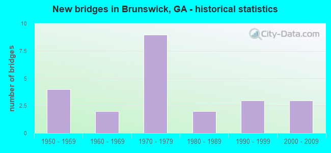
- New bridges - historical statistics
- 41950-1959
- 21960-1969
- 91970-1979
- 21980-1989
- 31990-1999
- 32000-2009

- Reconstructed bridges - Historical Statistics
- 11970-1979
- 31980-1989
- 11990-1999
- 82000-2009


- Bridge Condition - Superstructure
- 26.1%Very good
- 73.9%Good

- Bridge Condition - Substructure
- 69.6%Good
- 21.7%Satisfactory
- 8.7%Fair

- Bridge Condition - Channel
- 88.2%Very good
- 11.8%Good
Find on map >> Show street view
Structure Number: 1270004, Location: 1 MI N OF BRUNSWICK (Lat: 31.183139, Lng: -81.470578), Route carried "on" structure: US 17, Year Built: 1975, Year Reconstructed: 2001, Status: Open, Structure Length: 2.47m (8.10ft), Average Daily Traffic: 28,300 (year 2011), Truck Traffic: 1%, Average Future Daily Traffic: 42,450 (year 2031), Design Load: HS 20, Features Intersected: CYPRESS MILL CREEK
Minimum Vertical Clearance: 30+ m (98+ ft), Kilometerpoint: 22.531, Lanes on structure: 2, Base Highway Network: Yes, Owner: State Highway Agency, Approaching Roadway Width: 12.2m (40.0ft), Skew: 10 degrees, Material/Design: Concrete, Design/Construction: Tee Beam, Number Of Spans In Main Unit: 3, Length of Maximum Span: 8.2m (26.9ft), Curb or Sidewalk Widths: Left: 0.2m (0.7ft), Right: 0.2m (0.7ft), Curb-To-Curb Width: 15.3m (50.2ft), Out-to-Out Width: 16.3m (53.5ft)
Condition: Deck: Good, Superstructure: Good, Substructure: Fair, Channel: Very good, Operating Rating: 49.8 metric tons, Method Used To Determine Operating Rating: Allowable Stress (AS), Inventory Rating: 32.6 metric tons, Method Used To Determine Inventory Rating: Allowable Stress (AS), Structural Evaluation: Somewhat better than minimum adequacy, Deck Geometry: Superior to present desirable criteria, Waterway Adequacy: Equal to present desirable criteria, Approach Roadway Alignment: Equal to present desirable criteria, Designated Inspection Frequency: Every 24 months, Inspection Date: October 2020, Bridge Improvement Cost: $316,000, Roadway Improvement Cost: $32,000, Total Project Cost: $475,000, Deck Structure Type: Concrete Cast-file-Place
Find on map >> Show street view
Structure Number: 1270005, Location: 1 MI N OF BRUNSWICK (Lat: 31.183219, Lng: -81.470858), Route carried "on" structure: US 17, Year Built: 1955, Year Reconstructed: 1975, Status: Open, Structure Length: 2.47m (8.10ft), Average Daily Traffic: 28,300 (year 2011), Truck Traffic: 1%, Average Future Daily Traffic: 42,450 (year 2031), Design Load: HS 20, Features Intersected: CYPRESS MILL CREEK
Minimum Vertical Clearance: 30+ m (98+ ft), Kilometerpoint: 22.531, Lanes on structure: 3, Base Highway Network: Yes, Owner: State Highway Agency, Approaching Roadway Width: 12.2m (40.0ft), Skew: 10 degrees, Material/Design: Concrete, Design/Construction: Tee Beam, Number Of Spans In Main Unit: 3, Length of Maximum Span: 8.2m (26.9ft), Curb or Sidewalk Widths: Left: 0.2m (0.7ft), Right: 0.2m (0.7ft), Curb-To-Curb Width: 16.2m (53.1ft), Out-to-Out Width: 17.3m (56.8ft)
Condition: Deck: Good, Superstructure: Good, Substructure: Fair, Channel: Good, Operating Rating: 51.7 metric tons, Method Used To Determine Operating Rating: Allowable Stress (AS), Inventory Rating: 32.6 metric tons, Method Used To Determine Inventory Rating: Allowable Stress (AS), Structural Evaluation: Somewhat better than minimum adequacy, Deck Geometry: Better than present minimum criteria, Waterway Adequacy: Equal to present desirable criteria, Approach Roadway Alignment: Equal to present desirable criteria, Designated Inspection Frequency: Every 24 months, Inspection Date: October 2020, Bridge Improvement Cost: $403,000, Roadway Improvement Cost: $40,000, Total Project Cost: $604,000, Deck Structure Type: Concrete Cast-file-Place, Wearing Surface/Protective System: Wearing Surface: Bituminous
Find on map >> Show street view
Structure Number: 1270041, Location: 1 MI N OF JCT SR 520 (Lat: 31.153139, Lng: -81.568150), Route carried "on" structure: State highway 303, Year Built: 1965, Status: Open, Structure Length: 35.36m (116.01ft), Average Daily Traffic: 8,690 (year 2012), Truck Traffic: 1%, Average Future Daily Traffic: 13,035 (year 2032), Design Load: HS 20+Mod, Features Intersected: SOUTH BRUNSWICK RIVER
Minimum Vertical Clearance: 30+ m (98+ ft), Kilometerpoint: 1.609, Lanes on structure: 2, Base Highway Network: Yes, Owner: State Highway Agency, Approaching Roadway Width: 8.8m (28.9ft), Material/Design: Steel continuous, Design/Construction: Stringer/Multi-beam, Number Of Spans In Main Unit: 3, Number Of Approach Spans: 15, Length of Maximum Span: 30.5m (100.1ft), Curb or Sidewalk Widths: Left: 0.6m (2.0ft), Right: 0.6m (2.0ft), Curb-To-Curb Width: 8.5m (27.9ft), Out-to-Out Width: 10.4m (34.1ft)
Condition: Deck: Good, Superstructure: Good, Substructure: Satisfactory, Channel: Very good, Operating Rating: 44.4 metric tons, Method Used To Determine Operating Rating: Load Factor (LF), Inventory Rating: 18.1 metric tons, Method Used To Determine Inventory Rating: Load Factor (LF), Structural Evaluation: Meets minimum limits, Deck Geometry: Meets minimum limits, Waterway Adequacy: Equal to present desirable criteria, Approach Roadway Alignment: Equal to present desirable criteria, Designated Inspection Frequency: Every 24 months, Underwater Inspection Frequency: Every 60 months, Other Special Inspection Frequency: Every 12 months, Inspection Date: October 2020, Underwater Inspection Date: June 2018, Other Special Inspection Date: October 2021, Bridge Improvement Cost: $4,532,000, Roadway Improvement Cost: $453,000, Total Project Cost: $6,799,000, Deck Structure Type: Concrete Cast-file-Place, Wearing Surface/Protective System: Wearing Surface: Epoxy Overlay
Find on map >> Show street view
Structure Number: 1270043, Location: .7 MI E OF INT SR 25-303 (Lat: 31.137675, Lng: -81.574825), Route carried "on" structure: Interstate 95, Year Built: 1976, Year Reconstructed: 2006, Status: Open, Structure Length: 7.77m (25.49ft), Average Daily Traffic: 46,410 (year 2011), Truck Traffic: 1%, Average Future Daily Traffic: 69,615 (year 2031), Design Load: HS 20, Features Intersected: SR 520 (US 17)
Minimum Vertical Clearance: 30+ m (98+ ft), Kilometerpoint: 46.671, Lanes on structure: 3, Lanes under structure: 6, Base Highway Network: Yes, Owner: State Highway Agency, Approaching Roadway Width: 18.9m (62.0ft), Skew: 10 degrees, Material/Design: Steel continuous, Design/Construction: Stringer/Multi-beam, Number Of Spans In Main Unit: 4, Length of Maximum Span: 26.8m (87.9ft), Curb-To-Curb Width: 23.3m (76.4ft), Out-to-Out Width: 24.3m (79.7ft)
Condition: Deck: Good, Superstructure: Very good, Substructure: Good, Operating Rating: 58.9 metric tons, Method Used To Determine Operating Rating: Load Factor (LF), Inventory Rating: 35.3 metric tons, Method Used To Determine Inventory Rating: Load Factor (LF), Structural Evaluation: Better than present minimum criteria, Deck Geometry: Superior to present desirable criteria, Underclear: Meets minimum limits, Approach Roadway Alignment: Equal to present desirable criteria, Designated Inspection Frequency: Every 24 months, Inspection Date: October 2020, Bridge Improvement Cost: $1,268,000, Roadway Improvement Cost: $127,000, Total Project Cost: $1,902,000, Deck Structure Type: Concrete Cast-file-Place
Find on map >> Show street view
Structure Number: 1270044, Location: .7 MI E OF INT SR 25-303 (Lat: 31.137828, Lng: -81.575169), Route carried "on" structure: Interstate 95, Year Built: 1976, Year Reconstructed: 2006, Status: Open, Structure Length: 7.74m (25.39ft), Average Daily Traffic: 46,410 (year 2011), Truck Traffic: 1%, Average Future Daily Traffic: 69,615 (year 2031), Design Load: HS 20, Features Intersected: SR 520 - (US 17)
Minimum Vertical Clearance: 30+ m (98+ ft), Kilometerpoint: 46.671, Lanes on structure: 4, Lanes under structure: 6, Base Highway Network: Yes, Owner: State Highway Agency, Approaching Roadway Width: 19.5m (64.0ft), Skew: 10 degrees, Material/Design: Steel continuous, Design/Construction: Stringer/Multi-beam, Number Of Spans In Main Unit: 4, Length of Maximum Span: 26.8m (87.9ft), Curb-To-Curb Width: 30.8m (101.0ft), Out-to-Out Width: 31.7m (104.0ft)
Condition: Deck: Good, Superstructure: Good, Substructure: Good, Operating Rating: 58.0 metric tons, Method Used To Determine Operating Rating: Allowable Stress (AS), Inventory Rating: 32.6 metric tons, Method Used To Determine Inventory Rating: Allowable Stress (AS), Structural Evaluation: Better than present minimum criteria, Deck Geometry: Superior to present desirable criteria, Underclear: Meets minimum limits, Approach Roadway Alignment: Equal to present desirable criteria, Designated Inspection Frequency: Every 24 months, Inspection Date: October 2020, Bridge Improvement Cost: $1,534,000, Roadway Improvement Cost: $153,000, Total Project Cost: $2,301,000, Deck Structure Type: Concrete Cast-file-Place
Find on map >> Show street view
Structure Number: 1270045, Location: 6 MI W OF BRUNSWICK (Lat: 31.142944, Lng: -81.571417), Route carried "on" structure: Interstate 95, Year Built: 1976, Year Reconstructed: 2008, Status: Open, Structure Length: 5.00m (16.40ft), Average Daily Traffic: 46,410 (year 2011), Truck Traffic: 1%, Average Future Daily Traffic: 69,615 (year 2031), Design Load: HS 20, Features Intersected: COLONELS ISLAND-CSX RR
Minimum Vertical Clearance: 30+ m (98+ ft), Kilometerpoint: 48.280, Lanes on structure: 3, Base Highway Network: Yes, Owner: State Highway Agency, Approaching Roadway Width: 27.4m (89.9ft), Skew: 11 degrees, Material/Design: Steel, Design/Construction: Stringer/Multi-beam, Number Of Spans In Main Unit: 3, Length of Maximum Span: 18.0m (59.1ft), Curb-To-Curb Width: 27.6m (90.6ft), Out-to-Out Width: 28.5m (93.5ft)
Condition: Deck: Good, Superstructure: Very good, Substructure: Good, Operating Rating: 58.0 metric tons, Method Used To Determine Operating Rating: Load Factor (LF), Inventory Rating: 34.4 metric tons, Method Used To Determine Inventory Rating: Load Factor (LF), Structural Evaluation: Better than present minimum criteria, Deck Geometry: Superior to present desirable criteria, Underclear: Superior to present desirable criteria, Approach Roadway Alignment: Equal to present desirable criteria, Designated Inspection Frequency: Every 24 months, Inspection Date: December 2020, Bridge Improvement Cost: $816,000, Roadway Improvement Cost: $82,000, Total Project Cost: $1,223,000, Deck Structure Type: Concrete Cast-file-Place
Find on map >> Show street view
Structure Number: 1270046, Location: 6 MI W OF BRUNSWICK (Lat: 31.143042, Lng: -81.571761), Route carried "on" structure: Interstate 95, Year Built: 1976, Year Reconstructed: 2008, Status: Open, Structure Length: 5.03m (16.50ft), Average Daily Traffic: 46,410 (year 2011), Truck Traffic: 1%, Average Future Daily Traffic: 69,615 (year 2031), Design Load: HS 20+Mod, Features Intersected: COLONELS ISLAND-CSX RR
Minimum Vertical Clearance: 30+ m (98+ ft), Kilometerpoint: 48.280, Lanes on structure: 3, Base Highway Network: Yes, Owner: State Highway Agency, Approaching Roadway Width: 21.3m (69.9ft), Skew: 11 degrees, Material/Design: Steel, Design/Construction: Stringer/Multi-beam, Number Of Spans In Main Unit: 3, Length of Maximum Span: 18.0m (59.1ft), Curb or Sidewalk Widths: Left: 0.2m (0.7ft), Right: 0.2m (0.7ft), Curb-To-Curb Width: 25.5m (83.7ft), Out-to-Out Width: 26.4m (86.6ft)
Condition: Deck: Good, Superstructure: Very good, Substructure: Good, Operating Rating: 58.0 metric tons, Method Used To Determine Operating Rating: Load Factor (LF), Inventory Rating: 34.4 metric tons, Method Used To Determine Inventory Rating: Load Factor (LF), Structural Evaluation: Better than present minimum criteria, Deck Geometry: Superior to present desirable criteria, Underclear: Superior to present desirable criteria, Approach Roadway Alignment: Equal to present desirable criteria, Designated Inspection Frequency: Every 24 months, Inspection Date: December 2020, Bridge Improvement Cost: $821,000, Roadway Improvement Cost: $82,000, Total Project Cost: $1,231,000, Deck Structure Type: Concrete Cast-file-Place
Find on map >> Show street view
Structure Number: 1270047, Location: 1.2 MI N I-95 & SR520 INT (Lat: 31.152622, Lng: -81.564131), Route carried "on" structure: Interstate 95, Year Built: 1977, Year Reconstructed: 2008, Status: Open, Structure Length: 56.45m (185.20ft), Average Daily Traffic: 46,410 (year 2011), Truck Traffic: 1%, Average Future Daily Traffic: 69,615 (year 2031), Design Load: HS 20+Mod, Features Intersected: SOUTH BRUNSWICK RIVER
Minimum Vertical Clearance: 30+ m (98+ ft), Kilometerpoint: 48.280, Lanes on structure: 3, Base Highway Network: Yes, Owner: State Highway Agency, Approaching Roadway Width: 22.9m (75.1ft), Skew: 10 degrees, Material/Design: Prestressed concrete, Design/Construction: Stringer/Multi-beam, Number Of Spans In Main Unit: 28, Length of Maximum Span: 28.0m (91.9ft), Curb-To-Curb Width: 23.1m (75.8ft), Out-to-Out Width: 24.1m (79.1ft)
Condition: Deck: Good, Superstructure: Good, Substructure: Good, Channel: Very good, Operating Rating: 62.5 metric tons, Method Used To Determine Operating Rating: Load Factor (LF), Inventory Rating: 31.7 metric tons, Method Used To Determine Inventory Rating: Load Factor (LF), Structural Evaluation: Better than present minimum criteria, Deck Geometry: Superior to present desirable criteria, Waterway Adequacy: Equal to present desirable criteria, Approach Roadway Alignment: Equal to present desirable criteria, Designated Inspection Frequency: Every 24 months, Underwater Inspection Frequency: Every 60 months, Inspection Date: December 2020, Underwater Inspection Date: June 2018, Bridge Improvement Cost: $9,210,000, Roadway Improvement Cost: $921,000, Total Project Cost: $13,814,000, Deck Structure Type: Concrete Cast-file-Place
Find on map >> Show street view
Structure Number: 1270048, Location: 1.2 MI N I-95 & SR520 INT (Lat: 31.152750, Lng: -81.564411), Route carried "on" structure: Interstate 95, Year Built: 1977, Year Reconstructed: 2008, Status: Open, Structure Length: 56.45m (185.20ft), Average Daily Traffic: 46,410 (year 2011), Truck Traffic: 1%, Average Future Daily Traffic: 69,615 (year 2031), Design Load: HS 20+Mod, Features Intersected: SOUTH BRUNSWICK RIVER
Minimum Vertical Clearance: 30+ m (98+ ft), Kilometerpoint: 48.280, Lanes on structure: 3, Base Highway Network: Yes, Owner: State Highway Agency, Approaching Roadway Width: 22.9m (75.1ft), Skew: 10 degrees, Material/Design: Prestressed concrete, Design/Construction: Stringer/Multi-beam, Number Of Spans In Main Unit: 28, Length of Maximum Span: 28.0m (91.9ft), Curb-To-Curb Width: 23.1m (75.8ft), Out-to-Out Width: 24.1m (79.1ft)
Condition: Deck: Good, Superstructure: Good, Substructure: Satisfactory, Channel: Very good, Operating Rating: 56.2 metric tons, Method Used To Determine Operating Rating: Load Factor (LF), Inventory Rating: 32.6 metric tons, Method Used To Determine Inventory Rating: Load Factor (LF), Structural Evaluation: Equal to present minimum criteria, Deck Geometry: Superior to present desirable criteria, Waterway Adequacy: Equal to present desirable criteria, Approach Roadway Alignment: Equal to present desirable criteria, Designated Inspection Frequency: Every 24 months, Underwater Inspection Frequency: Every 60 months, Inspection Date: December 2020, Underwater Inspection Date: June 2018, Bridge Improvement Cost: $9,210,000, Roadway Improvement Cost: $921,000, Total Project Cost: $13,814,000, Deck Structure Type: Concrete Cast-file-Place
Find on map >> Show street view
Structure Number: 1270049, Location: INT I-95 & SR 303 (Lat: 31.166522, Lng: -81.553731), Route carried "on" structure: Interstate 95, Year Built: 1977, Year Reconstructed: 2008, Status: Open, Structure Length: 36.55m (119.91ft), Average Daily Traffic: 46,410 (year 2011), Truck Traffic: 1%, Average Future Daily Traffic: 69,615 (year 2031), Design Load: HS 20+Mod, Features Intersected: SR 303 - HILLERY SLOUGH
Minimum Vertical Clearance: 30+ m (98+ ft), Kilometerpoint: 49.890, Lanes on structure: 3, Lanes under structure: 2, Base Highway Network: Yes, Owner: State Highway Agency, Approaching Roadway Width: 22.6m (74.1ft), Skew: 19 degrees, Material/Design: Steel, Design/Construction: Stringer/Multi-beam, Number Of Spans In Main Unit: 3, Number Of Approach Spans: 12, Length of Maximum Span: 47.5m (155.8ft), Curb-To-Curb Width: 23.2m (76.1ft), Out-to-Out Width: 24.1m (79.1ft)
Condition: Deck: Good, Superstructure: Good, Substructure: Good, Channel: Very good, Operating Rating: 52.6 metric tons, Method Used To Determine Operating Rating: Load Factor (LF), Inventory Rating: 30.8 metric tons, Method Used To Determine Inventory Rating: Load Factor (LF), Structural Evaluation: Better than present minimum criteria, Deck Geometry: Superior to present desirable criteria, Underclear: Better than present minimum criteria, Waterway Adequacy: Equal to present desirable criteria, Approach Roadway Alignment: Equal to present desirable criteria, Designated Inspection Frequency: Every 24 months, Underwater Inspection Frequency: Every 60 months, Inspection Date: November 2020, Underwater Inspection Date: May 2018, Bridge Improvement Cost: $5,962,000, Roadway Improvement Cost: $596,000, Total Project Cost: $8,944,000, Deck Structure Type: Concrete Cast-file-Place
Find on map >> Show street view
Structure Number: 127005, Location: INT OF I-95 AND SR 303 (Lat: 31.166622, Lng: -81.554014), Route carried "on" structure: Interstate 95, Year Built: 1977, Year Reconstructed: 2008, Status: Open, Structure Length: 40.97m (134.42ft), Average Daily Traffic: 46,410 (year 2011), Truck Traffic: 1%, Average Future Daily Traffic: 69,615 (year 2031), Design Load: HS 20+Mod, Features Intersected: SR 303 - HILLERY SLOUGH
Minimum Vertical Clearance: 30+ m (98+ ft), Kilometerpoint: 49.890, Lanes on structure: 3, Lanes under structure: 2, Base Highway Network: Yes, Owner: State Highway Agency, Approaching Roadway Width: 19.2m (63.0ft), Skew: 19 degrees, Material/Design: Steel, Design/Construction: Stringer/Multi-beam, Number Of Spans In Main Unit: 5, Number Of Approach Spans: 12, Length of Maximum Span: 47.9m (157.2ft), Curb-To-Curb Width: 23.1m (75.8ft), Out-to-Out Width: 24.0m (78.7ft)
Condition: Deck: Good, Superstructure: Good, Substructure: Good, Channel: Very good, Operating Rating: 52.6 metric tons, Method Used To Determine Operating Rating: Load Factor (LF), Inventory Rating: 31.7 metric tons, Method Used To Determine Inventory Rating: Load Factor (LF), Structural Evaluation: Better than present minimum criteria, Deck Geometry: Superior to present desirable criteria, Underclear: Better than present minimum criteria, Waterway Adequacy: Superior to present desirable criteria, Approach Roadway Alignment: Equal to present desirable criteria, Designated Inspection Frequency: Every 24 months, Underwater Inspection Frequency: Every 60 months, Inspection Date: November 2020, Underwater Inspection Date: May 2018, Bridge Improvement Cost: $6,683,000, Roadway Improvement Cost: $668,000, Total Project Cost: $10,025,000, Deck Structure Type: Concrete Cast-file-Place
Find on map >> Show street view
Structure Number: 1270061, Location: 3.7 MI E OF BRUNSWICK (Lat: 31.167808, Lng: -81.413428), Route carried "on" structure: State highway 25, Year Built: 1950, Year Reconstructed: 1986, Status: Open, Structure Length: 38.98m (127.89ft), Average Daily Traffic: 22,740 (year 2011), Truck Traffic: 1%, Average Future Daily Traffic: 34,110 (year 2031), Design Load: H 15, Features Intersected: FREDERICA RIVER
Minimum Vertical Clearance: 30+ m (98+ ft), Kilometerpoint: 9.656, Lanes on structure: 4, Base Highway Network: Yes, Owner: State Highway Agency, Approaching Roadway Width: 17.4m (57.1ft), Material/Design: Prestressed concrete, Design/Construction: Stringer/Multi-beam, Number Of Spans In Main Unit: 1, Number Of Approach Spans: 32, Length of Maximum Span: 38.7m (127.0ft), Curb-To-Curb Width: 21.9m (71.9ft), Out-to-Out Width: 23.0m (75.5ft)
Condition: Deck: Good, Superstructure: Good, Substructure: Satisfactory, Channel: Very good, Operating Rating: 89.8 metric tons, Method Used To Determine Operating Rating: Load Factor (LF), Inventory Rating: 29.9 metric tons, Method Used To Determine Inventory Rating: Load Factor (LF), Structural Evaluation: Equal to present minimum criteria, Deck Geometry: Superior to present desirable criteria, Waterway Adequacy: Equal to present desirable criteria, Approach Roadway Alignment: Better than present minimum criteria, Designated Inspection Frequency: Every 24 months, Underwater Inspection Frequency: Every 60 months, Inspection Date: November 2020, Underwater Inspection Date: July 2018, Bridge Improvement Cost: $7,723,000, Roadway Improvement Cost: $772,000, Total Project Cost: $11,585,000, Deck Structure Type: Concrete Cast-file-Place, Wearing Surface/Protective System: Wearing Surface: Bituminous
Find on map >> Show street view
Structure Number: 1270063, Location: 2.2 MI E OF BRUNSWICK (Lat: 31.168814, Lng: -81.436561), Route carried "on" structure: State highway 25, Year Built: 1950, Year Reconstructed: 1986, Status: Open, Structure Length: 22.71m (74.51ft), Average Daily Traffic: 22,740 (year 2011), Truck Traffic: 1%, Average Future Daily Traffic: 34,110 (year 2031), Design Load: H 15, Features Intersected: LITTLE RIVER
Minimum Vertical Clearance: 30+ m (98+ ft), Kilometerpoint: 12.875, Lanes on structure: 4, Base Highway Network: Yes, Owner: State Highway Agency, Approaching Roadway Width: 18.0m (59.1ft), Material/Design: Concrete continuous, Design/Construction: Tee Beam, Number Of Spans In Main Unit: 14, Length of Maximum Span: 17.1m (56.1ft), Curb or Sidewalk Widths: Left: 1.8m (5.9ft), Right: 0.0m, Curb-To-Curb Width: 22.1m (72.5ft), Out-to-Out Width: 25.1m (82.3ft)
Condition: Deck: Good, Superstructure: Good, Substructure: Satisfactory, Channel: Very good, Operating Rating: 30.8 metric tons, Method Used To Determine Operating Rating: Allowable Stress (AS), Inventory Rating: 18.1 metric tons, Method Used To Determine Inventory Rating: Allowable Stress (AS), Structural Evaluation: Meets minimum limits, Deck Geometry: Superior to present desirable criteria, Waterway Adequacy: Equal to present desirable criteria, Approach Roadway Alignment: Equal to present desirable criteria, Designated Inspection Frequency: Every 24 months, Underwater Inspection Frequency: Every 60 months, Inspection Date: November 2020, Underwater Inspection Date: July 2018, Bridge Improvement Cost: $4,499,000, Roadway Improvement Cost: $450,000, Total Project Cost: $6,748,000, Deck Structure Type: Concrete Cast-file-Place, Wearing Surface/Protective System: Wearing Surface: Bituminous
Find on map >> Show street view
Structure Number: 1270064, Location: 1.5 MI E OF BRUNSWICK (Lat: 31.164519, Lng: -81.446069), Route carried "on" structure: State highway 25, Year Built: 1986, Status: Open, Structure Length: 48.37m (158.69ft), Average Daily Traffic: 22,740 (year 2011), Truck Traffic: 1%, Average Future Daily Traffic: 34,110 (year 2031), Design Load: HS 20+Mod, Features Intersected: BACK RIVER
Minimum Vertical Clearance: 30+ m (98+ ft), Kilometerpoint: 14.484, Lanes on structure: 4, Base Highway Network: Yes, Owner: State Highway Agency, Approaching Roadway Width: 17.7m (58.1ft), Navigation Control: Yes ( Vertical Clearance: 12.1m (39.7ft), Horizontal Clearance: 27.4m (89.9ft)), Material/Design: Prestressed concrete, Design/Construction: Stringer/Multi-beam, Number Of Spans In Main Unit: 19, Length of Maximum Span: 36.6m (120.1ft), Curb-To-Curb Width: 21.9m (71.9ft), Out-to-Out Width: 23.0m (75.5ft)
Condition: Deck: Good, Superstructure: Good, Substructure: Good, Channel: Very good, Operating Rating: 89.8 metric tons, Method Used To Determine Operating Rating: Load Factor (LF), Inventory Rating: 39.0 metric tons, Method Used To Determine Inventory Rating: Load Factor (LF), Structural Evaluation: Better than present minimum criteria, Deck Geometry: Superior to present desirable criteria, Waterway Adequacy: Equal to present desirable criteria, Approach Roadway Alignment: Equal to present desirable criteria, Designated Inspection Frequency: Every 24 months, Underwater Inspection Frequency: Every 60 months, Inspection Date: November 2020, Underwater Inspection Date: July 2018, Bridge Improvement Cost: $9,583,000, Roadway Improvement Cost: $958,000, Total Project Cost: $14,374,000, Deck Structure Type: Concrete Cast-file-Place
Find on map >> Show street view
Structure Number: 1270065, Location: .5 MI E OF BRUNSWICK (Lat: 31.161689, Lng: -81.468839), Route carried "on" structure: County highway 582, Year Built: 1950, Year Reconstructed: 1986, Status: Open, Structure Length: 9.88m (32.41ft), Average Daily Traffic: 22,740 (year 2011), Truck Traffic: 1%, Average Future Daily Traffic: 34,110 (year 2031), Design Load: H 15, Features Intersected: TERRY CREEK
Minimum Vertical Clearance: 30+ m (98+ ft), Kilometerpoint: 16.093, Lanes on structure: 4, Base Highway Network: Yes, Owner: State Highway Agency, Approaching Roadway Width: 17.7m (58.1ft), Material/Design: Concrete continuous, Design/Construction: Tee Beam, Number Of Spans In Main Unit: 13, Length of Maximum Span: 11.0m (36.1ft), Curb-To-Curb Width: 21.9m (71.9ft), Out-to-Out Width: 23.0m (75.5ft)
Condition: Deck: Good, Superstructure: Good, Substructure: Good, Channel: Very good, Operating Rating: 69.8 metric tons, Method Used To Determine Operating Rating: Load Factor (LF), Inventory Rating: 41.7 metric tons, Method Used To Determine Inventory Rating: Load Factor (LF), Structural Evaluation: Better than present minimum criteria, Deck Geometry: Superior to present desirable criteria, Waterway Adequacy: Superior to present desirable criteria, Approach Roadway Alignment: Equal to present desirable criteria, Designated Inspection Frequency: Every 24 months, Underwater Inspection Frequency: Every 60 months, Inspection Date: November 2020, Underwater Inspection Date: July 2018, Bridge Improvement Cost: $1,956,000, Roadway Improvement Cost: $196,000, Total Project Cost: $2,935,000, Deck Structure Type: Concrete Cast-file-Place, Wearing Surface/Protective System: Wearing Surface: Bituminous
Find on map >> Show street view
Structure Number: 1270072, Location: 6 MI W JCT SR 303 & SR 25 (Lat: 31.191919, Lng: -81.661028), Route carried "on" structure: US 82, Year Built: 1982, Status: Open, Structure Length: 3.47m (11.38ft), Average Daily Traffic: 9,400 (year 2011), Truck Traffic: 1%, Average Future Daily Traffic: 14,100 (year 2031), Design Load: HS 20+Mod, Features Intersected: COLLEGE CREEK
Minimum Vertical Clearance: 30+ m (98+ ft), Kilometerpoint: 11.265, Lanes on structure: 2, Base Highway Network: Yes, Owner: State Highway Agency, Approaching Roadway Width: 9.4m (30.8ft), Skew: 10 degrees, Material/Design: Prestressed concrete, Design/Construction: Stringer/Multi-beam, Number Of Spans In Main Unit: 3, Length of Maximum Span: 11.6m (38.1ft), Curb-To-Curb Width: 12.8m (42.0ft), Out-to-Out Width: 13.7m (44.9ft)
Condition: Deck: Good, Superstructure: Good, Substructure: Satisfactory, Channel: Very good, Operating Rating: 78.0 metric tons, Method Used To Determine Operating Rating: Load Factor (LF), Inventory Rating: 40.8 metric tons, Method Used To Determine Inventory Rating: Load Factor (LF), Structural Evaluation: Equal to present minimum criteria, Deck Geometry: Equal to present desirable criteria, Waterway Adequacy: Better than present minimum criteria, Approach Roadway Alignment: Equal to present desirable criteria, Designated Inspection Frequency: Every 24 months, Underwater Inspection Frequency: Every 60 months, Inspection Date: October 2020, Underwater Inspection Date: May 2018, Bridge Improvement Cost: $445,000, Roadway Improvement Cost: $45,000, Total Project Cost: $668,000, Deck Structure Type: Concrete Cast-file-Place
Find on map >> Show street view
Structure Number: 1270076, Location: BRUNSWICK - NORTHSIDE (Lat: 31.203269, Lng: -81.501639), Route carried "on" structure: State highway 303, Year Built: 1993, Status: Open, Structure Length: 5.88m (19.29ft), Average Daily Traffic: 15,010 (year 2011), Truck Traffic: 1%, Average Future Daily Traffic: 22,515 (year 2031), Design Load: HS 20+Mod, Features Intersected: CR 1065-CSX RR 729234W
Minimum Vertical Clearance: 30+ m (98+ ft), Kilometerpoint: 11.265, Lanes on structure: 4, Lanes under structure: 2, Base Highway Network: Yes, Owner: State Highway Agency, Approaching Roadway Width: 19.5m (64.0ft), Skew: 9 degrees, Material/Design: Prestressed concrete, Design/Construction: Stringer/Multi-beam, Number Of Spans In Main Unit: 2, Length of Maximum Span: 34.7m (113.8ft), Curb-To-Curb Width: 18.3m (60.0ft), Out-to-Out Width: 19.3m (63.3ft)
Condition: Deck: Good, Superstructure: Very good, Substructure: Good, Operating Rating: 56.2 metric tons, Method Used To Determine Operating Rating: Load Factor (LF), Inventory Rating: 26.3 metric tons, Method Used To Determine Inventory Rating: Load Factor (LF), Structural Evaluation: Equal to present minimum criteria, Deck Geometry: Somewhat better than minimum adequacy, Underclear: Somewhat better than minimum adequacy, Approach Roadway Alignment: Equal to present desirable criteria, Designated Inspection Frequency: Every 24 months, Inspection Date: December 2020, Bridge Improvement Cost: $1,165,000, Roadway Improvement Cost: $117,000, Total Project Cost: $1,748,000, Deck Structure Type: Concrete Cast-file-Place
Find on map >> Show street view
Structure Number: 1270078, Location: 5 MI S OF BRUNSWICK (Lat: 31.127278, Lng: -81.552497), Route carried "on" structure: US 17, Year Built: 1996, Status: Open, Structure Length: 18.93m (62.11ft), Average Daily Traffic: 11,830 (year 2011), Truck Traffic: 8%, Average Future Daily Traffic: 17,745 (year 2031), Design Load: HS 20+Mod, Features Intersected: FANCY BLUFF CREEK
Minimum Vertical Clearance: 30+ m (98+ ft), Kilometerpoint: 8.047, Lanes on structure: 2, Base Highway Network: Yes, Owner: State Highway Agency, Approaching Roadway Width: 8.8m (28.9ft), Skew: 10 degrees, Material/Design: Prestressed concrete, Design/Construction: Stringer/Multi-beam, Number Of Spans In Main Unit: 7, Length of Maximum Span: 36.6m (120.1ft), Curb-To-Curb Width: 11.6m (38.1ft), Out-to-Out Width: 12.6m (41.3ft)
Condition: Deck: Good, Superstructure: Good, Substructure: Good, Channel: Very good, Operating Rating: 68.9 metric tons, Method Used To Determine Operating Rating: Load Factor (LF), Inventory Rating: 37.1 metric tons, Method Used To Determine Inventory Rating: Load Factor (LF), Structural Evaluation: Better than present minimum criteria, Deck Geometry: Better than present minimum criteria, Waterway Adequacy: Equal to present desirable criteria, Approach Roadway Alignment: Equal to present desirable criteria, Designated Inspection Frequency: Every 24 months, Underwater Inspection Frequency: Every 60 months, Other Special Inspection Frequency: Every 12 months, Inspection Date: October 2020, Underwater Inspection Date: June 2018, Other Special Inspection Date: October 2021, Bridge Improvement Cost: $2,426,000, Roadway Improvement Cost: $243,000, Total Project Cost: $3,640,000, Deck Structure Type: Concrete Cast-file-Place
Find on map >> Show street view
Structure Number: 1275001, Location: 2 MI E SR 25-SR 405 INT (Lat: 31.138206, Lng: -81.558067), Route carried "on" structure: County highway 20, Year Built: 1962, Status: Posted for load, Structure Length: 1.83m (6.00ft), Average Daily Traffic: 1,000 (year 2011), Truck Traffic: 1%, Average Future Daily Traffic: 1,500 (year 2031), Design Load: H 15, Features Intersected: FANCY BLUFF CREEK TRIB
Minimum Vertical Clearance: 30+ m (98+ ft), Kilometerpoint: 0.000, Lanes on structure: 2, Base Highway Network: Yes, Owner: County Highway Agency, Approaching Roadway Width: 7.0m (23.0ft), Material/Design: Concrete, Design/Construction: Tee Beam, Number Of Spans In Main Unit: 2, Length of Maximum Span: 9.1m (29.9ft), Curb or Sidewalk Widths: Left: 0.6m (2.0ft), Right: 0.6m (2.0ft), Curb-To-Curb Width: 7.3m (24.0ft), Out-to-Out Width: 9.2m (30.2ft)
Condition: Deck: Good, Superstructure: Good, Substructure: Good, Channel: Good, Operating Rating: 48.0 metric tons, Method Used To Determine Operating Rating: Load Factor (LF), Inventory Rating: 28.1 metric tons, Method Used To Determine Inventory Rating: Load Factor (LF), Structural Evaluation: Better than present minimum criteria, Deck Geometry: Meets minimum limits, Waterway Adequacy: Equal to present desirable criteria, Approach Roadway Alignment: Equal to present desirable criteria, Designated Inspection Frequency: Every 24 months, Inspection Date: October 2020, Bridge Improvement Cost: $234,000, Roadway Improvement Cost: $23,000, Total Project Cost: $352,000, Deck Structure Type: Concrete Cast-file-Place
Find on map >> Show street view
Structure Number: 1275018, Location: 5 MI S OF BRUNSWICK (Lat: 31.127119, Lng: -81.552658), Route carried "on" structure: US 17, Year Built: 1997, Status: Open, Structure Length: 18.90m (62.01ft), Average Daily Traffic: 11,830 (year 2011), Truck Traffic: 8%, Average Future Daily Traffic: 17,745 (year 2031), Design Load: HS 20+Mod, Features Intersected: FANCY BLUFF CREEK, Facility Carried by Structure: SR 520 EBL
Minimum Vertical Clearance: 30+ m (98+ ft), Kilometerpoint: 8.047, Lanes on structure: 2, Base Highway Network: Yes, Owner: State Highway Agency, Approaching Roadway Width: 9.1m (29.9ft), Skew: 10 degrees, Material/Design: Prestressed concrete, Design/Construction: Stringer/Multi-beam, Number Of Spans In Main Unit: 7, Length of Maximum Span: 36.6m (120.1ft), Curb-To-Curb Width: 11.6m (38.1ft), Out-to-Out Width: 12.6m (41.3ft)
Condition: Deck: Good, Superstructure: Very good, Substructure: Good, Channel: Very good, Operating Rating: 63.5 metric tons, Method Used To Determine Operating Rating: Load Factor (LF), Inventory Rating: 29.9 metric tons, Method Used To Determine Inventory Rating: Load Factor (LF), Structural Evaluation: Better than present minimum criteria, Deck Geometry: Better than present minimum criteria, Waterway Adequacy: Equal to present desirable criteria, Approach Roadway Alignment: Equal to present desirable criteria, Designated Inspection Frequency: Every 24 months, Underwater Inspection Frequency: Every 60 months, Other Special Inspection Frequency: Every 12 months, Inspection Date: October 2020, Underwater Inspection Date: June 2018, Other Special Inspection Date: October 2021, Bridge Improvement Cost: $2,422,000, Roadway Improvement Cost: $242,000, Total Project Cost: $3,634,000, Deck Structure Type: Concrete Cast-file-Place
Find on map >> Show street view
Structure Number: 127502, Location: 0.5 S BRUNSWICK CTY LMTS (Lat: 31.116236, Lng: -81.485344), Route carried "on" structure: US 25, Year Built: 2002, Status: Open, Structure Length: 237.13m (777.99ft), Average Daily Traffic: 11,950 (year 2011), Truck Traffic: 6%, Average Future Daily Traffic: 17,925 (year 2031), Design Load: HS 20+Mod, Features Intersected: BRUNSWICK RIVER, Facility Carried by Structure: SIDNEY LANIER BRID
Minimum Vertical Clearance: 30+ m (98+ ft), Kilometerpoint: 14.484, Lanes on structure: 4, Lanes under structure: 4, Base Highway Network: Yes, Owner: State Highway Agency, Approaching Roadway Width: 18.9m (62.0ft), Skew: 30 degrees, Navigation Control: Yes ( Vertical Clearance: 56.3m (184.7ft), Horizontal Clearance: 304.4m (998.7ft)), Material/Design: Prestressed concrete, Design/Construction: Stayed Girder, Number Of Spans In Main Unit: 3, Number Of Approach Spans: 34, Length of Maximum Span: 381.0m (1,250.0ft), Curb-To-Curb Width: 20.7m (67.9ft), Out-to-Out Width: 22.6m (74.1ft)
Condition: Deck: Good, Superstructure: Good, Substructure: Good, Channel: Very good, Operating Rating: 55.3 metric tons, Method Used To Determine Operating Rating: Load Factor (LF), Inventory Rating: 39.0 metric tons, Method Used To Determine Inventory Rating: Load Factor (LF), Structural Evaluation: Better than present minimum criteria, Deck Geometry: Superior to present desirable criteria, Underclear: High priority of corrective action, Waterway Adequacy: Equal to present desirable criteria, Approach Roadway Alignment: Equal to present desirable criteria, Designated Inspection Frequency: Every 24 months, Underwater Inspection Frequency: Every 60 months, Inspection Date: December 2020, Underwater Inspection Date: September 2018, Bridge Improvement Cost: $46,979,000, Roadway Improvement Cost: $4,698,000, Total Project Cost: $70,468,000, Deck Structure Type: Concrete Cast-file-Place
Find on map >> Show street view
Structure Number: 1275021, Location: 1.5 MILES E. OF JCT. SR 2 (Lat: 31.088689, Lng: -81.479669), Route carried "on" structure: State highway 520, Year Built: 2005, Status: Open, Structure Length: 9.14m (29.99ft), Average Daily Traffic: 3,440 (year 2011), Truck Traffic: 9%, Average Future Daily Traffic: 5,160 (year 2031), Design Load: HS 20+Mod, Features Intersected: CEDAR CREEK, Facility Carried by Structure: JEKYLL ISLAND ROAD
Minimum Vertical Clearance: 30+ m (98+ ft), Kilometerpoint: 32.187, Lanes on structure: 2, Base Highway Network: Yes, Owner: State Highway Agency, Approaching Roadway Width: 9.1m (29.9ft), Skew: 3 degrees, Material/Design: Prestressed concrete, Design/Construction: Stringer/Multi-beam, Number Of Spans In Main Unit: 5, Length of Maximum Span: 18.3m (60.0ft), Curb-To-Curb Width: 13.4m (44.0ft), Out-to-Out Width: 14.4m (47.2ft)
Condition: Deck: Good, Superstructure: Very good, Substructure: Good, Channel: Very good, Operating Rating: 81.6 metric tons, Method Used To Determine Operating Rating: Load Factor (LF), Inventory Rating: 40.8 metric tons, Method Used To Determine Inventory Rating: Load Factor (LF), Structural Evaluation: Better than present minimum criteria, Deck Geometry: Better than present minimum criteria, Waterway Adequacy: Equal to present desirable criteria, Approach Roadway Alignment: Equal to present desirable criteria, Designated Inspection Frequency: Every 24 months, Underwater Inspection Frequency: Every 60 months, Inspection Date: December 2020, Underwater Inspection Date: May 2018, Bridge Improvement Cost: $1,172,000, Roadway Improvement Cost: $117,000, Total Project Cost: $1,758,000, Deck Structure Type: Concrete Cast-file-Place
Find on map >> Show street view
Structure Number: 1275022, Location: 5 MI S OF BRUNSWICK (Lat: 31.120747, Lng: -81.543142), Route carried "on" structure: US 25, Year Built: 2007, Status: Open, Structure Length: 15.24m (50.00ft), Average Daily Traffic: 3,440 (year 2011), Truck Traffic: 9%, Average Future Daily Traffic: 5,160 (year 2031), Design Load: HS 20+Mod, Features Intersected: PORT AUTHORITY
Minimum Vertical Clearance: 30+ m (98+ ft), Kilometerpoint: 8.047, Lanes on structure: 4, Lanes under structure: 2, Base Highway Network: Yes, Owner: State Highway Agency, Approaching Roadway Width: 22.9m (75.1ft), Skew: 7 degrees, Material/Design: Prestressed concrete, Design/Construction: Stringer/Multi-beam, Number Of Spans In Main Unit: 6, Length of Maximum Span: 30.5m (100.1ft), Curb-To-Curb Width: 21.9m (71.9ft), Out-to-Out Width: 23.0m (75.5ft)
Condition: Deck: Good, Superstructure: Good, Substructure: Good, Operating Rating: 68.9 metric tons, Method Used To Determine Operating Rating: Allowable Stress (AS), Inventory Rating: 37.1 metric tons, Method Used To Determine Inventory Rating: Allowable Stress (AS), Structural Evaluation: Better than present minimum criteria, Deck Geometry: Superior to present desirable criteria, Underclear: Meets minimum limits, Approach Roadway Alignment: Equal to present desirable criteria, Designated Inspection Frequency: Every 24 months, Inspection Date: October 2020, Bridge Improvement Cost: $3,019,000, Roadway Improvement Cost: $302,000, Total Project Cost: $4,529,000, Deck Structure Type: Concrete Cast-file-Place
Find on map >> Show street view
Structure Number: 1270043, Location: .7 MI E OF INT SR 25-303 (Lat: 31.137675, Lng: -81.574825), Route carried "under" structure: US 17, Structure Length: 0. m, Average Daily Traffic: 8,200 (year 1999), Truck Traffic: 1%, Features Intersected: I-95 NBL (SR 405), Facility Carried by Structure: I-95 NBL
Minimum Vertical Clearance: 5.15m (16.90ft), Kilometerpoint: 20.921, Lanes on structure: 3, Length of Maximum Span: 0.0m
Find on map >> Show street view
Structure Number: 1270044, Location: .7 MI E OF INT SR 25-303 (Lat: 31.137828, Lng: -81.575169), Route carried "under" structure: US 17, Structure Length: 0. m, Average Daily Traffic: 8,200 (year 1999), Truck Traffic: 1%, Features Intersected: I-95 SBL (SR 405), Facility Carried by Structure: I-95 SBL & RAMP
Minimum Vertical Clearance: 5.13m (16.83ft), Kilometerpoint: 20.921, Lanes on structure: 4, Length of Maximum Span: 0.0m
Find on map >> Show street view
Structure Number: 1270049, Location: INT I-95 & SR 303 (Lat: 31.166522, Lng: -81.553731), Route carried "under" structure: State highway 303, Structure Length: 0. m, Average Daily Traffic: 42,700 (year 2000), Truck Traffic: 24%, Features Intersected: I-95 NBL (SR 405), Facility Carried by Structure: I-95 NBL
Minimum Vertical Clearance: 5.15m (16.90ft), Kilometerpoint: 3.219, Lanes on structure: 3, Length of Maximum Span: 0.0m
Find on map >> Show street view
Structure Number: 127005, Location: INT OF I-95 AND SR 303 (Lat: 31.166622, Lng: -81.554014), Route carried "under" structure: State highway 303, Structure Length: 0. m, Average Daily Traffic: 42,700 (year 2000), Truck Traffic: 24%, Features Intersected: I-95 SBL (SR 405), Facility Carried by Structure: I-95 SBL
Minimum Vertical Clearance: 5.02m (16.47ft), Kilometerpoint: 3.219, Lanes on structure: 3, Length of Maximum Span: 0.0m
Find on map >> Show street view
Structure Number: 1270076, Location: BRUNSWICK - NORTHSIDE (Lat: 31.203269, Lng: -81.501639), Route carried "under" structure: City street 1065, Structure Length: 0. m, Average Daily Traffic: 15,600 (year 1999), Truck Traffic: 1%, Features Intersected: SR 303, Facility Carried by Structure: SR 303
Minimum Vertical Clearance: 6.90m (22.64ft), Kilometerpoint: 0.000, Lanes on structure: 4, Length of Maximum Span: 0.0m
Find on map >> Show street view
Structure Number: 127502, Location: 0.5 S BRUNSWICK CTY LMTS (Lat: 31.116236, Lng: -81.485344), Route carried "under" structure: City street 99999, Structure Length: 0. m, Average Daily Traffic: 100 (year 2006), Truck Traffic: 1%, Features Intersected: LANIER BRIDGE, Facility Carried by Structure: SIDNEY LANIER BRID
Minimum Vertical Clearance: 5.38m (17.65ft), Kilometerpoint: 0.000, Lanes on structure: 4, Length of Maximum Span: 0.0m
Find on map >> Show street view
Structure Number: 127502, Location: 0.5 S BRUNSWICK CTY LMTS (Lat: 31.116236, Lng: -81.485344), Route carried "under" structure: State lands road , Structure Length: 0. m, Average Daily Traffic: 100 (year 2006), Truck Traffic: 1%, Features Intersected: DNR ROAD., Facility Carried by Structure: SIDNEY LANIER BRID
Minimum Vertical Clearance: 5.05m (16.57ft), Kilometerpoint: 0.000, Lanes on structure: 4, Length of Maximum Span: 0.0m
Find on map >> Show street view
Structure Number: 1275022, Location: 5 MI S OF BRUNSWICK (Lat: 31.120747, Lng: -81.543142), Route carried "under" structure: State highway 520, Structure Length: 0. m, Average Daily Traffic: 500 (year 2005), Truck Traffic: 1%, Features Intersected: PORT AVTHOURTY
Minimum Vertical Clearance: 7.13m (23.39ft), Kilometerpoint: 8.047, Lanes on structure: 4, Length of Maximum Span: 0.0m