Bridge Statistics for Brawley, California (CA)
Condition, Traffic, Stress, Structural Evaluation, Project Costs
- National Bridge Inventory (NBI) Statistics
- 40Number of bridges
- 545ft / 166mTotal length
- $738,000Total costs
- 157,511Total average daily traffic
- 21,977Total average daily truck traffic
- National Bridge Inventory (NBI) Registered Bridges for Brawley
- No street view available for this location
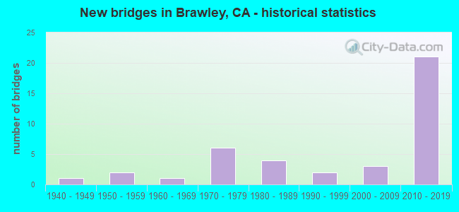
- New bridges - historical statistics
- 11940-1949
- 21950-1959
- 11960-1969
- 61970-1979
- 41980-1989
- 21990-1999
- 32000-2009
- 212010-2019


- Bridge Condition - Deck
- 33.3%Good
- 3.3%Satisfactory
- 56.7%Fair
- 6.7%Poor

- Bridge Condition - Superstructure
- 66.7%Good
- 3.3%Satisfactory
- 26.7%Fair
- 3.3%Poor

- Bridge Condition - Substructure
- 80.0%Good
- 16.7%Fair
- 3.3%Poor

- Bridge Condition - Channel
- 4.3%Excellent
- 69.6%Very good
- 21.7%Satisfactory
- 4.3%Fair
Find on map >> Show street view
Structure Number: 58 0006R, Location: 11-IMP-086-17.86 (Lat: 32.949122, Lng: -115.568994), Route carried "on" structure: State highway 86, Year Built: 1982, Status: Open, Structure Length: 5.27m (17.29ft), Average Daily Traffic: 7,700 (year 2018), Average Future Daily Traffic: 14,330 (year 2040), Design Load: HS 20+Mod, Features Intersected: CENTRAL MAIN CANAL
Minimum Vertical Clearance: 30+ m (98+ ft), Kilometerpoint: 17.860, Lanes on structure: 2, Base Highway Network: Yes (, Subroute: 1), Owner: State Highway Agency, Approaching Roadway Width: 11.1m (36.4ft), Skew: 6 degrees, Material/Design: Prestressed concrete continuous, Design/Construction: Box Beam or Girders - Multiple, Number Of Spans In Main Unit: 3, Length of Maximum Span: 21.3m (69.9ft), Curb-To-Curb Width: 11.1m (36.4ft), Out-to-Out Width: 12.3m (40.4ft)
Condition: Deck: Good, Superstructure: Good, Substructure: Good, Channel: Excellent, Operating Rating: 54.1 metric tons, Method Used To Determine Operating Rating: Assigned rating based on Load Factor Design (LFD) reported in metric tons, Inventory Rating: 32.4 metric tons, Method Used To Determine Inventory Rating: Assigned rating based on Load Factor Design (LFD) reported in metric tons, Structural Evaluation: Better than present minimum criteria, Deck Geometry: Equal to present minimum criteria, Waterway Adequacy: Equal to present minimum criteria, Approach Roadway Alignment: Meets minimum limits, Designated Inspection Frequency: Every 48 months, Inspection Date: January 2022, Deck Structure Type: Concrete Cast-file-Place, Wearing Surface/Protective System: Wearing Surface: Monolithic Concrete
Find on map >> Show street view
Structure Number: 58 0019L, Location: 11-IMP-086-R22.93 (Lat: 32.985422, Lng: -115.578678), Route carried "on" structure: State highway 86, Year Built: 1998, Status: Open, Structure Length: 4.20m (13.78ft), Average Daily Traffic: 5,700 (year 2018), Truck Traffic: 29%, Average Future Daily Traffic: 10,236 (year 2040), Design Load: HS 20+Mod, Features Intersected: TAMARACK (WESTSIDE MAIN)
Minimum Vertical Clearance: 30+ m (98+ ft), Kilometerpoint: 22.930, Lanes on structure: 3, Base Highway Network: Yes (, Subroute: 1), Owner: State Highway Agency, Approaching Roadway Width: 15.8m (51.8ft), Skew: 5 degrees, Material/Design: Prestressed concrete, Design/Construction: Box Beam or Girders - Multiple, Number Of Spans In Main Unit: 2, Length of Maximum Span: 21.0m (68.9ft), Curb-To-Curb Width: 15.8m (51.8ft), Out-to-Out Width: 16.9m (55.4ft)
Condition: Deck: Good, Superstructure: Good, Substructure: Good, Channel: Very good, Operating Rating: 54.1 metric tons, Method Used To Determine Operating Rating: Assigned rating based on Load Factor Design (LFD) reported in metric tons, Inventory Rating: 32.4 metric tons, Method Used To Determine Inventory Rating: Assigned rating based on Load Factor Design (LFD) reported in metric tons, Structural Evaluation: Better than present minimum criteria, Deck Geometry: Better than present minimum criteria, Waterway Adequacy: Equal to present desirable criteria, Approach Roadway Alignment: Equal to present desirable criteria, Designated Inspection Frequency: Every 24 months, Inspection Date: January 2022, Deck Structure Type: Concrete Cast-file-Place
Find on map >> Show street view
Structure Number: 58 0019R, Location: 11-IMP-086-R22.96 (Lat: 32.986050, Lng: -115.578714), Route carried "on" structure: State highway 86, Year Built: 1962, Status: Open, Structure Length: 2.44m (8.01ft), Average Daily Traffic: 5,700 (year 2018), Truck Traffic: 29%, Average Future Daily Traffic: 10,236 (year 2040), Design Load: HS 20, Features Intersected: TAMARACK (WESTSIDE MAIN)
Minimum Vertical Clearance: 30+ m (98+ ft), Kilometerpoint: 22.960, Lanes on structure: 2, Base Highway Network: Yes (, Subroute: 1), Owner: State Highway Agency, Approaching Roadway Width: 12.2m (40.0ft), Skew: 5 degrees, Material/Design: Prestressed concrete, Design/Construction: Box Beam or Girders - Multiple, Number Of Spans In Main Unit: 2, Length of Maximum Span: 11.9m (39.0ft), Curb-To-Curb Width: 12.2m (40.0ft), Out-to-Out Width: 13.0m (42.7ft)
Condition: Deck: Good, Superstructure: Good, Substructure: Good, Channel: Fair, Operating Rating: 75.8 metric tons, Method Used To Determine Operating Rating: Load Factor (LF), Inventory Rating: 32.4 metric tons, Method Used To Determine Inventory Rating: Load Factor (LF), Structural Evaluation: Better than present minimum criteria, Deck Geometry: Better than present minimum criteria, Waterway Adequacy: Equal to present desirable criteria, Approach Roadway Alignment: Equal to present desirable criteria, Designated Inspection Frequency: Every 24 months, Inspection Date: January 2022, Deck Structure Type: Concrete Precast Panels, Wearing Surface/Protective System: Wearing Surface: Bituminous
Find on map >> Show street view
Structure Number: 58 0118, Location: 11-IMP-078-17.48 (Lat: 32.978642, Lng: -115.466944), Route carried "on" structure: State highway 78, Year Built: 1982, Status: Open, Structure Length: 5.18m (16.99ft), Average Daily Traffic: 4,300 (year 2011), Truck Traffic: 34%, Average Future Daily Traffic: 11,185 (year 2039), Design Load: HS 20, Features Intersected: ALAMO RIVER
Minimum Vertical Clearance: 30+ m (98+ ft), Kilometerpoint: 17.480, Lanes on structure: 2, Base Highway Network: Yes (, Subroute: 1), Owner: State Highway Agency, Approaching Roadway Width: 12.3m (40.4ft), Material/Design: Concrete continuous, Design/Construction: Slab, Number Of Spans In Main Unit: 5, Length of Maximum Span: 11.3m (37.1ft), Curb or Sidewalk Widths: Left: 0.2m (0.7ft), Right: 0.2m (0.7ft), Curb-To-Curb Width: 12.3m (40.4ft), Out-to-Out Width: 13.3m (43.6ft)
Condition: Deck: Satisfactory, Superstructure: Satisfactory, Substructure: Good, Channel: Very good, Operating Rating: 87.5 metric tons, Method Used To Determine Operating Rating: Load Factor (LF), Inventory Rating: 52.5 metric tons, Method Used To Determine Inventory Rating: Load Factor (LF), Structural Evaluation: Equal to present minimum criteria, Deck Geometry: Equal to present minimum criteria, Waterway Adequacy: Equal to present desirable criteria, Approach Roadway Alignment: Superior to present desirable criteria, Designated Inspection Frequency: Every 24 months, Underwater Inspection Frequency: Every 60 months, Inspection Date: December 2020, Underwater Inspection Date: December 2020, Deck Structure Type: Concrete Cast-file-Place
Find on map >> Show street view
Structure Number: 58 012, Location: 11-IMP-111-23.91 (Lat: 33.004606, Lng: -115.526528), Route carried "on" structure: State highway 111, Year Built: 1978, Status: Open, Structure Length: 4.17m (13.68ft), Average Daily Traffic: 5,800 (year 2011), Truck Traffic: 18%, Average Future Daily Traffic: 12,613 (year 2038), Design Load: HS 20+Mod, Features Intersected: NEW RIVER
Minimum Vertical Clearance: 30+ m (98+ ft), Kilometerpoint: 23.910, Lanes on structure: 2, Base Highway Network: Yes (Inventory Route: 1, Subroute: 1), Owner: State Highway Agency, Approaching Roadway Width: 12.2m (40.0ft), Skew: 2 degrees, Material/Design: Concrete continuous, Design/Construction: Slab, Number Of Spans In Main Unit: 5, Length of Maximum Span: 9.1m (29.9ft), Curb-To-Curb Width: 12.2m (40.0ft), Out-to-Out Width: 13.3m (43.6ft)
Condition: Deck: Good, Superstructure: Good, Substructure: Good, Channel: Satisfactory, Operating Rating: 89.7 metric tons, Method Used To Determine Operating Rating: Load Factor (LF), Inventory Rating: 53.8 metric tons, Method Used To Determine Inventory Rating: Load Factor (LF), Structural Evaluation: Better than present minimum criteria, Deck Geometry: Somewhat better than minimum adequacy, Waterway Adequacy: Equal to present desirable criteria, Approach Roadway Alignment: Equal to present desirable criteria, Designated Inspection Frequency: Every 24 months, Underwater Inspection Frequency: Every 60 months, Inspection Date: August 2021, Underwater Inspection Date: November 2019, Deck Structure Type: Concrete Cast-file-Place
Find on map >> Show street view
Structure Number: 58 0183, Location: 11-IMP-111-26.95 (Lat: 33.048703, Lng: -115.526708), Route carried "on" structure: State highway 111, Year Built: 1985, Status: Open, Structure Length: 4.57m (14.99ft), Average Daily Traffic: 6,600 (year 2011), Truck Traffic: 18%, Average Future Daily Traffic: 12,620 (year 2038), Design Load: HS 20+Mod, Features Intersected: NEW RIVER
Minimum Vertical Clearance: 30+ m (98+ ft), Kilometerpoint: 26.950, Lanes on structure: 2, Base Highway Network: Yes (Inventory Route: 1, Subroute: 1), Owner: State Highway Agency, Approaching Roadway Width: 12.2m (40.0ft), Skew: 1 degrees, Material/Design: Prestressed concrete, Design/Construction: Box Beam or Girders - Multiple, Number Of Spans In Main Unit: 1, Length of Maximum Span: 44.3m (145.3ft), Curb-To-Curb Width: 12.2m (40.0ft), Out-to-Out Width: 13.1m (43.0ft)
Condition: Deck: Good, Superstructure: Good, Substructure: Good, Channel: Very good, Operating Rating: 54.1 metric tons, Method Used To Determine Operating Rating: Assigned rating based on Load Factor Design (LFD) reported in metric tons, Inventory Rating: 32.4 metric tons, Method Used To Determine Inventory Rating: Assigned rating based on Load Factor Design (LFD) reported in metric tons, Structural Evaluation: Better than present minimum criteria, Deck Geometry: Somewhat better than minimum adequacy, Waterway Adequacy: Equal to present desirable criteria, Approach Roadway Alignment: Equal to present desirable criteria, Designated Inspection Frequency: Every 24 months, Inspection Date: August 2021, Deck Structure Type: Concrete Cast-file-Place
Find on map >> Show street view
Structure Number: 58 0329, Location: 11-IMP-086-21.57 (Lat: 32.978981, Lng: -115.557650), Route carried "on" structure: State highway 86, Year Built: 2001, Status: Open, Structure Length: 9.02m (29.59ft), Average Daily Traffic: 13,700 (year 2021), Truck Traffic: 5%, Average Future Daily Traffic: 20,471 (year 2040), Design Load: HS 20+Mod, Features Intersected: NEW RIVER
Minimum Vertical Clearance: 30+ m (98+ ft), Kilometerpoint: 21.570, Lanes on structure: 4, Base Highway Network: Yes (, Subroute: 1), Owner: State Highway Agency, Approaching Roadway Width: 27.5m (90.2ft), Skew: 12 degrees, Material/Design: Prestressed concrete continuous, Design/Construction: Box Beam or Girders - Multiple, Number Of Spans In Main Unit: 3, Length of Maximum Span: 37.8m (124.0ft), Curb-To-Curb Width: 27.5m (90.2ft), Out-to-Out Width: 28.5m (93.5ft)
Condition: Deck: Good, Superstructure: Good, Substructure: Good, Channel: Satisfactory, Operating Rating: 54.1 metric tons, Method Used To Determine Operating Rating: Assigned rating based on Load Factor Design (LFD) reported in metric tons, Inventory Rating: 32.4 metric tons, Method Used To Determine Inventory Rating: Assigned rating based on Load Factor Design (LFD) reported in metric tons, Structural Evaluation: Better than present minimum criteria, Deck Geometry: Superior to present desirable criteria, Waterway Adequacy: Equal to present desirable criteria, Approach Roadway Alignment: Equal to present desirable criteria, Designated Inspection Frequency: Every 24 months, Inspection Date: January 2022, Deck Structure Type: Concrete Cast-file-Place
Find on map >> Show street view
Structure Number: 58 0335L, Location: 11-IMP-111-R20.58 (Lat: 32.956142, Lng: -115.509194), Route carried "on" structure: State highway 111, Year Built: 2003, Status: Open, Structure Length: 1.20m (3.94ft), Average Daily Traffic: 6,450 (year 2011), Truck Traffic: 25%, Average Future Daily Traffic: 24,911 (year 2038), Design Load: HS 20+Mod, Features Intersected: ROCKWOOD CANAL
Minimum Vertical Clearance: 30+ m (98+ ft), Kilometerpoint: 20.580, Lanes on structure: 2, Base Highway Network: Yes (Inventory Route: 1, Subroute: 1), Owner: State Highway Agency, Approaching Roadway Width: 11.7m (38.4ft), Material/Design: Concrete, Design/Construction: Slab, Number Of Spans In Main Unit: 1, Length of Maximum Span: 11.5m (37.7ft), Curb-To-Curb Width: 11.7m (38.4ft), Out-to-Out Width: 12.6m (41.3ft)
Condition: Deck: Fair, Superstructure: Fair, Substructure: Good, Channel: Satisfactory, Operating Rating: 54.1 metric tons, Method Used To Determine Operating Rating: Assigned rating based on Load Factor Design (LFD) reported in metric tons, Inventory Rating: 32.4 metric tons, Method Used To Determine Inventory Rating: Assigned rating based on Load Factor Design (LFD) reported in metric tons, Structural Evaluation: Somewhat better than minimum adequacy, Deck Geometry: Better than present minimum criteria, Waterway Adequacy: Equal to present desirable criteria, Approach Roadway Alignment: Equal to present desirable criteria, Designated Inspection Frequency: Every 24 months, Inspection Date: August 2021, Deck Structure Type: Concrete Cast-file-Place
Find on map >> Show street view
Structure Number: 58 0335R, Location: 11-IMP-111-R20.58 (Lat: 32.956183, Lng: -115.508903), Route carried "on" structure: State highway 111, Year Built: 2003, Status: Open, Structure Length: 1.20m (3.94ft), Average Daily Traffic: 6,450 (year 2011), Truck Traffic: 25%, Average Future Daily Traffic: 24,911 (year 2038), Design Load: HS 20+Mod, Features Intersected: ROCKWOOD CANAL
Minimum Vertical Clearance: 30+ m (98+ ft), Kilometerpoint: 20.580, Lanes on structure: 2, Base Highway Network: Yes (Inventory Route: 1, Subroute: 1), Owner: State Highway Agency, Approaching Roadway Width: 11.7m (38.4ft), Material/Design: Concrete, Design/Construction: Slab, Number Of Spans In Main Unit: 1, Length of Maximum Span: 11.5m (37.7ft), Curb-To-Curb Width: 11.7m (38.4ft), Out-to-Out Width: 12.6m (41.3ft)
Condition: Deck: Fair, Superstructure: Fair, Substructure: Good, Channel: Satisfactory, Operating Rating: 54.1 metric tons, Method Used To Determine Operating Rating: Assigned rating based on Load Factor Design (LFD) reported in metric tons, Inventory Rating: 32.4 metric tons, Method Used To Determine Inventory Rating: Assigned rating based on Load Factor Design (LFD) reported in metric tons, Structural Evaluation: Somewhat better than minimum adequacy, Deck Geometry: Better than present minimum criteria, Waterway Adequacy: Equal to present desirable criteria, Approach Roadway Alignment: Equal to present desirable criteria, Designated Inspection Frequency: Every 24 months, Inspection Date: August 2021, Deck Structure Type: Concrete Cast-file-Place
Find on map >> Show street view
Structure Number: 58 0337L, Location: 11-IMP-078-R12.48 (Lat: 33.002281, Lng: -115.532614), Route carried "on" structure: State highway 78, Year Built: 2012, Status: Open, Structure Length: 9.31m (30.54ft), Average Daily Traffic: 6,100 (year 2019), Truck Traffic: 5%, Average Future Daily Traffic: 14,200 (year 2041), Design Load: HS 20+Mod, Features Intersected: NEW RIVER
Minimum Vertical Clearance: 30+ m (98+ ft), Kilometerpoint: 12.480, Lanes on structure: 2, Base Highway Network: Yes, Owner: State Highway Agency, Approaching Roadway Width: 12.2m (40.0ft), Skew: 1 degrees, Material/Design: Prestressed concrete, Design/Construction: Stringer/Multi-beam, Number Of Spans In Main Unit: 3, Length of Maximum Span: 35.1m (115.2ft), Curb-To-Curb Width: 12.2m (40.0ft), Out-to-Out Width: 13.1m (43.0ft)
Condition: Deck: Fair, Superstructure: Good, Substructure: Good, Channel: Very good, Operating Rating: 54.1 metric tons, Method Used To Determine Operating Rating: Assigned rating based on Load Factor Design (LFD) reported in metric tons, Inventory Rating: 32.4 metric tons, Method Used To Determine Inventory Rating: Assigned rating based on Load Factor Design (LFD) reported in metric tons, Structural Evaluation: Better than present minimum criteria, Deck Geometry: Better than present minimum criteria, Waterway Adequacy: Equal to present desirable criteria, Approach Roadway Alignment: Equal to present desirable criteria, Designated Inspection Frequency: Every 24 months, Inspection Date: December 2020, Deck Structure Type: Concrete Cast-file-Place
Find on map >> Show street view
Structure Number: 58 0337R, Location: 11-IMP-078-R12.48 (Lat: 33.001958, Lng: -115.532803), Route carried "on" structure: State highway 78, Year Built: 2012, Status: Open, Structure Length: 9.32m (30.58ft), Average Daily Traffic: 6,100 (year 2019), Truck Traffic: 5%, Average Future Daily Traffic: 14,200 (year 2041), Design Load: HS 20+Mod, Features Intersected: NEW RIVER
Minimum Vertical Clearance: 30+ m (98+ ft), Kilometerpoint: 12.480, Lanes on structure: 2, Base Highway Network: Yes, Owner: State Highway Agency, Approaching Roadway Width: 11.7m (38.4ft), Skew: 1 degrees, Material/Design: Prestressed concrete, Design/Construction: Stringer/Multi-beam, Number Of Spans In Main Unit: 3, Length of Maximum Span: 35.1m (115.2ft), Curb-To-Curb Width: 11.7m (38.4ft), Out-to-Out Width: 12.6m (41.3ft)
Condition: Deck: Good, Superstructure: Good, Substructure: Good, Channel: Very good, Operating Rating: 54.1 metric tons, Method Used To Determine Operating Rating: Assigned rating based on Load Factor Design (LFD) reported in metric tons, Inventory Rating: 32.4 metric tons, Method Used To Determine Inventory Rating: Assigned rating based on Load Factor Design (LFD) reported in metric tons, Structural Evaluation: Better than present minimum criteria, Deck Geometry: Better than present minimum criteria, Waterway Adequacy: Equal to present desirable criteria, Approach Roadway Alignment: Equal to present desirable criteria, Designated Inspection Frequency: Every 24 months, Inspection Date: December 2020, Deck Structure Type: Concrete Cast-file-Place
Find on map >> Show street view
Structure Number: 58 0338L, Location: 11-IMP-078-R12.87 (Lat: 33.000708, Lng: -115.526314), Route carried "on" structure: State highway 78, Year Built: 2011, Status: Open, Structure Length: 8.12m (26.64ft), Average Daily Traffic: 6,100 (year 2019), Truck Traffic: 5%, Average Future Daily Traffic: 14,235 (year 2041), Design Load: HS 20+Mod, Features Intersected: STATE ROUTE 111
Minimum Vertical Clearance: 30+ m (98+ ft), Kilometerpoint: 12.870, Lanes on structure: 2, Lanes under structure: 6, Base Highway Network: Yes, Owner: State Highway Agency, Approaching Roadway Width: 11.7m (38.4ft), Material/Design: Prestressed concrete continuous, Design/Construction: Box Beam or Girders - Multiple, Number Of Spans In Main Unit: 3, Length of Maximum Span: 32.7m (107.3ft), Curb-To-Curb Width: 11.7m (38.4ft), Out-to-Out Width: 12.6m (41.3ft)
Condition: Deck: Fair, Superstructure: Good, Substructure: Good, Operating Rating: 54.1 metric tons, Method Used To Determine Operating Rating: Assigned rating based on Load Factor Design (LFD) reported in metric tons, Inventory Rating: 32.4 metric tons, Method Used To Determine Inventory Rating: Assigned rating based on Load Factor Design (LFD) reported in metric tons, Structural Evaluation: Better than present minimum criteria, Deck Geometry: Better than present minimum criteria, Underclear: Somewhat better than minimum adequacy, Approach Roadway Alignment: Equal to present desirable criteria, Designated Inspection Frequency: Every 24 months, Inspection Date: December 2020, Deck Structure Type: Concrete Cast-file-Place
Find on map >> Show street view
Structure Number: 58 0338R, Location: 11-IMP-078-R12.87 (Lat: 33.000356, Lng: -115.526278), Route carried "on" structure: State highway 78, Year Built: 2011, Status: Open, Structure Length: 8.12m (26.64ft), Average Daily Traffic: 6,100 (year 2019), Truck Traffic: 5%, Average Future Daily Traffic: 14,235 (year 2041), Design Load: HS 20+Mod, Features Intersected: STATE ROUTE 111
Minimum Vertical Clearance: 30+ m (98+ ft), Kilometerpoint: 12.870, Lanes on structure: 3, Lanes under structure: 5, Base Highway Network: Yes, Owner: State Highway Agency, Approaching Roadway Width: 15.4m (50.5ft), Material/Design: Prestressed concrete continuous, Design/Construction: Box Beam or Girders - Multiple, Number Of Spans In Main Unit: 3, Length of Maximum Span: 32.7m (107.3ft), Curb-To-Curb Width: 15.4m (50.5ft), Out-to-Out Width: 17.2m (56.4ft)
Condition: Deck: Fair, Superstructure: Good, Substructure: Good, Operating Rating: 54.1 metric tons, Method Used To Determine Operating Rating: Assigned rating based on Load Factor Design (LFD) reported in metric tons, Inventory Rating: 32.4 metric tons, Method Used To Determine Inventory Rating: Assigned rating based on Load Factor Design (LFD) reported in metric tons, Structural Evaluation: Better than present minimum criteria, Deck Geometry: Equal to present minimum criteria, Underclear: Somewhat better than minimum adequacy, Approach Roadway Alignment: Equal to present desirable criteria, Designated Inspection Frequency: Every 24 months, Inspection Date: December 2020, Deck Structure Type: Concrete Cast-file-Place
Find on map >> Show street view
Structure Number: 58 0339S, Location: 11-IMP-078-R12.87 (Lat: 33.000861, Lng: -115.526353), Route carried "on" structure: Ramp State highway 78, Year Built: 2011, Status: Open, Structure Length: 8.14m (26.71ft), Average Daily Traffic: 1,001 (year 2019), Truck Traffic: 5%, Average Future Daily Traffic: 2,080 (year 2041), Design Load: HS 20+Mod, Features Intersected: STATE ROUTE 111
Minimum Vertical Clearance: 30+ m (98+ ft), Kilometerpoint: 12.870, Lanes on structure: 1, Lanes under structure: 6, Base Highway Network: Yes, Owner: State Highway Agency, Approaching Roadway Width: 7.2m (23.6ft), Material/Design: Prestressed concrete continuous, Design/Construction: Box Beam or Girders - Multiple, Number Of Spans In Main Unit: 3, Length of Maximum Span: 32.8m (107.6ft), Curb-To-Curb Width: 7.2m (23.6ft), Out-to-Out Width: 8.1m (26.6ft)
Condition: Deck: Fair, Superstructure: Good, Substructure: Good, Operating Rating: 54.1 metric tons, Method Used To Determine Operating Rating: Assigned rating based on Load Factor Design (LFD) reported in metric tons, Inventory Rating: 32.4 metric tons, Method Used To Determine Inventory Rating: Assigned rating based on Load Factor Design (LFD) reported in metric tons, Structural Evaluation: Better than present minimum criteria, Deck Geometry: Equal to present minimum criteria, Underclear: Somewhat better than minimum adequacy, Approach Roadway Alignment: Equal to present desirable criteria, Designated Inspection Frequency: Every 24 months, Inspection Date: December 2020, Deck Structure Type: Concrete Cast-file-Place
Find on map >> Show street view
Structure Number: 58 0340L, Location: 11-IMP-078-R13.10 (Lat: 33.000611, Lng: -115.522258), Route carried "on" structure: State highway 78, Year Built: 2011, Status: Open, Structure Length: 9.00m (29.53ft), Average Daily Traffic: 6,800 (year 2019), Truck Traffic: 34%, Average Future Daily Traffic: 12,201 (year 2041), Design Load: HS 20+Mod, Features Intersected: BRAWLEY OH
Minimum Vertical Clearance: 30+ m (98+ ft), Kilometerpoint: 13.100, Lanes on structure: 2, Base Highway Network: Yes, Owner: State Highway Agency, Approaching Roadway Width: 11.7m (38.4ft), Skew: 1 degrees, Material/Design: Prestressed concrete continuous, Design/Construction: Box Beam or Girders - Multiple, Number Of Spans In Main Unit: 3, Length of Maximum Span: 40.0m (131.2ft), Curb-To-Curb Width: 11.7m (38.4ft), Out-to-Out Width: 12.6m (41.3ft)
Condition: Deck: Fair, Superstructure: Good, Substructure: Good, Operating Rating: 54.1 metric tons, Method Used To Determine Operating Rating: Assigned rating based on Load Factor Design (LFD) reported in metric tons, Inventory Rating: 32.4 metric tons, Method Used To Determine Inventory Rating: Assigned rating based on Load Factor Design (LFD) reported in metric tons, Structural Evaluation: Better than present minimum criteria, Deck Geometry: Better than present minimum criteria, Underclear: Superior to present desirable criteria, Approach Roadway Alignment: Equal to present desirable criteria, Designated Inspection Frequency: Every 24 months, Inspection Date: December 2020, Deck Structure Type: Concrete Cast-file-Place
Find on map >> Show street view
Structure Number: 58 0340R, Location: 11-IMP-078-R13.10 (Lat: 33.000253, Lng: -115.522383), Route carried "on" structure: State highway 78, Year Built: 2011, Status: Open, Structure Length: 9.00m (29.53ft), Average Daily Traffic: 6,800 (year 2019), Truck Traffic: 34%, Average Future Daily Traffic: 12,201 (year 2041), Design Load: HS 20+Mod, Features Intersected: BRAWLEY OH
Minimum Vertical Clearance: 30+ m (98+ ft), Kilometerpoint: 13.100, Lanes on structure: 2, Base Highway Network: Yes, Owner: State Highway Agency, Approaching Roadway Width: 11.7m (38.4ft), Skew: 1 degrees, Material/Design: Prestressed concrete continuous, Design/Construction: Box Beam or Girders - Multiple, Number Of Spans In Main Unit: 3, Length of Maximum Span: 40.0m (131.2ft), Curb-To-Curb Width: 11.7m (38.4ft), Out-to-Out Width: 12.6m (41.3ft)
Condition: Deck: Poor, Superstructure: Good, Substructure: Good, Operating Rating: 54.1 metric tons, Method Used To Determine Operating Rating: Assigned rating based on Load Factor Design (LFD) reported in metric tons, Inventory Rating: 32.4 metric tons, Method Used To Determine Inventory Rating: Assigned rating based on Load Factor Design (LFD) reported in metric tons, Structural Evaluation: Better than present minimum criteria, Deck Geometry: Better than present minimum criteria, Underclear: Superior to present desirable criteria, Approach Roadway Alignment: Equal to present desirable criteria, Designated Inspection Frequency: Every 24 months, Inspection Date: December 2020, Deck Structure Type: Concrete Cast-file-Place
Find on map >> Show street view
Structure Number: 58 0341L, Location: 11-IMP-078-R13.34 (Lat: 33.000500, Lng: -115.518000), Route carried "on" structure: State highway 78, Year Built: 2011, Status: Open, Structure Length: 10.29m (33.76ft), Average Daily Traffic: 6,800 (year 2019), Truck Traffic: 5%, Average Future Daily Traffic: 12,201 (year 2041), Design Load: HS 20+Mod, Features Intersected: BRAWLEY BEEF WAY AVENUE
Minimum Vertical Clearance: 30+ m (98+ ft), Kilometerpoint: 13.340, Lanes on structure: 2, Lanes under structure: 2, Base Highway Network: Yes, Owner: State Highway Agency, Approaching Roadway Width: 11.7m (38.4ft), Material/Design: Prestressed concrete continuous, Design/Construction: Box Beam or Girders - Multiple, Number Of Spans In Main Unit: 2, Length of Maximum Span: 51.5m (169.0ft), Curb-To-Curb Width: 11.7m (38.4ft), Out-to-Out Width: 12.6m (41.3ft)
Condition: Deck: Fair, Superstructure: Good, Substructure: Good, Operating Rating: 54.1 metric tons, Method Used To Determine Operating Rating: Assigned rating based on Load Factor Design (LFD) reported in metric tons, Inventory Rating: 32.4 metric tons, Method Used To Determine Inventory Rating: Assigned rating based on Load Factor Design (LFD) reported in metric tons, Structural Evaluation: Better than present minimum criteria, Deck Geometry: Better than present minimum criteria, Underclear: Equal to present minimum criteria, Approach Roadway Alignment: Equal to present desirable criteria, Designated Inspection Frequency: Every 24 months, Inspection Date: December 2020, Deck Structure Type: Concrete Cast-file-Place
Find on map >> Show street view
Structure Number: 58 0341R, Location: 11-IMP-078-R13.34 (Lat: 33.000156, Lng: -115.518067), Route carried "on" structure: State highway 78, Year Built: 2011, Status: Open, Structure Length: 10.29m (33.76ft), Average Daily Traffic: 6,800 (year 2019), Truck Traffic: 5%, Average Future Daily Traffic: 12,201 (year 2041), Design Load: HS 20+Mod, Features Intersected: BRAWEY BEEF WAY AVENUE
Minimum Vertical Clearance: 30+ m (98+ ft), Kilometerpoint: 13.340, Lanes on structure: 2, Lanes under structure: 2, Base Highway Network: Yes, Owner: State Highway Agency, Approaching Roadway Width: 11.7m (38.4ft), Material/Design: Prestressed concrete continuous, Design/Construction: Box Beam or Girders - Multiple, Number Of Spans In Main Unit: 2, Length of Maximum Span: 51.5m (169.0ft), Curb-To-Curb Width: 11.7m (38.4ft), Out-to-Out Width: 12.6m (41.3ft)
Condition: Deck: Fair, Superstructure: Good, Substructure: Good, Operating Rating: 54.1 metric tons, Method Used To Determine Operating Rating: Assigned rating based on Load Factor Design (LFD) reported in metric tons, Inventory Rating: 32.4 metric tons, Method Used To Determine Inventory Rating: Assigned rating based on Load Factor Design (LFD) reported in metric tons, Structural Evaluation: Better than present minimum criteria, Deck Geometry: Better than present minimum criteria, Underclear: Equal to present minimum criteria, Approach Roadway Alignment: Equal to present desirable criteria, Designated Inspection Frequency: Every 24 months, Inspection Date: December 2020, Deck Structure Type: Concrete Cast-file-Place
Find on map >> Show street view
Structure Number: 58 0344L, Location: 11-IMP-078-R9.83 (Lat: 33.000394, Lng: -115.578769), Route carried "on" structure: State highway 78, Year Built: 2012, Status: Open, Structure Length: 8.60m (28.22ft), Average Daily Traffic: 4,500 (year 2019), Truck Traffic: 5%, Average Future Daily Traffic: 12,200 (year 2041), Design Load: HS 20+Mod, Features Intersected: KALIN RD, WESTSIDE MAIN
Minimum Vertical Clearance: 30+ m (98+ ft), Kilometerpoint: 9.830, Lanes on structure: 2, Lanes under structure: 2, Base Highway Network: Yes, Owner: State Highway Agency, Approaching Roadway Width: 11.7m (38.4ft), Material/Design: Prestressed concrete continuous, Design/Construction: Box Beam or Girders - Multiple, Number Of Spans In Main Unit: 2, Length of Maximum Span: 52.0m (170.6ft), Curb-To-Curb Width: 11.7m (38.4ft), Out-to-Out Width: 12.6m (41.3ft)
Condition: Deck: Fair, Superstructure: Good, Substructure: Good, Channel: Very good, Operating Rating: 54.1 metric tons, Method Used To Determine Operating Rating: Assigned rating based on Load Factor Design (LFD) reported in metric tons, Inventory Rating: 32.4 metric tons, Method Used To Determine Inventory Rating: Assigned rating based on Load Factor Design (LFD) reported in metric tons, Structural Evaluation: Better than present minimum criteria, Deck Geometry: Better than present minimum criteria, Underclear: Equal to present minimum criteria, Waterway Adequacy: Equal to present desirable criteria, Approach Roadway Alignment: Equal to present desirable criteria, Designated Inspection Frequency: Every 24 months, Inspection Date: December 2020, Deck Structure Type: Concrete Cast-file-Place
Find on map >> Show street view
Structure Number: 58 0344R, Location: 11-IMP-078-R9.83 (Lat: 33.000053, Lng: -115.578767), Route carried "on" structure: State highway 78, Year Built: 2012, Status: Open, Structure Length: 8.60m (28.22ft), Average Daily Traffic: 4,500 (year 2019), Truck Traffic: 5%, Average Future Daily Traffic: 12,200 (year 2041), Design Load: HS 20+Mod, Features Intersected: KALIN RD, WESTSIDE MAIN
Minimum Vertical Clearance: 30+ m (98+ ft), Kilometerpoint: 9.830, Lanes on structure: 2, Lanes under structure: 2, Base Highway Network: Yes, Owner: State Highway Agency, Approaching Roadway Width: 11.7m (38.4ft), Material/Design: Prestressed concrete continuous, Design/Construction: Box Beam or Girders - Multiple, Number Of Spans In Main Unit: 2, Length of Maximum Span: 52.0m (170.6ft), Curb-To-Curb Width: 11.7m (38.4ft), Out-to-Out Width: 12.6m (41.3ft)
Condition: Deck: Fair, Superstructure: Good, Substructure: Fair, Channel: Very good, Operating Rating: 54.1 metric tons, Method Used To Determine Operating Rating: Assigned rating based on Load Factor Design (LFD) reported in metric tons, Inventory Rating: 32.4 metric tons, Method Used To Determine Inventory Rating: Assigned rating based on Load Factor Design (LFD) reported in metric tons, Structural Evaluation: Somewhat better than minimum adequacy, Deck Geometry: Better than present minimum criteria, Underclear: Equal to present minimum criteria, Waterway Adequacy: Equal to present desirable criteria, Approach Roadway Alignment: Equal to present desirable criteria, Designated Inspection Frequency: Every 24 months, Inspection Date: December 2020, Deck Structure Type: Concrete Cast-file-Place
Find on map >> Show street view
Structure Number: 58C0017, Location: 1.6 MI N/O RUTHERFORD RD (Lat: 33.067353, Lng: -115.509661), Route carried "on" structure: County highway , Year Built: 1970, Status: Open, Structure Length: 2.99m (9.81ft), Average Daily Traffic: 800 (year 2019), Truck Traffic: 2%, Average Future Daily Traffic: 1,065 (year 2041), Design Load: HS 20, Features Intersected: ALAMO RIVER, Facility Carried by Structure: KERSHAW RD
Minimum Vertical Clearance: 30+ m (98+ ft), Kilometerpoint: 0.000, Lanes on structure: 2, Owner: County Highway Agency, Approaching Roadway Width: 7.0m (23.0ft), Skew: 1 degrees, Material/Design: Concrete continuous, Design/Construction: Slab, Number Of Spans In Main Unit: 3, Length of Maximum Span: 9.8m (32.2ft), Curb-To-Curb Width: 9.8m (32.2ft), Out-to-Out Width: 9.9m (32.5ft)
Condition: Deck: Poor, Superstructure: Poor, Substructure: Fair, Channel: Very good, Operating Rating: 68.7 metric tons, Method Used To Determine Operating Rating: Load Factor (LF), Inventory Rating: 41.5 metric tons, Method Used To Determine Inventory Rating: Load Factor (LF), Structural Evaluation: Meets minimum limits, Deck Geometry: Equal to present minimum criteria, Waterway Adequacy: Better than present minimum criteria, Approach Roadway Alignment: Equal to present desirable criteria, Length Of Structure Improvement: 2.99m (9.81ft), Designated Inspection Frequency: Every 24 months, Underwater Inspection Frequency: Every 60 months, Inspection Date: December 2021, Underwater Inspection Date: December 2020, Bridge Improvement Cost: $297,000, Roadway Improvement Cost: $59,000, Total Project Cost: $498,000 ( Estimate for 2021), Deck Structure Type: Concrete Cast-file-Place
Find on map >> Show street view
Structure Number: 58C0019, Location: 2.3 MI W/O STATE RTE 115 (Lat: 33.044556, Lng: -115.488556), Route carried "on" structure: County highway , Year Built: 1979, Status: Open, Structure Length: 4.48m (14.70ft), Average Daily Traffic: 1,000 (year 2019), Truck Traffic: 2%, Average Future Daily Traffic: 1,291 (year 2041), Design Load: HS 20, Features Intersected: ALAMO RIVER, Facility Carried by Structure: RUTHERFORD RD(S26)
Minimum Vertical Clearance: 30+ m (98+ ft), Kilometerpoint: 0.000, Lanes on structure: 2, Owner: County Highway Agency, Approaching Roadway Width: 6.4m (21.0ft), Skew: 1 degrees, Material/Design: Concrete continuous, Design/Construction: Slab, Number Of Spans In Main Unit: 4, Length of Maximum Span: 11.0m (36.1ft), Curb-To-Curb Width: 9.8m (32.2ft), Out-to-Out Width: 9.9m (32.5ft)
Condition: Deck: Fair, Superstructure: Fair, Substructure: Good, Channel: Very good, Operating Rating: 90.4 metric tons, Method Used To Determine Operating Rating: Load Factor (LF), Inventory Rating: 54.4 metric tons, Method Used To Determine Inventory Rating: Load Factor (LF), Structural Evaluation: Somewhat better than minimum adequacy, Deck Geometry: Equal to present minimum criteria, Waterway Adequacy: Equal to present desirable criteria, Approach Roadway Alignment: Equal to present desirable criteria, Designated Inspection Frequency: Every 24 months, Underwater Inspection Frequency: Every 60 months, Inspection Date: December 2021, Underwater Inspection Date: December 2020, Deck Structure Type: Concrete Cast-file-Place
Find on map >> Show street view
Structure Number: 58C0022, Location: 0.05 MI E/O SR 111 (Lat: 33.044503, Lng: -115.526458), Route carried "on" structure: County highway , Year Built: 1977, Status: Open, Structure Length: 5.09m (16.70ft), Average Daily Traffic: 1,100 (year 2019), Truck Traffic: 3%, Average Future Daily Traffic: 1,599 (year 2041), Design Load: HS 20, Features Intersected: NEW RIVER, Facility Carried by Structure: RUTHERFORD RD(S26)
Minimum Vertical Clearance: 30+ m (98+ ft), Kilometerpoint: 0.000, Lanes on structure: 2, Owner: County Highway Agency, Approaching Roadway Width: 7.3m (24.0ft), Material/Design: Concrete continuous, Design/Construction: Box Beam or Girders - Multiple, Number Of Spans In Main Unit: 3, Length of Maximum Span: 20.1m (65.9ft), Curb-To-Curb Width: 9.6m (31.5ft), Out-to-Out Width: 9.8m (32.2ft)
Condition: Deck: Fair, Superstructure: Good, Substructure: Good, Channel: Very good, Operating Rating: 62.9 metric tons, Method Used To Determine Operating Rating: Load and Resistance Factor Rating (LRFR) rating reported by rating factor(RF) method using HL-93 loadings, Inventory Rating: 48.6 metric tons, Method Used To Determine Inventory Rating: Load and Resistance Factor Rating (LRFR) rating reported by rating factor(RF) method using HL-93 loadings, Structural Evaluation: Better than present minimum criteria, Deck Geometry: Somewhat better than minimum adequacy, Waterway Adequacy: Superior to present desirable criteria, Approach Roadway Alignment: Equal to present desirable criteria, Designated Inspection Frequency: Every 24 months, Underwater Inspection Frequency: Every 60 months, Inspection Date: December 2021, Underwater Inspection Date: November 2019, Deck Structure Type: Concrete Cast-file-Place
Find on map >> Show street view
Structure Number: 58C0083, Location: 0.37 MI S/O SR 86 & KALIN (Lat: 32.979164, Lng: -115.578878), Route carried "on" structure: County highway , Year Built: 1975, Status: Open, Structure Length: 1.71m (5.61ft), Average Daily Traffic: 1,150 (year 2019), Truck Traffic: 2%, Average Future Daily Traffic: 1,636 (year 2041), Design Load: HS 20, Features Intersected: WESTSIDE MAIN CANAL, Facility Carried by Structure: CADY RD
Minimum Vertical Clearance: 30+ m (98+ ft), Kilometerpoint: 0.000, Lanes on structure: 2, Owner: County Highway Agency, Approaching Roadway Width: 7.3m (24.0ft), Material/Design: Concrete continuous, Design/Construction: Slab, Number Of Spans In Main Unit: 2, Length of Maximum Span: 8.2m (26.9ft), Curb-To-Curb Width: 9.8m (32.2ft), Out-to-Out Width: 9.9m (32.5ft)
Condition: Deck: Fair, Superstructure: Fair, Substructure: Good, Channel: Very good, Operating Rating: 99.8 metric tons, Method Used To Determine Operating Rating: Load Factor (LF), Inventory Rating: 60.9 metric tons, Method Used To Determine Inventory Rating: Load Factor (LF), Structural Evaluation: Somewhat better than minimum adequacy, Deck Geometry: Somewhat better than minimum adequacy, Waterway Adequacy: Superior to present desirable criteria, Approach Roadway Alignment: Equal to present desirable criteria, Designated Inspection Frequency: Every 24 months, Inspection Date: December 2021, Deck Structure Type: Concrete Cast-file-Place
Find on map >> Show street view
Structure Number: 58C0139, Location: 20 FT E/O AUSTIN RD (Lat: 32.934231, Lng: -115.586367), Route carried "on" structure: County highway , Year Built: 1950, Status: Posted for load, Structure Length: 1.89m (6.20ft), Average Daily Traffic: 100 (year 2019), Average Future Daily Traffic: 110 (year 2041), Features Intersected: CENTRAL MAIN CANAL, Facility Carried by Structure: WEAVER RD
Minimum Vertical Clearance: 30+ m (98+ ft), Kilometerpoint: 0.000, Lanes on structure: 2, Owner: County Highway Agency, Approaching Roadway Width: 7.6m (24.9ft), Skew: 4 degrees, Material/Design: Wood or Timber, Design/Construction: Stringer/Multi-beam, Number Of Spans In Main Unit: 4, Length of Maximum Span: 4.6m (15.1ft), Curb or Sidewalk Widths: Left: 0.2m (0.7ft), Right: 0.2m (0.7ft), Curb-To-Curb Width: 7.4m (24.3ft), Out-to-Out Width: 7.8m (25.6ft)
Condition: Deck: Good, Superstructure: Fair, Substructure: Poor, Channel: Very good, Operating Rating: 5.8 metric tons, Method Used To Determine Operating Rating: Allowable Stress (AS), Inventory Rating: 2.7 metric tons, Method Used To Determine Inventory Rating: Allowable Stress (AS), Structural Evaluation: High priority of corrective action, Deck Geometry: Equal to present minimum criteria, Waterway Adequacy: Better than present minimum criteria, Approach Roadway Alignment: Equal to present desirable criteria, Bridge Posting: Required (Relationship of Operating Rating to Maximum Legal Load: 20.0 - 29.9% below), Length Of Structure Improvement: 1.89m (6.20ft), Designated Inspection Frequency: Every 12 months, Underwater Inspection Frequency: Every 24 months, Inspection Date: March 2021, Underwater Inspection Date: January 2022, Bridge Improvement Cost: $143,000, Roadway Improvement Cost: $28,000, Total Project Cost: $240,000 ( Estimate for 2018), Deck Structure Type: Wood or Timber, Wearing Surface/Protective System: Wearing Surface: Bituminous
Find on map >> Show street view
Structure Number: 58C0141, Location: 1.1 MI W/O SR 115 (Lat: 33.001094, Lng: -115.468117), Route carried "on" structure: County highway , Year Built: 1992, Status: Open, Structure Length: 4.48m (14.70ft), Average Daily Traffic: 1,000 (year 2019), Truck Traffic: 2%, Average Future Daily Traffic: 1,308 (year 2041), Design Load: HS 20, Features Intersected: ALAMO RIVER, Facility Carried by Structure: SHANK ROAD
Minimum Vertical Clearance: 30+ m (98+ ft), Kilometerpoint: 0.000, Lanes on structure: 2, Owner: County Highway Agency, Approaching Roadway Width: 7.3m (24.0ft), Material/Design: Concrete continuous, Design/Construction: Slab, Number Of Spans In Main Unit: 4, Length of Maximum Span: 11.0m (36.1ft), Curb-To-Curb Width: 9.8m (32.2ft), Out-to-Out Width: 10.4m (34.1ft)
Condition: Deck: Fair, Superstructure: Fair, Substructure: Good, Channel: Very good, Operating Rating: 54.1 metric tons, Method Used To Determine Operating Rating: Assigned rating based on Load Factor Design (LFD) reported in metric tons, Inventory Rating: 32.4 metric tons, Method Used To Determine Inventory Rating: Assigned rating based on Load Factor Design (LFD) reported in metric tons, Structural Evaluation: Somewhat better than minimum adequacy, Deck Geometry: Equal to present minimum criteria, Waterway Adequacy: Superior to present desirable criteria, Approach Roadway Alignment: Equal to present desirable criteria, Designated Inspection Frequency: Every 24 months, Underwater Inspection Frequency: Every 60 months, Inspection Date: December 2021, Underwater Inspection Date: December 2020, Deck Structure Type: Concrete Cast-file-Place
Find on map >> Show street view
Structure Number: 58C0161, Location: 0.28 MI S/O SR 78 EXPWY (Lat: 32.997275, Lng: -115.543883), Route carried "on" structure: County highway , Year Built: 1989, Status: Open, Structure Length: 4.21m (13.81ft), Average Daily Traffic: 3,500 (year 2019), Truck Traffic: 2%, Average Future Daily Traffic: 4,304 (year 2041), Design Load: HS 20+Mod, Features Intersected: NEW RIVER, Facility Carried by Structure: HOVLEY RD
Minimum Vertical Clearance: 30+ m (98+ ft), Kilometerpoint: 0.000, Lanes on structure: 2, Owner: County Highway Agency, Approaching Roadway Width: 8.2m (26.9ft), Material/Design: Concrete continuous, Design/Construction: Slab, Number Of Spans In Main Unit: 4, Length of Maximum Span: 10.4m (34.1ft), Curb-To-Curb Width: 9.8m (32.2ft), Out-to-Out Width: 10.4m (34.1ft)
Condition: Deck: Fair, Superstructure: Fair, Substructure: Fair, Channel: Satisfactory, Operating Rating: 54.1 metric tons, Method Used To Determine Operating Rating: Assigned rating based on Load Factor Design (LFD) reported in metric tons, Inventory Rating: 32.4 metric tons, Method Used To Determine Inventory Rating: Assigned rating based on Load Factor Design (LFD) reported in metric tons, Structural Evaluation: Somewhat better than minimum adequacy, Deck Geometry: Meets minimum limits, Waterway Adequacy: Superior to present desirable criteria, Approach Roadway Alignment: Equal to present desirable criteria, Designated Inspection Frequency: Every 24 months, Underwater Inspection Frequency: Every 60 months, Inspection Date: December 2021, Underwater Inspection Date: November 2019, Deck Structure Type: Concrete Cast-file-Place
Find on map >> Show street view
Structure Number: 58C0174, Location: 20 FT S/O CARTER RD (Lat: 32.940819, Lng: -115.600869), Route carried "on" structure: County highway , Year Built: 1940, Status: Open, Structure Length: 1.40m (4.59ft), Average Daily Traffic: 80 (year 2016), Truck Traffic: 1%, Average Future Daily Traffic: 107 (year 2038), Features Intersected: WESTSIDE MAIN CANAL, Facility Carried by Structure: FITES RD
Minimum Vertical Clearance: 30+ m (98+ ft), Kilometerpoint: 0.000, Lanes on structure: 2, Owner: County Highway Agency, Approaching Roadway Width: 7.3m (24.0ft), Material/Design: Wood or Timber, Design/Construction: Stringer/Multi-beam, Number Of Spans In Main Unit: 3, Length of Maximum Span: 4.6m (15.1ft), Curb-To-Curb Width: 7.5m (24.6ft), Out-to-Out Width: 7.8m (25.6ft)
Condition: Deck: Good, Superstructure: Good, Substructure: Fair, Channel: Very good, Operating Rating: 28.8 metric tons, Method Used To Determine Operating Rating: Allowable Stress (AS), Inventory Rating: 19.8 metric tons, Method Used To Determine Inventory Rating: Allowable Stress (AS), Structural Evaluation: Somewhat better than minimum adequacy, Deck Geometry: Equal to present minimum criteria, Waterway Adequacy: Superior to present desirable criteria, Approach Roadway Alignment: Somewhat better than minimum adequacy, Designated Inspection Frequency: Every 24 months, Inspection Date: December 2021, Deck Structure Type: Wood or Timber, Wearing Surface/Protective System: Wearing Surface: Bituminous
Find on map >> Show street view
Structure Number: 58C0175, Location: 40 FT S/O CARTER (Lat: 32.935406, Lng: -115.612483), Route carried "on" structure: County highway , Year Built: 1950, Status: Open, Structure Length: 1.86m (6.10ft), Average Daily Traffic: 80 (year 2016), Average Future Daily Traffic: 107 (year 2038), Features Intersected: WESTSIDE MAIN CANAL, Facility Carried by Structure: URGUHART RD
Minimum Vertical Clearance: 30+ m (98+ ft), Kilometerpoint: 0.000, Lanes on structure: 2, Owner: County Highway Agency, Approaching Roadway Width: 6.4m (21.0ft), Skew: 3 degrees, Material/Design: Wood or Timber, Design/Construction: Stringer/Multi-beam, Number Of Spans In Main Unit: 4, Length of Maximum Span: 4.6m (15.1ft), Curb-To-Curb Width: 6.6m (21.7ft), Out-to-Out Width: 6.9m (22.6ft)
Condition: Deck: Good, Superstructure: Good, Substructure: Fair, Channel: Very good, Operating Rating: 33.7 metric tons, Method Used To Determine Operating Rating: Allowable Stress (AS), Inventory Rating: 23.7 metric tons, Method Used To Determine Inventory Rating: Allowable Stress (AS), Structural Evaluation: Somewhat better than minimum adequacy, Deck Geometry: Somewhat better than minimum adequacy, Waterway Adequacy: Superior to present desirable criteria, Approach Roadway Alignment: Somewhat better than minimum adequacy, Designated Inspection Frequency: Every 24 months, Inspection Date: December 2021, Deck Structure Type: Wood or Timber, Wearing Surface/Protective System: Wearing Surface: Bituminous
Find on map >> Show street view
Structure Number: 58C0188, Location: 70 FT S/O WEBSTER RD (Lat: 32.971603, Lng: -115.579122), Route carried "on" structure: County highway , Year Built: 1974, Status: Open, Structure Length: 2.07m (6.79ft), Average Daily Traffic: 800 (year 2019), Truck Traffic: 1%, Average Future Daily Traffic: 1,091 (year 2041), Design Load: HS 20, Features Intersected: WESTSIDE MAIN CANAL, Facility Carried by Structure: CARTER RD
Minimum Vertical Clearance: 30+ m (98+ ft), Kilometerpoint: 0.000, Lanes on structure: 2, Owner: County Highway Agency, Approaching Roadway Width: 9.1m (29.9ft), Skew: 4 degrees, Material/Design: Concrete continuous, Design/Construction: Slab, Number Of Spans In Main Unit: 2, Length of Maximum Span: 9.8m (32.2ft), Curb-To-Curb Width: 9.8m (32.2ft), Out-to-Out Width: 10.0m (32.8ft)
Condition: Deck: Fair, Superstructure: Fair, Substructure: Good, Channel: Very good, Operating Rating: 65.4 metric tons, Method Used To Determine Operating Rating: Load Factor (LF), Inventory Rating: 55.1 metric tons, Method Used To Determine Inventory Rating: Load Factor (LF), Structural Evaluation: Somewhat better than minimum adequacy, Deck Geometry: Equal to present minimum criteria, Waterway Adequacy: Superior to present desirable criteria, Approach Roadway Alignment: Equal to present desirable criteria, Designated Inspection Frequency: Every 24 months, Inspection Date: December 2021, Deck Structure Type: Concrete Cast-file-Place
Find on map >> Show street view
Structure Number: 58 0338L, Location: 11-IMP-078-R12.87 (Lat: 33.000708, Lng: -115.526314), Route carried "under" structure: State highway 111, Year Built: 2011, Structure Length: 0. m, Average Daily Traffic: 6,100 (year 2011), Truck Traffic: 18%, Features Intersected: STATE ROUTE 111, Facility Carried by Structure: STATE ROUTE 78
Minimum Vertical Clearance: 6.17m (20.24ft), Kilometerpoint: 23.650, Lanes on structure: 2, Lanes under structure: 4, Material/Design: Prestressed concrete continuous, Design/Construction: Box Beam or Girders - Multiple, Length of Maximum Span: 32.7m (107.3ft)
Find on map >> Show street view
Structure Number: 58 0338L, Location: 11-IMP-078-R12.87 (Lat: 33.000708, Lng: -115.526314), Route carried "under" structure: City street , Year Built: 2011, Structure Length: 0. m, Average Daily Traffic: 1,200 (year 2011), Truck Traffic: 5%, Features Intersected: STATE ROUTE 111, Facility Carried by Structure: STATE ROUTE 78
Minimum Vertical Clearance: 6.78m (22.24ft), Kilometerpoint: 0.000, Lanes on structure: 2, Lanes under structure: 2, Material/Design: Prestressed concrete continuous, Design/Construction: Box Beam or Girders - Multiple, Length of Maximum Span: 32.7m (107.3ft)
Find on map >> Show street view
Structure Number: 58 0338R, Location: 11-IMP-078-R12.87 (Lat: 33.000356, Lng: -115.526278), Route carried "under" structure: State highway 111, Year Built: 2011, Structure Length: 0. m, Average Daily Traffic: 6,100 (year 2011), Truck Traffic: 18%, Features Intersected: STATE ROUTE 111, Facility Carried by Structure: STATE ROUTE 78
Minimum Vertical Clearance: 6.35m (20.83ft), Kilometerpoint: 23.660, Lanes on structure: 3, Lanes under structure: 3, Material/Design: Prestressed concrete continuous, Design/Construction: Box Beam or Girders - Multiple, Length of Maximum Span: 32.7m (107.3ft)
Find on map >> Show street view
Structure Number: 58 0338R, Location: 11-IMP-078-R12.87 (Lat: 33.000356, Lng: -115.526278), Route carried "under" structure: City street , Year Built: 2011, Structure Length: 0. m, Average Daily Traffic: 1,200 (year 2011), Truck Traffic: 5%, Features Intersected: STATE ROUTE 111, Facility Carried by Structure: STATE ROUTE 78
Minimum Vertical Clearance: 6.88m (22.57ft), Kilometerpoint: 0.000, Lanes on structure: 3, Lanes under structure: 2, Material/Design: Prestressed concrete continuous, Design/Construction: Box Beam or Girders - Multiple, Length of Maximum Span: 32.7m (107.3ft)
Find on map >> Show street view
Structure Number: 58 0339S, Location: 11-IMP-078-R12.87 (Lat: 33.000861, Lng: -115.526353), Route carried "under" structure: State highway 111, Year Built: 2011, Structure Length: 0. m, Average Daily Traffic: 6,100 (year 2011), Truck Traffic: 18%, Features Intersected: STATE ROUTE 111
Minimum Vertical Clearance: 6.14m (20.14ft), Kilometerpoint: 23.660, Lanes on structure: 1, Lanes under structure: 4, Material/Design: Prestressed concrete continuous, Design/Construction: Box Beam or Girders - Multiple, Length of Maximum Span: 32.8m (107.6ft)
Find on map >> Show street view
Structure Number: 58 0339S, Location: 11-IMP-078-R12.87 (Lat: 33.000861, Lng: -115.526353), Route carried "under" structure: City street , Year Built: 2011, Structure Length: 0. m, Average Daily Traffic: 1,200 (year 2011), Truck Traffic: 5%, Features Intersected: STATE ROUTE 111, Facility Carried by Structure: W78 - N111
Minimum Vertical Clearance: 6.70m (21.98ft), Kilometerpoint: 0.000, Lanes on structure: 1, Lanes under structure: 2, Material/Design: Prestressed concrete continuous, Design/Construction: Box Beam or Girders - Multiple, Length of Maximum Span: 32.8m (107.6ft)
Find on map >> Show street view
Structure Number: 58 0341L, Location: 11-IMP-078-R13.34 (Lat: 33.000500, Lng: -115.518000), Route carried "under" structure: City street , Year Built: 2011, Structure Length: 0. m, Average Daily Traffic: 500 (year 2011), Truck Traffic: 33%, Features Intersected: BRAWLEY BEEF WAY AVENUE, Facility Carried by Structure: STATE ROUTE 78 WB
Minimum Vertical Clearance: 6.81m (22.34ft), Kilometerpoint: 0.000, Lanes on structure: 2, Lanes under structure: 2, Material/Design: Prestressed concrete continuous, Design/Construction: Box Beam or Girders - Multiple, Length of Maximum Span: 51.5m (169.0ft)
Find on map >> Show street view
Structure Number: 58 0341R, Location: 11-IMP-078-R13.34 (Lat: 33.000156, Lng: -115.518067), Route carried "under" structure: City street , Year Built: 2011, Structure Length: 0. m, Average Daily Traffic: 500 (year 2011), Truck Traffic: 33%, Features Intersected: BRAWEY BEEF WAY AVENUE, Facility Carried by Structure: STATE ROUTE 78 EB
Minimum Vertical Clearance: 6.73m (22.08ft), Kilometerpoint: 0.000, Lanes on structure: 2, Lanes under structure: 2, Material/Design: Prestressed concrete continuous, Design/Construction: Box Beam or Girders - Multiple, Length of Maximum Span: 51.5m (169.0ft)
Find on map >> Show street view
Structure Number: 58 0344L, Location: 11-IMP-078-R9.83 (Lat: 33.000394, Lng: -115.578769), Route carried "under" structure: City street , Year Built: 2012, Structure Length: 0. m, Average Daily Traffic: 500 (year 2011), Truck Traffic: 5%, Features Intersected: KALIN RD, WESTSIDE MAIN, Facility Carried by Structure: STATE ROUTE 78 WB
Minimum Vertical Clearance: 5.33m (17.49ft), Kilometerpoint: 0.000, Lanes on structure: 2, Lanes under structure: 2, Material/Design: Prestressed concrete continuous, Design/Construction: Box Beam or Girders - Multiple, Length of Maximum Span: 52.0m (170.6ft)
Find on map >> Show street view
Structure Number: 58 0344R, Location: 11-IMP-078-R9.83 (Lat: 33.000053, Lng: -115.578767), Route carried "under" structure: City street , Year Built: 2012, Structure Length: 0. m, Average Daily Traffic: 500 (year 2011), Truck Traffic: 5%, Features Intersected: KALIN RD, WESTSIDE MAIN, Facility Carried by Structure: STATE ROUTE 78 EB
Minimum Vertical Clearance: 5.23m (17.16ft), Kilometerpoint: 0.000, Lanes on structure: 2, Lanes under structure: 2, Material/Design: Prestressed concrete continuous, Design/Construction: Box Beam or Girders - Multiple, Length of Maximum Span: 52.0m (170.6ft)