Bridge Statistics for Brattleboro, Vermont (VT)
Condition, Traffic, Stress, Structural Evaluation, Project Costs
- National Bridge Inventory (NBI) Statistics
- 38Number of bridges
- 535ft / 163mTotal length
- $23,324,000Total costs
- 418,612Total average daily traffic
- 36,712Total average daily truck traffic
- National Bridge Inventory (NBI) Registered Bridges for Brattleboro
- No street view available for this location
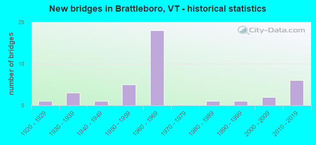
- New bridges - historical statistics
- 11920-1929
- 31930-1939
- 11940-1949
- 51950-1959
- 181960-1969
- 11980-1989
- 11990-1999
- 22000-2009
- 62010-2019

- Reconstructed bridges - Historical Statistics
- 11980-1989
- 21990-1999
- 22000-2009
- 12010-2019


- Bridge Condition - Deck
- 29.2%Very good
- 33.3%Good
- 25.0%Satisfactory
- 12.5%Fair

- Bridge Condition - Superstructure
- 33.3%Very good
- 37.5%Good
- 16.7%Satisfactory
- 8.3%Fair
- 4.2%Poor

- Bridge Condition - Substructure
- 29.2%Very good
- 33.3%Good
- 20.8%Satisfactory
- 16.7%Fair

- Bridge Condition - Channel
- 75.0%Very good
- 12.5%Good
- 12.5%Satisfactory
Find on map >> Show street view
Structure Number: 101302005113021, Location: 0.04 MI TO JCT W CL1 TH2 (Lat: 42.849986, Lng: -72.589750), Route carried "on" structure: Other road C3372, Year Built: 1994, Status: Open, Structure Length: 1.40m (4.59ft), Average Daily Traffic: 220 (year 2019), Truck Traffic: 2%, Average Future Daily Traffic: 231 (year 2029), Design Load: HS 20, Features Intersected: WHETSTONE BROOK
Minimum Vertical Clearance: 30+ m (98+ ft), Kilometerpoint: 0.000, Lanes on structure: 2, Owner: Town or Township Highway Agency, Approaching Roadway Width: 8.5m (27.9ft), Skew: 1 degrees, Material/Design: Concrete, Design/Construction: Slab, Number Of Spans In Main Unit: 1, Length of Maximum Span: 13.4m (44.0ft), Curb-To-Curb Width: 7.9m (25.9ft), Out-to-Out Width: 8.4m (27.6ft)
Condition: Deck: Very good, Superstructure: Very good, Substructure: Very good, Channel: Very good, Operating Rating: 45.4 metric tons, Method Used To Determine Operating Rating: Allowable Stress (AS), Inventory Rating: 32.7 metric tons, Method Used To Determine Inventory Rating: Allowable Stress (AS), Structural Evaluation: Equal to present desirable criteria, Deck Geometry: Somewhat better than minimum adequacy, Waterway Adequacy: Equal to present desirable criteria, Approach Roadway Alignment: Equal to present desirable criteria, Designated Inspection Frequency: Every 24 months, Inspection Date: September 2020, Deck Structure Type: Concrete Cast-file-Place, Wearing Surface/Protective System: Wearing Surface: Bituminous, Membrane: Preformed Fabric, Deck Protection: Epoxy Coated Reinforcing
Find on map >> Show street view
Structure Number: 101302B06113021, Location: AT VERMONT STATE LINE (Lat: 42.851814, Lng: -72.555436), Route carried "on" structure: State highway 119, Year Built: 1920, Year Reconstructed: 1988, Status: Open, Structure Length: 10.33m (33.89ft), Average Daily Traffic: 7,103 (year 2020), Truck Traffic: 4%, Average Future Daily Traffic: 10,512 (year 2042), Design Load: H 15, Features Intersected: CONNECTICUT RIVER
Minimum Vertical Clearance: 4.63m (15.19ft), Kilometerpoint: 0.037, Lanes on structure: 2, Owner: State Highway Agency, Approaching Roadway Width: 10.4m (34.1ft), Material/Design: Steel, Design/Construction: Truss - Thru, Number Of Spans In Main Unit: 1, Length of Maximum Span: 98.8m (324.1ft), Curb or Sidewalk Widths: Left: 1.8m (5.9ft), Right: 0.0m, Curb-To-Curb Width: 6.2m (20.3ft), Out-to-Out Width: 7.0m (23.0ft)
Condition: Deck: Good, Superstructure: Poor, Substructure: Satisfactory, Channel: Good, Operating Rating: 40.9 metric tons, Method Used To Determine Operating Rating: Load Factor (LF), Inventory Rating: 24.5 metric tons, Method Used To Determine Inventory Rating: Load Factor (LF), Structural Evaluation: Meets minimum limits, Deck Geometry: High priority of replacement, Waterway Adequacy: Equal to present desirable criteria, Approach Roadway Alignment: Meets minimum limits, Length Of Structure Improvement: 10.33m (33.89ft), Designated Inspection Frequency: Every 8 months, Critical Feature Inspection Frequency: Every 24 months, Underwater Inspection Frequency: Every 60 months, Inspection Date: November 2021, Critical Feature Inspection Date: July 2020, Underwater Inspection Date: July 2020, Bridge Improvement Cost: $2,718,000, Roadway Improvement Cost: $200,000, Total Project Cost: $3,142,000 ( Estimate for 2022), Deck Structure Type: Concrete Precast Panels
Find on map >> Show street view
Structure Number: 200010054A13022, Location: I 91 EXIT 2 (Lat: 42.850661, Lng: -72.579314), Route carried "on" structure: State highway 9, Year Built: 1960, Status: Open, Structure Length: 4.21m (13.81ft), Average Daily Traffic: 12,600 (year 2018), Truck Traffic: 7%, Average Future Daily Traffic: 13,230 (year 2028), Design Load: HS 20, Features Intersected: I 91 UNDER VT 9
Minimum Vertical Clearance: 30+ m (98+ ft), Kilometerpoint: 70.207, Lanes on structure: 4, Lanes under structure: 4, Base Highway Network: Yes, Owner: State Highway Agency, Approaching Roadway Width: 11.6m (38.1ft), Skew: 20 degrees, Material/Design: Steel, Design/Construction: Stringer/Multi-beam, Number Of Spans In Main Unit: 2, Length of Maximum Span: 20.4m (66.9ft), Curb or Sidewalk Widths: Left: 0.2m (0.7ft), Right: 1.6m (5.2ft), Curb-To-Curb Width: 22.0m (72.2ft), Out-to-Out Width: 22.9m (75.1ft)
Condition: Deck: Fair, Superstructure: Good, Substructure: Satisfactory, Operating Rating: 89.8 metric tons, Method Used To Determine Operating Rating: Load Factor (LF), Inventory Rating: 54.4 metric tons, Method Used To Determine Inventory Rating: Load Factor (LF), Structural Evaluation: Equal to present minimum criteria, Deck Geometry: Superior to present desirable criteria, Underclear: Somewhat better than minimum adequacy, Approach Roadway Alignment: Equal to present desirable criteria, Designated Inspection Frequency: Every 24 months, Inspection Date: May 2020, Deck Structure Type: Concrete Cast-file-Place, Wearing Surface/Protective System: Wearing Surface: Bituminous, Membrane: Preformed Fabric
Find on map >> Show street view
Structure Number: 200010B05613022, Location: RT9, NH/VT BORDER (Lat: 42.884183, Lng: -72.551717), Route carried "on" structure: State highway 9, Year Built: 2003, Status: Open, Structure Length: 13.62m (44.69ft), Average Daily Traffic: 9,969 (year 2020), Truck Traffic: 8%, Average Future Daily Traffic: 14,754 (year 2042), Design Load: HS 25 or greater, Features Intersected: CONNECTICUT RIVER
Minimum Vertical Clearance: 5.56m (18.24ft), Kilometerpoint: 0.029, Lanes on structure: 2, Base Highway Network: Yes, Owner: State Highway Agency, Approaching Roadway Width: 13.0m (42.7ft), Material/Design: Steel, Design/Construction: Arch - Thru, Number Of Spans In Main Unit: 1, Length of Maximum Span: 130.0m (426.5ft), Curb or Sidewalk Widths: Left: 0.1m (0.3ft), Right: 0.1m (0.3ft), Curb-To-Curb Width: 13.2m (43.3ft), Out-to-Out Width: 13.9m (45.6ft)
Condition: Deck: Good, Superstructure: Good, Substructure: Very good, Channel: Very good, Operating Rating: 73.5 metric tons, Method Used To Determine Operating Rating: Load Factor (LF), Inventory Rating: 44.1 metric tons, Method Used To Determine Inventory Rating: Load Factor (LF), Structural Evaluation: Better than present minimum criteria, Deck Geometry: Somewhat better than minimum adequacy, Waterway Adequacy: Superior to present desirable criteria, Approach Roadway Alignment: Equal to present desirable criteria, Length Of Structure Improvement: 13.62m (44.69ft), Designated Inspection Frequency: Every 24 months, Critical Feature Inspection Frequency: Every 24 months, Inspection Date: May 2020, Critical Feature Inspection Date: May 2020, Bridge Improvement Cost: $2,718,000, Roadway Improvement Cost: $200,000, Total Project Cost: $3,142,000 ( Estimate for 2022), Deck Structure Type: Concrete Cast-file-Place, Wearing Surface/Protective System: Wearing Surface: Bituminous, Membrane: Other, Deck Protection: Epoxy Coated Reinforcing
Find on map >> Show street view
Structure Number: 200091000913022, Location: 0.9 MI S EXIT 3 (Lat: 42.874628, Lng: -72.570603), Route carried "on" structure: Interstate 91, Year Built: 2017, Status: Open, Structure Length: 31.58m (103.61ft), Average Daily Traffic: 24,200 (year 2018), Truck Traffic: 10%, Average Future Daily Traffic: 25,410 (year 2028), Design Load: HL 93, Features Intersected: I 91 OVER VT 30 WESTR
Minimum Vertical Clearance: 30+ m (98+ ft), Kilometerpoint: 17.007, Lanes on structure: 2, Lanes under structure: 2, Base Highway Network: Yes, Owner: State Highway Agency, Approaching Roadway Width: 11.6m (38.1ft), Skew: 30 degrees, Material/Design: Prestressed concrete continuous, Design/Construction: Segmental Box Girder, Number Of Spans In Main Unit: 3, Length of Maximum Span: 157.0m (515.1ft), Curb-To-Curb Width: 30.8m (101.0ft), Out-to-Out Width: 31.9m (104.7ft)
Condition: Deck: Good, Superstructure: Very good, Substructure: Very good, Channel: Very good, Operating Rating: 54.4 metric tons, Method Used To Determine Operating Rating: Load Factor (LF), Inventory Rating: 32.7 metric tons, Method Used To Determine Inventory Rating: Load Factor (LF), Structural Evaluation: Equal to present desirable criteria, Deck Geometry: Superior to present desirable criteria, Underclear: Equal to present minimum criteria, Waterway Adequacy: Equal to present desirable criteria, Approach Roadway Alignment: Equal to present desirable criteria, Designated Inspection Frequency: Every 24 months, Inspection Date: May 2020, Deck Structure Type: Concrete Precast Panels, Wearing Surface/Protective System: Deck Protection: Other
Find on map >> Show street view
Structure Number: 200091004N13022, Location: I 91 EXIT 1 (Lat: 42.835547, Lng: -72.566639), Route carried "on" structure: Interstate 91, Year Built: 1959, Status: Open, Structure Length: 6.04m (19.82ft), Average Daily Traffic: 18,300 (year 2018), Truck Traffic: 13%, Average Future Daily Traffic: 19,215 (year 2028), Design Load: HS 20, Features Intersected: I 91 OVER US 5
Minimum Vertical Clearance: 30+ m (98+ ft), Kilometerpoint: 12.035, Lanes on structure: 2, Lanes under structure: 2, Base Highway Network: Yes, Owner: State Highway Agency, Approaching Roadway Width: 11.6m (38.1ft), Skew: 14 degrees, Material/Design: Steel, Design/Construction: Stringer/Multi-beam, Number Of Spans In Main Unit: 2, Length of Maximum Span: 29.3m (96.1ft), Curb or Sidewalk Widths: Left: 0.2m (0.7ft), Right: 0.2m (0.7ft), Curb-To-Curb Width: 9.1m (29.9ft), Out-to-Out Width: 10.7m (35.1ft)
Condition: Deck: Fair, Superstructure: Good, Substructure: Satisfactory, Operating Rating: 89.8 metric tons, Method Used To Determine Operating Rating: Load Factor (LF), Inventory Rating: 59.0 metric tons, Method Used To Determine Inventory Rating: Load Factor (LF), Structural Evaluation: Equal to present minimum criteria, Deck Geometry: Meets minimum limits, Underclear: High priority of corrective action, Approach Roadway Alignment: Equal to present desirable criteria, Length Of Structure Improvement: 6.04m (19.82ft), Designated Inspection Frequency: Every 24 months, Inspection Date: May 2020, Bridge Improvement Cost: $2,432,000, Roadway Improvement Cost: $50,000, Total Project Cost: $2,482,000 ( Estimate for 2020), Deck Structure Type: Concrete Cast-file-Place, Wearing Surface/Protective System: Wearing Surface: Bituminous, Membrane: Preformed Fabric
Find on map >> Show street view
Structure Number: 200091004S13022, Location: I 91 EXIT 1 (Lat: 42.835289, Lng: -72.566775), Route carried "on" structure: Interstate 91, Year Built: 1959, Status: Open, Structure Length: 6.04m (19.82ft), Average Daily Traffic: 18,300 (year 2018), Truck Traffic: 13%, Average Future Daily Traffic: 19,215 (year 2028), Design Load: HS 20, Features Intersected: I 91 OVER US 5
Minimum Vertical Clearance: 30+ m (98+ ft), Kilometerpoint: 12.035, Lanes on structure: 3, Lanes under structure: 2, Base Highway Network: Yes, Owner: State Highway Agency, Approaching Roadway Width: 11.6m (38.1ft), Skew: 14 degrees, Material/Design: Steel, Design/Construction: Stringer/Multi-beam, Number Of Spans In Main Unit: 2, Length of Maximum Span: 29.3m (96.1ft), Curb or Sidewalk Widths: Left: 0.2m (0.7ft), Right: 0.2m (0.7ft), Curb-To-Curb Width: 13.4m (44.0ft), Out-to-Out Width: 15.0m (49.2ft)
Condition: Deck: Fair, Superstructure: Good, Substructure: Fair, Operating Rating: 89.8 metric tons, Method Used To Determine Operating Rating: Load Factor (LF), Inventory Rating: 60.8 metric tons, Method Used To Determine Inventory Rating: Load Factor (LF), Structural Evaluation: Somewhat better than minimum adequacy, Deck Geometry: Meets minimum limits, Underclear: Meets minimum limits, Approach Roadway Alignment: Equal to present desirable criteria, Length Of Structure Improvement: 6.04m (19.82ft), Designated Inspection Frequency: Every 24 months, Inspection Date: May 2020, Bridge Improvement Cost: $3,410,000, Roadway Improvement Cost: $50,000, Total Project Cost: $3,460,000 ( Estimate for 2020), Deck Structure Type: Concrete Cast-file-Place, Wearing Surface/Protective System: Wearing Surface: Bituminous, Membrane: Preformed Fabric
Find on map >> Show street view
Structure Number: 200091005N13022, Location: 0.7 MI N EXIT 1 (Lat: 42.844544, Lng: -72.572992), Route carried "on" structure: Interstate 91, Year Built: 1960, Year Reconstructed: 2011, Status: Open, Structure Length: 4.33m (14.21ft), Average Daily Traffic: 19,400 (year 2018), Truck Traffic: 8%, Average Future Daily Traffic: 20,370 (year 2028), Design Load: HL 93, Features Intersected: I 91 NB OVER MAPLE ST
Minimum Vertical Clearance: 30+ m (98+ ft), Kilometerpoint: 13.178, Lanes on structure: 2, Lanes under structure: 2, Base Highway Network: Yes, Owner: State Highway Agency, Approaching Roadway Width: 11.6m (38.1ft), Skew: 11 degrees, Material/Design: Prestressed concrete continuous, Design/Construction: Tee Beam, Number Of Spans In Main Unit: 3, Length of Maximum Span: 14.3m (46.9ft), Curb or Sidewalk Widths: Left: 0.2m (0.7ft), Right: 0.2m (0.7ft), Curb-To-Curb Width: 12.8m (42.0ft), Out-to-Out Width: 14.4m (47.2ft)
Condition: Deck: Very good, Superstructure: Very good, Substructure: Good, Operating Rating: 73.5 metric tons, Method Used To Determine Operating Rating: Load and Resistance Factor (LRFR), Inventory Rating: 49.9 metric tons, Method Used To Determine Inventory Rating: Load and Resistance Factor (LRFR), Structural Evaluation: Better than present minimum criteria, Deck Geometry: Equal to present desirable criteria, Underclear: Somewhat better than minimum adequacy, Approach Roadway Alignment: Equal to present desirable criteria, Designated Inspection Frequency: Every 24 months, Inspection Date: May 2020, Deck Structure Type: Concrete Cast-file-Place, Wearing Surface/Protective System: Wearing Surface: Bituminous
Find on map >> Show street view
Structure Number: 200091005S13022, Location: 0.7 MI N EXIT 1 (Lat: 42.844506, Lng: -72.573297), Route carried "on" structure: Interstate 91, Year Built: 1960, Year Reconstructed: 2012, Status: Open, Structure Length: 3.87m (12.70ft), Average Daily Traffic: 19,400 (year 2018), Truck Traffic: 8%, Average Future Daily Traffic: 20,370 (year 2028), Design Load: HL 93, Features Intersected: I 91 SB OVER MAPLE ST
Minimum Vertical Clearance: 30+ m (98+ ft), Kilometerpoint: 13.178, Lanes on structure: 2, Lanes under structure: 2, Base Highway Network: Yes, Owner: State Highway Agency, Approaching Roadway Width: 11.6m (38.1ft), Skew: 12 degrees, Material/Design: Prestressed concrete continuous, Design/Construction: Tee Beam, Number Of Spans In Main Unit: 3, Length of Maximum Span: 14.3m (46.9ft), Curb or Sidewalk Widths: Left: 0.2m (0.7ft), Right: 0.2m (0.7ft), Curb-To-Curb Width: 12.8m (42.0ft), Out-to-Out Width: 14.4m (47.2ft)
Condition: Deck: Very good, Superstructure: Good, Substructure: Good, Operating Rating: 73.5 metric tons, Method Used To Determine Operating Rating: Load and Resistance Factor (LRFR), Inventory Rating: 49.9 metric tons, Method Used To Determine Inventory Rating: Load and Resistance Factor (LRFR), Structural Evaluation: Better than present minimum criteria, Deck Geometry: Equal to present desirable criteria, Underclear: Somewhat better than minimum adequacy, Approach Roadway Alignment: Equal to present desirable criteria, Designated Inspection Frequency: Every 24 months, Inspection Date: May 2020, Deck Structure Type: Concrete Cast-file-Place
Find on map >> Show street view
Structure Number: 200091006N13022, Location: 0.2 MI S EXIT 2 (Lat: 42.848856, Lng: -72.578375), Route carried "on" structure: Interstate 91, Year Built: 2012, Status: Open, Structure Length: 11.83m (38.81ft), Average Daily Traffic: 19,400 (year 2018), Truck Traffic: 8%, Average Future Daily Traffic: 20,370 (year 2028), Design Load: HL 93, Features Intersected: I 91 OVER WILLIAMS ST
Minimum Vertical Clearance: 30+ m (98+ ft), Kilometerpoint: 13.821, Lanes on structure: 2, Lanes under structure: 2, Base Highway Network: Yes, Owner: State Highway Agency, Approaching Roadway Width: 11.3m (37.1ft), Skew: 11 degrees, Material/Design: Steel, Design/Construction: Stringer/Multi-beam, Number Of Spans In Main Unit: 2, Length of Maximum Span: 73.2m (240.2ft), Curb-To-Curb Width: 11.6m (38.1ft), Out-to-Out Width: 12.5m (41.0ft)
Condition: Deck: Good, Superstructure: Very good, Substructure: Very good, Channel: Very good, Operating Rating: 54.4 metric tons, Method Used To Determine Operating Rating: Load and Resistance Factor (LRFR), Inventory Rating: 41.7 metric tons, Method Used To Determine Inventory Rating: Load and Resistance Factor (LRFR), Structural Evaluation: Equal to present desirable criteria, Deck Geometry: Equal to present minimum criteria, Underclear: Meets minimum limits, Waterway Adequacy: Equal to present desirable criteria, Approach Roadway Alignment: Equal to present desirable criteria, Designated Inspection Frequency: Every 24 months, Inspection Date: May 2020, Deck Structure Type: Concrete Cast-file-Place, Wearing Surface/Protective System: Wearing Surface: Monolithic Concrete, Deck Protection: Epoxy Coated Reinforcing
Find on map >> Show street view
Structure Number: 200091006S13022, Location: 0.2 MI S EXIT 2 (Lat: 42.848775, Lng: -72.578636), Route carried "on" structure: Interstate 91, Year Built: 2012, Status: Open, Structure Length: 11.83m (38.81ft), Average Daily Traffic: 19,400 (year 2018), Truck Traffic: 8%, Average Future Daily Traffic: 20,370 (year 2028), Design Load: HL 93, Features Intersected: I 91 OVER WILLIAMS ST
Minimum Vertical Clearance: 30+ m (98+ ft), Kilometerpoint: 13.821, Lanes on structure: 2, Lanes under structure: 2, Base Highway Network: Yes, Owner: State Highway Agency, Approaching Roadway Width: 11.3m (37.1ft), Skew: 10 degrees, Material/Design: Steel, Design/Construction: Stringer/Multi-beam, Number Of Spans In Main Unit: 2, Length of Maximum Span: 73.2m (240.2ft), Curb-To-Curb Width: 11.6m (38.1ft), Out-to-Out Width: 12.5m (41.0ft)
Condition: Deck: Good, Superstructure: Very good, Substructure: Very good, Channel: Very good, Operating Rating: 54.4 metric tons, Method Used To Determine Operating Rating: Load and Resistance Factor (LRFR), Inventory Rating: 41.7 metric tons, Method Used To Determine Inventory Rating: Load and Resistance Factor (LRFR), Structural Evaluation: Equal to present desirable criteria, Deck Geometry: Equal to present minimum criteria, Underclear: Meets minimum limits, Waterway Adequacy: Equal to present desirable criteria, Approach Roadway Alignment: Equal to present desirable criteria, Designated Inspection Frequency: Every 24 months, Inspection Date: May 2020, Deck Structure Type: Concrete Cast-file-Place, Wearing Surface/Protective System: Wearing Surface: Monolithic Concrete, Deck Protection: Epoxy Coated Reinforcing
Find on map >> Show street view
Structure Number: 200091011N13022, Location: I 91 EXIT 3 (Lat: 42.885869, Lng: -72.558878), Route carried "on" structure: Interstate 91, Year Built: 1960, Status: Open, Structure Length: 4.33m (14.21ft), Average Daily Traffic: 16,600 (year 2018), Truck Traffic: 13%, Average Future Daily Traffic: 17,430 (year 2028), Design Load: HS 20, Features Intersected: I 91 OVER BRATT.SH
Minimum Vertical Clearance: 30+ m (98+ ft), Kilometerpoint: 18.584, Lanes on structure: 2, Lanes under structure: 2, Base Highway Network: Yes, Owner: State Highway Agency, Approaching Roadway Width: 11.6m (38.1ft), Skew: 10 degrees, Material/Design: Steel, Design/Construction: Stringer/Multi-beam, Number Of Spans In Main Unit: 3, Length of Maximum Span: 18.9m (62.0ft), Curb or Sidewalk Widths: Left: 0.2m (0.7ft), Right: 0.2m (0.7ft), Curb-To-Curb Width: 12.8m (42.0ft), Out-to-Out Width: 14.3m (46.9ft)
Condition: Deck: Good, Superstructure: Satisfactory, Substructure: Fair, Operating Rating: 89.8 metric tons, Method Used To Determine Operating Rating: Load Factor (LF), Inventory Rating: 55.3 metric tons, Method Used To Determine Inventory Rating: Load Factor (LF), Structural Evaluation: Somewhat better than minimum adequacy, Deck Geometry: Equal to present desirable criteria, Underclear: Meets minimum limits, Approach Roadway Alignment: Equal to present desirable criteria, Designated Inspection Frequency: Every 24 months, Inspection Date: May 2020, Deck Structure Type: Concrete Cast-file-Place, Wearing Surface/Protective System: Wearing Surface: Bituminous, Membrane: Preformed Fabric
Find on map >> Show street view
Structure Number: 200091011S13022, Location: I 91 EXIT 3 (Lat: 42.885989, Lng: -72.559144), Route carried "on" structure: Interstate 91, Year Built: 1960, Status: Open, Structure Length: 4.33m (14.21ft), Average Daily Traffic: 16,600 (year 2018), Truck Traffic: 13%, Average Future Daily Traffic: 17,430 (year 2028), Design Load: HS 20, Features Intersected: I 91 OVER BRATT.SH
Minimum Vertical Clearance: 30+ m (98+ ft), Kilometerpoint: 18.584, Lanes on structure: 3, Lanes under structure: 2, Base Highway Network: Yes, Owner: State Highway Agency, Approaching Roadway Width: 11.6m (38.1ft), Skew: 10 degrees, Material/Design: Steel, Design/Construction: Stringer/Multi-beam, Number Of Spans In Main Unit: 3, Length of Maximum Span: 18.9m (62.0ft), Curb or Sidewalk Widths: Left: 0.2m (0.7ft), Right: 0.2m (0.7ft), Curb-To-Curb Width: 12.8m (42.0ft), Out-to-Out Width: 14.3m (46.9ft)
Condition: Deck: Satisfactory, Superstructure: Satisfactory, Substructure: Fair, Operating Rating: 88.0 metric tons, Method Used To Determine Operating Rating: Load Factor (LF), Inventory Rating: 52.6 metric tons, Method Used To Determine Inventory Rating: Load Factor (LF), Structural Evaluation: Somewhat better than minimum adequacy, Deck Geometry: High priority of replacement, Underclear: Meets minimum limits, Approach Roadway Alignment: Equal to present desirable criteria, Length Of Structure Improvement: 4.33m (14.21ft), Designated Inspection Frequency: Every 24 months, Inspection Date: May 2020, Bridge Improvement Cost: $2,336,000, Roadway Improvement Cost: $50,000, Total Project Cost: $2,386,000 ( Estimate for 2020), Deck Structure Type: Concrete Cast-file-Place, Wearing Surface/Protective System: Wearing Surface: Bituminous, Membrane: Preformed Fabric
Find on map >> Show street view
Structure Number: 20009111-213022, Location: 0.3 MI N EXIT 3 (Lat: 42.889689, Lng: -72.555922), Route carried "on" structure: Interstate 91, Year Built: 1961, Status: Open, Structure Length: 0.61m (2.00ft), Average Daily Traffic: 16,600 (year 2018), Truck Traffic: 13%, Average Future Daily Traffic: 17,430 (year 2028), Design Load: H 20, Features Intersected: BROOK
Minimum Vertical Clearance: 30+ m (98+ ft), Kilometerpoint: 19.083, Lanes on structure: 2, Base Highway Network: Yes, Owner: State Highway Agency, Approaching Roadway Width: 23.2m (76.1ft), Skew: 13 degrees, Material/Design: Concrete, Design/Construction: Culvert, Number Of Spans In Main Unit: 1, Length of Maximum Span: 6.1m (20.0ft)
Condition: Channel: Satisfactory, Culverts: Good, Operating Rating: 37.2 metric tons, Method Used To Determine Operating Rating: Field evaluation and documented engineering judgment, Inventory Rating: 22.7 metric tons, Method Used To Determine Inventory Rating: Field evaluation and documented engineering judgment, Structural Evaluation: Somewhat better than minimum adequacy, Waterway Adequacy: Equal to present minimum criteria, Approach Roadway Alignment: Equal to present desirable criteria, Designated Inspection Frequency: Every 24 months, Inspection Date: May 2020
Find on map >> Show street view
Structure Number: 200113010B13022, Location: 0.6 MI N JCT. VT.9 E (Lat: 42.893706, Lng: -72.551147), Route carried "on" structure: US 5, Year Built: 1961, Status: Open, Structure Length: 8.69m (28.51ft), Average Daily Traffic: 8,200 (year 2018), Truck Traffic: 6%, Average Future Daily Traffic: 8,610 (year 2028), Design Load: HS 20, Features Intersected: I 91 UNDER US 5
Minimum Vertical Clearance: 30+ m (98+ ft), Kilometerpoint: 0.000, Lanes on structure: 2, Lanes under structure: 4, Base Highway Network: Yes, Owner: State Highway Agency, Approaching Roadway Width: 12.2m (40.0ft), Skew: 3 degrees, Material/Design: Steel, Design/Construction: Stringer/Multi-beam, Number Of Spans In Main Unit: 4, Length of Maximum Span: 24.1m (79.1ft), Curb or Sidewalk Widths: Left: 0.2m (0.7ft), Right: 0.2m (0.7ft), Curb-To-Curb Width: 9.1m (29.9ft), Out-to-Out Width: 10.7m (35.1ft)
Condition: Deck: Satisfactory, Superstructure: Good, Substructure: Fair, Operating Rating: 85.3 metric tons, Method Used To Determine Operating Rating: Load Factor (LF), Inventory Rating: 50.8 metric tons, Method Used To Determine Inventory Rating: Load Factor (LF), Structural Evaluation: Somewhat better than minimum adequacy, Deck Geometry: Meets minimum limits, Underclear: Somewhat better than minimum adequacy, Approach Roadway Alignment: Equal to present desirable criteria, Length Of Structure Improvement: 8.69m (28.51ft), Designated Inspection Frequency: Every 24 months, Inspection Date: May 2020, Bridge Improvement Cost: $3,491,000, Roadway Improvement Cost: $50,000, Total Project Cost: $3,541,000 ( Estimate for 2020), Deck Structure Type: Concrete Cast-file-Place, Wearing Surface/Protective System: Wearing Surface: Bituminous, Membrane: Preformed Fabric
Find on map >> Show street view
Structure Number: 2013020D1013021, Location: 0.2 MI S EXIT 3 (Lat: 42.882261, Lng: -72.562258), Route carried "on" structure: County highway TH36, Year Built: 1960, Status: Open, Structure Length: 6.89m (22.60ft), Average Daily Traffic: 600 (year 2019), Truck Traffic: 2%, Average Future Daily Traffic: 630 (year 2029), Design Load: HS 20+Mod, Features Intersected: TH NO 36 OVER I 91
Minimum Vertical Clearance: 30+ m (98+ ft), Kilometerpoint: 0.000, Lanes on structure: 2, Lanes under structure: 4, Owner: State Highway Agency, Approaching Roadway Width: 9.1m (29.9ft), Material/Design: Steel, Design/Construction: Stringer/Multi-beam, Number Of Spans In Main Unit: 4, Length of Maximum Span: 23.5m (77.1ft), Curb or Sidewalk Widths: Left: 0.5m (1.6ft), Right: 0.5m (1.6ft), Curb-To-Curb Width: 9.1m (29.9ft), Out-to-Out Width: 10.7m (35.1ft)
Condition: Deck: Satisfactory, Superstructure: Fair, Substructure: Satisfactory, Operating Rating: 88.9 metric tons, Method Used To Determine Operating Rating: Load Factor (LF), Inventory Rating: 52.6 metric tons, Method Used To Determine Inventory Rating: Load Factor (LF), Structural Evaluation: Somewhat better than minimum adequacy, Deck Geometry: Equal to present minimum criteria, Underclear: Better than present minimum criteria, Approach Roadway Alignment: Equal to present desirable criteria, Designated Inspection Frequency: Every 24 months, Inspection Date: May 2020, Deck Structure Type: Concrete Cast-file-Place, Wearing Surface/Protective System: Wearing Surface: Bituminous
Find on map >> Show street view
Structure Number: 202000000713022, Location: 0.1 MI N JCT. VT.142 (Lat: 42.850928, Lng: -72.557533), Route carried "on" structure: US 5, Year Built: 1938, Year Reconstructed: 2003, Status: Open, Structure Length: 2.04m (6.69ft), Average Daily Traffic: 17,500 (year 2018), Truck Traffic: 2%, Average Future Daily Traffic: 18,375 (year 2028), Design Load: HS 25 or greater, Features Intersected: WHETSTONE BROOK
Minimum Vertical Clearance: 30+ m (98+ ft), Kilometerpoint: 0.000, Lanes on structure: 3, Base Highway Network: Yes, Owner: City or Municipal Highway Agency, Approaching Roadway Width: 14.6m (47.9ft), Material/Design: Steel, Design/Construction: Stringer/Multi-beam, Number Of Spans In Main Unit: 1, Length of Maximum Span: 18.6m (61.0ft), Curb or Sidewalk Widths: Left: 1.6m (5.2ft), Right: 1.6m (5.2ft), Curb-To-Curb Width: 17.9m (58.7ft), Out-to-Out Width: 23.5m (77.1ft)
Condition: Deck: Very good, Superstructure: Very good, Substructure: Good, Channel: Very good, Operating Rating: 70.8 metric tons, Method Used To Determine Operating Rating: Load Factor (LF), Inventory Rating: 42.6 metric tons, Method Used To Determine Inventory Rating: Load Factor (LF), Structural Evaluation: Better than present minimum criteria, Deck Geometry: Superior to present desirable criteria, Waterway Adequacy: Equal to present desirable criteria, Approach Roadway Alignment: Equal to present desirable criteria, Designated Inspection Frequency: Every 24 months, Inspection Date: May 2021, Deck Structure Type: Concrete Cast-file-Place, Wearing Surface/Protective System: Wearing Surface: Bituminous, Membrane: Preformed Fabric, Deck Protection: Epoxy Coated Reinforcing
Find on map >> Show street view
Structure Number: 202000000813022, Location: 0.9 MI N JCT. VT.9 W (Lat: 42.866511, Lng: -72.556356), Route carried "on" structure: US 5, Year Built: 1987, Status: Open, Structure Length: 10.85m (35.60ft), Average Daily Traffic: 14,600 (year 2018), Truck Traffic: 11%, Average Future Daily Traffic: 15,330 (year 2028), Design Load: HS 20+Mod, Features Intersected: WEST RIVER
Minimum Vertical Clearance: 30+ m (98+ ft), Kilometerpoint: 0.000, Lanes on structure: 2, Base Highway Network: Yes, Owner: State Highway Agency, Approaching Roadway Width: 12.2m (40.0ft), Material/Design: Steel continuous, Design/Construction: Stringer/Multi-beam, Number Of Spans In Main Unit: 2, Length of Maximum Span: 53.6m (175.9ft), Curb or Sidewalk Widths: Left: 1.7m (5.6ft), Right: 0.2m (0.7ft), Curb-To-Curb Width: 12.0m (39.4ft), Out-to-Out Width: 14.7m (48.2ft)
Condition: Deck: Very good, Superstructure: Very good, Substructure: Good, Channel: Very good, Operating Rating: 89.8 metric tons, Method Used To Determine Operating Rating: Allowable Stress (AS), Inventory Rating: 44.5 metric tons, Method Used To Determine Inventory Rating: Allowable Stress (AS), Structural Evaluation: Better than present minimum criteria, Deck Geometry: Somewhat better than minimum adequacy, Waterway Adequacy: Equal to present desirable criteria, Approach Roadway Alignment: Equal to present desirable criteria, Designated Inspection Frequency: Every 24 months, Underwater Inspection Frequency: Every 48 months, Inspection Date: May 2021, Underwater Inspection Date: August 2019, Deck Structure Type: Concrete Cast-file-Place, Wearing Surface/Protective System: Wearing Surface: Bituminous, Membrane: Preformed Fabric
Find on map >> Show street view
Structure Number: 202000001013022, Location: 0.1 MI S JCT. VT.9 E (Lat: 42.884428, Lng: -72.557131), Route carried "on" structure: US 5, Year Built: 1959, Status: Open, Structure Length: 1.04m (3.41ft), Average Daily Traffic: 14,600 (year 2018), Truck Traffic: 11%, Average Future Daily Traffic: 15,330 (year 2028), Design Load: HS 20, Features Intersected: BROOK
Minimum Vertical Clearance: 30+ m (98+ ft), Kilometerpoint: 0.000, Lanes on structure: 4, Base Highway Network: Yes, Owner: State Highway Agency, Approaching Roadway Width: 19.5m (64.0ft), Skew: 21 degrees, Material/Design: Steel, Design/Construction: Stringer/Multi-beam, Number Of Spans In Main Unit: 1, Length of Maximum Span: 9.8m (32.2ft), Curb or Sidewalk Widths: Left: 1.8m (5.9ft), Right: 1.8m (5.9ft), Curb-To-Curb Width: 19.5m (64.0ft), Out-to-Out Width: 23.7m (77.8ft)
Condition: Deck: Satisfactory, Superstructure: Good, Substructure: Very good, Channel: Very good, Operating Rating: 89.8 metric tons, Method Used To Determine Operating Rating: Load Factor (LF), Inventory Rating: 55.3 metric tons, Method Used To Determine Inventory Rating: Load Factor (LF), Structural Evaluation: Better than present minimum criteria, Deck Geometry: Better than present minimum criteria, Waterway Adequacy: Better than present minimum criteria, Approach Roadway Alignment: Equal to present desirable criteria, Designated Inspection Frequency: Every 24 months, Inspection Date: May 2021, Deck Structure Type: Concrete Cast-file-Place, Wearing Surface/Protective System: Wearing Surface: Bituminous, Membrane: Preformed Fabric
Find on map >> Show street view
Structure Number: 202012003113022, Location: ELLIOT ST (Lat: 42.849731, Lng: -72.567833), Route carried "on" structure: City street ELLT, Year Built: 1946, Year Reconstructed: 2016, Status: Open, Structure Length: 2.74m (8.99ft), Average Daily Traffic: 4,800 (year 2015), Truck Traffic: 1%, Average Future Daily Traffic: 5,040 (year 2025), Design Load: HL 93, Features Intersected: WHETSTONE BROOK, Facility Carried by Structure: CITY ELLIOT
Minimum Vertical Clearance: 30+ m (98+ ft), Kilometerpoint: 0.000, Lanes on structure: 2, Owner: City or Municipal Highway Agency, Approaching Roadway Width: 7.3m (24.0ft), Material/Design: Steel, Design/Construction: Stringer/Multi-beam, Number Of Spans In Main Unit: 1, Length of Maximum Span: 26.8m (87.9ft), Curb or Sidewalk Widths: Left: 0.0m, Right: 1.5m (4.9ft), Curb-To-Curb Width: 8.4m (27.6ft), Out-to-Out Width: 9.1m (29.9ft)
Condition: Deck: Good, Superstructure: Good, Substructure: Good, Channel: Very good, Operating Rating: 42.6 metric tons, Method Used To Determine Operating Rating: Load and Resistance Factor (LRFR), Inventory Rating: 32.7 metric tons, Method Used To Determine Inventory Rating: Load and Resistance Factor (LRFR), Structural Evaluation: Better than present minimum criteria, Deck Geometry: High priority of corrective action, Waterway Adequacy: Equal to present desirable criteria, Approach Roadway Alignment: Meets minimum limits, Length Of Structure Improvement: 2.74m (8.99ft), Designated Inspection Frequency: Every 24 months, Inspection Date: June 2020, Bridge Improvement Cost: $942,000, Roadway Improvement Cost: $50,000, Total Project Cost: $992,000 ( Estimate for 2020), Deck Structure Type: Concrete Cast-file-Place, Wearing Surface/Protective System: Deck Protection: Epoxy Coated Reinforcing
Find on map >> Show street view
Structure Number: 202014003213022, Location: ELM ST (Lat: 42.849047, Lng: -72.560958), Route carried "on" structure: City street ELM, Year Built: 1966, Status: Open, Structure Length: 2.71m (8.89ft), Average Daily Traffic: 3,600 (year 2016), Truck Traffic: 11%, Average Future Daily Traffic: 3,780 (year 2026), Design Load: HS 20, Features Intersected: WHETSTONE BROOK
Minimum Vertical Clearance: 30+ m (98+ ft), Kilometerpoint: 0.000, Lanes on structure: 2, Owner: City or Municipal Highway Agency, Approaching Roadway Width: 7.9m (25.9ft), Material/Design: Prestressed concrete, Design/Construction: Box Beam or Girders - Multiple, Number Of Spans In Main Unit: 1, Length of Maximum Span: 25.9m (85.0ft), Curb or Sidewalk Widths: Left: 0.5m (1.6ft), Right: 1.4m (4.6ft), Curb-To-Curb Width: 9.3m (30.5ft), Out-to-Out Width: 10.1m (33.1ft)
Condition: Deck: Good, Superstructure: Good, Substructure: Good, Channel: Very good, Operating Rating: 87.1 metric tons, Method Used To Determine Operating Rating: Load Factor (LF), Inventory Rating: 43.5 metric tons, Method Used To Determine Inventory Rating: Load Factor (LF), Structural Evaluation: Better than present minimum criteria, Deck Geometry: Meets minimum limits, Waterway Adequacy: Equal to present desirable criteria, Approach Roadway Alignment: Better than present minimum criteria, Designated Inspection Frequency: Every 24 months, Inspection Date: June 2020, Deck Structure Type: Concrete Cast-file-Place, Wearing Surface/Protective System: Wearing Surface: Bituminous, Membrane: Epoxy
Find on map >> Show street view
Structure Number: 202028003013022, Location: GUILFORD ST (Lat: 42.849533, Lng: -72.585417), Route carried "on" structure: City street GUILF, Year Built: 2010, Status: Open, Structure Length: 2.80m (9.19ft), Average Daily Traffic: 3,800 (year 2016), Truck Traffic: 4%, Average Future Daily Traffic: 3,990 (year 2026), Design Load: HS 25 or greater, Features Intersected: WHETSTONE BROOK
Minimum Vertical Clearance: 30+ m (98+ ft), Kilometerpoint: 0.000, Lanes on structure: 2, Owner: City or Municipal Highway Agency, Approaching Roadway Width: 6.1m (20.0ft), Material/Design: Steel, Design/Construction: Stringer/Multi-beam, Number Of Spans In Main Unit: 1, Length of Maximum Span: 27.4m (89.9ft), Curb or Sidewalk Widths: Left: 1.6m (5.2ft), Right: 1.6m (5.2ft), Curb-To-Curb Width: 7.8m (25.6ft), Out-to-Out Width: 11.1m (36.4ft)
Condition: Deck: Very good, Superstructure: Very good, Substructure: Very good, Channel: Very good, Operating Rating: 71.7 metric tons, Method Used To Determine Operating Rating: Load Factor (LF), Inventory Rating: 42.6 metric tons, Method Used To Determine Inventory Rating: Load Factor (LF), Structural Evaluation: Equal to present desirable criteria, Deck Geometry: High priority of replacement, Waterway Adequacy: Equal to present desirable criteria, Approach Roadway Alignment: Equal to present minimum criteria, Length Of Structure Improvement: 2.80m (9.19ft), Designated Inspection Frequency: Every 24 months, Inspection Date: June 2020, Bridge Improvement Cost: $1,172,000, Roadway Improvement Cost: $50,000, Total Project Cost: $1,222,000 ( Estimate for 2020), Deck Structure Type: Concrete Cast-file-Place, Wearing Surface/Protective System: Wearing Surface: Bituminous, Membrane: Preformed Fabric, Deck Protection: Epoxy Coated Reinforcing
Find on map >> Show street view
Structure Number: 202048003413022, Location: WILLIAMS STREET (Lat: 42.848822, Lng: -72.575000), Route carried "on" structure: City street WILMS, Year Built: 1939, Year Reconstructed: 2004, Status: Open, Structure Length: 3.02m (9.91ft), Average Daily Traffic: 910 (year 2016), Truck Traffic: 4%, Average Future Daily Traffic: 956 (year 2026), Design Load: HS 20, Features Intersected: WHETSTONE BROOK
Minimum Vertical Clearance: 30+ m (98+ ft), Kilometerpoint: 0.000, Lanes on structure: 2, Owner: City or Municipal Highway Agency, Approaching Roadway Width: 6.7m (22.0ft), Skew: 1 degrees, Material/Design: Steel, Design/Construction: Stringer/Multi-beam, Number Of Spans In Main Unit: 1, Length of Maximum Span: 29.6m (97.1ft), Curb or Sidewalk Widths: Left: 0.4m (1.3ft), Right: 0.4m (1.3ft), Curb-To-Curb Width: 6.7m (22.0ft), Out-to-Out Width: 7.5m (24.6ft)
Condition: Deck: Very good, Superstructure: Satisfactory, Substructure: Good, Channel: Very good, Operating Rating: 66.2 metric tons, Method Used To Determine Operating Rating: Load Factor (LF), Inventory Rating: 39.9 metric tons, Method Used To Determine Inventory Rating: Load Factor (LF), Structural Evaluation: Equal to present minimum criteria, Deck Geometry: Meets minimum limits, Waterway Adequacy: Equal to present desirable criteria, Approach Roadway Alignment: Equal to present desirable criteria, Designated Inspection Frequency: Every 24 months, Inspection Date: June 2020, Deck Structure Type: Concrete Cast-file-Place, Wearing Surface/Protective System: Wearing Surface: Bituminous, Membrane: Preformed Fabric, Deck Protection: Epoxy Coated Reinforcing
Find on map >> Show street view
Structure Number: 202048003513022, Location: WILLIAMS STREET (Lat: 42.848708, Lng: -72.573094), Route carried "on" structure: City street WILMS, Year Built: 1930, Status: Open, Structure Length: 3.29m (10.79ft), Average Daily Traffic: 910 (year 2016), Truck Traffic: 3%, Average Future Daily Traffic: 956 (year 2026), Features Intersected: WHETSTONE BROOK
Minimum Vertical Clearance: 30+ m (98+ ft), Kilometerpoint: 0.000, Lanes on structure: 2, Owner: City or Municipal Highway Agency, Approaching Roadway Width: 7.3m (24.0ft), Skew: 3 degrees, Material/Design: Steel, Design/Construction: Stringer/Multi-beam, Number Of Spans In Main Unit: 2, Length of Maximum Span: 15.8m (51.8ft), Curb-To-Curb Width: 6.1m (20.0ft), Out-to-Out Width: 7.3m (24.0ft)
Condition: Deck: Satisfactory, Superstructure: Satisfactory, Substructure: Satisfactory, Channel: Satisfactory, Operating Rating: 39.0 metric tons, Method Used To Determine Operating Rating: Load Factor (LF), Inventory Rating: 22.7 metric tons, Method Used To Determine Inventory Rating: Load Factor (LF), Structural Evaluation: Equal to present minimum criteria, Deck Geometry: High priority of corrective action, Waterway Adequacy: Equal to present desirable criteria, Approach Roadway Alignment: Equal to present minimum criteria, Length Of Structure Improvement: 3.29m (10.79ft), Designated Inspection Frequency: Every 24 months, Inspection Date: June 2020, Bridge Improvement Cost: $907,000, Roadway Improvement Cost: $50,000, Total Project Cost: $957,000 ( Estimate for 2020), Deck Structure Type: Concrete Cast-file-Place, Wearing Surface/Protective System: Wearing Surface: Bituminous, Membrane: Preformed Fabric
Find on map >> Show street view
Structure Number: CEPNEDVT5010002, Location: 27.4 KM N OF BRATTLEBORO (Lat: 43.053500, Lng: -72.700942), Route carried "on" structure: ServiceFederal lands road , Year Built: 1961, Status: Open, Structure Length: 4.87m (15.98ft), Average Daily Traffic: 200 (year 2020), Truck Traffic: 10%, Average Future Daily Traffic: 250 (year 2040), Design Load: H 15, Features Intersected: SPILLWAY CHANNEL, Facility Carried by Structure: ACCESS RD
Minimum Vertical Clearance: 30+ m (98+ ft), Kilometerpoint: 0.000, Lanes on structure: 1, Owner: Corps of Engineers (Civil), Approaching Roadway Width: 4.7m (15.4ft), Material/Design: Steel, Design/Construction: Truss - Deck, Number Of Spans In Main Unit: 1, Length of Maximum Span: 48.7m (159.8ft), Curb or Sidewalk Widths: Left: 0.4m (1.3ft), Right: 0.4m (1.3ft), Curb-To-Curb Width: 3.8m (12.5ft), Out-to-Out Width: 4.7m (15.4ft)
Condition: Deck: Satisfactory, Superstructure: Fair, Substructure: Good, Channel: Good, Operating Rating: 42.8 metric tons, Method Used To Determine Operating Rating: Allowable Stress (AS), Inventory Rating: 31.1 metric tons, Method Used To Determine Inventory Rating: Allowable Stress (AS), Structural Evaluation: Somewhat better than minimum adequacy, Deck Geometry: High priority of replacement, Waterway Adequacy: Superior to present desirable criteria, Approach Roadway Alignment: High priority of corrective action, Length Of Structure Improvement: 9.16m (30.05ft), Designated Inspection Frequency: Every 24 months, Critical Feature Inspection Frequency: Every 24 months, Inspection Date: September 2020, Critical Feature Inspection Date: September 2020, Bridge Improvement Cost: $1,000,000, Roadway Improvement Cost: $1,000,000, Total Project Cost: $2,000,000 ( Estimate for 2020), Deck Structure Type: Open Grating
Find on map >> Show street view
Structure Number: 200010005513022, Location: 0.1 MI E JCT US 5 (Lat: 42.884069, Lng: -72.554278), Route carried "under" structure: State highway 9, Year Built: 2004, Structure Length: 0. m, Average Daily Traffic: 15,000 (year 2000), Truck Traffic: 7%, Features Intersected: N.E.C.R.R. OVER VT 9, Facility Carried by Structure: RAILROAD BR. 62.56
Kilometerpoint: 72.170, Material/Design: Steel, Design/Construction: Girder and Floorbeam System, Length of Maximum Span: 30.8m (101.0ft)
Find on map >> Show street view
Structure Number: 200010054A13022, Location: I 91 EXIT 2 (Lat: 42.850661, Lng: -72.579314), Route carried "under" structure: Interstate 91, Year Built: 1960, Structure Length: 0. m, Average Daily Traffic: 17,800 (year 1998), Truck Traffic: 7%, Features Intersected: I 91 UNDER VT 9, Facility Carried by Structure: VT 00009 ML
Minimum Vertical Clearance: 5.13m (16.83ft), Kilometerpoint: 14.047, Lanes on structure: 4, Material/Design: Steel, Design/Construction: Stringer/Multi-beam, Length of Maximum Span: 20.4m (66.9ft)
Find on map >> Show street view
Structure Number: 200091000913022, Location: 0.9 MI S EXIT 3 (Lat: 42.874628, Lng: -72.570603), Route carried "under" structure: State highway 30, Year Built: 2017, Structure Length: 0. m, Average Daily Traffic: 5,500 (year 1998), Truck Traffic: 11%, Features Intersected: I 91 OVER VT.30, Facility Carried by Structure: I 00091 ML
Minimum Vertical Clearance: 12.19m (39.99ft), Kilometerpoint: 2.381, Lanes on structure: 2, Material/Design: Prestressed concrete continuous, Design/Construction: Segmental Box Girder, Length of Maximum Span: 157.0m (515.1ft)
Find on map >> Show street view
Structure Number: 200091004N13022, Location: I 91 EXIT 1 (Lat: 42.835547, Lng: -72.566639), Route carried "under" structure: US 5, Year Built: 1959, Structure Length: 0. m, Average Daily Traffic: 11,400 (year 1998), Truck Traffic: 11%, Features Intersected: I 91 OVER U.S.5, Facility Carried by Structure: I 00091 ML
Minimum Vertical Clearance: 5.84m (19.16ft), Kilometerpoint: 12.672, Lanes on structure: 2, Material/Design: Steel, Design/Construction: Stringer/Multi-beam, Length of Maximum Span: 29.3m (96.1ft)
Find on map >> Show street view
Structure Number: 200091004S13022, Location: I 91 EXIT 1 (Lat: 42.835289, Lng: -72.566775), Route carried "under" structure: US 5, Year Built: 1959, Structure Length: 0. m, Average Daily Traffic: 11,400 (year 1998), Truck Traffic: 11%, Features Intersected: I 91 OVER U.S.5, Facility Carried by Structure: I 00091 ML
Minimum Vertical Clearance: 4.82m (15.81ft), Kilometerpoint: 12.672, Lanes on structure: 2, Material/Design: Steel, Design/Construction: Stringer/Multi-beam, Length of Maximum Span: 29.3m (96.1ft)
Find on map >> Show street view
Structure Number: 200091005N13022, Location: 0.7 MI N EXIT 1 (Lat: 42.844544, Lng: -72.572992), Route carried "under" structure: City street MAPLE, Year Built: 1960, Structure Length: 0. m, Average Daily Traffic: 2,400 (year 1997), Truck Traffic: 5%, Features Intersected: I 91 NB OVER MAPLE ST, Facility Carried by Structure: I 00091 ML
Minimum Vertical Clearance: 5.58m (18.31ft), Kilometerpoint: 0.000, Lanes on structure: 2, Material/Design: Steel, Design/Construction: Stringer/Multi-beam, Length of Maximum Span: 14.3m (46.9ft)
Find on map >> Show street view
Structure Number: 200091005S13022, Location: 0.7 MI N EXIT 1 (Lat: 42.844506, Lng: -72.573297), Route carried "under" structure: City street MAPLE, Year Built: 1960, Structure Length: 0. m, Average Daily Traffic: 2,400 (year 1997), Truck Traffic: 5%, Features Intersected: I 91 SB OVER MAPLE ST., Facility Carried by Structure: I 00091 ML
Minimum Vertical Clearance: 4.74m (15.55ft), Kilometerpoint: 0.000, Lanes on structure: 2, Material/Design: Steel, Design/Construction: Stringer/Multi-beam, Length of Maximum Span: 14.3m (46.9ft)
Find on map >> Show street view
Structure Number: 200091006N13022, Location: 0.2 MI S EXIT 2 (Lat: 42.848856, Lng: -72.578375), Route carried "under" structure: City street WILMS, Year Built: 1960, Structure Length: 0. m, Average Daily Traffic: 1,300 (year 1997), Truck Traffic: 5%, Features Intersected: I 91 OVER WILLIAMS, Facility Carried by Structure: I 00091 ML
Minimum Vertical Clearance: 16.76m (54.99ft), Kilometerpoint: 0.000, Lanes on structure: 2, Material/Design: Steel, Design/Construction: Stringer/Multi-beam, Length of Maximum Span: 73.2m (240.2ft)
Find on map >> Show street view
Structure Number: 200091006S13022, Location: 0.2 MI S EXIT 2 (Lat: 42.848775, Lng: -72.578636), Route carried "under" structure: City street WILMS, Year Built: 2012, Structure Length: 0. m, Average Daily Traffic: 1,300 (year 1997), Truck Traffic: 5%, Features Intersected: I 91 OVER WILLIAMS, Facility Carried by Structure: I 00091 ML
Minimum Vertical Clearance: 15.79m (51.80ft), Kilometerpoint: 0.000, Lanes on structure: 2, Material/Design: Steel, Design/Construction: Stringer/Multi-beam, Length of Maximum Span: 73.2m (240.2ft)
Find on map >> Show street view
Structure Number: 200091011N13022, Location: I 91 EXIT 3 (Lat: 42.885869, Lng: -72.558878), Route carried "under" structure: Spur State highway 909, Year Built: 1960, Structure Length: 0. m, Average Daily Traffic: 6,600 (year 1996), Truck Traffic: 7%, Features Intersected: I 91 OVER BRATT STHWY, Facility Carried by Structure: I 00091 ML
Minimum Vertical Clearance: 4.31m (14.14ft), Kilometerpoint: 0.002, Lanes on structure: 2, Material/Design: Steel, Design/Construction: Stringer/Multi-beam, Length of Maximum Span: 18.9m (62.0ft)
Find on map >> Show street view
Structure Number: 200091011S13022, Location: I 91 EXIT 3 (Lat: 42.885989, Lng: -72.559144), Route carried "under" structure: Spur State highway 909, Year Built: 1960, Structure Length: 0. m, Average Daily Traffic: 13,300 (year 1998), Truck Traffic: 7%, Features Intersected: I 91 OVER BRATT STHWY, Facility Carried by Structure: I 00091 ML
Minimum Vertical Clearance: 4.26m (13.98ft), Kilometerpoint: 0.002, Lanes on structure: 2, Material/Design: Steel, Design/Construction: Stringer/Multi-beam, Length of Maximum Span: 18.9m (62.0ft)
Find on map >> Show street view
Structure Number: 200113010B13022, Location: 0.6 MI N JCT. VT.9 E (Lat: 42.893706, Lng: -72.551147), Route carried "under" structure: Interstate 91, Year Built: 1961, Structure Length: 0. m, Average Daily Traffic: 16,700 (year 1998), Truck Traffic: 7%, Features Intersected: I 91 UNDER US 5, Facility Carried by Structure: US 00005 ML
Minimum Vertical Clearance: 5.48m (17.98ft), Kilometerpoint: 19.694, Lanes on structure: 2, Material/Design: Steel, Design/Construction: Stringer/Multi-beam, Length of Maximum Span: 24.1m (79.1ft)
Find on map >> Show street view
Structure Number: 2013020D1013021, Location: 0.2 MI S EXIT 3 (Lat: 42.882261, Lng: -72.562258), Route carried "under" structure: Interstate 91, Year Built: 1960, Structure Length: 0. m, Average Daily Traffic: 25,700 (year 2017), Truck Traffic: 7%, Features Intersected: I 91 UNDER TH NO 36, Facility Carried by Structure: TR 0TH36
Minimum Vertical Clearance: 5.30m (17.39ft), Kilometerpoint: 18.101, Lanes on structure: 2, Material/Design: Steel, Design/Construction: Stringer/Multi-beam, Length of Maximum Span: 23.5m (77.1ft)