Bridge Statistics for Bradley, Illinois (IL)
Condition, Traffic, Stress, Structural Evaluation, Project Costs
- National Bridge Inventory (NBI) Statistics
- 19Number of bridges
- 157ft / 48.2mTotal length
- $564,000Total costs
- 184,325Total average daily traffic
- 29,552Total average daily truck traffic
- National Bridge Inventory (NBI) Registered Bridges for Bradley
- No street view available for this location
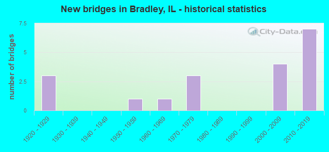
- New bridges - historical statistics
- 31920-1929
- 11950-1959
- 11960-1969
- 31970-1979
- 42000-2009
- 72010-2019


- Bridge Condition - Deck
- 8.3%Very good
- 41.7%Good
- 16.7%Satisfactory
- 33.3%Fair

- Bridge Condition - Superstructure
- 16.7%Very good
- 41.7%Good
- 16.7%Satisfactory
- 25.0%Fair

- Bridge Condition - Substructure
- 33.3%Very good
- 33.3%Good
- 16.7%Satisfactory
- 16.7%Fair

- Bridge Condition - Channel
- 12.5%Very good
- 50.0%Satisfactory
- 37.5%Fair
Find on map >> Show street view
Structure Number: 460126, Location: 3.2 MI N OF ILL 17 (Lat: 41.162731, Lng: -87.844131), Route carried "on" structure: Other road , Year Built: 2002, Status: Open, Structure Length: 6.60m (21.65ft), Average Daily Traffic: 7,800 (year 2021), Truck Traffic: 3%, Average Future Daily Traffic: 11,026 (year 2032), Design Load: HS 20, Features Intersected: FAI 057, Facility Carried by Structure: ARMOUR RD/FAU 6176
Minimum Vertical Clearance: 30+ m (98+ ft), Kilometerpoint: 3.798, Lanes on structure: 4, Lanes under structure: 4, Owner: State Highway Agency, Approaching Roadway Width: 19.3m (63.3ft), Skew: 1 degrees, Material/Design: Steel continuous, Design/Construction: Stringer/Multi-beam, Number Of Spans In Main Unit: 4, Length of Maximum Span: 25.2m (82.7ft), Curb or Sidewalk Widths: Left: 0.0m, Right: 1.6m (5.2ft), Curb-To-Curb Width: 16.4m (53.8ft), Out-to-Out Width: 21.2m (69.6ft)
Condition: Deck: Fair, Superstructure: Good, Substructure: Good, Operating Rating: 72.6 metric tons, Method Used To Determine Operating Rating: Load Factor (LF) rating reported by rating factor (RF) method using MS18 loading, Inventory Rating: 36.0 metric tons, Method Used To Determine Inventory Rating: Load Factor (LF) rating reported by rating factor (RF) method using MS18 loading, Structural Evaluation: Better than present minimum criteria, Deck Geometry: Meets minimum limits, Underclear: Meets minimum limits, Approach Roadway Alignment: Equal to present minimum criteria, Designated Inspection Frequency: Every 24 months, Inspection Date: January 2021, Deck Structure Type: Concrete Cast-file-Place, Wearing Surface/Protective System: Deck Protection: Epoxy Coated Reinforcing
Find on map >> Show street view
Structure Number: 460139, Location: 2.0 MI N OF IL 17 (Lat: 41.148139, Lng: -87.838211), Route carried "on" structure: Other road , Year Built: 2018, Status: Open, Structure Length: 6.48m (21.26ft), Average Daily Traffic: 5,000 (year 2021), Truck Traffic: 6%, Average Future Daily Traffic: 6,875 (year 2038), Design Load: HS 25 or greater, Features Intersected: I-57, Facility Carried by Structure: North Street
Minimum Vertical Clearance: 30+ m (98+ ft), Kilometerpoint: 2.977, Lanes on structure: 4, Lanes under structure: 4, Owner: State Highway Agency, Approaching Roadway Width: 14.0m (45.9ft), Skew: 1 degrees, Material/Design: Steel continuous, Design/Construction: Stringer/Multi-beam, Number Of Spans In Main Unit: 2, Length of Maximum Span: 32.4m (106.3ft), Curb or Sidewalk Widths: Left: 2.4m (7.9ft), Right: 0.0m, Curb-To-Curb Width: 14.0m (45.9ft), Out-to-Out Width: 18.9m (62.0ft)
Condition: Deck: Good, Superstructure: Very good, Substructure: Very good, Operating Rating: 42.1 metric tons, Method Used To Determine Operating Rating: Load and Resistance Factor Rating (LRFR) rating reported by rating factor(RF) method using HL-93 loadings, Inventory Rating: 32.7 metric tons, Method Used To Determine Inventory Rating: Load and Resistance Factor Rating (LRFR) rating reported by rating factor(RF) method using HL-93 loadings, Structural Evaluation: Equal to present desirable criteria, Deck Geometry: High priority of replacement, Underclear: Equal to present minimum criteria, Approach Roadway Alignment: Superior to present desirable criteria, Designated Inspection Frequency: Every 24 months, Inspection Date: November 2021, Deck Structure Type: Concrete Cast-file-Place, Wearing Surface/Protective System: Deck Protection: Epoxy Coated Reinforcing
Find on map >> Show street view
Structure Number: 460144, Location: I-57 & IL 50 INTRCHG (Lat: 41.168714, Lng: -87.851075), Route carried "on" structure: Interstate 57, Year Built: 2012, Status: Open, Structure Length: 7.00m (22.97ft), Average Daily Traffic: 14,750 (year 2019), Truck Traffic: 27%, Average Future Daily Traffic: 17,189 (year 2032), Design Load: HS 20, Features Intersected: IL 50
Minimum Vertical Clearance: 30+ m (98+ ft), Kilometerpoint: 507.686, Lanes on structure: 3, Lanes under structure: 4, Base Highway Network: Yes, Owner: State Highway Agency, Approaching Roadway Width: 17.9m (58.7ft), Skew: 1 degrees, Material/Design: Steel continuous, Design/Construction: Stringer/Multi-beam, Number Of Spans In Main Unit: 4, Length of Maximum Span: 20.7m (67.9ft), Curb-To-Curb Width: 17.9m (58.7ft), Out-to-Out Width: 19.0m (62.3ft)
Condition: Deck: Good, Superstructure: Good, Substructure: Very good, Operating Rating: 67.1 metric tons, Method Used To Determine Operating Rating: Load Factor (LF) rating reported by rating factor (RF) method using MS18 loading, Inventory Rating: 40.2 metric tons, Method Used To Determine Inventory Rating: Load Factor (LF) rating reported by rating factor (RF) method using MS18 loading, Structural Evaluation: Better than present minimum criteria, Deck Geometry: Better than present minimum criteria, Underclear: Somewhat better than minimum adequacy, Approach Roadway Alignment: Equal to present desirable criteria, Designated Inspection Frequency: Every 24 months, Inspection Date: January 2021, Deck Structure Type: Concrete Cast-file-Place, Wearing Surface/Protective System: Deck Protection: Epoxy Coated Reinforcing
Find on map >> Show street view
Structure Number: 460145, Location: I-57 & IL 50 INTRCHG (Lat: 41.168769, Lng: -87.851314), Route carried "on" structure: Interstate 57, Year Built: 2012, Status: Open, Structure Length: 7.01m (23.00ft), Average Daily Traffic: 16,350 (year 2021), Truck Traffic: 27%, Average Future Daily Traffic: 15,090 (year 2033), Design Load: HS 20, Features Intersected: IL 50
Minimum Vertical Clearance: 30+ m (98+ ft), Kilometerpoint: 507.702, Lanes on structure: 3, Lanes under structure: 3, Base Highway Network: Yes, Owner: State Highway Agency, Approaching Roadway Width: 18.1m (59.4ft), Skew: 1 degrees, Material/Design: Steel continuous, Design/Construction: Stringer/Multi-beam, Number Of Spans In Main Unit: 4, Length of Maximum Span: 20.7m (67.9ft), Curb-To-Curb Width: 18.1m (59.4ft), Out-to-Out Width: 19.2m (63.0ft)
Condition: Deck: Good, Superstructure: Good, Substructure: Very good, Operating Rating: 89.1 metric tons, Method Used To Determine Operating Rating: Load Factor (LF) rating reported by rating factor (RF) method using MS18 loading, Inventory Rating: 47.6 metric tons, Method Used To Determine Inventory Rating: Load Factor (LF) rating reported by rating factor (RF) method using MS18 loading, Structural Evaluation: Better than present minimum criteria, Deck Geometry: Better than present minimum criteria, Approach Roadway Alignment: Equal to present desirable criteria, Designated Inspection Frequency: Every 24 months, Inspection Date: January 2021, Deck Structure Type: Concrete Cast-file-Place, Wearing Surface/Protective System: Deck Protection: Epoxy Coated Reinforcing
Find on map >> Show street view
Structure Number: 463004, Location: .1 W ST. GEORGE (Lat: 41.192600, Lng: -87.777700), Route carried "on" structure: County highway , Year Built: 1955, Status: Open, Structure Length: 2.68m (8.79ft), Average Daily Traffic: 1,900 (year 2021), Truck Traffic: 16%, Average Future Daily Traffic: 2,757 (year 2032), Design Load: HS 15, Features Intersected: EXLINE SL, Facility Carried by Structure: CH 8
Minimum Vertical Clearance: 30+ m (98+ ft), Kilometerpoint: 4.216, Lanes on structure: 2, Owner: County Highway Agency, Approaching Roadway Width: 7.3m (24.0ft), Material/Design: Steel continuous, Design/Construction: Stringer/Multi-beam, Number Of Spans In Main Unit: 2, Length of Maximum Span: 12.8m (42.0ft), Curb-To-Curb Width: 7.3m (24.0ft), Out-to-Out Width: 8.5m (27.9ft)
Condition: Deck: Fair, Superstructure: Fair, Substructure: Satisfactory, Channel: Fair, Operating Rating: 40.5 metric tons, Method Used To Determine Operating Rating: Load Factor (LF) rating reported by rating factor (RF) method using MS18 loading, Inventory Rating: 24.3 metric tons, Method Used To Determine Inventory Rating: Load Factor (LF) rating reported by rating factor (RF) method using MS18 loading, Structural Evaluation: Somewhat better than minimum adequacy, Deck Geometry: Meets minimum limits, Waterway Adequacy: Equal to present minimum criteria, Approach Roadway Alignment: Equal to present desirable criteria, Length Of Structure Improvement: 3.47m (11.38ft), Designated Inspection Frequency: Every 24 months, Inspection Date: May 2020, Bridge Improvement Cost: $260,000, Roadway Improvement Cost: $26,000, Total Project Cost: $390,000, Deck Structure Type: Concrete Cast-file-Place, Wearing Surface/Protective System: Wearing Surface: Bituminous
Find on map >> Show street view
Structure Number: 46302, Location: 2.6 MI E BOURBONNAIS (Lat: 41.162903, Lng: -87.817792), Route carried "on" structure: Other road , Year Built: 1961, Status: Open, Structure Length: 1.52m (4.99ft), Average Daily Traffic: 4,650 (year 2021), Truck Traffic: 11%, Average Future Daily Traffic: 8,216 (year 2032), Design Load: HS 15, Features Intersected: SOLDIER CR, Facility Carried by Structure: CH 44
Minimum Vertical Clearance: 30+ m (98+ ft), Kilometerpoint: 6.035, Lanes on structure: 2, Owner: County Highway Agency, Approaching Roadway Width: 7.3m (24.0ft), Skew: 1 degrees, Material/Design: Concrete, Design/Construction: Channel Beam, Number Of Spans In Main Unit: 2, Length of Maximum Span: 7.3m (24.0ft), Curb-To-Curb Width: 7.3m (24.0ft), Out-to-Out Width: 8.0m (26.2ft)
Condition: Deck: Fair, Superstructure: Fair, Substructure: Satisfactory, Channel: Fair, Operating Rating: 47.6 metric tons, Method Used To Determine Operating Rating: Load Factor (LF) rating reported by rating factor (RF) method using MS18 loading, Inventory Rating: 28.5 metric tons, Method Used To Determine Inventory Rating: Load Factor (LF) rating reported by rating factor (RF) method using MS18 loading, Structural Evaluation: Somewhat better than minimum adequacy, Deck Geometry: High priority of replacement, Waterway Adequacy: Equal to present minimum criteria, Approach Roadway Alignment: Equal to present desirable criteria, Length Of Structure Improvement: 2.29m (7.51ft), Designated Inspection Frequency: Every 24 months, Inspection Date: April 2020, Bridge Improvement Cost: $116,000, Roadway Improvement Cost: $12,000, Total Project Cost: $174,000, Deck Structure Type: Concrete Precast Panels, Wearing Surface/Protective System: Wearing Surface: Bituminous
Find on map >> Show street view
Structure Number: 463299, Location: 0.25 MI E OF I-57 (Lat: 41.148178, Lng: -87.832586), Route carried "on" structure: County highway , Year Built: 1971, Status: Open, Structure Length: 3.05m (10.01ft), Average Daily Traffic: 2,350 (year 2021), Truck Traffic: 2%, Average Future Daily Traffic: 3,405 (year 2032), Design Load: HS 20, Features Intersected: SOLDIERS CREEK, Facility Carried by Structure: TR 87A
Minimum Vertical Clearance: 30+ m (98+ ft), Kilometerpoint: 0.016, Lanes on structure: 2, Owner: City or Municipal Highway Agency, Approaching Roadway Width: 6.1m (20.0ft), Skew: 3 degrees, Material/Design: Concrete, Design/Construction: Channel Beam, Number Of Spans In Main Unit: 3, Length of Maximum Span: 10.1m (33.1ft), Curb-To-Curb Width: 8.6m (28.2ft), Out-to-Out Width: 9.3m (30.5ft)
Condition: Deck: Fair, Superstructure: Fair, Substructure: Good, Channel: Satisfactory, Operating Rating: 54.8 metric tons, Method Used To Determine Operating Rating: Load Factor (LF) rating reported by rating factor (RF) method using MS18 loading, Inventory Rating: 32.7 metric tons, Method Used To Determine Inventory Rating: Load Factor (LF) rating reported by rating factor (RF) method using MS18 loading, Structural Evaluation: Somewhat better than minimum adequacy, Deck Geometry: Meets minimum limits, Waterway Adequacy: Equal to present minimum criteria, Approach Roadway Alignment: Equal to present desirable criteria, Designated Inspection Frequency: Every 24 months, Inspection Date: April 2020, Deck Structure Type: Concrete Precast Panels, Wearing Surface/Protective System: Wearing Surface: Bituminous, Membrane: Built-up
Find on map >> Show street view
Structure Number: 463306, Location: .5 MI SW ST GEORGE (Lat: 41.191411, Lng: -87.779739), Route carried "on" structure: County highway , Year Built: 1974, Status: Open, Structure Length: 2.99m (9.81ft), Average Daily Traffic: 500 (year 2021), Truck Traffic: 4%, Average Future Daily Traffic: 703 (year 2032), Design Load: HS 15, Features Intersected: EXLINE SLOUGH, Facility Carried by Structure: TR 172
Minimum Vertical Clearance: 30+ m (98+ ft), Kilometerpoint: 11.571, Lanes on structure: 2, Owner: Town or Township Highway Agency, Approaching Roadway Width: 6.1m (20.0ft), Skew: 3 degrees, Material/Design: Concrete, Design/Construction: Channel Beam, Number Of Spans In Main Unit: 3, Length of Maximum Span: 9.8m (32.2ft), Curb-To-Curb Width: 7.4m (24.3ft), Out-to-Out Width: 8.1m (26.6ft)
Condition: Deck: Satisfactory, Superstructure: Satisfactory, Substructure: Fair, Channel: Satisfactory, Operating Rating: 54.4 metric tons, Method Used To Determine Operating Rating: Load Factor (LF) rating reported by rating factor (RF) method using MS18 loading, Inventory Rating: 32.7 metric tons, Method Used To Determine Inventory Rating: Load Factor (LF) rating reported by rating factor (RF) method using MS18 loading, Structural Evaluation: Somewhat better than minimum adequacy, Deck Geometry: Meets minimum limits, Waterway Adequacy: Equal to present minimum criteria, Approach Roadway Alignment: Equal to present desirable criteria, Designated Inspection Frequency: Every 24 months, Inspection Date: May 2020, Deck Structure Type: Concrete Precast Panels, Wearing Surface/Protective System: Wearing Surface: Gravel
Find on map >> Show street view
Structure Number: 463354, Location: 1 MI N OF ST GEORGE (Lat: 41.207281, Lng: -87.776447), Route carried "on" structure: County highway , Year Built: 1979, Status: Open, Structure Length: 2.47m (8.10ft), Average Daily Traffic: 75 (year 2021), Average Future Daily Traffic: 81 (year 2032), Design Load: HS 20, Features Intersected: EXLINE SLOUGH, Facility Carried by Structure: TR 39
Minimum Vertical Clearance: 30+ m (98+ ft), Kilometerpoint: 3.540, Lanes on structure: 2, Owner: Town or Township Highway Agency, Approaching Roadway Width: 5.5m (18.0ft), Material/Design: Prestressed concrete, Design/Construction: Box Beam or Girders - Multiple, Number Of Spans In Main Unit: 3, Length of Maximum Span: 8.2m (26.9ft), Curb-To-Curb Width: 7.3m (24.0ft), Out-to-Out Width: 8.0m (26.2ft)
Condition: Deck: Good, Superstructure: Good, Substructure: Fair, Channel: Satisfactory, Operating Rating: 44.4 metric tons, Method Used To Determine Operating Rating: Assigned rating based on Load Factor Design (LFD) reported by rating factor (RF) using MS18 loading, Inventory Rating: 32.4 metric tons, Method Used To Determine Inventory Rating: Assigned rating based on Load Factor Design (LFD) reported by rating factor (RF) using MS18 loading, Structural Evaluation: Somewhat better than minimum adequacy, Deck Geometry: Equal to present minimum criteria, Waterway Adequacy: Equal to present minimum criteria, Approach Roadway Alignment: Equal to present desirable criteria, Designated Inspection Frequency: Every 24 months, Inspection Date: May 2020, Deck Structure Type: Concrete Precast Panels
Find on map >> Show street view
Structure Number: 463489, Location: 4500E 3000N (Lat: 41.163200, Lng: -87.790075), Route carried "on" structure: County highway , Year Built: 2006, Status: Open, Structure Length: 2.94m (9.65ft), Average Daily Traffic: 4,050 (year 2021), Truck Traffic: 3%, Average Future Daily Traffic: 4,162 (year 2032), Design Load: HS 20, Features Intersected: EXLINE SL, Facility Carried by Structure: CH 44
Minimum Vertical Clearance: 30+ m (98+ ft), Kilometerpoint: 2.317, Lanes on structure: 2, Owner: County Highway Agency, Approaching Roadway Width: 11.0m (36.1ft), Skew: 3 degrees, Material/Design: Prestressed concrete, Design/Construction: Box Beam or Girders - Multiple, Number Of Spans In Main Unit: 3, Length of Maximum Span: 12.6m (41.3ft), Curb-To-Curb Width: 11.0m (36.1ft), Out-to-Out Width: 11.0m (36.1ft)
Condition: Deck: Satisfactory, Superstructure: Satisfactory, Substructure: Good, Channel: Satisfactory, Operating Rating: 44.1 metric tons, Method Used To Determine Operating Rating: Assigned rating based on Load Factor Design (LFD) reported by rating factor (RF) using MS18 loading, Inventory Rating: 32.4 metric tons, Method Used To Determine Inventory Rating: Assigned rating based on Load Factor Design (LFD) reported by rating factor (RF) using MS18 loading, Structural Evaluation: Equal to present minimum criteria, Deck Geometry: Somewhat better than minimum adequacy, Waterway Adequacy: Equal to present minimum criteria, Approach Roadway Alignment: Equal to present desirable criteria, Designated Inspection Frequency: Every 24 months, Inspection Date: April 2020, Deck Structure Type: Concrete Precast Panels, Wearing Surface/Protective System: Wearing Surface: Bituminous, Membrane: Built-up
Find on map >> Show street view
Structure Number: 463497, Location: 4 MI NE BOURBONAIS (Lat: 41.177831, Lng: -87.785214), Route carried "on" structure: County highway , Year Built: 2008, Status: Open, Structure Length: 3.26m (10.70ft), Average Daily Traffic: 2,600 (year 2021), Truck Traffic: 5%, Average Future Daily Traffic: 2,919 (year 2032), Design Load: HS 20, Features Intersected: EXLINE SLOUGH, Facility Carried by Structure: TR 63
Minimum Vertical Clearance: 30+ m (98+ ft), Kilometerpoint: 2.736, Lanes on structure: 2, Owner: Town or Township Highway Agency, Approaching Roadway Width: 9.1m (29.9ft), Material/Design: Prestressed concrete, Design/Construction: Box Beam or Girders - Multiple, Number Of Spans In Main Unit: 3, Length of Maximum Span: 15.2m (49.9ft), Curb-To-Curb Width: 9.1m (29.9ft), Out-to-Out Width: 9.1m (29.9ft)
Condition: Deck: Good, Superstructure: Good, Substructure: Good, Channel: Fair, Operating Rating: 44.1 metric tons, Method Used To Determine Operating Rating: Assigned rating based on Load Factor Design (LFD) reported by rating factor (RF) using MS18 loading, Inventory Rating: 32.4 metric tons, Method Used To Determine Inventory Rating: Assigned rating based on Load Factor Design (LFD) reported by rating factor (RF) using MS18 loading, Structural Evaluation: Better than present minimum criteria, Deck Geometry: Meets minimum limits, Waterway Adequacy: Equal to present minimum criteria, Approach Roadway Alignment: Equal to present desirable criteria, Designated Inspection Frequency: Every 48 months, Inspection Date: April 2020, Deck Structure Type: Concrete Precast Panels, Wearing Surface/Protective System: Wearing Surface: Bituminous, Membrane: Built-up
Find on map >> Show street view
Structure Number: 463506, Location: 2.7 MI NE BOURBONAIS (Lat: 41.177450, Lng: -87.809869), Route carried "on" structure: County highway , Year Built: 2019, Status: Open, Structure Length: 2.18m (7.15ft), Average Daily Traffic: 2,600 (year 2021), Truck Traffic: 5%, Average Future Daily Traffic: 3,125 (year 2038), Design Load: HS 25 or greater, Features Intersected: SOLDIERS CREEK, Facility Carried by Structure: TR 063
Minimum Vertical Clearance: 30+ m (98+ ft), Kilometerpoint: 0.676, Lanes on structure: 2, Owner: Town or Township Highway Agency, Approaching Roadway Width: 9.8m (32.2ft), Material/Design: Prestressed concrete, Design/Construction: Box Beam or Girders - Multiple, Number Of Spans In Main Unit: 1, Length of Maximum Span: 21.4m (70.2ft), Curb-To-Curb Width: 9.8m (32.2ft), Out-to-Out Width: 9.8m (32.2ft)
Condition: Deck: Very good, Superstructure: Very good, Substructure: Very good, Channel: Very good, Operating Rating: 42.1 metric tons, Method Used To Determine Operating Rating: Assigned ratings based on Load and Resistance Factor Design (LRFD) reported by rating factor (RF) using HL93 loadings, Inventory Rating: 32.4 metric tons, Method Used To Determine Inventory Rating: Assigned ratings based on Load and Resistance Factor Design (LRFD) reported by rating factor (RF) using HL93 loadings, Structural Evaluation: Equal to present desirable criteria, Deck Geometry: Meets minimum limits, Waterway Adequacy: Equal to present desirable criteria, Approach Roadway Alignment: Equal to present desirable criteria, Designated Inspection Frequency: Every 48 months, Inspection Date: September 2021, Deck Structure Type: Concrete Cast-file-Place, Wearing Surface/Protective System: Wearing Surface: Bituminous, Membrane: Built-up
Find on map >> Show street view
Structure Number: 460126, Location: 3.2 MI N OF ILL 17 (Lat: 41.162731, Lng: -87.844131), Route carried "under" structure: Interstate 57, Year Built: 2002, Structure Length: 0. m, Average Daily Traffic: 29,500 (year 2019), Truck Traffic: 27%, Features Intersected: FAI 057, Facility Carried by Structure: ARMOUR RD/FAU 6176
Minimum Vertical Clearance: 5.26m (17.26ft), Kilometerpoint: 506.785, Lanes on structure: 4, Lanes under structure: 4, Material/Design: Steel continuous, Design/Construction: Stringer/Multi-beam, Length of Maximum Span: 25.2m (82.7ft)
Find on map >> Show street view
Structure Number: 460139, Location: 2.0 MI N OF IL 17 (Lat: 41.148139, Lng: -87.838211), Route carried "under" structure: Interstate 57, Year Built: 2018, Structure Length: 0. m, Average Daily Traffic: 29,500 (year 2019), Truck Traffic: 27%, Features Intersected: I-57, Facility Carried by Structure: North Street
Minimum Vertical Clearance: 5.18m (16.99ft), Kilometerpoint: 505.095, Lanes on structure: 4, Lanes under structure: 4, Material/Design: Steel continuous, Design/Construction: Stringer/Multi-beam, Length of Maximum Span: 32.4m (106.3ft)
Find on map >> Show street view
Structure Number: 460144, Location: I-57 & IL 50 INTRCHG (Lat: 41.168575, Lng: -87.851308), Route carried "under" structure: State highway 50, Year Built: 2012, Structure Length: 0. m, Average Daily Traffic: 24,000 (year 2021), Truck Traffic: 5%, Features Intersected: IL 50, Facility Carried by Structure: I-57 SB
Minimum Vertical Clearance: 4.55m (14.93ft), Kilometerpoint: 8.304, Lanes on structure: 3, Lanes under structure: 4, Material/Design: Steel continuous, Design/Construction: Stringer/Multi-beam, Length of Maximum Span: 20.7m (67.9ft)
Find on map >> Show street view
Structure Number: 460145, Location: I-57 & IL 50 INTRCHG (Lat: 41.168769, Lng: -87.851314), Route carried "under" structure: State highway 50, Year Built: 2012, Structure Length: 0. m, Average Daily Traffic: 24,000 (year 2021), Truck Traffic: 5%, Features Intersected: IL 50, Facility Carried by Structure: I-57 NB
Minimum Vertical Clearance: 5.31m (17.42ft), Kilometerpoint: 8.320, Lanes on structure: 3, Lanes under structure: 3, Material/Design: Steel continuous, Design/Construction: Stringer/Multi-beam, Length of Maximum Span: 20.7m (67.9ft)
Find on map >> Show street view
Structure Number: 4663, Location: 1 BLOCK W SCHULYER (Lat: 41.142039, Lng: -87.861694), Route carried "under" structure: Other road , Year Built: 1925, Structure Length: 0. m, Average Daily Traffic: 4,900 (year 2021), Truck Traffic: 7%, Features Intersected: FAU 6179 BROADWAY, Facility Carried by Structure: ICG RR
Minimum Vertical Clearance: 4.01m (13.16ft), Kilometerpoint: 1.239, Lanes under structure: 2, Material/Design: Prestressed concrete, Design/Construction: Slab, Length of Maximum Span: 6.7m (22.0ft)
Find on map >> Show street view
Structure Number: 466301, Location: 1 BLOCK W SCHULYER (Lat: 41.142014, Lng: -87.861506), Route carried "under" structure: Other road , Year Built: 1925, Structure Length: 0. m, Average Daily Traffic: 4,900 (year 2021), Truck Traffic: 7%, Features Intersected: FAU 6179 BROADWAY ST, Facility Carried by Structure: ICG RR
Minimum Vertical Clearance: 4.01m (13.16ft), Kilometerpoint: 1.255, Lanes under structure: 2, Material/Design: Prestressed concrete, Design/Construction: Slab, Length of Maximum Span: 6.7m (22.0ft)
Find on map >> Show street view
Structure Number: 466302, Location: 1 BLOCK W SCHULYER (Lat: 41.141992, Lng: -87.861319), Route carried "under" structure: Other road , Year Built: 1925, Structure Length: 0. m, Average Daily Traffic: 4,900 (year 2021), Truck Traffic: 7%, Features Intersected: FAU 6179 BROADWAY ST, Facility Carried by Structure: ICG RR
Minimum Vertical Clearance: 4.01m (13.16ft), Kilometerpoint: 1.271, Lanes under structure: 2, Material/Design: Prestressed concrete, Design/Construction: Slab, Length of Maximum Span: 6.7m (22.0ft)