Bridge Statistics for Bon Air, Virginia (VA)
Condition, Traffic, Stress, Structural Evaluation, Project Costs
- National Bridge Inventory (NBI) Statistics
- 29Number of bridges
- 256ft / 77.8mTotal length
- $7,015,000Total costs
- 863,678Total average daily traffic
- 12,743Total average daily truck traffic
- National Bridge Inventory (NBI) Registered Bridges for Bon Air
- No street view available for this location
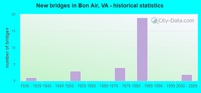
- New bridges - historical statistics
- 11930-1939
- 31950-1959
- 41970-1979
- 191980-1989
- 22000-2009


- Bridge Condition - Deck
- 61.5%Good
- 30.8%Satisfactory
- 7.7%Fair

- Bridge Condition - Superstructure
- 23.1%Good
- 61.5%Satisfactory
- 15.4%Fair

- Bridge Condition - Substructure
- 7.7%Good
- 61.5%Satisfactory
- 30.8%Fair

- Bridge Condition - Channel
- 33.3%Satisfactory
- 50.0%Fair
- 16.7%Poor

- Bridge Condition - Culverts
- 11.1%Good
- 77.8%Satisfactory
- 11.1%Fair
Find on map >> Show street view
Structure Number: 5014, Location: 0.49 Fr 624 & 0.05 To2561 (Lat: 37.502819, Lng: -77.632150), Route carried "on" structure: US 60, Year Built: 1935, Status: Open, Structure Length: 0.69m (2.26ft), Average Daily Traffic: 21,589 (year 2020), Truck Traffic: 1%, Average Future Daily Traffic: 30,225 (year 2040), Features Intersected: FALLING CREEK, Facility Carried by Structure: MIDLOTHIAN TPK EBL
Minimum Vertical Clearance: 30+ m (98+ ft), Kilometerpoint: 286.669, Lanes on structure: 2, Base Highway Network: Yes, Owner: State Highway Agency, Approaching Roadway Width: 12.2m (40.0ft), Material/Design: Concrete, Design/Construction: Slab, Number Of Spans In Main Unit: 1, Length of Maximum Span: 6.3m (20.7ft), Curb-To-Curb Width: 12.0m (39.4ft), Out-to-Out Width: 18.6m (61.0ft)
Condition: Deck: Good, Superstructure: Good, Substructure: Satisfactory, Channel: Fair, Operating Rating: 28.1 metric tons, Method Used To Determine Operating Rating: Field evaluation and documented engineering judgment, Inventory Rating: 16.3 metric tons, Method Used To Determine Inventory Rating: Field evaluation and documented engineering judgment, Structural Evaluation: Meets minimum limits, Deck Geometry: Better than present minimum criteria, Waterway Adequacy: Equal to present minimum criteria, Approach Roadway Alignment: Equal to present desirable criteria, Designated Inspection Frequency: Every 24 months, Inspection Date: October 2020, Deck Structure Type: Concrete Cast-file-Place, Wearing Surface/Protective System: Wearing Surface: Bituminous
Find on map >> Show street view
Structure Number: 5015, Location: 0.49 Fr 624 & 0.81 To 727 (Lat: 37.502978, Lng: -77.632164), Route carried "on" structure: US 60, Year Built: 1959, Status: Open, Structure Length: 0.63m (2.07ft), Average Daily Traffic: 21,589 (year 2020), Truck Traffic: 1%, Average Future Daily Traffic: 30,225 (year 2040), Design Load: HS 20, Features Intersected: FALLING CREEK, Facility Carried by Structure: MIDLOTHIAN TPK WBL
Minimum Vertical Clearance: 30+ m (98+ ft), Kilometerpoint: 286.671, Lanes on structure: 2, Base Highway Network: Yes, Owner: State Highway Agency, Approaching Roadway Width: 14.0m (45.9ft), Material/Design: Concrete, Design/Construction: Culvert, Number Of Spans In Main Unit: 2, Length of Maximum Span: 3.0m (9.8ft)
Condition: Channel: Satisfactory, Culverts: Satisfactory, Operating Rating: 54.4 metric tons, Method Used To Determine Operating Rating: Field evaluation and documented engineering judgment, Inventory Rating: 32.7 metric tons, Method Used To Determine Inventory Rating: Field evaluation and documented engineering judgment, Structural Evaluation: Equal to present minimum criteria, Waterway Adequacy: Equal to present minimum criteria, Approach Roadway Alignment: Equal to present desirable criteria, Designated Inspection Frequency: Every 24 months, Inspection Date: July 2021
Find on map >> Show street view
Structure Number: 5018, Location: 0.32 Fr 755 & 0.85 To 678 (Lat: 37.495464, Lng: -77.561803), Route carried "on" structure: US 60, Year Built: 1988, Status: Open, Structure Length: 8.96m (29.40ft), Average Daily Traffic: 25,978 (year 2020), Truck Traffic: 1%, Average Future Daily Traffic: 36,369 (year 2040), Design Load: HS 20+Mod, Features Intersected: EB RTE 76 (POWHITE PKWY), Facility Carried by Structure: MIDLOTHIAN TRNPIKE
Minimum Vertical Clearance: 30+ m (98+ ft), Kilometerpoint: 293.345, Lanes on structure: 4, Lanes under structure: 8, Base Highway Network: Yes, Owner: State Highway Agency, Approaching Roadway Width: 19.8m (65.0ft), Skew: 2 degrees, Material/Design: Steel continuous, Design/Construction: Stringer/Multi-beam, Number Of Spans In Main Unit: 3, Length of Maximum Span: 34.0m (111.5ft), Curb-To-Curb Width: 19.1m (62.7ft), Out-to-Out Width: 20.1m (65.9ft)
Condition: Deck: Good, Superstructure: Satisfactory, Substructure: Satisfactory, Operating Rating: 72.6 metric tons, Method Used To Determine Operating Rating: Load and Resistance Factor (LRFR), Inventory Rating: 56.2 metric tons, Method Used To Determine Inventory Rating: Load and Resistance Factor (LRFR), Structural Evaluation: Equal to present minimum criteria, Deck Geometry: Equal to present minimum criteria, Underclear: High priority of corrective action, Approach Roadway Alignment: Equal to present desirable criteria, Designated Inspection Frequency: Every 24 months, Inspection Date: June 2020, Deck Structure Type: Concrete Cast-file-Place, Wearing Surface/Protective System: Deck Protection: Epoxy Coated Reinforcing
Find on map >> Show street view
Structure Number: 5022, Location: .58 FR 686 .03 TO WCL RIC (Lat: 37.526044, Lng: -77.528847), Route carried "on" structure: State highway 76, Year Built: 1972, Status: Open, Structure Length: 6.22m (20.41ft), Average Daily Traffic: 29,047 (year 2020), Truck Traffic: 2%, Average Future Daily Traffic: 40,666 (year 2040), Design Load: HS 20+Mod, Features Intersected: RTE 150 CHIPPENHAM PKWAY, Facility Carried by Structure: WBL POWHITE PARKWY
Minimum Vertical Clearance: 30+ m (98+ ft), Kilometerpoint: 15.350, Lanes on structure: 4, Lanes under structure: 5, Base Highway Network: Yes, Toll: On toll road, Owner: Local Toll Authority, Approaching Roadway Width: 17.4m (57.1ft), Skew: 3 degrees, Material/Design: Steel, Design/Construction: Stringer/Multi-beam, Number Of Spans In Main Unit: 2, Length of Maximum Span: 31.1m (102.0ft), Curb or Sidewalk Widths: Left: 0.3m (1.0ft), Right: 0.3m (1.0ft), Curb-To-Curb Width: 17.4m (57.1ft), Out-to-Out Width: 18.6m (61.0ft)
Condition: Deck: Good, Superstructure: Satisfactory, Substructure: Good, Operating Rating: 72.6 metric tons, Method Used To Determine Operating Rating: Load and Resistance Factor (LRFR), Inventory Rating: 56.2 metric tons, Method Used To Determine Inventory Rating: Load and Resistance Factor (LRFR), Structural Evaluation: Equal to present minimum criteria, Deck Geometry: Meets minimum limits, Underclear: Meets minimum limits, Approach Roadway Alignment: Equal to present desirable criteria, Designated Inspection Frequency: Every 24 months, Inspection Date: July 2021, Deck Structure Type: Concrete Cast-file-Place, Wearing Surface/Protective System: Wearing Surface: Latex Concrete
Find on map >> Show street view
Structure Number: 5024, Location: .58 Fr 686/.03 To WCL Ric (Lat: 37.525178, Lng: -77.528872), Route carried "on" structure: State highway 76, Year Built: 1988, Status: Open, Structure Length: 8.41m (27.59ft), Average Daily Traffic: 49,292 (year 2020), Truck Traffic: 1%, Average Future Daily Traffic: 69,010 (year 2040), Design Load: HS 20+Mod, Features Intersected: ROUTE 150 CHIPPENHAM PKW
Minimum Vertical Clearance: 30+ m (98+ ft), Kilometerpoint: 15.350, Lanes on structure: 3, Lanes under structure: 7, Base Highway Network: Yes, Toll: On toll road, Owner: State Highway Agency, Approaching Roadway Width: 17.1m (56.1ft), Skew: 4 degrees, Material/Design: Steel continuous, Design/Construction: Stringer/Multi-beam, Number Of Spans In Main Unit: 2, Length of Maximum Span: 42.4m (139.1ft), Curb-To-Curb Width: 16.6m (54.5ft), Out-to-Out Width: 17.6m (57.7ft)
Condition: Deck: Satisfactory, Superstructure: Satisfactory, Substructure: Fair, Operating Rating: 88.9 metric tons, Method Used To Determine Operating Rating: Load and Resistance Factor (LRFR), Inventory Rating: 68.9 metric tons, Method Used To Determine Inventory Rating: Load and Resistance Factor (LRFR), Structural Evaluation: Somewhat better than minimum adequacy, Deck Geometry: Equal to present minimum criteria, Underclear: Somewhat better than minimum adequacy, Approach Roadway Alignment: Equal to present desirable criteria, Designated Inspection Frequency: Every 24 months, Inspection Date: May 2020, Deck Structure Type: Concrete Cast-file-Place, Wearing Surface/Protective System: Deck Protection: Epoxy Coated Reinforcing
Find on map >> Show street view
Structure Number: 5026, Location: .45 Fr 686/.16 To WCL Ric (Lat: 37.523831, Lng: -77.530514), Route carried "on" structure: State highway 76, Year Built: 1988, Status: Open, Structure Length: 4.95m (16.24ft), Average Daily Traffic: 29,047 (year 2020), Truck Traffic: 1%, Average Future Daily Traffic: 40,666 (year 2040), Design Load: HS 20+Mod, Features Intersected: RAMP-B TO RTE.150 SBL
Minimum Vertical Clearance: 30+ m (98+ ft), Kilometerpoint: 15.109, Lanes on structure: 2, Lanes under structure: 2, Base Highway Network: Yes, Toll: On toll road, Owner: State Highway Agency, Approaching Roadway Width: 13.4m (44.0ft), Skew: 3 degrees, Material/Design: Steel, Design/Construction: Stringer/Multi-beam, Number Of Spans In Main Unit: 3, Length of Maximum Span: 22.7m (74.5ft), Curb-To-Curb Width: 13.0m (42.7ft), Out-to-Out Width: 14.0m (45.9ft)
Condition: Deck: Good, Superstructure: Good, Substructure: Satisfactory, Operating Rating: 85.6 metric tons, Method Used To Determine Operating Rating: Load and Resistance Factor (LRFR), Inventory Rating: 66.0 metric tons, Method Used To Determine Inventory Rating: Load and Resistance Factor (LRFR), Structural Evaluation: Equal to present minimum criteria, Deck Geometry: Superior to present desirable criteria, Underclear: Superior to present desirable criteria, Approach Roadway Alignment: Equal to present desirable criteria, Designated Inspection Frequency: Every 24 months, Inspection Date: May 2020, Deck Structure Type: Concrete Cast-file-Place, Wearing Surface/Protective System: Deck Protection: Epoxy Coated Reinforcing
Find on map >> Show street view
Structure Number: 5028, Location: .38 Fr 686 & .20To Rte150 (Lat: 37.523142, Lng: -77.531306), Route carried "on" structure: State highway 76, Year Built: 1988, Status: Open, Structure Length: 4.94m (16.21ft), Average Daily Traffic: 29,047 (year 2020), Truck Traffic: 2%, Average Future Daily Traffic: 40,666 (year 2040), Design Load: HS 20+Mod, Features Intersected: PROP CHINABERRY PKWY
Minimum Vertical Clearance: 30+ m (98+ ft), Kilometerpoint: 14.996, Lanes on structure: 2, Base Highway Network: Yes, Toll: On toll road, Owner: State Highway Agency, Approaching Roadway Width: 15.2m (49.9ft), Skew: 1 degrees, Material/Design: Steel continuous, Design/Construction: Stringer/Multi-beam, Number Of Spans In Main Unit: 2, Length of Maximum Span: 24.1m (79.1ft), Curb-To-Curb Width: 14.8m (48.6ft), Out-to-Out Width: 15.8m (51.8ft)
Condition: Deck: Good, Superstructure: Satisfactory, Substructure: Satisfactory, Operating Rating: 62.6 metric tons, Method Used To Determine Operating Rating: Load and Resistance Factor (LRFR), Inventory Rating: 48.1 metric tons, Method Used To Determine Inventory Rating: Load and Resistance Factor (LRFR), Structural Evaluation: Equal to present minimum criteria, Deck Geometry: Superior to present desirable criteria, Approach Roadway Alignment: Equal to present desirable criteria, Designated Inspection Frequency: Every 24 months, Inspection Date: May 2020, Deck Structure Type: Concrete Cast-file-Place, Wearing Surface/Protective System: Deck Protection: Epoxy Coated Reinforcing
Find on map >> Show street view
Structure Number: 5029, Location: .38 Fr 686 &.20 To Rte150 (Lat: 37.523547, Lng: -77.532067), Route carried "on" structure: State highway 76, Year Built: 1988, Status: Open, Structure Length: 4.30m (14.11ft), Average Daily Traffic: 29,047 (year 2020), Truck Traffic: 2%, Average Future Daily Traffic: 40,666 (year 2040), Design Load: HS 20+Mod, Features Intersected: PROP CHINABERRY PKWY
Minimum Vertical Clearance: 30+ m (98+ ft), Kilometerpoint: 15.028, Lanes on structure: 3, Base Highway Network: Yes, Toll: On toll road, Owner: State Highway Agency, Approaching Roadway Width: 17.1m (56.1ft), Material/Design: Steel continuous, Design/Construction: Stringer/Multi-beam, Number Of Spans In Main Unit: 2, Length of Maximum Span: 20.9m (68.6ft), Curb-To-Curb Width: 16.6m (54.5ft), Out-to-Out Width: 17.6m (57.7ft)
Condition: Deck: Good, Superstructure: Satisfactory, Substructure: Fair, Operating Rating: 65.3 metric tons, Method Used To Determine Operating Rating: Load and Resistance Factor (LRFR), Inventory Rating: 49.9 metric tons, Method Used To Determine Inventory Rating: Load and Resistance Factor (LRFR), Structural Evaluation: Somewhat better than minimum adequacy, Deck Geometry: Equal to present minimum criteria, Approach Roadway Alignment: Equal to present desirable criteria, Designated Inspection Frequency: Every 24 months, Inspection Date: May 2020, Deck Structure Type: Concrete Cast-file-Place, Wearing Surface/Protective System: Deck Protection: Epoxy Coated Reinforcing
Find on map >> Show street view
Structure Number: 503, Location: 0.76 Fr 60 & 0.83 To 686 (Lat: 37.505475, Lng: -77.549786), Route carried "on" structure: State highway 76, Year Built: 1988, Status: Open, Structure Length: 3.17m (10.40ft), Average Daily Traffic: 43,281 (year 2020), Truck Traffic: 1%, Average Future Daily Traffic: 56,474 (year 2040), Design Load: HS 20+Mod, Features Intersected: ROUTE 678 (BUFORD ROAD)
Minimum Vertical Clearance: 30+ m (98+ ft), Kilometerpoint: 12.277, Lanes on structure: 4, Lanes under structure: 2, Base Highway Network: Yes, Toll: On toll road, Owner: State Highway Agency, Approaching Roadway Width: 23.8m (78.1ft), Skew: 30 degrees, Material/Design: Steel, Design/Construction: Stringer/Multi-beam, Number Of Spans In Main Unit: 1, Length of Maximum Span: 30.5m (100.1ft), Curb-To-Curb Width: 22.7m (74.5ft), Out-to-Out Width: 24.3m (79.7ft)
Condition: Deck: Good, Superstructure: Satisfactory, Substructure: Satisfactory, Operating Rating: 83.5 metric tons, Method Used To Determine Operating Rating: Load and Resistance Factor (LRFR), Inventory Rating: 64.4 metric tons, Method Used To Determine Inventory Rating: Load and Resistance Factor (LRFR), Structural Evaluation: Equal to present minimum criteria, Deck Geometry: Superior to present desirable criteria, Approach Roadway Alignment: Equal to present desirable criteria, Designated Inspection Frequency: Every 24 months, Inspection Date: July 2020, Deck Structure Type: Concrete Cast-file-Place, Wearing Surface/Protective System: Deck Protection: Epoxy Coated Reinforcing
Find on map >> Show street view
Structure Number: 5045, Location: 0.51 Fr 60 & 0.69 To 678 (Lat: 37.502425, Lng: -77.556214), Route carried "on" structure: State highway 76, Year Built: 1988, Status: Open, Structure Length: 0.88m (2.89ft), Average Daily Traffic: 43,281 (year 2020), Truck Traffic: 2%, Average Future Daily Traffic: 56,474 (year 2040), Design Load: HS 20+Mod, Features Intersected: BRANCH OF POWHITE CREEK
Minimum Vertical Clearance: 30+ m (98+ ft), Kilometerpoint: 11.166, Lanes on structure: 6, Base Highway Network: Yes, Toll: On toll road, Owner: State Highway Agency, Approaching Roadway Width: 26.2m (86.0ft), Skew: 4 degrees, Material/Design: Concrete, Design/Construction: Culvert, Number Of Spans In Main Unit: 2, Length of Maximum Span: 4.3m (14.1ft)
Condition: Channel: Poor, Culverts: Satisfactory, Operating Rating: 54.4 metric tons, Method Used To Determine Operating Rating: Field evaluation and documented engineering judgment, Inventory Rating: 32.7 metric tons, Method Used To Determine Inventory Rating: Field evaluation and documented engineering judgment, Structural Evaluation: Equal to present minimum criteria, Waterway Adequacy: Equal to present desirable criteria, Approach Roadway Alignment: Equal to present desirable criteria, Designated Inspection Frequency: Every 24 months, Inspection Date: May 2020
Find on map >> Show street view
Structure Number: 5046, Location: 0.58 Fr 60 & 1.02 To 686 (Lat: 37.505261, Lng: -77.550439), Route carried "on" structure: State highway 76, Year Built: 1988, Status: Open, Structure Length: 1.37m (4.49ft), Average Daily Traffic: 43,281 (year 2020), Truck Traffic: 2%, Average Future Daily Traffic: 56,474 (year 2040), Design Load: HS 20+Mod, Features Intersected: POWHITE CREEK, Facility Carried by Structure: POWHITE PARKWAY
Minimum Vertical Clearance: 30+ m (98+ ft), Kilometerpoint: 11.681, Lanes on structure: 6, Base Highway Network: Yes, Toll: On toll road, Owner: State Highway Agency, Approaching Roadway Width: 26.2m (86.0ft), Skew: 4 degrees, Material/Design: Concrete, Design/Construction: Culvert, Number Of Spans In Main Unit: 3, Length of Maximum Span: 4.3m (14.1ft)
Condition: Channel: Fair, Culverts: Satisfactory, Operating Rating: 89.8 metric tons, Method Used To Determine Operating Rating: Field evaluation and documented engineering judgment, Inventory Rating: 89.8 metric tons, Method Used To Determine Inventory Rating: Field evaluation and documented engineering judgment, Structural Evaluation: Equal to present minimum criteria, Waterway Adequacy: Equal to present desirable criteria, Approach Roadway Alignment: Equal to present desirable criteria, Designated Inspection Frequency: Every 24 months, Inspection Date: October 2020
Find on map >> Show street view
Structure Number: 5048, Location: 0.32 Fr 686 & 0.26 To 150 (Lat: 37.522706, Lng: -77.531775), Route carried "on" structure: State highway 76, Year Built: 1988, Status: Open, Structure Length: 1.04m (3.41ft), Average Daily Traffic: 29,047 (year 2020), Truck Traffic: 2%, Average Future Daily Traffic: 40,666 (year 2040), Design Load: HS 20+Mod, Features Intersected: LONG BRANCH, Facility Carried by Structure: POWHITE PKWY EBL
Minimum Vertical Clearance: 30+ m (98+ ft), Kilometerpoint: 14.899, Lanes on structure: 3, Base Highway Network: Yes, Toll: On toll road, Owner: State Highway Agency, Approaching Roadway Width: 17.7m (58.1ft), Material/Design: Concrete, Design/Construction: Culvert, Number Of Spans In Main Unit: 4, Length of Maximum Span: 2.4m (7.9ft)
Condition: Channel: Fair, Culverts: Satisfactory, Operating Rating: 89.8 metric tons, Method Used To Determine Operating Rating: Field evaluation and documented engineering judgment, Inventory Rating: 89.8 metric tons, Method Used To Determine Inventory Rating: Field evaluation and documented engineering judgment, Structural Evaluation: Equal to present minimum criteria, Waterway Adequacy: Equal to present desirable criteria, Approach Roadway Alignment: Equal to present desirable criteria, Designated Inspection Frequency: Every 24 months, Inspection Date: October 2020
Find on map >> Show street view
Structure Number: 5049, Location: 0.26 Fr 686 & 0.32 To 150 (Lat: 37.522850, Lng: -77.532592), Route carried "on" structure: State highway 76, Year Built: 1988, Status: Open, Structure Length: 1.04m (3.41ft), Average Daily Traffic: 29,047 (year 2020), Truck Traffic: 2%, Average Future Daily Traffic: 40,666 (year 2040), Design Load: HS 20+Mod, Features Intersected: LONG BRANCH, Facility Carried by Structure: POWHITE PRKWAY WBL
Minimum Vertical Clearance: 30+ m (98+ ft), Kilometerpoint: 14.803, Lanes on structure: 3, Base Highway Network: Yes, Toll: On toll road, Owner: State Highway Agency, Approaching Roadway Width: 17.7m (58.1ft), Material/Design: Concrete, Design/Construction: Culvert, Number Of Spans In Main Unit: 4, Length of Maximum Span: 2.4m (7.9ft)
Condition: Channel: Fair, Culverts: Satisfactory, Operating Rating: 89.8 metric tons, Method Used To Determine Operating Rating: Field evaluation and documented engineering judgment, Inventory Rating: 89.8 metric tons, Method Used To Determine Inventory Rating: Field evaluation and documented engineering judgment, Structural Evaluation: Equal to present minimum criteria, Waterway Adequacy: Equal to present desirable criteria, Approach Roadway Alignment: Equal to present desirable criteria, Designated Inspection Frequency: Every 24 months, Inspection Date: October 2020
Find on map >> Show street view
Structure Number: 5104, Location: 0.35 frm 727& .54 to 675 (Lat: 37.516581, Lng: -77.615617), Route carried "on" structure: State highway 147, Year Built: 1950, Year Reconstructed: 1987, Status: Open, Structure Length: 0.86m (2.82ft), Average Daily Traffic: 29,782 (year 2020), Truck Traffic: 1%, Average Future Daily Traffic: 32,760 (year 2040), Design Load: H 20, Features Intersected: UNNAMED TRIBUTARY, Facility Carried by Structure: HUGUENOT ROAD
Minimum Vertical Clearance: 30+ m (98+ ft), Kilometerpoint: 1.281, Lanes on structure: 5, Base Highway Network: Yes, Owner: State Highway Agency, Approaching Roadway Width: 19.8m (65.0ft), Skew: 2 degrees, Material/Design: Steel, Design/Construction: Culvert, Number Of Spans In Main Unit: 3, Length of Maximum Span: 2.2m (7.2ft)
Condition: Channel: Satisfactory, Culverts: Satisfactory, Operating Rating: 54.4 metric tons, Method Used To Determine Operating Rating: Field evaluation and documented engineering judgment, Inventory Rating: 32.7 metric tons, Method Used To Determine Inventory Rating: Field evaluation and documented engineering judgment, Structural Evaluation: Equal to present minimum criteria, Waterway Adequacy: Equal to present minimum criteria, Approach Roadway Alignment: Equal to present desirable criteria, Designated Inspection Frequency: Every 24 months, Inspection Date: January 2022
Find on map >> Show street view
Structure Number: 5126, Location: .24 FR 76 & .39 TO 686 (Lat: 37.522086, Lng: -77.528447), Route carried "on" structure: State highway 150, Year Built: 1972, Status: Open, Structure Length: 3.89m (12.76ft), Average Daily Traffic: 32,260 (year 2020), Truck Traffic: 2%, Average Future Daily Traffic: 45,165 (year 2040), Design Load: HS 20+Mod, Features Intersected: POWHITE CREEK
Minimum Vertical Clearance: 30+ m (98+ ft), Kilometerpoint: 8.512, Lanes on structure: 4, Base Highway Network: Yes, Owner: State Highway Agency, Approaching Roadway Width: 23.1m (75.8ft), Skew: 4 degrees, Material/Design: Concrete, Design/Construction: Tee Beam, Number Of Spans In Main Unit: 3, Length of Maximum Span: 13.1m (43.0ft), Curb-To-Curb Width: 23.1m (75.8ft), Out-to-Out Width: 24.0m (78.7ft)
Condition: Deck: Satisfactory, Superstructure: Satisfactory, Substructure: Fair, Channel: Satisfactory, Operating Rating: 56.2 metric tons, Method Used To Determine Operating Rating: Load and Resistance Factor (LRFR), Inventory Rating: 43.5 metric tons, Method Used To Determine Inventory Rating: Load and Resistance Factor (LRFR), Structural Evaluation: Somewhat better than minimum adequacy, Deck Geometry: Superior to present desirable criteria, Waterway Adequacy: Better than present minimum criteria, Approach Roadway Alignment: Equal to present desirable criteria, Designated Inspection Frequency: Every 24 months, Inspection Date: October 2021, Deck Structure Type: Concrete Cast-file-Place, Wearing Surface/Protective System: Wearing Surface: Latex Concrete, Deck Protection: Epoxy Coated Reinforcing
Find on map >> Show street view
Structure Number: 533, Location: .49 FR 686 & .08 TO 718 (Lat: 37.523450, Lng: -77.557203), Route carried "on" structure: County highway 678, Year Built: 1983, Status: Open, Structure Length: 4.65m (15.26ft), Average Daily Traffic: 10,496 (year 2020), Average Future Daily Traffic: 11,546 (year 2040), Design Load: HS 20+Mod, Features Intersected: NS RAILWAY, Facility Carried by Structure: BUFORD ROAD
Minimum Vertical Clearance: 30+ m (98+ ft), Kilometerpoint: 11.070, Lanes on structure: 2, Owner: State Highway Agency, Approaching Roadway Width: 12.2m (40.0ft), Material/Design: Steel, Design/Construction: Stringer/Multi-beam, Number Of Spans In Main Unit: 3, Length of Maximum Span: 15.5m (50.9ft), Curb or Sidewalk Widths: Left: 1.5m (4.9ft), Right: 1.5m (4.9ft), Curb-To-Curb Width: 9.1m (29.9ft), Out-to-Out Width: 12.8m (42.0ft)
Condition: Deck: Satisfactory, Superstructure: Fair, Substructure: Fair, Operating Rating: 61.5 metric tons, Method Used To Determine Operating Rating: Load and Resistance Factor (LRFR), Inventory Rating: 47.4 metric tons, Method Used To Determine Inventory Rating: Load and Resistance Factor (LRFR), Structural Evaluation: Somewhat better than minimum adequacy, Deck Geometry: High priority of corrective action, Underclear: Somewhat better than minimum adequacy, Approach Roadway Alignment: Equal to present desirable criteria, Length Of Structure Improvement: 4.66m (15.29ft), Designated Inspection Frequency: Every 24 months, Inspection Date: August 2021, Bridge Improvement Cost: $555,000, Roadway Improvement Cost: $95,000, Total Project Cost: $845,000, Deck Structure Type: Concrete Precast Panels, Wearing Surface/Protective System: Deck Protection: Epoxy Coated Reinforcing
Find on map >> Show street view
Structure Number: 5332, Location: 0.05 Fr 76 & 0.34 To 150 (Lat: 37.518203, Lng: -77.533669), Route carried "on" structure: County highway 686, Year Built: 1988, Status: Open, Structure Length: 3.08m (10.10ft), Average Daily Traffic: 12,963 (year 2020), Truck Traffic: 1%, Average Future Daily Traffic: 13,942 (year 2040), Design Load: HS 20+Mod, Features Intersected: POWHITE CREEK, Facility Carried by Structure: JAHNKE ROAD
Minimum Vertical Clearance: 30+ m (98+ ft), Kilometerpoint: 2.414, Lanes on structure: 5, Owner: State Highway Agency, Approaching Roadway Width: 24.4m (80.1ft), Skew: 20 degrees, Material/Design: Concrete, Design/Construction: Culvert, Number Of Spans In Main Unit: 6, Length of Maximum Span: 4.9m (16.1ft)
Condition: Channel: Fair, Culverts: Satisfactory, Operating Rating: 54.4 metric tons, Method Used To Determine Operating Rating: Field evaluation and documented engineering judgment, Inventory Rating: 32.7 metric tons, Method Used To Determine Inventory Rating: Field evaluation and documented engineering judgment, Structural Evaluation: Equal to present minimum criteria, Waterway Adequacy: Equal to present desirable criteria, Approach Roadway Alignment: Equal to present desirable criteria, Designated Inspection Frequency: Every 24 months, Inspection Date: October 2020
Find on map >> Show street view
Structure Number: 5333, Location: 0.83 Fr 789 & 0.36 To 150 (Lat: 37.518353, Lng: -77.534967), Route carried "on" structure: County highway 686, Year Built: 1988, Status: Open, Structure Length: 6.22m (20.41ft), Average Daily Traffic: 12,963 (year 2020), Truck Traffic: 1%, Average Future Daily Traffic: 13,942 (year 2040), Design Load: HS 20+Mod, Features Intersected: ROUTE 76
Minimum Vertical Clearance: 30+ m (98+ ft), Kilometerpoint: 2.333, Lanes on structure: 6, Lanes under structure: 5, Owner: State Highway Agency, Approaching Roadway Width: 28.2m (92.5ft), Skew: 21 degrees, Material/Design: Steel continuous, Design/Construction: Stringer/Multi-beam, Number Of Spans In Main Unit: 2, Length of Maximum Span: 32.6m (107.0ft), Curb-To-Curb Width: 29.4m (96.5ft), Out-to-Out Width: 30.4m (99.7ft)
Condition: Deck: Good, Superstructure: Satisfactory, Substructure: Satisfactory, Operating Rating: 73.0 metric tons, Method Used To Determine Operating Rating: Load and Resistance Factor (LRFR), Inventory Rating: 56.3 metric tons, Method Used To Determine Inventory Rating: Load and Resistance Factor (LRFR), Structural Evaluation: Equal to present minimum criteria, Deck Geometry: Superior to present desirable criteria, Underclear: Meets minimum limits, Approach Roadway Alignment: Equal to present desirable criteria, Length Of Structure Improvement: 6.22m (20.41ft), Designated Inspection Frequency: Every 24 months, Inspection Date: August 2021, Bridge Improvement Cost: $100,000, Roadway Improvement Cost: $1,000, Total Project Cost: $110,000, Deck Structure Type: Concrete Cast-file-Place, Wearing Surface/Protective System: Deck Protection: Epoxy Coated Reinforcing
Find on map >> Show street view
Structure Number: 535, Location: .07 FR 1200 & .04 TO 1202 (Lat: 37.517239, Lng: -77.619333), Route carried "on" structure: County highway 1206, Year Built: 1955, Status: Open, Structure Length: 0.73m (2.40ft), Average Daily Traffic: 1,982 (year 2015), Average Future Daily Traffic: 2,435 (year 2040), Design Load: H 20, Features Intersected: UNNAMED TRIBUTARY, Facility Carried by Structure: FEATHERSTONE DRIVE
Minimum Vertical Clearance: 30+ m (98+ ft), Kilometerpoint: 0.573, Lanes on structure: 2, Owner: State Highway Agency, Approaching Roadway Width: 7.3m (24.0ft), Material/Design: Steel, Design/Construction: Culvert, Number Of Spans In Main Unit: 3, Length of Maximum Span: 2.1m (6.9ft)
Condition: Channel: Fair, Culverts: Good, Operating Rating: 54.4 metric tons, Method Used To Determine Operating Rating: Field evaluation and documented engineering judgment, Inventory Rating: 32.7 metric tons, Method Used To Determine Inventory Rating: Field evaluation and documented engineering judgment, Structural Evaluation: Better than present minimum criteria, Waterway Adequacy: Equal to present desirable criteria, Approach Roadway Alignment: Equal to present desirable criteria, Length Of Structure Improvement: 0.61m (2.00ft), Designated Inspection Frequency: Every 24 months, Inspection Date: August 2021, Bridge Improvement Cost: $1,643,000, Roadway Improvement Cost: $357,000, Total Project Cost: $2,000,000
Find on map >> Show street view
Structure Number: 12856, Location: .36 FR 460B &.11 TO 625 (Lat: 37.121486, Lng: -78.050783), Route carried "on" structure: County highway 611, Year Built: 1975, Status: Open, Structure Length: 6.52m (21.39ft), Average Daily Traffic: 468 (year 2017), Average Future Daily Traffic: 683 (year 2040), Design Load: HS 20+Mod, Features Intersected: U. S. 460, Facility Carried by Structure: PINEY GREEN ROAD
Minimum Vertical Clearance: 30+ m (98+ ft), Kilometerpoint: 0.386, Lanes on structure: 2, Lanes under structure: 4, Owner: State Highway Agency, Approaching Roadway Width: 8.8m (28.9ft), Material/Design: Steel continuous, Design/Construction: Stringer/Multi-beam, Number Of Spans In Main Unit: 2, Length of Maximum Span: 32.6m (107.0ft), Curb-To-Curb Width: 8.5m (27.9ft), Out-to-Out Width: 9.8m (32.2ft)
Condition: Deck: Fair, Superstructure: Fair, Substructure: Satisfactory, Operating Rating: 63.6 metric tons, Method Used To Determine Operating Rating: Load and Resistance Factor (LRFR), Inventory Rating: 49.1 metric tons, Method Used To Determine Inventory Rating: Load and Resistance Factor (LRFR), Structural Evaluation: Somewhat better than minimum adequacy, Deck Geometry: Somewhat better than minimum adequacy, Underclear: Equal to present minimum criteria, Approach Roadway Alignment: Equal to present minimum criteria, Length Of Structure Improvement: 6.86m (22.51ft), Designated Inspection Frequency: Every 24 months, Inspection Date: January 2022, Bridge Improvement Cost: $2,700,000, Roadway Improvement Cost: $1,350,000, Total Project Cost: $4,060,000, Deck Structure Type: Concrete Cast-file-Place
Find on map >> Show street view
Structure Number: 27382, Location: 0.48 FR 60 & 1.16 TO 727 (Lat: 37.507681, Lng: -77.632989), Route carried "on" structure: County highway 677, Year Built: 2006, Status: Open, Structure Length: 4.66m (15.29ft), Average Daily Traffic: 8,304 (year 2020), Truck Traffic: 1%, Average Future Daily Traffic: 11,626 (year 2040), Design Load: HS 20+Mod, Features Intersected: FALLING CREEK, Facility Carried by Structure: OLD BUCKINGHAM RD.
Minimum Vertical Clearance: 30+ m (98+ ft), Kilometerpoint: 0.772, Lanes on structure: 2, Owner: State Highway Agency, Approaching Roadway Width: 11.3m (37.1ft), Skew: 1 degrees, Material/Design: Prestressed concrete continuous, Design/Construction: Stringer/Multi-beam, Number Of Spans In Main Unit: 2, Length of Maximum Span: 21.9m (71.9ft), Curb-To-Curb Width: 11.3m (37.1ft), Out-to-Out Width: 12.0m (39.4ft)
Condition: Deck: Satisfactory, Superstructure: Good, Substructure: Satisfactory, Channel: Satisfactory, Operating Rating: 48.6 metric tons, Method Used To Determine Operating Rating: Load and Resistance Factor (LRFR), Inventory Rating: 37.6 metric tons, Method Used To Determine Inventory Rating: Load and Resistance Factor (LRFR), Structural Evaluation: Equal to present minimum criteria, Deck Geometry: Meets minimum limits, Waterway Adequacy: Equal to present desirable criteria, Approach Roadway Alignment: Equal to present desirable criteria, Designated Inspection Frequency: Every 24 months, Inspection Date: September 2020, Deck Structure Type: Concrete Cast-file-Place, Wearing Surface/Protective System: Deck Protection: Epoxy Coated Reinforcing
Find on map >> Show street view
Structure Number: 28528, Location: 1.28 FR 675 & .35 TO 324 (Lat: 37.522939, Lng: -77.569286), Route carried "on" structure: County highway 718, Year Built: 2007, Status: Open, Structure Length: 0.64m (2.10ft), Average Daily Traffic: 6,168 (year 2020), Truck Traffic: 1%, Average Future Daily Traffic: 6,785 (year 2040), Design Load: H 20, Features Intersected: POWHITE CREEK, Facility Carried by Structure: OLD BON AIR ROAD
Minimum Vertical Clearance: 30+ m (98+ ft), Kilometerpoint: 2.060, Lanes on structure: 2, Owner: State Highway Agency, Approaching Roadway Width: 7.6m (24.9ft), Material/Design: Steel, Design/Construction: Culvert, Number Of Spans In Main Unit: 3, Length of Maximum Span: 1.8m (5.9ft)
Condition: Channel: Poor, Culverts: Fair, Operating Rating: 44.5 metric tons, Method Used To Determine Operating Rating: Field evaluation and documented engineering judgment, Inventory Rating: 32.7 metric tons, Method Used To Determine Inventory Rating: Field evaluation and documented engineering judgment, Structural Evaluation: Somewhat better than minimum adequacy, Waterway Adequacy: Equal to present minimum criteria, Approach Roadway Alignment: Equal to present minimum criteria, Designated Inspection Frequency: Every 24 months, Inspection Date: March 2021
Find on map >> Show street view
Structure Number: 5018, Location: 0.32 Fr 755 & 0.85 To 678 (Lat: 37.495464, Lng: -77.561803), Route carried "under" structure: State highway 76, Year Built: 1988, Structure Length: 0. m, Average Daily Traffic: 52,000 (year 2019), Truck Traffic: 1%, Features Intersected: EB RTE 76 (POWHITE PKWY), Facility Carried by Structure: MIDLOTHIAN TRNPIKE
Minimum Vertical Clearance: 6.10m (20.01ft), Kilometerpoint: 10.845, Lanes on structure: 4, Lanes under structure: 8, Toll: On toll road, Material/Design: Steel continuous, Design/Construction: Stringer/Multi-beam, Length of Maximum Span: 34.0m (111.5ft)
Find on map >> Show street view
Structure Number: 502, Location: 0.32 Fr 755 & 0.85 To 678 (Lat: 37.495653, Lng: -77.561686), Route carried "under" structure: State highway 76, Year Built: 1988, Structure Length: 0. m, Average Daily Traffic: 44,715 (year 2008), Truck Traffic: 1%, Features Intersected: WB RTE 76 (POWHITE PKWY), Facility Carried by Structure: MIDLOTHIAN TRNPIKE
Minimum Vertical Clearance: 6.76m (22.18ft), Kilometerpoint: 10.877, Lanes on structure: 4, Lanes under structure: 8, Toll: On toll road, Material/Design: Steel continuous, Design/Construction: Stringer/Multi-beam, Length of Maximum Span: 34.1m (111.9ft)
Find on map >> Show street view
Structure Number: 5022, Location: .58 FR 686 .03 TO WCL RIC (Lat: 37.526044, Lng: -77.528847), Route carried "under" structure: State highway 150, Year Built: 1972, Structure Length: 0. m, Average Daily Traffic: 51,704 (year 2008), Truck Traffic: 2%, Features Intersected: RTE 150 CHIPPENHAM PKWAY, Facility Carried by Structure: WBL POWHITE PARKWY
Minimum Vertical Clearance: 5.63m (18.47ft), Kilometerpoint: 7.981, Lanes on structure: 4, Lanes under structure: 5, Material/Design: Steel, Design/Construction: Stringer/Multi-beam, Length of Maximum Span: 31.1m (102.0ft)
Find on map >> Show street view
Structure Number: 5024, Location: .58 Fr 686/.03 To WCL Ric (Lat: 37.525178, Lng: -77.528872), Route carried "under" structure: State highway 150, Year Built: 1988, Structure Length: 0. m, Average Daily Traffic: 58,000 (year 2019), Truck Traffic: 2%, Features Intersected: ROUTE 150 CHIPPENHAM PKW, Facility Carried by Structure: ROUTE 76 EBL
Minimum Vertical Clearance: 6.17m (20.24ft), Kilometerpoint: 8.045, Lanes on structure: 3, Lanes under structure: 7, Material/Design: Steel continuous, Design/Construction: Stringer/Multi-beam, Length of Maximum Span: 42.4m (139.1ft)
Find on map >> Show street view
Structure Number: 5026, Location: .45 Fr 686/.16 To WCL Ric (Lat: 37.523831, Lng: -77.530514), Route carried "under" structure: Ramp State highway 150, Year Built: 1988, Structure Length: 0. m, Average Daily Traffic: 58,000 (year 2019), Truck Traffic: 2%, Features Intersected: RAMP-B TO RTE.150 SBL, Facility Carried by Structure: ROUTE 76 EBL
Minimum Vertical Clearance: 6.55m (21.49ft), Kilometerpoint: 0.000, Lanes on structure: 2, Lanes under structure: 2, Toll: On toll road, Material/Design: Steel, Design/Construction: Stringer/Multi-beam, Length of Maximum Span: 22.7m (74.5ft)
Find on map >> Show street view
Structure Number: 503, Location: 0.76 Fr 60 & 0.83 To 686 (Lat: 37.505475, Lng: -77.549786), Route carried "under" structure: County highway 678, Year Built: 1988, Structure Length: 0. m, Average Daily Traffic: 6,800 (year 2019), Features Intersected: ROUTE 678 (BUFORD ROAD), Facility Carried by Structure: ROUTE 76
Minimum Vertical Clearance: 5.16m (16.93ft), Kilometerpoint: 8.946, Lanes on structure: 4, Lanes under structure: 2, Material/Design: Steel, Design/Construction: Stringer/Multi-beam, Length of Maximum Span: 30.5m (100.1ft)
Find on map >> Show street view
Structure Number: 5333, Location: 0.83 Fr 789 & 0.36 To 150 (Lat: 37.518353, Lng: -77.534967), Route carried "under" structure: State highway 76, Year Built: 1988, Structure Length: 0. m, Average Daily Traffic: 54,500 (year 2020), Truck Traffic: 1%, Features Intersected: ROUTE 76, Facility Carried by Structure: RTE 686/ JAHNKE RD
Minimum Vertical Clearance: 5.49m (18.01ft), Kilometerpoint: 14.304, Lanes on structure: 6, Lanes under structure: 5, Toll: On toll road, Material/Design: Steel continuous, Design/Construction: Stringer/Multi-beam, Length of Maximum Span: 32.6m (107.0ft)